Embed Size (px)
Citation preview

Title Holder NATURAL RESOURCES EXPLORATION PTY. LTD. Operator Natural Resources Exploration Pty. Ltd.
Tenement Manager Becana Devencorn, Natural Resources Exploration Pty. Ltd. Titles / Tenements EL(s): 27721, 27722, 27723, 27749 and 27768
Project Names Monmoona, Eva Downs, Tarrabool Lake, Mudges Bore & Brunette Dam.
Report Title Year 1 Annual Group Report – Brunette Downs Project Type of Report Annual Group Technical Report
Author(s) Devencorn, B Company Ref: NRE_NT2011: BD (Group x5) – Yr 1 Annual Group Report
Target Commodity / Commodities
Potash, Phosphate and Base Metals
Date of Report 25 August 2011
Contact Details
. YEAR 1
ANNUAL GROUP REPORT
BRUNETTE DOWNS PROJECT
NATURAL RESOURCES EXPLORATION PTY. LTD.
PO Box 9235, Gold Coast Mail Centre, QLD 9726 Level 8, Corporate Centre, 2 Corporate Ct, Bundall QLD Tel: (07) 5510 3707 Fax: (07) 5510 3701 Email: [email protected]
|
Bru
nett
e Do
wns
– (G
roup
x 5
) – Y
EAR
1 AN
NU
AL R
EPO
RT |

NRE – Brunette Downs Project (Group x 5) – Year 1 Annual Group Report 2
Contents
SUMMARY 4 1 INTRODUCTION 5 2 TENURE 6 3 GEOLOGY 12
3.1 Regional Geology 12 3.2 Permit Geology 15 4 NRE’S EXPLORATION ACTIVITIES DURING THE REPORTING PERIOD 20
4.1 Previous Exploration Studies 21 4.2 Helicopter Reconnaissance 23 4.3 Rock Chip Sampling & Ground Geological Mapping 26 4.4 Water Bore Cuttings Analysis 26 4.5 Tenement Summaries 30 5 NRE’S EXPLORATION ACTIVITIES FOR NEXT 12 MONTH PERIOD 56 6 REPORTS LODGED DURING THE REPORTING PERIOD 56 7 CONCLUSIONS 57 8 BIBLIOGRAPHY 58
Figures
1 Location Map 5 2 3
Location and Access Map 8
4 Grassland on black gilgai like soils 9
5 Spinifex on hardpan laterite 10
6 Gibber plains and sub-outcrop to outcrop of sandstone 10
7 Low hills of outcrop with Spinifex and scrubby eucalyptus 11
8 Lake Tarrabool – dry in October 2010 but covered in green vegetation 11
9 Regional Geology Map 12
10 Stratigraphic column for rock units on Helen Springs 1:250K sheet 14
11 Permit Geology Map 15
12 Location of NTGS diamond drillholes (after Kruze 2008) 16
13
Correlations between three (3) drillholes on a line across the southern boundary of the Brunette Downs Project (after Kruse 2008)
16
14 Historic tenements over NRE’s Brunette Downs Project 22
15 Locations of six (6) phosphate deposits in the north west of NT 22
16 Cadastral Map 23
17 Reconnaissance targets and rock chip samples 24
18 Flight path of helicopter reconnaissance program 25
19 Water Bore Location Map 26
20 Location of water bores listed in Table 5 29
21 More detailed image of the targets visited within EL27721 31
22 EL27721 – Black soil plains, no outcrop as mapped 32
23 EL27721 – Brown clay rich soils with nodular laterite lag 32
24 EL27721 – Sandstone sub-crop and outcrop 33
25 EL27721 – Ripple marks in sandstone 33
26 More detailed image of the targets visited within EL27722 37
27 EL27722 – Grey black clay rich soils with carbonate nodules 38
28 EL27722 – Brown soils with ferruginous, cherty float 39 EL27722 – Grey-black sandy clay soils with carbonate nodules and gastropod shells 39

NRE – Brunette Downs Project (Group x 5) – Year 1 Annual Group Report 3
Figures
29 EL27722 – Sandstone outcrop 40 30 More detailed image of the targets visited within EL27723 42 31 EL27723 – Black clay rich soil, sample site 44 32 EL27723 – Black soils with limestone float commonly occurring 44 33 EL27723 – Base of newly constructed dam 45 34 EL27723 – Limestone outcrop, previously unidentified on geological maps 45 35 More detailed image of the targets visited within EL27749 47 36 EL27749 – A stand of trees representing possible sub-surface geological variation to
surrounds 49
37 EL27749 – Sandstone Ridge 50 38 EL27749 – Sandstone cropping out on ridge 50 39 EL27749 – Silstone sub-crop on the outskirts of mapped Cambrian Anthony Lagoon Beds 51 40 More detailed image of the targets visited within EL27768 52 41 EL27768 – Region mapped as being characterised by Cambrian Anthony Lagoon Beds 53 42 EL27768 – Grey soil with polished chert float 54 43 EL27768 – Chert and silty sandstone sub-crop and float 54 44 EL27768 – Limestone outcrop misidentified on the 250K geology sheet 55
Tables
1 Tenement Details 6 2 Historic Tenures 21 3 Water Bore selected for Niton portable assay analysis and re-logging 27 4 Summary of water bore ALS Results 28 5 EL27721 – Summary of targets visited 34 6 EL27722 – Summary of targets visited 38 7 EL27723 – Summary of targets visited 43 8 EL27749 – Summary of targets visited 48 9 EL27768 – Summary of targets visitied 53
Annexures
I Geochemical Results of Water Bore Analysis 59 II Geochemical Results of Rock Chip Sampling 60

NRE – Brunette Downs Project (Group x 5) – Year 1 Annual Group Report 4
Summary
Section 34 of the Mining Act requires the submission of an Annual Report prepared by the titleholder for each exploration licence. Exploration Licences EL27721, EL27722, EL27723, EL27749 and EL27768 have been approved for Annual Group Technical Reporting. This Annual Group Technical Report for these tenures, more commonly known to Natural Resources Exploration (‘NRE’) as its Brunette Downs Project, provides a summary of the activities carried out over the permits in the past 12 months, including any results produced by those activities.
NRE has carried out a detailed geological assessment of its Brunette Downs Prospects, during the first year of grant. NRE’s exploration activities during this first term also included considerable research prior to a helicopter reconnaissance program evaluating the tenements. Research included review and compilation of the data in the Northern Territory Geological Services’ (‘NTGS’) open file reports, air photo imagery and examination of the latest geological maps.
During NRE’s helicopter reconnaissance program over the Brunette Downs Project, NRE targeted areas for ground evaluation on the basis of previous geophysical surveys, in particular aeromagnetics and radiometrics. Sites were tested using a scintillometer and by the taking of soil and rock samples. Geological observations and photographs were recorded at each site. NRE also carried out XRF analysis of water bore cuttings across the Brunette Downs Project held at the Darwin Core Library.
The detailed geological assessment of the Brunette Downs Project has led to the following up of subsurface mineralisation indicators found in water bore cuttings and due to the lack of surface mineralisation identified during NRE’s helicopter reconnaissance program. NRE is currently considering a stream sediment sampling program prior to conducting further activities in the next twelve months aimed at identifying any subsurface mineralisation.
NRE has met all work and expenditure commitments for its Brunette Downs Project for the term of the licence.

NRE – Brunette Downs Project (Group x 5) – Year 1 Annual Group Report 5
1. Introduction
Natural Resources Exploration (‘NRE’) has conducted extensive office-based studies and field work during the first year of Exploration Licences forming part of its Brunette Downs Project. The Brunette Downs Project consists of five (5) tenements (EL27721 Monmoona, EL27722 Eva Downs, EL27723 Tarrabool Lake, EL27749 Mudges Bore and EL27768 Brunette Dam. The Project is located between Helen Springs on the Stuart Highway and Brunette Downs on the Tablelands Highway.
NRE conducted an extensive review of all previous exploration across the tenement, completed a reconnaissance helicopter assisted field trip and carried out soil and rock sampling across the tenures. NRE also went on to conduct XRF analysis of water bore cuttings across the tenures, held at the Darwin Core Library.
NRE’s exploration rationale and objectives for its Brunette Downs Project considered the evaluation of potential potash, phosphate and base metal mineralisation. The Project was also considered for other targets such as uranium and diamonds during the early phases of exploration. Investigations during the first year were intended to locate any outcropping of mineralisation and any indicators of any subsurface mineralisation across the tenements.
NRE’s activities during the first year of grant have been a very successful and have delineated areas for further exploration activities to be conducted during the second term.
Figure 1. Location Map

NRE – Brunette Downs Project (Group x 5) – Year 1 Annual Group Report 6
2. Tenure
NRE’s Brunette Downs Project consists of five (5) granted exploration licences, EL27721, EL27722, EL27723, EL27749 and EL27768. Together, these tenures consist of 1,995 sub-blocks across Brunette Downs making up an area of approximately 6,501 square kilometres.
All five (5) tenements were granted to NRE on 27 July 2010. Table 1 lists the pertinent tenement details.
Table 1. Tenement Details
Project Name Tenement Name
Title No. (EL)
Sub-blocks
Sq. Km Status Grant Date Term
(Yrs) Expiry Date
Brunette Downs
Monmoona 27721 499 1625 Granted 27 Jul 10 6 26 Jul 16 Eva Downs 27722 500 1630 Granted 27 Jul 10 6 26 Jul 16 Tarrabool Lake 27723 484 1577 Granted 27 Jul 10 6 26 Jul 16 Mudges Bore 27749 451 1470 Granted 27 Jul 10 6 26 Jul 16 Brunette Dam 27768 61 198 Granted 27 Jul 10 6 26 Jul 16
Native Title
There are currently four (4) Native Title Claims over the project area, namely the Eva Downs Native Title Claim, Brunchilly Native Title Claim, Banka Banka Native Title Claim and theHelen Springs Native Title Claim.
Recorded Sites
The Aboriginal Areas Protection Authority (AAPA) has identified five sites within the boundaries of the ELs. Pastoral Leases
NRE’s Brunette Downs Project overlies seven (7) Pastoral Leases, namely NT Por 3861 PPL 1016 (“Anthony Lagoon”), NT Por 1311 PPL 938 (“Banka Banka”), NT Por 283 PPL 945 (“Brunchilly”), NT Por 1483 PPL 925 (“Brunette Downs”), NT Por 244 PPL 1017 (“Eva Downs”), NT Por 1512 PPL 1001 (“Helen Springs”) and NT Por 1484 PPL 927 (“Rockhampton Downs”).

NRE – Brunette Downs Project (Group x 5) – Year 1 Annual Group Report 7

NRE – Brunette Downs Project (Group x 5) – Year 1 Annual Group Report 8
2.1 Location and Access
Location
The Brunette Downs group of ELs (EL27721 Monmoona, EL27722 Eva Downs, EL27723 Tarrabool Lake, EL27749 Mudges Bore and EL27769 Brunette Dam) are located on the Barkly Tableland as a block of tenements between Helen Springs station in the west and Brunette Downs station in the east. On the north central side of the block is Eva Downs station. The names of the ELs derive from geographic features and water bore names within the ELs.
Access
Access to the ELs by road is via either Helen Springs which is located off the Stuart Highway 144 kilometres north of Tennant Creek, or through Brunette Downs which is 10 kilometres west of the sealed Tablelands Highway and about 130 kilometres north of the Barkly Roadhouse on the Barkly Highway (sealed). Access to the tenure is identified in Figure 2.
Figure 2. Location and Access Map
NRE – Brunette Downs Project (Group x 5) – Year 1 Annual Group Report 9
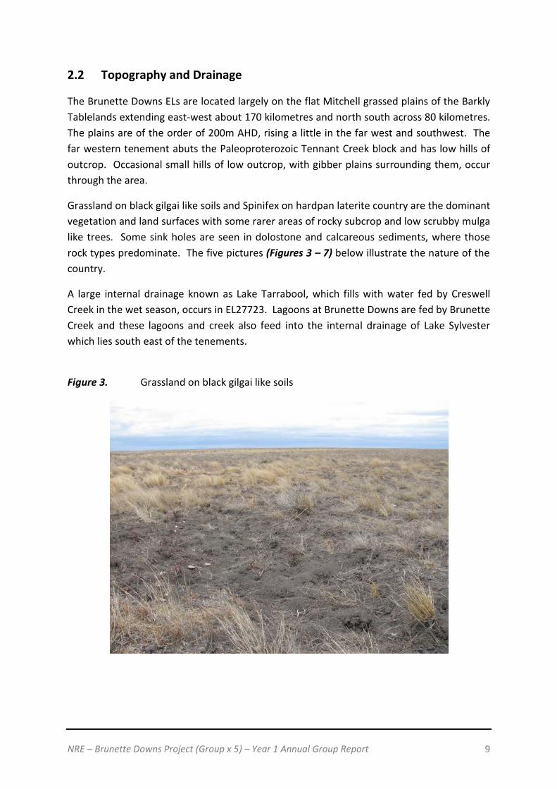
2.2 Topography and Drainage
The Brunette Downs ELs are located largely on the flat Mitchell grassed plains of the Barkly Tablelands extending east-west about 170 kilometres and north south across 80 kilometres. The plains are of the order of 200m AHD, rising a little in the far west and southwest. The far western tenement abuts the Paleoproterozoic Tennant Creek block and has low hills of outcrop. Occasional small hills of low outcrop, with gibber plains surrounding them, occur through the area.
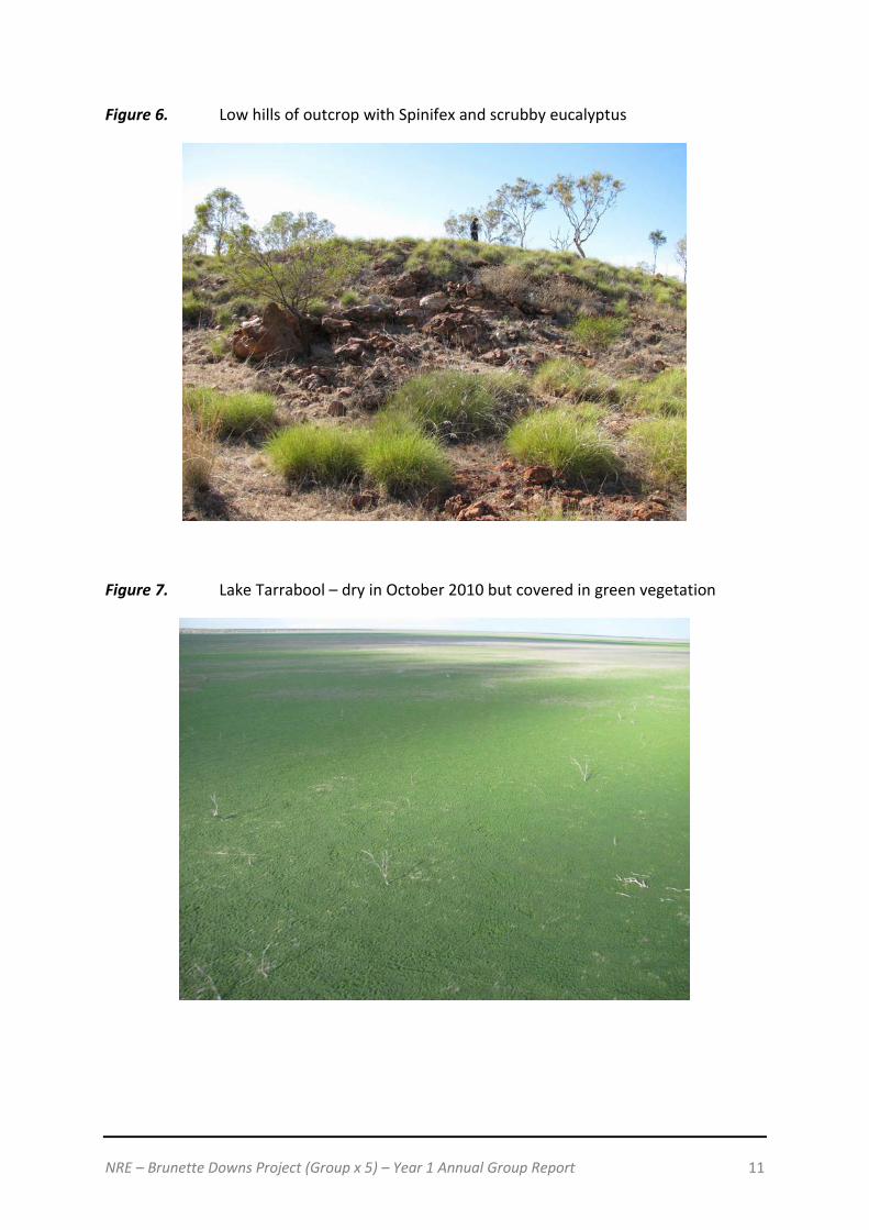
Grassland on black gilgai like soils and Spinifex on hardpan laterite country are the dominant vegetation and land surfaces with some rarer areas of rocky subcrop and low scrubby mulga like trees. Some sink holes are seen in dolostone and calcareous sediments, where those rock types predominate. The five pictures (Figures 3 – 7) below illustrate the nature of the country.
A large internal drainage known as Lake Tarrabool, which fills with water fed by Creswell Creek in the wet season, occurs in EL27723. Lagoons at Brunette Downs are fed by Brunette Creek and these lagoons and creek also feed into the internal drainage of Lake Sylvester which lies south east of the tenements.
Figure 3. Grassland on black gilgai like soils

NRE – Brunette Downs Project (Group x 5) – Year 1 Annual Group Report 10
Figure 4. Spinifex on hardpan laterite
Figure 5. Gibber plains and sub-outcrop to outcrop of sandstone
NRE – Brunette Downs Project (Group x 5) – Year 1 Annual Group Report 11
Figure 6. Low hills of outcrop with Spinifex and scrubby eucalyptus
Figure 7. Lake Tarrabool – dry in October 2010 but covered in green vegetation

NRE – Brunette Downs Project (Group x 5) – Year 1 Annual Group Report 12
3. Geology
3.1 Regional Geology
The Brunette Downs Project tenements are located entirely within the Neoproterozoic-Palaeozoic Georgina Basin, with a thin veneer of Carpentaria Basin rocks (Jurassic-Cretaceous) overlaying the Georgina Basin rocks in some parts of the northern ELs. The regional geology is shown in Figure 8 being the North Australia Proterozoic Units (after Rawlings et al 2008). A general stratigraphic column illustrating the rock relationships across part of the Helen Springs 1:250,000 geological map is shown in Figure 9. Figure 8. Regional Geology Map
The Georgina Basin is a broad, northwest-southwest trending intracratonic depression which underlies an area of some 325,000 square kilometres of the Northern Territory and Queensland. Approximately 60 percent of the basin area lies within the Northern Territory. In the northern and western parts of the Basin, including the areas covered by the Brunette Downs ELs, the Georgina Basin is underlain by continental flood basalts of the Helen Springs Volcanics. These flood basalts are up to 500m thick and overlie the older Neoproterozoic Renner Group rocks.

NRE – Brunette Downs Project (Group x 5) – Year 1 Annual Group Report 13
The Kalkarindji continental flood basalt province is the new stratigraphic name (Glass and Philips, 2006) for a number of scattered basalt suites across northern and central Australia, including the sub-aerial Antrim Plateau Volcanics (minimum volume of 0.15 x 10⁶ cubic kilometres) and intrusive Milliwindi dolerite dyke in the north, and the stratigraphically correlated Nutwood Downs, Helen Springs, Peaker Piker and Colless Volcanics in the east (Dunn, 1963; Bultitude, 1976; Hanley and Wingate, 2000). The Georgina Basin contains Cambrian and Ordovician, predominantly marine carbonate and clastic sediments, Devonian continental sediments and, in places, Neoproterozoic clastics. After an initial period of rift filling, sediments were deposited in a series of subtidal to supratidal environments over part of an extensive epicontinental shelf. The Palaeozoic sequence progressively thickens in a south-southeasterly direction, rarely exceeding 400 metres in the northern half of the basin, and reaching about 5000 metres in the southeast of the basin. The sedimentary sequence has been neither metamorphosed nor intruded by igneous rocks. The basin has been deformed by minor to moderate folding and faulting, especially in the south and east, with moderate to severe folding and faulting and extensive overthrusting along the southern and southwestern margin. Most of the structural deformation occurred during the Late Devonian to Early Carboniferous Alice Springs Orogeny. The northern part of the Georgina Basin sequence is gently undulating with no pronounced folding recognised other than supratenuous (drape) folding.

NRE – Brunette Downs Project (Group x 5) – Year 1 Annual Group Report 14
Figure 9. Stratigraphic column for rock units on Helen Springs 1:250K sheet.

NRE – Brunette Downs Project (Group x 5) – Year 1 Annual Group Report 15
3.2 Permit Geology
The permit / local geology within the Brunette Downs Project is generally poorly outcropping. The geology includes Cambrian units of the Georgina Basin with some remnant Cretaceous of the Dunmarra Basin and regolith (silcretes and calcretes) of Tertiary and Quaternary age and a unit known as the Brunette Limestone also of Tertiary-Miocene age. In particular, the units shown on the Helen Springs and Brunette Downs 1:250,000 geological sheets indicate only sparsely outcropping units of the Anthony Lagoon Beds/Formation of Cambrian age. These are often present in a regolith form for example as accumulations of chert pebbles. Other outcropping lithotypes include the Brunette Limestone, a white limestone with chert nodules and chalcedony, which probably formed under lacustrine conditions. The geology has been mapped and interpreted across the Helen Springs and Brunette Downs 1:250,000 geological sheets by government geologists who have mapped same in two phases, in 1966 and in 2001. The permit geology is illustrated in Figure 10 below. Figure 10. Permit Geology Map
Within the Brunette Downs tenure, the Georgina Basin rocks generally outcrop poorly and much of the interpretation of the geology has been based on a limited amount of subsurface drilling for either petroleum or phosphate. NTGS Record 2008/001 (Kruse 2008)

NRE – Brunette Downs Project (Group x 5) – Year 1 Annual Group Report 16
describes the correlations between a series of diamond drillholes drilled by the NTGS between 1996 and 2006. Three of these drillholes (NTGS96/1, BN04DD01 and NTGS02/1) lie either within or close to the boundary of the Brunette Downs ELs. The three drillholes form a roughly co-linear series 174 kilometres long starting in the west at a point 44 kilometres east-southeast of Renner Springs on the Stuart Highway to a point 25 kilometres west-southwest of the Brunette Downs homestead. The location of the three drillholes is shown in Figure 11 and the correlations between these three holes are illustrated in Figure 12. Figure 11. Location of NTGS diamond drillholes (after Kruse 2008).
Figure 12. Correlations between three drillholes on a line across the southern boundary of the Brunette Downs Project (after Kruse 2008).

NRE – Brunette Downs Project (Group x 5) – Year 1 Annual Group Report 17
It can be seen that essentially only three pre-Tertiary units are present, the basement Helen Springs Volcanics, the Gum Ridge Formation and the Anthony Lagoon Formation (Figure 11). A detailed description is given of the two (2) main Georgina Basin Formations, the Gum Ridge Formation and the Anthony Lagoon Beds.
The Gum Ridge Formation
The stratotype section spans the interval 84, 4 – 234.9m depth in drillhole NTGS96/1 in Helen Springs 1:100,000 geological map sheet (Kruse 1998, Kruse and Hussey et al 2001). Essentially, the Gum Ridge Formation comprises tow successive marine limestone units, each underlain by thin (8 – 10m thick) peritidal siliciclastic intervals. Basal beds are thus of mottled, finely brecciated brown-maroon dolomitic siliciclastic siltstone, whereas the medial pertidal interval (143 – 153m depth) is of mottled grey mudstone with associated microbial dololaminite.
The predominate marine limestone is light grey to yellow-grey, and includes: vaguely laminated massive limestone with stylolites, solution seams, spheroidal concretions and thin interbeds of darker grey, more siliciclastic carbonate mudstone; mottled lithoclast bioclast wackestone; well bedded to bioturbated-nodular ribbon limestone (comprising centimetre-scale interbeds of dark grey, partially silicilastic dolosparstone and light grey calcimudstone to bioclast wackestone; (Coniglio and James 1990); and minor oncoid (dolo)rudstone of oncoids up to 2 – 3 cm diameter in a calcimudstone matrix, which locally includes bioclasts or peloids. The marine limestone is dolomitised adjacent to siliciclastic intervals, particularly toward the formation top, whiere it is strongly dolomitised to dolosparstone. Evaporite nodules and solution-collapse brecciation recur throughout.
The same range of lithotypes is present in drillhole BN4DD01 in western Brunette Downs 1:100,000 geological map sheet. In this drillhole, the basal maroon dolomitic-siliciclastic siltstone incorporates reworked medium-course basaltic sand immediately above the underlying Helen Springs Volcanics. Further east, in drillhole NTGS02/1 in eastern Brunette Downs 1:100,000 geological map sheet, the marine limestone is more pervasively crystallised to sparstone, with intervals of light brown nodular dolomitisation and mottling, yet preserves tracts of bioclast wackestone at the formation top.
The basal 1m is a distinctive conglomerate of rounded to subangular quartz sandstone pebbles and cobbles, reworked from the underlying South Nicholson Group, in partially dolomitic maroon-brown medium sand to granule matrix. This matrix penetrates fractures in the uppermost 0.5m of the South Nicholson Group to create a fitted fabric. Evaporites recur in both of these drillholes, as does pyrite. Either disseminated, concentrated along fractures, stylolites and other lithological interfaces, or replacing lithoclasts and bioclasts.

NRE – Brunette Downs Project (Group x 5) – Year 1 Annual Group Report 18
Like the Top Springs Limestone, the Gum Ridge Formation represents deposition on a restricted marine shelf, although additionally subjected to episodic peritidal influence.
The exposed Gum Ridge Formation offers only a selective sampling of this subsurface lithological variety. Outcrop is pervasively silicified and/or ferruginised to red-brown, cream or grey chert that typically occurs as subsequent rubble on or beside topographic highs.
Anthony Lagoon Formation
The formation has a stratotype section spanning the interval 12.2 – 256.4m depth in cored drillhole BN04DD01 in western Brunette Downs 1:100,000 geological map. This stratotype provides the maximum known thickness of 244.2m. Outcrop is widespread in the Barkly Sub-basin.
The Anthony Lagoon Formation is a heterolithic carbonate-siliciclastic unit incorporating dolomitic siliciclastic siltstone, dolomitic sandstone-siltstone interbeds, quartz sandstone and a variety of carbonate rock types. Nodular and bedded evaporate and siliceous (chert) concretions are common. Cored drillholes NTGS96/1 in central Helen Springs (Kruse 1996, Hussey et al 2001), BN04DD01 in western Brunette Downs (Kruse 2008) and NTGS02/1 in eastern Brunette Downs (Kruse 2003, 2008) collectively furnish a complete record of the formation in an east-west transect across the Barkly Sub-basin. The lithology is described here as a suite of constituent lithotypes, modified from Kruse et al (1990, 1994). The maroon dolomitic siliciclastic siltstone and grey dolomitic-siliciclastic mudstone lithotopes are rarely preserved at surface, and never in an uncertified state. The carbonate lithotopes are likewise prone to boulder rubble, in which chert concretions predominate. Nevertheless, significant outcrop tracts of unsilicified carbonate rocks, as well as dolomitic quartz sandstone, have been mapped.
The most common of the siliciclastic lithotopes consists of fine dolospar and interstitial iron oxides ± clays, the latter imparting the distinctive maroon-brown colour to the rock, together with scattered angular-subangular, fine silt to very fine sand-sized detrital quartz, and minor detrital muscovite. This siltstone typically displays a shredded texture, due to dissolution and transport of component evaporates and consequent microbrecciation.
Unlike the more common maroon siltstone, the grey dolomitic-siliciclastic mudstone is typically light brown-grey and lacks visible evidence of evaporates and is characteristically massive and undisturbed. It occurs in all three drillholes, with a maximum interval of 1.6m thickness in NTGS96/1.
Light grey dolomudstone (typically now dolomicrosparstone) is the dominant lithotope in drillcore, representing some 60% of the Anthony Lagoon Formation. It occurs in intervals ranging from decimetre scale up to 16m in thickness. It is variably recrystallised to porous

NRE – Brunette Downs Project (Group x 5) – Year 1 Annual Group Report 19
to vuggy dolosparstone, which may additionally be pale brown or locally, salmon in colour. Mid-to dark grey siliciclastic laminations and thin interbeds are characteristic, as are bedding-parallel (rarely steeply inclined) stylolites. The dolomudstone is locally siliciclastic-silty (and pink-grey to maroon-grey in colour) and/or quartzic or less commonly, glauconitic. Included thing intervals of microbial dololaminite are minor. Dolomite concretions and chert concretions and nodules occur at irregular intervals.
The Anthony Lagoon Formation is co-eval with the Wonarah Formation. However, the two units formed in significantly different environments. The Wonarah Formation interdigitates with the peritidal Anthony Lagoon Formation. The known maximum thickness of the Wonarah Formation is 191m (top not preserved) in cored drillhole NTGS00/1 on the Alexandria-Wonarah Basement High (Kruse 2003). In the subsurface in cored drillholes NTGS001/1 and NTGS01/1, the Wonarah Formation is an essentially platformal marine unit comprising light grey, occasionally mottled silty dolostone with common planar to wavy, siliciclastic mudstone and some finely quartzic laminations; and centimetre-scale interbeds of light grey calcidolomudstone and dark grey siliciclastic mudstone. These two principal lithotypes are intergradational, and locally recrystallised to dolosparstone. They exhibit varying degrees of pressure solution ‘boudinage’ and possible bioturbation.
Intraclast and bioclast wacke-to grainstone and oncoid pack/grainstone are minor. Early and late diagenetic dolomitic concretions, siliceous (chert) concretions and pyrite recur throughout. Evaporites are locally present as nodular and vein-filling anhydrite or bedding-sub parallel gypsum veins, as in basal beds of the formation in NTGS00/1. Because of this interfingering of the peritidal Anthony Lagoon Formation sediments with those of the marine, carbonate-dominated Wonarah Formation, it is possible that if basement highs can be identified within the stratigraphic sequences within the Brunette Downs Project, then the more phosphate prospective Wonarah Formation may be present. Identifying these highs would be the main focus of future exploration.

NRE – Brunette Downs Project (Group x 5) – Year 1 Annual Group Report 20
4. NRE’s Exploration Activities during the Reporting Period
NRE’s exploration program for the first term consisted of an initial regional assessment of areas within the Brunette Downs Project for phosphate and other commodities. The targets within the Brunette Downs Project areas were identified based on desk top research of regional geological and geophysical data, augmented with compilation and assessment of all previous exploration results. The aim of work was to carry out a field assessment of the five (5) tenements forming the Brunette Downs Project, and prospects in order to identify target characteristics and define the next phase of exploration. An array of material was assessed prior to field work to assist with optimal target generation and included:
• Data from all previous exploration as documented in open file reports retrieved from the Northern Territory Government, including:
o Surface geological sampling, o Geochemical anomalism mapping, o Geological mapping, o Detailed geophysical survey data, o Geophysical anomalism mapping, o Drilling results, and o Local and regional geological assessments and conclusions derived from
exploration programs.
• Water bore data available for all bores drilled in the regions of interest. This data includes geological logging and water assaying.
• Geological maps provided by the Northern Territory Government.
• Aeromagnetics, aero-radiometrics and gravity surveys provided by the Northern Territory Government.
• Satellite imagery, ASTER and Google Earth imagery.
• Data supplied by landowners in relation to geological and topographic features of interest on their properties.

NRE – Brunette Downs Project (Group x 5) – Year 1 Annual Group Report 21
4.1 Previous Exploration Studies
NRE has conducted an extensive review of historic exploration over its Brunette Downs Project. The Georgina Basin has been explored for petroleum, gas, phosphate, potash, base metals, uranium and diamond pipes (potential intrusive pipes). There has been exploration for a variety of commodities across the Brunette Downs ELs, targeting diamonds, uranium and phosphate. IMC Development Corporation explored for phosphate deposits, but had little success in the region covered by the Brunette Downs Project ELs. The Shell Company explored for basement copper gold in the western parts of the Brunette Downs ELs but found no Paleoproterozoic basement of the type they sought. Diamond exploration by ADE Joint venture, DeBeers and Stockdale Prospective, recovered numerous microdiamonds, but were ultimately unsuccessful in locating kimberlite pipes. Previous exploration has been summarised in Table 2 and location of historic tenements is shown in Figure 13. Table 2. Historic Tenures
Tenure Period Reports Company Target AP1801, 1766 et al
1967-1969 CR1968-0030, CR1969-0022, CR1969-0025, CR1970-0037
IMC Development Corp – Mines Exploration
Phosphate
AP1919 1967-1969 CR1968-0046 Sampey Expl Services – Tipperary Land Corp
Phosphate
AP2757 1970-1971 CR1971-0028 Dillingham Mining Co Copper Gold EL2878 1981-1983 CR1982-0187 The Shell Co of Aust Copper Gold EL4253 1985-1988 CR1985-0013, CR1986-0071 ADE JV – Ashton/Aberfoyle/AOG Diamonds EL4312-EL4318 incl
1986-1988 CR1986-0122, CR1985-0040, CR1986-0067, CR1986-0079, CR1986-0082
ADE JV – Ashton/Aberfoyle/AOG Diamonds
EL4328-EL4331 1985-1988 CR1984-0222, CR1985-0230, CR1986-0291, CR1984-0223, CR1986-0292, CR1984-0225, CR1986-0294
ADE JV – Ashton/Aberfoyle/AOG Diamonds
EL8559, EL8562, EL8563
1993-1994 CR1994-0806, CR1994-0804, CR1994-0805
Stockdale Prospecting Diamonds
EL23128, EL23129, EL23130
2003-2004 CR2004-0046 De Beers Australia Exploration Ltd Diamonds
EL25060 2006-2009 CR2007-0459, CR2008-0558, CR2008-0752, CR2009-0892
Territory Uranium Co (TUC) Uranium
EL25071 2006-2008 CR2007-0327 Territory Uranium Co (TUC) Uranium EL25082 2006-2008 CR2007-0460 Territory Uranium Co (TUC) Uranium EL25992 2008-2009 CR2008-0851 Uramet Minerals Uranium EL26370, EL26371 2008-2009 CR2008-0928, CR2008-0929 Independence Group Diamonds EL25631 2008-2010 CR2010-0046 Crossland Uranium Uranium-
Phosphate
NRE – Brunette Downs Project (Group x 5) – Year 1 Annual Group Report 22
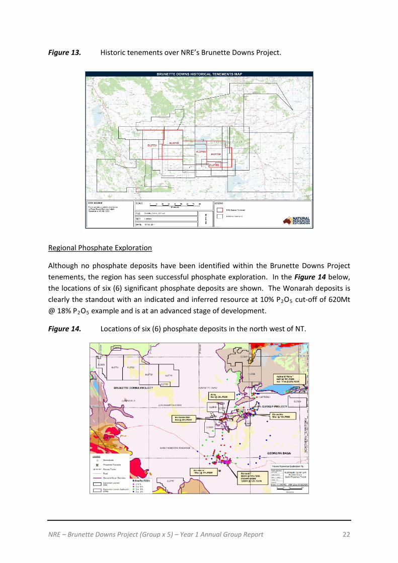
Figure 13. Historic tenements over NRE’s Brunette Downs Project.
Regional Phosphate Exploration
Although no phosphate deposits have been identified within the Brunette Downs Project tenements, the region has seen successful phosphate exploration. In the Figure 14 below, the locations of six (6) significant phosphate deposits are shown. The Wonarah deposits is clearly the standout with an indicated and inferred resource at 10% P2O5 cut-off of 620Mt @ 18% P2O5 example and is at an advanced stage of development.
Figure 14. Locations of six (6) phosphate deposits in the north west of NT.

NRE – Brunette Downs Project (Group x 5) – Year 1 Annual Group Report 23
4.2 Helicopter Reconnaissance
NRE completed a reconnaissance helicopter assisted field trip of the Brunette Downs Project in October 2010. NRE introduced themselves to local landholders (Figure 15), assessed a number of field targets across the tenement and carried out geological mapping of the project area. The field trip proved successful in evaluating the tenement in the most effective and timely manner possible.
Figure 15. Cadastral Map
Field assessment of the prospects involved an initial low fly over before determining whether a landing was viable for each target site. In most cases, a landing was made. Assessment at each site involved a variety of the following tasks:
• Geological and structural note taking and measurements • Radiometric measurements • Collection of soils and rock chips • Observations of outcrop boundaries where relevant • Botanical and physiographic appraisal • Photography of the features of interest at each site.

NRE – Brunette Downs Project (Group x 5) – Year 1 Annual Group Report 24
Detailed geological characteristics were recorded at each site and bulk surface samples were collected.
In addition to planned target sites, all areas identified in the air as being characterized by features anomalous to that mapped or revealed in currently available data sets were assessed. Figure 16 and Figure 17 illustrate the projects, target sites and helicopter paths flown to, for site assessment.
Upon returning from the field all data was compiled and summarised in order to assemble a comprehensive report outlining details of each of the tenements’ mineral prospectivity and recommendations for the next phase of exploration.
Figure 16. Reconnaissance targets and rock chip samples
Before the samples were forwarded to the laboratory, they were assessed with a portable XRF for any mineralisation.
Geological ground truthing has produced new information regarding surface characteristics across the region. It has been noted that regional geological mapping is not accurate over large areas of the tenements. Observations have been made at all target sites detailing the actual setting to ensure follow up work is carried out with optimal effectiveness.

NRE – Brunette Downs Project (Group x 5) – Year 1 Annual Group Report 25
An assessment has been made of each target visited during the program in order to make recommendations for future exploration. All field observations and assay data collected from the field trip were assimilated in order to optimally define prospectivity based on this work. Integration with all available data sets enabling further delineation of mineral potential has been recommended where appropriate.
Figure 17. Flight path of helicopter reconnaissance program.
Despite widespread and thorough coverage, no obvious targets at surface were delineated within the Brunette Downs tenements. Low levels of phosphate and potassium have been identified in some areas, but not at levels warranting immediate follow up.
Seventy five (75) sites were investigated across the area, with work successfully delineating the surface geological, mineralogical, botanical and topographic features across many of the tenements. However, no significant mineralisation was seen at the surface and drilling is required to further understand the stratigraphic sequence.
Field work has shown that regional geological mapping across a great deal of the tenements is not accurate. Detailed observations have been made at target sites. Integration of this data with regional information and advanced interpretation of data sets, particularly ASTER, will greatly assist in drill targeting.
NRE – Brunette Downs Project (Group x 5) – Year 1 Annual Group Report 26
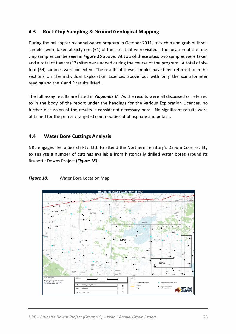
4.3 Rock Chip Sampling & Ground Geological Mapping
During the helicopter reconnaissance program in October 2011, rock chip and grab bulk soil samples were taken at sixty-one (61) of the sites that were visited. The location of the rock chip samples can be seen in Figure 16 above. At two of these sites, two samples were taken and a total of twelve (12) sites were added during the course of the program. A total of six-four (64) samples were collected. The results of these samples have been referred to in the sections on the individual Exploration Licences above but with only the scintillometer reading and the K and P results listed. The full assay results are listed in Appendix II. As the results were all discussed or referred to in the body of the report under the headings for the various Exploration Licences, no further discussion of the results is considered necessary here. No significant results were obtained for the primary targeted commodities of phosphate and potash. 4.4 Water Bore Cuttings Analysis
NRE engaged Terra Search Pty. Ltd. to attend the Northern Territory’s Darwin Core Facility to analyse a number of cuttings available from historically drilled water bores around its Brunette Downs Project (Figure 18).
Figure 18. Water Bore Location Map
NRE – Brunette Downs Project (Group x 5) – Year 1 Annual Group Report 27
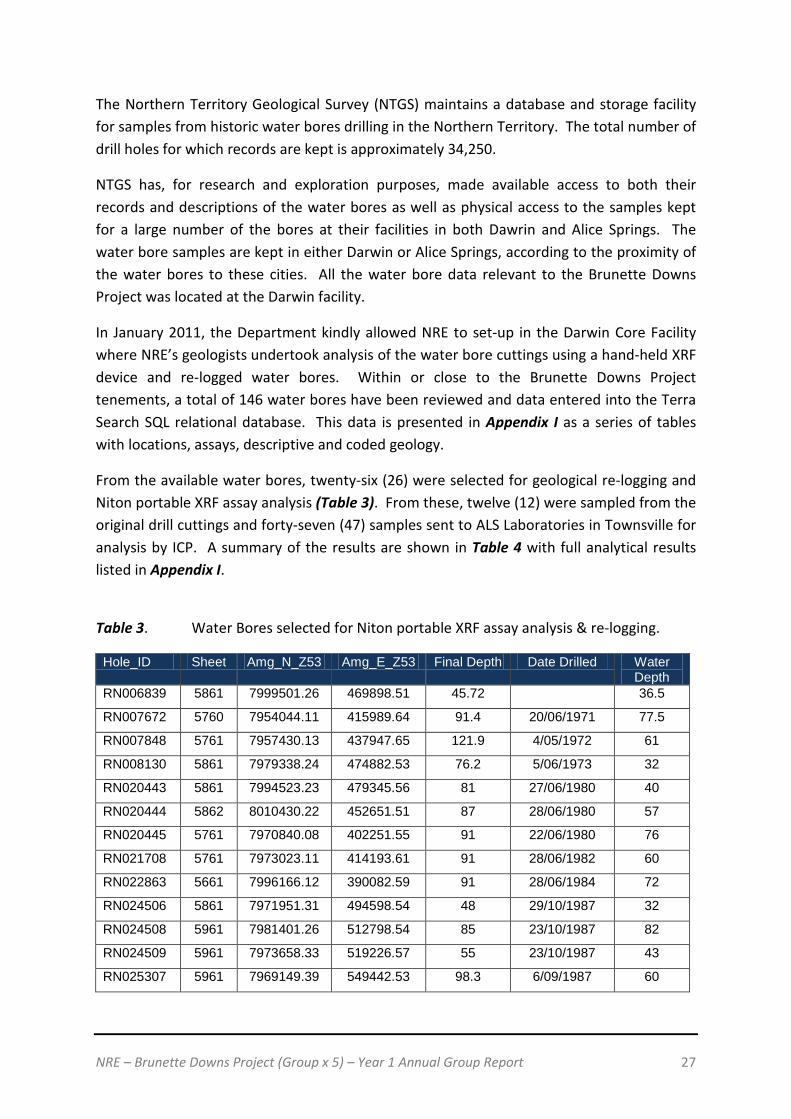
The Northern Territory Geological Survey (NTGS) maintains a database and storage facility for samples from historic water bores drilling in the Northern Territory. The total number of drill holes for which records are kept is approximately 34,250.
NTGS has, for research and exploration purposes, made available access to both their records and descriptions of the water bores as well as physical access to the samples kept for a large number of the bores at their facilities in both Dawrin and Alice Springs. The water bore samples are kept in either Darwin or Alice Springs, according to the proximity of the water bores to these cities. All the water bore data relevant to the Brunette Downs Project was located at the Darwin facility.
In January 2011, the Department kindly allowed NRE to set-up in the Darwin Core Facility where NRE’s geologists undertook analysis of the water bore cuttings using a hand-held XRF device and re-logged water bores. Within or close to the Brunette Downs Project tenements, a total of 146 water bores have been reviewed and data entered into the Terra Search SQL relational database. This data is presented in Appendix I as a series of tables with locations, assays, descriptive and coded geology.
From the available water bores, twenty-six (26) were selected for geological re-logging and Niton portable XRF assay analysis (Table 3). From these, twelve (12) were sampled from the original drill cuttings and forty-seven (47) samples sent to ALS Laboratories in Townsville for analysis by ICP. A summary of the results are shown in Table 4 with full analytical results listed in Appendix I.
Table 3. Water Bores selected for Niton portable XRF assay analysis & re-logging.
Hole_ID Sheet Amg_N_Z53 Amg_E_Z53 Final Depth Date Drilled Water Depth
RN006839 5861 7999501.26 469898.51 45.72 36.5
RN007672 5760 7954044.11 415989.64 91.4 20/06/1971 77.5
RN007848 5761 7957430.13 437947.65 121.9 4/05/1972 61
RN008130 5861 7979338.24 474882.53 76.2 5/06/1973 32
RN020443 5861 7994523.23 479345.56 81 27/06/1980 40
RN020444 5862 8010430.22 452651.51 87 28/06/1980 57
RN020445 5761 7970840.08 402251.55 91 22/06/1980 76
RN021708 5761 7973023.11 414193.61 91 28/06/1982 60
RN022863 5661 7996166.12 390082.59 91 28/06/1984 72
RN024506 5861 7971951.31 494598.54 48 29/10/1987 32
RN024508 5961 7981401.26 512798.54 85 23/10/1987 82
RN024509 5961 7973658.33 519226.57 55 23/10/1987 43
RN025307 5961 7969149.39 549442.53 98.3 6/09/1987 60

NRE – Brunette Downs Project (Group x 5) – Year 1 Annual Group Report 28
RN025562 5861 7959672.15 447179.59 103 6/12/1987 63
RN025860 5861 8004136.18 454550.53 129.5 26/11/1988 60
RN026266 5861 7956699.23 461101.56 67 19/11/1988 36
RN027070 5761 8000060.14 401101.54 84 29/06/1990 55
RN027948 5860 7947347.18 462612.67 78 28/04/1992 48
RN028414 5761 7996846.14 440501.55 104 10/12/1992 60
RN028921 5661 7978023.13 393726.6 84 5/06/1994 72
RN030137 5961 7969695.3 530792.53 63 20/07/1995 45
RN032555 5761 7963865.16 421243.65 232.3 28/07/2000 66
RN032556 5761 7960141.14 431878.61 163.5 24/07/2000 66
RN033533 5961 7974168.32 535489.25 87 23/09/2002 76
RN033744 5961 7975989.33 545483.3 102 29/07/2003 88
RN034186 5961 7986613.39 502888.08 48 8/12/2004 40
Table 4. Summary of waterbore ALS results.
Hole_ID Sample From Depth
To Depth
Cu (ppm)
K (ppm)
P (ppm)
Pb (ppm)
Zn (ppm)
RN026266 5014193 45 48 105 7500 730 314 170
RN030137 5014198 15 18 109 11900 260 309 177
RN030137 5014199 18 21 1190 10000 240 334 171
RN030137 5014202 21 24 69 10900 190 319 161
RN030137 5014203 24 27 87 11800 210 316 165
RN030137 5014204 27 30 63 11300 190 313 161
RN032555 5014209 174 177 12 900 280 29 583
RN033744 5014214 9 12 56 4700 240 343 98
RN033744 5014216 15 18 65 7400 1160 425 133
RN033744 5014217 18 21 58 5800 1310 358 124
RN033744 5014218 96 99 678 6700 430 86 39
RN033744 5014219 99 102 390 7300 510 83 48

NRE – Brunette Downs Project (Group x 5) – Year 1 Annual Group Report 29
Figure 19. Location of water bores listed in Table 5.
The overall results of the Niton portable XRF testing and the analytical samples showed that no significant potassium or phosphate anomalies were present. The values for P were all less than 0.2% and for K were all less than 2%. Other results of interest are included in Table 4; three samples returned higher than 300ppm Cu. Nine samples had Pb values in excess of 300ppm. One sample had greater than 500ppm Zn. The location of water bores which returned these results are shown in Figure 19.
NRE lodged an Exploration Report with the Northern Territory Department of Resources’ Geoscience Division on 7 June, 2011. This report was required in respect of the XRF and ALS Assaying of Water Bore Chips at the Darwin Core Facility. The Exploration Report was titled ‘XRF & ALS Assaying of Water Bore Chips – Core Facility: Darwin’.

NRE – Brunette Downs Project (Group x 5) – Year 1 Annual Group Report 30
4.5 Tenement Summaries
EL27721 - Monmoona
Monmoona is the western most tenement within the granted block. Regional geological mapping indicates widespread outcrop and sub-crop of Cambrian Anthony Lagoon Beds, a unit potentially prospective for phosphate.
Field targets were originally developed to ensure the surface expression of this unit was assessed and all uranium and potassium radiometric anomalies were also focused upon. Twenty (20) target sites were visited on EL277221 during the field program in October 2011. The sites are illustrated in Figure 20.
Geological mapping of the area indicates extensive outcrop and sub-crop of Cambrian stratigraphy amongst recent soil cover. Field observations prove that this outcrop has commonly been inaccurately mapped an soils with or without transported float material are in fact present at surface. In some places the float may be representative of sub-crop, indicating very shallow Cambrian occurrence.
Aerial observations indicate that vegetation changes commonly correlate with mapped geological boundaries and it is apparent that botanical patterns have been utilized to interpret Cambrian outcrop. Furthermore, in the regions mapped as Cambrian, there is often coarse float material having the appearance of possible outcrop from the air. Field observations have been taken across the tenements detailing actual surface geological characteristics and a large library of photographs has been compiled, as highlighted in Figure 21 to Figure 24. Ground truthing of regional geology has provided a valuable data set to ensure future exploration by NRE will be optimised.
Laboratory results indicate that there is no mineral anomalism at surface, with insignificant values being returned for all of the thirty-five (35) elements assayed (Appendix II). Table 5 highlights the field observations, scintillometer measurements, phosphorous and potassium levels recorded at each site. All uranium levels in surface samples are below the limit of detection.
No mineralisation of note is evident at surface on EL27721. However, the reconnaissance survey has provided data relating to the surface geology, botany and topography of the region. This is being integrated with ASTER data in order to delineate regional surface features and enable modelling of the possible subsurface characteristics in the second year of grant.

NRE – Brunette Downs Project (Group x 5) – Year 1 Annual Group Report 31
Figure 20. More detailed image of the targets visited within EL27721.
NRE – Brunette Downs Project (Group x 5) – Year 1 Annual Group Report 32
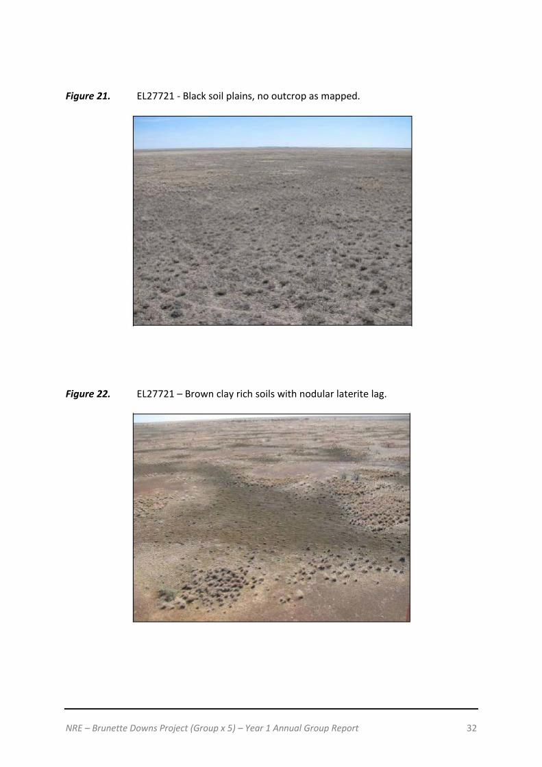
Figure 21. EL27721 - Black soil plains, no outcrop as mapped.
Figure 22. EL27721 – Brown clay rich soils with nodular laterite lag.

NRE – Brunette Downs Project (Group x 5) – Year 1 Annual Group Report 33
Figure 23. EL27721 – Sandstone sub-crop and outcrop.
Figure 24. EL27721 – Ripple marks in sandstone.

NRE – Brunette Downs Project (Group x 5) – Year 1 Annual Group Report 34
Table 5. EL27721 – Summary of targets visited.

NRE – Brunette Downs Project (Group x 5) – Year 1 Annual Group Report 35

NRE – Brunette Downs Project (Group x 5) – Year 1 Annual Group Report 36
EL27722 - Eva Downs
Eva Downs is one of the central tenements within the Brunette Downs project. Regional geological mapping indicates widespread recent soil cover and occasional outcrop and sub-crop of Cambrian Anthony Lagoon Beds, a unit potentially prospective for phosphate.
A large potassium anomaly extending across the majority of the eastern half of the tenements was targeted for its potash potential. Field targets were developed to ensure coverage of all geological and geophysical features of interest across the tenement to optimally delineate mineral potential.
Nine (9) target sites were visited on Eva Downs, a tenement considered primarily prospective for phosphate and potash. Targets within EL27722 are shown in Figure 25.
The region is predominantly comprised of black and brown soil plains with occasional float and minor sandstone outcrop.
No significant elevation of any mineral has been indicated from testing of the thirty-five (35) elements for each of the surface samples collected. A full list of laboratory results are detailed in Appendix II and potassium and phosphorous values are included in Table 6. The potassium anomalies revealed on radiometric imaging are indeed existent in the field but are only indicative of an elevation of this element in these zones, compared to surrounding ground.
No mineralisation of note is evident at surface on Eva Downs. Data collected from the reconnaissance survey will be used to carry out advanced interrogation of ASTER imagery. The various surface environments are to be modelled, enabling interpretation of potential sub-surface geological characteristics.
The prevailing geological and landscape features across EL27722 are illustrated in Figure 26 to Figure 29.

NRE – Brunette Downs Project (Group x 5) – Year 1 Annual Group Report 37
Figure 25. More detailed image of the targets visited within EL27722.

NRE – Brunette Downs Project (Group x 5) – Year 1 Annual Group Report 38
Table 6. EL27722 – Summary of targets visited.
Figure 26. EL27722 – Grey black clay rich soil with carbonate nodules.

NRE – Brunette Downs Project (Group x 5) – Year 1 Annual Group Report 39
Figure 27. EL27722 – Brown soils with ferruginous, cherty float.
Figure 28. EL27722 – Grey-black sandy clay soils with carbonate nodules and gastropod shells.

NRE – Brunette Downs Project (Group x 5) – Year 1 Annual Group Report 40
Figure 29. EL27722 – Sandstone outcrop.

NRE – Brunette Downs Project (Group x 5) – Year 1 Annual Group Report 41
EL27723 - Tarrabool Lake
Tarrabool Lake is one of the two central granted tenements within the Brunette Downs Project. It is considered to be primarily prospective for phosphate, potash and uranium.
Target sites were developed based on radiometric anomalism, features of interest delineated on ASTER imagery and regionally mapped outcrop/sub-crop of potentially phosphatic Cambrian stratigraphy. The locations of points assessed in detail across the tenement are illustrated in Figure 30.
Sixteen (16) sites were assessed on the reconnaissance field trip, six (6) more than originally planned based on desk top assessment of the region. These extra localities were all identified from the air as having interesting characteristics not previously delineated on regional maps. Observations at each target area summarised in Table 7 and fully detailed in Appendix II.
The tenement area primarily consists of black and brown soil plains with large lacustrine deposits in the north. Several expanses of previously unidentified sandstone and limestone outcrop/sub-crop have been delineated as a result of field reconnaissance. These units are interpreted as being Cambrian in age with potential phosphatic horizons at depth. This field mapping suggests there may be a broader range of sub-surface geological units across a larger expanse of the tenement and an enhanced prospectivity.
A recently constructed dam to 6m depth was identified in the field. Mapping the geological profile in this dam has given a clearer picture of soil depths and the underlying stratigraphy.
Very low level phosphorous and low level potassium, up to 1.08% has been identified at surface on the tenement. No significant levels of any of the thirty-five (35) elements assayed were identified in any of the fifteen (15) samples taken.
Reconnaissance assessment has indicated that there are no surface targets with any phosphatic or potash anomalism requiring follow up on Tarrabool Lake. Data collected from the reconnaissance survey will be utilized to carry out advanced interrogation of ASTER imagery. This will be used to model the various surface environments, enabling interpretation of potential sub-surface geological characteristics.
The prevailing topographic, botanical and geological settings across the tenement and at specific target sites are illustrated in Figure 31 to Figure 34.

NRE – Brunette Downs Project (Group x 5) – Year 1 Annual Group Report 42
Figure 30. More detailed image of the targets visited within EL27723.

NRE – Brunette Downs Project (Group x 5) – Year 1 Annual Group Report 43
Table 7. EL27723 – Summary of targets visited.
NRE – Brunette Downs Project (Group x 5) – Year 1 Annual Group Report 44
Figure 31. EL27723 – Black clay rich soil, sample site.
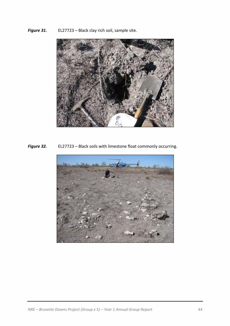
Figure 32. EL27723 – Black soils with limestone float commonly occurring.

NRE – Brunette Downs Project (Group x 5) – Year 1 Annual Group Report 45
Figure 33. EL27723 – Base of newly constructed dam. Black soils to 2 – 3m with siltstone, carbonate and chert to bottom of dam.
Figure 34. EL27723 – Limestone outcrop, previously unidentified on geological maps.

NRE – Brunette Downs Project (Group x 5) – Year 1 Annual Group Report 46
EL27749 - Mudges Bore
Mudges Bore is considered potentially prospective for phosphate, potash and to a lesser extent, uranium.
The primary targets delineated for surface assessment were defined based on radiometric anomalism (uranium and potassium), ASTER features of interest and the mapped Cambrian outcrop with phosphate potential in the region.
The regional geological setting and target sites for reconnaissance work are illustrated in Figure 35.
Sixteen (16) sites were targeted in the field in order to assess the mineral potential of the tenement, as summarized in Table 8 and described in detail in Appendix II.
Extensive outcrop of Cambrian lithology with phosphate potential has been mapped in the north of EL27749 by government geologists. A great deal of this area is in fact characterised by float or zones of vegetation that vary in comparison to the surrounds, with outcrop often being absent where mapped. It was necessary to fully utilize the advantage of having an extended aerial view across the plain in order to identify the sporadic patches of sandstone and siltstone outcrop and sub-crop. Figure 36 to Figure 39 illustrate the prevailing settings at a variety of the targets.
No high levels of potassium or phosphorous were identified in the surface samples collected, with a maximum potassium value of 1.09% in a zone delineated on regional radiometrics as having an anomalous level of the element in the south of the tenement.
No significant mineral targets have been delineated through surface reconnaissance assessment of EL27749. It is possible that mineralisation occurs at depth in phosphatic horizon(s) of the Anthony Lagoon Beds or in evaporitic sequences with anomalous levels of potassium.
The reconnaissance phase of exploration has provided a data set detailing a wide variety of previously unidentified surface features that will be utilized in advanced ASTER interpretation. This will enable modelling of the regional surface characteristics and assist in delineating potential zones of sub-surface mineral potential.

NRE – Brunette Downs Project (Group x 5) – Year 1 Annual Group Report 47
Figure 35. More detailed image of the targets visited within EL27749.
NRE – Brunette Downs Project (Group x 5) – Year 1 Annual Group Report 48
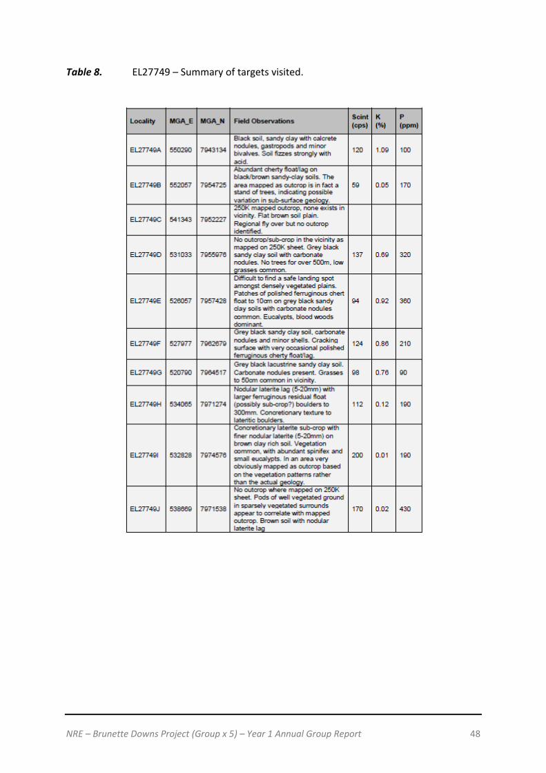
Table 8. EL27749 – Summary of targets visited.

NRE – Brunette Downs Project (Group x 5) – Year 1 Annual Group Report 49
Figure 36. EL27749 - A stand of trees representing possible sub-surface geological variation to surrounds, mapped previously as outcrop but none present.

NRE – Brunette Downs Project (Group x 5) – Year 1 Annual Group Report 50
Figure 37. EL27749 – Sandstone ridge.
Figure 38. EL27749 – Sandstone cropping out on ridge.
NRE – Brunette Downs Project (Group x 5) – Year 1 Annual Group Report 51
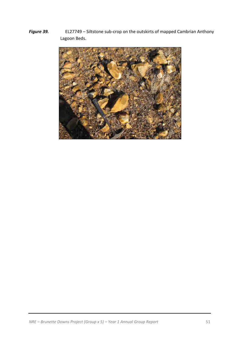
Figure 39. EL27749 – Siltstone sub-crop on the outskirts of mapped Cambrian Anthony Lagoon Beds.

NRE – Brunette Downs Project (Group x 5) – Year 1 Annual Group Report 52
EL27768 - Brunette Dam
Brunette Dam is the smallest of the tenements within the Brunette Downs Project, comprising of sixty-one (61) sub-blocks in the southeast of the tenure. It is considered to have potential primarily for phosphate and potash.
Nine (9) targets were identified and assessed in the field, as summarised in Table 9. Full details of field observations and sample assays are included in Appendix II.
Cambrian Anthony Lagoon Beds have been previously mapped across a great extent of the tenement, but field observations indicate that this lithology is not present at surface for the most part. Zones of sub-crop exist sporadically and a substantial ridge of limestone has been identified for the first time as a result of our regional fly over the tenement. Targets assessed in the field are outlined in Figure 40 and Figure 41 to Figure 44 illustrate target site characteristics.
No significant levels were recorded for any of the thirty-five (35) elements tested for each of the surface samples taken. Slightly elevated vanadium was identified in a bulk soil sample collected in EL27768 (338ppm).
As for all other tenements within the Brunette Downs Project, field reconnaissance of EL27768 has not delineated any surface targets requiring follow up. However, it is possible that mineralization occurs at depth in possible phosphatic horizon(s) in the Anthony Lagoon Beds or in evaporitic sequences with anomalous levels of potassium.
The reconnaissance phase of exploration has provided a data set detailing a wide variety of previously unidentified surface features that will be utilized in advanced ASTER interpretation. This will enable modelling of the regional surface characteristics and assist in delineating potential zones of sub-surface mineral potential.
Figure 40. More detailed image of the targets visited within EL27768.

NRE – Brunette Downs Project (Group x 5) – Year 1 Annual Group Report 53
Table 9. EL27768 – Summary of targets visited.
Figure 41. EL27768 – Region mapped as being characterized by Cambrian Anthony Lagoon Beds, minor float noted but no outcrop in the region.

NRE – Brunette Downs Project (Group x 5) – Year 1 Annual Group Report 54
Figure 42. EL27768 – Grey soil with polished chert float.
Figure 43. EL27768 – Chert and silty sandstone sub-crop and float.

NRE – Brunette Downs Project (Group x 5) – Year 1 Annual Group Report 55
Figure 44. EL27768 – Limestone outcrop misidentified on the 250K geology sheet as a lacustrine ridge composed of chert and sand.

NRE – Brunette Downs Project (Group x 5) – Year 1 Annual Group Report 56
5. NRE’s Exploration Activities for next 12 month period
The objective of NRE’s exploration activities over the next 12 month period in relation to the Brunette Downs Project is to identify any possible sub-surface mineralisation. NRE’s objective will be to study all available sub-surface data in an attempt to identify any basement highs to encourage a limited drilling program for base metal mineralisation within the Brunette Downs Project tenements. On identifying any basement high, NRE will consider a limited drilling program in order to drill test on the basement high(s) or around the anomalous base metal results obtained from the first year’s XRF analysis of water bore cuttings.
NRE also foresees that its Mining Management Plan will be lodged with the Department of Resources later into the second half of Year 2.
6. Reports lodged during the reporting period
NRE lodged an Exploration Report with the Northern Territory Department of Resources’ Geoscience Division on 7 June, 2011. This report was required in respect of the XRF and ALS Assaying of Water Bore Chips at the Darwin Core Facility. The Exploration Report was titled ‘XRF & ALS Assaying of Water Bore Chips – Core Facility: Darwin’.
NRE believes that no other reports were required to be lodged during this reporting period.
NRE – Brunette Downs Project (Group x 5) – Year 1 Annual Group Report 57
7. Conclusions
Natural Resources Exploration’s (‘NRE’) exploration activities during the first term of its Brunette Downs Project has been focused on delineating surface targets within the five (5) tenures, namely Exploration Licences (EL)27721, 27722, 27723, 27749 and 27768. NRE’s activities to date in relation to surface targets have lead to the following conclusions: Potash Potential Potassium is only at background levels in the water bore results. In this topical environment of periodical flooding, it is very likely that any potash accumulation formed from evaporation during the dry season is likely to be redistributed during inundation and flooding in the wet season. The area is unlikely to be arid enough for long enough periods to generate an economic accumulation of potash. Phosphate Potential Phosphate is only at background levels in the water bore results. None of the water bores examined appear to have intersected phosphate bearing horizons within the Georgina Basin sequence. It would appear that RAB/Aircore or Reverse Circulation percussion drilling would be required to test for phosphatic horizons within the Stratigraphy and palaeogeography of the Cambrian sedimentary sequence in the area. Base Metal Potential Some anomalous base metals were obtained from analysis of the water bore drill chips. The higher values are worthy of follow up. The most practical follow up would be to locate basement highs or alternatively, drill adjacent to the area of the existing bore holes in order to establish the nature and extent of any anomalous base metals. NRE’s activities during the second year of this project will be focused on delineating any sub-surface targets in order to justify the lodgement of a Mining Management Plan and a limited drilling program in the Brunette Downs Project. NRE will initially focus on attempting to identify any basement highs within the project area. NRE is looking forward to commencing exploration activities during the second term of its Brunette Downs Project.

NRE – Brunette Downs Project (Group x 5) – Year 1 Annual Group Report 58
8. Bibliography
Bultitude RJ, 1976. Flood basalts of probably Early Cambrian age in northern Australia: in Johnson RW (editor) Volcanism in Australasia. Elsevier, New York 1 – 20. Coniglio M and James NP, 1990. Origin of fine-grained carbonate and siliciclastic sediments in an Early Palaeozoic slope sequence, Cow Head Group, western Newfoundland. Sedimentology 37, 215 – 230. Dunn PR, 1963. Hodgson Downs, Northern Territory. 1:250 000 geological map series and explanatory notes, SD53-14. Bureau of Mineral Resources, Australia. Glass LM and Philips D, 2002. A precise Ar-Ar age for the Kalkarinji low-Ti Continental Flood Basalt Province of northern Australia. Australian National University, Research School of Earth Sciences, Annual Report 2001. Hanley LM and Wingate MTD, 2000. SHRIMP zircon age for an Early Cambrian dolerite dyke: an intrusive phase of the Antrim Plateau Volcanics of northern Australia. Australian Journal of Earth Sciences 47, 1029 – 1040. Hussey KJ, Beier PR, Crispe AJ, Donnellan N and Kruse PD, 2008. Helen Springs Northern Territory (Second Edition). 1:250 000 geological map series explanatory notes, SE53 – 10. Northern Territory Geological Survey, Darwin and Australian Geological Survey Organisation, Canberra. Kruse PD, 1990. Cambrian palaeontology of the Daly Basin. Northern Territory Geological Survey, Report 7. Kruse PD, 2003. Georgina Basin stratigraphic drilling and petrography 1999-2002. Northern Territory Geological Survey, Record 2003-005. Kruse PD, 2008. Georgina Basin stratigraphic drilling 2002 – 2006 and petrography 2000 – 2007. Northern Territory Geological Survey, Record 2008-001. Kruse PD, Maier RC, Khan M and Dunster JN, 2010. Walhallow-Brunette Downs-Alroy-Frew River, Northern Territory. 1: 250 000 geological map series explanatory notes, SE 53-07, SE53-11, SE53-15, SE 53-03. Northern Territory Geological Survey, Darwin. Note these (and many more) references are also located in the References section of the Mt Drummond 1:250,000 geological map series explanatory notes.

NRE – Brunette Downs Project (Group x 5) – Year 1 Annual Group Report 59
Annexure I
Geochemical Results of Water Bore Analysis
NRE – Brunette Downs Project (Group x 5) – Year 1 Annual Group Report 60
Annexure II
Geochemical Results of Rock Chip Sampling