Embed Size (px)
Citation preview
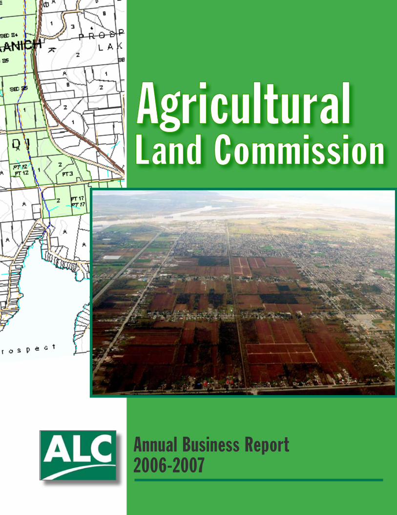
Annual Business Report 2006-2007
Library and Archives Canada Cataloguing in Publication DataBritish Columbia. Agricultural Land Commission.Agricultural Land Commission annual business report. – 2006/2007 –
AnnualISSN 1916-2294 = Agricultural Land Commission annual business report
1. British Columbia. Agricultural Land Commission – Periodicals. 2. Agricultural conservation – Government policy - British Columbia - Periodicals. 3. Land use, Rural – Government policy - British Columbia - Periodicals. I. Title. II. Title: Annual business report.
HD319.B7B74 354.3’434 C2007-960246-0
Contact Information:
Agricultural Land Commission 133-4940 Canada Way
Burnaby, BCV5G 4K6
www.alc.gov.bc.ca
�Agricultural Land Commission Annual Business Report, 2006-2007
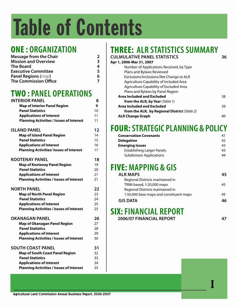
Table of ContentsONE : OrganizatiOnMessage from the Chair 2Mission and Overview 3The Board 4Executive Committee 5Panel Regions (map) 6The Commission Office 7
TWO : PanEL OPEratiOnSInTERIOR PanEl 8 MapofInteriorPanelRegion 9 PanelStatistics 10 ApplicationsofInterest 11 PlanningActivities/IssuesofInterest 11
Island PanEl 12 MapofIslandPanelRegion 14 PanelStatistics 15 ApplicationsofInterest 16 PlanningActivities/IssuesofInterest 17
KOOTEnay PanEl 18 MapofKootenayPanelRegion 19 PanelStatistics 20 ApplicationsofInterest 21 PlanningActivities/IssuesofInterest 21
nORTh PanEl 22 MapofNorthPanelRegion 23 PanelStatistics 24 ApplicationsofInterest 25 PlanningActivities/IssuesofInterest 25
OKanagan PanEl 26 MapofOkanaganPanelRegion 27 PanelStatistics 28 ApplicationsofInterest 29 PlanningActivities/IssuesofInterest 30
sOuTh COasT PanEl 31 MapofSouthCoastPanelRegion 32 PanelStatistics 33 ApplicationsofInterest 34 PlanningActivities/IssuesofInterest 35
ThrEE: aLr StatiSticS SummaryCulMulaTIvE PanEl sTaTIsTICs 36Apr1,2006-Mar31,2007 Number of Applications Received, by Type Plans and Bylaws Reviewed Exclusions/Inclusions/Net Change to ALR Agriculture Capability of Included Area Agriculture Capability of Excluded Area Plans and Bylaws by Panel Region AreaIncludedandExcluded 38 fromtheALR,byYear(Table 1) AreaIncludedandExcluded 39 fromtheALR,byRegionalDistrict(Table 2) ALRChangeGraph 40
FOUr: StratEgic PLanning & POLicy ConservationCovenants 41 Delegation 42 EmergingIssues 43 Establishing Larger Panels 43 Subdivision Applications 44
FIvE: maPPing & giS alR MaPs 45 Regional Districts maintained in TRIM-based, 1:20,000 maps 45 Regional Districts maintained in 1:50,000 base maps and constituent maps 45
gIs daTa 46
SIx: FinanciaL rEPOrt 2006/07 FInanCIal REPORT 47
�Agricultural Land Commission Annual Business Report, 2006-2007
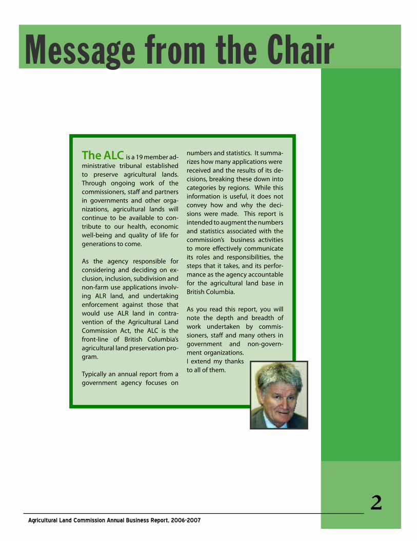
Message from the Chair
The alC is a 19 member ad-ministrative tribunal established to preserve agricultural lands. Through ongoing work of the commissioners, staff and partners in governments and other orga-nizations, agricultural lands will continue to be available to con-tribute to our health, economic well-being and quality of life for generations to come.
As the agency responsible for considering and deciding on ex-clusion, inclusion, subdivision and non-farm use applications involv-ing ALR land, and undertaking enforcement against those that would use ALR land in contra-vention of the Agricultural Land Commission Act, the ALC is the front-line of British Columbia’s agricultural land preservation pro-gram.
Typically an annual report from a government agency focuses on
numbers and statistics. It summa-rizes how many applications were received and the results of its de-cisions, breaking these down into categories by regions. While this information is useful, it does not convey how and why the deci-sions were made. This report is intended to augment the numbers and statistics associated with the commission’s business activities to more effectively communicate its roles and responsibilities, the steps that it takes, and its perfor-mance as the agency accountable for the agricultural land base in British Columbia.
As you read this report, you will note the depth and breadth of work undertaken by commis-sioners, staff and many others in government and non-govern-ment organizations. I extend my thanks to all of them.
�Agricultural Land Commission Annual Business Report, 2006-2007
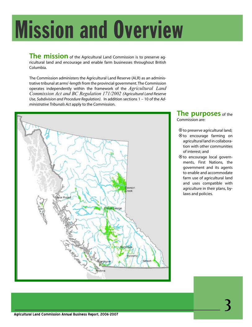
Mission and OverviewThe mission of the Agricultural Land Commission is to preserve ag-ricultural land and encourage and enable farm businesses throughout British Columbia.
The Commission administers the Agricultural Land Reserve (ALR) as an adminis-trative tribunal at arms’-length from the provincial government. The Commission operates independently within the framework of the Agricultural Land Commission Act and BC Regulation 171/2002 (Agricultural Land Reserve Use, Subdivision and Procedure Regulation). In addition sections 1 – 10 of the Ad-ministrative Tribunals Act apply to the Commission.
The purposes of the Commission are:
§to preserve agricultural land; §to encourage farming on
agricultural land in collabora-tion with other communities of interest; and §to encourage local govern-
ments, First Nations, the government and its agents to enable and accommodate farm use of agricultural land and uses compatible with agriculture in their plans, by-laws and policies.
�Agricultural Land Commission Annual Business Report, 2006-2007
The BoardThe agricultural land Commission is administered by a government-appointed Commission consisting of 19 board members comprised of a Chair, six Vice-Chairs and 12 Commissioners. For administrative efficiency and regional responsiveness the Commission has created 6 panels for its 6 geographical regions of the province. Each panel has three members - a Vice-Chair and 2 Commissioners ap-pointed from the region for which they are responsible.
The 19 member board is the provincial body of the Commission. The Commission is not, as is often thought, the aggregate of 6 regional Commissions.
The Board met once this fiscal year. Discussions included updates to the Service Plan, budget review, policy issues and operational issues including staffing and application processing.
Erik Karlsen, Victoria(Chair)
Michael Bose, Surrey (appointed Dec. 1, 2006)Holly Campbell, KamloopsDavid Craven, Shawnigan LakeGordon Gillette, Williams Lake (appointed Dec. 1, 2006)D. Grant Griffin, Cranbrook (appointed Dec. 1, 2006)Grant Huffman, Riske CreekSue Irvine, NaramataJohn Kendrew, Pouce CoupeMonika Marshall, Grand ForksSharon McCoubrey, Lake Country
William Norton, Chilako Valley near Prince George (appointed May 1, 2006)Sylvia Pranger, Kent (appointed Dec. 1, 2006)Carmen Purdy, CranbrookFrank Read, Vanderhoof Donald Rugg, ColwoodLorne Seitz, CourtenaySid Sidhu, VernonJohn Tomlinson, Langley (appointed May 1, 2006)
BOaRd MEMBERs (aPRIl 1, 2006 – MaRCh 31, 2007)
ThefollowingCommissionersalso served in this fiscal year until their terms expired in May 2006:Peter Dhillon, RichmondWalter Dyck, ChilliwackCheryle Huscroft, Creston
Harold Kerr, TelkwaCarol Paulson, Langley
ThE BOaRd
�Agricultural Land Commission Annual Business Report, 2006-2007
The panels consist of a Vice-Chair and 2 Com-missioners. Panels are responsible for:
§ Decisions on applications § Plan and bylaw reviews § Field inspections §Meeting with individuals, local gov-
ernments, farm organizations and other government representatives
Panels ThE PanEls Panels report their regional activities
through the Vice-Chair to the Executive Committee. All decisions relating to ap-plications and planning issues are made at the regional level by the panels. Deci-sions of a panel are final and cannot be appealed to the Executive Committee or the Board.
The Panels met on a regular rotation schedule depending on the application activity in their regions.
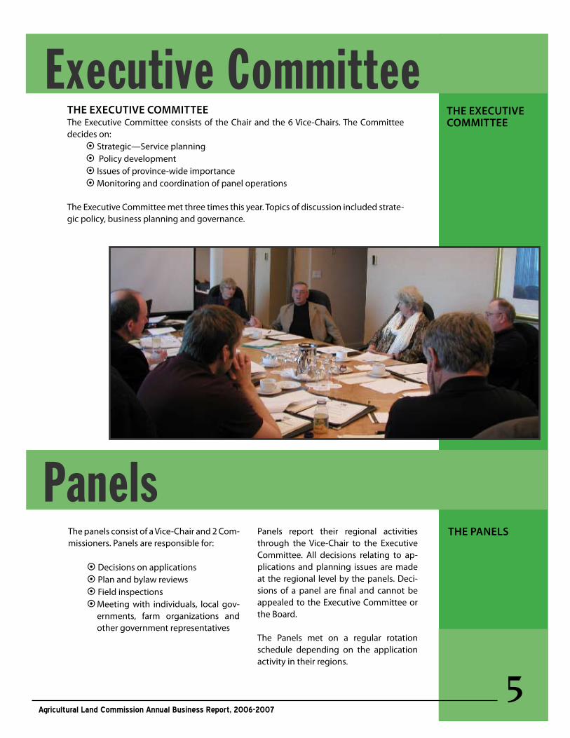
ThE ExECuTIvE COMMITTEEThe Executive Committee consists of the Chair and the 6 Vice-Chairs. The Committee decides on:§ Strategic—Service planning § Policy development § Issues of province-wide importance § Monitoring and coordination of panel operations
The Executive Committee met three times this year. Topics of discussion included strate-gic policy, business planning and governance.
ThE ExECuTIvE COMMITTEE
Executive Committee
�Agricultural Land Commission Annual Business Report, 2006-2007
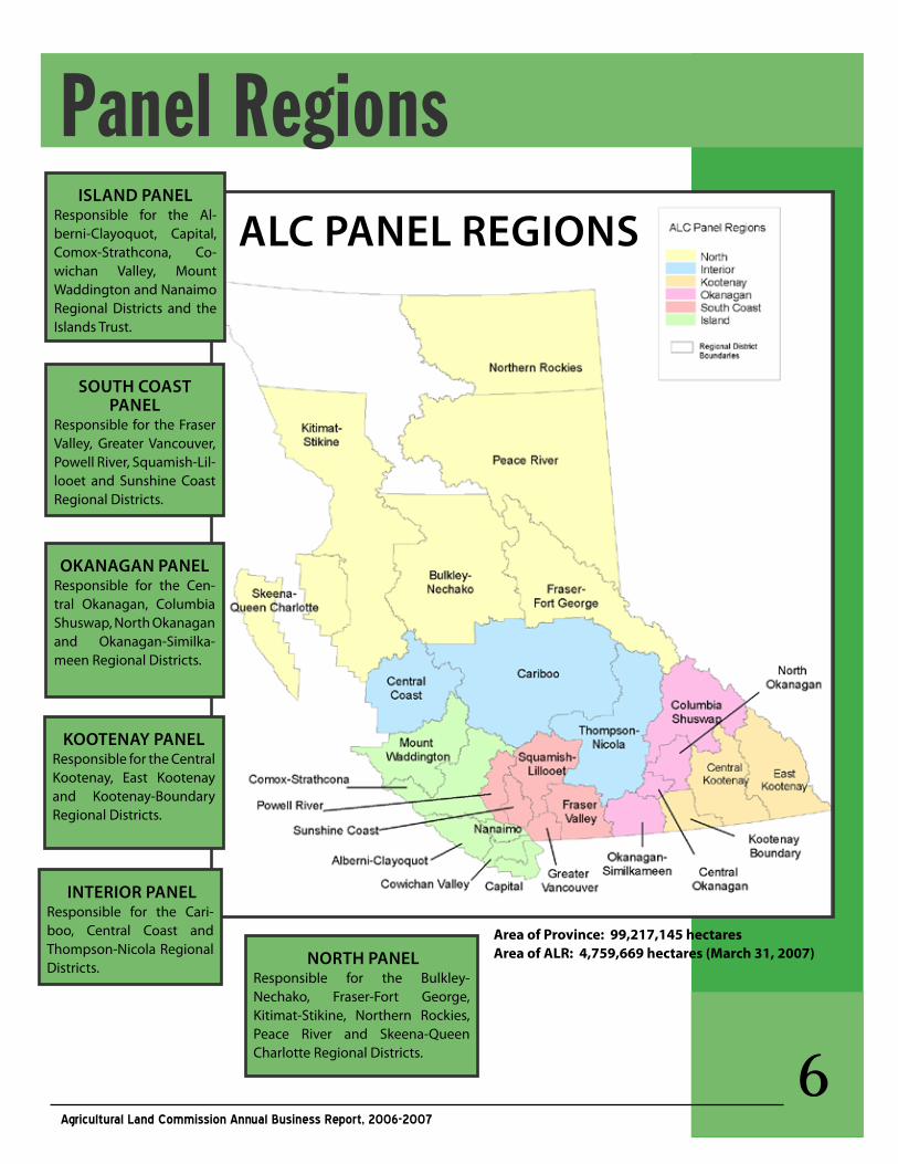
AreaofProvince:99,217,145hectaresAreaofALR:4,759,669hectares(March31,2007)
Panel RegionsIsland PanEl
Responsible for the Al-berni-Clayoquot, Capital, Comox-Strathcona, Co-wichan Valley, Mount Waddington and Nanaimo Regional Districts and the Islands Trust.
sOuTh COasT PanEl
Responsible for the Fraser Valley, Greater Vancouver, Powell River, Squamish-Lil-looet and Sunshine Coast Regional Districts.
OKanagan PanElResponsible for the Cen-tral Okanagan, Columbia Shuswap, North Okanagan and Okanagan-Similka-meen Regional Districts.
KOOTEnay PanElResponsible for the Central Kootenay, East Kootenay and Kootenay-Boundary Regional Districts.
InTERIOR PanElResponsible for the Cari-boo, Central Coast and Thompson-Nicola Regional Districts. nORTh PanEl
Responsible for the Bulkley-Nechako, Fraser-Fort George, Kitimat-Stikine, Northern Rockies, Peace River and Skeena-Queen Charlotte Regional Districts.
alC PanEl REgIOns
�Agricultural Land Commission Annual Business Report, 2006-2007
The Commission Office
ThE sTaFF
Executive DirectorsBrian Underhill Colin Fry
Policy and Special ProjectsGary Hall Shaundehl Runka
Compliance and EnforcementGordon Bednard
Staff AgrologistTrevor Murrie, P.Ag
Regional PlannersRoger Cheetham Island, Kootenay, North
Martin Collins Okanagan, Interior, North
Tony PellettSouth Coast
Land Use PlannersJennifer CarsonSouth Coast
Terra Kaethler Island, Kootenay
Brandy RidoutOkanagan
Simone RiversInterior, North
Mapping and GISStacy MeechGIS Coordinator
Craig PhillipsMapping Technician
Gabriel HazaparuMapping Technician
Administrative SupportEva GermanoReception
Lesley Campbell Records Clerk
Myra Duggan Accounts
Lucena Varias CondevillamarWord Processing Clerk
The Commission employed 20 staff this past year. The business of the Commission is carried out through three functional areas:
LandUsePlanningandApplicationProcessingStaff research and administer all applications submitted pursuant to the Agricultural Land Commission Act and Regulations as well as performing compliance and enforcement related duties. In addition, they also review plans and by-laws of local governments and other agencies to ensure that the ALR is properly identified and that the policies support the objectives of the Act and Regulations.
StrategicPlanningandCorporatePolicyStaff actively participates with the Commission in developing strategies, plans and policies to achieve the goals and objectives set out in the Service Plan. Staff also participates in the agricultural planning and policy initiatives of other ministries, agencies and local governments.
AdministrationandInformationSystemsThe previous two functions are supported by an administration, records management and informa-tion systems unit. This includes maintenance of an application database comprised of approximately 29,000 stored paper files and almost 9,000 stored paper and electronic files as well as over 1,400, 1:20,000 scale ALR maps for the province.
�Agricultural Land Commission Annual Business Report, 2006-2007
Message from the Vice-Chair
The Interior Panel of the Agricultural Land Com-mission administers the ALR lying between Kamloops and Quesnel. This is the ranching belt of British Columbia. In recent years, cattle ranching has been under economic pressure due to the BSE crisis. While this crisis appears to be easing, the economic stresses brought about by cattle export restrictions in past years continues to reverberate throughout the region. Established ranches are under pressure to diversify income or access equity in ranch properties. In addition there are constant pressures on ranching lands from urbanites seek-ing land for recreational and residential uses.
The Interior Panel reviewed 59 new applications for subdivision, exclusion and non-farm use in 2006/2007. Applications are characterized by exclusion or subdivision of larger grazing/range parcels adjoining; major highways for commercial/industrial uses (in select locations); and lakes for residential uses. The Panel takes the view that on occasion benefits can be achieved for agriculture when multiple parcels are under application. For example, owners may have the option to consoli-date farm remnants to at least balance the effects
of subdivision, exclusion or non-farm use and more preferably, to enhance the agricultural utility of the land.
The use of large grazing parcels exclusively for resi-dential uses, can degrade the grassland resource, and result in residential/farm conflicts and a patch-work, discontinuous, non-working landscape. The Commission is working with ranchers and land-owners to minimize the impact of residential uses on the working landscape.
Transportation corridors on scarce valley bottom land may represent a significant loss of the high-est capability agricultural land in the region. These lands are also under pressure for recreational uses (golf courses and playing fields), as well as commercial and industrial uses associated with transportation infrastructure.
Interior PanelPANEL OPERATIONS
MEMBERs: Grant Huffman (Vice-Chair),
Holly Campbell, Gordon Gillette
�Agricultural Land Commission Annual Business Report, 2006-2007
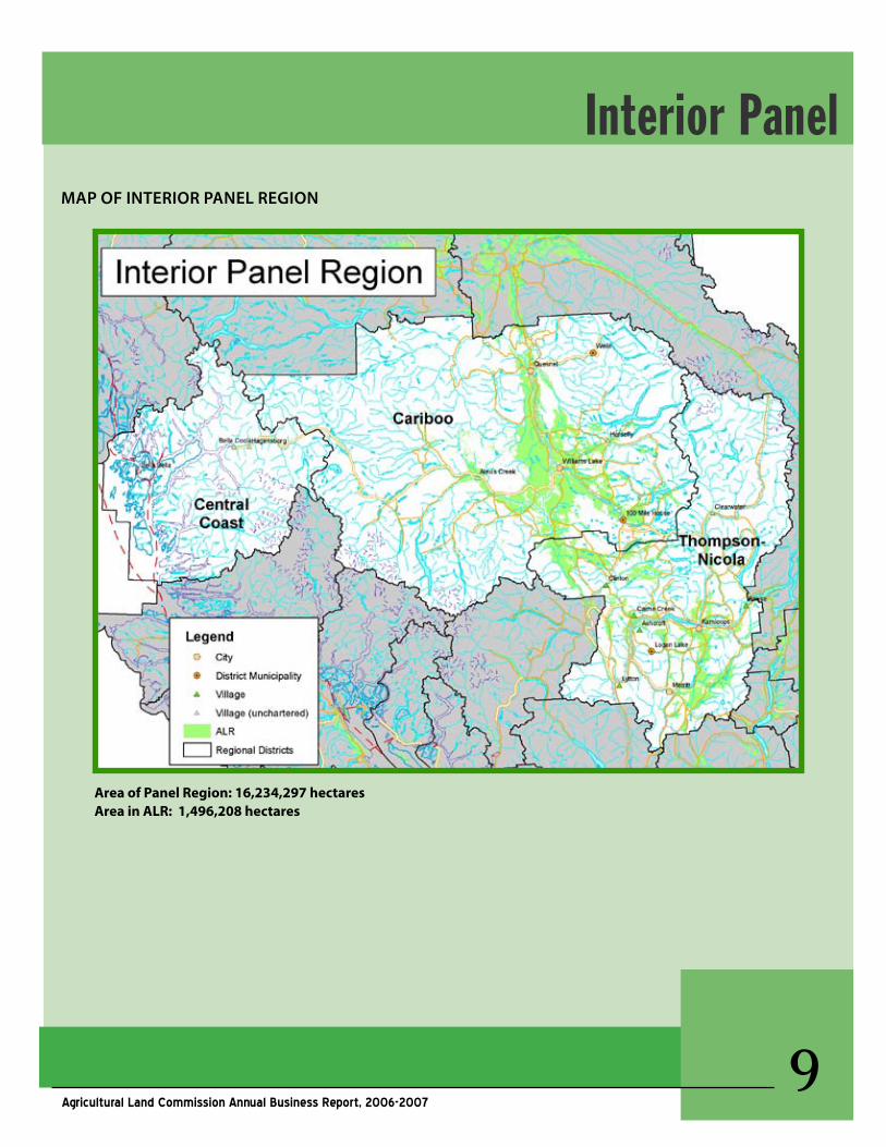
MaP OF InTERIOR PanEl REgIOn
Interior Panel
AreaofPanelRegion:16,234,297hectaresAreainALR:1,496,208hectares
�0Agricultural Land Commission Annual Business Report, 2006-2007
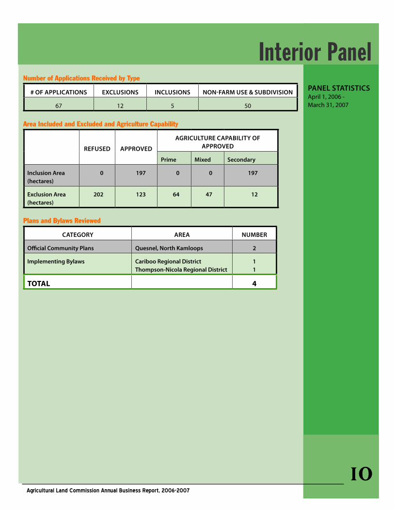
Number of Applications Received by Type
# OF aPPlICaTIOns ExClusIOns InClusIOns nOn-FaRM usE & suBdIvIsIOn
67 12 5 50
Area Included and Excluded and Agriculture Capability
REFusEd aPPROvEd
agRICulTuRE CaPaBIlITy OF aPPROvEd
Prime Mixed secondary
Inclusion area(hectares)
0 197 0 0 197
Exclusion area (hectares)
202 123 64 47 12
Plans and Bylaws Reviewed
CaTEgORy aREa nuMBER
Official Community Plans Quesnel, north Kamloops 2
Implementing Bylaws Cariboo Regional district Thompson-nicola Regional district
11
TOTAL 4
PanEl sTaTIsTICs April 1, 2006 - March 31, 2007
Interior Panel
��Agricultural Land Commission Annual Business Report, 2006-2007
aPPlICaTIOns OF InTEREsTThe following selected examples illustrate how the Agricultural Land Commission panels responded to proposals to change the ALR boundary or to requests for subdivision or non-farm use of ALR lands. Applications are considered on the merits of each case at hand in the context of the Commission’s mandate and take into account an assessment of fac-tors related to agricultural capability and suitability and impact upon the ALR.
British Columbia Wilderness Tours Inc. (Tranquille)#ZZ-36735The application was to exclude from the ALR, 47 ha in Kamloops to build 320 single-family homes, 950 multi-family homes, 20,000 ft2 of commercial space and to use 46.1 ha in the ALR for a golf course. The former Tranquille Health Care Institution is located on the property which includes approximately 100 abandoned structures.
In its review, the Interior Panel noted that in 1989, approval had been given to the then Ministry of Crown Lands to exclude 32 ha of land that encompassed the health facility and to use 10 ha for recreational use provided the recreational use did not encroach on adjacent agricultural land. The land was never excluded because the required fence and buffer were not established.
In July 2006 the application was refused as proposed. However, in light of the 1989 de-cision the Panel indicated it was prepared to consider a revised proposal that benefited agriculture by more efficiently configuring agricultural fields and designing the urban uses and infrastructure in such a way as to not intrude on or impact the agricultural area of the property.
Commission staff subsequently worked with the proponent and a revised proposal was reviewed by the Panel February 2007. The revised develop-ment proposal was approved as the Panel believed that overall, the suitability of the ALR lands for farm use would be preserved, and in some cases improved, and that the impact of the proposed non-farm uses would be mitigated and contained. The Panel required the development to proceed in phases to ensure the agricultural improvements associated with the project would be substantially completed in phase one. Agricultural improve-ments include the consolidation of the agricultural area into a single parcel, upgrading the irrigation infrastructure, securing water rights, repairing and constructing fences and vegetative screening, rec-lamation of debilitated lands associated with the Tranquille facility by removing derelict buildings and soil remediation.
PlannIng aCTIvITIEs / IssuEs OF InTEREsTThe following selected example illustrates how the integration and coordination of interests regard-ing land use planning and resource management require ongoing dialogue and collaboration between local governments and the Agricultural Land Commission.
In 2006/07, the Panel encouraged agricultural development and reclamation of debilitated lands comprising the historic Tranquille site located on Kamloops Lake in the westerly part of the City of Kamloops. In response to an application for housing and a resort in the ALR, the Commission directed development away from high capability lands, required the agricultural development of fallow lands, and reclamation of previously de-bilitated lands to agricultural uses, resulting in a benefit for agriculture. It is the Commission’s view that by working cooperatively with the proponent and the City from a land use planning perspective, agricultural values were addressed.
aPPlICaTIOns OF InTEREsT
PlannIngaCTIvITIEs / IssuEs OF InTEREsT
Interior Panel
��Agricultural Land Commission Annual Business Report, 2006-2007
Message from the Vice-Chair
During the past year, pressure on the Agriculture Land Reserve on Vancouver Island subsided to a degree. The number of applications considered by the Island Panel was down 23% (from 88 to 68) compared to the previous year. While growth con-tinues at a brisk pace on the south east side of the Island, that did not translate into increased pres-sure on the ALR.
A number of exclusions of land from the ALR were approved in the last year but, in most cases, the land was of relatively poor quality for agriculture. In two instances, the ALR boundary was adjusted to include adjacent lands that were of equal or better quality than the lands excluded. These situ-ations indicate that the mapping of the ALR is not perfect.
Many of the applications considered by the Island Panel in the past year were for subdivision of land. These applications were not for dense housing subdivision but usually would involve dividing a property, frequently not currently farmed, into two or more smaller units, which would remain in the ALR. There are a number of issues that arise with subdivision requests and each application has its own unique set of circumstances. In some instances, topographical characteristics, such as streams, gullies, ridges or roads create significant challenges to farming the property as a single unit. In other cases, subdivision might create two, more viable, farm units, might assist in the intergen-erational transfer of the farm operation or might allow for children to become a full participant in a large farming operation. The Commissioners must consider all the factors associated with an applica-tion. We have found site visits and discussion with applicants extremely beneficial in reaching a deci-sion.
The Island Panel has noted an increase in the num-ber of subdivision applications where the intent is to plan for estate settlement or to provide a lot for
a child with no obvious agriculture objective. The Commission has not considered these to be suf-ficient reasons for subdivision. In these cases, the Commissioners revert to consideration of whether there are valid agriculture reasons for dividing the property or whether topographical or other similar characteristics would support subdivision.
The Panel also noted that, generally, local gov-ernments are becoming more supportive of agriculture. The Panel reviewed several Official Community Plans over the past year and invariably the OCPs recognized agriculture as an important component of the local community and economy. We had a number of fruitful discussions with local governments throughout the year. These observa-tions suggest that local governments are looking carefully at maximizing the use of lands outside of the ALR before approaching the Panel request-ing assistance in addressing some of their growth challenges.
During the past year, there has been an increased media focus on the ALR and the Commission. This increased attention has had a positive benefit in that it has heightened public awareness of the im-portance of agriculture and the value of the ALR.
However, in several instances, the information presented has not told the complete story. Two examples are illustrative. The first is reference to the amount of land excluded from the ALR on Van-couver Island since 2002, particularly in the Capital Region District (CRD). These references argue that a significant amount of land has been excluded from the ALR. What is usually not mentioned is that during this same period land has been added to the ALR. In all, while just under 1,300 hectares were removed from the ALR the Panel also includ-ed approximately 540 hectares into the ALR.
With regard to the area excluded from the ALR it is important to note several significant applica-
Island Panel Members: Lorne Seitz (Vice-Chair),
David Craven, Donald Rugg
PANELOPERATIONS
Continued on next page...
��Agricultural Land Commission Annual Business Report, 2006-2007
tions. The federal government required the exclusion of 429 hectares to create the Gulf Islands National Park. The federal government would not take ownership of the land unless all encumbrances on title (including the ALR designation) were removed. Refusal to remove the land from the ALR could have caused the agreement to create the National Park to collapse. An additional 100 hectares were excluded to facilitate the expansions of Royal Roads University, Camosun College and Swartz Bay Ferry Terminal while another 70 hectares involved the exclusion of the land occupied by the terminal and runway of the Campbell River Airport. These applications account for 47 % of all land excluded from the ALR between April 1, 2002 and March 31, 2007.
The second example is a map of the CRD pro-duced by the Sierra Club. It shows the lands excluded from the ALR since it was established in 1974. The lands excluded for the Gulf Is-lands National Park and Royal Roads are shown with no explanation or analysis. In addition, the maps identify 426 hectares of the ALR oc-cupied by golf courses. What is not stated is that almost all of that land was occupied by the golf courses before the ALR was estab-lished. Included in this group are the Victoria and Uplands Golf Courses in Oak Bay and the Royal Colwood Golf Course in Colwood. These courses preceded the establishment of the ALR by up to 100 years. In 1974, most golf courses were placed in the ALR, presumably based on the premise that, if required, they could be
converted to agriculture production. Unfor-tunately, unless they are familiar with these details, most readers would assume that the lands were made available for golf course de-velopment after the ALR was established.
While 2006 was a relatively quiet year on Vancouver Island, the Commission cannot assume that trend will continue. Growth on the south east coast of the Island will con-tinue and pressure on the ALR will increase. Close cooperation between the ALC and local governments will help to channel the growth pressure to non-ALR land within developed areas. To achieve that, local governments will have to increase densities to minimize sprawl.
Nevertheless, there will still be pressure on the ALR, particularly to accommodate the infrastructure needs of growing communi-ties. This might involve new or expanded roads, new regional transit, water and sewer facilities, recreation areas, schools and hos-pitals. In some instances, it will be difficult for communities to meet these growth chal-lenges without an impact on the ALR. The Commission will, of necessity, be required to work closely with local governments to find solutions that minimize the impact on the ALR and attempt to identify compensating benefits for agriculture in the communities.
Continued from previous page...
Island Panel
��Agricultural Land Commission Annual Business Report, 2006-2007
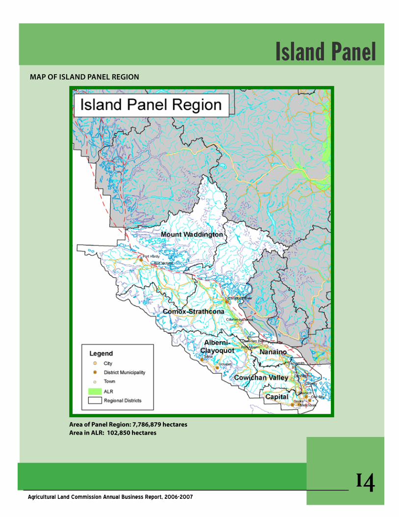
MaP OF Island PanEl REgIOn
Island Panel
AreaofPanelRegion:7,786,879hectaresAreainALR:102,850hectares
��Agricultural Land Commission Annual Business Report, 2006-2007
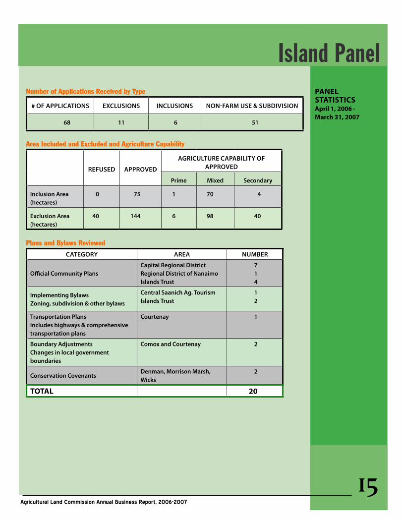
PANELSTATISTICSApril1,2006-March31,2007
Number of Applications Received by Type
# OF aPPlICaTIOns ExClusIOns InClusIOns nOn-FaRM usE & suBdIvIsIOn
68 11 6 51
Area Included and Excluded and Agriculture Capability
REFusEd aPPROvEd
agRICulTuRE CaPaBIlITy OF aPPROvEd
Prime Mixed secondary
Inclusion area(hectares)
0 75 1 70 4
Exclusion area (hectares)
40 144 6 98 40
Plans and Bylaws Reviewed
CaTEgORy aREa nuMBER
Official Community PlansCapital Regional districtRegional district of nanaimoIslands Trust
714
Implementing BylawsZoning, subdivision & other bylaws
Central saanich ag. TourismIslands Trust
12
Transportation Plans Includes highways & comprehensive transportation plans
Courtenay 1
Boundary adjustmentsChanges in local government boundaries
Comox and Courtenay 2
Conservation Covenantsdenman, Morrison Marsh, Wicks
2
TOTAL 20
Island Panel
��Agricultural Land Commission Annual Business Report, 2006-2007
aPPlICaTIOns OF InTEREsT
The following selected example(s) illustrate how the Agricultural Land Commission panels responded to proposals to change the ALR bound-ary or to requests for subdivision or non-farm use of ALR lands. Applications are considered on the merits of each case at hand in the context of the Commission’s mandate and take into account an assessment of factors related to agricultural capa-bility and suitability and impact upon the ALR.
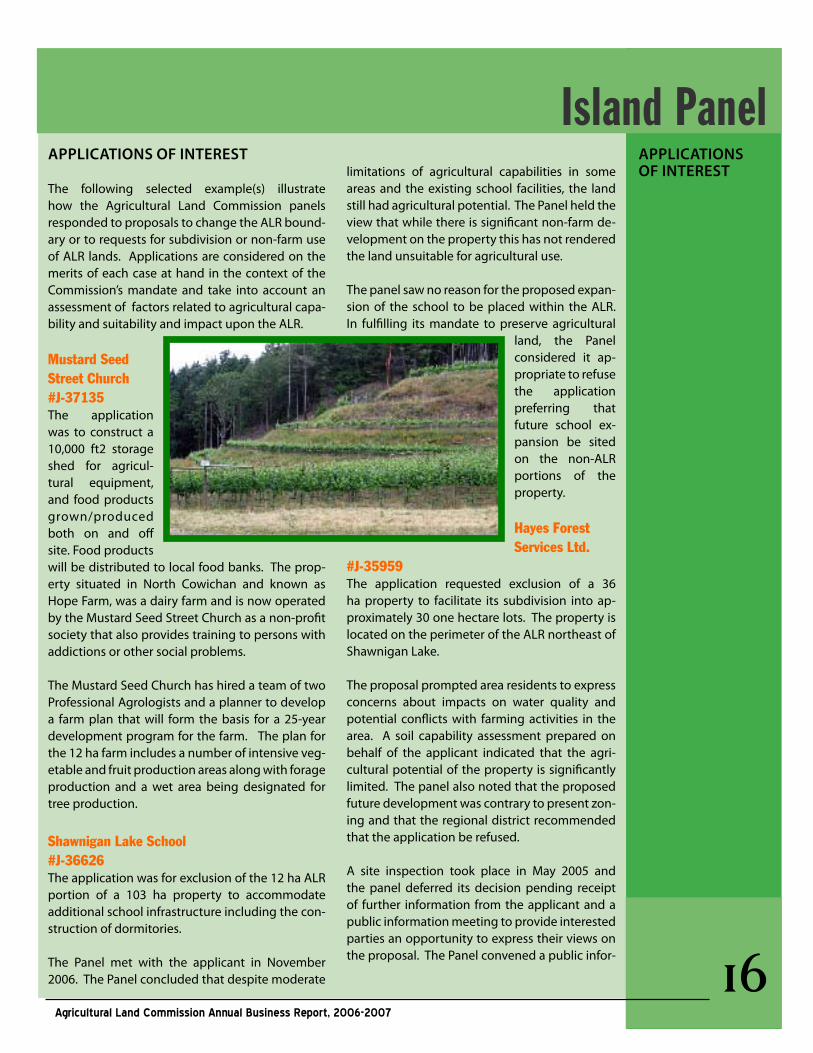
Mustard Seed Street Church#J-37135The application was to construct a 10,000 ft2 storage shed for agricul-tural equipment, and food products grown/produced both on and off site. Food products will be distributed to local food banks. The prop-erty situated in North Cowichan and known as Hope Farm, was a dairy farm and is now operated by the Mustard Seed Street Church as a non-profit society that also provides training to persons with addictions or other social problems.
The Mustard Seed Church has hired a team of two Professional Agrologists and a planner to develop a farm plan that will form the basis for a 25-year development program for the farm. The plan for the 12 ha farm includes a number of intensive veg-etable and fruit production areas along with forage production and a wet area being designated for tree production.
Shawnigan Lake School#J-36626The application was for exclusion of the 12 ha ALR portion of a 103 ha property to accommodate additional school infrastructure including the con-struction of dormitories.
The Panel met with the applicant in November 2006. The Panel concluded that despite moderate
aPPlICaTIOns OF InTEREsTlimitations of agricultural capabilities in some
areas and the existing school facilities, the land still had agricultural potential. The Panel held the view that while there is significant non-farm de-velopment on the property this has not rendered the land unsuitable for agricultural use.
The panel saw no reason for the proposed expan-sion of the school to be placed within the ALR. In fulfilling its mandate to preserve agricultural
land, the Panel considered it ap-propriate to refuse the application preferring that future school ex-pansion be sited on the non-ALR portions of the property.
Hayes Forest Services Ltd.
#J-35959The application requested exclusion of a 36 ha property to facilitate its subdivision into ap-proximately 30 one hectare lots. The property is located on the perimeter of the ALR northeast of Shawnigan Lake.
The proposal prompted area residents to express concerns about impacts on water quality and potential conflicts with farming activities in the area. A soil capability assessment prepared on behalf of the applicant indicated that the agri-cultural potential of the property is significantly limited. The panel also noted that the proposed future development was contrary to present zon-ing and that the regional district recommended that the application be refused.
A site inspection took place in May 2005 and the panel deferred its decision pending receipt of further information from the applicant and a public information meeting to provide interested parties an opportunity to express their views on the proposal. The Panel convened a public infor-
Island Panel
��Agricultural Land Commission Annual Business Report, 2006-2007
mation meeting in January 2007.
The Panel concluded that for the most part the land had marginal agricultural capabil-ity. In agreeing to exclude the majority of the land, the Commission recognized that there was an active farming operation be-yond the north east corner of the property on higher capability soils and that this was a concern raised at the public meeting. Therefore, the Panel excluded the property save and except the north east portion so as not to negatively impact the adjacent farm.
PlannIng aCTIvITIEs / IssuEs OF InTEREsTThe following selected example illustrates how the integration and coordination of interests regarding land use planning and resource management require ongoing dialogue and collaboration between local governments and the Agricultural Land Commission.
In 2006/07 the Panel had the opportu-nity to review and provide feedback on a number of community planning and land use bylaw matters. These matters were of interest to the Commission because they were all generally very supportive of farming and the ALR. Most of the plan-ning-related business was focused in and around the Capital Regional District and presented few if any issues that the Com-mission considered as contrary to the intent and purpose of the Agricultural Land Commission Act.
PlannIng aCTIvITIEs/ IssuEs OF InTEREsT
Island Panel
��Agricultural Land Commission Annual Business Report, 2006-2007
Message from the Vice-Chair
The Panel experienced continuing pressure on the ALR for resort develop-ment during the year, particularly in the East Kootenay area. This pressure and the on-going difficulties being experienced in the ranching sector highlighted two important issues:
§ The need to identify the key issues affecting the future of agri-culture in the region and review the ALR in the light of these issues, and
§ The importance of working with the regional district and stake-holder groups to develop a new land use strategy for the Columbia Trench that reflects the needs of the agriculture community in light of the pressures from the resort and development sectors.
In recent years the Panel has had a growing concern with regard to the number of conservation covenants that propose to significantly restrict agricultural activity. During this past year three such covenants were re-viewed by the Panel none of which were approved. Discussions were held during the year with conservation groups to explain that without proper consideration of agricultural values, the registration of conservation cov-enants can significantly impact the agricultural economy in the Kootenays. While respecting the overall objectives of conservation covenants the Panel does not believe they should be used to eliminate or significantly restrict agriculture. More discussion is needed in this regard.
Kootenay PanelPanEl OPERaTIOns
Members: Monika Marshall (Vice-Chair),
Carmen Purdy, D. Grant Griffin
��Agricultural Land Commission Annual Business Report, 2006-2007
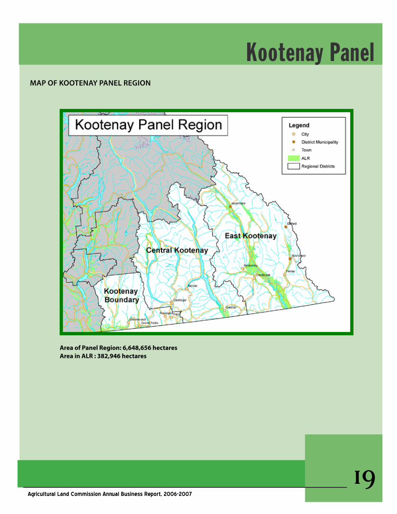
MaP OF KOOTEnay PanEl REgIOn
Kootenay Panel
AreaofPanelRegion:6,648,656hectaresAreainALR:382,946hectares
�0Agricultural Land Commission Annual Business Report, 2006-2007
PANELSTATISTICSApril1,2006-March31,2007
Kootenay Panel Number of Applications Received by Type
# OF aPPlICaTIOns ExClusIOns InClusIOns nOn-FaRM usE & suBdIvIsIOn
103 14 1 88
Area Included and Excluded and Agriculture Capability
REFusEd aPPROvEdagRICulTuRE CaPaBIlITy OF
aPPROvEd
Prime Mixed secondary
Inclusion area(hectares)
0 1 0 0 1
Exclusion area (hectares)
5 353 0 259 94
Plans and Bylaws Reviewed
CaTEgORy aREa nuMBER
Official Community Plans
Regional district of Kootenay BoundaryRegional district of East Kootenay
13
Implementing BylawsZoning, subdivision & other bylaws
Kimberley 1
utility and Energy Projectsutility & infrastructure corridors
Waneta Expansion Project 1
Boundary adjustmentsChanges in local government boundaries
Cranbrook 1
Conservation Covenants Regional district of East Kootenay
3
TOTAL 10
��Agricultural Land Commission Annual Business Report, 2006-2007
APPLICATIONSOfINTEREST
PLANNINGACTIvITIES/ISSUESOfINTEREST
APPLICATIONSOfINTERESTThe following selected examples illustrate how the Agricultural Land Commission panels responded to proposals to change the ALR boundary or to requests for subdivision or non-farm use of ALR lands. Applications are considered on the merits of each case at hand in the context of the Commission’s mandate and take into account an assessment of factors related to agricultural capability and suitability and impact upon the ALR.
Braund#L-36540
In September 2006, the Panel considered a proposal on land near Windermere Lake, to develop a private, not for profit, 18-hole golf course facility on a portion of two properties totaling 164 ha.
The Panel toured the property and met with the applicant and agent in June 2006. It was noted the property is an operating ranch. In the Panel’s view, the land had agricultural capability and it did not believe that there were external factors that rendered the land unsuit-able for agricultural use. The Panel was also concerned that the proposal would negatively impact existing or potential agricultural use of the subject property and surrounding lands in the long term. The application was denied.
Waneta Expansion Power Corporation#Q-36529
This application was part of the Waneta Hydro-Electric Expansion Project requiring ap-proximately 9.8 km of new transmission line to be constructed to connect the Waneta Dam Ex-pansion Power Plant to the Selkirk substation. The majority of the new transmission line was
to be located on Crown or private land outside of the ALR with the exception of a 1.5 ha area near Castlegar.
The Panel visited the site of the proposed trans-mission line in May 2006 and found that there are some pasture lands and existing hay fields that have already been impacted by two existing utility corridors in the vicinity. In the Panel’s view, this aspect of the proposal, as it affects the ALR, was an essential part of the overall project which was benefiting the region as a whole. The Panel believed that the transmission line within the ALR would not alter or hinder the existing farm activities in the vicinity provided adequate mea-sures were taken to prevent the spread of noxious weeds.
PlannIng aCTIvITIEs / IssuEs OF InTEREsTThe following selected example illustrates how the integration and coordination of interests regard-ing land use planning and resource management require ongoing dialogue and collaboration between local governments and the Agricultural Land Commission.
The Panel has, in recent years, noticed a sig-nificant increase in the number of applications coming from the East Kootenay area for resort and residential development within the ALR. This to-gether with the difficulties being experienced by the ranching industry has prompted the Panel to engage the regional district in planning processes that incorporate specific strategies for preserving agricultural land, bring additional agricultural land into production, and which strengthen the regional agricultural economy. The Commission has accordingly added this objective to its service plan for the period 2007/2010.
Kootenay Panel
��Agricultural Land Commission Annual Business Report, 2006-2007
Message from the Vice-Chair
The Panel was extremely busy during the past year administering an extensive geographic area ranging from Terrace to Valemount (west to east) and Prince George to Fort Nelson (south to north). The Panel administers the largest ALR area in the province, constituting approximately 2.3 million hectares of ALR, about half the provincial total.
The Panel reviewed 123 applications in 2006/07, among the highest of each of the 6 panels. After resolving a number of outstanding issues at a meeting held between the Panel and the Regional District Fraser-Fort George, it was able to endorse the Pineview and Robson Valley Canoe Upstream of-ficial community plans bringing the entire Regional District (7 electoral areas) under delegated decision making. The agreement has now been in place for 6 years. An audit of the Regional District’s decisions under the agreement was conducted by the Panel during the year which suggests the agreement is working satisfactorily.
In 2006 the Panel conditionally endorsed the South Peace Comprehensive Development Plan (CDP), which laid the groundwork for the expansion of the City of Dawson Creek. The CDP followed the template of Fort St John and Area CDP, which was
PanEl OPERaTIOns
North Panel
adopted in 2003/2004. Dawson Creek is undergoing an oil and gas exploration boom that is stretching its urban fabric. Other planning initiatives in the northeast include the adoption of the Fort Nelson Official Community Plan and the proposed Fort St John Fringe Official Community Plan.
The potential to delegate decision making au-thority to other regional districts will be explored. Extensive ALR areas and agriculturally supportive OCPs and zoning bylaws in the north may provide further opportunities for delegation.
Subdivision for a family member is an issue, as farmers seek to retain family members on farm properties to facilitate intergenerational transfers of assets and farmland. The Panel continues to take into account biophysical criteria, productive capacity of the land, and conflict potential when its reviews subdivision applications for relatives.
Oil and gas exploration on ALR land remains a source of friction between farmers and exploration and extraction companies. The Panel is working with the Oil and Gas Commission to ensure that agricultural values are protected to the greatest extent possible.
Members: Frank Read (Vice-Chair),
John Kendrew, William Norton
��Agricultural Land Commission Annual Business Report, 2006-2007
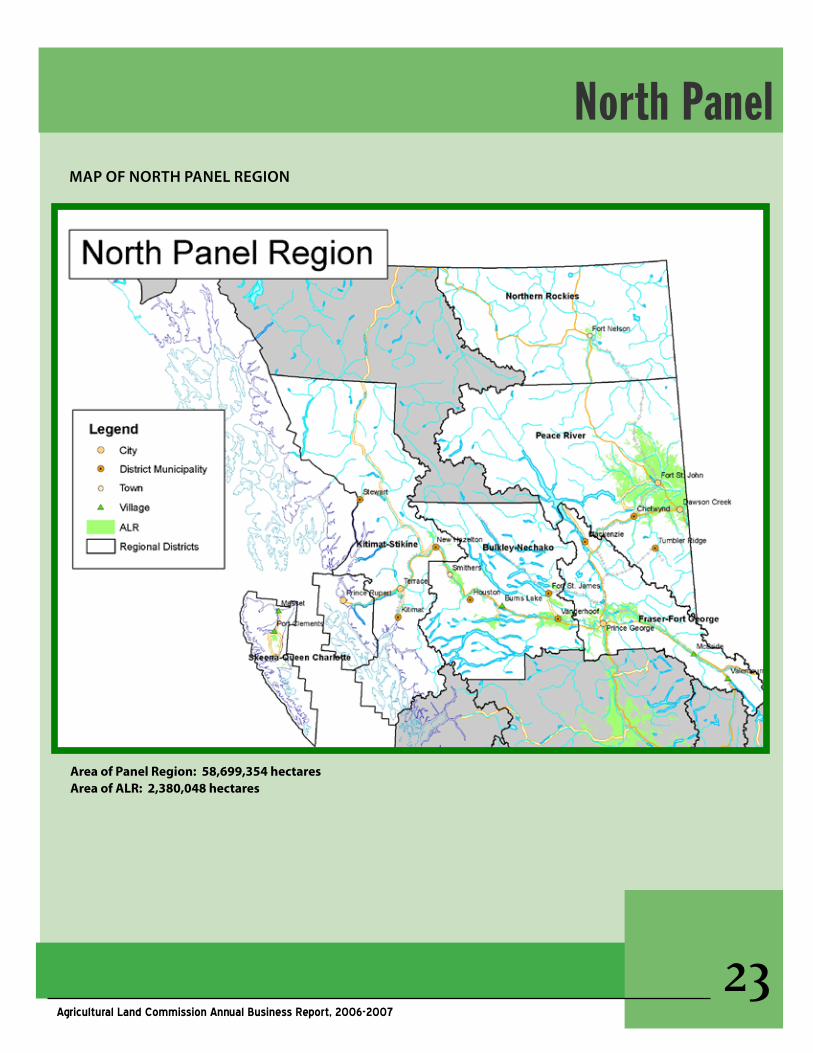
North Panel
AreaofPanelRegion:58,699,354hectaresAreaofALR:2,380,048hectares
MaP OF nORTh PanEl REgIOn
��Agricultural Land Commission Annual Business Report, 2006-2007
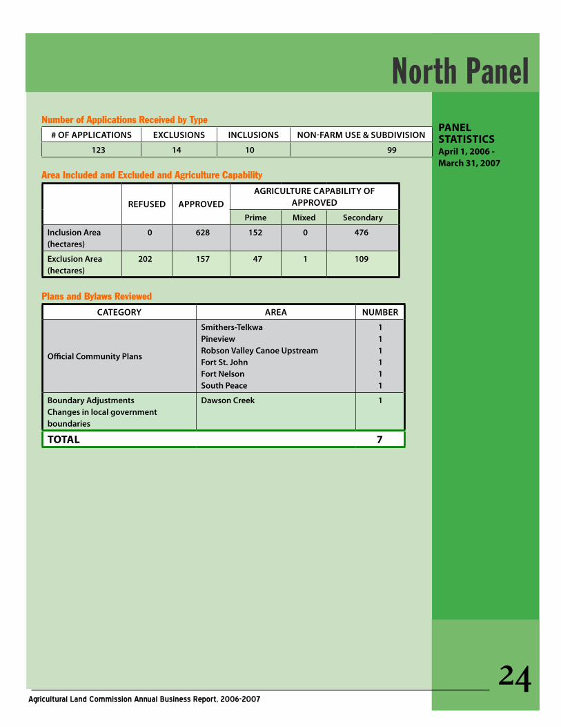
PANELSTATISTICSApril1,2006-March31,2007
Number of Applications Received by Type # OF aPPlICaTIOns ExClusIOns InClusIOns nOn-FaRM usE & suBdIvIsIOn
123 14 10 99
Area Included and Excluded and Agriculture Capability
REFusEd aPPROvEdagRICulTuRE CaPaBIlITy OF
aPPROvEd
Prime Mixed secondary
Inclusion area(hectares)
0 628 152 0 476
Exclusion area (hectares)
202 157 47 1 109
Plans and Bylaws Reviewed
CaTEgORy aREa nuMBER
Official Community Plans
smithers-Telkwa Pineview Robson valley Canoe upstreamFort st. JohnFort nelsonsouth Peace
111111
Boundary adjustmentsChanges in local government boundaries
dawson Creek 1
TOTAL 7
North Panel
��Agricultural Land Commission Annual Business Report, 2006-2007
aPPlICaTIOns OF InTEREsTThe following selected example illustrates how the Agricultural Land Commission panels responded to proposals to change the ALR boundary or to requests for subdivision or non-farm use of ALR lands. Applications are considered on the merits of each case at hand in the context of the Commission’s mandate and take into account an assessment of factors related to agricultural capa-bility and suitability and impact upon the ALR.
Teed#W-36751
The application was to exclude a 19 ha portion of the 49 ha property from the ALR for light industrial development. If excluded, the area was to be sub-divided into approximately four 4.8 ha lots.
The property is part of a large block of land in and around Fort St. John that has been identified through a comprehensive planning and develop-ment process for future community development. In 2003, the Panel working with the Peace River Regional District, endorsed certain aspects of the Fort St. John and Area Comprehensive Develop-ment Plan (CDP), which provided an identified land supply for future growth in the region over the next 20 years. In light of the CDP, the Regional District and the Panel have been entertaining applications and dealing with them in a manner consistent with the CDP’s land use policies, desig-nations and phasing plans.
The Panel found the Teed application to be consis-tent with the long-term objective of the CDP but it was identified by the Regional District as being
within Phase 3 and therefore not part of current planning objectives. In July 2006, the Panel, fol-lowing a close review of all of the factors affecting the application, including a meeting with the proponent decided to refuse the application. In making this decision, the Panel noted that it was premature to consider approving the application in light of its endorsement of the CDP and in ad-vance of the substantial completion of Phases 1 and 2.
PlannIng aCTIvITIEs / IssuEs OF InTEREsTThe following selected example illustrates how the integration and coordination of interests regard-ing land use planning and resource management require ongoing dialogue and collaboration be-tween local governments and the Agricultural Land Commission.
In 2006/07, the Panel, the Peace River Regional District and the City of Dawson Creek concluded a collaborative land use planning exercise that addressed the growth pressures experienced by the City. The Commission did not agree with the Regional District’s original proposal for the South Peace Comprehensive Development Plan, believ-ing it to be too ambitious, and inconsistent with its mandate. However, following a land use analy-sis that assessed growth rates and the existing vacant land inventory, the Commission reduced and re-directed the original land use designation proposal by Dawson Creek for ALR land for com-mercial, industrial and residential development to areas less suitable for agriculture.
North PanelaPPlICaTIOns OF InTEREsT
PlannIng aCTIvITIEs /IssuEs OF InTEREsT
��Agricultural Land Commission Annual Business Report, 2006-2007
Message from the Vice-Chair Many Okanagan Valley communities are con-strained by the ALR. During 2006/07, the Panel has been frequently petitioned by urban communities seeking places to grow. A sig-nificant portion of Panel time has been spent meeting and discussing urban growth options with local communities as it relates to the ALR. Many communities are facing a strong demand for retirement and recreational residences. Also there are specific local pressures on lands for industry and commerce. These lands are deemed essential for Okanagan communities in order to balance and/or enhance the work/resident ratio, and to ensure complete communities with a mix of ages, jobs and services. At the same time, the agricultural sector is seeking affordable land on which to expand. Intense residential development pressures have contributed to the significantly increasing price of farmland rising beyond the means of many farmers. The Panel has been in discussions within the past year with the Town of Osoyoos, the District of Sicamous, the Town of Oliver and the Regional District of Central Okanagan (re: Westbank) about accommodating urban growth pressures in the ALR. Each community is surrounded by the ALR. The Panel takes the general approach that incremental expansion of urban areas into the ALR cannot be sustained in the long term and encourages local governments to approach these pressures on a regional basis, and to directing urban growth to communities with the capacity to absorb growth. Councils are also encouraged to consider what benefits for agriculture can be achieved through community investment or planning processes. In general, the Panel has been able to successfully work with communities to achieve a balanced re-sponse to urban pressures that respects the purposes of the Agricultural Land Commission Act. However,
it continues to caution mayors and councils that it may not accede to urban pressures in some areas, believing that expansion onto farmlands must cease to be an option in the face of current biophysical and cultural realities supporting the necessity to preserve and protect farmlands. Farmlands are also under pressure from within. The Commission continues to be concerned about the number, scale of residential dwell-ings allowed on farm properties, and urges local governments to more carefully address the need for additional dwellings for farm help. Intergenerational transfers of farms to children has also emerged as an issue as the pool of qualified applicants (pre-1972 landowners) for homesite severance shrinks. Farmers who pur-chased, or inherited their properties after the ALR was established in the mid- to late-1970s are retiring. They want their family members to take over the farm, but find farmland values to be excessive, and subdivision options constrained. The Commission appreciates the need for farm-ers to address family and financial interests at retirement, but it also believes that the resource cannot be compromised each time a genera-tion passes on the farm to the next. Farm fami-lies need to be more cre-ative in their proposals to transfer the f a r m l a n d resource at retirement.
PANEL OPERATIONS
Okanagan Panel Members: Sue Irvine (Vice-Chair),
Sharon McCoubrey, Sid Sidhu
��Agricultural Land Commission Annual Business Report, 2006-2007
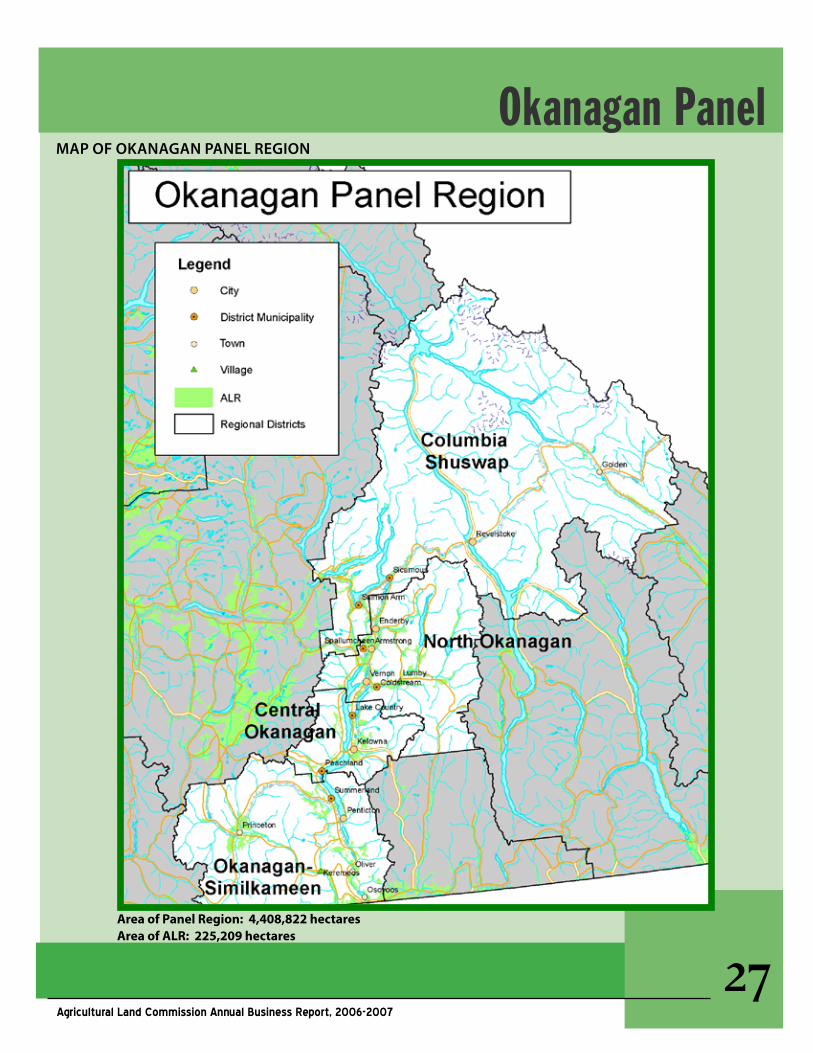
MaP OF OKanagan PanEl REgIOn
Okanagan Panel
AreaofPanelRegion:4,408,822hectaresAreaofALR:225,209hectares
��Agricultural Land Commission Annual Business Report, 2006-2007
PANELSTATISTICSApril1,2006-March31,2007
Number of Applications Received by Type
# OF aPPlICaTIOns ExClusIOns InClusIOns nOn-FaRM usE & suBdIvIsIOn
124 19 7 98
Area Included and Excluded and Agriculture Capability
REFusEd aPPROvEdagRICulTuRE CaPaBIlITy OF
aPPROvEd
Prime Mixed secondary
Inclusion area(hectares)
1 40 16 1 23
Exclusion area (hectares)
381 324 16 207 101
Plans and Bylaws Reviewed
CaTEgORy aREa nuMBER
Official Community Plans
Osoyoos, deep Creek, district of sicamous, Carrs landing, lower glenrosa, goats Peak, lakeview village
7
Regional growth strategiesRegional district of Okanagan similkameen
1
Park & Recreation Plans south Okanagan national Park 1
Other land use Plans Oliver 1
Conservation Covenantsspallumcheen, Okanagan Falls, yellow lake
2
TOTAL 12
Okanagan Panel
��Agricultural Land Commission Annual Business Report, 2006-2007
aPPlICaTIOns OF InTEREsT
The following selected examples illustrate how the Agricultural Land Commission panels responded to proposals to change the ALR boundary or to re-quests for subdivision or non-farm use of ALR lands. Applications are considered on the merits of each case at hand in the context of the Commission’s mandate and take into account an assessment of factors related to agricultural capability and suit-ability and impact upon the ALR.
Tower Ranch Ltd.#G-22342In 1988 the Commission of the day considered an application on land near Kelowna to exclude 181 ha for the purpose of developing a golf course and residential development. At that time the Com-mission agreed in principle to the use of the land as it held the view that community expansion at Kelowna should avoid lands suitable for tree fruit production. The subject lands were believed to be at an elevation which would not sustain commer-cial tree fruit production and it was noted that golf courses were an allowed use of ALR lands as per the ALR regulations of the day.
The Commission believed that in order for the de-velopment to occur for the intended purpose and in such a way as to limit impact on adjoining ALR lands, mitigation measures such as fencing, buffer-ing, cattle guards, restrictive covenants and farm land sensitive site and density planning and road design should be developed and implemented. As there was no time limit imposed by the Commis-sion, after several years the proponent activated the proposal and carried through with a develop-ment plan acceptable to the Commission.
In 2007, the proponent filed the subdivision plans and the Panel finalized the decision which exclud-ed 76 ha comprising the residential component of the Tower Ranch Golf Course development.
Subdivision for RelativesSeveral requests throughout the Okanagan ValleyIn 2006/07 the Panel considered a number of re-quests to subdivide ALR land in order to provide land for family members to build homes. In some cases two homes were in place or there were as many as four or more family members and argu-ments were made to sever the interests in the land to provide each family a separate title.
The Panel had concerns with many of the propos-als and did not grant approval noting that in most cases there would be a negative impact on the long-term agricultural potential of the land. In some cases the application was in keeping with the Commission’s Homesite Severance Policy (HSP) and those applications were approved. In many cases the land was acquired by the applicants well after the ALR had been designated and they did not meet the intent of the HSP.
The Panel recognizes the interest in maintaining family units and that population growth in the val-ley is lending to increases in residential land costs. However, the Panel is very cautious when it comes to responding to subdivision requests as there is a finite supply of suitable land for farming.
Township of SpallumcheenT-36892In December 2006, a non-farm use application was submitted by the Township of Spallumcheen on behalf of 12 landowners representing 15 unau-thorized non-farm uses in the ALR. The application arose from a home occupation “amnesty” program initiated by the Township. Over the years a num-ber of non-conforming home based businesses were developed. These businesses were for the most part inconsistent with the zoning bylaw and unknown to Township staff and Council. At pres-ent, the ALR Regulation permits the following in the ALR “a home occupation use, that is acces-sory to a dwelling, of not more than 100 m2 or
aPPlICaTIOns OF InTEREsT
Okanagan Panel
�0Agricultural Land Commission Annual Business Report, 2006-2007
such other area as specified in a local government bylaw: ” The purpose of the application was for the Panel to review home based businesses in the ALR that exceed the Township’s bylaw standards.
Commission and Township staff worked collab-oratively to review the bylaw, the purpose of which was to examine options on how to expand the home occupation footprint and bring many on the non-conforming uses into compliance with a new community standard. An amended bylaw increased the size of the home occupation footprint from the previous standard of 100 m2 to a maximum of 185 m2 and permits up to four non- resident employ-ees. Some businesses still exceeded this threshold and as part of the application a proposal was made to place covenants on those lands to require both the Panel’s approval and a zoning amendment if expansion was contemplated in the future.
After visiting the sites of the home-based business-es the Panel approved all the existing non-farm uses as requested. The Panel noted that gener-ally the businesses either occupied properties with marginal agricultural capability, or they had little impact on agricultural utility because of their small footprint, or they occupied abandoned farming structures. In agreeing to the application, the Panel emphasized that it did not support the expansion of any of the facilities without the submission of a non-farm use application.
This application was the second of two “batch” applications, the former of which was in 2005 and considered and approved eleven non-conforming home businesses.
PlannIng aCTIvITIEs / IssuEs OF InTEREsT
The following selected example illustrates how the integration and coordination of interests regarding land use planning and resource management require ongoing dialogue and col-laboration between local governments and the Agricultural Land Commission.
In 2006/07, the Panel worked collaboratively with the Town of Osoyoos, in assessing its community growth and long-term land use requirements through its official community plan review pro-cess. The Town has limited growth options due to biophysical constraints (mountains and lake), the U.S. border, ALR boundaries, and provincial Crown lands managed for environmental values. Recent growth rates experienced by the Town suggest that land use pressures may result in the Town soon having lesser access to new lands to accom-modate urban expansion. Through consultation and co-operation with the Panel the Town identi-fied new lands for development, and developed a policy framework that more efficiently used existing urban land. The Panel agreed to non-farm use designations in an ALR area which had limited suitability for agriculture due to existing subdivision patterns and biophysical constraints.
PlannIng aCTIvITIEs/IssuEs OF InTEREsT
Okanagan Panel
��Agricultural Land Commission Annual Business Report, 2006-2007
Message from the Vice-Chair
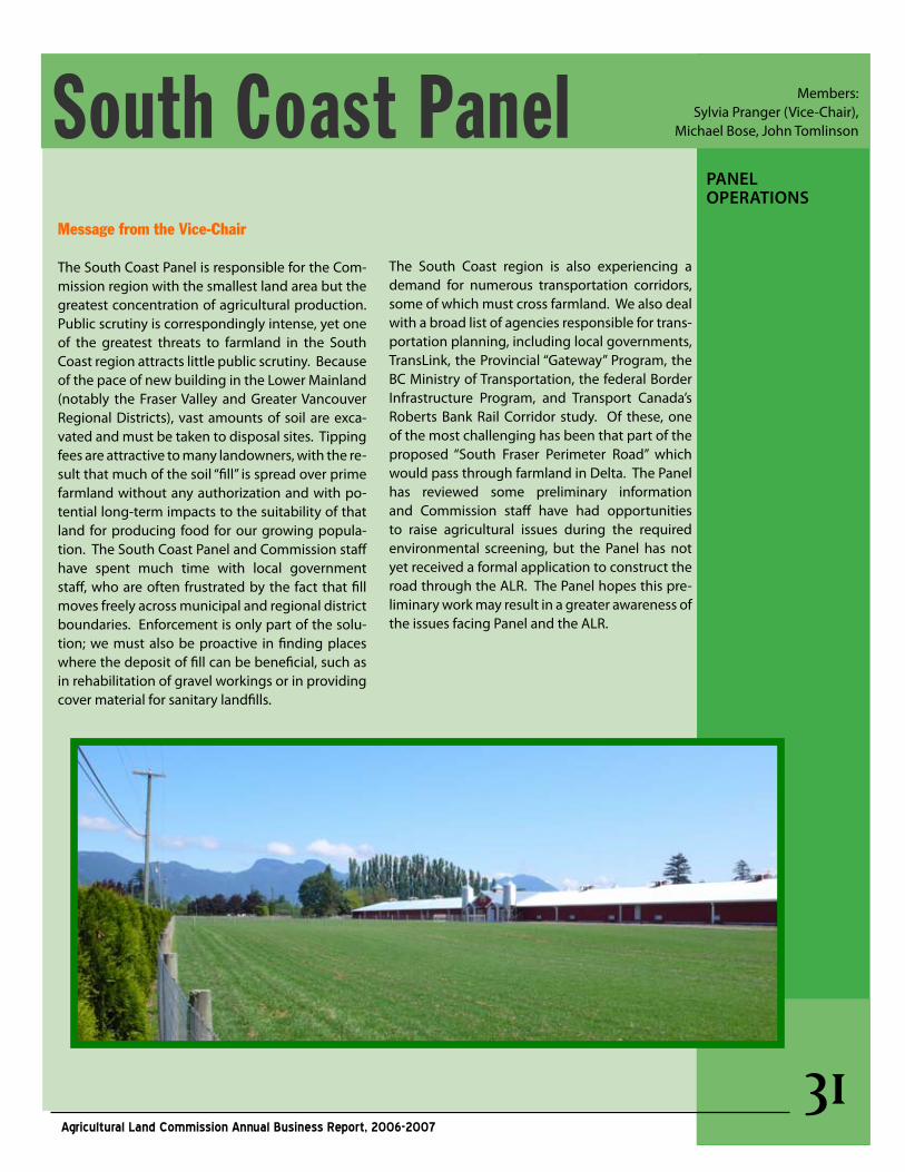
The South Coast Panel is responsible for the Com-mission region with the smallest land area but the greatest concentration of agricultural production. Public scrutiny is correspondingly intense, yet one of the greatest threats to farmland in the South Coast region attracts little public scrutiny. Because of the pace of new building in the Lower Mainland (notably the Fraser Valley and Greater Vancouver Regional Districts), vast amounts of soil are exca-vated and must be taken to disposal sites. Tipping fees are attractive to many landowners, with the re-sult that much of the soil “fill” is spread over prime farmland without any authorization and with po-tential long-term impacts to the suitability of that land for producing food for our growing popula-tion. The South Coast Panel and Commission staff have spent much time with local government staff, who are often frustrated by the fact that fill moves freely across municipal and regional district boundaries. Enforcement is only part of the solu-tion; we must also be proactive in finding places where the deposit of fill can be beneficial, such as in rehabilitation of gravel workings or in providing cover material for sanitary landfills.
The South Coast region is also experiencing a demand for numerous transportation corridors, some of which must cross farmland. We also deal with a broad list of agencies responsible for trans-portation planning, including local governments, TransLink, the Provincial “Gateway” Program, the BC Ministry of Transportation, the federal Border Infrastructure Program, and Transport Canada’s Roberts Bank Rail Corridor study. Of these, one of the most challenging has been that part of the proposed “South Fraser Perimeter Road” which would pass through farmland in Delta. The Panel has reviewed some preliminary information and Commission staff have had opportunities to raise agricultural issues during the required environmental screening, but the Panel has not yet received a formal application to construct the road through the ALR. The Panel hopes this pre-liminary work may result in a greater awareness of the issues facing Panel and the ALR.
South Coast PanelPanEl OPERaTIOns
Members: Sylvia Pranger (Vice-Chair),
Michael Bose, John Tomlinson
��Agricultural Land Commission Annual Business Report, 2006-2007
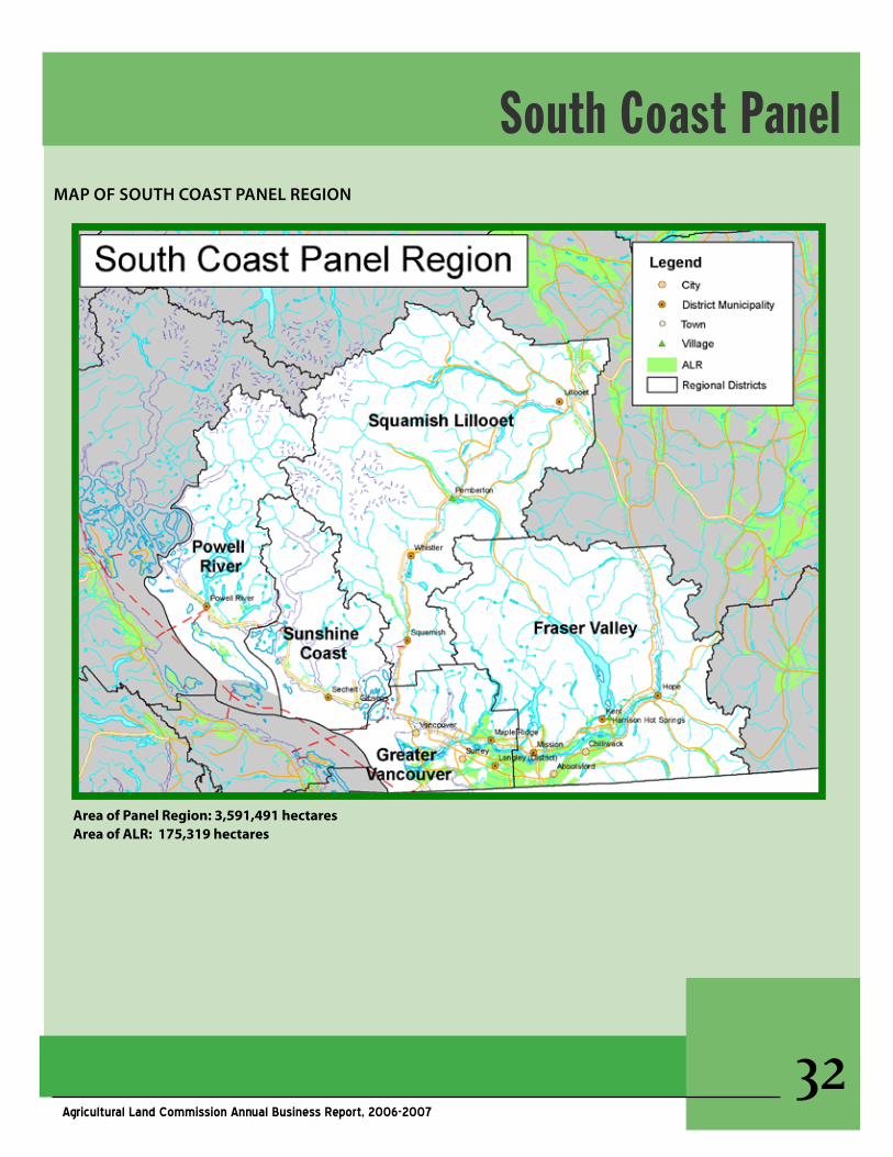
MaP OF sOuTh COasT PanEl REgIOn
AreaofPanelRegion:3,591,491hectaresAreaofALR:175,319hectares
South Coast Panel
��Agricultural Land Commission Annual Business Report, 2006-2007
PANELSTATISTICSApril1,2006-March31,2007
Number of Applications Received by Type
# OF aPPlICaTIOns ExClusIOns InClusIOns nOn-FaRM usE & suBdIvIsIOn
118 12 2 104
Panel Decisions
REFusEd aPPROvEdagRICulTuRE CaPaBIlITy OF
aPPROvEd
Prime Mixed secondary
Inclusion area(hectares)
8 1 1 0 0
Exclusion area (hectares)
630 16 5 5 6
Plans and Bylaws Reviewed
CaTEgORy aREa nuMBER
Official Community PlansFraser valley Regional district, greater vancouver Regional district, squamish-lilloet Regional district, sunshine Coast Regional district
6
Regional growth strategies squamish-lillooet Regional district 1
Implementing BylawsZoning, subdivision & other bylaws
Fraser valley Regional dsitrictsunshine Coast Regional district
11
Transportation Plans greater vancouver Regional district 3
Parks & Recreation Plans squamish-lillooet Regional district 1
Conservation Covenants 0
TOTAL 13
South Coast Panel
��Agricultural Land Commission Annual Business Report, 2006-2007
aPPlICaTIOns OF InTEREsT
The following selected examples illustrate how the Agricultural Land Commission panels responded to proposals to change the ALR boundary or to re-quests for subdivision or non-farm use of ALR lands. Applications are considered on the merits of each case at hand in the context of the Commission’s mandate and take into account an assessment of factors related to agricultural capability and suit-ability and impact upon the ALR.
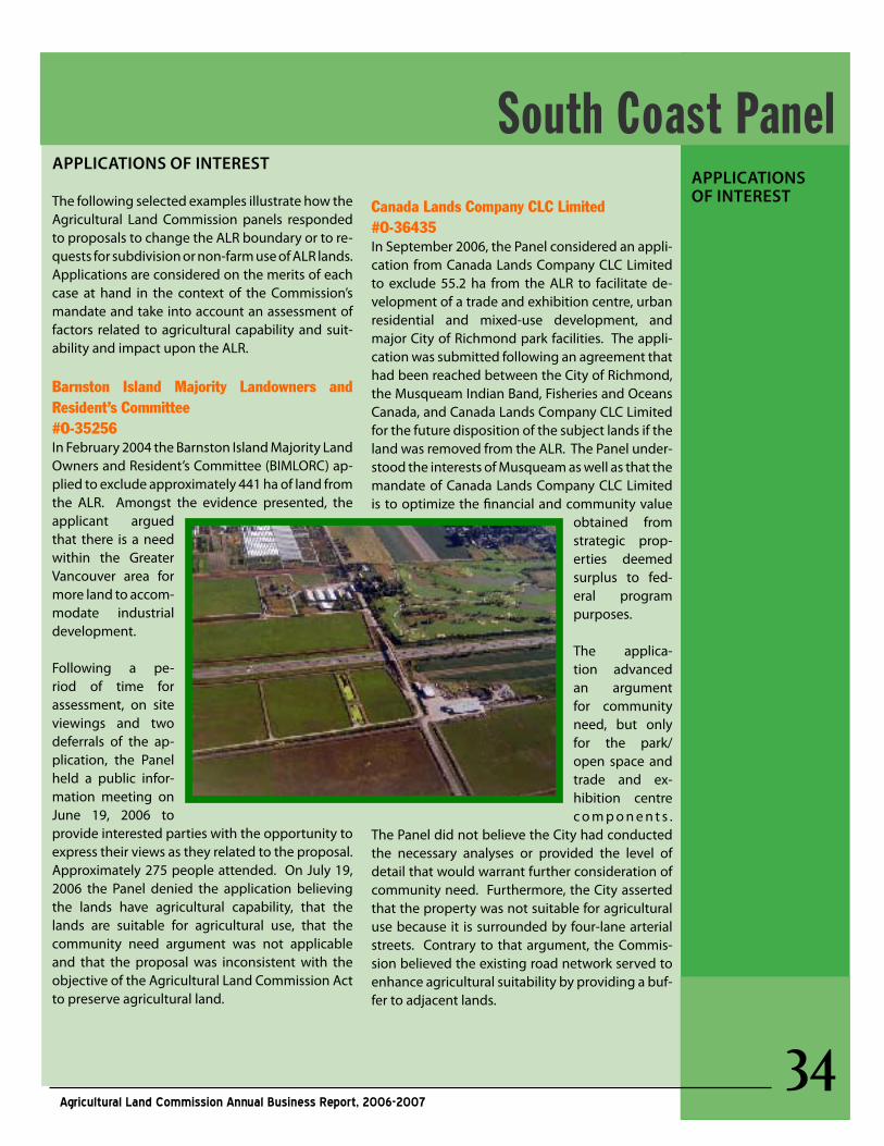
Barnston Island Majority Landowners and Resident’s Committee#O-35256In February 2004 the Barnston Island Majority Land Owners and Resident’s Committee (BIMLORC) ap-plied to exclude approximately 441 ha of land from the ALR. Amongst the evidence presented, the applicant argued that there is a need within the Greater Vancouver area for more land to accom-modate industrial development.
Following a pe-riod of time for assessment, on site viewings and two deferrals of the ap-plication, the Panel held a public infor-mation meeting on June 19, 2006 to provide interested parties with the opportunity to express their views as they related to the proposal. Approximately 275 people attended. On July 19, 2006 the Panel denied the application believing the lands have agricultural capability, that the lands are suitable for agricultural use, that the community need argument was not applicable and that the proposal was inconsistent with the objective of the Agricultural Land Commission Act to preserve agricultural land.
Canada Lands Company CLC Limited#O-36435In September 2006, the Panel considered an appli-cation from Canada Lands Company CLC Limited to exclude 55.2 ha from the ALR to facilitate de-velopment of a trade and exhibition centre, urban residential and mixed-use development, and major City of Richmond park facilities. The appli-cation was submitted following an agreement that had been reached between the City of Richmond, the Musqueam Indian Band, Fisheries and Oceans Canada, and Canada Lands Company CLC Limited for the future disposition of the subject lands if the land was removed from the ALR. The Panel under-stood the interests of Musqueam as well as that the mandate of Canada Lands Company CLC Limited is to optimize the financial and community value
obtained from strategic prop-erties deemed surplus to fed-eral program purposes.
The applica-tion advanced an argument for community need, but only for the park/open space and trade and ex-hibition centre c o m p o n e n t s .
The Panel did not believe the City had conducted the necessary analyses or provided the level of detail that would warrant further consideration of community need. Furthermore, the City asserted that the property was not suitable for agricultural use because it is surrounded by four-lane arterial streets. Contrary to that argument, the Commis-sion believed the existing road network served to enhance agricultural suitability by providing a buf-fer to adjacent lands.
aPPlICaTIOns OF InTEREsT
South Coast Panel
��Agricultural Land Commission Annual Business Report, 2006-2007
The Panel found that the land was suitable for ag-ricultural use and that it would be inappropriate to consider excluding land with prime agricultural capability from the ALR.
Applications to Place Fill on ALR LandsDuring 2006/07 the Panel considered a number of applications for placement of fill as a non-farm use of ALR land. While proposals for placement of fill do occur beyond this Panel region, the pressure to place fill on ALR land in the Lower Fraser Valley is sig-nificant due to the vibrant construction sector of the economy in and around BC’s largest urban based re-gion. The total volume of fill proposed to be placed on ALR land in 17 applications was approximately 390,000 m3. To put this into perspective, this would equate to approximately 65, 000 dump truck loads.
In reviewing fill applications, the Panel has become increasingly concerned about the potential nega-tive impact on the long-term agricultural potential of land. The placement of fill can also have profound impacts on neighbouring lands. For example, fill placed on one property may alter natural drainage patterns resulting in increased water accumulations on adjacent lands. The Panel now seeks to ensure that it has sufficient technical information in order to properly assess an application.
Of the 17 applications considered in 2006/07, the Panel made decisions on 7 proposals of which only 3 were given approval. Ten other applications were
PlannIng aCTIvITIEs/ IssuEs OF InTEREsT
deferred pending the receipt of additional tech-nical reports and details.
PlannIng aCTIvITIEs / IssuEs OF InTEREsTThe following selected example illustrates how the integration and coordination of interests regarding land use planning and resource management require ongoing dialogue and collaboration between local governments and the Agricultural Land Commission.
In November 2006, the District of Maple Ridge Council adopted an Official Community Plan (OCP), following a thorough review of its needs, including a model review of the role of agri-culture in the community. The OCP identifies the need for a commercial and industrial lands strategy, but the OCP specifically defers that study in order that the first item in the compre-hensive strategy will be the development of an Agriculture Plan.
Council has established Maple Ridge’s first Agricultural Advisory Committee and the Com-mission along with the Ministry of Agriculture and Lands will be represented and will assist Maple Ridge with its agricultural planning. From early on, the Commission worked col-laboratively with Maple Ridge from the point of view of supporting the development of an OCP that considered agricultural interests and the ALR.
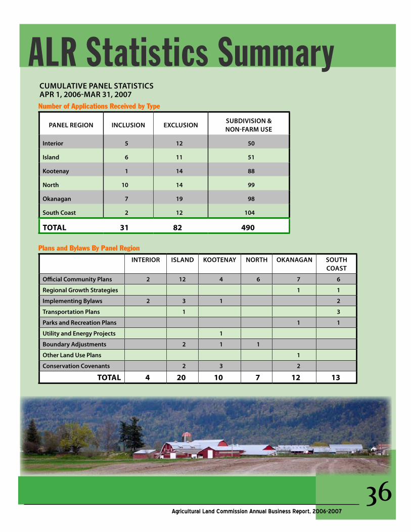
Number of Applications Received by Type
PanEl REgIOn InClusIOn ExClusIOnsuBdIvIsIOn & nOn-FaRM usE
Interior 5 12 50
Island 6 11 51
Kootenay 1 14 88
north 10 14 99
Okanagan 7 19 98
south Coast 2 12 104
TOTAL 31 82 490
Plans and Bylaws By Panel Region
InTERIOR Island KOOTEnay nORTh OKanagan sOuTh COasT
Official Community Plans 2 12 4 6 7 6
Regional growth strategies 1 1
Implementing Bylaws 2 3 1 2
Transportation Plans 1 3
Parks and Recreation Plans 1 1
utility and Energy Projects 1
Boundary adjustments 2 1 1
Other land use Plans 1
Conservation Covenants 2 3 2
TOTAL 4 20 10 7 12 13
ALR Statistics SummaryCuMulaTIvE PanEl sTaTIsTICs aPR 1, 2006-MaR 31, 2007
��Agricultural Land Commission Annual Business Report, 2006-2007
��Agricultural Land Commission Annual Business Report, 2006-2007
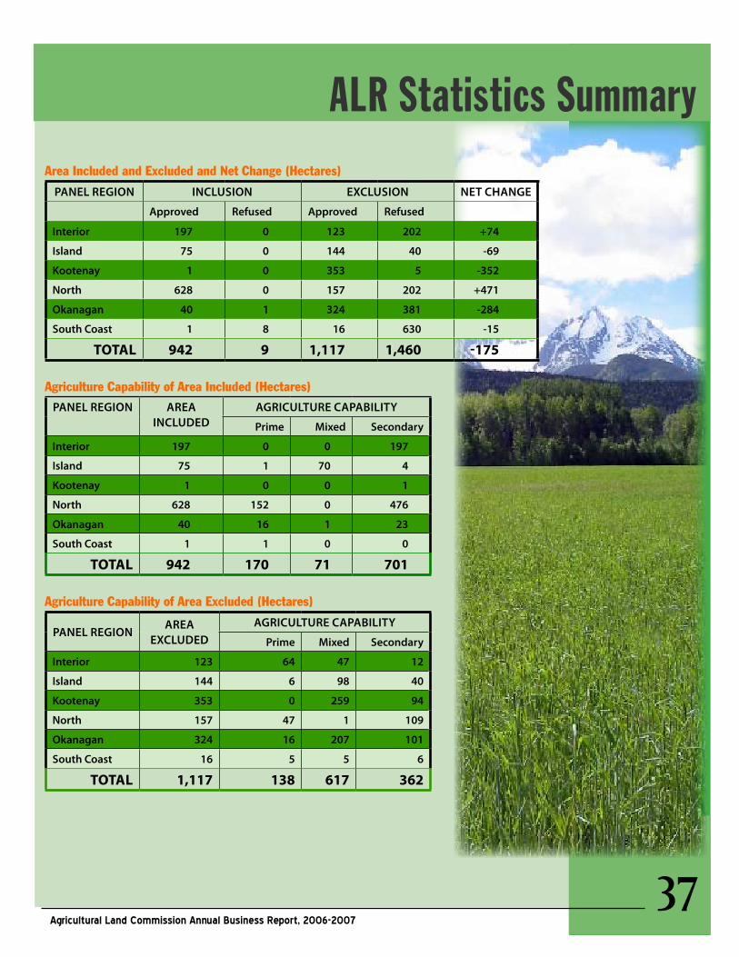
Area Included and Excluded and Net Change (Hectares)
PanEl REgIOn InClusIOn ExClusIOn nET ChangE
approved Refused approved Refused
Interior 197 0 123 202 +74
Island 75 0 144 40 -69
Kootenay 1 0 353 5 -352
north 628 0 157 202 +471
Okanagan 40 1 324 381 -284
south Coast 1 8 16 630 -15
TOTAL 942 9 1,117 1,460 -175
Agriculture Capability of Area Included (Hectares)PanEl REgIOn aREa
InCludEdagRICulTuRE CaPaBIlITy
Prime Mixed secondary
Interior 197 0 0 197
Island 75 1 70 4
Kootenay 1 0 0 1
north 628 152 0 476
Okanagan 40 16 1 23
south Coast 1 1 0 0
TOTAL 942 170 71 701
Agriculture Capability of Area Excluded (Hectares)
PanEl REgIOnaREa
ExCludEdagRICulTuRE CaPaBIlITy
Prime Mixed secondary
Interior 123 64 47 12
Island 144 6 98 40
Kootenay 353 0 259 94
north 157 47 1 109
Okanagan 324 16 207 101
south Coast 16 5 5 6
TOTAL 1,117 138 617 362
ALR Statistics Summary
��Agricultural Land Commission Annual Business Report, 2006-2007
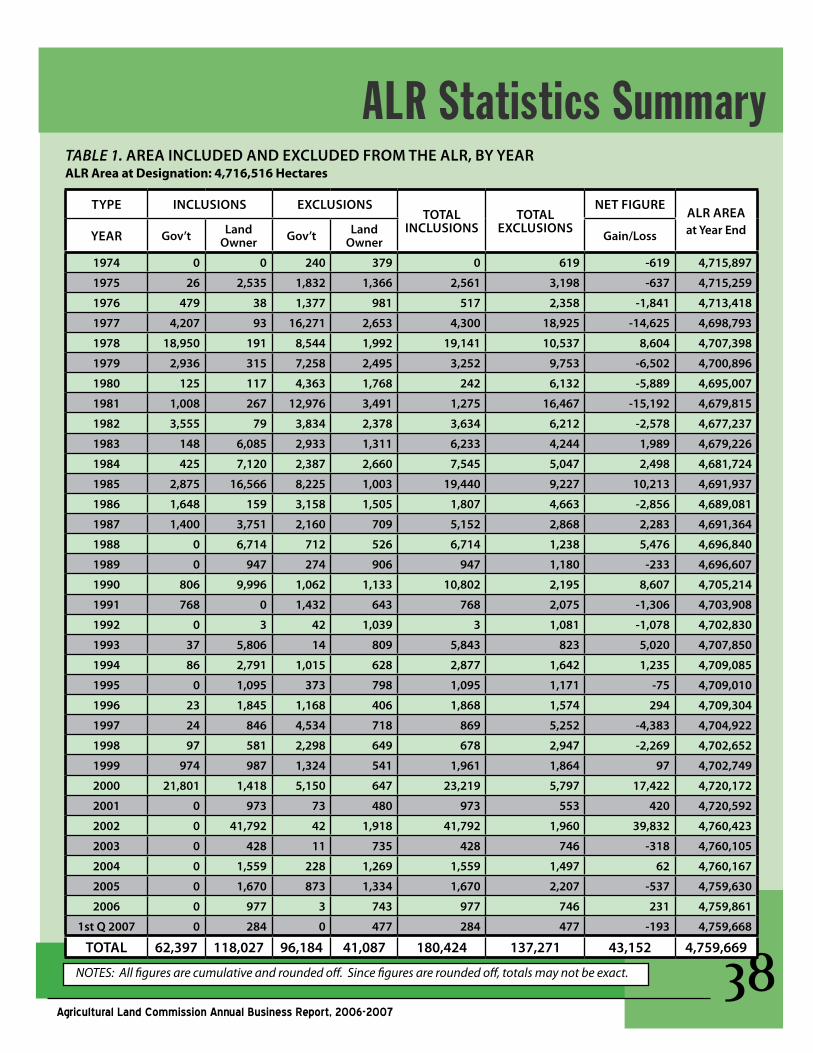
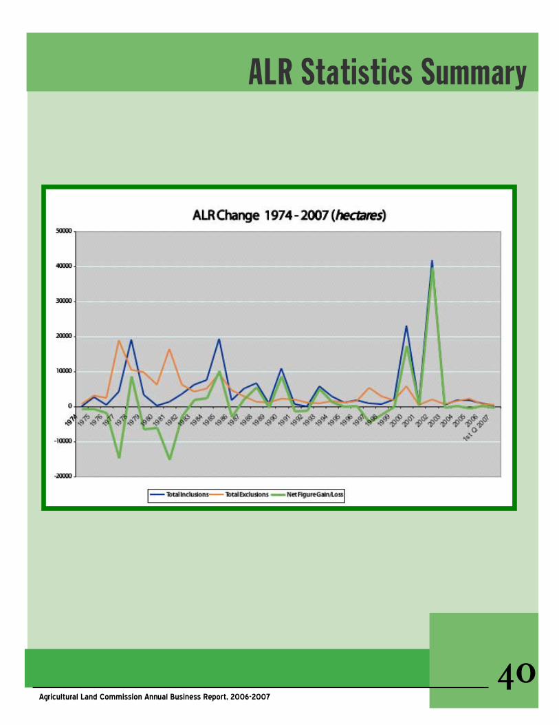
ALR Statistics SummaryTABLE1. aREa InCludEd and ExCludEd FROM ThE alR, By yEaRALRAreaatDesignation:4,716,516Hectares
TyPE InClusIOns ExClusIOnsTOTal
InClusIOnsTOTal
ExClusIOns
nET FIguREalR aREa at year EndyEaR gov’t land
Owner gov’t land Owner gain/loss
1974 0 0 240 379 0 619 -619 4,715,897
1975 26 2,535 1,832 1,366 2,561 3,198 -637 4,715,259
1976 479 38 1,377 981 517 2,358 -1,841 4,713,418
1977 4,207 93 16,271 2,653 4,300 18,925 -14,625 4,698,793
1978 18,950 191 8,544 1,992 19,141 10,537 8,604 4,707,398
1979 2,936 315 7,258 2,495 3,252 9,753 -6,502 4,700,896
1980 125 117 4,363 1,768 242 6,132 -5,889 4,695,007
1981 1,008 267 12,976 3,491 1,275 16,467 -15,192 4,679,815
1982 3,555 79 3,834 2,378 3,634 6,212 -2,578 4,677,237
1983 148 6,085 2,933 1,311 6,233 4,244 1,989 4,679,226
1984 425 7,120 2,387 2,660 7,545 5,047 2,498 4,681,724
1985 2,875 16,566 8,225 1,003 19,440 9,227 10,213 4,691,937
1986 1,648 159 3,158 1,505 1,807 4,663 -2,856 4,689,081
1987 1,400 3,751 2,160 709 5,152 2,868 2,283 4,691,364
1988 0 6,714 712 526 6,714 1,238 5,476 4,696,840
1989 0 947 274 906 947 1,180 -233 4,696,607
1990 806 9,996 1,062 1,133 10,802 2,195 8,607 4,705,214
1991 768 0 1,432 643 768 2,075 -1,306 4,703,908
1992 0 3 42 1,039 3 1,081 -1,078 4,702,830
1993 37 5,806 14 809 5,843 823 5,020 4,707,850
1994 86 2,791 1,015 628 2,877 1,642 1,235 4,709,085
1995 0 1,095 373 798 1,095 1,171 -75 4,709,010
1996 23 1,845 1,168 406 1,868 1,574 294 4,709,304
1997 24 846 4,534 718 869 5,252 -4,383 4,704,922
1998 97 581 2,298 649 678 2,947 -2,269 4,702,652
1999 974 987 1,324 541 1,961 1,864 97 4,702,749
2000 21,801 1,418 5,150 647 23,219 5,797 17,422 4,720,172
2001 0 973 73 480 973 553 420 4,720,592
2002 0 41,792 42 1,918 41,792 1,960 39,832 4,760,423
2003 0 428 11 735 428 746 -318 4,760,105
2004 0 1,559 228 1,269 1,559 1,497 62 4,760,167
2005 0 1,670 873 1,334 1,670 2,207 -537 4,759,630
2006 0 977 3 743 977 746 231 4,759,861
1st Q 2007 0 284 0 477 284 477 -193 4,759,668
TOTal 62,397 118,027 96,184 41,087 180,424 137,271 43,152 4,759,669
NOTES: All figures are cumulative and rounded off. Since figures are rounded off, totals may not be exact.
��Agricultural Land Commission Annual Business Report, 2006-2007
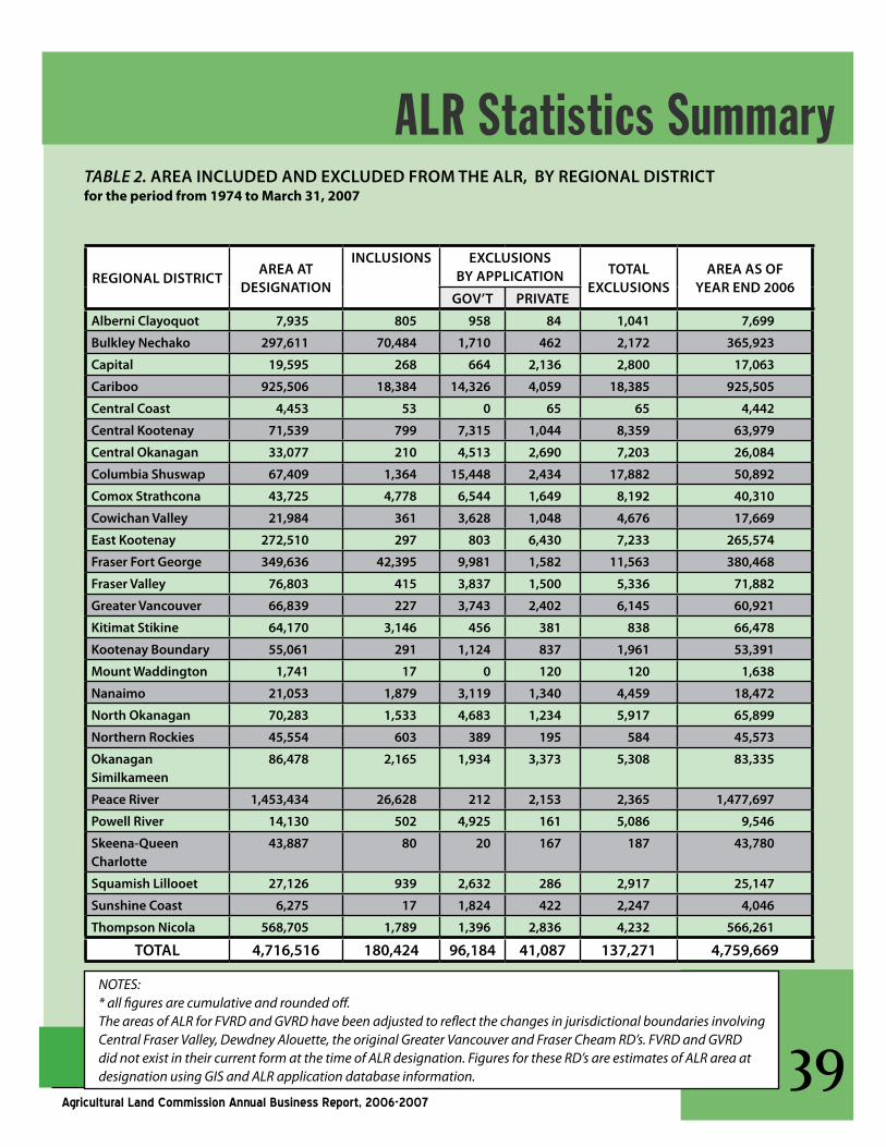
ALR Statistics SummaryTABLE2. aREa InCludEd and ExCludEd FROM ThE alR, By REgIOnal dIsTRICTfortheperiodfrom1974toMarch31,2007
REgIOnal dIsTRICTaREa aT
dEsIgnaTIOn
InClusIOns ExClusIOns By aPPlICaTIOn TOTal
ExClusIOnsaREa as OF
yEaR End 2006gOv’T PRIvaTE
alberni Clayoquot 7,935 805 958 84 1,041 7,699
Bulkley nechako 297,611 70,484 1,710 462 2,172 365,923
Capital 19,595 268 664 2,136 2,800 17,063
Cariboo 925,506 18,384 14,326 4,059 18,385 925,505
Central Coast 4,453 53 0 65 65 4,442
Central Kootenay 71,539 799 7,315 1,044 8,359 63,979
Central Okanagan 33,077 210 4,513 2,690 7,203 26,084
Columbia shuswap 67,409 1,364 15,448 2,434 17,882 50,892
Comox strathcona 43,725 4,778 6,544 1,649 8,192 40,310
Cowichan valley 21,984 361 3,628 1,048 4,676 17,669
East Kootenay 272,510 297 803 6,430 7,233 265,574
Fraser Fort george 349,636 42,395 9,981 1,582 11,563 380,468
Fraser valley 76,803 415 3,837 1,500 5,336 71,882
greater vancouver 66,839 227 3,743 2,402 6,145 60,921
Kitimat stikine 64,170 3,146 456 381 838 66,478
Kootenay Boundary 55,061 291 1,124 837 1,961 53,391
Mount Waddington 1,741 17 0 120 120 1,638
nanaimo 21,053 1,879 3,119 1,340 4,459 18,472
north Okanagan 70,283 1,533 4,683 1,234 5,917 65,899
northern Rockies 45,554 603 389 195 584 45,573
Okanagan similkameen
86,478 2,165 1,934 3,373 5,308 83,335
Peace River 1,453,434 26,628 212 2,153 2,365 1,477,697
Powell River 14,130 502 4,925 161 5,086 9,546
skeena-Queen Charlotte
43,887 80 20 167 187 43,780
squamish lillooet 27,126 939 2,632 286 2,917 25,147
sunshine Coast 6,275 17 1,824 422 2,247 4,046
Thompson nicola 568,705 1,789 1,396 2,836 4,232 566,261
TOTal 4,716,516 180,424 96,184 41,087 137,271 4,759,669
NOTES:* all figures are cumulative and rounded off.The areas of ALR for FVRD and GVRD have been adjusted to reflect the changes in jurisdictional boundaries involving Central Fraser Valley, Dewdney Alouette, the original Greater Vancouver and Fraser Cheam RD’s. FVRD and GVRD did not exist in their current form at the time of ALR designation. Figures for these RD’s are estimates of ALR area at designation using GIS and ALR application database information.
�0Agricultural Land Commission Annual Business Report, 2006-2007
ALR Statistics Summary
��Agricultural Land Commission Annual Business Report, 2006-2007
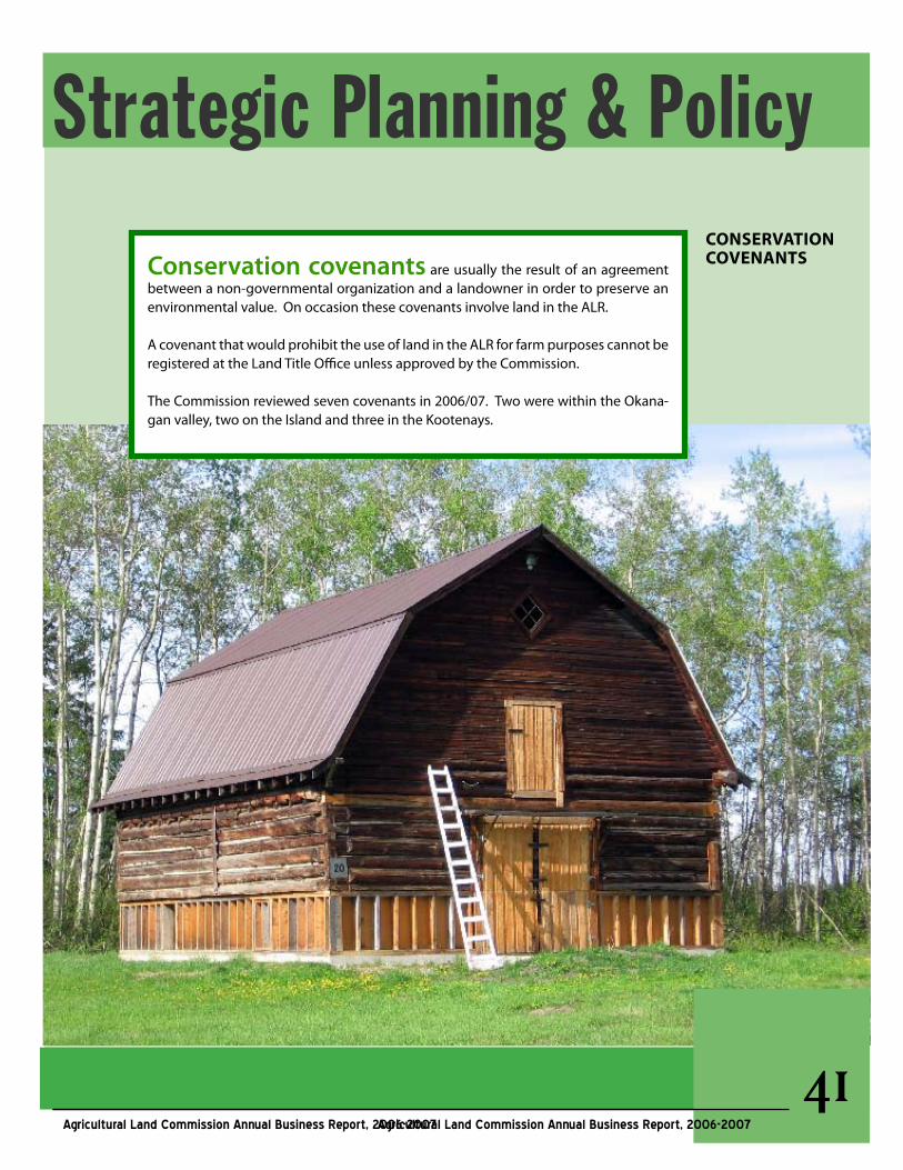
Strategic Planning & PolicyCONSERvATIONCOvENANTSConservation covenants are usually the result of an agreement
between a non-governmental organization and a landowner in order to preserve an environmental value. On occasion these covenants involve land in the ALR.
A covenant that would prohibit the use of land in the ALR for farm purposes cannot be registered at the Land Title Office unless approved by the Commission.
The Commission reviewed seven covenants in 2006/07. Two were within the Okana-gan valley, two on the Island and three in the Kootenays.
Agricultural Land Commission Annual Business Report, 2006-2007
��
��Agricultural Land Commission Annual Business Report, 2006-2007
delegation is the authorization by the Commission to a local government or other authority to act on its behalf to make use and subdivision decisions in the ALR under section 26 of the Agricultural Land Commission Act.
DelegationAgreementsInPlace:1. Fraser Fort George Regional District§ Covers seven Electoral Areas which
have Official Community Plans (OCP) that were reviewed and approved by the Commission. The original agree-ment has been in place since January 2001 and subsequently amended as new OCPs are approved by the North Panel.
§ During the year the North Panel reviewed decisions made by the Regional District in terms of the delegation agreement. Between January 2001 and March 31, 2007, the Regional District made 34 deci-sions for subdivision or non-farm use involving land in the ALR. In the 2006/07 the Regional District made 10 decisions under the delegated decision-making authority.
§ While the North Panel generally concurred with the majority of the decisions made by the Regional Dis-trict, it identified a small number of issues that it wished to discuss with the Regional District. These issues included subdivision in the areas sur-rounding Prince George referred to in the OCPs as the Prince George Fringe area and decisions made in terms of Section 946 of the Local Government
Act.
2. Regional District of East Kootenay§ Wasa-Ta Ta Creek-Skookumchuk-
Sheep Creek area Land Use Bylaw. Agreement in place since 2003 and renewed on November 1, 2006 for an indefinite term.
§ Since the agreement came into ef-fect, three decisions have been made by the Regional District for subdivi-sion or non-farm use, all of which have been made within the 2006/07 fiscal year.
3. Oil and Gas Commission§ The delegation agreement with the
Oil and Gas Commission (OGC) has been in place since April 2004. The agreement delegates decision-mak-ing ability regarding specified oil and gas related proposals within the Peace River and Northern Rockies Re-gional Districts.
§ In 2006/07 a total of 839 oil and gas activities on ALR lands were exempt-ed from making an application based on reporting and reclamation condi-tions. The OGC received 39 Schedule “B” post reclamation reports where ALR lands were no longer needed for oil and gas use. The OGC Deputy Commissioner approved six applica-tions and referred four applications to the North Panel for decision. Seven-teen complaints were received by the OGC regarding oil and gas activities on ALR land and two investigations took place.
DELEGATIONOfDECISION-MAKINGToLocalGovernmentsandOtherAuthorities
Strategic Planning and Policy
��
��Agricultural Land Commission Annual Business Report, 2006-2007
EMERGINGISSUESEstablishingLargerPanels
EsTaBlIshIng laRgER PanEls during the past year the Commission has explored the concept of establishing Inter-Regional Panels in certain instances. The establishment of such a Panel would be application or issue specific and may involve:
§An application or issue that straddles Panel boundaries §An application or issue of a substantive nature either in terms
of size or having the potential to impact decision-making in two or more Panel regions
§A substantive planning review§An application or issue that is potentially precedent setting§An application or issue of provincial significance §A situation where a Panel may benefit from the input of other
Commissioners having experience or expertise as it relates to an application or issue
The process for establishing a larger Panel is still in the developmental stages and will only be considered where there are unique and specific circumstances. Conceptually, the process for establishing a larger Panel would involve the preparation of a staff report as it relates to the proposal, review of the report by the ALC Chair and the Vice-Chair of the Panel, fol-lowed by a decision of the Chair on whether to establish a larger Panel consisting of the Panel in which the application or issue arose and addi-tional Commissioners as deemed necessary.
Strategic Planning and Policy
��Agricultural Land Commission Annual Business Report, 2006-2007
suBdIvIsIOn aPPlICaTIOns
Over the course of the year the consideration of subdivision applications formed a large part of the workload in each Panel Region. Sub-division proposals are based on a wide variety of reasons such as family estate settlements, real estate development, providing family members with proper-ties, inter-generational farm transfers and financing to name a few.
When it comes to considering individual applications, Commissioners are faced with making decisions based on the evidence before them as provided by the applicant(s), local government, staff and their own observations following site inspections.
An example of a potentially positive sub-division from an agricultural perspective may involve the creation of a small lot for a family member on non-productive ground to ensure the family member continues to have an active role in farm-ing the parent parcel or if the subdivision facilitates the inter-generational transfer of a farm. However, these considerations are a small part of the comprehensive review. The Commissioners must also take into consideration many other fac-
tors such as existing parcel size, prior subdivision and non-farm use approvals, agricultural quality and suitability of the land, potential impact on adjacent and nearby farm operations, regional influ-ences, etc.
Where a subdivision is proposed to cre-ate a non-farm, rural residential parcel(s), even if the parcel is intended for a family member, it often carries unacceptable consequences to agriculture. A sub-division may lead to developments that would not only remove land from production, but would also introduce an element of risk for farm operators by potentially compromising the continued use of established farm management practices. For example, the use of bird cannons by berry farmers is a an ongoing source of irritation to nearby residential areas and calls are routinely made to local governments seeking the discontinua-tion of this farm management practice.
As members of an administrative tribu-nal, the Commissioners must consider each application on its own merits and in the context of the objectives of the Ag-ricultural Land Commission Act – namely is the subdivision in aid of agriculture or will agricultural potential be diminished.
EMERGINGISSUES:SubdivisionApplications
Strategic Planning and Policy
��
��Agricultural Land Commission Annual Business Report, 2006-2007
alR MaPs
The Commission maintains the official maps of the ALR which are indexed by Regional Dis-trict.
At present, two different methods are used to produce ALR maps, depending on the Regional District. Under the Commission’s original map-ping system, base maps show the location of the ALR boundaries at a map scale of 1:50,000 or larger. Constituent maps (where available) show the ALR boundaries in greater detail, gen-erally at a scale of 1:10,000. For nine Regional Districts, this mapping system is still maintained manually.
For the rest of the Regional Districts, digital GIS (Geographic Information Systems) data is used to produce the official ALR maps. Maps are at 1:20,000 scale. They are referenced to provincial standard TRIM digital data.
The Commission is currently converting to digital ALR maps for all Regional Districts. Refer to the Commission’s web site (www.alc.gov.bc.ca/mapping/status) for the current sta-tus of ALR mapping by Regional District.
Refer to the Commission’s web site (www.alc.gov.bc.ca/mapping/obtaining_maps.htm) for details on how to order maps. Digital ALR maps can also be viewed online.
Mapping / GISREgIOnal dIsTRICTs MaInTaInEd In TRIM-BasEd, 1:20,000 MaPs
Alberni-Clayoquot TRIM-based alR maps: 5
fraser-fortGeorge TRIM-based alR maps: 94
Bulkley-Nechako TRIM-based alR maps: 114
MountWaddington TRIM-based alR maps: 6
Capital TRIM-based alR maps: 21
Nanaimo TRIM-based alR maps: 11
Cariboo TRIM-based alR maps: 249
NorthernRockies TRIM-based alR maps: 24
CentralCoast TRIM-based alR maps: 7
PeaceRiver TRIM-based alR maps: 220
CentralKootenay TRIM-based alR maps: 63
PowellRiver TRIM-based alR maps: 14
Comox-Strathcona TRIM-based alR maps: 25
Skeena-QueenCharlotte TRIM-based alR maps: 30
Cowichanvalley TRIM-based alR maps: 13
Squamish-Lillooet TRIM-based alR maps: 30
Kitimat-Stikine TRIM-based alR maps: 62
Thompson-Nicola TRIM-based alR maps: 180
REGIONALDISTRICTSMAINTAINEDIN1:50,000BASEMAPSANDCONSTITUENTMAPS:
Central Okanagan alR Base maps: 5 Constituent maps: 33
Kootenay-Boundary alR Base maps: 9 Constituent maps: 25
Columbia shuswap alR Base maps: 22 Constituent maps: 39
north Okanagan alR Base maps: 11 Constituent maps: 41
East Kootenay alR Base maps: 17 Constituent maps: 15
Okanagan-similkameen alR Base maps: 18 Constituent maps: 44
Fraser valley alR Base maps: 10 Constituent maps: 43
sunshine Coast alR Base maps: 3 Constituent maps: 1
greater vancouver alR Base maps: 5 Constituent maps: 47
��
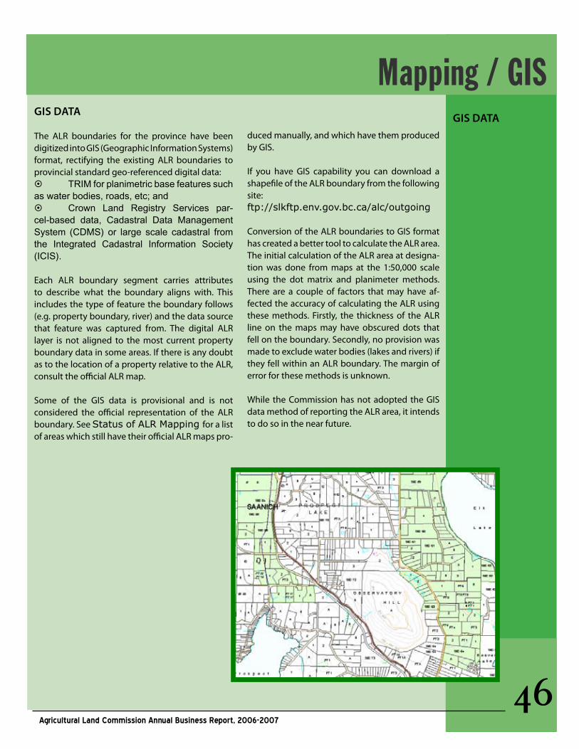
��Agricultural Land Commission Annual Business Report, 2006-2007
gIs daTa
The ALR boundaries for the province have been digitized into GIS (Geographic Information Systems) format, rectifying the existing ALR boundaries to provincial standard geo-referenced digital data:§ TRIM for planimetric base features such as water bodies, roads, etc; and § Crown Land Registry Services par-cel-based data, Cadastral Data Management System (CDMS) or large scale cadastral from the Integrated Cadastral Information Society (ICIS).
Each ALR boundary segment carries attributes to describe what the boundary aligns with. This includes the type of feature the boundary follows (e.g. property boundary, river) and the data source that feature was captured from. The digital ALR layer is not aligned to the most current property boundary data in some areas. If there is any doubt as to the location of a property relative to the ALR, consult the official ALR map.
Some of the GIS data is provisional and is not considered the official representation of the ALR boundary. See Status of ALR Mapping for a list of areas which still have their official ALR maps pro-
duced manually, and which have them produced by GIS.
If you have GIS capability you can download a shapefile of the ALR boundary from the following site: ftp://slkftp.env.gov.bc.ca/alc/outgoing
Conversion of the ALR boundaries to GIS format has created a better tool to calculate the ALR area. The initial calculation of the ALR area at designa-tion was done from maps at the 1:50,000 scale using the dot matrix and planimeter methods. There are a couple of factors that may have af-fected the accuracy of calculating the ALR using these methods. Firstly, the thickness of the ALR line on the maps may have obscured dots that fell on the boundary. Secondly, no provision was made to exclude water bodies (lakes and rivers) if they fell within an ALR boundary. The margin of error for these methods is unknown.
While the Commission has not adopted the GIS data method of reporting the ALR area, it intends to do so in the near future.
Mapping / GISgIs daTa
2006/07 Financial Report
dEsCRIPTIOn2006/07 2006/07
BudgET aCTual
SALARIES $1,165,000 $1,075,600
BENEFITS $301,000 $264,800
COMMISSION $240,000 $301,500
STAFF TRAVEL $70,000 $68,300
BUILDING OCCUPANCY $170,000 $165,200
PROF SERVICES CONTRACTS $30,000 $8,800
LEGAL CONTRACTS $25,000 $22,000
INFO SYSTEMS $40,000 $55,300
OFFICE SUPPLIES & BUSINESS EXPENSES
$40,000 $44,500
STAT ADVERTISING $15,000 $6,200
UTILITIES & MATERIALS $1,000 $200
VEHICLES $10,000 $10,700
AMMORTIZATION $1,000 $1,100
OTHER EXPENSES 0 $1000
FTEs 22 19.67
TOTALBUDGET $2,108,000 $2,025,200
����Agricultural Land Commission Annual Business Report, 2006-2007


![Thurston County Agricultural Land Pocket Gopher Evaluation · [THURSTON COUNTY AGRICULTURAL LAND POCKET GOPHER EVALUATION] March 30, 2014 3 Thurston County Agricultural Land Pocket](https://img.pdfslide.us/doc/110x75/5b00b2377f8b9a256b90627a/thurston-county-agricultural-land-pocket-gopher-evaluation-thurston-county-agricultural.jpg)


![[Challenge:Future] Agricultural land deficiency](https://img.pdfslide.us/doc/110x75/54c4b3984a795915788b456c/challengefuture-agricultural-land-deficiency.jpg)