Embed Size (px)
Citation preview
Annotated Outline Draft Environmental Impact Statement
Durham-Orange Light Rail Transit Project
December 2013
DIN 01033

Annotated Outl ine
Durham-Orange Light Rail Transit Project | December 2013 |i DRAFT
Table of Contents
Executive Summary ................................................................................................................................... E-1
1. Purpose and Need................................................................................................................................ 1
1.1 Problem Statement ..................................................................................................................................... 1
1.2 Corridor Description .................................................................................................................................... 1
1.3 Needs of the D-O Corridor .......................................................................................................................... 1
1.4 Goals and Objectives .................................................................................................................................. 1
2. Alternatives Considered ....................................................................................................................... 3
2.1 No-Build Alternative ................................................................................................................................... 3
2.2 Build Alternative ......................................................................................................................................... 3
2.3 TSM ............................................................................................................................................................. 4
3. Transportation ...................................................................................................................................... 7
3.1 Regional Travel Patterns ............................................................................................................................. 7
3.2 Public Transportation ................................................................................................................................. 7
3.3 Roadways ................................................................................................................................................... 7
3.4 Parking ........................................................................................................................................................ 7
3.5 Freight and Passenger Rail ......................................................................................................................... 7
3.6 Airports ....................................................................................................................................................... 7
3.7 Bicycle and Pedestrian Facilities ................................................................................................................. 7
4. Affected Environment and Environmental Consequences ................................................................... 8
4.1 Land Use, Public Policy, and Zoning ............................................................................................................ 8
4.2 Socio-Economic and Demographic Conditions ........................................................................................... 8
4.3 Neighborhoods, Community Services, and Community Facilities ............................................................... 8
4.4 Visual and Aesthetic Considerations ........................................................................................................... 9
4.5 Cultural, Historic, and Archaeological Resources ....................................................................................... 9
4.6 Public Parkland and Recreational Areas ..................................................................................................... 9
4.7 Natural Resources and Ecosystems ............................................................................................................ 9
4.8 Water Quality and Hydrology ................................................................................................................... 10
4.9 Soils and Farmlands .................................................................................................................................. 11
4.10 Air Quality and Greenhouse Gases ........................................................................................................... 11
4.11 Noise and Vibration .................................................................................................................................. 12
4.12 Hazardous, Contaminated, and Regulated Materials .............................................................................. 12
Annotated Outl ine
Durham-Orange Light Rail Transit Project | December 2013 |ii DRAFT
4.13 Safety and Security ................................................................................................................................... 12
4.14 Energy Use ................................................................................................................................................ 12
4.15 Climate Change and Adaptation Planning ................................................................................................ 13
4.16 Acquisitions, Relocations, and Displacements .......................................................................................... 13
4.17 Utility Impacts ........................................................................................................................................... 13
4.18 Environmental Justice, Limited English Proficiency, and Title VI .............................................................. 13
4.19 Construction Impacts ................................................................................................................................ 14
4.20 Secondary and Cumulative Effects............................................................................................................ 14
4.21 Resources Considered ............................................................................................................................... 15
5. Section 4(f) ......................................................................................................................................... 16
6. Financial Analysis ............................................................................................................................... 17
6.1 Capital Costs ............................................................................................................................................. 17
6.2 Operating and Maintenance Costs ........................................................................................................... 17
7. Evaluation of Alternatives ................................................................................................................... 18
8. Public Involvement and Agency Coordination .................................................................................... 19
List of Tables
Table 1: D-O Corridor Goals and Objectives ................................................................................................ 2
List of Figures
Figure 1: D-O LRT Alternatives to be Evaluated in the DEIS ....................................................................... 5 Figure 2: TSM Alignment and Stop Locations .............................................................................................. 6
Appendices
Appendices ............................................................................................................................................... A-1
Annotated Outl ine
Durham-Orange Light Rail Transit Project | December 2013 |E-1 DRAFT
Executive Summary
This chapter will present a summary of the Durham-Orange Light Rail Transit Project (D-O LRT) Draft Environmental Impact Statement (DEIS). It will describe the draft Purpose and Need of the proposed project, the alternatives under study, will summarize the environmental consequences associated with the studied alternatives, will summarize major impacts of the alternatives, will provide summaries of proposed mitigation measures, and will outline the steps for the selection of a preferred alternative. This chapter will also summarize the coordination with the public and federal and state agencies.

Annotated Outl ine
Durham-Orange Light Rail Transit Project | December 2013 |1 DRAFT
1. Purpose and Need
1.1 Problem Statement
Travel between Chapel Hill and Durham is becoming increasingly difficult as more and more people move to the Triangle region. High growth rates in the Triangle are expected to continue over the next twenty years, adding to the strain on the transportation network. As traffic congestion increases, the reliability of the existing transportation network decreases. For some time, local leaders and transportation planners have recognized the need for predictable and dependable alternatives to driving in the congested corridor between Chapel Hill and Durham, two of the Triangle region’s most prominent municipalities.
1.2 Corridor Description
The Durham-Orange (D-O) Corridor extends roughly 17 miles from southwest Chapel Hill to east Durham. The D-O Corridor includes several key activity centers, which generate a large number of trips each day. These activity centers include a number of higher education institutions (University of North Carolina at Chapel Hill [UNC], Duke University, North Carolina Central University [NCCU], Durham Technical Community College [DTCC]), major medical facilities (UNC Hospitals, Durham Veterans Affairs [VA] Medical Center, Duke University Medical Center), and employment centers (e.g., Patterson Place, South Square, downtown Durham). The D-O Corridor accounts for approximately 28 percent of the jobs in Durham and Orange Counties. Employment in the D-O Corridor is expected to increase by more than 60 percent from 2010 to 2040, and the population is expected to double during the same time period.
1.3 Needs of the D-O Corridor
D-O Corridor residents and their elected officials have identified four core needs that a transit project in the D-O Corridor should address to support the purpose of the project. Those core needs are as follows:
Serve diverse populations with a high propensity for transit use by providing convenient and accessible transit service for the large and growing numbers of university students and employees, visitors to renowned medical centers, a broad labor force of entrepreneurs, creative class members, moderate and low-income residents, thriving numbers of active seniors, vibrant minority and immigrant communities, limited-English speaking populations, and environmental justice-protected populations throughout the D-O Corridor.
Enhance mobility within the Triangle region by providing a competitive and reliable alternative to congested roadways.
Expand transit options for residents and visitors between Durham and Chapel Hill to seamlessly serve the many popular destinations and major activity centers.; and,
Foster compact development along the high-capacity transportation network to sustainably support local land use plans and long-term economic development through planned growth management initiatives and continued environmental stewardship.
1.4 Goals and Objectives
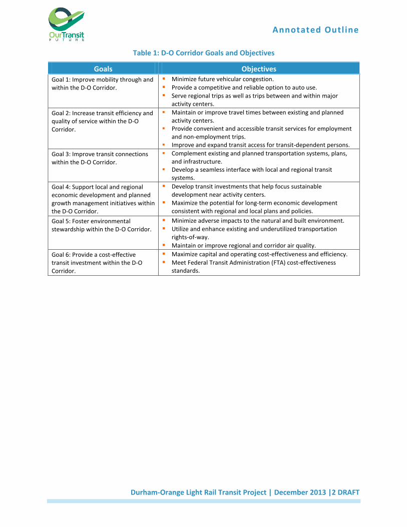
D-O Corridor residents and their elected officials also identified a set of goals and objectives to measure the alternatives’ ability to meet the project’s purpose and needs (see Table 1).
Annotated Outl ine
Durham-Orange Light Rail Transit Project | December 2013 |2 DRAFT
Table 1: D-O Corridor Goals and Objectives
Goals Objectives
Goal 1: Improve mobility through and within the D-O Corridor.
Minimize future vehicular congestion. Provide a competitive and reliable option to auto use. Serve regional trips as well as trips between and within major
activity centers. Goal 2: Increase transit efficiency and quality of service within the D-O Corridor.
Maintain or improve travel times between existing and planned activity centers.
Provide convenient and accessible transit services for employment and non-employment trips.
Improve and expand transit access for transit-dependent persons.
Goal 3: Improve transit connections within the D-O Corridor.
Complement existing and planned transportation systems, plans, and infrastructure.
Develop a seamless interface with local and regional transit systems.
Goal 4: Support local and regional economic development and planned growth management initiatives within the D-O Corridor.
Develop transit investments that help focus sustainable development near activity centers.
Maximize the potential for long-term economic development consistent with regional and local plans and policies.
Goal 5: Foster environmental stewardship within the D-O Corridor.
Minimize adverse impacts to the natural and built environment. Utilize and enhance existing and underutilized transportation
rights-of-way. Maintain or improve regional and corridor air quality.
Goal 6: Provide a cost-effective transit investment within the D-O Corridor.
Maximize capital and operating cost-effectiveness and efficiency. Meet Federal Transit Administration (FTA) cost-effectiveness
standards.
Annotated Outl ine
Durham-Orange Light Rail Transit Project | December 2013 |3 DRAFT
2. Alternatives Considered
This chapter will identify the reasonable alternatives considered throughout the planning process as a
means to meet the objectives of the Purpose and Need defined in Chapter 1. Chapter 2 will summarize
the history of transit corridors studied in the Triangle region and the identification of the D-O Corridor
as the priority transit corridor evaluated in the Alternatives Analysis (AA). This chapter will also describe
the public and agency involvement efforts through the previous planning work. Based on FTA guidance,
the alternatives evaluated in the AA for the D-O Corridor included No-Build, Transportation System
Management (TSM), and Build Alternatives comprised of various alignments and transit technologies
including, but not limited to, bus rapid transit (BRT) and light rail transit (LRT). The Draft Environmental
Impact Statement (DEIS) will include the development and analysis of the three primary alternatives
between UNC Hospitals and east Durham.
2.1 No-Build Alternative
In the National Environmental Policy Act (NEPA) process, the No‐Build Alternative is used as a starting
point to provide a comparison of all Build Alternatives in terms of costs, benefits, and impacts. The No‐
Build Alternative includes all highway and transit facilities that are likely to exist in 2040 based on the
fiscally-constrained 2040 Long Range Transportation Plan (LRTP) and the Durham County and Orange
County Bus and Rail Investment Plans. However, the No-Build Alternative excludes the rail transit
network, which includes the D-O LRT1.
2.2 Build Alternative
The Build Alternative consists of LRT on a new fixed-guideway rail alignment and support facilities. This
alternative represents the Locally Preferred Alternative (LPA) as currently proposed.
a. 17 stations are proposed; refinements to station locations, layouts, and designs will
occur during the DEIS phase of the project.
b. Potential Rail Operation and Maintenance Facility (ROMF) sites will be addressed. Four
sites for the LRT ROMF were identified in the AA: Leigh Village, Farrington, Patterson,
and Cornwallis. A fifth potential ROMF site, Alston, was added based on comments
received during scoping. All of the LRT ROMF alternatives will be evaluated in the DEIS
phase of the project.
The proposed LPA would result in impacts to environmental resources including, but not limited to,
streams, wetlands, natural resources (significant natural heritage areas and wildlife habitats),
floodplains, and federal lands (including those managed for wildlife). Alternative alignment options
1 DCHC MPO 2040 MTP, http://www.dchcmpo.org/index.php?option=com_content&task=view&id=96&Itemid=35
Durham County Bus and Rail Investment Plan, http://ourtransitfuture.com/durham-county-bus-and-rail-investment-plan/ Orange County Bus and Rail Investment Plan and appendices, http://ourtransitfuture.com/orange-county-transit-plan/.
Annotated Outl ine
Durham-Orange Light Rail Transit Project | December 2013 |4 DRAFT
avoiding or minimizing impacts to these resources will be developed and described in this section of the
DEIS.
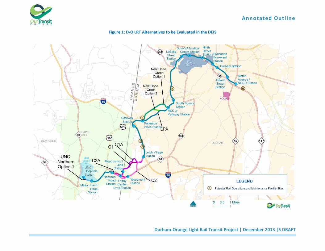
The DEIS will address both alignment and station alternatives for crossing Little Creek and US Army Corps of Engineers (USACE) property in the vicinity of Alternatives C1, C1A, C2, C2A, including alignment options along NC 54. Alternatives for the proposed crossing of New Hope Creek and Sandy Creek, including alignment options along US 15/501 (Figure 1), will also be studied.
2.3 TSM
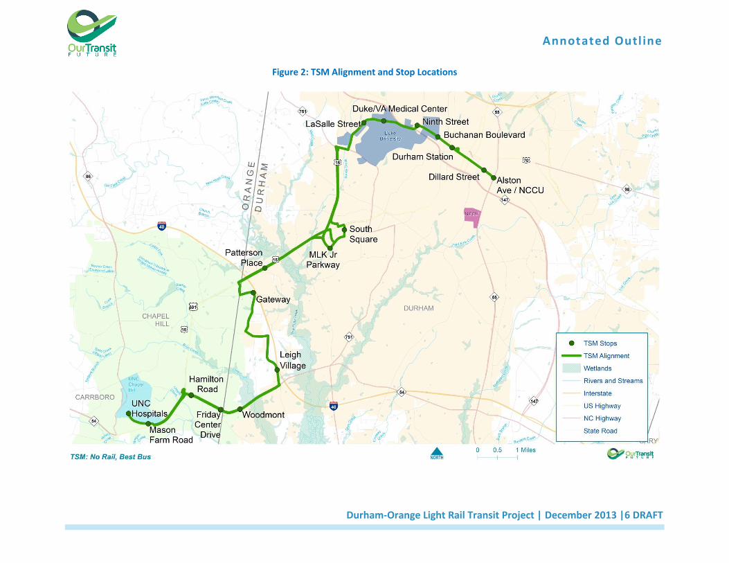
The TSM Alternative consists of an enhanced bus network that provides a level of transit service roughly
equivalent to that of a fixed-guideway transit service (Figure 2). TSM was advanced from the AA process
and was identified as an alternative during the project scoping process prior to the implementation of
Map-21. While the TSM is no longer required to be included as a “baseline” alternative to which other
alternatives will be compared, it will nevertheless be addressed in the DEIS since it was included in the
project scoping process.
Annotated Outl ine
Durham-Orange Light Rail Transit Project | December 2013 |5 DRAFT
Figure 1: D-O LRT Alternatives to be Evaluated in the DEIS
Annotated Outl ine
Durham-Orange Light Rail Transit Project | December 2013 |6 DRAFT
Figure 2: TSM Alignment and Stop Locations
Annotated Outl ine
Durham-Orange Light Rail Transit Project | December 2013 |7 DRAFT
3. Transportation
Chapter 3 will address existing and projected transportation conditions in the D–O Corridor and the
impacts associated with the implementation of a major transit investment. Transportation conditions
will be described in terms of travel patterns, public transit service, street and highway facilities, freight
and passenger rail service, airports, bicycle and pedestrian facilities, and parking.
3.1 Regional Travel Patterns
The potential effects on travel patterns within the region and the area to be served by the proposed transit system will be described in this section.
3.2 Public Transportation
This section will present an analysis focused on projected ridership, rail and bus operating plans, travel
speeds, travel times, service coordination, transit vehicles, and level of service for each of the
alternatives.
3.3 Roadways
This section will describe the existing street and highway network, evaluate traffic impacts that would result from implementation of the project, and identify mitigation measures where applicable.
3.4 Parking
This section of the DEIS will include an assessment of the existing parking and any proposed changes to parking.
3.5 Freight and Passenger Rail
Existing freight and passenger rail service within the D-O Corridor and potential impacts to this service will be described. The eastern-most 2.8 miles of the proposed D-O LRT alignment are located within the state-owned railroad right-of-way which is managed by the North Carolina Railroad Corporation (NCRR). The NCRR Corridor is used by Norfolk Southern Railroad freight service and Amtrak passenger rail services.
3.6 Airports
This section will address airports located within five miles of the D-O Corridor. Horace Williams Airport is
a general aviation airport located in Chapel Hill. Currently, the Federal Aviation Administration (FAA)
Airport Improvement Program is administered by the North Carolina Department of Transportation
(NCDOT) Division of Aviation on behalf of the FAA for all general aviation airports located in North
Carolina. Although the airport is no longer in use, it has not been decommissioned. To ensure no hazards
to aviation are created by the proposed project, the analysis will ensure that all design and construction
elements of the project, including any proposed mitigation measures, consider and incorporate the
guidance found in FAA Advisory Circular 150/5200-33B.
3.7 Bicycle and Pedestrian Facilities
Existing and planned bicycle and pedestrian facilities and impacts to these facilities will be described in this section of the DEIS.
Annotated Outl ine
Durham-Orange Light Rail Transit Project | December 2013 |8 DRAFT
4. Affected Environment and Environmental Consequences
4.1 Land Use, Public Policy, and Zoning
This section will include an evaluation of transportation and land use policies as well as the following
potential direct effects of the alternatives on land use:
The affected environment includes several activity centers: UNC, Meadowmont, and East 54 in
Orange County; the Leigh Village planned development, New Hope Commons, Patterson Place,
South Square, Duke University Medical Center, Ninth Street, downtown Durham, and east
Durham in Durham County
Potential economic and joint development opportunities surrounding station locations.
Properties that would be acquired by construction and/or operation of the proposed alternatives.
Other land uses will be identified in the DEIS study and alternatives will be evaluated for
consistency with state, county, and local land use and zoning plans.
4.2 Socio-Economic and Demographic Conditions
This section will include descriptions of existing population and demographics (i.e., gender, age, and
ethnicity), housing and home ownership, and economic conditions (employment, economic output, and
government finance) located within the study area for the proposed alternatives as follows:
Analysis of trends over time and potential of alternative affect those trends.
Discussion of the potential socio-economic effects of the project and its impact on the local
economy. Potential mitigation measures will be included where necessary.
Project effects on economic development in the region and cost savings for transit users vs.
families using automobiles.
Economic impacts will be assessed, particularly for transit oriented development (TOD) and other commercial and residential development.
4.3 Neighborhoods, Community Services, and Community Facilities
This section will address the neighborhoods and communities within the project study area as follows:
Notable neighborhoods and communities along the proposed alignment that may be affected
include, but are not limited to, the Meadowmont community, Downing Creek neighborhood,
Trinity Park, and those neighborhoods in the vicinity of the project terminus at Alston Avenue in
east Durham.
This DEIS will incorporate actions for the protection of the health and safety of children through
compliance with Executive Order 13045, which mandates that federal agencies identify and
assess environmental safety risks that may disproportionately affect children as a result of
implementation of federal policies, programs, activities, and standards.
Potential mitigation measures will also be included where necessary.
Annotated Outl ine
Durham-Orange Light Rail Transit Project | December 2013 |9 DRAFT
4.4 Visual and Aesthetic Considerations
This section will provide a general overview of visual conditions along the D-O Corridor of the proposed alternatives and will identify potential impacts to the visual environment that may arise. This section will then discuss potential mitigation measures related to visual quality. The build alternatives will be evaluated based on views of the project from surrounding communities, views of the communities from the project, and views of the project from other transportation facilities. New visual elements resulting from the proposed project will also be assessed.
4.5 Cultural, Historic, and Archaeological Resources
The archaeological and historic architectural resources within the area of potential effect (APE) for the
D-O LRT will be presented in the DEIS as follows:
The APE will be determined in coordination with the FTA and the North Carolina State Historic
Preservation Office (SHPO) and field reconnaissance will be conducted to identify resources
within the APE.
It will identify the potential effects of the alternatives under study and their associated impacts
in compliance with Section 106 of the Historic Preservation Act.
Historic properties, archeological sites, parklands, and other cultural resources will be identified
and best efforts will be made to minimize or avoid potential impacts.
The DEIS will document consultation with SHPO, Native American Tribes, and other consulting
parties in the determinations of effects, and efforts to minimize potential harm during
construction and operation of the proposed project. Mitigation measures will also be discussed.
The study will address the location of marked and unmarked cemeteries; recognize and account for the historic Meadowmont Farm House on the Rizzo property; identify the location and potential effect to historic resources through downtown Durham, and others that may be within the D-O Corridor.
4.6 Public Parkland and Recreational Areas
Potential direct impacts to parks and recreational resources through the acquisition of land or proximity impacts from the proposed alternatives will be identified. These will include recreational facilities (sports fields, gymnasiums, gamelands), publicly-owned parks and green areas, greenway trails, and wildlife and waterfowl refuges located within the study area for the proposed project. The facilities and services will be recorded and the nature of the project’s effects will be described. During the AA several sites were identified within 50 feet of the proposed D-O LRT alignment including the USACE property in the Meadowmont area. Several parcels owned by Durham County, which have been zoned as Open Space/Recreational, will be addressed in the New Hope Creek area. These resources will be analyzed to determine whether they are protected Section 6(f) and/or Section 4(f) resources. If the proposed project would “use” a Section 4(f) resource, a Section 4(f) Evaluation will be prepared as a separate chapter in the DEIS.
4.7 Natural Resources and Ecosystems
This section will assess the impact of the proposed project on natural resources including wildlife and
habitats within the project study area with a focus on ecologically-sensitive areas and contiguous
expanses of undisturbed lands. The DEIS will identify and document federal and state-listed threatened
Annotated Outl ine
Durham-Orange Light Rail Transit Project | December 2013 |10 DRAFT
and endangered species (both fauna and flora; aquatic and terrestrial) and habitats critical to their
survival as well as other natural resources as follows:
Little Creek Bottomlands and Slopes and New Hope Creek Significant Natural Heritage Areas
(SNHA).
Permanent wildlife lands and gamelands in the study area including Little Creek Waterfowl
Impoundment which serves as mitigation for impacts from the construction of B. Everett Jordan
Lake (a 31,300-acre USACE reservoir and recreational area) and is managed by the NC Wildlife
Resources Commission (NCWRC).
High quality habitats identified as Piedmont Bottomland Forest (on both New Hope and Little
Creeks), Mesic Mixed Hardwood Forest (on Little Creek), and Piedmont Levee Forest (on New
Hope Creek), and the population of Carya laciniosa (big shellbark hickory) in the New Hope
Creek Bottomland Forest SNHA south of US 15/501
The DEIS will evaluate the study area by assessing natural resources including an expanded study area that may not impact natural resources. Habitat connections will be addressed, including the New Hope Creek and Sandy Creek corridor, the piedmont swamp forest ecological corridor connecting Duke Forest and Jordan Game Land, and other conservation measures which address avoiding or minimizing environmental impacts to fish and wildlife resources.
4.8 Water Quality and Hydrology
This section will document the surface water, ground water, wellhead and source water protection
areas, as well as the location, delineation, classification, and type of streams, wetlands and buffers,
floodplains, and other water resources that may be impacted by the alternatives and will document
potential impacts and mitigation measures as follows:
Both state and federal water resources including wetlands associated with the alternatives will
be delineated. Measures to avoid or minimize potential impacts will be identified.
A determination will be made regarding the extent to which properties in the study area are
located within the 100-year floodplain. A detailed analysis of potential changes in existing run-
off patterns will be developed. Design elements will be recommended to mitigate potential
impacts. Specific floodplain/flood storage areas include, but are not limited to those associated
with the Jordan Lake watershed in the vicinities of Little Creek and New Hope and Sandy Creeks.
Impacts to jurisdictional waters of Little Creek and New Hope Creek within the Cape Fear
Watershed will be assessed through the process identified in the USACE and the US
Environmental Protection Agency (EPA) memorandum of agreement (MOA) establishing
procedures for permit authorization in compliance with the Clean Water Act Section 404(b)(1)
Guidelines. For impacts that cannot be avoided, practical mitigation will be provided. Efforts to
minimize unavoidable impacts will be exercised and incorporated into the project design
process.
Jurisdictional delineation and mapping will be provided for the entire corridor and aerial
crossings (bridging) of the proposed project’s unavoidable jurisdictional water crossings.
Annotated Outl ine
Durham-Orange Light Rail Transit Project | December 2013 |11 DRAFT
Crossings of wetland systems to connect logical termini associated with the project purpose will
be addressed and wherever possible made perpendicular and at the narrowest point of the
jurisdictional wetland system.
Characterization of and potential effects on water resources in a watershed context that include
surface water, ground water, wellhead and source water protection areas, soils, topographic
features affecting basin hydrology, existing water quality conditions, and land use patterns
affecting runoff conditions will be addressed.
Potential sediment and erosion impacts will be addressed. Project designs and construction
methods will include highly protective sediment and erosion control best management practices
(BMP) as per the North Carolina Department of Environment and Natural Resources Division of
Water Resources Water Quality Program’s Stormwater Best Management Practices. Morgan
Creek, Little Creek, New Hope Creek, Sandy Creek, and Ellerbe Creek will be evaluated for the
most protective BMPs to be used in accordance with Design Standards in Sensitive Watersheds
(15A NCAC 04B.0124).
The project is within the Jordan Lake and Neuse River Basins, and riparian buffer impacts will be avoided and minimized to the greatest extent possible pursuant to 15A NCAC 2B.0267 and 15A NCAC 2B.0233, respectively. Buffer mitigation will be addressed where applicable.
4.9 Soils and Farmlands
This section will describe the geologic and subsurface conditions within the D-O Corridor, including topography and geology (types of soil/rock, depth to bedrock, groundwater depth), and will identify potential geologic hazards. This section will discuss measures needed to protect geologic and/or topographic features as they relate to the structural integrity of the proposed project. This section will identify and discuss impacts, if any, on natural landmarks and landforms. If necessary, measures to reduce visual impacts on geologic and/or topographic features will also be discussed. This discussion may be cross-referenced in the Visual and Aesthetic Conditions section.
Soils in the project study area will be evaluated as part of the Farmland Protection Policy Act (FPPA). This regulation requires federal agencies to evaluate the impacts of federally funded projects that may involve converting farmlands to nonagricultural uses and to consider alternative actions that would lessen the adverse effects of the lands conversion. The evaluation process will focus on identifying any prime, unique, or statewide important farmlands. National Resources Conservation Service (NRCS) form CPA-106 will be submitted to the State Conservationist to obtain information on the farmland resources. This will cover the immediate construction area, the full parcels that are impacted by construction, and any areas impacted by the construction of park and ride lots, stations, or maintenance facilities.
This section will explain potential impacts to important farmlands along and within the D-O Corridor as to the various constructed project elements: the proposed D-O LRT line, stations, and ROMF. The impacts analysis will describe how the proposed project will convert farmlands to suburban or urban use, particularly at station sites and park-and-ride lots. The avoidance and minimization of impacts will be made to the extent possible. Where impacts are unavoidable, mitigation plans will be developed and incorporated into the DEIS.
4.10 Air Quality and Greenhouse Gases
The potential impact on air quality, compliance with the 1990 Clean Air Act Amendments, and an evaluation of conformity with the North Carolina State Implementation Plan will be documented. This
Annotated Outl ine
Durham-Orange Light Rail Transit Project | December 2013 |12 DRAFT
section will describe the existing air quality within the study area for the proposed alternatives and discuss the National Ambient Air Quality Standards and federal regulations protecting air quality. In addition, projected year (2040) air quality conditions at various intersections and proposed parking facilities associated with the alternatives under consideration will be analyzed in the DEIS. Motor Vehicle Emission Simulator (MOVES) modeling will be used to model air quality impacts. Mitigation measures will be identified.
4.11 Noise and Vibration
This section will describe the locations of potential noise and vibration sensitive receptors within the study area for the proposed alternatives. It will include an analysis of potential noise and vibration impacts on noise and vibration sensitive resources such as schools, hospitals, residences, hotels/motels, natural areas/wildlife habitats, and historic structures associated with the build alternatives. It will also discuss the potential long-term and short-term effects to receptors for the alternatives under consideration. The process for assessing the potential impact for noise and vibration will follow the U.S. Federal Transit Administration (FTA) guidance manual Transit Noise and Vibration Impact Assessment (May 2006). This process involves three levels of assessment: 1) screening, 2) general assessment and 3) a detailed assessment. A screening is typically done for locating project alignments and involves the identification of noise sensitive receptors along a corridor. Mitigation measures will be identified where noise or vibration impacts are predicted.
4.12 Hazardous, Contaminated, and Regulated Materials
The procedures to determine the potential presence for known hazardous and contaminated materials within the study area of the proposed alternatives will be described in this section of the DEIS. In addition, this section will present the results of a corridor-level field review and a search of local, state, and federal databases for known hazardous, contaminated, or regulated materials sites for the alternatives. The DEIS will document any known hazardous wastes or contamination within the study area. Sites requiring further analysis will be identified. Mitigation measures to minimize impacts will be described.
4.13 Safety and Security
This section will describe the efforts of Triangle Transit to provide safe and secure operations of its transit services, vehicles, transit centers, park-and-ride lots, proposed LRT stations, ROMF, and administrative facilities associated with the alternatives under study in the DEIS. Mitigation will be identified as necessary.
4.14 Energy Use
This section will quantify the expenditure of energy associated with the construction, maintenance, and operation of transportation systems in alternatives under study. Transportation energy use is typically evaluated in terms of direct energy and indirect energy. Direct energy involves energy associated with the direct operation of the transportation system consisting primarily of vehicle propulsion energy. Indirect energy consumption involves the energy expenditures associated with the physical implementation of the transportation system (facility and vehicle construction).
Transportation energy consumption in the state of North Carolina and the Triangle region will be documented. Direct energy consumption of the No-Build and other alternatives will be evaluated as well as indirect energy consumption. Energy consumption measures the net impact on energy savings as a
Annotated Outl ine
Durham-Orange Light Rail Transit Project | December 2013 |13 DRAFT
result of changes in automobile travel in the region offset in part by the energy requirements for operation of the proposed service.
4.15 Climate Change and Adaptation Planning
This section will address the effects of climate change and how the FTA capital investment in the proposed high-capacity transit system would be protected against extreme weather events such as flooding and heat waves that may affect transit infrastructure and passenger comfort.
The FTA issued a Policy Statement on Climate Change Adaptation on May 2011, “Integration of Climate Change Adaptation into FTA Planning, Operations, Policies, and Programs.” The policy states that the FTA will integrate consideration of climate change impacts and, to the extent practicable, the adaptation of the planning, operations, policies, and programs of the agency in order to ensure proper stewardship of the federal investment in public transportation systems for the safety of the traveling public, mobility, and to maintain a state of good repair. The DEIS will address climate change adaptation planning and will also address the North Carolina Climate Change Adaptation Strategy to the extent it is applicable to the proposed project.
4.16 Acquisitions, Relocations, and Displacements
This section describes the potential property acquisitions, relocations, and displacements for the
proposed alternatives. "Full acquisitions" entail the purchase of an entire parcel, whereas “partial
acquisitions” entail the purchase of a portion of a parcel. “Displacements and Relocations” occur when
individuals are physically displaced from the land on which they reside, conduct business, or use for
farming operations.
The Uniform Relocation Assistance and Real Property Acquisition Policy Act of 1970 (Uniform Act) provides for uniform and equitable treatment of persons displaced from their homes, businesses, or farms by federal and federally assisted programs, and establishes uniform and equitable land acquisition policies. The Uniform Act ensures that property owners receive fair market value for their property and that displaced persons receive fair and equitable treatment and do not suffer disproportionate injuries because of programs designed for overall public benefit. The North Carolina Relocation Assistance Act (N.C.G.S. §§ 133-5 through 133-18) and the Municipal Codes of the City of Durham and the Town of Chapel Hill contain regulations that also ensure property owner protections.
4.17 Utility Impacts
Utilities within the D-O Corridor and potential conflicts with the project build alternatives will be identified in this section of the DEIS. This section will also identify the utility owners, both public and private, and document coordination activities to be undertaken during future phases of the project.
4.18 Environmental Justice, Limited English Proficiency, and Title VI
This section of the DEIS will document the incorporation of principles of environmental justice
(Executive Order 12898) and Title VI of the Civil Rights Act of 1964, which prohibit discrimination by
recipients of federal financial assistance on the basis of race, color, and national origin, including
matters related to language access for limited English proficient persons. Documentation will be
prepared in accordance with Environmental Justice Policy, Guidance for Federal Transit Administration
Recipients, FTA Circular 4703.1. The DEIS will assess project benefits and impacts on study area
neighborhoods and communities with specific attention paid to minority, low-income, and limited-
Annotated Outl ine
Durham-Orange Light Rail Transit Project | December 2013 |14 DRAFT
English language proficient populations such as those already identified in the east Durham section of
the proposed project.
4.19 Construction Impacts
Anticipated construction impacts and mitigation measures for the build alternatives will be summarized
in this section. A qualitative analysis will be performed to identify construction impacts in order to
determine where preventative measures to minimize the adverse impacts of construction activities
might be warranted. Since the No-Build Alternative would not include construction activities, it will not
create any construction-related impacts.
Impacts to the natural and built environments will be anticipated during construction of the build
alternatives.
Transportation, traffic, parking, airports, land use, community facilities and services, businesses,
displacement and relocation, visual and aesthetic qualities, neighborhoods, environmental justice, air
quality, noise, vibration, natural resources, water resources, cultural resources, parklands, energy,
hazardous and contaminated materials, and safety and security will be addressed.
4.20 Secondary and Cumulative Effects
This section will assess the secondary (indirect) effects and cumulative effects of the proposed
alternatives when added to the past, present, and reasonably foreseeable future actions of related
projects in the study area. This section will also include a discussion of the recommended mitigation
measures where necessary. The No-Build Alternative will not be included in this assessment, as there
would not be any actions likely to result in secondary or cumulative effects.
The regulations promulgated by the Council on Environmental Quality define “indirect effects” as
“effects which are caused by the [proposed] action and are later in time or farther removed in distance,
but are still reasonably foreseeable. Indirect effects may include growth inducing effects and other
effects related to changes in the pattern of land use, population density, or growth rate” (40 C.F.R. §
1508.8(b)). The transportation and land use goals, plans, and regulations identified within the D-O
Corridor provide a platform for assessing the project’s indirect and cumulative effects.
Particular attention will be paid to the principles of environmental justice (Executive Order 12898) and
Title VI of the Civil Rights Act of 1964 with respect to indirect and cumulative impacts.
Indirect impacts may include growth inducing effects and other effects related to induced changes in the
pattern of land use, population density, or growth rate, and related effects on air, water, and other
natural systems, including ecosystems.
Potential indirect and cumulative effects throughout the entire project corridor will be addressed in the
DEIS and particular attention will be paid to the Jordan Lake watershed and SNHAs on Little Creek, New
Hope Creek, and Sandy Creek. Potential effects that will be addressed include fragmentation of habitats,
disruption of animal movements, growth of invasive species, effects to floodplains, potential effects on
water quality, and connections between the Jordan Game Land, Duke Forest, and New Hope Creek
Preserve.
Cumulative impacts result from the incremental impact of the action when added to other past, present, and reasonably foreseeable future actions regardless of what agency (federal or non-federal) or person
Annotated Outl ine
Durham-Orange Light Rail Transit Project | December 2013 |15 DRAFT
undertakes such other actions. Cumulative impacts can result from individually minor but collectively significant actions taking place over a period of time.
Evaluation of cumulative impacts of this project will assess the additive effects of past, present, and reasonably foreseeable infrastructure and development projects throughout the project corridor. Particular attention will be paid to development activities occurring around the margins of Little Creek, New Hope Creek, and Sandy Creek.
4.21 Resources Considered
This section will list the resources that were considered during scoping and which will unlikely be impacted by the proposed project. These resource areas will not be described in detail in the DEIS. Rather, the discussion will include a brief explanation about why environmental impacts are unlikely. Citations will be made to correspondence with resource agencies, database surveys, and any preliminary field investigations.
Annotated Outl ine
Durham-Orange Light Rail Transit Project | December 2013 |16 DRAFT
5. Section 4(f)
Documentation of compliance with Section 4(f) is required for transportation projects that may receive
federal funding and/or discretionary approvals through one or more agencies of the U.S. Department of
Transportation, including the Federal Railroad Administration (FRA), the Federal Highway Administration
(FHWA), and/or the FTA.
A Section 4(f) evaluation will be conducted pursuant to federal regulations codified in 23 U.S.C. § 138 and 49 U.S.C. § 303 and implemented through 23 C.F.R. § 774 as of April 2008, which were originally enacted as Section 4(f) of the U.S. Department of Transportation Act of 1966 and are still commonly referred to as “Section 4(f).”
Annotated Outl ine
Durham-Orange Light Rail Transit Project | December 2013 |17 DRAFT
6. Financial Analysis
6.1 Capital Costs
This section will discuss the anticipated capital costs associated with each of the proposed alternatives. The analysis will include identification of potential funding sources to cover the capital costs associated with each of the build alternatives. The analysis will build upon the financial plan developed as part the New Starts submission for the D-O LRT.
6.2 Operating and Maintenance Costs
In addition to capital costs, each of the alternatives has associated reoccurring operating and maintenance costs. These costs will be quantified on an annual basis for comparison between alternatives. This section will also identify the sources of revenue to cover the on-going costs associated with each alternative. Similar to the capital costs, the operating and maintenance cost section will build upon the financial plan developed for the New Starts submission.
Annotated Outl ine
Durham-Orange Light Rail Transit Project | December 2013 |18 DRAFT
7. Evaluation of Alternatives
This chapter will evaluate how the proposed alternatives would meet the Purpose and Need from Chapter 1 and evaluate the effectiveness of the alternatives under consideration. The information in this chapter is derived from the other chapters of the DEIS and provides the basis for decision-makers and the public to assess the benefits, costs, and environmental consequences of the alternatives against the goals of the proposed project. Equity considerations and trade-offs will also be presented.
Annotated Outl ine
Durham-Orange Light Rail Transit Project | December 2013 |19 DRAFT
8. Public Involvement and Agency Coordination
This chapter will summarize the public involvement and agency coordination processes and the results of these activities. It describes the early and continuous efforts to involve the general public, interested and affected parties, stakeholders, and federal, state, and local agencies. Public involvement and agency coordination includes the review and selection of alternatives, identification of topics assessed in the DEIS, and the minimization, reduction, or avoidance of potential social, economic, and environmental impacts.

Annotated Outl ine
Durham-Orange Light Rail Transit Project | November 2013 |A-1 DRAFT
Appendices The order of appendices will be determined as documentation progresses and will include, at a minimum, the following subjects:
Index
Glossary
Environmental Justice Analysis
Plans and Profiles
Agency Correspondence
Public Correspondence
Acquisitions and Easements
Technical Reports
List of Preparers
Distribution List
Legal Regulation Context/Methods
References