Embed Size (px)
Citation preview

Annexure-1
Comprehensive details about Manipur State and its Environmental &
Social Sensitivities’
Manipur State -Background
Manipur literally meaning “A
jewelled land” nestle deep within
a lush green corner of North East
India. This State lies between at
latitude of 230 50’N to 250 42’N
and longitude of 92058’E -94045’E.
The state is bounded by Nagaland
(204Km) in the north, Mizoram
(95Km) in the south, Assam
(204.1Km) in the west, and by the
International borders of the
country Burma/Myanmar352Km)
in the east as well as in the south.
The state capital is Imphal, located
in the centre of the state. The total
area covered by the state is about
22,347 km². The capital lies in an oval-shaped valley of approximately 700 square miles (2238km2)
surrounded by blue mountains and is at an elevation varies from 790 metres to 2020 m above the
sea level. The slope of the valley is from north to south. The mountain ranges prevent the cold winds
from the north from reaching the valley and bar cyclonic storms originating from the Bay of Bengal.
Like other north-eastern states, it is largely isolated from the rest of India. Besides air services,
National Highway NH-102 links Manipur with the rest of the country through the railway stations at
Dimapur in Nagaland at a distance of 215 km from Imphal. National Highway 37 also connects
Manipur with another railway station at Silchar in Assam, which is 269 km away from Imphal. The
road network of Manipur, with a length of 8648Km (with surfaced & un-surfaced as 4573 and 4075
Km approx. respectively) connects all the important towns and distant villages.
Manipur existed as a princely State in its early stage and involved in a number of disputes with its
neighbour Burma (Myanmar ). As per the Peberton Report, 1835, the territory of Manipur was very
large as compared to the present one. It had never been static rather fluctuated at various times of
different kings. King Pamheiba generally known by his other name Garibaniiwaj, was one of the
great conquerors of Manipur. During his reign the Manipuris had acquired very considerable power.
In the years 1725, 1735, 1738 and 1749, King Garibaniwaj repeatedly invaded Burma (now
Myanmar), defeated Burmese Armies and devastated many parts of Burma. Manipur also faced
Burmese invasion in her later period say in the year 1890 which led the so called seven years
devastation in her history.
During this period the then king Gambhir Singh of Manipur took shelter in Cachhar district of
Assam. There he re-organised the army with the assistance of the British and ousted the Burmese
from Manipur. Slowly, the British started interfering in the administration of Manipur. This
ultimately led to a full fledged war with the British in 1891. The Manipuri heroes faced the
wellarmed (with guns) and massive British forces with swords and spears. The last phase of this
battle was fought at Khongjom and ended on 23rd April 1891. The Manipuri forces at Khongjom, led
by Major Paona were defeated eventually by the British forces. Many soldiers, including Major
Paona himself, had laid down their lives in the battle field. So this day, the 23rd April has been
commemorated every year by the Manipuris as “Khongjom Day“ by delcaring a state holiday.
After the battle of Khongjom , the palace “Kangla” was captured by the British and subsequently
Yuvraj Tikendrajit along with General Thangal were executed at a public place, on 13th August
1891.This day is still remembered and observed as “The Patriots Day“ since 1891,.After the defeat in
the war, Manipur came under British rule.
Another significant event is that the first free Indian tricolour flag was hoisted on the Indian soil at
Moirang (45 k.m. from Imphal) in Manipur on 14th April, 1944 by the I.N.A. led by Netaji
Subashchandra Bose. Again in the second world war, Manipur was in the scene of many fierce
battles between the Japanese and Allied forces. Many soldiers and officers of the Allied forces lost
their lives in these battles and their final resting places are still maintained in two cemeteries by the
British War Graves Commission at Imphal in Manipur.
In the year 1947 on August 15, Manipur regained her lost political status of a Sovereign independent
Kingdom. The Maharaja of Manipur enacted the Manipur Constitution Act ,1947, establishing a

democratic form of government with the Maharaja as the Executive Head and an elected legislative
assembly.
Shortly after this, on 15th October 1949 Manipur was merged into India through a merger agreement
between the Government of India and the then Maharaja of Manipur and ended the era of the
independent kindgom of Manipur. Hereafter, Manipur became a part of the Indian union. The State
achieved its statehood in the year 1972.
The 73rd and 74th Constitutional Amendments Acts marked a new era in the federal democratic set
up of the country so far as it conferred constitutional status to the panchayats and municipalities and
recognized them as the third tier of Government. The Constitutional amendment provide for
devolution of powers and responsibilities with respect to preparation of plans and programmes for
economic development and social justice and implementation of 29 subjects and 18 subjects listed in
XI and XII Schedule of the Constitution of India. Post 73rd Constitutional Amendment the
Government enacted the Manipur Panchayati Raj (MPR) Act and established a two-tier Panchayati
Raj Institutions (PRIs) system at the village and district levels. The State has 9 districts of which 5
districts are located in the hill areas and 4 districts are spread out in the valley. As on March 2012
there were 4 Zilla Parishads and 165 Gram Panchayats in the State. Consequent upon the 74th
Constitutional Amendment the Government enacted the Manipur Municipality Act 1994.
There are three categories of Urban Local Bodies (ULBs) in the State e.g.Municipal Councils (MCs),
Nagar Panchayats (NPs) and Small Town.
However, the state is unique and distinguished by the existence of separate legislative, governance
and judiciary systems for tribal areas. Meeteilon (Manipuri) and English languages are official
language of the State. The present administrative setup of state given below.
Administrative Setup in Manipur
Sl.
no. Districts
Area
(km2) Population Headquarters
1. Bishnupur 530 240,363 Bishnupur
2. Churachandpur 4570 271,274 Lamka
3. Chandel 3313 144,028 Chandel
4. Imphal East 709 452,661 Porompat

5. Imphal West 519 514,683 Lamphelpat
6. Senapati 3271 354,972 Senapati
7. Tamenglong 4391 140,143 Tamenglong
8. Thoubal 514 420,517 Thoubal
9. Ukhrul 4544 183,115 Ukhrul
Source: Census 2011
Administration in Tribal Areas:
The administrations of the Tribal areas are carried out by the Deputy Commissioners concerned, who
on the other hand act as District Magistrates with support of the District level officer and Block
Development officers.
At the District level, there are Autonomous Districts Councils (ADCs). There are two (2) ADCs in
the Senapati District and one ADC in each of the remaining hill districts constituted under the
Manipur (Hill Areas) Districts Councils Act, 1971.
The above Act “The Manipur (Hill Areas) District Council Act, 1971,” passed by the Parliament
paved the way for establishment of six Autonomous District Councils in Manipur. In accordance
with the powers vested on the Governor of Manipur, following six Autonomous Districts Councils
were constituted on 14th February, 1972:
1. Chandel Autonomous District Council,
2. Churachandpur Autonomous District Council,
3. Sadar Hills Autonomous District Council, Kangpokpi
4. Manipur North Autonomous District Council, Senapati
5. Tamenglong Autonomous District Council,
6. Ukhrul Autonomous District Council.
In accordance with this Act Autonomous Hill District Councils (AHDC) of Manipur are empowered
to maintain and manage of property: movable and immovable, and institutions under their
jurisdiction (e.g. in the field of agriculture, animal husbandry, community development, social and
tribal welfare, village planning, management of any forest except RF, regulation of the Jhum /
shifting cultivation or any other matter.)

At the State level there is Hill Area Committee constituted under the Manipur Legislative Assembly
(Hill Areas Committee) order, 1972. The Hill areas Committee comprises of all M. L. As elected
from the hill areas of the State as its members. The members then elect Chairman and Vice Chairman
and other functionaries through nomination/consensus. This is the highest body in the State at the
legislative level to oversee the planning, implementation and monitoring of all development activities
in the hill areas of the State.
1. Environment Baseline
2.1 Land use in Manipur
The size of the cultivated area is about 7.41% only of the total geographical area of the State. Of this
total cultivated area, 52% is confined to the valley. Therefore, half of the total valley area which
accommodates 67% of the total population is occupied for agriculture purposes. The pressure on land
in the valley is thus quite conspicuous.
Agriculture and allied activities are the backbone of the state's economy. Agriculture being the
main occupation of the people of Manipur, it has an important place in the economy of the state.
Agriculture sector contributes a major share to the total state domestic product and provides
employment to about 52.19 percent of the total workers in Manipur. In fact, the state domestic
product fluctuates depending on the performance of agriculture sector. Despite the crucial
importance of this primary sector in the state's economy, the irregular and erratic behavior of
monsoon accompanied by inadequate irrigation facilities have resulted in severe fluctuations in
agriculture production. Agriculture becomes a living proposition rather than a commercial
proposition. Thus, from the view point of employment and income, agriculture plays a very
crucial role in the state's economy. Land use pattern of the State is illustrated in Table below.
Table- Land Use Pattern
Land Use Area in ‘000 ha Percentage
Total geographical area 2,233
Reporting area for land utilization 2142 100.00
Forests 1742 81.33
Not available for cultivation 27 1.26
Permanent pastures and other grazing lands 1 0.05
Land under misc. Tree crops and groves 6 0.28
Culturable wasteland 1 0.05

Fallow lands other than current fallows 0 0.00
Current fallows 0 0.00
Net area sown 365 17.04
Source: Land Use Statistics, Ministry of Agriculture, GoI, 2011
2.2 Soil
The soil of Manipur belong to 4 orders, 8 suborders, 13 greatgroups and 23 subgroups. It is observed
that the Inceptisols are the dominant soils followed by Ultisols, Entisols and Alfisols and occupy
38.4%, 36.4%, 23.1% of the total geographical area of the State, respectively. Lake and marshy land
occupy 1.9 percent. The area- wise distribution of soil at order and suborder levels of Taxonomy are
given below.
1. Distribution of Soil Order of Manipur
Sl. No Soil order Suborder Area('000 ha) Percent of TGA
1. Inceptisols 858.3 38.4
Ocrepts 654.6 29.3
Acrepts 203.7 9.1
2. Ultisols 811.0 36.4
Humults 374.0 16.8
Udults 436.9 19.6
3. Entisols Orthents 515.6 23.1
4 Alfisols Udalfs 3.8 0.2
5 Miscellaneous Marshy land 42.4 1.9
Total 2231.0 100.0 Source: www.hortimanipur.nic.in
2.3 Geology and Mineral resources
Geology
The geological framework of Manipur including Indo-Burma range along its eastern frontier is
closely linked up with the evolution of Neogene Surma basin, Inner Palaeogene fold belt and
Ophiolite suture zone. The ophiolite belt occurring along Indo-Myanmar border in Manipur, forms a
part of Naga-Arakan Yoma flysch trough of Upper Cretaceous-Middle Miocene age. Geological data
collected so far mainly relates to Ophiolite zone and adjoining terrain. A large part of the state is yet
to be covered by systematic geological mapping. About 64% of the total area of the state has been
covered by systematic geological mapping on 1: 50,000 scale. These are the main mineral-bearing
areas which have already been covered. The study of the rock formations in and around ophiolite belt
elucidates and helps in understanding the broad stratigraphy and structure of the whole terrain.

Available information brings forth a geological picture depicting the spread of Tertiary rocks over
the entire state with small patches of Quaternary sediments in the central part (e.g. Imphal valley)
and a long narrow N-S trending ophiolite belt towards the eastern margin of the state. It, thus,
emerges that geotectonically three distinct domains exist which are: (1) Neogene Surma basin, (2)
Inner Palaeogene fold belt and (3) Ophiolite zone associated with Late Mesozoic-Tertiary sediments.
Mineral Resources
The principal minerals of some economic significance in Manipur are limestone, chromite,
dimension stone, lignite and clay. The limestones occur in Upper Disang and Ophiolite zone. The
important deposits are located at Ukhrul(25° 06' 45'' : 94° 27' 30''), Hungdung (25° 03' 00'' : 94° 20'
30''), Khangoi (25° 03' 07'' : 94° 21' 50''), Lambui (25° 00' : 94° 16'), New Paoyi and Narum(24° 28'
45'' : 94° 19' 25''). Chromite is reported mainly from Ukhrul(25° 06' 45'' : 94° 27' 30''), Gamnom(25°
00' 30'' : 94° 27' 30'') and Moreh (24° 14' : 94° 19'') areas. The lignite, associated with clay, occurs in
Kangvai area of Southern Manipur. The other minerals having little or no economic significance
include copper, nickel and cobalt bearing minerals, magnetite, asbestos and salt. Dimension stones
occur in the ophiolite zones and Barail rocks.
2.4 Climate
Manipur is blessed with a clean climate round the year. The state has two main seasons separated by
two transitions: the winter season and the monsoon season. The winter season is from December to
February. Then is the Pre-Monsoon season in the months of March and April. The monsoon season is
from the month of May to September, and the the post-monsoon season in the month of October and
November.
2.5 Temperature
Temperature ranges from sub-zero to 36 degrees Celsius. The maximum temperature in summer is 32
degrees. In winter the weather remains much cold. The temperature goes down below zero degrees.
The region also experiences snowfall.
2.6 Rainfall
The southwest monsoon chiefly determines the weather and rainfall throughout the state. The state
has tropical to temperate climate depending upon elevation. Rainfall varies from 1000 mms to 3500
mms and average rainfall is 1500 mms.
2.7 Humidity

The mean of the daily humidity is highest during the month of July-Sept; which varies from 80-96%
and differs from place to place.
2. 8 Wind Speed
Wind speed more than 20-61 Km. per hour was 2 times in the month of May and total of 8 days
speedy wind blows in a year where as the wind speed between 1-19 km. per hr. is present 243 days a
year during the data of 24 years.
2.9 Environment Sensitiveness
2.9.1 Recorded Forest Area:
Forest classification Area in sq. km. P.C. (%) to Total Forest Area
Reserved Forest 1,467 8.40
Protected Forest 4,171 24.00
Other Forest 11,780 67.60
Total 17,418 100.00
Source: mastec.nic.in
Forest is an integral part of the culture and tradition of Manipur as its protection maintains the
ecology of the State. The State has a geographical area of 22,327 sq. km. of which 17418 sq.km. (78
%) is the recorded forest area; Reserved Forests constitute 8.40%, Protected Forests 24% and Un-
classed Forests constitute 67.60%.
The deforestation for Jhumming (shifting cultivation)is an age-old practice in the hills of Manipur.
But during the last 20 years there is a tremendous increase in the area of Jhum cultivation, mostly in
the dense forest areas caused by rapid increase of population of the tribal living in forest.
There are more than 104 species of animals (fauna) used as age-old medicine and more than 5000
Sacred Groves have been reported. Many of these animals of ethnozoological importance are in
threat due to over exploitation. Moreover, many of the sacred Groves are going to disappear.

Forest Map Manipur
District-wise Forest Cover
Sl.
No.
District Geographi
cal Area
(in km²)
2011 Assessment (Area in km²) Percent
of GA
Scrub
Very
Dense
Forest
Mod.
Dense
Forest
Open
Forest
Total
1. Bishnupur 496 0 1 20 21 4.23 0
2. Chandel 3,313 0 744 2,085 2,829 85.39 0
3. Churachandpur 4,570 37 1,683 2,555 4,275 93.54 0
4. Imphal East 669 0 53 167 220 32.88 0
5. Imphal West 559 0 24 31 55 9.84 0
6. Senapati 3,271 233 870 1,080 2,183 66.74 0
7. Tamenglong 4,391 279 1,784 1,839 3,902 88.86 0
8. Thoubal 514 0 4 52 56 10.89 0
9. Ukhrul 4,544 181 988 2,380 3,549 78.10 1
Grand Total 22,327 730 6,151 10,209 17,090 76.54 1
Source: State Forest Report, 2013
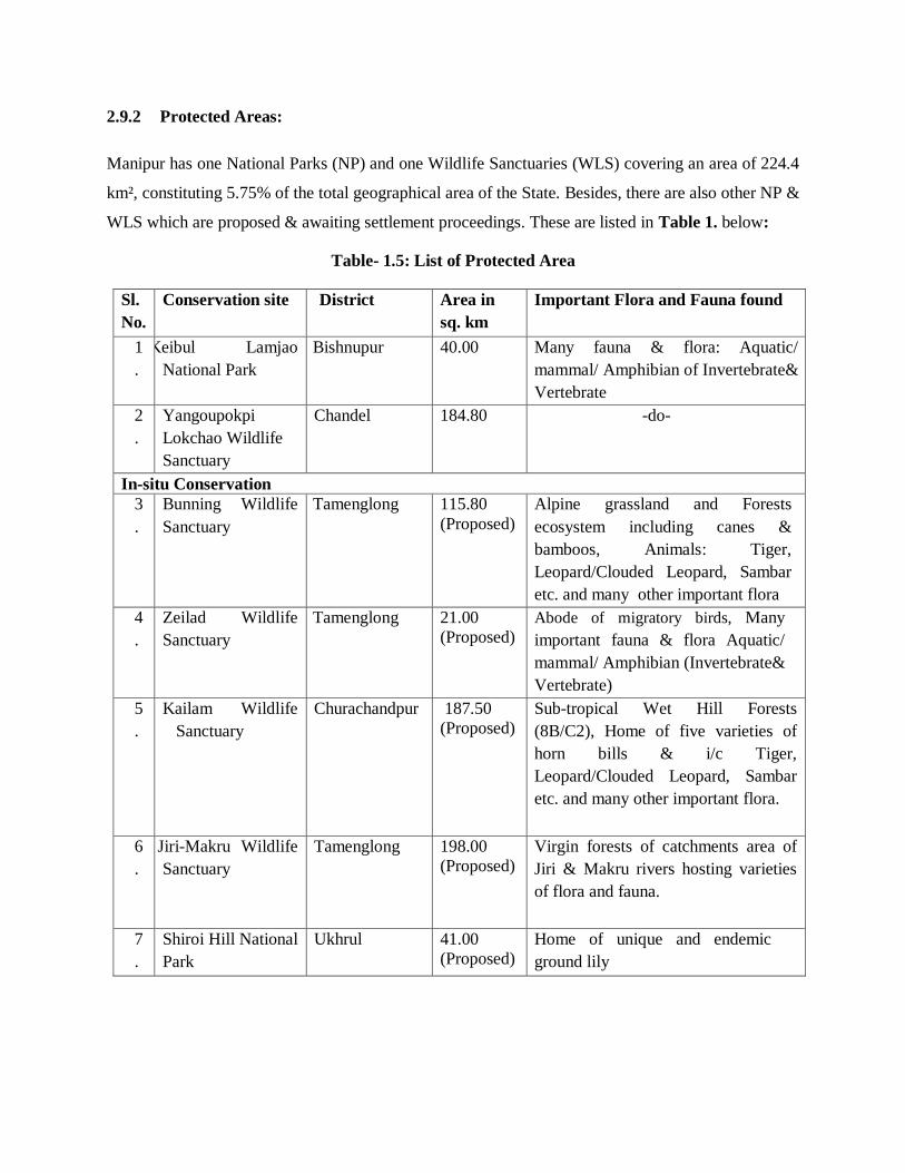
2.9.2 Protected Areas:
Manipur has one National Parks (NP) and one Wildlife Sanctuaries (WLS) covering an area of 224.4
km², constituting 5.75% of the total geographical area of the State. Besides, there are also other NP &
WLS which are proposed & awaiting settlement proceedings. These are listed in Table 1. below:
Table- 1.5: List of Protected Area
Sl.
No.
Conservation site District Area in
sq. km
Important Flora and Fauna found
1
.
Keibul Lamjao
National Park
Bishnupur 40.00 Many fauna & flora: Aquatic/
mammal/ Amphibian of Invertebrate&
Vertebrate
2
.
Yangoupokpi
Lokchao Wildlife
Sanctuary
Chandel 184.80 -do-
In-situ Conservation
3
.
Bunning Wildlife
Sanctuary
Tamenglong 115.80
(Proposed)
Alpine grassland and Forests
ecosystem including canes &
bamboos, Animals: Tiger,
Leopard/Clouded Leopard, Sambar
etc. and many other important flora
4
.
Zeilad Wildlife
Sanctuary
Tamenglong 21.00
(Proposed)
Abode of migratory birds, Many
important fauna & flora Aquatic/
mammal/ Amphibian (Invertebrate&
Vertebrate)
5
.
Kailam Wildlife
Sanctuary
Churachandpur 187.50
(Proposed)
Sub-tropical Wet Hill Forests
(8B/C2), Home of five varieties of
horn bills & i/c Tiger,
Leopard/Clouded Leopard, Sambar
etc. and many other important flora.
6
.
Jiri-Makru Wildlife
Sanctuary
Tamenglong 198.00
(Proposed)
Virgin forests of catchments area of
Jiri & Makru rivers hosting varieties
of flora and fauna.
7
.
Shiroi Hill National
Park
Ukhrul 41.00
(Proposed)
Home of unique and endemic
ground lily

2.9.4 Wetlands:
The National Wetland Atlas 2010, developed by Space Application Centre, Indian Space Research
Organization sponsored by the Ministry of Environment & Forests, Govt. of India, has identified 167
wetlands (≥ 2.25 Ha) and 541 wetlands (<2.25 Ha) which is covering of 63,616 ha i.e. 2.85% of total
geographic area under different types of wetlands like lake / pond (61.5%), river/steam (26.2%),
waterlogged (5.5%) and aquaculture pond. Out of that, 19 (nineteen) important wetlands from 7
(seven) districts of Manipur, including 2 hill wetlands viz. Zaimeng at Senapati and Zailad at
Tamenglong, has been identified by the Directorate of Environment, Government of Manipur, the
State Nodal Agency for conservation of Wetlands in Manipur.
Analysis of wetland status in terms of open water and aquatic vegetation showed that around 71 % of
wetland area is under open water category during post monsoon and 62% during pre-monsoon
respectively. Aquatic vegetation (floating/emergent) occupies around 26 % of wetland area during
post monsoon and 37 % during pre-monsoon respectively.
Loktak Lake largest wetland covering 61% of the wetland regime (468 sq km) within Manipur River
Basin, supporting livelihood of about 1 lakh people living in and around the wetlands. •Traditionally
it is widely used for fisheries and agriculture. It is a source of 105 MW Hydropower. It supports rich
floral and faunal biodiversity including Brow Antlered Deer (Sangai) of Keibul Lamjao National
Park. Loktak Wetland has been identified as Ramsar site under National Wetland Conservation
Program.
3.0 Social Baseline
3.1 Demographic Features
The population of Manipur as per census 2011 was 2570390. Decadal growth of population in the
State during 2001-2011 was 18.65 % and males growth were 17.88 % and females were 19.44 %
respectively..
Basic features of Manipur
Geographical location 23.83ºN and 25.68ºN latitude and 93.03ºE and 94.78ºE longitude.
Area 22,327 Sq. km.
Population 2570390
Population density 115 per sq. km.
Sex ratio 992 females per 1000 males
Literacy rate 68.8%
Decadal Growth percentage 12.5%
Source: Census 2011

3.2 Table below shows the total population of Manipur. Manipur has a population of 2570390. Out of
these about 1290171 are males and remaining 1280219are females. Out of these about 1736236are
settled in rural areas.
Table : Manipur State Population
State TRU Total Population Total Male Total Female
Manipur
Total 2570390 1290171 1280219
Rural 1736236 878469 857767
Urban 834154 411702 422452
Source: Census 2011
3.3 Table below shows the literacy level of Manipur. As per census 2011, about 68.79% are literate.
Table : Manipur State Literacy Level
State TRU Population Literate Male Literate Female
Literate
Manipur
Total 1768181 960015 808166
Rural 1142564 630291 512273
Urban 625617 329724 295893
Source: Census 2011
3.4 Table below shows the SC and ST population of Manipur State as per census 2011. Schedule
Caste population is 3.77% of the total population, whereas Schedule Tribe population is about
35.12% of the total population.
Source: Census 2011
3.5 Table below shows the worker population of Manipur State. About 45.09% of the total
population are working.
Table : Manipur State Worker Population
State TRU Total Work
Population
Total Male
Worker
Total Female
Worker
Manipur
Total 1159053 665463 493590
Rural 813604 460140 353464
Urban 345449 205323 140126
Source: Census 2011
Table : Manipur State Population SC and ST
State TRU Population SC Population ST
Manipur
Total 97042 902740
Rural 47563 791126
Urban 49479 111614