Embed Size (px)
Citation preview
Annex K: COSUMNES COMMUNITY SERVICES
DISTRICT FIRE DEPARTMENT
Sacramento County (Cosumnes Community Services District Fire Department) Annex K.1 Local Hazard Mitigation Plan Update September 2011
K.1 Introduction
This Annex details the hazard mitigation planning elements specific to the Cosumnes
Community Services District Fire Department (Cosumnes Fire Department or CFD), a
participating jurisdiction to the Sacramento County LHMP Update. This annex is not intended
to be a standalone document, but appends to and supplements the information contained in the
base plan document. As such, all sections of the base plan, including the planning process and
other procedural requirements apply to and were met by the District. This annex provides
additional information specific to the Cosumnes Fire District, with a focus on providing
additional details on the risk assessment and mitigation strategy for this community.
K.2 Planning Process
As described above, the Cosumnes Fire Department followed the planning process detailed in
Section 3.0 of the base plan. In addition to providing representation on the Sacramento County
Hazard Mitigation Planning Committee (HMPC), the City formulated their own internal
planning team to support the broader planning process requirements. Internal planning
participants included staff from the following departments:
Fire Operations
Fire Prevention
CSD Administration
CSD GIS
K.3 Community Profile
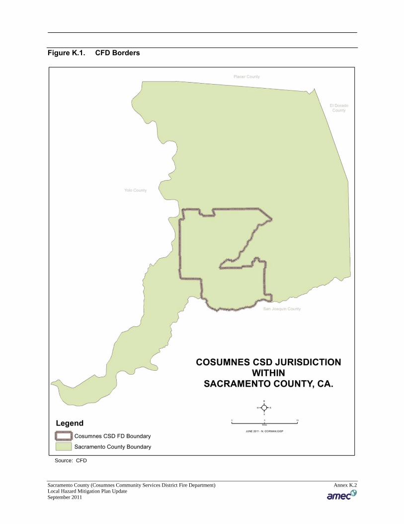
The community profile for the CFD is detailed in the following sections. Figure K.1 displays a
map and the location of the CFD boundaries within Sacramento County.
Sacramento County (Cosumnes Community Services District Fire Department) Annex K.2 Local Hazard Mitigation Plan Update September 2011
Figure K.1. CFD Borders
Source: CFD
Sacramento County (Cosumnes Community Services District Fire Department) Annex K.3 Local Hazard Mitigation Plan Update September 2011
K.3.1 Geography and Climate
Cosumnes Fire Department which provides all risk emergency services to the cities of Elk
Grove, and Galt. Additionally. services are provided to the communities of Sheldon, Pleasant
Grove Laguna, Laguna West, and Franklin. The District has a Mediterranean climate,
characterized by damp to wet, mild winters and hot, dry summers. The wet season is generally
October through April, though there may be a day or two of light rainfall in June or September.
The mean annual temperature is 61.1°F, with monthly means ranging from 45.8°F in December
to 75.4°F in July. Summer heat is often moderated by a sea breeze known as the “delta breeze”
which comes through the Sacramento-San Joaquin River Delta from the San Francisco Bay.
On average, 96 days in the year experience some degree of fog, which usually occurs in the
morning (tule fog). The foggiest months are December and January. Tule fog can be extremely
dense, lowering visibility to less than 100 feet and making driving conditions extremely
hazardous. Chilling tule fog events have been known to last for several consecutive days or
weeks. During tule fog events temperatures do not exceed 50 degrees.
Snowfall is exceptionally rare in the District (at an elevation of only 45 to 47 feet above sea
level). The all-time record snowfall was 3.5 inches on January 4, 1888. Dustings occur every 5–
10 years, with up to an inch accumulation in outlying areas. During especially cold winter and
spring storms, intense showers do occasionally produce a significant amount of hail, which can
create hazardous driving conditions. Significant snow accumulations occur each year in the
foothills located 40 miles (65 km) east of the city.
On average, there are 74 days where the high exceeds 90°F, and 15 days where the high exceeds
100°F; on the other extreme, freezing nights occur 16 nights per year. At Sacramento
International Airport, extremes have ranged from 18°F on December 22, 1990 to 115°F on June
15, 1961.
The average annual precipitation is 21.45 inches. On average, precipitation falls on 62 days each
year in Sacramento region, and nearly all of this falls during the winter months. Average
January rainfall is 3.84 inches, and measurable precipitation is rare during the summer months.
In February 1992, Sacramento region had 16 consecutive days of rain, resulting in an
accumulation of 6.41 inches for the period. A record 7.24 inches of rain fell on April 20, 1880.
On rare occasions, monsoonal moisture surges from the Desert Southwest can bring upper-level
moisture to the Sacramento region, leading
K.3.2 History
The Cosumnes Community Services District Planning Area encompasses the former territory of
six Plains Miwok tribelets along the Cosumnes River drainage and two, possibly three tribelets
along the Sacramento River. In 1850, Elk Grove was established as a hotel stop and a stop for
the stage. It is located about 15 miles south of historic Sutter’s Fort and thus became a
Sacramento County (Cosumnes Community Services District Fire Department) Annex K.4 Local Hazard Mitigation Plan Update September 2011
crossroads for business, entertainment, mail service and agriculture, and acted as home base for
gold miners in nearby communities.
Initially, the town of Elk Grove developed around a stage stop on the Monterey Trail, though
after the railroad passed by east of town, Elk Grove’s center shifted to its present location. “Old
Town” Elk Grove is located about a mile east of State Route 99 (formerly U.S. Route 99, the
north-south artery of the California Central Valley).
America’s first transcontinental highway, the Lincoln Highway, ran through Galt until it was
ultimately replaced by State Route 99. Lincoln Way in central Galt is a remnant of this historic
route. Galt grew around the rail depot and State Route 99 throughout the first half of the
twentieth century. Improvements to State Route 99 in recent years have made Galt more
accessible, which has resulted in increased population and growth to the west and northeast.
The original 1850 Spanish land grant, Rancho del los Moquelumnes, was purchased in 1861 by
Dr. Obed Harvey, considered today as Galt’s founder. His purchase included much of the Dry
Creek Township which was later established as the town of Galt in 1869 by the Western Pacific
Railroad company. A prominent early settler, John McFarland, named the town after his former
home in Ontario, Canada, which was named after a Scottish novelist, John Galt. The
combination of favorable land for agriculture and the proximity to the railroad provided Galt
with the economic support to continue to grow.
With the decline of gold mining in the Sierra Nevada foothills by the end of the eighteenth
century, Galt, like many other Central Valley towns, saw the arrival of miners looking to start
anew in agriculture. The City’s proximity to several major rivers and the water resources of the
Sacramento-San Joaquin River Delta made Galt ideal for the establishment of agriculture early in
California’s history.
Today, Galt is at a strategic location between the growing areas of Sacramento and Stockton.
The city’s proximity to I-5 and SR 99 provides Galt excellent access to the rest of the Central
Valley and California. Despite fast growth in the region, the city continues to maintain its small-
town character while balancing the needs for housing and acknowledging its important
agricultural heritage.
K.3.3 Economy
Studies for foreseeable future point to slow growth in the labor markets which directly impacts
the Cosumnes Fire Department. The Department, which includes the cities of Elk Grove and
Galt, was affected by the subprime mortgage crisis and the decrease in new home construction
which has historically played an important part in the overall local economy. Of the region's five
largest job sectors (government, trade, transportation, utilities, and leisure), three continue to
struggle which in effect has slowed the region's recovery.
Sacramento County (Cosumnes Community Services District Fire Department) Annex K.5 Local Hazard Mitigation Plan Update September 2011
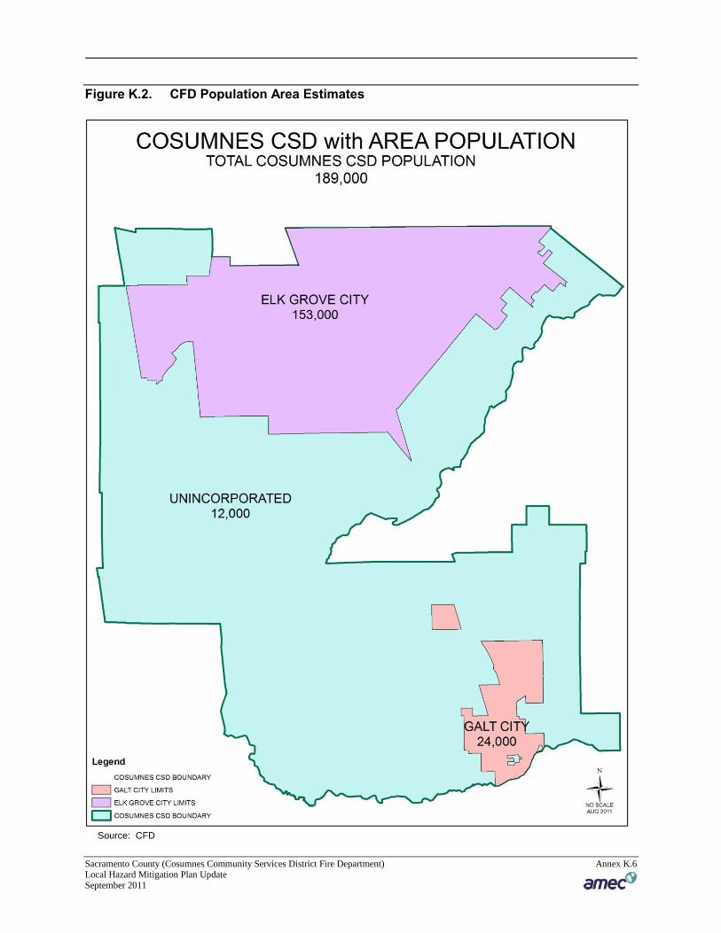
K.3.4 Population
In 2010, the total population for the CFD was estimated at 189,000. Population breakouts are
shown in Figure K.2.
Sacramento County (Cosumnes Community Services District Fire Department) Annex K.6 Local Hazard Mitigation Plan Update September 2011
Figure K.2. CFD Population Area Estimates
Source: CFD
Sacramento County (Cosumnes Community Services District Fire Department) Annex K.7 Local Hazard Mitigation Plan Update September 2011
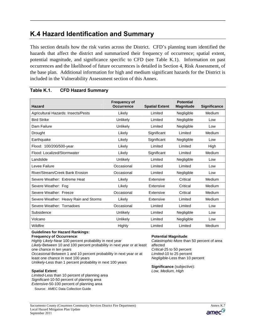
K.4 Hazard Identification and Summary
This section details how the risk varies across the District. CFD’s planning team identified the
hazards that affect the district and summarized their frequency of occurrence; spatial extent,
potential magnitude, and significance specific to CFD (see Table K.1). Information on past
occurrences and the likelihood of future occurrences is detailed in Section 4, Risk Assessment, of
the base plan. Additional information for high and medium significant hazards for the District is
included in the Vulnerability Assessment section of this Annex.
Table K.1. CFD Hazard Summary
Hazard Frequency of Occurrence Spatial Extent
Potential Magnitude Significance
Agricultural Hazards: Insects/Pests Likely Limited Negligible Medium
Bird Strike Unlikely Limited Negligible Low
Dam Failure Unlikely Limited Negligible Low
Drought Likely Significant Limited Medium
Earthquake Likely Significant Negligible Low
Flood: 100/200/500-year Likely Limited Limited High
Flood: Localized/Stormwater Likely Significant Limited Medium
Landslide Unlikely Limited Negligible Low
Levee Failure Occasional Limited Limited Low
River/Stream/Creek Bank Erosion Occasional Limited Negligible Low
Severe Weather: Extreme Heat Likely Extensive Critical Medium
Severe Weather: Fog Likely Extensive Critical Medium
Severe Weather: Freeze Occasional Extensive Critical Medium
Severe Weather: Heavy Rain and Storms Likely Extensive Limited Medium
Severe Weather: Tornadoes Occasional Limited Limited Low
Subsidence Unlikely Limited Negligible Low
Volcano Unlikely Limited Negligible Low
Wildfire Highly Limited Limited Medium
Guidelines for Hazard Rankings: Frequency of Occurrence: Highly Likely-Near 100 percent probability in next year Likely-Between 10 and 100 percent probability in next year or at least one chance in ten years Occasional-Between 1 and 10 percent probability in next year or at least one chance in next 100 years Unlikely-Less than 1 percent probability in next 100 years Spatial Extent: Limited-Less than 10 percent of planning area Significant-10-50 percent of planning area Extensive-50-100 percent of planning area
Potential Magnitude: Catastrophic-More than 50 percent of area affected Critical-25 to 50 percent Limited-10 to 25 percent Negligible-Less than 10 percent Significance (subjective):
Low, Medium, High
Source: AMEC Data Collection Guide
Sacramento County (Cosumnes Community Services District Fire Department) Annex K.8 Local Hazard Mitigation Plan Update September 2011
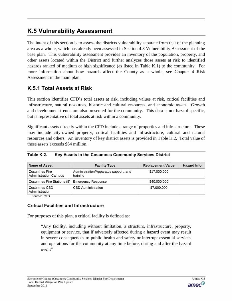
K.5 Vulnerability Assessment
The intent of this section is to assess the districts vulnerability separate from that of the planning
area as a whole, which has already been assessed in Section 4.3 Vulnerability Assessment of the
base plan. This vulnerability assessment provides an inventory of the population, property, and
other assets located within the District and further analyzes those assets at risk to identified
hazards ranked of medium or high significance (as listed in Table K.1) to the community. For
more information about how hazards affect the County as a whole, see Chapter 4 Risk
Assessment in the main plan.
K.5.1 Total Assets at Risk
This section identifies CFD’s total assets at risk, including values at risk, critical facilities and
infrastructure, natural resources, historic and cultural resources, and economic assets. Growth
and development trends are also presented for the community. This data is not hazard specific,
but is representative of total assets at risk within a community.
Significant assets directly within the CFD include a range of properties and infrastructure. These
may include city-owned property, critical facilities and infrastructure, cultural and natural
resources and others. An inventory of key district assets is provided in Table K.2. Total value of
these assets exceeds $64 million.
Table K.2. Key Assets in the Cosumnes Community Services District
Name of Asset Facility Type Replacement Value Hazard Info
Cosumnes Fire Administration Campus
Administration/Apparatus support, and training
$17,000,000
Cosumnes Fire Stations (8) Emergency Response $40,000,000
Cosumnes CSD Administration
CSD Administration $7,000,000
Source: CFD
Critical Facilities and Infrastructure
For purposes of this plan, a critical facility is defined as:
“Any facility, including without limitation, a structure, infrastructure, property,
equipment or service, that if adversely affected during a hazard event may result
in severe consequences to public health and safety or interrupt essential services
and operations for the community at any time before, during and after the hazard
event”
Sacramento County (Cosumnes Community Services District Fire Department) Annex K.9 Local Hazard Mitigation Plan Update September 2011
This definition was refined by separating out three categories of critical facilities as further
described in Section 4.3.1 of the base plan. An inventory of critical facilities in the CFD is
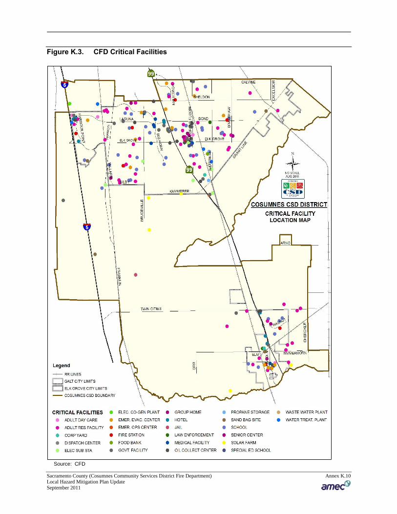
provided in Table K.3 and shown in Figure K.3.
Table K.3. CFD Critical Facilities: Summary Table
CF Definition Category Type Count
Essential Services Facilities Corporation Yard 2
Essential Services Facilities Dentention Basin 24
Essential Services Facilities Dispatch Center 2
Essential Services Facilities Emergency Evacuation Shelter 12
Essential Services Facilities Emergency Operations Center 2
Essential Services Facilities Fire Station 8
Essential Services Facilities Government Facilities 20
Essential Services Facilities Medical Health Facility 10
Essential Services Facilities Law Enforcement 3
Essential Services Facilities Sand Bag 7
Essential Services Facilities Jail 1
Essential Services Facilities State And Fed Facilities 4
Essential Services Facilities Wastewater Treatment Facility 2
Essential Service Facilities Electrical Sub -Stations 12
Essential Service Facilities Water Treatment Facility 5
Essential Service Facilities Co-Generation Plant 1
Essential Service Facilities Photovoltaic Farm 5
Essential Service Facilities Food Bank 1
Essential Service Facilities Senior Center 1
Essential Service Facilities Cal Trans Service Center 1
At Risk Population Facilities Adult Residential 54
At Risk Population Facilities Assisted Living Centers 57
At Risk Population Facilities Day Care Center 37
At Risk Population Facilities Group Home 6
At Risk Population Facilities Hotel 8
At Risk Population Facilities Infant Center 1
At Risk Population Facilities Public and Private Schools 45
At Risk Population Facilities Adult Day Care 6
At Risk Population Facilities Special Education School 1
Hazardous Materials Facilities Oil Collection Centers 1
Hazardous Materials Facilities Large Propane Storage 1
Total: 340
Source: CFD
Sacramento County (Cosumnes Community Services District Fire Department) Annex K.10 Local Hazard Mitigation Plan Update September 2011
Figure K.3. CFD Critical Facilities
Source: CFD
Sacramento County (Cosumnes Community Services District Fire Department) Annex K.11 Local Hazard Mitigation Plan Update September 2011
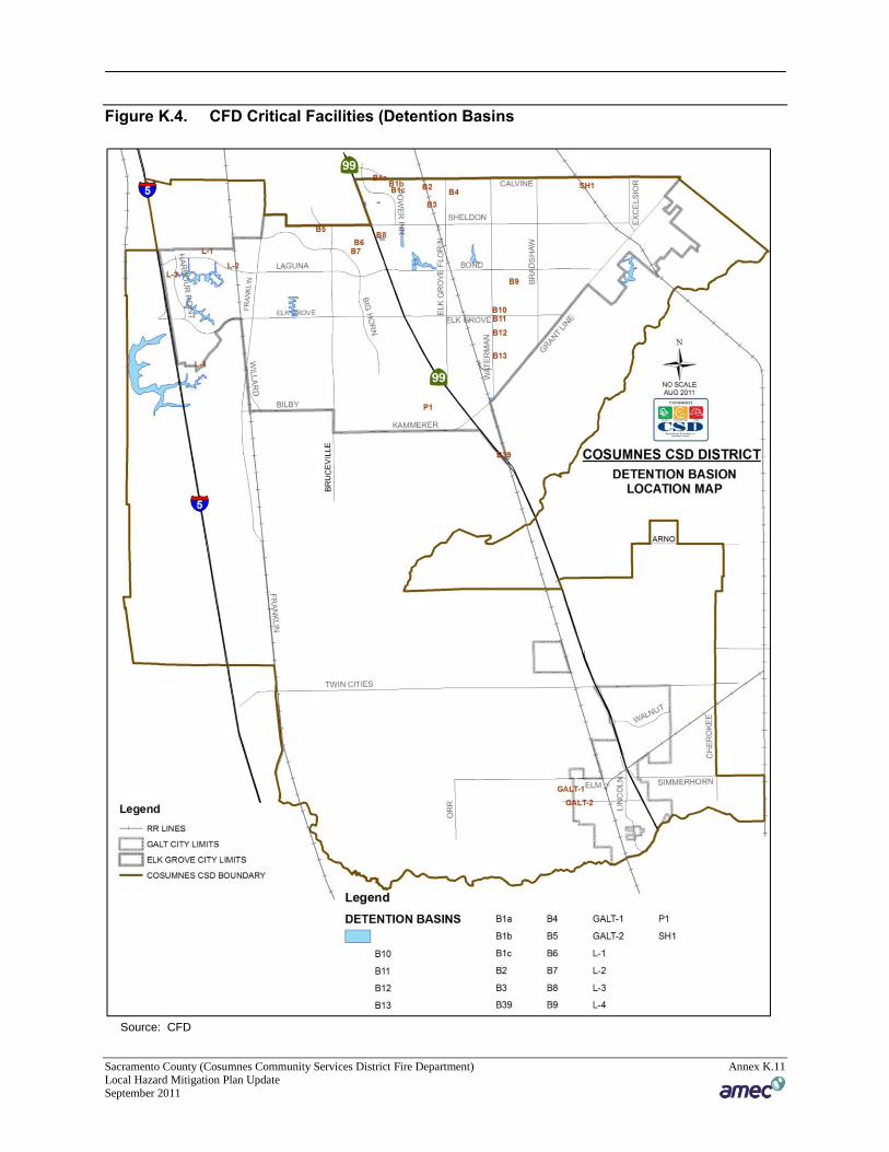
Figure K.4. CFD Critical Facilities (Detention Basins
Source: CFD
Sacramento County (Cosumnes Community Services District Fire Department) Annex K.12 Local Hazard Mitigation Plan Update September 2011
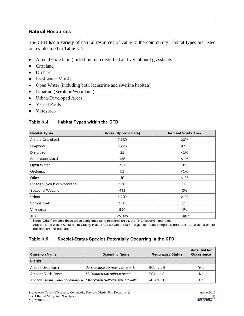
Natural Resources
The CFD has a variety of natural resources of value to the community: habitat types are listed
below, detailed in Table K.5.
Annual Grassland (including both disturbed and vernal pool grasslands)
Cropland
Orchard
Freshwater Marsh
Open Water (including both lacustrine and riverine habitats)
Riparian (Scrub or Woodland)
Urban/Developed Areas
Vernal Pools
Vineyards
Table K.4. Habitat Types within the CFD
Habitat Types Acres (Approximate) Percent Study Area
Annual Grassland 7,550 30%
Cropland 9,276 37%
Disturbed 21 <1%
Freshwater Marsh 135 <1%
Open Water 767 3%
Orchards 51 <1%
Other 10 <1%
Riparian (Scrub or Woodland) 320 1%
Seasonal Wetland 431 2%
Urban 5,232 21%
Vernal Pools 258 1%
Vineyards 954 4%
Total 25,006 100%
Note: “Other” includes those areas designated as recreational areas, the TNC Reserve, and roads.
Source: Draft South Sacramento County Habitat Conservation Plan – vegetation data interpreted from 1997-1998 aerial photos
(minimal ground-truthing)
Table K.5. Special-Status Species Potentially Occurring in the CFD
Common Name Scientific Name Regulatory Status Potential for Occurrence
Plants
Ahart’s Dwarfrush Juncus leiospermus var. ahartii SC; --; 1 B Yes
Amador Rush-Rose Helianthemum suffrutescens SCL; --; 3 No
Antioch Dunes Evening Primrose Oenothera deltoids ssp. Howellii FE; CE; 1 B No
Sacramento County (Cosumnes Community Services District Fire Department) Annex K.13 Local Hazard Mitigation Plan Update September 2011
Common Name Scientific Name Regulatory Status Potential for Occurrence
Boggs Lake Hedge- hyssop Gratiola heterosepala --; CE; 1 B Yes
Delta Tule-pea Lath yrus jepsonii var. jepsonii SC; --; 1 B Yes
Dwarf Downingia Downingia pusilla --; --; 2 Yes
Legenere Legenere limosa SC; --; 1 B Yes
Mason’s Lilaeopsis Lilaeopsis masonii SC; CR; 1 B Yes
Northern California Black Walnut Juglans californica var. hindsii SC; --; 1 B Yes
Pincushion navarettia Naverretia myersii spp. Myersii SC; --; 1 B Yes
Rose Mallow Hibiscus lasiocarpus SC; --; 1 B Yes
Sacramento Orcutt Grass Orcuttia viscida FE; CE; 1 B Yes
Sacramento Orcutt Grass Critical Habitat
Orcuttia viscida Critical Habitat -- Yes
San Joaquin Saltbrush Atriplex joaquiniana SC; --; 1 B Yes
Sanford’s Arrowhead Sagittaria sanfordii SC; --; 1 B Yes
Slender Orcutt Grass Orcuttia tenuis FT; CE; 1 B Yes
Slender Orcutt Grass Critical Habitat
Orcuttia tenuis Critical Habitat -- Yes
Soft Bird’s-Beak Cordylanthus mollis ssp. mollis FE; CR; 1B No
Stinkbells Fritillaria agrestis SCL; --; 4 No
Suisun Marsh Aster Aster lentus SC; --; 1 B No
Tuolomne Coyote-thistle Eryngium pinnatisectum SC; --; 1 B No
Wildlife
Invertebrates
Antioch Dunes anthicid beetle Anthicus antiochensis SC; --; -- No
California linderiella Linderiella occidentalis SC; --; -- Yes
Conservancy fairy shrimp Brachinecta conservation FE; --; -- Yes
Curved-foot hygrotus diving beetle
Hygrotus curvipes SC; --; -- No
Delta Green ground beetle Elaphrus viridis FT; --; -- No
Midvalley Fairy Shrimp Branchinecta mesovallensis SC; --; -- Yes
Sacramento Anthicid beetle Anthicus sacramento SC; --; -- No
San Joaquin Dune beetle Coelus gracilis SC; --; -- No
Valley Elderberry Longhorn beetle
Desmocerus californicus dimorphus FT (PX); --; -- Yes
Vernal Pool Fairy Shrimp Branchinecta lynchi FT; --; -- Yes
Vernal Pool Tadpole Shrimp Lepidurus packardi FE; --; -- Yes
Amphibians/Reptiles
California Horned Lizard Phrynosoma coronatum frontale SC; CSC (protected full species); --
Yes
California Red-legged Frog Rana aurora draytonii FT; CSC (protected full species); --
No
California Tiger Salamander Ambystoma californiense C; CSC (protected); -- Yes
Sacramento County (Cosumnes Community Services District Fire Department) Annex K.14 Local Hazard Mitigation Plan Update September 2011
Common Name Scientific Name Regulatory Status Potential for Occurrence
Giant Garter Snake Thamnophis gigas FT; CT (protected); -- Yes
Foothill Yellow-legged Frog Rana boylii SC; CSC (protected); --
No
Northwestern Pond Turtle Clemmys marmorata marmorata SC; CSC; -- Yes
Silvery Legless Lizard Anniella pulchra pulchra SC; CSC; -- Yes
Western Spadefoot Toad Scaphio pus hammondii SC; CSC (protected); --
Yes
Fish
Central Valley Fall/Late Fall-run Chinook Salmon and Critical Habitat
Oncorhynchus tshawytscha C; CSC; -- Yes
Central Valley Spring-run Chinook Salmon
Oncorhynchus tshawytscha FT; CT; -- Yes
Central Valley Winter – run Chinook Salmon and Critical Habitat
Oncorhynchus tshawytscha FE; CE; -- Yes
Central Valley Steelhead Oncorhynchus mykiss FT; --; -- Yes
Delta Smelt Hypomesus transpacificus FT; CT; -- Yes
Green Sturgeon Acipenser medirostris SC; CSC; -- Yes
Kern Brook Lamprey Lam petra hubbsi SC; CSC; -- No
Longfin Smelt Spirinchus thaleichthys SC; CSC; -- No
Pacific Lamprey Lam petra trident ata SC; --; -- Yes
River Lamprey Lam petra ayresi SC; CSC; -- Yes
Sacramento Perch Arc hoplites interruptus --; CSC; -- No
Sacramento Splittail Pogonichthys macrolepidotus FT; CSC; -- Yes
Birds
Aleutian Canada Goose Branta Canadensis leucopareia FD; --; -- (Wintering) Yes
American Bittern Botaurus lentiginosus SC; --; -- Yes
American Peregrine Falcon Falco peregrinus anatum D; CE (fully protected); -- (nesting)
No
Bald Eagle Haliaeetus leucocephalus FT (PD); CE (fully protected); -- (nesting and wintering)
No
Bank Swallow Riparia riparia --; CT; -- (nesting) Yes
Black Rail Laterallus jamaicensis coturniculus SC; CT (fully protected); --
Yes
Black Tern Chlidonias niger SC; CSC; -- (nesting colony)
Yes
Brewer’s Sparrow Spizella breweri SC; --; -- (nesting) No
California Thrasher Toxostoma redivivum SC; --; -- No
Common Loon Gavia immer SC; CSC; -- (nesting) No
Cooper’s Hawk Accipiter cooperi --; CSC; -- (nesting) Yes
Sacramento County (Cosumnes Community Services District Fire Department) Annex K.15 Local Hazard Mitigation Plan Update September 2011
Common Name Scientific Name Regulatory Status Potential for Occurrence
Double-crested cormorant Phalacrocorax aurit us --; CSC; -- (rookery site)
No
Grasshopper Sparrow Ammodramus savannarum SC; --; -- (nesting) Yes
Great Blue Heron Ardea herodias --; CDF (sensitive); -- (rookery)
Yes
Great Egret Ardea alba --; CDF (sensitive); -- (rookery)
Yes
Greater Sandhill Crane Grus Canadensis tabida --; CT (fully protected); --
Yes
Lawrence’s Goldfinch Carduelis lawrencei SC; --; -- (nesting) No
Lewis’ Woodpecker Melanerpes lewis SC; --; -- (nesting) No
Little Willow Flycatcher Empidonax traillii brewsteri SC; --; -- (nesting) No
Loggerhead Shrike Lanius ludovivianus SC; CSC; -- (nesting) Yes
Long-billed Curlew Numenius americanus SC; CSC; -- (nesting) No
Mountain Plover Charadrius montanus FPT; CSC; -- (wintering)
Yes
Nuttall’s Woodpecker Picoides nuttallii SLC; --; -- Yes
Oak Titmouse Baeolophus inornatus SLC; --; -- Yes
Rufous hummingbird Selasphorus rufus SC (MNBMC); --; -- (nesting)
No
Short-eared Owl Asio flammeus SC; --; -- (nesting) No
Snowy Egret Egretta thula SC; --; -- (rookery) Yes
Swainson’s Hawk Buteo swainsoni --; CT; -- Yes
Tricolored Blackbird Agelaius tricolor SC; CSC; -- (nesting colony)
Yes
Western Burrowing Owl Athene cunicularia hypugea SC; CSC; -- (burrowing sites)
Yes
Western Yellow-billed Cuckoo Coccyzus americanus occidentalis SC; CE (fully protected); -- (nesting)
Yes
White-faced Ibis Plegadis chihi SC; CSC; -- (rookery site)
No
White-tailed Kite Elanus caeruleus SC; (fully protected); - - (nesting)
Yes
Mammals
Fringed Myotis Myotis thysanodes SC; --; -- Yes
Greater Western Mastiff bat Eumops perotis californicus SC; CSC; -- Yes
Long-eared Myotis Myotis evotis SC; --; -- Yes
Long-legged Myotis Myotis volans SC; --; -- Yes
Pacific Western Big- eared bat Corynorhinus townsendii townsendii SC; CSC (full species); --
Yes
Pale Townsend’s Big- eared bat Corynorhinus townsendii pallescens SC; CSC (full species); --
Yes
Sacramento County (Cosumnes Community Services District Fire Department) Annex K.16 Local Hazard Mitigation Plan Update September 2011
Common Name Scientific Name Regulatory Status Potential for Occurrence
San Francisco Dusky- footed woodrat
Neotoma fuscipes annectens SC; CSC; -- No
San Joaquin Pocket Mouse Perognathus inornatus SC; --; -- Yes
San Joaquin Woodrat Neotoma fuscipes riparia FE; CSC; -- No
Small-footed Myotis Myotis ciiolabrum SC; --; -- Yes
Yuma Myotis Myotis yumanensis SC; --; -- Yes
FE = federally endangered FT = federally threatened SC = federal species of concern C = candidate FPT = federal proposed threatened FPE = federal proposed endangered SLC = Species of Local Concern CE = state endangered CT = state threatened CR = state rare CSC = California species of special concern C = candidate for listing 1 B = CNPS list plants rare, threatened, or endangered in California or elsewhere 2 = CNPS list plants rare, threatened, or endangered in California, but more numerous elsewhere * = not enough information available on this species 3 = CNPS list plants about which CNPS needs more information 4 = CNPS list plants of limited distribution – a watch list
Source: Foothill Associates, 2002
Historic and Cultural Resources
The CFD has 4 has registered federal historic sites:
William Ehrhardt House (Elk Grove)
Elk Grove Historic District (Elk Grove)
Brewster Building (Galt)
Brewster House (Galt)
In addition to the registered sites, there are several assets within CFD that define the community
and represent the area's history. Some additional historical sites of importance are listed below.
Old Town Elk Grove Shopping District.
Rhodes School - first constructed in 1872, now located in Elk Grove Park.
Murphy’s Corral site of the beginning of the conquest of California by the United States on
June 10, 1846.
Galt Historic Business District.
Economic Assets
The largest employers with the CFD include: The Elk Grove Unified School District, and Kaiser
Permanente.
Sacramento County (Cosumnes Community Services District Fire Department) Annex K.17 Local Hazard Mitigation Plan Update September 2011
Growth and Development Trends
As of 2010 the growth within the CFD has been at 2.51%.
K.5.2 Priority Hazards: Vulnerability Assessment
This section provides the vulnerability assessment, including any quantifiable loss estimates, for
those hazards identified above in Table K.1 as high or medium significance hazards. Impacts of
past events and vulnerability of the District to specific hazards are further discussed below (see
Section 4.1 Hazard Identification for more detailed information about these hazards and their
impacts on the Sacramento County planning area). Methodologies for calculating loss estimates
are the same as those described in Section 4.3 of the base plan. In general, the most vulnerable
structures are those located within the floodplain or within levee and dam inundation areas,
unreinforced masonry buildings, and buildings built prior to the introduction of modern building
codes.
Agricultural Hazards: Insects/Pests
Agricultural cropland occurs interspersed throughout the rural residential areas in the City of Elk
Grove, and throughout the Planning Area, with the majority occurring within the western portion
of the Planning Area. Because this habitat is intensively managed, vegetation is limited to
cultivate crops, predominately grains, orchards, and vineyards, with ruderal (weedy) vegetation
along the margins. Ruderal species observed include Italian ryegrass (Lolium multiforum), ripgut
brome (Bromus diandrus), and yellow star-thistle (Centaurea solstitialis).
Drought
Drought is different than many of the other natural hazards in that it is not a distinct event and
usually has a slow onset. Drought can severely impact a region both physically and
economically. Drought affects different sectors in different ways and with varying intensities.
Adequate water is the most critical issue and is critical for manufacturing, tourism, recreation,
and commercial and domestic use. As the population in the area continues to grow, so will the
demand for water.
Based on historical information, the occurrence of drought in California, including the Cities of
Elk Grove and Galt, is cyclical, driven by weather patterns. Drought has occurred in the past and
will occur in the future. Periods of actual drought with adverse impacts can vary in duration, and
the period between droughts is often extended. Although an area may be under an extended dry
period, determining when it becomes a drought is based on impacts to individual water users.
The vulnerability of Elk Grove and Galt to drought is City-wide, but impacts may vary and
include reduction in water supply and an increase in dry fuels.
Sacramento County (Cosumnes Community Services District Fire Department) Annex K.18 Local Hazard Mitigation Plan Update September 2011
Flood
Flood (Elk Grove)
Elk Grove area is part of the Sacramento River watershed, which covers approximately 27,000
square miles, with 400 miles of river from Lake Shasta to the convergence of the Sacramento-
San Joaquin Delta. The City is also a part of this larger watershed. More specifically, surface
water resources in Elk Grove are a part of the Morrison Creek Stream Group, and include Elder,
Elk Grove, Laguna (and tributaries), Morrison, Strawberry, and Whitehouse Creeks. Florin,
Gerber, and Union House creeks are located close to the City. Deer Creek is located in the
eastern portion of the City, parallel to the Cosumnes River. The Cosumnes River is the eastern
border of the City; however, all of the creeks in the area drain into the Morrison Creek Stream
Group, then eventually into the Sacramento River. Runoff from precipitation and snowmelt
from the Sierra Nevada mountains are the main sources of surface water supply in the City.
Laguna Creek, the Cosumnes River, and the Sacramento River are the main surface hydrological
features in the City. The Morrison Creek Stream Group drainage basin covers 192 square miles.
The nine creeks that drain into Morrison Creek flow southwest and eventually drain into the
Beach Stone Lakes area west of Interstate 5.
Laguna Creek, the main creek that flows through the City of Elk Grove, has been altered by
development. There have been channels, levees, and culverts created to alleviate the possibility
of flooding, as well as to accommodate different development scenarios. Some of the other
creeks in the City have also been altered to accommodate development or alleviate flooding
potential. Structures and assets at risk, population at risk, and critical facilities at risk for Elk
Grove can be found in their annex (Annex B) to this plan.
Flood (Galt)
Although the City is located outside of the major flood plain area, the City experiences two types
of flooding. The first is associated with local water courses. The second is associated with
localized flood events resulting from inadequate surface flow. Heavy rainfall causes these types
of flooding events.
Runoff from the City’s study area is drained by a variety of local streams and creeks including
Badger Creek, Willow Creek, Laguna Creek, Skunk Creek, Deadman Gulch, and Dry Creek,
which drain to the Cosumnes River. The areas near the confluence of these smaller water
courses with the Cosumnes River includes large areas of flood plain, which absorb excess flows
from local watersheds during heavy rains and spring floods. Much of the storm water of this
floodplain is maintained through a complex system of levees and dikes. Structures and assets at
risk, population at risk, and critical facilities at risk for Galt can be found in their annex (Annex
D) to this plan.
Sacramento County (Cosumnes Community Services District Fire Department) Annex K.19 Local Hazard Mitigation Plan Update September 2011
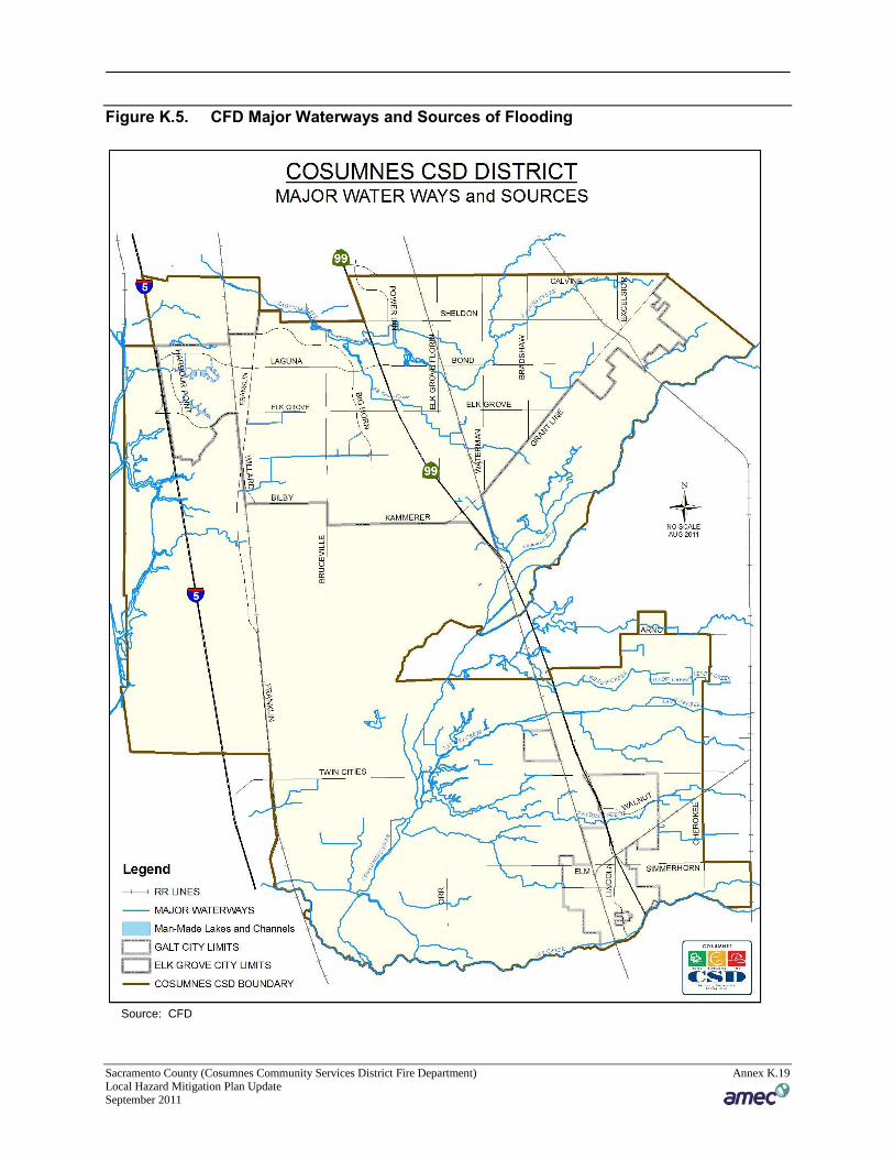
Figure K.5. CFD Major Waterways and Sources of Flooding
Source: CFD
Sacramento County (Cosumnes Community Services District Fire Department) Annex K.20 Local Hazard Mitigation Plan Update September 2011
The CFD experienced a significant flood specifically in January 1997. During this time period
major transportation corridors, Interstate 5 and Highway 99 were shut down due to rising water
levels. The loss of transportation corridors had a major impact on emergency services delivery
to quickly respond to routine and flood related emergencies. The rising waters from the
Cosumnes River essentially divided the district into two separate areas
Flood: Localized/Stormwater
Elk Grove
Historically, the City of Elk Grove has been at risk to flooding primarily during the spring
months when river systems in the County swell with heavy rainfall. Localized flooding also
occurs at various times throughout the year with several areas of primary concern unique to the
City of Elk Grove. In the “Sheldon” area of Elk Grove, local flooding is widespread but
generally minor; the flat land causes floodwaters to spread out, reducing threats to life. These
areas of concern are shown in Annex B: City of Elk Grove of this plan.
Galt
Flooding events can occur any time during the rainy season (November to April). These events
result from prolonged, heavy rainfall and are characterized by high peak flows of moderate
duration and large volumes of runoff. Flooding is more severe when prior rainfall has resulted in
saturated ground conditions. Other localized flooding hazards are caused by obstacles to natural
drainage flows, such as small creek dams and dikes formed by freeway and railroad fills.
Cloudburst storms, sometimes lasting as long as three hours, can occur any time from the late fall
to early spring, and may occur as an extremely severe sequence within a general winter
rainstorm. Flooding from cloudburst activity is characterized by high peak flow, short duration
of flood flow, and a small volume of runoff.
Potential issues of concern include a general lack of curbs and gutters in portions of the City of
Galt. The lack of curb and gutters along with inadequate or incomplete storm drains can result in
standing water that is both a public health nuisance and a potential hazard. Other sources of
flooding concern are the size and capacity of small agricultural drainage structures that do not
accommodate large storm flows.
More information on localized flooding in the City of Galt can be found in Annex D: City of
Galt of this plan.
Severe Weather: Extreme Heat
The Cosumnes Fire Department experiences temperatures in excess of 100 degrees during the
summer and fall months. The temperature moves to 105-110°F in rather extreme situations (see
chart below). Many months see a high number of days where daily high temperatures exceed
90°F. Generally, people who live and work in this weather are prepared to cope with the
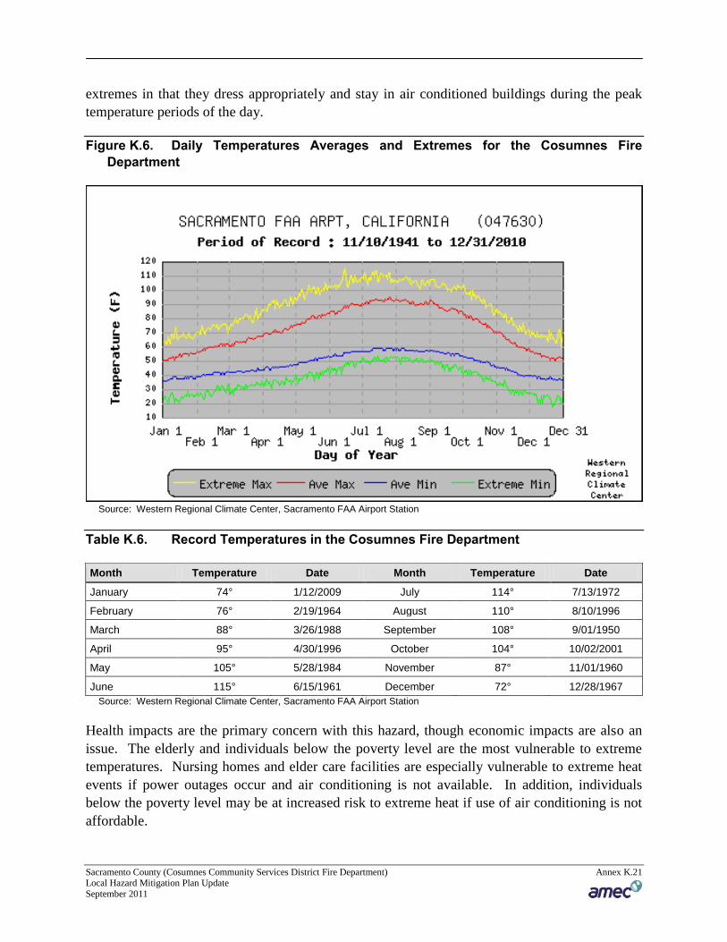
Sacramento County (Cosumnes Community Services District Fire Department) Annex K.21 Local Hazard Mitigation Plan Update September 2011
extremes in that they dress appropriately and stay in air conditioned buildings during the peak
temperature periods of the day.
Figure K.6. Daily Temperatures Averages and Extremes for the Cosumnes Fire
Department
Source: Western Regional Climate Center, Sacramento FAA Airport Station
Table K.6. Record Temperatures in the Cosumnes Fire Department
Month Temperature Date Month Temperature Date
January 74° 1/12/2009 July 114° 7/13/1972
February 76° 2/19/1964 August 110° 8/10/1996
March 88° 3/26/1988 September 108° 9/01/1950
April 95° 4/30/1996 October 104° 10/02/2001
May 105° 5/28/1984 November 87° 11/01/1960
June 115° 6/15/1961 December 72° 12/28/1967
Source: Western Regional Climate Center, Sacramento FAA Airport Station
Health impacts are the primary concern with this hazard, though economic impacts are also an
issue. The elderly and individuals below the poverty level are the most vulnerable to extreme
temperatures. Nursing homes and elder care facilities are especially vulnerable to extreme heat
events if power outages occur and air conditioning is not available. In addition, individuals
below the poverty level may be at increased risk to extreme heat if use of air conditioning is not
affordable.
Sacramento County (Cosumnes Community Services District Fire Department) Annex K.22 Local Hazard Mitigation Plan Update September 2011
Reliance on air conditioning can cause a strain on the electrical energy in the Cosumnes Fire
Department operational area. Occasionally peak demands outweigh supply and a condition
known as brown-out occurs. This is an extremely dangerous situation for electrical equipment as
it operates without the needed electricity causing damage to the systems. Days of extreme heat
have been known to result in medical emergencies, civil unrest, and unpredictable human
behavior. Periods of extended heat and dryness (droughts) can have major economic,
agricultural, and water resources impacts.
Severe Weather: Fog
The Sacramento Valley can produce some extremely dangerous fog in the winter and early
spring months. These are a type of radiation fog called “tule fog.” Tule Fog forms on cold and
clear nights, when the ground is moist and there is very little wind. Under such conditions the
ground cools quickly and thus cools the air above it as well. The moisture in this cooled air
condenses and can create extremely dense fog. Since the air may be stagnant and there is little
evaporative effect from the sun in winter months, tule fogs can last for several days and, in some
instances, over a week. Under these conditions, visibility is often reduced to 600 feet, but can
drop to less than 10 feet.
When tule fog forms, a severe risk is posed to traffic with the potential for multi-car pileups,
especially on freeways such as Highway 99 and Interstate 5. This may have an economic impact
on the communities of Elk Grove, and Galt due to delays in transportation times or even the
shutting-down of the major freeways of Interstate 5 and Highway 99. The same dense and
lingering fog can also produce adverse health effects in the population with respiratory ailments.
The Sacramento Air Quality Management District on occasion will impose burning restrictions
on county residents to minimize the poor air quality as a result of the fog which traps the smoke
at ground level and prevents the smoke from rising during tule fog events.
Severe Weather: Heavy Rain and Storms
According to historical hazard data, severe weather is an annual occurrence in the communities
served by the Cosumnes Fire Department. Damage and disaster declarations related to severe
weather have occurred and will continue to occur in the future. Heavy rains and thunderstorms
are the most frequent type of severe weather occurrence in the area. Wind and lightning often
accompany these storms and have caused damage. Problems associated with the primary effects
of severe weather include flooding, pavement deterioration, washouts, high water crossings,
landslide/mudslides, debris flows, and downed trees and power outages.
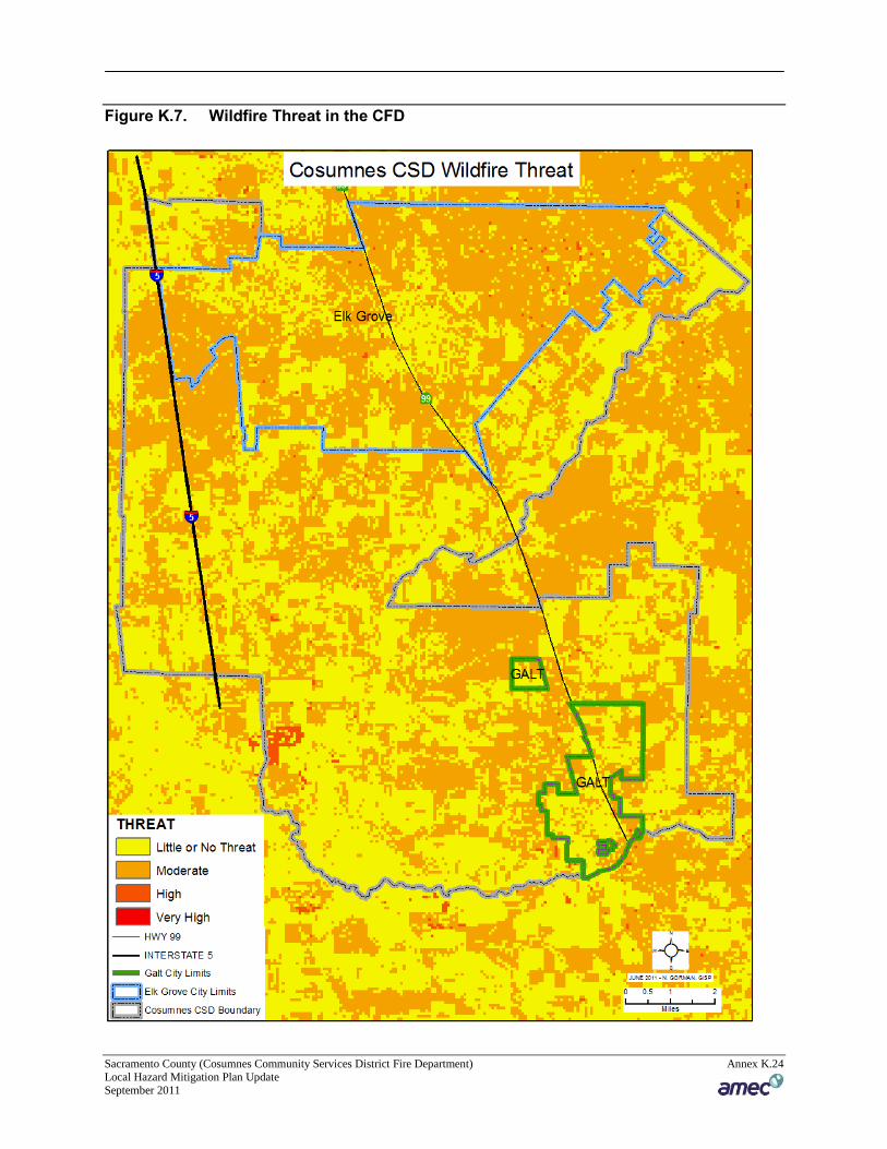
Wildfire
Wildland fires are common in open space areas with vegetation that exhibits low fuel moisture.
The threat for wildland fires is increased during the warmer months which are typically from late
May until late October of every year. High winds can also contribute to the spread and severity
of the fire. Specifically winds from the north which is drying winds they will support extreme
Sacramento County (Cosumnes Community Services District Fire Department) Annex K.23 Local Hazard Mitigation Plan Update September 2011
wildland fire behavior, as opposed to winds from the west which have the ability to add moisture
to fuels minimizing extreme fire behavior. Generally, the undeveloped portions of the Cosumnes
Fire Department do not pose a high risk due to existing agricultural practices on the land. Most
lands are actively cultivated with irrigated crops that have minimal fire fuel. However, grass
fires can occur on uncultivated lands, particularly where there is native vegetation, such as the
riparian corridors near local water courses. Fire hazards also exist in urbanized areas of the
Cosumnes Fire Department. Residential and Commercial structure fires can occur particularly in
neighborhoods where you have a mix of undeveloped parcels adjacent to developed parcels
which requires a higher level of emergency resources for suppression activities. Additionally, in
the rural setting the use of propane gas is commonly used for heating and cooking by residents.
The propane is stored in large tanks ranging in size from 300 gallons up to 1,000 gallons and will
create additional safety concerns for responding fire personnel in the wildland urban interface
environment. Figure K.7 depicts the wildfire threat in the Cosumnes Fire Department.
Sacramento County (Cosumnes Community Services District Fire Department) Annex K.24 Local Hazard Mitigation Plan Update September 2011
Figure K.7. Wildfire Threat in the CFD
Sacramento County (Cosumnes Community Services District Fire Department) Annex K.25 Local Hazard Mitigation Plan Update September 2011
K.6 Capability Assessment
Capabilities are the programs and policies currently in use to reduce hazard impacts or that could
be used to implement hazard mitigation activities. This capability assessment is divided into
three sections: regulatory mitigation capabilities, administrative and technical mitigation
capabilities, and fiscal mitigation capabilities.
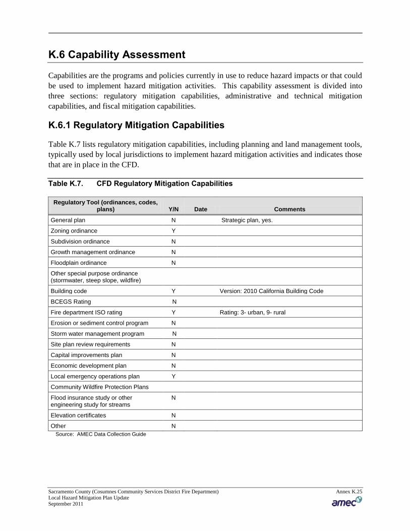
K.6.1 Regulatory Mitigation Capabilities
Table K.7 lists regulatory mitigation capabilities, including planning and land management tools,
typically used by local jurisdictions to implement hazard mitigation activities and indicates those
that are in place in the CFD.
Table K.7. CFD Regulatory Mitigation Capabilities
Regulatory Tool (ordinances, codes, plans) Y/N Date Comments
General plan N Strategic plan, yes.
Zoning ordinance Y
Subdivision ordinance N
Growth management ordinance N
Floodplain ordinance N
Other special purpose ordinance (stormwater, steep slope, wildfire)
Building code Y Version: 2010 California Building Code
BCEGS Rating N
Fire department ISO rating Y Rating: 3- urban, 9- rural
Erosion or sediment control program N
Storm water management program N
Site plan review requirements N
Capital improvements plan N
Economic development plan N
Local emergency operations plan Y
Community Wildfire Protection Plans
Flood insurance study or other engineering study for streams
N
Elevation certificates N
Other N
Source: AMEC Data Collection Guide
Sacramento County (Cosumnes Community Services District Fire Department) Annex K.26 Local Hazard Mitigation Plan Update September 2011
K.6.2 Administrative/Technical Mitigation Capabilities
Table K.8 identifies the Districts department(s) responsible for activities related to mitigation
and loss prevention in CFD.
Table K.8. CFD Administrative and Technical Mitigation Capabilities
Personnel Resources Yes/No Department/Position Comments
Planner/Engineer with knowledge of land development/land management practices
N
Engineer/Professional trained in construction practices related to buildings and/or infrastructure
N
Planner/Engineer/Scientist with an understanding of natural hazards
N
Personnel skilled in GIS Y GIS Coordinator
Full time building official N
Floodplain Manager N
Emergency Manager Y Administrative Battalion Chief
Grant writer N Various individuals within the CSD
Other personnel N
GIS Data – Hazard areas N GIS Coordinator
GIS Data - Critical facilities N GIS Coordinator
GIS Data – Building footprints N GIS Coordinator
GIS Data – Land use N
GIS Data – Links to Assessor’s data Y GIS Coordinator
Warning Systems/Services (Reverse 9-11, cable override, outdoor warning signals)
N
Other N
Source: AMEC Data Collection Guide
K.6.3 Fiscal Mitigation Capabilities
Table K.9 identifies financial tools or resources that the District could potentially use to help
fund mitigation activities.
Table K.9. CFD Fiscal Mitigation Capabilities
Financial Resources Accessible/Eligible to Use (Y/N) Comments
Community Development Block Grants
Y
Capital improvements project funding N
Authority to levy taxes for specific purposes
N
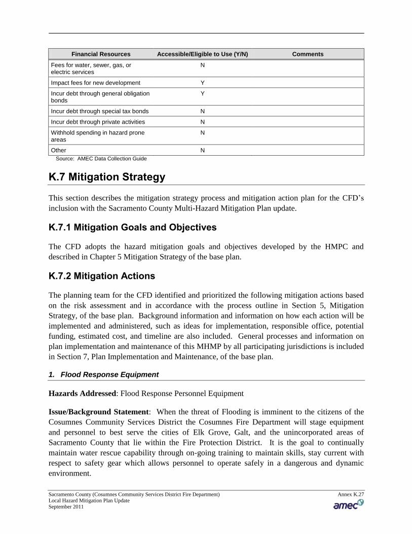
Sacramento County (Cosumnes Community Services District Fire Department) Annex K.27 Local Hazard Mitigation Plan Update September 2011
Financial Resources Accessible/Eligible to Use (Y/N) Comments
Fees for water, sewer, gas, or electric services
N
Impact fees for new development Y
Incur debt through general obligation bonds
Y
Incur debt through special tax bonds N
Incur debt through private activities N
Withhold spending in hazard prone areas
N
Other N
Source: AMEC Data Collection Guide
K.7 Mitigation Strategy
This section describes the mitigation strategy process and mitigation action plan for the CFD’s
inclusion with the Sacramento County Multi-Hazard Mitigation Plan update.
K.7.1 Mitigation Goals and Objectives
The CFD adopts the hazard mitigation goals and objectives developed by the HMPC and
described in Chapter 5 Mitigation Strategy of the base plan.
K.7.2 Mitigation Actions
The planning team for the CFD identified and prioritized the following mitigation actions based
on the risk assessment and in accordance with the process outline in Section 5, Mitigation
Strategy, of the base plan. Background information and information on how each action will be
implemented and administered, such as ideas for implementation, responsible office, potential
funding, estimated cost, and timeline are also included. General processes and information on
plan implementation and maintenance of this MHMP by all participating jurisdictions is included
in Section 7, Plan Implementation and Maintenance, of the base plan.
1. Flood Response Equipment
Hazards Addressed: Flood Response Personnel Equipment
Issue/Background Statement: When the threat of Flooding is imminent to the citizens of the
Cosumnes Community Services District the Cosumnes Fire Department will stage equipment
and personnel to best serve the cities of Elk Grove, Galt, and the unincorporated areas of
Sacramento County that lie within the Fire Protection District. It is the goal to continually
maintain water rescue capability through on-going training to maintain skills, stay current with
respect to safety gear which allows personnel to operate safely in a dangerous and dynamic
environment.
Sacramento County (Cosumnes Community Services District Fire Department) Annex K.28 Local Hazard Mitigation Plan Update September 2011
Other Alternatives: One alternative is to develop automatic aid agreements with neighboring
jurisdictions both police and fire to share resources. These agreements complement each other
when flooding is more localized. If flooding is widespread, throughout the region, then the
ability to count on neighboring jurisdictions is diminished because resources are deployed to
respond to emergencies within their response areas reducing the amount of available resources.
Another alternative is to deploy and staff the departments flood boats adding an increased flood
response capability to the response area.
Existing Planning Mechanisms through which Action will be implemented: Personnel will
continually review flood boat operations, conduct assessments of safety gear to ensure that all of
the dry and wet suits are safe for emergency responders and that the suits provide a barrier from
contaminated water. Perform site evaluations of flood prone areas, and continue to work with
neighboring emergency responders to strengthen working relationships in the area of emergency
response.
Responsible Office: Deputy Chief of Operations
Priority: High
Cost Estimate: To purchase water rescue safety gear for 20 emergency responders is $20,000.
The water rescue safety gear is a combination of gear which includes:
a personal floatation device(lifejacket)
a whistle used to communicate during water rescue operations,
a dry suit to be used during sustained rescue operations
a helmet
All Terrain Booties
Swimfins
Gloves
Knife
Rope bag with a minimum of 75' of Polypropylene rope. Polypropylene rope is designed
float and is water resistant
The cost is approximately $1,000 for a complete set per employee.
Benefits (Losses Avoided):
Immediate response to life threaten emergencies
Better response capabilities through the use of flood rescue boats, and properly trained and
equipped fire personnel.
Greater operating capability, with proper equipment.
Potential Funding:
Sacramento County (Cosumnes Community Services District Fire Department) Annex K.29 Local Hazard Mitigation Plan Update September 2011
Grant opportunities to purchase personnel safety equipment to properly staff the 8 flood
rescue boats and 2 swiftwater rescue boats.
Donations from private parties, looking to support emergency operations
General fund request from the CFD budget process
Schedule: Proper safety gear will allow personnel to continually perform site evaluations of
high risk flood prone areas. Furthermore, meet and train with neighboring emergency service
providers to review their response capability, and any additional changes in their operations from
the previous year.
2. Flood Response Training
Hazards addressed: Flood Response Personnel Training
Issue/Background Statement: Flood rescue operations are very unpredictable and inherently
dangerous to all emergency personnel who operate in this environment. The skill sets required to
operate safely and effectively take time to acquire and demonstrate proficiency. The flood
rescue environment also contains many unknowns as it pertains to water quality, and underwater
hazards that can impact rescue operations by trained personnel. Continual investment in fire
personnel training will minimize the risk to the public and fire personnel as they operate in an
unpredictable flood environment.
Existing Planning Mechanisms through which Action will be implemented: Working
through the Cosumnes Fire Department Training Division, personnel will continually review
flood boat operations, conduct assessments of safety gear to ensure that all of the dry and wet
suits are safe for emergency responders and that the suits provide a barrier from contaminated
water. Perform site evaluations of flood prone areas, and continue to work with neighboring
emergency responders to strengthen working relationships in the area of emergency response.
Responsible Office: Deputy Chief of Operations and the Battalion Chief of Training for the
Cosumnes Fire Department.
Priority: High
Cost Estimate: These course descriptions and costs were provided by Rescue 3 International. It
would be the intent to provide these courses every other year as part of ongoing skills
maintenance for all fire line personnel.
Swiftwater Rescue Technician: The SRT1 course provides fire personnel with the fundamentals
of survival in moving water and training to affect in-water rescues. Fire personnel gain
knowledge in hydrology and river classifications, size-up, and site control and scene
management. Practical skills include self-rescue, swiftwater swimming and the fundamentals of
shore, boat and in-water rescues. Additionally fire personnel are introduced to the basics of boat
Sacramento County (Cosumnes Community Services District Fire Department) Annex K.30 Local Hazard Mitigation Plan Update September 2011
handling and the fundamentals of rope rescue including mechanical advantage and anchor
systems.
Swiftwater Rescue Technician Advanced: will challenge fire personnel beyond the emphasis on
self-rescue to concentrate on victim rescue. Fire personnel are exposed to more complex water
rescue situations including a mock night river rescue scenario. The three day course includes 4-6
hours of classroom instruction, followed by two and one-half days of hands-on skill
development.
Fire personnel are introduced to the role and utilization of various skills in river and flood rescue,
including:
rope systems
management of litter & patient raising systems
highline systems
advanced river search concepts
performing rescues at night or in low visibility
Basic flood disaster management.
Flood Rescue Boat Operator: this course is designed to train fire personnel in handling
motorized boats during flood operations. Fire personnel are exposed to a number of topics
including types of motorized boats suitable for water rescue, boat handling on still or slowly
moving water, crew roles, boat safety and problem solving. Techniques are then put to work
doing searches in flood environments, stranded victim and in-water retrieval, and rescue of
conscious and unconscious persons
Swiftwater Rescue Boat Operator: this course is designed to introduce fire personnel to boat
operations on swiftwater. During the course fire personnel gain experience reading moving
water and operating boats in current. Using a motor and paddles, fire personnel will practice
such skills as use and avoidance of hydraulics, ferrying across current, and obstacle navigation
will be practiced in class I and II whitewater. Fire personnel then progress to operating both up
and down stream in class III and above whitewater. Other exercises include night operation
scenarios and multiple boat operations.
The total dollar amount to deliver this level of training to 140 line employees every other year is
approximately $122,000 or $61, 000 annually.
$48,800 is allocated for boat operator training for approximately 50 personnel.
$36,600 is allocated for Swiftwater Rescue Technician Unit 1 for 140 personnel.
$36,600 is allocated for Swiftwater Rescue Technician Advanced for 140 personnel.
Sacramento County (Cosumnes Community Services District Fire Department) Annex K.31 Local Hazard Mitigation Plan Update September 2011
Benefits (Losses Avoided): The benefit to completing this training is that the Cosumnes Fire
Department is able to field a trained and capable water rescue team to affect rescues for the
citizens and members of the public who are in need of emergency assistance.
Potential Funding:
Grant opportunities to fund training for fire personnel to properly staff the 8 flood rescue
boats and 2 swiftwater rescue boats.
Donations from private parties, looking to support training programs
General fund request from the CFD budget process
Schedule: On a bi-annual basis the Cosumnes Fire Department will instruct all personnel on
swiftwater survival skills. The Department will also deliver a focused review on boat operations
with personnel assigned to 2 of the fire stations that specialize in water rescue emergencies. The
training will allow personnel to safely perform site evaluations of high risk flood prone areas.
Furthermore, meet and train with neighboring emergency service providers to review their
response capability and any additional changes in their operations from the previous year.