Embed Size (px)
Citation preview

Annex 2 to Chapter 2 page 1
Annex 2.2 Database on tailings

Annex 2 to Chapter 2 page 2
Tailing No.: 3 Type: (pouring, tier); Mill tailings Location: 72° 28`34`` E 41° 16`56`` N Altitude (above sea level): 983 to 1020 m (Jala Abad Oblast) left river bank of Mailuu Suu River, opposite of Isolit factory Sediments type: Uranium ore processing residues (mill-tailings); valley fill;+-organised
Type of dam: hydraulic fill with support dam ; pioneer dam 70 m from M.S. River shoreline and 5 m above water level in river , terraced slopes gravel cover (80 cm) Tailing geometry : length 200m ; width on top 120 m Tailings surface was 20 m above pioneer dam in 1965
Dam geometry: pioneer dam
Surface area: (2 ha ) 24000 (m2) Surface area Length 40 m, width on ridge 3 m,
(m2)
Base area Width at base 40 m
(m2) Base area (m2)
Thickness 34 (m) Thickness Max. height 9 m (m) Volume 110 500 (m3) Capacity (Volume) 33500 (m3) Cover: Vegetation: Material type : gravel and natural accumulation Type: grass (some trees) Thickness : gravel on embankment slope :
0,5 0,8 m (m) Density: not very dense
Surface area (m2) Maturity: not mature due to constant sediment accumul. Water deviation: none Drainage systems: surface water spillway : concrete drainage channels: 0,9 m X 1,5 m (0,8 x 1,0 m ) calculated for 3,6 m³ /s max. waterflow History : (see text in Chapter 3.2.1.1) Operation period : March 1954 to Febr. 1958 deposition of 150 000 m³ of tailings Conservation: 1965 reduction of tailgs. vol. to 110 000 cbm in order to increase the stability
Reclamation: 1960 – 62 ; 1965 – 67 ; mudflow protective dam emplaced in 1995 Cover emplacement Free water noneWater treatment none; Landslide damage yes Dam failures none Previous landslide risks yes Current landslide risks: yes as perceived by the beneficiary risk of the Tektonic landslide Maximum exposure: 2200 (µR/h) Spec. Alpha activity: 350 –28400 (average for M.S.
ores: 1100 –27300). For E-European ores max.: 52600
(Bq/kg)
Main contaminants: Radionuclides Basic risk features: with damage of tailings impoundment , possible release of residues into Mailuu Suu river Risk level: 1 (seismicity in Mailuu Suu region: 9 points “ballovs” equivalent to M>7,5 Richter scale ) Present land use: pasture unfenced Use of materials: Other : M.S. river water used for irrigation in agriculture downstream Possible access : Easy access for people and livestock. Original barbed wire protection buried under sediments Proximity to habitation: 100 m ; 1 km upstream from town limit Mailuu Suu (25000 inhabitants) Remarks (Main pecularities): directly above frequented road between M.S. and Sary Bee below steep cliff face Structure: (section )
Annex 2 to Chapter 2 page 3
Annex 2 to Chapter 2 page 4
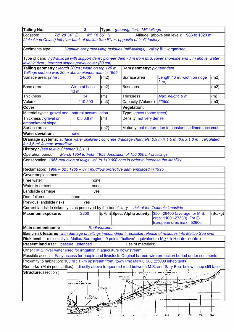
Mailuu Suu waste deposits characterisation data--
Data on contamination: Sediments: Pb (mg/l) Substratum: Pb U 0,01-0,08 % (mg/l) Cd U (mg/l) Cd Ra 2,4 x 10E-7 % As Ra As other other other other
Seepage water: Pb Interstitial water: Pb U (mg/l) Cd U (mg/l) Cd Ra As Ra As other other other other pH: pH:
Groundwater level: Seepage water level in the main body of the tailings pile is 8 – 9 m deep and 1,5 – 2m deep in the pioneer dam area. Seasonal fluctuations 0,5 – 1,5 m. Porosity: 33,7+7,4% Permeabilty: Kf = 0,03 - 0,86 m/d Dry bulk density: Average 1600 kg /cm³ (8)
Particle size distribution : thinly crushed sandy loams (d=0,05 – 0,15 mm ) Actual condition in part still pasty and fluid slimes. The slime part of the tailings amounts to 60 – 80 % of the pulp
Saturation degree above groundwater level : In part fully saturated ; moisture content 15+5,5%
Other physico-chemical (radiological) characteristics : See Chapter 2.10 Dry volumetric weight of the solid part of the tailings : 1,77 x 10E8 kg General (total) activity of radionuclides : 1,8 x 10E14 Bq (including an alpha activity of 9,29 x 10E13 Bq) Geotechnical- Geostability data : Dam stability coefficient Ку=1, is near critical. Stability calculation of MIBI in 1965 : K = 0,945 was not according to the required norms at that time ( k > 1,5)
Mineralogy: Geological setting: Alluvial fill and terraces of the M. S. River valley – 12 to 30 m thick. Terrace sediments : sandy clays with sand – gravel interbeds (8-10 m thick). Substratum of Tp. 3 : weathered sandstones covered by loam and rock debris - talus from slopes above (0,2 m – 1m thick)
Morphology: Slope of depository surface : Average slope of hydraulically deposited materials is 1 : 4 ; (28,5 % slope on western embankment; 8-10 % slope to mudflow protective dam) Slope angles above depository : Steep cliff with outcropping Cretacious sediments adjoining to the E ( 1230 to 1320 m asl.) Slope angles of dam: Hydrogeological data:
Hydrological data: Catchment (Adsorption) area: 24000 (m2) Gamma Survey : 250 µR/hour ; max 550 –2200 µR/hour
Rn emanation : more than 50 Bq /m³ ; prevailing wind direction NE (0,9 – 3 m/s) Actual observations:(Status of dams, impoundment and drainage system) Surface erosion :.Significant, gullies. Depositions : Very Strong depositions from slope and hillside denudation . Old fence (550 m long) is mostly buried under sediment accumulation. Water content in tailings has not decreased significantly since end of operation in 1958 . Seepage water levels even increased between Oct. 1962 and Oct. 63 (8). Expected consolidation of tailings did not take place. The tailings mass is still highly saturated, replenished by influx of underground- and surface waters from the adjacent slope to the E. Damages : erosion of protective layer
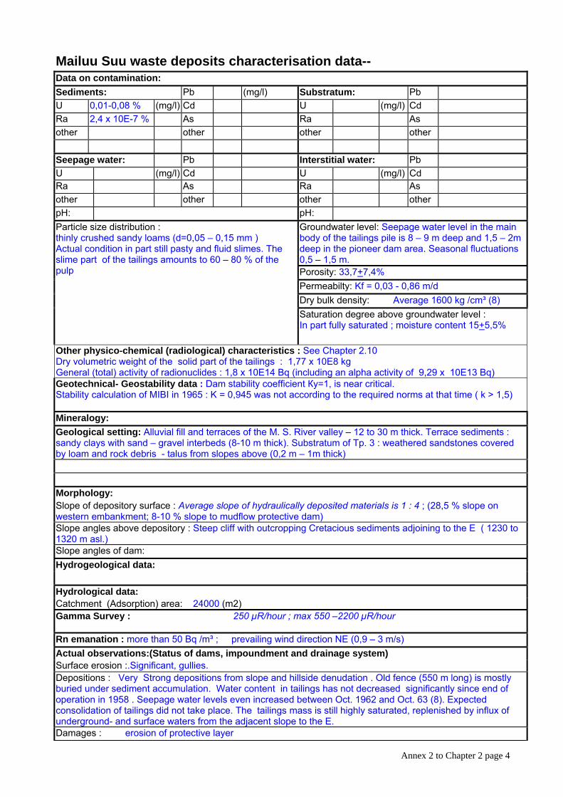
Map:
Photo : View from the E : Tp. 3, 18 (underneath road and Bus stop) and Tp. 9 to the right. “Isolit plant” on right river bank of the M.S. River
Sources and Documentation : MEES and Geopribor (8); GRP “Kiziltepageologia” 1995 (9) Archives:
-The Archives of “Western Mining and Ore processing Plant” contain more detailed information about structure and material properties of the tailings body.
-The Archives of the “Mountain Party of All-Union Hydrogeological Trust” of 1961 Insight in these Archives was not available to the Consortium.
Annex 2 to Chapter 2 page 5
Annex 2 to Chapter 2 page 6
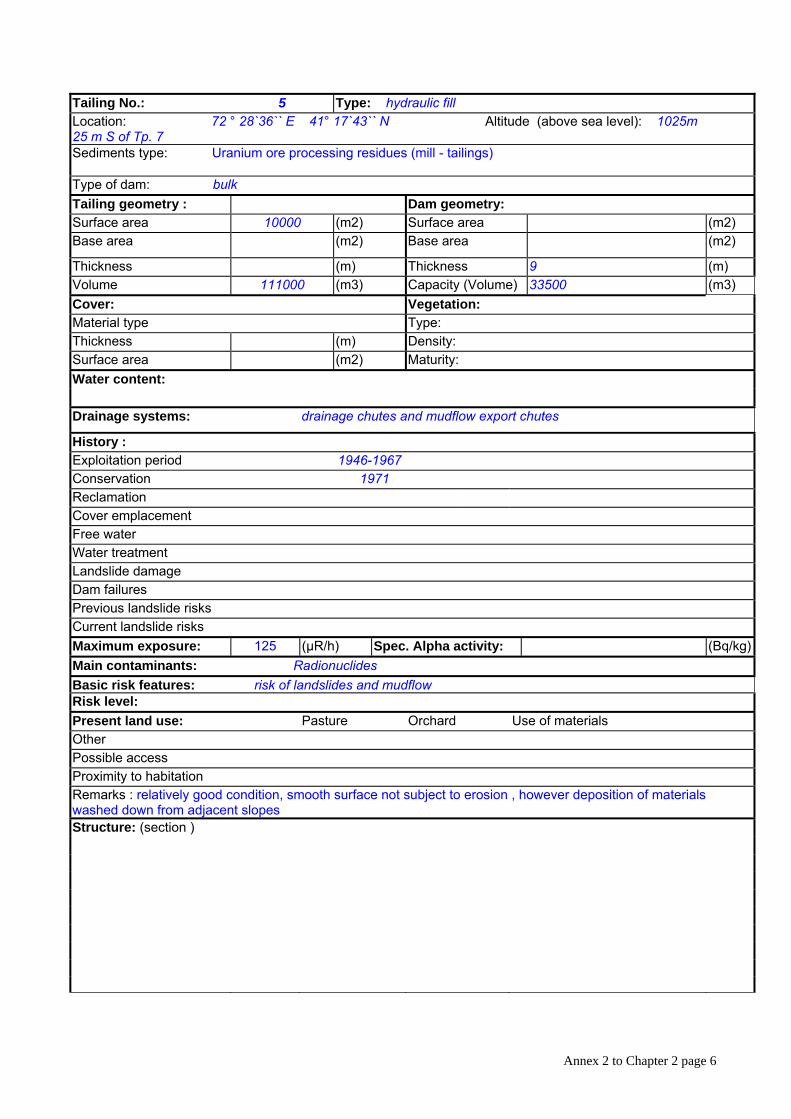
Tailing No.: 5 Type: hydraulic fill Location: 72 ° 28`36`` E 41° 17`43`` N Altitude (above sea level): 1025m 25 m S of Tp. 7 Sediments type: Uranium ore processing residues (mill - tailings)
Type of dam: bulk Tailing geometry : Dam geometry: Surface area 10000 (m2) Surface area (m2) Base area (m2) Base area (m2)
Thickness (m) Thickness 9 (m) Volume 111000 (m3) Capacity (Volume) 33500 (m3) Cover: Vegetation: Material type Type: Thickness (m) Density: Surface area (m2) Maturity: Water content:
Drainage systems: drainage chutes and mudflow export chutes
History : Exploitation period 1946-1967 Conservation 1971 Reclamation Cover emplacement Free water Water treatment Landslide damage Dam failures Previous landslide risks Current landslide risks Maximum exposure: 125 (µR/h) Spec. Alpha activity: (Bq/kg)Main contaminants: Radionuclides Basic risk features: risk of landslides and mudflow Risk level: Present land use: Pasture Orchard Use of materials Other Possible access Proximity to habitation Remarks : relatively good condition, smooth surface not subject to erosion , however deposition of materials washed down from adjacent slopes Structure: (section )
Annex 2 to Chapter 2 page 7
Mailuu Suu waste deposits characterisation -- data
Data on contamination: Sediments: Pb (mg/l) Substratum: Pb U (mg/l) Cd U (mg/l) Cd Ra As Ra As other other other other
Seepage water: Pb Interstitial water: Pb U (mg/l) Cd U (mg/l) Cd Ra As Ra As other other other other pH: pH: Particle size distribution : Groundwater
level:
Porosity: Permeabilty: Dry bulk density: Saturation degree above groundwater level :
Other physico-chemical characteristics :
Geotechnical- Geostability data :
Mineralogy: Geological setting:
Morphology: Slope of depository surface : Slope angles above depository : Slope angles of dam: Hydrogeological data:
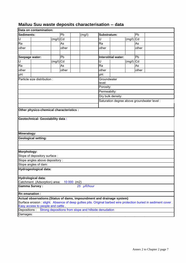
Hydrological data: Catchment (Adsorption) area: 10 000 (m2) Gamma Survey : 25 µR/hour
Rn emanation : Actual observations:(Status of dams, impoundment and drainage system) Surface erosion : slight. Absence of deep gullies pits. Original barbed wire protection buried in sediment cover . Easy access to people and cattle . Depositions : Strong depositions from slope and hillside denudation Damages:
Annex 2 to Chapter 2 page 8
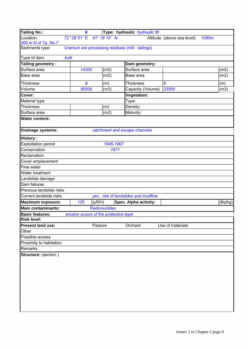
Tailing No.: 6 Type: hydraulic hydraulic fill Location: 72 °28`51``E 41° 18`10`` N Altitude (above sea level): 1085m 300 m N of Tp. No.7 Sediments type: Uranium ore processing residues (mill - tailings)
Type of dam: bulk Tailing geometry : Dam geometry: Surface area 14300 (m2) Surface area (m2) Base area (m2) Base area (m2)
Thickness 9 (m) Thickness 9 (m) Volume 80000 (m3) Capacity (Volume) 33500 (m3) Cover: Vegetation: Material type Type: Thickness (m) Density: Surface area (m2) Maturity: Water content:
Drainage systems: catchment and escape channels
History : Exploitation period 1946-1967 Conservation 1971 Reclamation Cover emplacement Free water Water treatment Landslide damage Dam failures Previous landslide risks Current landslide risks yes , risk of landslides and mudflow Maximum exposure: 125 (µR/h) Spec. Alpha activity: (Bq/kg)Main contaminants: Radionuclides Basic features: erosion scours of the protective layer Risk level: Present land use: Pasture Orchard Use of materials Other Possible access Proximity to habitation Remarks Structure: (section )
Annex 2 to Chapter 2 page 9
Mailuu Suu waste deposits characterisation -- data
Data on contamination: Sediments: Pb (mg/l) Substratum: Pb U (mg/l) Cd U (mg/l) Cd Ra As Ra As other other other other
Seepage water: Pb Interstitial water: Pb U (mg/l) Cd U (mg/l) Cd Ra As Ra As other other other other pH: pH: Particle size distribution : Groundwater
level:
Porosity: Permeabilty: Dry bulk density: Saturation degree above groundwater level :
Other physico-chemical characteristics :
Geotechnical- Geostability data :
Mineralogy: Geological setting:
Morphology: Slope of depository surface : Slope angles above depository : Slope angles of dam: Hydrogeological data:
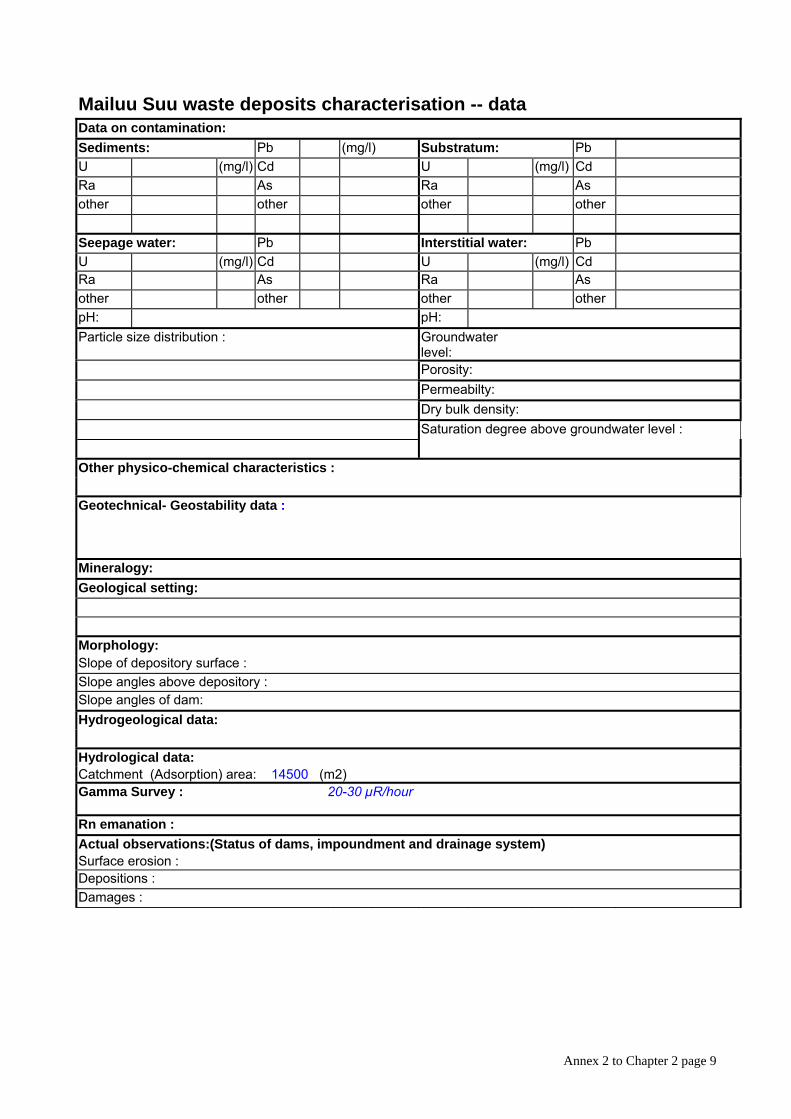
Hydrological data: Catchment (Adsorption) area: 14500 (m2) Gamma Survey : 20-30 µR/hour
Rn emanation : Actual observations:(Status of dams, impoundment and drainage system) Surface erosion : Depositions : Damages :
Annex 2 to Chapter 2 page 10
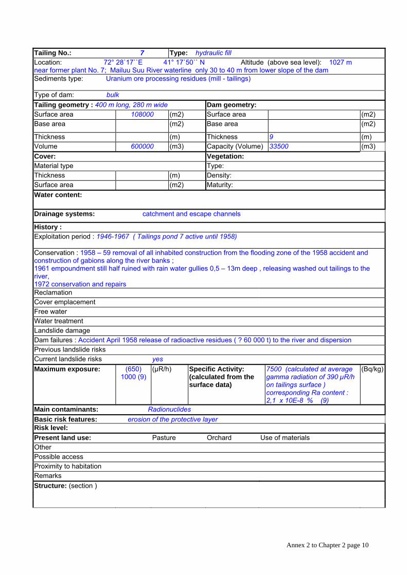
Tailing No.: 7 Type: hydraulic fill Location: 72° 28`17``E 41° 17`50`` N Altitude (above sea level): 1027 m near former plant No. 7; Mailuu Suu River waterline only 30 to 40 m from lower slope of the dam Sediments type: Uranium ore processing residues (mill - tailings)
Type of dam: bulk Tailing geometry : 400 m long, 280 m wide Dam geometry: Surface area 108000 (m2) Surface area (m2) Base area (m2) Base area (m2)
Thickness (m) Thickness 9 (m) Volume 600000 (m3) Capacity (Volume) 33500 (m3) Cover: Vegetation: Material type Type: Thickness (m) Density: Surface area (m2) Maturity: Water content:
Drainage systems: catchment and escape channels
History : Exploitation period : 1946-1967 ( Tailings pond 7 active until 1958)
Conservation : 1958 – 59 removal of all inhabited construction from the flooding zone of the 1958 accident and construction of gabions along the river banks ; 1961 empoundment still half ruined with rain water gullies 0,5 – 13m deep , releasing washed out tailings to the river, 1972 conservation and repairs Reclamation Cover emplacement Free water Water treatment Landslide damage Dam failures : Accident April 1958 release of radioactive residues ( ? 60 000 t) to the river and dispersion Previous landslide risks Current landslide risks yes Maximum exposure: (650)
1000 (9) (µR/h) Specific Activity:
(calculated from the surface data)
7500 (calculated at average gamma radiation of 390 µR/h on tailings surface ) corresponding Ra content : 2,1 x 10E-8 % (9)
(Bq/kg)
Main contaminants: Radionuclides Basic risk features: erosion of the protective layer Risk level: Present land use: Pasture Orchard Use of materials Other Possible access Proximity to habitation Remarks Structure: (section )
Annex 2 to Chapter 2 page 11
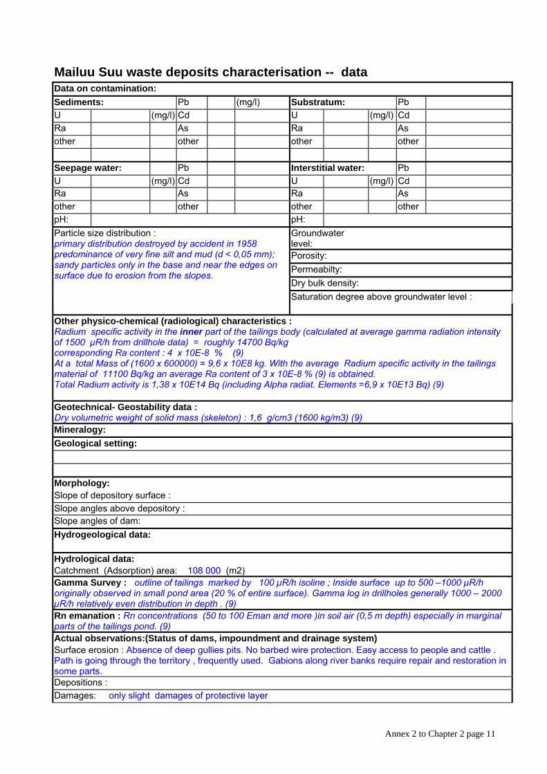
Mailuu Suu waste deposits characterisation -- data Data on contamination: Sediments: Pb (mg/l) Substratum: Pb U (mg/l) Cd U (mg/l) Cd Ra As Ra As other other other other
Seepage water: Pb Interstitial water: Pb U (mg/l) Cd U (mg/l) Cd Ra As Ra As other other other other pH: pH:
Groundwater level:
Porosity: Permeabilty: Dry bulk density: Saturation degree above groundwater level :
Particle size distribution : primary distribution destroyed by accident in 1958 predominance of very fine silt and mud (d < 0,05 mm); sandy particles only in the base and near the edges on surface due to erosion from the slopes.
Other physico-chemical (radiological) characteristics : Radium specific activity in the inner part of the tailings body (calculated at average gamma radiation intensity of 1500 µR/h from drillhole data) = roughly 14700 Bq/kg corresponding Ra content : 4 x 10E-8 % (9) At a total Mass of (1600 x 600000) = 9,6 x 10E8 kg. With the average Radium specific activity in the tailings material of 11100 Bq/kg an average Ra content of 3 x 10E-8 % (9) is obtained. Total Radium activity is 1,38 x 10E14 Bq (including Alpha radiat. Elements =6,9 x 10E13 Bq) (9)
Geotechnical- Geostability data : Dry volumetric weight of solid mass (skeleton) : 1,6 g/cm3 (1600 kg/m3) (9) Mineralogy: Geological setting:
Morphology: Slope of depository surface : Slope angles above depository : Slope angles of dam: Hydrogeological data:
Hydrological data: Catchment (Adsorption) area: 108 000 (m2) Gamma Survey : outline of tailings marked by 100 µR/h isoline ; Inside surface up to 500 –1000 µR/h originally observed in small pond area (20 % of entire surface). Gamma log in drillholes generally 1000 – 2000 µR/h relatively even distribution in depth . (9) Rn emanation : Rn concentrations (50 to 100 Eman and more )in soil air (0,5 m depth) especially in marginal parts of the tailings pond. (9) Actual observations:(Status of dams, impoundment and drainage system) Surface erosion : Absence of deep gullies pits. No barbed wire protection. Easy access to people and cattle . Path is going through the territory , frequently used. Gabions along river banks require repair and restoration in some parts. Depositions : Damages: only slight damages of protective layer
Annex 2 to Chapter 2 page 12
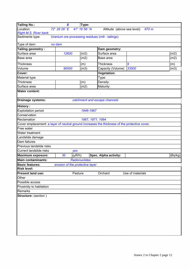
Tailing No.: 8 Type: Location: 72° 28`28``E 41° 16`56``N Altitude (above sea level): 970 m Right M.S. River bank Sediments type: Uranium ore processing residues (mill - tailings)
Type of dam: no dam Tailing geometry : Dam geometry: Surface area 12600 (m2) Surface area (m2) Base area (m2) Base area (m2)
Thickness (m) Thickness 9 (m) Volume 90000 (m3) Capacity (Volume) 33500 (m3) Cover: Vegetation: Material type Type: Thickness (m) Density: Surface area (m2) Maturity: Water content:
Drainage systems: catchment and escape channels
History : Exploitation period 1946-1967 Conservation Reclamation 1967, 1971, 1994 Cover emplacement: a layer of neutral ground increases the thickness of the protective cover. Free water Water treatment Landslide damage Dam failures Previous landslide risks Current landslide risks yes Maximum exposure: 30 (µR/h) Spec. Alpha activity: (Bq/kg)Main contaminants: Radionuclides Basic features: erosion of the protective layer Risk level: Present land use: Pasture Orchard Use of materials Other Possible access Proximity to habitation Remarks Structure: (section )
Annex 2 to Chapter 2 page 13
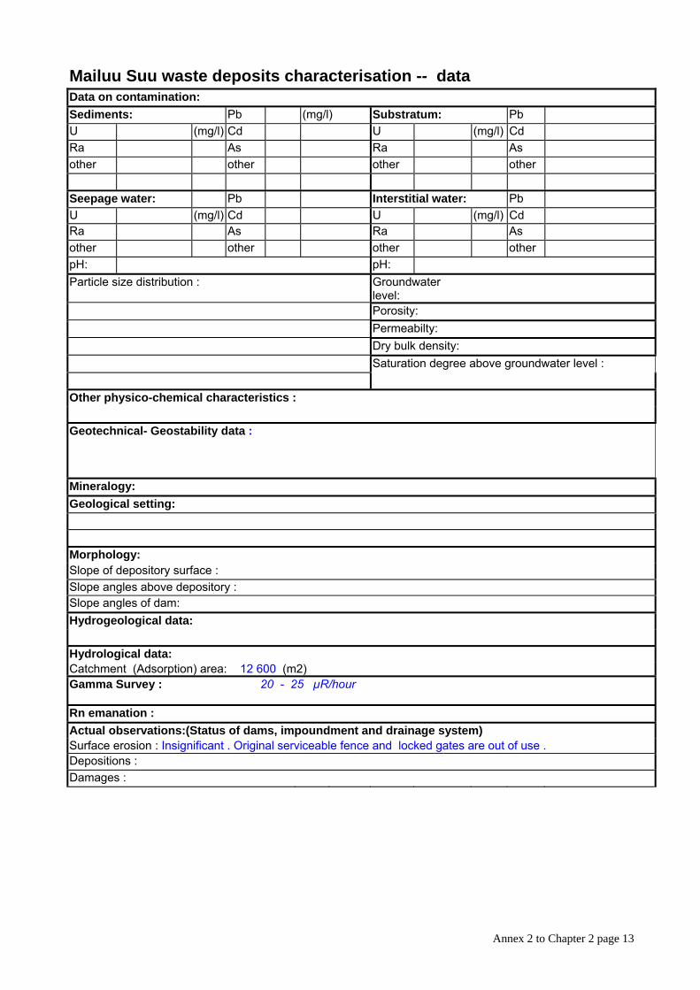
Mailuu Suu waste deposits characterisation -- data Data on contamination: Sediments: Pb (mg/l) Substratum: Pb U (mg/l) Cd U (mg/l) Cd Ra As Ra As other other other other
Seepage water: Pb Interstitial water: Pb U (mg/l) Cd U (mg/l) Cd Ra As Ra As other other other other pH: pH: Particle size distribution : Groundwater
level:
Porosity: Permeabilty: Dry bulk density: Saturation degree above groundwater level :
Other physico-chemical characteristics :
Geotechnical- Geostability data :
Mineralogy: Geological setting:
Morphology: Slope of depository surface : Slope angles above depository : Slope angles of dam: Hydrogeological data:
Hydrological data: Catchment (Adsorption) area: 12 600 (m2) Gamma Survey : 20 - 25 µR/hour
Rn emanation : Actual observations:(Status of dams, impoundment and drainage system) Surface erosion : Insignificant . Original serviceable fence and locked gates are out of use . Depositions : Damages :
Annex 2 to Chapter 2 page 14
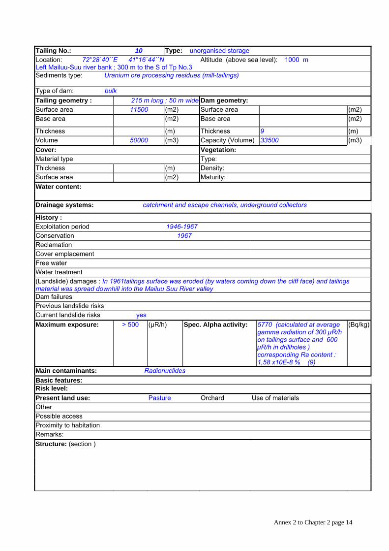
Tailing No.: 10 Type: unorganised storage Location: 72°28`40``E 41°16`44``N Altitude (above sea level): 1000 m Left Mailuu-Suu river bank ; 300 m to the S of Tp No.3 Sediments type: Uranium ore processing residues (mill-tailings)
Type of dam: bulk Tailing geometry : 215 m long ; 50 m wide Dam geometry: Surface area 11500 (m2) Surface area (m2) Base area (m2) Base area (m2)
Thickness (m) Thickness 9 (m) Volume 50000 (m3) Capacity (Volume) 33500 (m3) Cover: Vegetation: Material type Type: Thickness (m) Density: Surface area (m2) Maturity: Water content:
Drainage systems: catchment and escape channels, underground collectors
History : Exploitation period 1946-1967 Conservation 1967 Reclamation Cover emplacement Free water Water treatment (Landslide) damages : In 1961tailings surface was eroded (by waters coming down the cliff face) and tailings material was spread downhill into the Mailuu Suu River valley Dam failures Previous landslide risks Current landslide risks yes Maximum exposure: > 500 (µR/h) Spec. Alpha activity: 5770 (calculated at average
gamma radiation of 300 µR/h on tailings surface and 600 µR/h in drillholes ) corresponding Ra content : 1,58 x10E-8 % (9)
(Bq/kg)
Main contaminants: Radionuclides Basic features: Risk level: Present land use: Pasture Orchard Use of materials Other Possible access Proximity to habitation Remarks: Structure: (section )

Annex 2 to Chapter 2 page 15
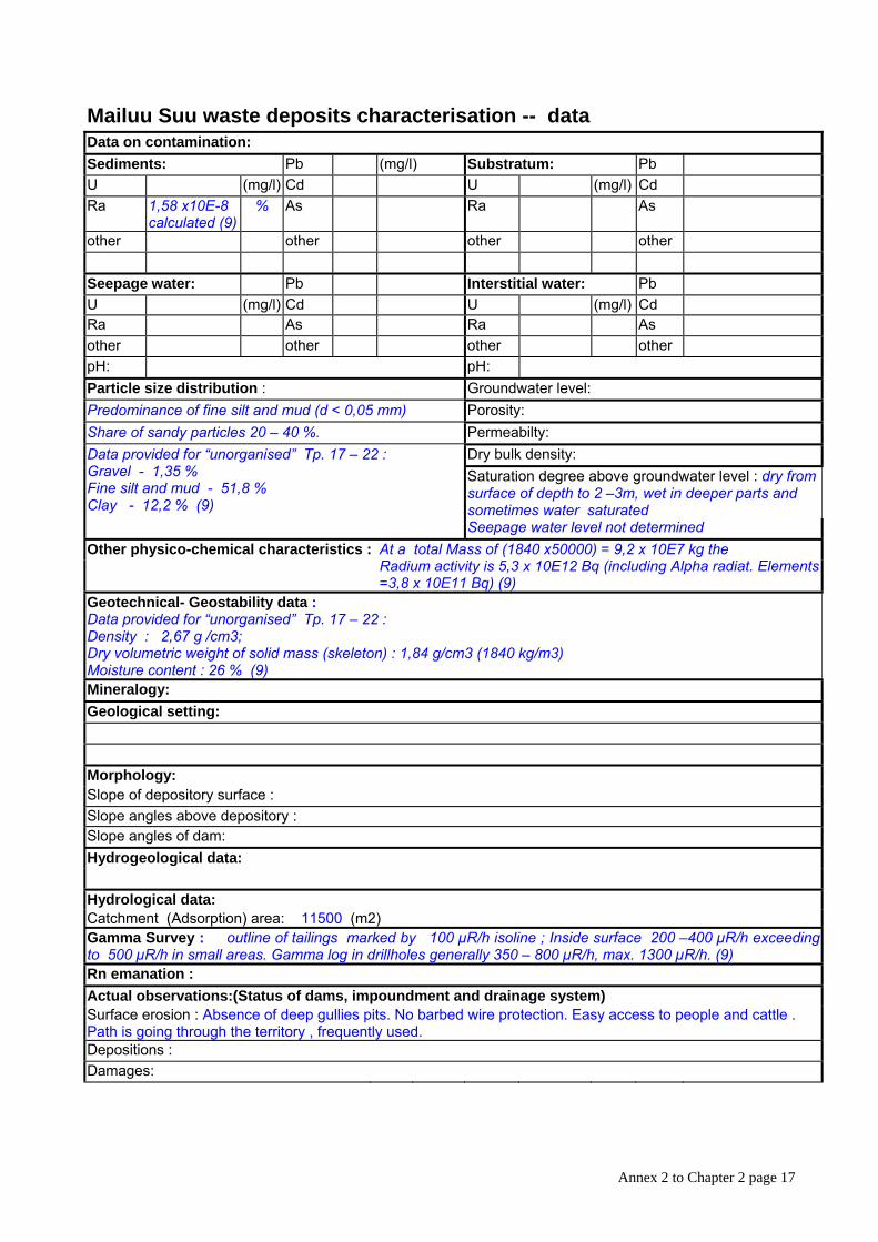
Mailuu Suu waste deposits characterisation -- data Data on contamination: Sediments: Pb (mg/l) Substratum: Pb U (mg/l) Cd U (mg/l) Cd Ra 1,58 x10E-8
calculated (9) % As Ra As
other other other other
Seepage water: Pb Interstitial water: Pb U (mg/l) Cd U (mg/l) Cd Ra As Ra As other other other other pH: pH: Particle size distribution : Groundwater level: Predominance of fine silt and mud (d < 0,05 mm) Porosity: Share of sandy particles 20 – 40 %. Permeabilty:
Dry bulk density: Saturation degree above groundwater level : dry from surface of depth to 2 –3m, wet in deeper parts and sometimes water saturated
Data provided for “unorganised” Tp. 17 – 22 : Gravel - 1,35 % Fine silt and mud - 51,8 % Clay - 12,2 % (9)
Seepage water level not determined Other physico-chemical characteristics :
At a total Mass of (1840 x50000) = 9,2 x 10E7 kg the Radium activity is 5,3 x 10E12 Bq (including Alpha radiat. Elements =3,8 x 10E11 Bq) (9)
Geotechnical- Geostability data : Data provided for “unorganised” Tp. 17 – 22 : Density : 2,67 g /cm3; Dry volumetric weight of solid mass (skeleton) : 1,84 g/cm3 (1840 kg/m3) Moisture content : 26 % (9) Mineralogy: Geological setting:
Morphology: Slope of depository surface : Slope angles above depository : Slope angles of dam: Hydrogeological data:
Hydrological data: Catchment (Adsorption) area: 11500 (m2) Gamma Survey : outline of tailings marked by 100 µR/h isoline ; Inside surface 200 –400 µR/h exceeding to 500 µR/h in small areas. Gamma log in drillholes generally 350 – 800 µR/h, max. 1300 µR/h. (9) Rn emanation : Actual observations:(Status of dams, impoundment and drainage system) Surface erosion : Absence of deep gullies pits. No barbed wire protection. Easy access to people and cattle . Path is going through the territory , frequently used. Depositions : Damages:

Annex 2 to Chapter 2 page 16
Tailing No.: 10 Type: unorganised storage Location: 72°28`40``E 41°16`44``N Altitude (above sea level): 1000 m Left Mailuu-Suu river bank ; 300 m to the S of Tp No.3 Sediments type: Uranium ore processing residues (mill-tailings)
Type of dam: bulk Tailing geometry : 215 m long ; 50 m wide Dam geometry: Surface area 11500 (m2) Surface area (m2) Base area (m2) Base area (m2)
Thickness (m) Thickness 9 (m) Volume 50000 (m3) Capacity (Volume) 33500 (m3) Cover: Vegetation: Material type Type: Thickness (m) Density: Surface area (m2) Maturity: Water content:
Drainage systems: catchment and escape channels, underground collectors
History : Exploitation period 1946-1967 Conservation 1967 Reclamation Cover emplacement Free water Water treatment (Landslide) damages : In 1961tailings surface was eroded (by waters coming down the cliff face) and tailings material was spread downhill into the Mailuu Suu River valley Dam failures Previous landslide risks Current landslide risks yes Maximum exposure: > 500 (µR/h) Spec. Alpha activity: 5770 (calculated at average
gamma radiation of 300 µR/h on tailings surface and 600 µR/h in drillholes ) corresponding Ra content : 1,58 x10E-8 % (9)
(Bq/kg)
Main contaminants: Radionuclides Basic features: Risk level: Present land use: Pasture Orchard Use of materials Other Possible access Proximity to habitation Remarks: Structure: (section )
Annex 2 to Chapter 2 page 17
Mailuu Suu waste deposits characterisation -- data Data on contamination: Sediments: Pb (mg/l) Substratum: Pb U (mg/l) Cd U (mg/l) Cd Ra 1,58 x10E-8
calculated (9) % As Ra As
other other other other
Seepage water: Pb Interstitial water: Pb U (mg/l) Cd U (mg/l) Cd Ra As Ra As other other other other pH: pH: Particle size distribution : Groundwater level: Predominance of fine silt and mud (d < 0,05 mm) Porosity: Share of sandy particles 20 – 40 %. Permeabilty:
Dry bulk density: Saturation degree above groundwater level : dry from surface of depth to 2 –3m, wet in deeper parts and sometimes water saturated
Data provided for “unorganised” Tp. 17 – 22 : Gravel - 1,35 % Fine silt and mud - 51,8 % Clay - 12,2 % (9)
Seepage water level not determined Other physico-chemical characteristics :
At a total Mass of (1840 x50000) = 9,2 x 10E7 kg the Radium activity is 5,3 x 10E12 Bq (including Alpha radiat. Elements =3,8 x 10E11 Bq) (9)
Geotechnical- Geostability data : Data provided for “unorganised” Tp. 17 – 22 : Density : 2,67 g /cm3; Dry volumetric weight of solid mass (skeleton) : 1,84 g/cm3 (1840 kg/m3) Moisture content : 26 % (9) Mineralogy: Geological setting:
Morphology: Slope of depository surface : Slope angles above depository : Slope angles of dam: Hydrogeological data:
Hydrological data: Catchment (Adsorption) area: 11500 (m2) Gamma Survey : outline of tailings marked by 100 µR/h isoline ; Inside surface 200 –400 µR/h exceeding to 500 µR/h in small areas. Gamma log in drillholes generally 350 – 800 µR/h, max. 1300 µR/h. (9) Rn emanation : Actual observations:(Status of dams, impoundment and drainage system) Surface erosion : Absence of deep gullies pits. No barbed wire protection. Easy access to people and cattle . Path is going through the territory , frequently used. Depositions : Damages:
Annex 2 to Chapter 2 page 18
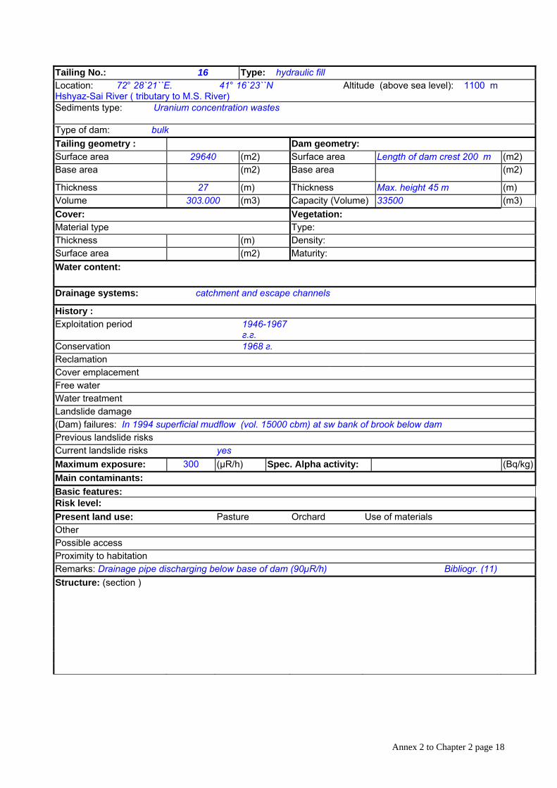
Tailing No.: 16 Type: hydraulic fill Location: 72° 28`21``E. 41° 16`23``N Altitude (above sea level): 1100 m Hshyaz-Sai River ( tributary to M.S. River) Sediments type: Uranium concentration wastes
Type of dam: bulk Tailing geometry : Dam geometry: Surface area 29640 (m2) Surface area Length of dam crest 200 m (m2) Base area (m2) Base area (m2)
Thickness 27 (m) Thickness Max. height 45 m (m) Volume 303.000 (m3) Capacity (Volume) 33500 (m3) Cover: Vegetation: Material type Type: Thickness (m) Density: Surface area (m2) Maturity: Water content:
Drainage systems: catchment and escape channels
History : Exploitation period 1946-1967
г.г. Conservation 1968 г. Reclamation Cover emplacement Free water Water treatment Landslide damage (Dam) failures: In 1994 superficial mudflow (vol. 15000 cbm) at sw bank of brook below dam Previous landslide risks Current landslide risks yes Maximum exposure: 300 (µR/h) Spec. Alpha activity: (Bq/kg)Main contaminants: Basic features: Risk level: Present land use: Pasture Orchard Use of materials Other Possible access Proximity to habitation Remarks: Drainage pipe discharging below base of dam (90µR/h) Bibliogr. (11) Structure: (section )

Annex 2 to Chapter 2 page 19
Mailuu Suu waste deposits characterisation -- data Data on contamination: Sediments: Pb (mg/l) Substratum: Pb U (mg/l) Cd U (mg/l) Cd Ra As Ra As other other other other
Seepage water: Pb Interstitial water: Pb U (mg/l) Cd U (mg/l) Cd Ra As Ra As other other other other pH: pH: Particle size distribution : Groundwater
level:
Porosity: Permeabilty: Dry bulk density: Saturation degree above groundwater level :
Other physico-chemical characteristics :
Geotechnical- Geostability data :
Mineralogy: Geological setting:
Morphology: Slope of depository surface : Slope angles above depository : Slope angles of dam: Hydrogeological data:
Hydrological data: Catchment (Adsorption) area: 29640 (m2) Gamma Survey : 15-20 µR/hour
Rn emanation : Actual observations:(Status of dams, impoundment and drainage system) Surface erosion : Depositions : Damages:
Annex 2 to Chapter 2 page 20
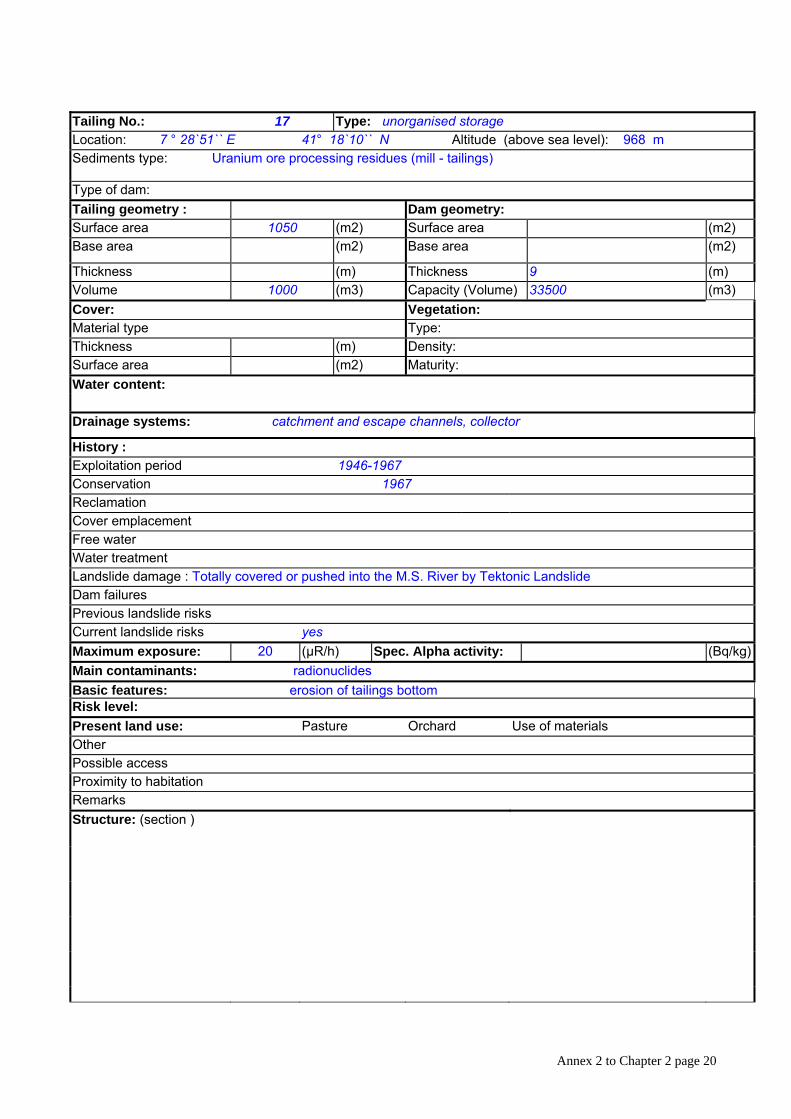
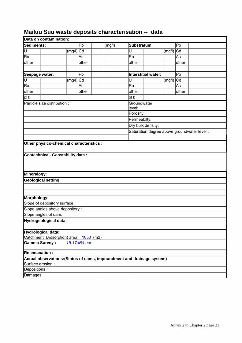
Tailing No.: 17 Type: unorganised storage Location: 7 ° 28`51`` E 41° 18`10`` N Altitude (above sea level): 968 m Sediments type: Uranium ore processing residues (mill - tailings)
Type of dam: Tailing geometry : Dam geometry: Surface area 1050 (m2) Surface area (m2) Base area (m2) Base area (m2)
Thickness (m) Thickness 9 (m) Volume 1000 (m3) Capacity (Volume) 33500 (m3) Cover: Vegetation: Material type Type: Thickness (m) Density: Surface area (m2) Maturity: Water content:
Drainage systems: catchment and escape channels, collector
History : Exploitation period 1946-1967 Conservation 1967Reclamation Cover emplacement Free water Water treatment Landslide damage : Totally covered or pushed into the M.S. River by Tektonic Landslide Dam failures Previous landslide risks Current landslide risks yes Maximum exposure: 20 (µR/h) Spec. Alpha activity: (Bq/kg)Main contaminants: radionuclides Basic features: erosion of tailings bottom Risk level: Present land use: Pasture Orchard Use of materials Other Possible access Proximity to habitation Remarks Structure: (section )
Annex 2 to Chapter 2 page 21
Mailuu Suu waste deposits characterisation -- data Data on contamination: Sediments: Pb (mg/l) Substratum: Pb U (mg/l) Cd U (mg/l) Cd Ra As Ra As other other other other
Seepage water: Pb Interstitial water: Pb U (mg/l) Cd U (mg/l) Cd Ra As Ra As other other other other pH: pH: Particle size distribution : Groundwater
level:
Porosity: Permeabilty: Dry bulk density: Saturation degree above groundwater level :
Other physico-chemical characteristics :
Geotechnical- Geostability data :
Mineralogy: Geological setting:
Morphology: Slope of depository surface : Slope angles above depository : Slope angles of dam: Hydrogeological data:
Hydrological data: Catchment (Adsorption) area: 1050 (m2) Gamma Survey : 15-17µR/hour
Rn emanation : Actual observations:(Status of dams, impoundment and drainage system) Surface erosion : Depositions : Damages:
Annex 2 to Chapter 2 page 22
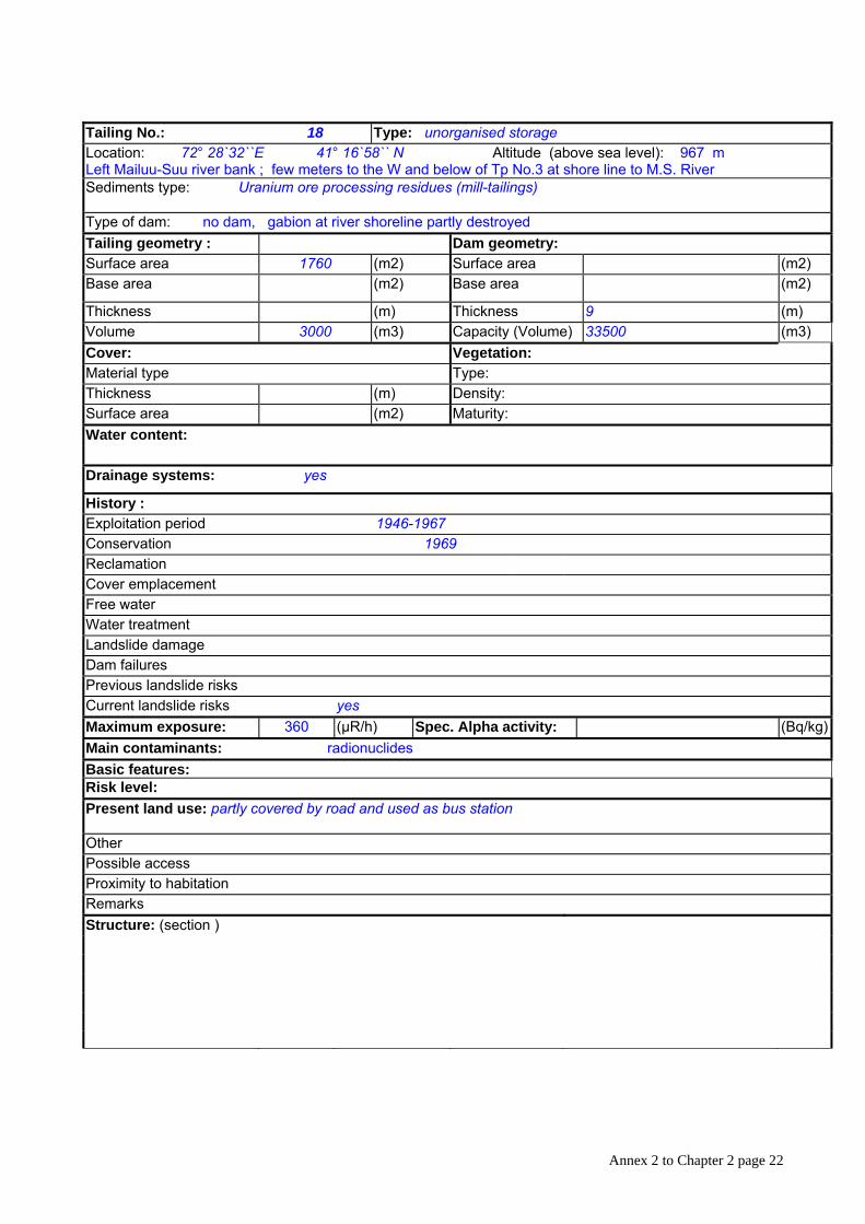
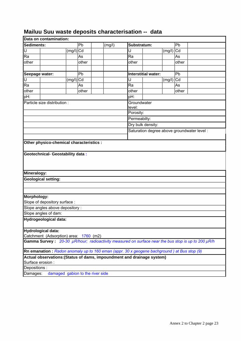
Tailing No.: 18 Type: unorganised storage Location: 72° 28`32``E 41° 16`58`` N Altitude (above sea level): 967 m Left Mailuu-Suu river bank ; few meters to the W and below of Tp No.3 at shore line to M.S. River Sediments type: Uranium ore processing residues (mill-tailings)
Type of dam: no dam, gabion at river shoreline partly destroyed Tailing geometry : Dam geometry: Surface area 1760 (m2) Surface area (m2) Base area (m2) Base area (m2)
Thickness (m) Thickness 9 (m) Volume 3000 (m3) Capacity (Volume) 33500 (m3) Cover: Vegetation: Material type Type: Thickness (m) Density: Surface area (m2) Maturity: Water content:
Drainage systems: yes
History : Exploitation period 1946-1967 Conservation 1969Reclamation Cover emplacement Free water Water treatment Landslide damage Dam failures Previous landslide risks Current landslide risks yes Maximum exposure: 360 (µR/h) Spec. Alpha activity: (Bq/kg)Main contaminants: radionuclides Basic features: Risk level: Present land use: partly covered by road and used as bus station
Other Possible access Proximity to habitation Remarks Structure: (section )
Annex 2 to Chapter 2 page 23
Mailuu Suu waste deposits characterisation -- data Data on contamination: Sediments: Pb (mg/l) Substratum: Pb U (mg/l) Cd U (mg/l) Cd Ra As Ra As other other other other
Seepage water: Pb Interstitial water: Pb U (mg/l) Cd U (mg/l) Cd Ra As Ra As other other other other pH: pH: Particle size distribution : Groundwater
level:
Porosity: Permeabilty: Dry bulk density: Saturation degree above groundwater level :
Other physico-chemical characteristics :
Geotechnical- Geostability data :
Mineralogy: Geological setting:
Morphology: Slope of depository surface : Slope angles above depository : Slope angles of dam: Hydrogeological data:
Hydrological data: Catchment (Adsorption) area: 1760 (m2) Gamma Survey : 20-30 µR/hour; radioactivity measured on surface near the bus stop is up to 200 µR/h
Rn emanation : Radon anomaly up to 160 eman (appr. 30 x geogene bachground ) at Bus stop (9) Actual observations:(Status of dams, impoundment and drainage system) Surface erosion : Depositions : Damages: damaged gabion to the river side
Annex 2 to Chapter 2 page 24
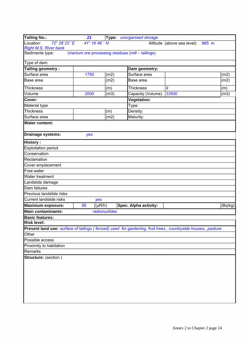
Tailing No.: 21 Type: unorganised storage Location: 72° 28`22``E 41° 16`46`` N Altitude (above sea level): 965 m Right M.S. River bank Sediments type: Uranium ore processing residues (mill – tailings)
Type of dam: Tailing geometry : Dam geometry: Surface area 1750 (m2) Surface area (m2) Base area (m2) Base area (m2)
Thickness (m) Thickness 9 (m) Volume 2000 (m3) Capacity (Volume) 33500 (m3) Cover: Vegetation: Material type Type: Thickness (m) Density: Surface area (m2) Maturity: Water content:
Drainage systems: yes
History : Exploitation period Conservation Reclamation Cover emplacement Free water Water treatment Landslide damage Dam failures Previous landslide risks Current landslide risks yes Maximum exposure: 95 (µR/h) Spec. Alpha activity: (Bq/kg)Main contaminants: radionuclides Basic features: Risk level: Present land use: surface of tailings ( fenced) used for gardening, fruit trees , countryside houses, ,pasture Other Possible access Proximity to habitation Remarks Structure: (section )

Annex 2 to Chapter 2 page 25
Mailuu Suu waste deposits characterisation -- data Data on contamination: Sediments: Pb (mg/l) Substratum: Pb U (mg/l) Cd U (mg/l) Cd Ra As Ra As other other other other
Seepage water: Pb Interstitial water: Pb U (mg/l) Cd U (mg/l) Cd Ra As Ra As other other other other pH: pH: Particle size distribution : Groundwater
level:
Porosity: Permeabilty: Dry bulk density: Saturation degree above groundwater level :
Other physico-chemical characteristics :
Geotechnical- Geostability data :
Mineralogy: Geological setting:
Morphology: Slope of depository surface : Slope angles above depository : Slope angles of dam: Hydrogeological data:
Hydrological data: Catchment (Adsorption) area: 1750 (m2) Gamma Survey : 30-60 µR/hour
Rn emanation : Actual observations:(Status of dams, impoundment and drainage system) Surface erosion : Depositions : Damages: