Embed Size (px)
Citation preview

Planned Villages and Rural Resilience on the Mamluk Frontier:A Preliminary Report on the 2013 Excavation Season at Tall Hisban
Bethany Walker
Bonn, August 2013ISSN 2193-925X
Ann
emar
ie S
chim
mel
Kol
leg
ASK Working Paper11

ASK Working Paper, ISSN 2193-925X
Annemarie Schimmel Kolleg
History and Society during the
Mamluk Era (1250-1517)
Heussallee 18-24
53115 Bonn
Editor: Stephan Conermann
Author’s address
Prof. Dr. Bethany Walker
Annemarie-Schimmel-Kolleg
“History and Society during the Mamluk Era, 1250-1517”
Heussallee 18-24
53113 Bonn
Telephone: 0228/7362946
Fax: 0228/7362964
Email: [email protected]
Website: www.mamluk.uni-bonn.de

Planned Villages and Rural Resilience on the Mamluk Frontier:
A Preliminary Report on the 2013 Excavation Season at Tall Hisban
by Bethany J. Walker (Bonn)
About the author
Bethany Walker is Research Professor of Mamluk Studies at the Annemarie Schimmel Kolleg of the
University of Bonn. She received her Ph.D. in Middle Eastern Studies from the University of Toronto in
1998 and previously held professorships at Oklahoma State University, Grand Valley State University,
and Missouri State University in the U.S. before coming to Bonn.
A historically trained archaeologist, Walker directs two long-term field projects in Jordan and actively
consults on Crusader and Islamic ceramics at eastern Mediterranean sites. She is founding editor of the
newly launched Journal of Islamic Archaeology and serves on numerous American and French editorial
boards, including Mamluk Studies Review. She is a Board member of the American Center of Oriental
Research in Amman and former Board member of the American Schools of Oriental Research.
Walker’s current research centers on rural society and migration in the Mamluk period, environmental
and agricultural history, and frontier and resilience studies.
Among her recent publications are:
- “The Islamic Age”, in: Hesban 11: The Pottery, ed. Larry Herr, Berrien Springs, MI: Andrews
University Press, 2012, pp. 507-594.
- Jordan in the Late Middle Ages: Transformation of the Mamluk Frontier, Chicago: Middle East
Documentation Center, University of Chicago, Chicago Studies on the Middle East Monograph
Series, 2011.
- Reflections of Empire: Archaeological and Ethnographic Studies on the Pottery of the Ottoman
Levant, Boston: ASOR, Annual of the American School of Oriental Research, #64, 2009. (an edited
work)
- Le pouvoir à l’âge des sultanats dans le Bilâd al-Shâm, Proceedings from the IFPO-ACOR
Conference of same title, 13-15 May 2005, Amman; Published under Bulletin des Études Orientales
57, supplement (2008); Damascus. (Co-edited with Jean-François Salles).
- “Soils and Land Use in the Decapolis Region (Northern Jordan): Implications for landscape
development and the Impact of Climate Change,” Zeitschrift der Deutschen Palaestina-Vereins 124/2
(2008), pp. 171-188. (co-written with Bernhard Lucke – lead author, Ziad al-Saad, Michael Schmidt,
Rupert Bäumler, Sven Oliver Lorenz, Peter Udluft, and Kark Uwe Heussner).
- “Rural Sufism as Channels of Charity in Nineteenth-Century Jordan,” in: Interpreting Welfare and
Relief in the Middle East, ed. Nefissa Naguib and Inger Marie Okkenhaug. Social, Economic and
Political Studies of the Middle East and Asia, vol. 103. Leiden: Brill, 2007, pp. 217-234.

Abstract 1
I. Introduction 2
II. Tall Ḥisbān (the archeological site) 6
III. History of the Archeological Project 9
IV Result of the 2013 Excavation season 10
The town and village 11
Filed M – Figs. 7 and 8 13
Field C – Figs. 9-11 15
Field O – Figs. 12-13 18
Field B – Figs. 14 and 15 19
Field R 21
Spolia project 22
Agriculture, water management, and the environment 22
V. Conclusions 26
Literature 29
1
Abstract
There is a considerable body of literature today on urban space in Mamluk studies. This is in
large part due to the nature and survival of the textual sources, which reflect an urban bias and
are preserved in city archives. Architectural studies of Mamluk cities also abound, as many
monuments and even entire neighborhoods of the period have been preserved in the urban fabric
of modern Cairo, Damascus, Aleppo, and Jerusalem. The same cannot be said, however, about
the rural lands under Mamluk rule - namely settlements of village and sub-village size – about
which we know precious little. While textual sources, and particularly documentary ones, can
produce some information about rural life, if they are carefully mined, it is the archaeological
record that offers us the greatest promise for reconstructing the physical structure of rural
settlements, their function(s) and development over time, and details of the lives of the people
who lived there. The focus of the 2013 excavation season at Tall Hisban, co-sponsored by the
Annemarie Schimmel Kolleg of the University of Bonn, was to investigate the settlement
associated with the Mamluk citadel and to explore the many factors that may have contribute to
its growth, decline, and transformation over time.
The following essay is a preliminary, non-technical assessment of that fieldwork, highlighting
the most important results relevant to a study of Mamluk-era rural life and raising important
questions about changing relations between state and village in the seventh/ fourteenth century.

2
I. Introduction
The study of “place” is relatively underdeveloped in Mamluk studies.1 The existing
literature privileges urban contexts, focusing on public monuments and urban planning (made
possible by the preservation of buildings, and the waqfiyyāt that describe them) and the
intellectual and professional networks of those urban centers (one result of the traditional
Mamlukist obsession with biographical dictionaries). We know comparatively less about the
rural places of the Mamluks’ realms. Notable exceptions are the frontier and castle towns (Qus
and Karak) and ports (Quseir al-Qadim), research on which has tended to pull on both narrative
sources and archaeological fieldwork.2 As quasi-urban sites, however, they reveal little about the
pulse of traditional rural life. Some inroads into what could be properly described as “rural
Mamluk studies” have been made by Arab historians interested in local history. Noteworthy in
this regard is the work of Yusuf Ghanwanmah on Transjordan and ‘Athāminah for Palestine.3
While targeted study of villages and village life has languished among Mamluk
historians, there are emerging areas of research that could potentially facilitate the study of rural
societies. Scholarship on land tenure - the natural outgrowth of iqṭāʿ and waqf studies - offers an
important window on the ways socio-political and economic relations changed in the countryside
over the course of Mamluk rule.4 If future scholarship on this topic goes beyond the state
perspective and turns, instead, to the impact of the waqfization of the countryside on local
communities, for example, this could be a real area of growth in the field. The “environmental
turn”, which has found a place in nearly every discipline of the social sciences and humanities, is
impacting Mamluk studies in an oblique way, namely through recent publications on water
conflicts (albeit urban ones), water management, and land management and agro-business (with
a special focus on the sugar industry).5 Within urban studies, a new focus on the household –
1 I can think of only work to date that has dealt with a medieval Islamic “discourse of place” is Antrim, Routes and
Realms, for the early Islamic centuries. This kind of work has yet to be done for the Mamluk period. 2 Garçin’s Un centre musulmane remains a milestone in the study of rural society, even though the archaeological
work planned for Qus did not take place. For Karak, one notes Milwright’s recent Fortress of the Raven, which
examines the changing roles of this castle town through its ceramic record. For complementary textual and
archaeological studies of Quseir al-Qadim, the port of Qus, see Guo, Commerce, Culture, and Community and
Strange Burke, Archaeological Texts and Contexts. 3 For Ghawanmah, take special note of his Tarīkh Sharqi al-Urdunn and “al-Qarya fī Junūb al-Shām“. A review of
his work and list of his publications can be found in Walker, Jordan in the Late Middle Ages, 16 and 306-307. For
‘Athāminah, see his Filisṭīn fi al-‘Ahdayn al-Ayyūbī wa al-Mamlūkī. Every year new M.A. theses and doctoral
dissertations are produced by Palestinian and Jordanian students on a range of topics related to local history,
including tribal and village history. Relevant to the topic at hand are two recent M.A. theses at Yarmouk University,
both written under the supervision of Prof. Ghawanmah: Maqablah “al-Qarya fī Bilād al-Shām” and Mukahalah, “al-
Zirāʿah fī Bilād al-Shām”. 4 Petry, Protectors or Praetorians, 196-210; ibid, “Fractionalized Estates”; ibid, “Waqf as an Instrument of
Investment”; Abu Ghāzī, Taṭawwur al-Ḥiyāzah; Sabra, “Rise of a new Class?”; Frenkel, “Agriculture, Land Tenure,
and Peasants. 5 Shoshan, “Mini-Dramas by the Water”; Frenkel, Management of Water (many thanks to the author sharing this
paper with me); Levanoni, “Water Supply in Medieval Middle Eastern Cities”; Borsch, “Environment and
Population”; Sato, State and Rural Society; Ouerfelli;:Le sucre.

3
women in Mamluk society, family, marriage, health and hunger, food and cooking – offers, as
well, promising venues of inquiry applicable to the study of the rural sphere.6
What is missing at this point in the developing scholarship on rural society under
Mamluk rule, however, is an engagement with rural communities – as living entities on their
own and not merely extensions of urban society – and the spaces they inhabited. Archaeological
methods are ideally suited to spatial analysis and the study of rural landscapes and non-urban
communities, as the archaeological record preserves the kinds of data relevant to rural life that
are not readily retrievable from the written record available to Mamluk historians.7
Archaeological research on Mamluk-era rural society has, to date, followed two trajectories:
cross-disciplinary study of settlement distribution8, landscapes, and travel
9; and excavations of
rural centers of industry (sugar being prominent) 10
and villages (seldom preserved). Large-scale
excavations of villages of the Mamluk period are generally concentrated in today’s Jordan (Fig.
1). There are many reasons why this is so, not the least of which is the special history of
settlement in the region, in which many towns and villages were abandoned at the end of the
Mamluk period and never reoccupied on any long-term basis. The architectural ruins left behind
in this manner, and free of major building activity in later periods, present a moment in time – a
unique record of village history from which to reconstruct the lives of rural communities under
Mamluk rule. The most important, long-term excavations of Mamluk-era villages in Jordan
include Khirbat Fāris, on the Karak Plateau11
; Dhibān, on the Dhibān Plateau12
; and Ḥisbān, on
6 Rapoport, Marriage, Money and Divorce; Sabra, Poverty and Charity; Levanoni, “Food and Cooking during the
Mamluk Era”; Lewicka, Food and Foodways of Medieval Cairenes. Also ongoing work by Syrinx von Hees’ on old
age and images of growing old in Mamluk literature is an important contribution to this kind of scholarship. 7 Mamluk archaeology is a relatively recent area of specialization within Islamic archaeology. For reviews of the
state of the field, see Whitcomb, “Mamluk Archaeological Studies”; Walker, “From Ceramics to Social Theory”;
ibid, “What Can Archaeology Contribute to the New Mamlukology?”; and ibid, “On Archives and Archaeology”. 8 Archaeological study of rural societies of the Islamic period in general has relied primarily on survey, rather than
excavation. The reason is the poor preservation, and relative ephemeral nature, of non-urban sites of the period. For
a review of the state-of-the-field of survey work in Jordan related to Mamluk archaeology, see Walker, Jordan in the
Late Middle Ages, 211-232. 9 Particularly fruitful has been scholarship related to historical cartography, the institutions and infrastructure of
rural travel, and the mechanisms of movement and migration, as studied through textual sources, architecture and
roads, travelers’ inscriptions, and archaeological survey. Recent contributions to this kind of work include Franz,
“Ayyubid and Mamluk Reevaluation”; ibid, Atlas der Beduinen unter dem Sultanat; Cytryn Silverman, The Road
Inns; and Abu Mustafa, Trade Routes in Palestine. The rapidly expanding literature on travelers’ inscriptions is
documenting the movements of non-Bedouin populations – merchants, pilgrims, the politically displaced, and
economic migrants. For Jordan, these include Baramki, “al-Nuqūsh al-ʿarabīyyah”; al-Jbour, Étude des
inscriptions”; ibid, “Bayyān asʿār al-ḥinṭah”; al-Salameen and al-Falahat,“Jabal Haroun during the Islamic Period”;
al-Salameen et al, “New Arabic-Christian Inscriptions”. Such reports result from archaeological epigraphic surveys,
and the most promising for Mamluk studies are those being conducted by Yarmouk University and its affiliates in
the eastern desert of Jordan (the bādiyyah). My on-going work on human migration in the late Mamluk period
(Walker, “Mobility and Migration”, for example) also belongs to this body of scholarship. 10
For archaeological studies of sugar production in Mamluk Jordan, see Kareem, Settlement Patterns in the Jordan
Valley; Strange Burke, “Archaeological Evidence for Sugar Production”; and Politis’ forthcoming Archaeological
Landscapes of Zoara. For mining and the possible relationship between copper and sugar production, see Jones et al,
“Khirbat Nuqayb al-Asaymir”. 11
McQuitty, “Khirbat Faris”. See also article bibliography for a larger list of project publications, including
technical reports.

4
the Madaba Plains13
. All three sites occupied prominent positions on rich, grain-producing
highland plateaus; all were first settled deep in antiquity, with particular occupational peaks in
the 14th
century CE; each was eventually (and gradually, it seems) abandoned by the 15th
century. Only Ḥisbān, however, grew to the status of a town (madīnah) in the Mamluk period,
according to contemporary Arabic sources, and held the administrative status of a district capital.
Fig. 1 – Map of Mamluk Jordan, courtesy of Michael Brandt, Springfield, MO
12
Porter, “Locating Middle Islamic Dhiban”. The project website (www.dhiban.org) also lists full excavation
reports and forthcoming publications. 13
A list of project publications, past and present, can be found at the project website:
http://www.madabaplains.org/Ḥisbān/. For archaeological reports most relevant to Mamluk-era occupation, see
Walker and LaBianca, “Urban Bias”; ibid, “The Islamic Qusur”; ibid, “Tall Ḥisbān, 2004”; ibid, “Tall Ḥisbān, 2004
–An Investigation”; ibid, “Tall Ḥisbān, 2007”; ibid, “Tall Ḥisbān, 2010. For ceramics, see Walker, “The Islamic
Age”, 547-587.

5
What follows is a Mamlukist’s interpretation of the results of recent excavations at Tall
Ḥisbān, one of the most important rural sites of the Middle Islamic period in Bilād al-Shām (Fig.
2).14
Sections of the text are pulled, and adapted, from the stratigraphic report submitted by the
author to the Jordanian Department of Antiquities at the conclusion of the 2013 field season.15
The text presented here concerns only data relevant to Mamluk studies and represents the
excavation director’s initial impressions of the field season. The three-week excavation that
produced that report was designed, in part, to explore one phenomenon in settlement suggested
by contemporary sources, namely that the Mamuk state occasionally, and haphazardly,
intervened in village life, when needed, to create and dissolve village communities.16
Potential
factors behind the cycles of expansion and abatement of settlement documented archaeologically
at Ḥisbān are evaluated in this light.
Comparison of Historical and Archaeological Periodizations (Fig. 2)
Political Cultural Christian calendar
Ottoman Late Islamic II Early 16th c. to Early 20th c. A.D. Mamluk Middle Islamic II-Late Islamic I Mid 13th c. to Early 16th c. A.D.
Ayyubid Middle Islamic I Late 12th c. to Late 13th c. A.D.
Crusader Middle Islamic I Late 11th c. to Late 13th c. A.D. Fatimid Early Islamic II-Middle Islamic I Mid 10th c. to Late 12th c. A.D.
Abbasid Early Islamic I-II Mid 8th c. to Mid 10th c. A.D.
Umayyad Early Islamic I Mid 7th c. to Mid 8th c. A.D. Byzantine Early 4th c. to Mid 7th c. A.D.
Late Roman Early 2nd c. to Early 4th c. A.D. Early Roman Mid 1st c. B.C. to Early 2nd c. A.D.
Hellenistic Late 4th c. to Mid 1st c. B.C.
Persian Late 6th c. to Late 4th c. B.C.
Iron Age Late 13th c. to Late 6th c. B.C.
Late Bronze Age Mid 16th c. to Late 13th c. B.C. Middle Bronze 20th c. to Mid 16th c. B.C.
Early Bronze ca. 3200-2000 B.C.
Chalcolithic ca. 4500-3200 B.C. Neolithic ca. 8000-4500 B.C.
Paleolithic Before ca. 8000 B.C
14
The political and calendar chronologies adopted by historians are generally rejected by archaeologists, as material
culture does not necessarily change with political transitions. Archaeologists working on the Islamic periods in
southern Bilād al-Shām generally adopt a cultural chronology reflecting very broad cultural transitions. The
centuries of the Mamluk Sultanate correspond, accordingly, to the later Middle Islamic and early Late Islamic
periods. 15
The Field and Square Supervisors and Specialists all contributed to the stratigraphic report. I want to acknowledge
in this regard the special efforts of Prof. Bob Bates, Jeff Hudon, and Doneva Walker (Andrews University); Prof.
Terje Stordalen (University of Oslo); Aren and Ivan LaBianca; Tarina Greer, Nikki Panelli, and Rachel Polston
(Missouri State University); Dr. Daniel Redlinger, Sarah Dusend, and Johann Spillner (University of Bonn); Dr.
Chiara Corbino (zooarchaeologist); Sofia Laparidou (University of Texas-Austin – phytolith analyst); and Annette
Hansen (University of Gronigen, archaeobotanist). Other members of the University of Bonn team included Aris
Legowski and Felicitas Weber (Photographers), Nur Özdilmac (Assistant Registrar and ethnographer), Anna Kollatz
(ethnographer); Dr. Gül Şen and Martha Schulz (cave survey); and Mirl Redmann (community outreach). The text
that appears here summarizes much of their work, but the interpretations and conclusions are, for better or worse,
ultimately mine. 16
The actions taken by the Mamluk state that most impacted settlement included population transfers, administrative
restructuring, and selective investment in local industries and infrastructure. For a fuller discussion of these tactics in
Jordan, see Walker, Jordan in the Late Middle Ages, 77-78, 108-115, 210 and ibid, “Boom and Bust”.

6
Fig. 2 – Chronological chart of periods of occupation at Tall Ḥisbān, comparison of
archaeological and historical periodizations
II. Tall Ḥisbān (the archaeological site)
Tall Ḥisbān is a multi-period, fortified hilltop on the Madaba Plains of central Jordan,
some 25 kilometers south of Amman (Fig. 3).17
At roughly 800 meters above sea level the hill
commands a view of what were extensive, rain-fed grain fields in Antiquity. There is evidence at
the site for over 4,000 years of occupation, spanning the Iron Age through modern periods.
Lithic remains, furthermore, suggest a longer history of occupation, perhaps going as far back as
the Paleolithic period. The architectural remains on the summit include the remnants of an
ancient acropolis wall (of Hellenistic or older date), a Roman monumental building, and a
Byzantine basilica (Fig. 4). The Roman site, “Esbus”, was an administrative center and small city
of some importance, located astride two strategic transportation routes; the physical site in this
period includes a possible temple, large plaza, evidence for extensive settlement, and tombs
(arcosolea in modified caves across the Wadi Majar, which flanks the tell on the west). The town
of “Hesban” in the Byzantine era constituted a bishopric and hosted at least three churches, two
in addition to the basilica located on the summit. The churches continued to be used as late as the
ninth century CE, and there is evidence of the existence of a Christian community at the site as
late as the fourteenth.18
Fig. 3 – Panorama of Tall Ḥisbān and the Madaba Plains, courtesy of Prof. Dave Sherwin,
Andrews University
Medieval Islamic “Ḥisbān” was a fortified administrative center that was transformed
physically and functionally from the Umayyad period on. What now appears to be an Abbasid-
17
The archaeological site consist of the tell and the saddle below, occupying a space of some eight hectares. The site
belongs to the Jordanian Department of Antiquities, which accounts for its relatively undisturbed state of
preservation today. 18
Although there are no textual references to the fact, a series of burials in the North Church, excavated in 1978,
suggest that the church, which went out of use as a place of Christian liturgy, was reused as a cemetery of Orthodox
rite in the 14th
century. The placement of ceramic bowls with the deceased was a common practice in Cyprus in this
period, and the bowls placed in the Ḥisbān burials were 14th
-century imports from Syria and Cyprus (Walker,
“Islamization of central Jordan”, 15-17). The burials raise important questions about the religious composition of the
town at Ḥisbān in this period, which was otherwise Muslim (and produced generations of Muslim scholars), and
about the process of islamization in the Transjordan as a whole.

7
era bathhouse may have constituted part of a much larger complex that included a building
located along the northern sally gate to the summit. These may be the remains of the fortified
Umayyad outpost that was the scene of a revolt against the Abbasid family, according to
medieval Arab sources.19
Subsequently, a large storage/military/residential complex was
constructed on the summit in the 14th
century (Mamluk period) to house a small garrison and the
local Governor, when the town served as the capital of the Balqā District (of Damascus
Province) and had its own market, mosque, madrasah (built in the Ayyubid period), and legal
court.20
At this point it controlled some 300 villages and the extensive grain fields and orchards
of the Balqā.21
Recent excavations have identified a greatly reduced but permanent occupation of
Ḥisbān in the Late Ottoman period, when it was reduced to a small village and temporary station
for migrating Adwān and Ajarmah tribes. Land was registered during the British Mandate period
in the 20th
century, as the modern village emerged.
The majority of the standing structures on the summit of the tell, however, belong to a
14th
-century C.E. complex that included a military garrison; ḥammām; and multi-room domestic
structure, identified by the excavators as the residence of the Governor of the Balqā. The summit
over the millennia was thus transformed from a cultic to a military site, culminating with the
town’s function as an important military, administrative, and economic center on the Mamluk
frontier. The slopes below the summit of the tell were densely settled - particularly in the Roman,
Byzantine, and Mamluk periods - as is evidenced by the many wall lines and standing
architecture on and surrounding the tell and the undulating surface of the land (a topography
created by collapsed barrel vaults – Fig. 5). An extensive and elaborate system of cisterns, caves,
and rock-cut features were components of a large water harvesting system, built in Antiquity and
reused and adapted for a variety of uses (quarrying for building material, water storage and
distribution, domestic use, stabling of livestock, storage of farming equipment, trash disposal)
over the centuries.
Because the summit of the tell experienced no permanent reoccupation and only limited
seasonal and sporadic occupation in the Ottoman period and after, the architectural remains there
are relatively well preserved. Reoccupation and rebuilding of the summit in Antiquity, however,
has resulted in a complicated stratigraphy and history of architectural reuse that make for
19
Grabar, “A Small Episode”; Whitcomb, “Hesban, Amman, and Abbasid Archaeology”. 20
Ḥisbān was named the administrative capital of the Balqā District(wilāyat al-Balqā) in the southernmost section
of the Province of Damascus sometime during the third reign of Sultan al-Nāṣir Muḥammad. At that point a garrison
was stationed at the summit of the tell and fortifications there reinforced. According to Ibn Qāḍī Šuhba, the district
capital (along with garrison, court, marketplace, and part of the population) was moved to Amman in 757/1356 for
financial reasons. According to the archaeological record, an earthquake was the cause: rather than rebuild the
fortifications, the Citadel was abandoned and the garrison moved to a nearby town. 21
Narratives concerning the role of Ḥisbān in the Mamluk state there that appear in this essay have developed over
fifteen years through a combination of excavation and archival research by the author. In addition to the technical
publications listed above, they have been cultivated in a series of articles and a monograph written over several
years and include “Mamluk Administation of Transjordan”; “Mamluk Investment”; “The Tribal Dimension”;
“Imperial Conceptions of Authority and Space”; “The Phenomenon of the Small Rural Citadel”; and Jordan in the
Late Middle Ages. A review of the textual sources is beyond the scope of this archaeological essay, and the reader is
directed to these publications for a full list of them and for textual analysis.

8
generally poor stratigraphy, with a few exceptions. The lower slopes of the tell have excellent
architectural preservation, with walls standing to as many as ten or more courses, like the corner
towers of the summit.
Fig. 5 – Barrel vaults flanking entrance to the Mamluk Citadel at Tall Ḥisbān, courtesy of
Institute of Archaeology, Andrews University, Heshbon Expedition archives.

9
III. History of the Archaeological Project
Excavations by Andrews University began at Tall Ḥisbān in 1968, a season delayed by a
year because of the Six Day War. The five seasons of fieldwork of “Phase I” (1968, 1971, 1973,
1974, and 1976) – formally called the “Heshbon Expedition” - focused on the summit of the tell
(Field A) and included trenches and squares designed for stratigraphic clarification along the
southern (Fields B and D) and western (Field C) slopes. Preliminary results of these seasons
were published in a timely manner in Andrews University Seminary Studies. The venue for the
final reports, of which several volumes have been completed, is the series Hesban Final
Publication Series (Andrews University Press). Phase I excavations, which were initially driven
by an interest in Biblical history, identified three Byzantine basilicas (one on the summit and two
below), a monumental Roman building tentatively identified as a temple, the remains of a
Mamluk-era complex (with an Islamic bathhouse, the construction date of which had not at that
time been confirmed), Roman-era tombs (in Field G), an Iron Age reservoir, and a series of
fortifications that had been dated at the time to the Hellenistic period.
Phase II excavations resumed in 1996, with a consciously anthropological (food systems
theory and “Great and Little Traditions”) and historical (the model of political ecology)
orientation, with two goals in mind: 1. to present the site to the public and do limited restoration,
and 2. to more fully explore the Islamic periods at the site and answer historical and stratigraphic
questions about this period not addressed by earlier excavations. Since then there have been five
seasons of Phase II excavations and surveys (1998, 2001, 2004, 2007, and 2010). Excavations
during these years focused primarily on the Mamluk complex on the western half of the summit
of the tell (Fields L, N, and Q) and on the western and southwestern slopes, where remains of the
medieval (Field C) and Early Modern (Field O) village have been identified. Excavations in
Field M in the northeastern corner of the site and the upper northeastern slopes were strategically
designed to investigate the classical (Roman and Byzantine) and ancient (Iron and Bronze Age)
fortifications; they uncovered, instead, the extensive remains of the Mamluk-era settlement
associated with the Citadel. Since 1998 archaeological fieldwork has been done concurrently
with archival research on medieval Arabic manuscripts, a bit of a novelty for Islamic
archaeology. This kind of hybrid historical-archaeological research, done in tandem with one
another and heavily coordinated, has become a hallmark of the project. This phase of fieldwork
came to an end in 2010. Both the Phase I and Phase II projects are now in final publication.22
The 2013 excavation season launched the Phase III excavations, which no longer focus
on the summit of the tell (the focal point of imperial officialdom), but on the slopes of the tell
and the saddles and flatlands below.23
This physical shift in focus parallels a new, systematic
investigation of rural society (namely the medieval village) and the lands and water system that
22
Among the forthcoming final reports relevant to the study of the Mamluk site, are Walker, Hesban 9 and
LaBianca and Walker, Hesban 14. 23
The current excavations are directed by the author and constitute one component of the larger “Ḥisbān Cultural
Heritage Project” – a multi-component project involving archaeological research, restoration and site presentation,
and community development and outreach - which is coordinated by Øystein LaBianca of Andrews University. The
2013 field season received the logistical support of the Jordanian Department of Antiquities and the American
Center of Oriental Research (ACOR) in Amman.

10
helped to support it. To these efforts this season the project has integrated a broad-based
environmental study with pollen, phytolith, faunal, and soil specialists.
IV. Results of the 2013 Excavation Season – Fig. 6
The Tall Ḥisbān Project returned to the field 19 May – 7 June, 2013 for a three-week
field season. The international team consisted of 51 students and staff (including a full
complement of environmental scientists), the majority from three American and two European
universities, and 30 workmen from Ḥisbān.24
The 2013 season was designed to address very
specific questions related to the history and development of the Mamluk-era settlement and the
site’s water systems. Fieldwork resumed in areas in which excavation had begun in previous
seasons:
1. Fields B and G – the Iron Age reservoir and the caves and cisterns connected to it. This
season the reservoir, which was excavated in the 1970s, was cleaned in order to clarify and
reinvestigate water channels and map their functional relationships to one another and to the
adjacent caves. Different phases of water harvesting and use were revealed as a result, suggesting
that at different times the reservoir was used as a quarry and then a reservoir, part of larger
complex system of irrigating terraces, fields, and gardens. In order to locate one corner of the
reservoir, a single excavation unit was opened above it in 2011. Continued excavation in that
square revealed the walls of a Byzantine house with three pits, used for disposal of refuse in the
Late Byzantine and Late Mamluk - Early Ottoman periods. An incense stand was reused in the
construction of one of the walls of the structure.
2. Fields M and R – the upper slopes of the tell below the northeast corner tower of the
Citadel and the fortification wall. In order to make visible the fortification (acropolis) wall and to
better understand its history of construction, sections of the wall exterior were excavated in 2012
and in various years between 1998 and 2010. Continued excavation in these fields revealed a
system of boulder-constructed towers built on bedrock (which may have been part of the original
fortification system), a series of possible terrace walls of similar construction (which continued
down much of the slopes), and rows of barrel-vaulted structures of Mamluk date used at different
times as storehouses and stables.
3. Field O – the southwestern slopes of the tell and the saddle below it. Excavation of
barrel-vaulted buildings continued from the 2007 season and revealed two adjacent Mamluk-era
farmhouses with well plastered floors and walls. They seem to be part of the larger village
settlement, with houses of the same size and structure facing cisterns and many sharing common
walls.
In support of these excavations, the project piloted this season new technologies to better
handle the rapidly increasing volume of data in different forms (and of interest to different
specialists) and to facilitate interpretation of them: paperless data recording in the field on I-pads,
24
The academic institutions represented included Andrews University, Missouri State University, University of
Bonn, the University of Oslo, and the University of Jordan, as well as specialists and volunteers from the University
of Texas-Austin, the University of Florence, and the University of Groningen.

11
development of a Filemaker database (to coordinate different data in different media), and the
use of drones (a hectocopter and miniature, remote-control airplane) for low-flying photography.
Fig. 6 – Areas of excavation at Tall Ḥisbān, 2013 season, courtesy of Qutaiba Dasouqi,
Jordanian Department of Antiquities
The town and village – see Fig. 6 for fields of excavation
The remains of the medieval village lay just below the surface. The extant wall lines and
collapsed barrel vaults create an undulating topography that is readily visible (Fig. 4). Most of
the standing architectural remains date to the Mamluk period, although these make use of
building ruins (many still standing at the time) of the Early Islamic (Umayyad/Abbasid) and
Byzantine periods. In some cases, these earlier buildings were demolished and new houses were
constructed in the 13th
and 14th
centuries CE directly on bedrock. Because of this complicated
history of reuse, adaptation, and demolition, the architectural stratigraphy of the site, while quite
good, is also terribly complicated. Excavation is also made difficult by the massive rock tumble
created by centuries of erosion and architectural collapse following repeated earthquakes. The
site below the summit of the tell is, in essence, a massive rock pile of masonry overburden
covering a well preserved medieval settlement.
Excavations in the 1970s began to uncover the remains of these structures on the western
slope of the tell (Field C), where a long trench was opened to explore the stratigraphy of the
extra-muros site and its relationship with the walled summit. Excavation on the slopes of the tell

12
began again with the Phase II project, which had as its goals the exploration of the medieval (and
namely Mamluk) settlement (in Fields C and O) and identification of the foundation trench for
the Citadel wall in order to date its original construction (Fields M and R). The results of this
work have revealed a densely settled occupation of the northern and western slopes of the tell, as
well as the flatlands below. The houses are packed closely together, in many cases sharing walls
and courtyards; with further excavation it may be possible to identify extended family groups on
the basis of these architectural clusters. They appear to have incorporated an ancient terracing
system, following the lines of these terrace walls in the layout and orientation of the housing
complexes.25
The Mamluk-era structures also make use of much older water systems: cisterns
and feeding channels built through the Roman, Byzantine, and Early Islamic periods. Many of
the houses open onto these cisterns. The structure, then, of the Mamluk settlement is partially
patterned by pre-existing terraces and water facilities.
The eastern slope and southern flatlands have become a focus of investigation only
recently and have revealed a different history of occupation and use, which are described below.
The slopes of the tell and the saddles to the wadi were likely the focus of settlement in the
Mamluk period. How far the settlement extended beyond this, however, is not yet clear.
Fig. 4 - Aerial view of Tall Ḥisbān, courtesy of Prof. David Kennedy, University of Western
Australia, APAAME
25
These terraces may have given created the contours of the current tell.

13
Field M – Figs.7 and 8
Field M is located on the north slope of the tell and incorporates the northeast tower of
the Citadel. There have been excavations in this area since 1998, with the original intention of
dating the original acropolis wall and documenting the architectural development of that tower.
The wall, originally dated to the Hellenistic period, may be of greater antiquity, and its founding
courses are constructed with monumental-sized boulders.
While the foundation trenches have never been reached, a dense occupation of the slope
was revealed. The use of the upper slope (adjacent to the Citadel wall) is unclear, as excavation
was limited to one season (1998); future fieldwork will return to this part of the slope. The mid-
slope region, however, seems to have been the focus of increased building activity in the 14th
century. It is covered with parallel rows of narrow rooms (c. 2-3 meters wide, c. 5 m long – see
Fig. 7), each room covered by a shallow barrel vault, supported by heavy walls that are built
against one another, and with beaten earth floors. The rooms follow the slope, being oriented
north-south (down-slope), with doors opening to the north towards a series of shared cisterns at
the bottom of the hill. The chambers may sit on top of ancient terraces, with water channels
following older ones that led to the cisterns below. One of these rooms/chambers was built on
top of a cobblestone-paved kitchen of the Byzantine period (Fig. 8). Excavations in 2013
revealed two more identical chambers adjacent to this one to the east. There seem to be two
phases of use of these rooms, both Mamluk. The first (earlier) phase is associated with a typical
domestic assemblage of glazed and unglazed tablewares and much glass. The second phase has
later pottery and much metal ware (horse accoutrements, nails, chain link, etc.) The narrow size
of the rooms, the shallow vaulting system (producing a low ceiling), the lack of hearths and other
such evidence of domestic activity, and the large quantities of metal fragments from equestrian
gear and possibly agricultural tools, suggest that these rooms were not used as living space but as
storage space and, subsequently, as stables. The use of the rooms came to an end by the late
Mamluk period, and this part of the tell was not used again. The impression one gains of the
entire mid-slope on the north side is that the space was organized and building planned (for a
particular use) and that use of the space in this manner was short-lived.

14
Fig. 7 – Standing wall lines of Mamluk storeroom in M.8, boom shot overlaid by surveyed floor
plan, courtesy of Qutaiba Dasouqi, Jordanian Department of Antiquities

15
Fig. 8 – Architectural remains of Mamluk storeroom in M.4, courtesy of Aris Legowski and
Felicitas Weber, Universities of Bonn and Swansea. Note the doorway of the room built into the
Early Islamic wall, as well as remnants of barrel vault in background. Cistern at foreground.
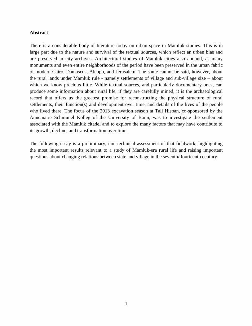
Field C – Figs. 9-11
While not excavated in 2013, Field C (the western slope of the tell) was the first part of
the site to have produced remains of the Mamluk village, and thus makes for us an important
reference point for building construction and spatial organization. This field, which faces the
Wadi Majar, was a target of excavations in the 1970s.26
Those excavations reached bedrock
(identifying several foundation trenches for walls, and thus dating original construction, in the
process), but without broad exposures that would allow for reconstruction of complete building
or street plans.27
Nonetheless, portions of at least three significant building complexes of the
Mamluk period were uncovered during this fieldwork. They seem to be part of a larger area of
settlement that covered the entire slope, up to the Citadel wall itself, and were built against one
another, with shared or abutting walls (some preserved to a height of 9-10 courses), and shared
courtyards. These farmhouses of the 13 and 14th
centuries are of the same construction as the
series of vaulted chambers on the north slope and the Governor’s residential complex in the
Citadel: barrel-vaulted structures supported on walls one meter wide or more and constructed
with faces of roughly cut or reused limestone blocks and rubble fill. The houses are oriented
roughly northwest-southeast, crossing the slope. Because the buildings were not excavated in
their entirety, it is not always clear where the doors were, however those that were uncovered
took the form of high arched doorways and apparently faced cisterns. All of the houses on the
upper and mid-slope were abandoned by the end of the 14th
century.
Two of these structures could be traced with some detail. They are large houses, with
both plastered and beaten earth floors, hearths, and numerous pits (for garbage disposal) and
make use of water channels, cisterns, and sumps built constructed in an earlier period (mostly
Byzantine). The structures produced rich deposits of pottery, glass, and metal objects (of the
same nature as those excavated in Field M), but the rooms in this field are undoubtedly domestic.
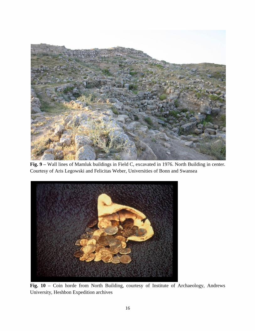
The “North Building” in squares 4 and 6, located mid-slope, was particularly well preserved. It
had two doors (one blocked in a second phase of use), the window sills and thresholds were still
in place, and it preserved a plastered bench in one corner of a room. Plastered into this bench was
a 13th
-century lamp with a cache of 66 silver dirhams dated to the reign of Sultan Baybars (Fig.
10). It was a single-room structure, more than eight meters long (its width is unknown).
26
The last preliminary report on this work was Parker, “Area C”, where one can also find citations to the earlier
published reports by Andrews University. 27
The earlier excavations in this field were meant to produce a trench that would be a stratigraphic guide for the
whole site (vertical coverage), not to document floor plans (horizontal exposure), which is a primary goal for current
fieldwork. The goals for the two phases excavations are quite different but complement one another. While the
earlier excavations provided a deep history of occupation, the current ones give a more detailed picture of a single
period of occupation.
16
Fig. 9 – Wall lines of Mamluk buildings in Field C, excavated in 1976. North Building in center.
Courtesy of Aris Legowski and Felicitas Weber, Universities of Bonn and Swansea
Fig. 10 – Coin horde from North Building, courtesy of Institute of Archaeology, Andrews
University, Heshbon Expedition archives

17
The second structure – a large building more than 8.5x7 meters in size - was located on
the upper slope in squares 9 and 10, not far from the outer face of the Citadel wall. It had at least
three rooms, the largest of which was some seven meters wide and the one to the south of it c. 2-
3 meters on each side. There were multiple doors, some to external courtyards and cisterns.
To the north of these structures three other buildings of the Mamluk period were
uncovered during the 2004 and 2007 field seasons. The best preserved of all the Mamluk-era
village buildings was the farmhouse located in squares 101-103 (Fig. 11). It reused the structure
of a Byzantine-period house and followed the same construction as the North Building: high
arched doorway, high walls, barrel vaults, plastered floors (and possibly walls), a single room (c.
7 meters wide). Like the North Building, it was also altered and rebuilt later in the 14th
century,
as the central room was divided into two by a wall, and an extension was added to the west. The
building is laid out east-west, on an outcrop at the bottom of the tell overlooking the Wadi Majar,
and opens onto an open courtyard with cistern to the south. From the house was recovered a rich
assemblage of imported ceramics, local cooking wares (recovered from the hearth in which they
were used), glass, and metal. The building was abandoned sometime in the late 14th
century, and
was reused as a farmhouse sometime in the later Ottoman era.
Two other smaller buildings were excavated in 2007 from the northern end of the upper
western slope. They are oriented north-south, their walls are preserved for multiple courses, and
they resemble the structures on the north slope: narrow, low-slung barrel vaults, no evidence of
habitation. They may have been used as storerooms, as from them were retrieved a variety of
storage vessels (including sugar molasses jars). There was evidence of a conflagration in one of
the rooms, with fragments of spear points and crossbow bolts melted onto broken jars.
Fig. 11 – Mamluk farmhouse in Field O, 2004 field season, author’s photo

18
Field O – Figs. 12-13
The southwestern slopes of the tell and the flatlands below were designated in 2004
“Field O”. Excavations that season uncovered a large (c. 8x6 meter), single-room farmhouse of
the same construction and layout as those described above. It was oriented east-west, with its
door facing animal pens to the south. In a later phase of occupation, the room was divided into
two by a wall and a qiwarah (grain storage bin) built into that wall in a corner of the room. The
walls were preserved to a height of as many as ten courses; the doorway, lintel, and threshold
were still in place; and remnants of floor plaster remained. The courtyard outside was divided
into two halves, which, according to ethnographic accounts, may have been a way to separate
two kinds of livestock from one another (sheep and goats from donkeys, for example).
Foundation trenches were not reached, so it is not clear when the building was originally
constructed. It could be Mamluk in construction, with reuse in the Late Ottoman period (19th
century).
Fig. 12 – Mamluk farmhouse in O.9/10, 2013 field season. Note remnant of heavily plastered
floor in upper left corner. Photo and floor plan courtesy of Qutaiba Dasouqi, Jordanian
Department of Antiquities
In 2007 excavation of this field continued to the northeast, where the earth surface
suggested the presence of numerous walls, vaults, and cisterns. The short field season that year
identified the presence of two adjacent houses of the same construction as described here.
Excavation of those structures resumed in 2013 and confirmed important characteristics of the
Mamluk-era occupation. The houses were oriented north-south, on a saddle below the tell, and
they shared walls (they were built against one another, without connecting doorways). On the
west side was a courtyard, and to the north and east appear to be cisterns. The living space of
these single-room complexes is approximately 5x8 meters. The floors and walls were heavily
plastered (and replastered many times – Fig. 12). Each of the houses produced large quantities of
pottery, glass, metal, and lithics. While the foundation trenches of the walls have not yet been

19
reached, occupation of the houses can be securely dated to the 14th century. There is, as well,
evidence for continued occupation beyond that. The structures, like the one excavated in 2004,
may have been reoccupied in the 19th
century, as objects from this period (including storage jars
and chubouk/tobacco pipe bowls) were recovered from later strata. These buildings, unlike others
excavated in previous years, were not as well preserved (Fig. 13).
Fig. 13 – Mamluk farmhouse in O.5/7, 2013 field season. Courtesy of Aris Legowski and
Felicitas Weber, Universities of Bonn and Swansea
Field B – Fig. 14 and 15
Occupation on the south slope of the tell is less known for this period. The Heshbon
Expedition spent considerable efforts clearing the Iron Age reservoir in the 1970s and
documenting the complicated stratigraphy of the access route to the summit of the tell from the
south (Field D). Little of anything “Middle Islamic” in date was identified on the south slope,
outside of evidence for terracing: after the abandonment of the Citadel in the later 14th
century,
the southern gateway and its staircase were covered with soil and transformed into a garden or
orchard.

20
In 2011 excavation resumed at this part of the site, initially to continue excavation of the
reservoir and clarify its connecting water systems. Fieldwork that year exposed three plastered
floors of the Mamluk period, located above and on the southern end of the reservoir (Field B,
square 4). Excavation in the area continued in 2013, moving to the south, and revealed a
Byzantine-era house. At the end of the Mamluk period (late 15th
or 16th
century CE), this room
was used as a garbage pit. (The contents of that pit are now in labs for analysis.)
The southern slope has a very different history of use from that of the north and west,
which may be related to its location to the road system and the continued use of this space as an
access corridor to the summit of the tell. It is possible that the southern slopes were never
occupied in the Mamluk period, as this was the ceremonial entrance to the Citadel, and that only
with the abandonment of the Citadel was the area converted to agricultural and refuse use, as was
the case on the summit of the tell. However, the architectural remains on the southern slope are
right below topsoil, and it is possible that there has been extensive removal of standing walls for
building material in the modern village, as attested during ethnographic interviews.
Fig. 14 – Pits in floor of Byzantine building in B.4., 2013 season. Stone-lined pit in lower left
corner is Late Mamluk in date. Courtesy of Aris Legowski and Felicitas Weber, Universities of
Bonn and Swansea

21
Fig. 15 – Handmade jars found in Late Mamluk contexts in B.4 pit, 2013 season (left) and Field
M, 2007 season (right). Photo on left courtesy of Aris Legowski and Felicitas Weber,
Universities of Bonn and Swansea; photo on right of Institute of Archaeology, Andrews
University
Field R
Field R lies on the eastern slope of the tell, an area that served as the Heshbon
Expedition’s sifting station (and excavation dump) during the 1960s and 1970s. Because of the
heavy, contemporary overburden that this produced, this part of the site was not the subject of
serious archaeological investigation until recent years. The study of the southeast and north east
corner towers of the Citadel were the primary reason for turning attention to the east slope. In
2012 excavation began on the upper slope, adjacent to the mid-section of the Citadel wall, in a
renewed effort to locate a foundation trench for the acropolis wall. Efforts continued this season,
resulting in the identification of a series of walls close to the outer face of the Citadel wall,
dating to the Mamluk period. Their function is not clear at this point. No floor was reached in the
southern end of the squares excavated this season, however the northern end, excavated to
bedrock, revealed that the bedrock had been shaped to form some kind of foundation for the
acropolis wall. There were also many Mamluk pottery sherds found on the bedrock, suggesting
that the bedrock had been visible during this period. The entire Citadel wall, down to foundation
level, may have been visible, at least in sections, on this side of the tell, and this accessibility
may be connected to the use of the cavernous chambers lying under the southeast corner tower.28
The appearance and use of the eastern slope during the Mamluk period is only now beginning to
be investigated and nothing more conclusive can be offered at this point in the fieldwork.
28
These chambers were explored in 2010. On passage leads directly from a cave below the northeast tower of the
Citadel, underground to the surface, some 100 feet outside the Citadel to the southeast. On the basis of ceramic
collection done from the interior of the passageway, the last phase of use was the Mamluk period. Although
excavation inside that tower has not yet reached its foundations, it is possible that access to the passage was from the
tower itself, and that this may have served as an exit route from the Citadel during the 14th
century CE.
22
Spolia project
A spolia project was reinstituted this season, primarily in order to identify and map
architectural elements from the Citadel dating from the Mamluk period, which were reused in the
building of the modern village. While spolia documentation was included in earlier seasons of
the Phase II project, those efforts were restricted to the tell itself and were intended to locate
columns, capitals, and bases from the Roman temple and Byzantine church reused in other
constructions, for the purposes of reconstruction and site presentation. This season the
documentation was extended for the first time to the modern village of Ḥisbān and the caves
located within it.29
The Mamluk Citadel, as it stands today, has no identifiable inscriptional or
emblazed plaques or registers, or any kind of architectural decorative devices. In order to
determine whether this stark form of military architecture was typical of rural outposts, a search
for spolia was put into place this season. The documentation, a long-term project, will ultimately
serve three purposes: 1. To locate architectural remains of the Mamluk Citadel removed from the
summit, 2; to study the changing contours of the village over time; and 3. to study of “making of
memory” – to learn how the Mamluk period is remembered by residents of the modern village
and to what degree historical narratives associated with it have been incorporated into their
communal identity or ties to “place”. (This latter objective would be accomplished in
conjunction with ethnographic study). The survey this season did not locate recognizable
Mamluk spolia, although it did identify 47 architectural members of classical and Late Antique
date. A protocol for documentation and GIS mapping was developed this season which will
allow integration into the larger excavation’s Filemaker database system.30
Agriculture, water management, and the environment
It was a priority this season to implement a comprehensive plan of environmental
research to investigate the changes in land use, water systems, and climate that may have
triggered the fluctuations in settlement intensity documented in the archaeological record. To this
end, a zooarchaeologist (animal bone specialist), phytolith specialist (analyst of calcified plant
remains), and archaeobotanist (seed specialist) worked closely together in sampling and
interpretation. This coming year soil samples will also be sent to a palynologist (pollen
specialist) and geomorphologist (specialist on soil formation and erosion) as part of the larger
study on climate change.31
This was a particularly propitious year for this kind of analysis, as
excavation throughout the site produced Mamluk-era floors (primary use - living space and locus
29
Regional surveys in the Ḥisbān hinterland conducted in the 1970s, and more recently, have produced no evidence
of Mamluk spolia, though they have produced extensive evidence of Mamluk-era settlement and land use for miles
beyond the tell (Ibach, Archaeological Survey of the Hesban Region; Christopherson, “Random Survey and
Settlement Patterns”). These surveys, however, did not cover the modern village. 30
The spolia survey was conducted this season by Dr. Daniel Redlinger of the University of Bonn, who submitted a
preliminary report on which the data for this summary is based. Plans are in place to expand it next season, in
collaboration with the cave laser mapping project. 31
The labs are in Texas (phytolith), Nebraska (pollen), Gronigen (seeds), and Erlangen (soil genesis -
geomorphology).
23
of food preparation) and pits (secondary use - trash disposal) – the ideal contexts for the study of
agricultural systems, animal husbandry, and general food preparation and diet.
The analysis of animal bones this season began with the contents of the storeroom of the
Mamluk Governor’s residence (excavated in previous seasons), and next year will be extended to
the contents of the houses excavated this season.32
The fill above the floors of two rooms of the
storeroom were rich in zooarchaeological remains and yielded important preliminary results. The
quality of the meat consumed in the garrison was of great quantity and of the highest quality: the
best cuts of meat (the hind quarters and axial skeletons of sheep and goats, for example) and was
quite varied. The garrison consumed not only domestic sheep, goat, chicken, geese, and horse,
but also wild game: gazelle – of at least three species, boar, rabbit, and exotic fish (parrotfish
from the Red Sea).33
All meat was brought to the Citadel in processed form and was freshly cut
(the meat was quite fresh when consumed): butchery was done elsewhere and by professional
butchers (as indicated by the quality of execution of the cut marks). The storeroom, at least in its
last phase of use (mid-14th
century), was clearly used as a midden, for the disposal of dining
scraps, and not cleaned out. Next year, when the remains of the houses excavated in 2013 have
been analyzed, we will be able to compare the diets of the garrison and the village and possibly
describe patterns of meat acquisition, sharing, and distribution within the village.
Phytolith analysis was incorporated into the excavations in 2010 and continued this
season. As the calcified remains of plants, phytoliths (which have an excellent record for
recovery in Jordan) preserve information on the kinds of plants cultivated for both human
consumption and animal fodder. They also provide indirect evidence of historical climatic
conditions. Laboratory analysis by the phytolith specialist in previous seasons indicated that
wheat and barley production during the medieval Islamic periods at Ḥisbān peaked under the
Mamluks. Moreover, on-going analysis has identified irrigation signals in the phytoliths
extracted from soils on the Citadel storeroom floor (from the same context as the bones studied
this season).34
This evidence suggests that grain production, which was normally rain-fed in this
part of Bilād al-Shām, was, for a brief period of time in the 14th
century, irrigated – an action that
requires coordinated labor and an influx of funds and was meant to guarantee dependable
revenues in a region known for irregular yields (the result of heavy fluctuations in rainfall).35
In
32
Published reports on the zooarchaeological remains (Mamluk contexts) from the Hesban Expedition can be found
in von den Driesch and Boessneck, “Final Report on the Zooarchaeological Investigation” and Brown, “Middle
Islamic Faunal Distributions”. 33
There was only one sample of wild boar. It is not clear at this point whether it was merely hunted or actually
consumed, as there were no cut marks on the bone. The horse remains (including a humerus of an animal over the
age of 18 months) were probably eaten, as they did bear butchers marks. Notably, the remains of wild game (ostrich,
gazelle) were also recovered from houses of the Mamluk-era village, excavated in the 1970s (Parker, “Area C”).
Either hunting game was not necessarily a Mamluk privilege (or it was not enforced), or wild game was distributed
as a meat product throughout the village. 34
Laparidou, “Identifying changing agricultural economies”. 35
In a country like Jordan, which is today the fifth most water-starved country in the world, water capture, storage,
distribution, and use are the key to agricultural productivity and the survival of many communities located in areas
of lowest rainfall. In recent times, the wheat harvest has failed one out of every five years (Palmer, “Following the
Plow”, 132).The Madaba Plains lies on the 300 mm isohyet, which is sufficient for rain-fed agriculture. The annual

24
short, it may indicate direct state investment in grain production for the period that the Citadel
housed the garrison.36
While state involvement in irrigation was commonplace in Mamluk Egypt,
it was essentially unheard of for the rain-fed grain fields of Syria. Irrigation in Syria, we have
come to believe, was limited to gardens and orchards, both urban and rural.
Unfortunately, in over forty years of excavation and survey at Tall Ḥisbān, no purely
archaeological evidence for irrigation has been identified: no irrigation canals or aqueducts for
the transportation of water to fields. The site does have, however, a massive reservoir – a large
moat-shaped cut at the base of the tell on its south side that was used for some kind of water use
in the Iron Age (Fig. 16).37
The Citadel also sits on top of a complex of interconnected caves and
their passages, as do the slopes and flatlands where the historical village was located. While cave
systems are characteristic of Jordan as a whole, they are particularly extensive at Ḥisbān. The
changing functions of the vast system of subterranean chambers – natural openings in the soft
limestone modified by human hands for various purposes over the millennia – are not fully
understood. In an effort to more systematically explore the potential relationship between the
reservoir and the cave system under and surrounding the tell, excavations this year included
carefully cleaning and photo documentation of the reservoir, sampling of the plaster covering its
surfaces and feeding channels (to date last phase of use), and preliminary mapping and drawing
of the cave system adjacent to the reservoir, dubbed the “Abu Nur” cave by the excavation team.
rainfall there is irregular, however, and for the latter part of the Mamluk period, there were years of drought in the
region, a historical fact confirmed by environmental proxy data. 36
Such investment would also coincide with the use of the Citadel as a redistribution point for sugar molasses,
another agricultural activity at Ḥisbān that seems to have been under state control. Dozens of cane sugar molasses
jars were covered from the Citadel storerooms in 1998 and 2001. It was the highest concentration of such storage
jars from any excavated context in Syria to date, indicating a large storage capacity, with high potential revenues
(Walker, “Sowing the Seeds”, 190-191 – revenues here, however, based on raw cane sugar). All the more
remarkable, was that surveys in the region around Ḥisbān have revealed no sugar mills; the nearest sugar plantations
of the period were located in the Jordan Valley. 37
The reservoir below the tall appears to have been first used as a quarry, as have been many of the caves around the
tell, for the acquisition of building material. In the Iron II period it was refashioned as a reservoir, according to the
original excavators, plastered, and fed by winter rain waters. With an estimated holding capacity of over two million
liters, it is impossible that the reservoir was ever filled by seasonal rains. More likely is that it was filled by an
aqueduct, fed in turn by local springs. There is, however, no evidence anywhere in the region for an aqueduct, of any
period. The reservoir went out of use in the Persian period and filled with rubble removed from the summit of the
tell. It is unclear what function it had, if any, in the Mamluk period.

25
Fig. 16 – View of reservoir, from north, courtesy of Aris Legowski and Felicitas Weber,
Universities of Bonn and Swansea. Note access to the Abu Nur cave in background.
The function of the Abu Nur cave has changed many times over the centuries. Used
originally as a quarry and then monumental cistern (constructed in the Hellenistic period), it
continued to function for water storage under Byzantine rule, only gradually going out of use as
a multi-chamber cistern and possibly used domestically during the Early Islamic period. In the
19th
century CE it was transformed for stabling for animals (sheep and goats). Preliminary
investigation of the Abu Nur cave in 2010 and 2013 suggest that much of this subterranean
system was used as a large midden (town dump) in the Mamluk period, parts of the water system
having gone out of use by then. However, at least one chamber, with connecting passages, was
retained for water storage (as large water jars were retrieved from the bottom of one cistern –
Fig. 17). Soil samples taken for geomorphological analysis in 2010 indicated that, at one point in
its history, water channeled through the interconnecting passageways in this cave system at some
speed, possibly suggesting that the system functioned as a qanat (a kind of underground
aqueduct).38
The confirmation this season of a direct passage from the Abu Nur cave to the tell’s
38
We thank Prof. Bernhard Lucke, University of Erlangen, for this very preliminary suggestion. Qanats have been
identified elsewhere in Jordan, but they are most clustered in the Decapolis region of the North and date to the
Roman period. Such systems are known to have been reused in the Byzantine and Umayyad eras in southern Syria
(Lightfoot, “Qanats in the Levant”).

26
reservoir would seem to strengthen such an argument. Further investigation of this and other
water systems in the environs will be a priority in the next field season.
Fig. 17 – Southernmost cistern in Abu Nur cave, in use in Mamluk period. Courtesy Prof. David
Byers Utah State University.
V. Conclusions
How do we make sense of the statement by Ibn Qāḍī Šuhba that “it [Amman] was settled
(sukinat), and he [Amir al-Āqūš al-Ǧunkandārī, Governor of Amman] transferred here the qāḍī
and people of the market of Ḥisbān (ahl sūq Ḥisbān) and a group of them (wa-ǧamāʿa minhum)
from the area. And it became the heart of the region (umm al-balad), as it was formerly”?39
Forced population transfers, a tactic well known for the Ottomans, may have been used by the
Mamluks, as well, but for different purpose. In the Transjordan, it was used to rebuild the town
39
Ibn Qāḍī Šuhba, Tārīḫ 1:550.

27
of Ajlun, after the destruction wrought by flooding in 728/1328.40
If what Ibn Qāḍī Šuhba is
describing is indeed population transfer, it would seem that it was employed for similar
economic purpose in Amman, as well. Is there evidence “on the ground” for an emptying out of
the town of Ḥisbān in 757/1356, the date of this entry in Ibn Qāḍī Šuhba’s narrative? What do
such actions look like archaeologically?
It is too early to say with confidence whether the town at Ḥisbān was likewise “planned”,
created through imperial fiat and through direct investment and population transfer, or that it
suffered sudden population decline as a result of the same state actions. However, its rapid
growth from a village (which was textually invisible for several centuries) to a densely settled
town would not have happened organically, likewise its large-scale abandonment in the 15th
century. The results of the excavations to date suggest some level of spatial planning along the
north slope and on the upper west slope, with dense occupation and judicious use of space for
storage. The upper slopes, those nearest to and adjacent to the Citadel walls, were abandoned –
suddenly and completely – by the end of the 14th
century. The architecture, pottery, and coin
evidence confirm this. Settlement, however, seems to have continued further downslope and
away from the Citadel, in stand-alone farmhouses, which had their own animal pens, cisterns,
and storage facilities. These, too, were eventually abandoned (at least for year-round
occupation), but they were reoccupied and rebuilt as farmhouses later in the Ottoman period. In
short, there may have been two “Ḥisbāns” – the one a state creation (and in service of the
Citadel), the other indigenous, self-sufficient, and resilient.
The history of water use at the site may be key to understanding the cycles of
intensification and abatement in settlement. Changes in land management (such as the shift from
irrigation to dry-farming, and from export market crops to a diversified, more sustainable, and
less intensive, regime), which is implied by documentary sources (waqfiyyāt and tax registers),
may have been a critical component in the history of “mega-villages” such as Ḥisbān that grew
and collapsed suddenly over the course of Mamluk rule.41
The struggle for control of land and
water would have been a focal point in the relations between state and rural society in this
period, and it is one factor that merits more attention from Mamlukists.
On the issue of the reason for settlement abandonment, the archaeological record is
suggestive, though ambiguous. On other matters, archaeological data seems to be absent – or we
have been unable to identify it. We do not know, for example, the full physical extent of the
town/village in the Mamluk period and can make no estimates, yet, of population size. We do not
know where the residents of Hisban in this period were buried.42
Most importantly, we cannot
40
On the rebuilding of Ajlun following this disaster, see Walker, Jordan in the Late Middle Ages, 144, 210, 230. 41
On these changes in agriculture in the Transjordan during the transition to Ottoman rule, see Walker, “Regional
Market and their Impact on Agriculture”, and ibid, Jordan in the Late Middle Ages, 233-271. 42
The cemetery excavated in the Citadel storeroom in 2001 was Ottoman in date (Walker, “Late Ottoman
Cemetery”), and this author suspects that the many references in the 1970s excavation reports to Mamluk-era cist
graves (for individual burials) found in cistern mouths, and similar installations, may be contemporary to this. As for
the location of the Roman and Byzantine cemeteries, these were located in rock-cut installations (many in caves)
across the Wadi Majar (Waterhouse, Necropolis of Hesban). On-going ethnographic work has suggested that the
modern village sits atop an ancient cemetery.

28
say how typical Ḥisbān was as a village (and then town). Although textual and epigraphic data
suggest that as an administrative center (or a low-level district capital, wilāyah), it may be
representative of the frontier regions, how the settlement itself compared to others in Syria and
Egypt can only be determined through systematic comparison with other excavated settlements.43
Future field season at Tall Ḥisbān will certainly aim to address these questions. The most
pressing issues are, however, the structure of the village, the character and extent of its water
systems, and the nature of indigenous agriculture during the Mamluk period. This will require an
expansive study of the standing architecture, excavating as wide an area as possible to document
village layout, organization of streets and access to shared facilities (such as cisterns, threshing
floors, and storage facilities), and excavating to the depth of wall foundation trenches (to date
original construction and document building development). This will be done in close
collaboration with other excavations of Mamluk-era villages, such as Tall Jalul (Madaba Plains,
Jordan)44
, Dhibān (southern, central Jordan), Khirbat Birzeit (Palestine)45
, and Bayit Vegan
(Israel)46
. Tall Ḥisbān offers Mamlukists a rare opportunity to physically examine extant water
systems and to study modes of local agriculture. To this end, a full documentation of the exposed
water systems (water channels, cisterns, sumps) will begin in 2014. Given the strong possibility
that the cave systems were always the heart of water storage, and possibly irrigation, at this site,
we plan laser mapping of the caves and passages in the immediate vicinity of the tell, along with
sampling of soils from these systems as part of a larger geomorphological study. The extensive
retrieval of metal and stone agricultural implements from the excavated farmhouses and storage
buildings presents a rich opportunity to study indigenous technologies of agriculture. Analysis of
the organization and technology of Mamluk agriculture must rely on a combined analysis of
these tools and the soils and the plant remains they preserve, along with the further development
of low-flying aerial photography (to identify ancient fields and terraces and water canals) and
systematic study of Mamluk-era agricultural manuals (in progress by the author).
It is possible now, for perhaps the first time, to write a history of Mamluk-era rural
societies. This can be accomplished only through a real partnership between “text and tell”, and
through well-integrated multidisciplinary investigation of individual settlements. The
archaeological record offers tangible possibilities for the study of the family and gender.
Through the study of physical houses, their relationship with one another, their contents and
spatial patterning, the Mamluk-era household can be reconstructed. This is, in essence, a micro-
history approach to Mamluk studies. Village life (and family life) under the Mamluks will not be
invisible for much longer, nor the villager mute.
43
The status of low-ranking district capitals and their possible relationship with outlying settlements may be
assessed through a combined reading of administrative manuals and inscriptions from garrison buildings. For an
example of this approach, using inscribed table wares from the Ḥisbān Citadel storerooms, see Walker, “The
Phenomenon of the Small Rural Citadel”. 44
al-Shqour, “Islamic Village at Tall Jalul”. The excavations are on-going. 45
These excavations have been under the direction of Prof. Hamed Salem, Birzeit University. 46
This began as a salvage project in 2012 by the Israel Archaeological Authority and under the direction of Dr.
Benjamin Dolinka. Published reports are forthcoming.

29
Literature
Primary sources – textual
Ibn Qāḍī Šuhba, Tāqī al-Dīn (d. 851/1448), Tārīḫ Ibn Qāḍī Šuhba, ed. Adnan Darwish,
Damascus: L’Institut Français du Proche Orient 1997.
Primary sources – Archaeological and specialists’ reports
Baramki, Demetri, “al-Nuqūš al-ʿarabiyya fī l-bādiya al-sūriyya”. al-Abḥāṯ 17.3 (1963), pp. 339-
461.
Bird, Phyllis, “Heshbon 1968: area D," in “Andrews University Heshbon expedition: the first
campaign at Tell Hesban (1968)," Roger Boraas and Siegfred Horn, eds., Andrews
University Seminary Studies 7 (1969), pp. 97-239.
Brown, Robin, “Middle Islamic Faunal Distributions in the Southern Highlands of Transjordan:
Regional and Historical Perspectives on Animal Representations and Roles,” in: The
Materiality of the Islamic Rural World, ed. Stephen McPhillips and Paul Wordworth,
Philadelphia: University of Pennsylvania Press, 2013, in print.
Christopherson, Gary, “A Regional Approach to Archaeology on the Madaba Plains: Random
Survey and Settlement Patterns,” web-published conference paper, Annual Meetings of the
American Schools of Oriental Research, 1997, (available on-line at:
http://www.casa.arizona.edu/MPP/hrs1_report/hrs1.html)
Ibach, Robert, Hesban 5. Archaeological Survey of the Hesban Region: Catalogue of Sites and
Characterizations of Periods, Berrien Springs, Andrews University Press, 1988.
al-Jbour, Khaled Suleman, “Étude des inscriptions arabes dans le désert nord-est de la Jordanie.”
Unpublished Ph.D. dissertation, Université de Provence 2006.
________, “Bayyān asʿār al-ḥinṭa fī naqsh mamlūkī min al-bādiyya al-urduniyya fī ʿāmay 757
H/1347 M wa 764 H/1363 M.” Journal for History and Archaeology 5/4 (2011), pp. 1-18.
Jones, Ian W.N. Jones, Thomas E. Levy, and Mohammad Najjar, “Khirbat Nuqayb al-Asaymir
and Middle Islamic Metallurgy in Faynan: Surveys of Wadi al-Ghuwayb and Wadi al-Jariya
in Faynan, Southern Jordan,” Bulletin of the American Schools of Oriental Research 386/1
(2012), pp. 67-102.
Kareem, J.M.H., The Settlement Patterns in the Jordan Valley in the Mid- to Late Islamic
Period, Oxford: British Archaeological Reports 2000.
LaBianca, Øystein S. and Bethany J. Walker, ed., Hesban 14. Hesban and Global History:
Findings of Phase II and Conclusions Regarding the Significance of the Hesban Project for

30
our Understanding of Global History, Berrien Springs, MI: Andrews University Press
(forthcoming).
Laparidou, Sofia, “Identifying changing agricultural economies as key factors of settlement
shifts in medieval Islamic Jordan: a phytolith analysis approach,” in: Proceedings of the
Eighth International Conference on the Archaeology of the Ancient Near East, ed. Alison
Gascoigne, Wiesbaden: Harrassowitz 2013, in print.
Parker, Thomas, S., “Area C.4, 6, 8, 9, 10,” in: “Heshbon 1976: The Fifth Campaign at Tell
Heṣbân (1976) A Preliminary Report,” eds. Roger S. Boraas and Larry T. Geraty, Andrews
University Seminary Studies 16/1 (1978), pp. 71-107.
Politis, Konstantinos D., Archaeological Landscapes of Zoara: Results of the Survey and
Excavations in the Ghor es-Safi (Jordan) from 1997 to 2010, London: Palestine Exploration
Fund Monograph X (forthcoming).
al-Salameen and Hani al-Falahat,“Jabal Haroun During the Islamic Period: a Study in the Light
of Newly Discovered Inscriptions”. Arabian Archaeology and Epigraphy 18 (2007): 258-64.
al-Salameen, Zeyad, Hani Falahat, Salameh Naimat, and Fawzi Abudanh,“New Arabic-Christian
Inscriptions from Udhruḥ, Southern Jordan”. Arabian Archaeology and Epigraphy 22.2
(2011): 232-42.
von den Driesch, Angela and Joachim Boessneck, “Final Report on the Zooarchaeological
Investigation of Animal Bones Finds from Tell Hesban, Jordan,” in: Hesban 13. Faunal
Remains: Taphonomical and Zooarchaeological Studies of the Animal Remains form Tell
Hesban and Vicinity, ed. Øystein S. Labianca and Angela von den Driesch, Berrign Springs,
MI: Andrews University Press 1995, pp. 65-108.
Walker, Bethany J., “The Islamic Age,” in: Hesban 11: The Pottery, ed. Larry Herr, Berrien
Springs, MI: Andrews University Press 2012, pp. 507-594.
______, Hesban 9. The Islamic Strata: A Study of the Stratigraphy of Tell Hesban from the
Seventh through the Fifteenth Centuries A.D., Berrien Springs, MI: Andrews University
Press (forthcoming).
Walker, Bethany J. and Øystein S. LaBianca, “The Islamic Qusur of Tall Hisban: Preliminary
Report on the 1998 and 2001 Seasons,” Annual of the Department of Antiquities of Jordan
47 (2003), pp. 443-471.
_______, “Tall Hisban,” in: “Archaeology in Jordan, 2010 and 2011 Seasons, ed. Donald R.
Keller, Barbara A. Porter, and Christopher A. Tuttle, American Journal of Archaeology
116/4 (2012), pp. 716-717.
_______, “Tall Hisban,” in: “Archaeology in Jordan, 2007 Season”, ed. Stephen H. Savage,
Donald R. Keller and Christopher A. Tuttle, American Journal of Archaeology 112/3
(2008): 509-528.

31
_______, “Tall Hisban, 2004,” American Journal of Archaeology 109.3 (2005): 536-539.
_______, “Tall Hisban, 2004 – An Investigation in Medieval Rural History”, Newsletter of the
American Center of Oriental Research 16/2 (2004), pp. 1-3.
_______, “Countering the Urban Bias in Islamic Studies: Final Report on MPP2001: Tall
Hisban, Jordan, Newsletter of the American Center of Oriental Research 13/1 (2001), pp. 3-
4.
Secondary sources
Abu Ghāzī, ʿImād Badr al-Dīn, Taṭawwur al-Ḥiyāzah al-Zirāʿīyah fī Miṣr Zamān al-Mamālīk al-
Jarākisah. Cairo: ʿAyn li-Dirāsāt wa al-Buḥūth al-Insāniyyah wa al-Ijtimāʿiyyah, 2000.
Abu Mustafa, Ayman, The Trade Routes in Palestine during the Mamluk Period (1260-1516
A.D.): a historical, geographical and economic study, Birzeit: Birzeit University 2006.
Antrim, Zayde G., Routes and Realms: The Power of Place in the Early Islamic World, Oxford:
Oxford University Press 2012.
‘Athāminah, Khalīl. Filisṭīn fi al-‘Ahdayn al-Ayyūbī wa al-Mamlūkī (1187-1516), Beirut:
Mu’assisah al-Dirasat al-Filisṭīniyyah 2006.
Borsch, Stuart, “Environment and Population: The Collapse of Large Irrigation Systems
Reconsidered,” Comparative Studies in Society and History 46/3 (2004), pp. 451-468.
Cytryn-Silverman, Katia, The Road Inns (Khans) in Bilad al-Sham. Oxford: British
Archaeological Reports 2010.
Franz, Kurt, “The Ayyubid and Mamluk Revaluation of the Hinterland and Western Historical
Cartography,” Mamluk Studies Review 12/2 (2008), pp. 133–158.
_______, Atlas der Beduinen unter dem Sultanat 564–734/1169–1334. Beduinische Gruppen in
mittelislamischer Zeit II, Wiesbaden, (forthcoming).
Frenkel, Yehoshua, “Agriculture, Land-Tenure and Peasants in Palestine During the Mamluk
Period,” in: Egypt and Syria in the Fatimid, Ayyubid and Mamluk Eras, ed. Urbain
Vermeulen and Jo van Steenberge,. Leuven: Uitgeuerij Oeeters 2001, pp. 193-208.
_______, The management of water in fourteenth century Damascus. Unpublished conference
paper, University of Ghent, June 2011.
Garçin, Jean-Claude, Un centre musulman de la Haute-Égypte médiévale: Qus. Cairo: Institut
Français d’Archéologie Orientale 1974.
Ghawanmah, Yūsūf, Tarīkh Sharqi al-Urdunn fi ʿAṣr Dawlat al-Mamālīk al-Ulā (al-Qism al-
Ḥaḍarī). Amman: Wizārat al-Thaqāfah wa al-Shabāb, 1979.

32
_______, “al-Qarya fī Junūb al-Shām (al-Urdunn wa Filisṭīn) fī al-ʿAṣr al-Mamlūkī fī Dawʾ
Waqfiyyat Ᾱdar,” Studies in the History and Archaeology of Jordan 1 (1982), pp. 363-371.
Grabar, Oleg, “A small episode of early Abbasid times and some consequences," Eretz-Israel 7
(1964), pp. 44*-47*.
Guo, Li Commerce, Culture, and Community in a Red Sea Port in the Thirteenth Century: the
Arabic Documents of Quseir, Leiden: Brill 2004.
Levanoni, Amalia, “Food and Cooking during the Mamluk Era: Social and Political
Implications,” Mamluk Studies Review 9/1 (2005), pp. 1-22.
________, “Water Supply in Medieval Middle Eastern Cities: The Case of Cairo,” Al-Masāq
20/2 (2008), pp. 179-205.
Lewicka, Paulina, Food and Foodways of Medieval Cairenes: Aspects of Life in an Islamic
Metropolis of the Eastern Mediterranean, Leiden: Brill 2011.
Lightfoot, Dale R., “Qanats in the Levant: Hydraulic Technology at the Periphery of Early
Empires,” Technology and Culture 38/2 (1997), pp. 432-451.
Maqablah, Ayman Ahmad Hussein, “al-Qaryah fī Bilād al-Shām fī al-ʿAṣr al-Mamlūkī,”
Unpublished M.A. thesis University of Yarmouk, 1998.
McQuitty, Alison, “Khirbat Faris: Vernacular Architecture on the Kerak Plateau, Jordan,”
Mamluk Studies Review 11/1 (2007), pp. 157-71.
Milwright, Marcus, Fortress of the Raven: Karak in the Middle Islamic Period (1100-1650),
Leiden: Brill 2008.
Mukahalah, Noha Muḥammad Ḥussein, “al-Zirāʿah fī Bilād al-Shām fī al-ʿAṣr al-Mamlūkī,”
Unpublished M.A. thesis, University of Yarmouk, 1992.
Ouerfelli, Mohamed, Le sucre: Production, commercialization et usages dans la Méditerranée
médiévale, Leiden: Brill 2008.
Palmer, Carol, “Following the Plough”: The Agricultural Environment of Northern Jordan,”
Levant 30 (1998), pp. 129-165.
Petry, Carl, Protectors or Praetorians? The Last Mamluk Sultans and Egypt’s Waning as a
Great Power. Albany: SUNY Press 1994.
_______, “Fractionalized Estates in a Centralized Regime: The Holdings of al-Ashraf Qaytbay
and Qansuh al-Ghawri According to their Waqf Deeds,” Journal of the Social and Economic
History of the Orient 411 (1998), pp. 96-117.
_______, “Waqf as an Instrument of Investment in the Mamluk Sultanate: Security or Profit?”
in: Slave Elites in the Middle East and Africa: A Comparative Study, ed. M. Toru and J. E.
Philips, N.Y.: Kegan Paul International 2000, pp. 95-115.

33
Porter, Benjamin, “Locating Middle Islamic Dhiban on the Mamluk imperial periphery,”
Fondation Max van Berchem Bulletin 24 (2010), pp. 5-7.
Rapoport, Yousef, Marriage, Money and Divorce in Medieval Islamic Society, Cambridge:
Cambridge University Press 2005.
Sabra, Adam, Poverty and Charity in Medieval Islam. Cambridge: Cambridge University Press
2000.
________, “The Rise of a New Class? Land Tenure in Fifteenth-Century Egypt: A Review
Article,” Mamluk Studies Review 8/2 (2004), pp. 207-210.
Sato, Tsugitaka, State and Rural Society in Medieval Islam: Sultans, Muqta‘s and Fallahun,
Leiden: Brill 1997.
Shoshan, Boaz, “Mini-Dramas by the Water: On Irrigation Rights and Disputes in Fifteenth-
Century Damascus”, in: Histories of the Middle East: Studies in Middle Eastern Society,
Economy and Law in Honor of A.L. Udovitch, ed. Roxani Eleni Margariti, Leiden: Brill
2011, pp. 233-244.
al-Shqour, Reem, “2008 Excavations at the Islamic Village at Tall Jalul”, Annual of the
Department of Antiquities of Jordan 53 (2009), pp. 35-43.
Strange Burke, Katherine, Archaeological Texts and Contexts on the Red Sea: The Sheikh’s
House at Quseir al-Qadim, unpublished Ph.D dissertation, University of Chicago 2007.
_______, “A Note on Archaeological Evidence for Sugar Production in the Middle Islamic
Periods in Bilad al-Sham,” Mamluk Studies Review 8/2 (2004), pp. 109-118.
Walker, Bethany J. “The Late Ottoman Cemetery in Field L, Tall Hisban”, Bulletin of the
American Schools of Oriental Research 322 (2001), pp. 47-65.
______, “Mamluk Administration of Transjordan: Recent Findings from Tall Hisban”, al-‘Usur
al-Wusta 13/2 (2001), pp. 29-33.
______, “Mamluk Investment in Southern Bilād al-Shām in the Fourteenth Century: The Case of
Ḥisbān,” Journal of Near Eastern Studies 62/3 (2003), pp. 241-261.
______, “Mamluk Investment in the Transjordan: A ‘Boom and Bust’ Economy”, Mamluk
Studies Review 8/2 (2004), pp. 119-147.
______, “Regional Markets and their Impact on Agriculture in Mamluk and Ottoman
Transjordan,” in: On the Fringe of Society: Archaeological and Ethnoarchaeological
Perspectives on Pastoral and Agricultural Societies, ed. Benjamin Saidel and Evelyn van
der Steen Oxford: British Archaeological Reports, 2007, pp. 117-125.
______, “Sowing the Seeds of Rural Decline? Agriculture as an Economic Barometer for Late
Mamluk Jordan”, Mamluk Studies Review 11/1 (2007), pp. 173-199.

34
______, “The Tribal Dimension in Mamluk-Jordanian Relations,” Mamluk Studies Review 13/1
(2009), pp. 82-105.
______, “From Ceramics to Social Theory: Reflections on Mamluk Archaeology Today,”
Mamluk Studies Review 14 (2010), pp. 109-157.
______, Jordan in the Late Middle Ages: Transformation of the Mamluk Frontier, Chicago:
University of Chicago, Middle East Documentation Center Press 2011.
______, “Transjordan as the Mamluk Frontier: Imperial Conceptions of Authority and Space”,
in” La Transgiordania Neu Secoli XII - XIII e le ‘Frontiere' Del Mediterraneo Medievale:
Trans-Jordan in the 12th and 13th Ccnturies and the ‘Frontiers' of the Medieval
Mediterranean, ed. Guido Vannini, Oxford: British Archaeological Reports 2011, pp. 197-
204.
______, “Exercising Power on the Mamluk Frontier: The Phenomenon of the Small Rural
Citadel, Case of Tall Hisban,” in: Proceedings of the Eighth International Conference on the
Archaeology of the Ancient Near East, ed. Alison Gascoigne, Wiesbaden: Harrassowitz
2013, in print.
______, “Islamization of central Jordan in the 7th-9th centuries: lessons learned from Tall
Hisban,” Jerusalem Studies in Arabic and Islam 40 (2013), pp. 1-33 (in print).
______., “Mobility and Migration in Mamluk Syria: The Dynamism of Villagers ‘on the
Move’”, in: Everything is on the Move: The “Mamluk Empire” as a Node in (Trans-
)Regional Networks, ed. Stephan Conermann, Bonn: University Press, Mamluk Studies
Series 2013, in print.
______, “On Archives and Archaeology: Reassessing Mamluk Rule from Documentary Sources
and Jordanian Fieldwork”, in: Material Evidence and Narrative Sources: Interdisciplinary
Studies of the Middle East, eds. Daniella Talmon-Heller and Katia Cytryn-Silverman,
Leiden: Brill 2013, in print.
______, “What Can Archaeology Contribute to the New Mamlukology?: Where Culture Studies
and Social Theory Meet,” in: Ubi sumus? Quo vademus” Mamluk Studies – State of the Art,
ed. Stephan Conermann, Bonn: Bonn University Press, Mamluk Studies Series 2013, pp.
311-335.
Whitcomb, Donald, “Hesban, Amman, and Abbasid Archaeology in Jordan," in The
Archaeology of Jordan and beyond, essays in honor of James A. Sauer, eds. Larry E. Stager,
Joseph A. Greene, and Michael D. Coogan, Winona Lake, IN: Harvard Semitic Museum
Publications 2000, pp. 505-515.
______, “Mamluk Archaeological Studies: A Review,” Mamluk Studies Review 1 (1997), pp. 97-
106.