Embed Size (px)
Citation preview
1
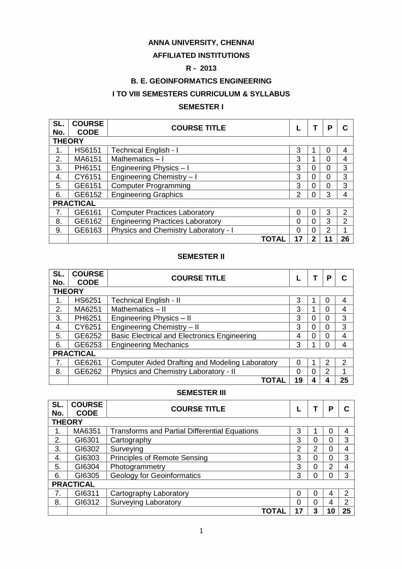
ANNA UNIVERSITY, CHENNAI
AFFILIATED INSTITUTIONS
R - 2013
B. E. GEOINFORMATICS ENGINEERING
I TO VIII SEMESTERS CURRICULUM & SYLLABUS
SEMESTER I
SL. No.
COURSE CODE
COURSE TITLE L T P C
THEORY
1. HS6151 Technical English - I 3 1 0 4
2. MA6151 Mathematics – I 3 1 0 4
3. PH6151 Engineering Physics – I 3 0 0 3
4. CY6151 Engineering Chemistry – I 3 0 0 3
5. GE6151 Computer Programming 3 0 0 3
6. GE6152 Engineering Graphics 2 0 3 4
PRACTICAL
7. GE6161 Computer Practices Laboratory 0 0 3 2
8. GE6162 Engineering Practices Laboratory 0 0 3 2
9. GE6163 Physics and Chemistry Laboratory - I 0 0 2 1
TOTAL 17 2 11 26
SEMESTER II
SL. No.
COURSE CODE
COURSE TITLE L T P C
THEORY
1. HS6251 Technical English - II 3 1 0 4
2. MA6251 Mathematics – II 3 1 0 4
3. PH6251 Engineering Physics – II 3 0 0 3
4. CY6251 Engineering Chemistry – II 3 0 0 3
5. GE6252 Basic Electrical and Electronics Engineering 4 0 0 4
6. GE6253 Engineering Mechanics 3 1 0 4
PRACTICAL
7. GE6261 Computer Aided Drafting and Modeling Laboratory 0 1 2 2
8. GE6262 Physics and Chemistry Laboratory - II 0 0 2 1
TOTAL 19 4 4 25
SEMESTER III
SL. No.
COURSE CODE
COURSE TITLE L T P C
THEORY
1. MA6351 Transforms and Partial Differential Equations 3 1 0 4
2. GI6301 Cartography 3 0 0 3
3. GI6302 Surveying 2 2 0 4
4. GI6303 Principles of Remote Sensing 3 0 0 3
5. GI6304 Photogrammetry 3 0 2 4
6. GI6305 Geology for Geoinformatics 3 0 0 3
PRACTICAL
7. GI6311 Cartography Laboratory 0 0 4 2
8. GI6312 Surveying Laboratory 0 0 4 2
TOTAL 17 3 10 25
2
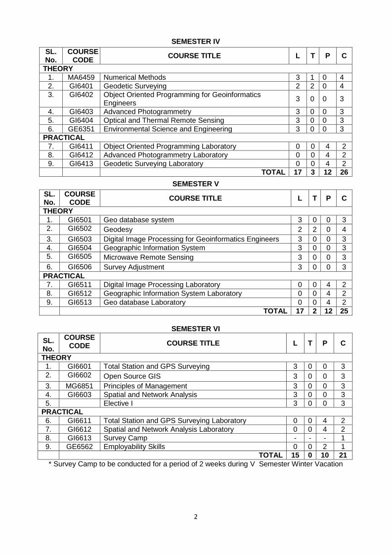
SEMESTER IV
SL. No.
COURSE CODE
COURSE TITLE L T P C
THEORY
1. MA6459 Numerical Methods 3 1 0 4
2. GI6401 Geodetic Surveying 2 2 0 4
3. GI6402 Object Oriented Programming for Geoinformatics Engineers
3 0 0 3
4. GI6403 Advanced Photogrammetry 3 0 0 3
5. GI6404 Optical and Thermal Remote Sensing 3 0 0 3
6. GE6351 Environmental Science and Engineering 3 0 0 3
PRACTICAL
7. GI6411 Object Oriented Programming Laboratory 0 0 4 2
8. GI6412 Advanced Photogrammetry Laboratory 0 0 4 2
9. GI6413 Geodetic Surveying Laboratory 0 0 4 2
TOTAL 17 3 12 26
SEMESTER V
SL. No.
COURSE CODE
COURSE TITLE L T P C
THEORY
1. GI6501 Geo database system 3 0 0 3
2. GI6502 Geodesy 2 2 0 4
3. GI6503 Digital Image Processing for Geoinformatics Engineers 3 0 0 3
4. GI6504 Geographic Information System 3 0 0 3
5. GI6505 Microwave Remote Sensing 3 0 0 3
6. GI6506 Survey Adjustment 3 0 0 3
PRACTICAL
7. GI6511 Digital Image Processing Laboratory 0 0 4 2
8. GI6512 Geographic Information System Laboratory 0 0 4 2
9. GI6513 Geo database Laboratory 0 0 4 2
TOTAL 17 2 12 25
SEMESTER VI
SL. No.
COURSE CODE COURSE TITLE L T P C
THEORY
1. GI6601 Total Station and GPS Surveying 3 0 0 3
2. GI6602 Open Source GIS 3 0 0 3
3. MG6851 Principles of Management 3 0 0 3
4. GI6603 Spatial and Network Analysis 3 0 0 3
5. Elective I 3 0 0 3
PRACTICAL
6. GI6611 Total Station and GPS Surveying Laboratory 0 0 4 2
7. GI6612 Spatial and Network Analysis Laboratory 0 0 4 2
8. GI6613 Survey Camp - - - 1
9. GE6562 Employability Skills 0 0 2 1
TOTAL 15 0 10 21
* Survey Camp to be conducted for a period of 2 weeks during V Semester Winter Vacation
3
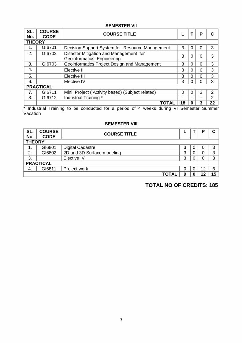
SEMESTER VII
SL. No.
COURSE CODE
COURSE TITLE L T P C
THEORY
1. GI6701 Decision Support System for Resource Management 3 0 0 3
2. GI6702 Disaster Mitigation and Management for Geoinformatics Engineering
3 0 0 3
3. GI6703 Geoinformatics Project Design and Management 3 0 0 3
4. Elective II 3 0 0 3
5. Elective III 3 0 0 3
6. Elective IV 3 0 0 3
PRACTICAL
7. GI6711 Mini Project ( Activity based) (Subject related) 0 0 3 2
8. GI6712 Industrial Training * - - - 2
TOTAL 18 0 3 22
* Industrial Training to be conducted for a period of 4 weeks during VI Semester Summer Vacation
SEMESTER VIII
SL. No.
COURSE CODE
COURSE TITLE L T P C
THEORY
1. GI6801 Digital Cadastre 3 0 0 3
2. GI6802 2D and 3D Surface modeling 3 0 0 3
3. Elective V 3 0 0 3
PRACTICAL
4. GI6811 Project work 0 0 12 6
TOTAL 9 0 12 15
TOTAL NO OF CREDITS: 185
4
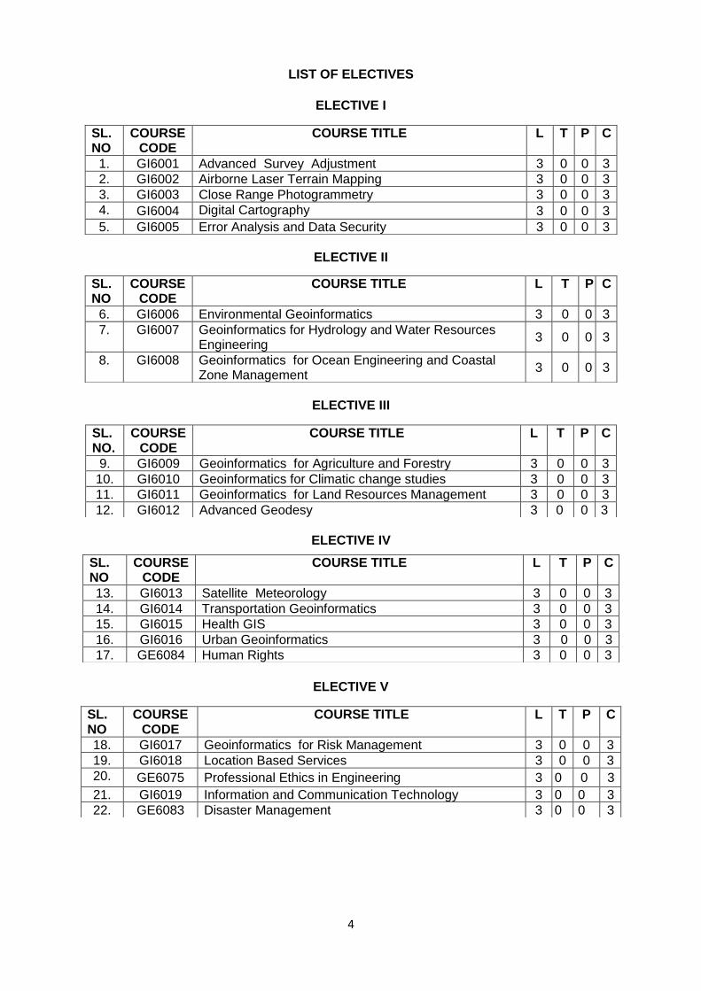
LIST OF ELECTIVES
ELECTIVE I
ELECTIVE II
ELECTIVE III
ELECTIVE IV
ELECTIVE V
SL. NO
COURSE CODE
COURSE TITLE L T P C
1. GI6001 Advanced Survey Adjustment 3 0 0 3
2. GI6002 Airborne Laser Terrain Mapping 3 0 0 3
3. GI6003 Close Range Photogrammetry 3 0 0 3
4. GI6004 Digital Cartography 3 0 0 3
5. GI6005 Error Analysis and Data Security 3 0 0 3
SL. NO
COURSE CODE
COURSE TITLE L T P C
6. GI6006 Environmental Geoinformatics 3 0 0 3
7. GI6007 Geoinformatics for Hydrology and Water Resources Engineering
3 0 0 3
8. GI6008 Geoinformatics for Ocean Engineering and Coastal Zone Management
3 0 0 3
SL. NO.
COURSE CODE
COURSE TITLE L T P C
9. GI6009 Geoinformatics for Agriculture and Forestry 3 0 0 3
10. GI6010 Geoinformatics for Climatic change studies 3 0 0 3
11. GI6011 Geoinformatics for Land Resources Management 3 0 0 3
12. GI6012 Advanced Geodesy 3 0 0 3
SL. NO
COURSE CODE
COURSE TITLE L T P C
13. GI6013 Satellite Meteorology 3 0 0 3
14. GI6014 Transportation Geoinformatics 3 0 0 3
15. GI6015 Health GIS 3 0 0 3
16. GI6016 Urban Geoinformatics 3 0 0 3
17. GE6084 Human Rights 3 0 0 3
SL. NO
COURSE CODE
COURSE TITLE L T P C
18. GI6017 Geoinformatics for Risk Management 3 0 0 3
19. GI6018 Location Based Services 3 0 0 3
20. GE6075 Professional Ethics in Engineering 3 0 0 3
21. GI6019 Information and Communication Technology 3 0 0 3
22. GE6083 Disaster Management 3 0 0 3
5
HS6151 TECHNICAL ENGLISH – I L T P C 3 1 0 4 OBJECTIVES:
To enable learners of Engineering and Technology develop their basic communication skills in English.
To emphasize specially the development of speaking skills amongst learners of Engineering and Technology.
To ensure that learners use the electronic media such as internet and supplement the learning materials used in the classroom.
To inculcate the habit of reading and writing leading to effective and efficient communication.
UNIT I 9+3
Listening - Introducing learners to GIE - Types of listening - Listening to audio (verbal & sounds); Speaking - Speaking about one‟s place, important festivals etc. – Introducing oneself, one‟s family / friend; Reading - Skimming a reading passage – Scanning for specific information - Note-making; Writing - Free writing on any given topic (My favourite place / Hobbies / School life, etc.) - Sentence completion - Autobiographical writing (writing about one‟s leisure time activities, hometown, etc.); Grammar - Prepositions - Reference words - Wh-questions - Tenses (Simple); Vocabulary - Word formation - Word expansion (root words / etymology); E-materials - Interactive exercises for Grammar & Vocabulary - Reading comprehension exercises - Listening to audio files and answering questions. UNIT II 9+3
Listening - Listening and responding to video lectures / talks; Speaking - Describing a simple process (filling a form, etc.) - Asking and answering questions - Telephone skills – Telephone etiquette; Reading – Critical reading - Finding key information in a given text - Sifting facts from opinions; Writing - Biographical writing (place, people) - Process descriptions (general/specific) - Definitions - Recommendations – Instructions; Grammar - Use of imperatives - Subject-verb agreement; Vocabulary - Compound words - Word Association (connotation); E-materials - Interactive exercises for Grammar and Vocabulary - Listening exercises with sample telephone conversations / lectures – Picture-based activities. UNIT III 9+3
Listening - Listening to specific task - focused audio tracks; Speaking - Role-play – Simulation - Group interaction - Speaking in formal situations (teachers, officials, foreigners); Reading - Reading and interpreting visual material; Writing - Jumbled sentences - Coherence and cohesion in writing - Channel conversion (flowchart into process) - Types of paragraph (cause and effect / compare and contrast / narrative / analytical) - Informal writing (letter/e-mail/blogs) - Paraphrasing; Grammar - Tenses (Past) - Use of sequence words - Adjectives; Vocabulary - Different forms and uses of words, Cause and effect words; E-materials - Interactive exercises for Grammar and Vocabulary - Excerpts from films related to the theme and follow up exercises - Pictures of flow charts and tables for interpretations. UNIT IV 9+3
Listening - Watching videos / documentaries and responding to questions based on them; Speaking - Responding to questions - Different forms of interviews - Speaking at different types of interviews; Reading - Making inference from the reading passage - Predicting the content of a reading passage; Writing - Interpreting visual materials (line graphs, pie charts etc.) - Essay writing – Different types of essays; Grammar - Adverbs – Tenses – future time reference; Vocabulary - Single word substitutes - Use of abbreviations and acronyms; E-materials - Interactive exercises for Grammar and Vocabulary - Sample interviews - film scenes - dialogue writing. UNIT V 9+3
Listening - Listening to different accents, Listening to Speeches/Presentations, Listening to broadcast and telecast from Radio and TV; Speaking - Giving impromptu talks, Making
6
presentations on given topics; Reading - Email communication - Reading the attachment files having a poem/joke/proverb - Sending their responses through email; Writing - Creative writing, Poster making; Grammar - Direct and indirect speech; Vocabulary - Lexical items (fixed / semi fixed expressions); E-materials - Interactive exercises for Grammar and Vocabulary - Sending emails with attachment – Audio / video excerpts of different accents - Interpreting posters.
TOTAL (L:45+T:15): 60 PERIODS
OUTCOMES: Learners should be able to
speak clearly, confidently, comprehensibly, and communicate with one or many listeners using appropriate communicative strategies.
write cohesively and coherently and flawlessly avoiding grammatical errors, using a wide vocabulary range, organizing their ideas logically on a topic.
read different genres of texts adopting various reading strategies.
listen/view and comprehend different spoken discourses/excerpts in different accents.
TEXTBOOKS: 1. Department of English, Anna University. Mindscapes: English for Technologists and
Engineers. Orient Blackswan, Chennai. 2012 2. Dhanavel, S.P. English and Communication Skills for Students of Science and
Engineering. Orient Blackswan, Chennai. 2011
REFERENCES: 1. Raman, Meenakshi & Sangeetha Sharma. Technical Communication: Principles and
Practice. Oxford University Press, New Delhi. 2011 2. Regional Institute of English. English for Engineers. Cambridge University Press, New
Delhi. 2006 3. Rizvi, Ashraf. M. Effective Technical Communication. Tata McGraw-Hill, New Delhi. 2005 4. Rutherford, Andrea. J Basic Communication Skills for Technology. Pearson, New Delhi.
2001 5. Viswamohan, Aysha. English for Technical Communication. Tata McGraw-Hill, New Delhi.
2008
EXTENSIVE Reading (Not for Examination) 1. Kalam, Abdul. Wings of Fire. Universities Press, Hyderabad. 1999.
WEBSITES: 1. http://www.usingenglish.com 2. http://www.uefap.com
TEACHING METHODS:
Lectures
Activities conducted individually, in pairs and in groups like self introduction, peer introduction, group poster making, grammar and vocabulary games, etc.
Discussions
Role play activities
Short presentations
Listening and viewing activities with follow up activities like discussion, filling up worksheets, writing exercises (using language lab wherever necessary/possible) etc.
EVALUATION PATTERN:
Internal assessment: 20% 3 tests of which two are pen and paper tests and the other is a combination of different modes of assessment like
Project
Assignment
Reviews
Creative writing
7
Poster making, etc.
All the four skills are to be tested with equal weightage given to each. Speaking assessment: Individual speaking activities, Pair work activities like role play,
Interview, Group discussions Reading assessment: Reading passages with comprehension questions graded from
simple to complex, from direct to inferential Writing assessment: Writing paragraphs, essays etc. Writing should include grammar and
vocabulary. Listening/Viewing assessment: Lectures, dialogues, film clippings with questions on verbal
as well as audio/visual content.
End Semester Examination: 80% MA6151 MATHEMATICS – I L T P C 3 1 0 4 OBJECTIVES:
To develop the use of matrix algebra techniques this is needed by engineers for practical applications.
To make the student knowledgeable in the area of infinite series and their convergence so that he/ she will be familiar with limitations of using infinite series approximations for solutions arising in mathematical modeling.
To familiarize the student with functions of several variables. This is needed in many branches of engineering.
To introduce the concepts of improper integrals, Gamma, Beta and Error functions which are needed in engineering applications.
To acquaint the student with mathematical tools needed in evaluating multiple integrals and their usage.
UNIT I MATRICES 9+3 Eigenvalues and Eigenvectors of a real matrix – Characteristic equation – Properties of eigenvalues and eigenvectors – Statement and applications of Cayley-Hamilton Theorem – Diagonalization of matrices – Reduction of a quadratic form to canonical form by orthogonal transformation – Nature of quadratic forms.
UNIT II SEQUENCES AND SERIES 9+3 Sequences: Definition and examples – Series: Types and Convergence – Series of positive terms – Tests of convergence: Comparison test, Integral test and D‟Alembert‟s ratio test – Alternating series – Leibnitz‟s test – Series of positive and negative terms – Absolute and conditional convergence.
UNIT III APPLICATIONS OF DIFFERENTIAL CALCULUS 9+3 Curvature in Cartesian co-ordinates – Centre and radius of curvature – Circle of curvature – Evolutes – Envelopes - Evolute as envelope of normals.
UNIT IV DIFFERENTIAL CALCULUS OF SEVERAL VARIABLES 9+3 Limits and Continuity – Partial derivatives – Total derivative – Differentiation of implicit functions – Jacobian and properties – Taylor‟s series for functions of two variables – Maxima and minima of functions of two variables – Lagrange‟s method of undetermined multipliers.
UNIT V MULTIPLE INTEGRALS 9+3 Double integrals in cartesian and polar coordinates – Change of order of integration – Area enclosed by plane curves – Change of variables in double integrals – Area of a curved surface - Triple integrals – Volume of Solids.
TOTAL (L:45+T:15): 60 PERIODS
8
OUTCOMES:
This course equips students to have basic knowledge and understanding in one fields of materials, integral and differential calculus.
TEXTBOOKS: 1. Bali N. P and Manish Goyal, “A Text book of Engineering Mathematics”, Eighth Edition,
Laxmi Publications Pvt Ltd., 2011.
2. Grewal. B.S, “Higher Engineering Mathematics”, 41st Edition, Khanna Publications, Delhi,
2011.
REFERENCES: 1. Dass, H.K., and Er. Rajnish Verma,” Higher Engineering Mathematics”, S. Chand Private
Ltd., 2011. 2. Glyn James, “Advanced Modern Engineering Mathematics”, 3rd Edition, Pearson
Education, 2012. 3. Peter V. O‟Neil,” Advanced Engineering Mathematics”, 7th Edition, Cengage learning,
2012. 4. Ramana B.V, “Higher Engineering Mathematics”, Tata McGraw Hill Publishing
Company, New Delhi, 2008. 5. Sivarama Krishna Das P. and Rukmangadachari E., “Engineering Mathematics”, Volume I,
Second Edition, PEARSON Publishing, 2011. PH6151 ENGINEERING PHYSICS – I L T P C 3 0 0 3
OBJECTIVES:
To enhance the fundamental knowledge in Physics and its applications relevant to various streams of Engineering and Technology.
UNIT I CRYSTAL PHYSICS 9 Lattice – Unit cell – Bravais lattice – Lattice planes – Miller indices – d spacing in cubic lattice – Calculation of number of atoms per unit cell – Atomic radius – Coordination number – Packing factor for SC, BCC, FCC and HCP structures – Diamond and graphite structures (qualitative treatment)- Crystal growth techniques –solution, melt (Bridgman and Czochralski) and vapour growth techniques (qualitative)
UNIT II PROPERTIES OF MATTER AND THERMAL PHYSICS 9 Elasticity- Hooke‟s law - Relationship between three modulii of elasticity (qualitative) – stress -strain diagram – Poisson‟s ratio –Factors affecting elasticity –Bending moment – Depression of a cantilever –Young‟s modulus by uniform bending- I-shaped girders Modes of heat transfer- thermal conductivity- Newton‟s law of cooling - Linear heat flow – Lee‟s disc method – Radial heat flow – Rubber tube method – conduction through compound media (series and parallel)
UNIT III QUANTUM PHYSICS 9 Black body radiation – Planck‟s theory (derivation) – Deduction of Wien‟s displacement law and Rayleigh – Jeans‟ Law from Planck‟s theory – Compton effect. Theory and experimental verification – Properties of Matter waves – G.P Thomson experiment -Schrödinger‟s wave equation – Time independent and time dependent equations – Physical significance of wave function – Particle in a one dimensional box - Electron microscope - Scanning electron microscope - Transmission electron microscope.
9
UNIT IV ACOUSTICS AND ULTRASONICS 9 Classification of Sound- decibel- Weber–Fechner law – Sabine‟s formula- derivation using growth and decay method – Absorption Coefficient and its determination –factors affecting acoustics of buildings and their remedies. Production of ultrasonics by magnetostriction and piezoelectric methods - acoustic grating -Non Destructive Testing – pulse echo system through transmission and reflection modes - A,B and C –scan displays, Medical applications - Sonogram UNIT V PHOTONICS AND FIBRE OPTICS 9 Spontaneous and stimulated emission- Population inversion -Einstein‟s A and B coefficients - derivation. Types of lasers – Nd:YAG, CO
2 , Semiconductor lasers (homojunction &
heterojunction)- Industrial and Medical Applications. Principle and propagation of light in optical fibres – Numerical aperture and Acceptance angle - Types of optical fibres (material, refractive index, mode) – attenuation, dispersion, bending - Fibre Optical Communication system (Block diagram) - Active and passive fibre sensors- Endoscope.
TOTAL: 45 PERIODS OUTCOMES:
The students will have knowledge on the basics of physics related to properties of matter, optics, acoustics etc., and they will apply these fundamental principles to solve practical problems related to materials used for engineering applications.
TEXTBOOKS: 1. Arumugam M. Engineering Physics. Anuradha publishers, 2010 2. Gaur R.K. and Gupta S.L. Engineering Physics, Dhanpat Rai publishers, 2009 3. Mani Naidu S. Engineering Physics, Second Edition, PEARSON Publishing, 2011.
REFERENCES: 1. Searls and Zemansky. University Physics, 2009 2. Mani P. Engineering Physics I. Dhanam Publications, 2011 3. Marikani A. Engineering Physics. PHI Learning Pvt., India, 2009 4. Palanisamy P.K. Engineering Physics. SCITECH Publications, 2011 5. Rajagopal K. Engineering Physics. PHI, New Delhi, 2011 6. Senthilkumar G. Engineering Physics I. VRB Publishers, 2011.
CY6151 ENGINEERING CHEMISTRY - I L T P C 3 0 0 3
OBJECTIVES:
To make the students conversant with basics of polymer chemistry.
To make the student acquire sound knowledge of second law of thermodynamics and second law based derivations of importance in engineering applications in all disciplines.
To acquaint the student with concepts of important photophysical and photochemical processes and spectroscopy.
To develop an understanding of the basic concepts of phase rule and its applications to single and two component systems and appreciate the purpose and significance of alloys.
To acquaint the students with the basics of nano materials, their properties and applications.
UNIT I POLYMER CHEMISTRY 9 Introduction: Classification of polymers – Natural and synthetic; Thermoplastic and Thermosetting. Functionality – Degree of polymerization. Types and mechanism of polymerization: Addition (Free Radical, cationic and anionic); condensation and copolymerization. Properties of polymers: Tg, Tacticity, Molecular weight – weight average, number average and polydispersity index. Techniques of polymerization: Bulk, emulsion, solution and suspension. Preparation, properties and uses of Nylon 6,6, and Epoxy resin.
10
UNIT II CHEMICAL THERMODYNAMICS 9 Terminology of thermodynamics - Second law: Entropy - entropy change for an ideal gas, reversible and irreversible processes; entropy of phase transitions; Clausius inequality. Free energy and work function: Helmholtz and Gibbs free energy functions (problems); Criteria of spontaneity; Gibbs-Helmholtz equation (problems); Clausius-Clapeyron equation; Maxwell relations – Van‟t Hoff isotherm and isochore(problems). UNIT III PHOTOCHEMISTRY AND SPECTROSCOPY 9 Photochemistry: Laws of photochemistry - Grotthuss–Draper law, Stark–Einstein law and Lambert-Beer Law. Quantum efficiency – determination- Photo processes - Internal Conversion, Inter-system crossing, Fluorescence, Phosphorescence, Chemiluminescence and Photo-sensitization. Spectroscopy: Electromagnetic spectrum - Absorption of radiation – Electronic, Vibrational and rotational transitions. UV-visible and IR spectroscopy – principles, instrumentation (Block diagram only). UNIT IV PHASE RULE AND ALLOYS 9 Phase rule: Introduction, definition of terms with examples, One Component System- water system - Reduced phase rule - Two Component Systems- classification – lead-silver system, zinc-magnesium system. Alloys: Introduction- Definition- Properties of alloys- Significance of alloying, Functions and effect of alloying elements- Ferrous alloys- Nichrome and Stainless steel – heat treatment of steel; Non-ferrous alloys – brass and bronze. UNIT V NANOCHEMISTRY 9 Basics - distinction between molecules, nanoparticles and bulk materials; size-dependent properties. nanoparticles: nano cluster, nano rod, nanotube(CNT) and nanowire. Synthesis: precipitation, thermolysis, hydrothermal, solvothermal, electrodeposition, chemical vapour deposition, laser ablation; Properties and applications
TOTAL :45 PERIODS OUTCOMES:
The knowledge gained on polymer chemistry, thermodynamics. spectroscopy, phase rule and nano materials will provide a strong platform to understand the concepts on these subjects for further learning.
TEXTBOOKS: 1. Jain P.C. and Monica Jain, “Engineering Chemistry”, Dhanpat Rai Publishing Company
(P) Ltd., New Delhi, 2010 2. Kannan P., Ravikrishnan A., “Engineering Chemistry”, Sri Krishna Hi-tech Publishing
Company Pvt. Ltd. Chennai, 2009
REFERENCES: 1. Dara S.S, Umare S.S, “Engineering Chemistry”, S. Chand & Company Ltd., New Delhi
2010 2. Sivasankar B., “Engineering Chemistry”, Tata McGraw-Hill Publishing Company, Ltd., New
Delhi, 2008. 3. Gowariker V.R. , Viswanathan N.V. and JayadevSreedhar, “Polymer Science”, New Age
International P (Ltd.,), Chennai, 2006. 4. Ozin G. A. and Arsenault A. C., “Nanochemistry: A Chemical Approach to Nanomaterials”,
RSC Publishing, 2005. GE6151 COMPUTER PROGRAMMING L T P C 3 0 0 3 OBJECTIVES:
The students should be made to:
Learn the organization of a digital computer.
Be exposed to the number systems.
11
Learn to think logically and write pseudo code or draw flow charts for problems.
Be exposed to the syntax of C.
Be familiar with programming in C.
Learn to use arrays, strings, functions, pointers, structures and unions in C. UNIT I INTRODUCTION 8 Generation and Classification of Computers- Basic Organization of a Computer –Number System – Binary – Decimal – Conversion – Problems. Need for logical analysis and thinking – Algorithm – Pseudo code – Flow Chart.
UNIT II C PROGRAMMING BASICS 10 Problem formulation – Problem Solving - Introduction to „ C‟ programming –fundamentals – structure of a „C‟ program – compilation and linking processes – Constants, Variables – Data Types – Expressions using operators in „C‟ – Managing Input and Output operations – Decision Making and Branching – Looping statements – solving simple scientific and statistical problems.
UNIT III ARRAYS AND STRINGS 9 Arrays – Initialization – Declaration – One dimensional and Two dimensional arrays. String- String operations – String Arrays. Simple programs- sorting- searching – matrix operations.
UNIT IV FUNCTIONS AND POINTERS 9 Function – definition of function – Declaration of function – Pass by value – Pass by reference – Recursion – Pointers - Definition – Initialization – Pointers arithmetic – Pointers and arrays- Example Problems.
UNIT V STRUCTURES AND UNIONS 9 Introduction – need for structure data type – structure definition – Structure declaration – Structure within a structure - Union - Programs using structures and Unions – Storage classes, Pre-processor directives.
TOTAL: 45 PERIODS OUTCOMES:
At the end of the course, the student should be able to:
Design C Programs for problems.
Write and execute C programs for simple applications
TEXTBOOKS:
1. Anita Goel and Ajay Mittal, “Computer Fundamentals and Programming in C”, Dorling Kindersley (India) Pvt. Ltd., Pearson Education in South Asia, 2011.
2. Pradip Dey, Manas Ghosh, “Fundamentals of Computing and Programming in C”, First Edition, Oxford University Press, 2009
3. Yashavant P. Kanetkar. “ Let Us C”, BPB Publications, 2011.
REFERENCES: 1. Byron S Gottfried, “Programming with C”, Schaum‟s Outlines, Second Edition, Tata
McGraw-Hill, 2006. 2. Dromey R.G., “How to Solve it by Computer”, Pearson Education, Fourth Reprint, 2007. 3. Kernighan,B.W and Ritchie,D.M, “The C Programming language”, Second Edition, Pearson
Education, 2006.
GE6152 ENGINEERING GRAPHICS L T P C 2 0 3 4
OBJECTIVES:
To develop in students, graphic skills for communication of concepts, ideas and design of Engineering products
T o expose them to existing national standards related to technical drawings.
12
CONCEPTS AND CONVENTIONS (Not for Examination) 1 Importance of graphics in engineering applications – Use of drafting instruments – BIS conventions and specifications – Size, layout and folding of drawing sheets – Lettering and dimensioning.
UNIT I PLANE CURVES AND FREE HAND SKETCHING 5+9 Basic Geometrical constructions, Curves used in engineering practices: Conics – Construction of ellipse, parabola and hyperbola by eccentricity method – Construction of cycloid – construction of involutes of square and circle – Drawing of tangents and normal to the above curves, Scales: Construction of Diagonal and Vernier scales. Visualization concepts and Free Hand sketching: Visualization principles –Representation of Three Dimensional objects – Layout of views- Free hand sketching of multiple views from pictorial views of objects
UNIT II PROJECTION OF POINTS, LINES AND PLANE SURFACES 5+9 Orthographic projection- principles-Principal planes-First angle projection-projection of points. Projection of straight lines (only First angle projections) inclined to both the principal planes - Determination of true lengths and true inclinations by rotating line method and traces Projection of planes (polygonal and circular surfaces) inclined to both the principal planes by rotating object method.
UNIT III PROJECTION OF SOLIDS 5 + 9 Projection of simple solids like prisms, pyramids, cylinder, cone and truncated solids when the axis is inclined to one of the principal planes by rotating object method and auxiliary plane method.
UNIT IV PROJECTION OF SECTIONED SOLIDS AND DEVELOPMENT OF SURFACES 5+9
Sectioning of above solids in simple vertical position when the cutting plane is inclined to the one of the principal planes and perpendicular to the other – obtaining true shape of section. Development of lateral surfaces of simple and sectioned solids – Prisms, pyramids cylinders and cones. Development of lateral surfaces of solids with cut-outs and holes
UNIT V ISOMETRIC AND PERSPECTIVE PROJECTIONS 6 + 9 Principles of isometric projection – isometric scale –Isometric projections of simple solids and truncated solids - Prisms, pyramids, cylinders, cones- combination of two solid objects in simple vertical positions and miscellaneous problems. Perspective projection of simple solids-Prisms, pyramids and cylinders by visual ray method .
COMPUTER AIDED DRAFTING (Demonstration Only) 3 Introduction to drafting packages and demonstration of their use.
TOTAL : 75 PERIODS
OUTCOMES: On Completion of the course the student will be able to
perform free hand sketching of basic geometrical constructions and multiple views of objects.
do orthographic projection of lines and plane surfaces.
draw projections and solids and development of surfaces.
prepare isometric and perspective sections of simple solids.
demonstrate computer aided drafting.
TEXTBOOK: 1. Bhatt N.D. and Panchal V.M., “Engineering Drawing”, Charotar Publishing House, 50th
Edition, 2010.
REFERENCES:
1. Gopalakrishna K.R., “Engineering Drawing” (Vol. I&II combined), Subhas Stores, Bangalore, 2007.
13
2. Luzzader, Warren.J. and Duff,John M., “Fundamentals of Engineering Drawing with an introduction to Interactive Computer Graphics for Design and Production, Eastern Economy Edition, Prentice Hall of India Pvt. Ltd, New Delhi, 2005.
3. Shah M.B., and Rana B.C., “Engineering Drawing”, Pearson, 2nd Edition, 2009. 4. Venugopal K. and Prabhu Raja V., “Engineering Graphics”, New Age International (P)
Limited, 2008. 5. Natrajan K.V., “A text book of Engineering Graphics”, Dhanalakshmi Publishers,
Chennai, 2009. 6. Basant Agarwal and Agarwal C.M., “Engineering Drawing”, Tata McGraw Hill Publishing
Company Limited, New Delhi, 2008.
Publication of Bureau of Indian Standards: 1. IS 10711 – 2001: Technical products Documentation – Size and lay out of drawing
sheets. 2. IS 9609 (Parts 0 & 1) – 2001: Technical products Documentation – Lettering. 3. IS 10714 (Part 20) – 2001 & SP 46 – 2003: Lines for technical drawings. 4. IS 11669 – 1986 & SP 46 – 2003: Dimensioning of Technical Drawings. 5. IS 15021 (Parts 1 to 4) – 2001: Technical drawings – Projection Methods.
Special points applicable to University Examinations on Engineering Graphics: 1. There will be five questions, each of either or type covering all units of the syllabus. 2. All questions will carry equal marks of 20 each making a total of 100. 3. The answer paper shall consist of drawing sheets of A3 size only. The students
will be permitted to use appropriate scale to fit solution within A3 size. 4. The examination will be conducted in appropriate sessions on the same day
GE6161 COMPUTER PRACTICES LABORATORY L T P C
0 0 3 2 OBJECTIVES: The student should be made to:
Be familiar with the use of Office software.
Be exposed to presentation and visualization tools.
Be exposed to problem solving techniques and flow charts.
Be familiar with programming in C.
Learn to use Arrays, strings, functions, structures and unions.
LIST OF EXPERIMENTS: 1. Search, generate, manipulate data using MS office/ Open Office 2. Presentation and Visualization – graphs, charts, 2D, 3D 3. Problem formulation, Problem Solving and Flowcharts 4. C Programming using Simple statements and expressions 5. Scientific problem solving using decision making and looping. 6. Simple programming for one dimensional and two dimensional arrays. 7. Solving problems using String functions 8. Programs with user defined functions – Includes Parameter Passing 9. Program using Recursive Function and conversion from given program to flow chart. 10. Program using structures and unions.
TOTAL : 45 PERIODS
OUTCOMES: At the end of the course, the student should be able to:
Apply good programming design methods for program development.
Design and implement C programs for simple applications.
Develop recursive programs.
14
LIST OF EQUIPMENT FOR A BATCH OF 30 STUDENTS:
Standalone desktops with C compiler 30 Nos.
(or)
Server with C compiler supporting 30 terminals or more.
GE6162 ENGINEERING PRACTICES LABORATORY L T P C 0 0 3 2
OBJECTIVES:
To provide exposure to the students with hands on experience on various basic engineering practices in Civil, Mechanical, Electrical and Electronics Engineering.
GROUP A (CIVIL & MECHANICAL)
I CIVIL ENGINEERING PRACTICE 9 Buildings:
(a) Study of plumbing and carpentry components of residential and industrial buildings. Safety aspects.
Plumbing Works: (a) Study of pipeline joints, its location and functions: valves, taps, couplings, unions, reducers,
elbows in household fittings. (b) Study of pipe connections requirements for pumps and turbines. (c) Preparation of plumbing line sketches for water supply and sewage works. (d) Hands-on-exercise:
Basic pipe connections – Mixed pipe material connection – Pipe connections with different joining components.
(e) Demonstration of plumbing requirements of high-rise buildings.
Carpentry using Power Tools only: (a) Study of the joints in roofs, doors, windows and furniture. (b) Hands-on-exercise:
Wood work, joints by sawing, planing and cutting.
II MECHANICAL ENGINEERING PRACTICE 13
Welding: (a) Preparation of arc welding of butt joints, lap joints and tee joints.
(b) Gas welding practice
Basic Machining: (a) Simple Turning and Taper turning (b) Drilling Practice
Sheet Metal Work: (a) Forming & Bending: (b) Model making – Trays, funnels, etc. (c) Different type of joints. Machine assembly practice:
(a) Study of centrifugal pump (b) Study of air conditioner
Demonstration on: (a) Smithy operations, upsetting, swaging, setting down and bending. Example – Exercise – Production of hexagonal headed bolt.
15
(b) Foundry operations like mould preparation for gear and step cone pulley. (c) Fitting – Exercises – Preparation of square fitting and vee – fitting models.
GROUP B (ELECTRICAL & ELECTRONICS) III ELECTRICAL ENGINEERING PRACTICE 10
1. Residential house wiring using switches, fuse, indicator, lamp and energy meter. 2. Fluorescent lamp wiring. 3. Stair case wiring 4. Measurement of electrical quantities – voltage, current, power & power factor in RLC
circuit. 5. Measurement of energy using single phase energy meter. 6. Measurement of resistance to earth of an electrical equipment.
IV ELECTRONICS ENGINEERING PRACTICE 13
1. Study of Electronic components and equipments – Resistor, colour coding measurement of AC signal parameter (peak-peak, rms period, frequency) using CR. 2. Study of logic gates AND, OR, EOR and NOT. 3. Generation of Clock Signal. 4. Soldering practice – Components Devices and Circuits – Using general purpose PCB. 5. Measurement of ripple factor of HWR and FWR.
TOTAL: 45 PERIODS OUTCOMES:
ability to fabricate plumbing and carbending components
ability to use welding equipments to join the structures
ability to fabricate electrical and electronics circuits
REFERENCES: 1. Jeyachandran K., Natarajan S. & Balasubramanian S., “A Primer on Engineering
Practices Laboratory”, Anuradha Publications, 2007. 2. Jeyapoovan T., Saravanapandian M. & Pranitha S., “Engineering Practices Lab Manual”,
Vikas Puplishing House Pvt.Ltd, 2006 3. Bawa H.S., “Workshop Practice”, Tata McGraw – Hill Publishing Company Limited, 2007. 4. Rajendra Prasad A. & Sarma P.M.M.S., “Workshop Practice”, Sree Sai Publication, 2002. 5. Kannaiah P. & Narayana K.L., “Manual on Workshop Practice”, Scitech Publications, 1999.
LIST OF EQUIPMENT FOR A BATCH OF 30 STUDENTS:
CIVIL 1. Assorted components for plumbing consisting of metallic pipes, plastic pipes, flexible pipes, couplings, unions, elbows, plugs and other fittings. 15 Sets. 2. Carpentry vice (fitted to work bench) 15 Nos. 3. Standard woodworking tools 15 Sets. 4. Models of industrial trusses, door joints, furniture joints 5 each 5. Power Tools: (a) Rotary Hammer 2 Nos (b) Demolition Hammer 2 Nos (c) Circular Saw 2 Nos (d) Planer 2 Nos (e) Hand Drilling Machine 2 Nos (f) Jigsaw 2 Nos
MECHANICAL 1. Arc welding transformer with cables and holders 5 Nos. 2. Welding booth with exhaust facility 5 Nos. 3. Welding accessories like welding shield, chipping hammer,
16
wire brush, etc. 5 Sets. 4. Oxygen and acetylene gas cylinders, blow pipe and other welding outfit. 2 Nos. 5. Centre lathe 2 Nos. 6. Hearth furnace, anvil and smithy tools 2 Sets. 7. Moulding table, foundry tools 2 Sets. 8. Power Tool: Angle Grinder 2 Nos 9. Study-purpose items: centrifugal pump, air-conditioner One each.
ELECTRICAL 1. Assorted electrical components for house wiring 15 Sets 2. Electrical measuring instruments 10 Sets 3. Study purpose items: Iron box, fan and regulator, emergency lamp 1 each 4. Megger (250V/500V) 1 No. 5. Power Tools: (a) Range Finder 2 Nos (b) Digital Live-wire detector 2 Nos
ELECTRONICS 1. Soldering guns 10 Nos. 2. Assorted electronic components for making circuits 50 Nos. 3. Small PCBs 10 Nos. 4. Multimeters 10 Nos. 5. Study purpose items: Telephone, FM radio, low-voltage power supply
GE6163 PHYSICS AND CHEMISTRY LABORATORY – I L T P C
0 0 2 1 PHYSICS LABORATORY – I
OBJECTIVES:
To introduce different experiments to test basic understanding of physics concepts applied in optics, thermal physics and properties of matter.
LIST OF EXPERIMENTS (Any FIVE Experiments) 1. (a) Determination of Wavelength, and particle size using Laser
(b) Determination of acceptance angle in an optical fiber. 2. Determination of velocity of sound and compressibility of liquid – Ultrasonic interferometer. 3. Determination of wavelength of mercury spectrum – spectrometer grating 4. Determination of thermal conductivity of a bad conductor – Lee‟s Disc method. 5. Determination of Young‟s modulus by Non uniform bending method 6. Determination of specific resistance of a given coil of wire – Carey Foster‟s Bridge OUTCOMES:
The hands on exercises undergone by the students will help them to apply physics principles of optics and thermal physics to evaluate engineering properties of materials.
LIST OF EQUIPMENT FOR A BATCH OF 30 STUDENTS:
1. Diode laser, lycopodium powder, glass plate, optical fiber. 2. Ultrasonic interferometer 3. Spectrometer, mercury lamp, grating 4. Lee‟s Disc experimental set up 5. Traveling microscope, meter scale, knife edge, weights 6. Carey foster‟s bridge set up
(vernier Caliper, Screw gauge, reading lens are required for most of the experiments)
17
CHEMISTRY LABORATORY- I
OBJECTIVES:
To make the student to acquire practical skills in the determination of water quality parameters through volumetric and instrumental analysis.
To acquaint the students with the determination of molecular weight of a polymer by vacometry.
LIST OF EXPERIMENTS (Any FIVE Experiments)
1 Determination of DO content of water sample by Winkler‟s method. 2 Determination of chloride content of water sample by argentometric method. 3 Determination of strength of given hydrochloric acid using pH meter. 4 Determination of strength of acids in a mixture using conductivity meter. 5 Estimation of iron content of the water sample using spectrophotometer.
(1,10- phenanthroline / thiocyanate method). 6 Determination of molecular weight of polyvinylalcohol using Ostwald viscometer. 7 Conductometric titration of strong acid vs strong base.
TOTAL: 30 PERIODS OUTCOMES:
The students will be outfitted with hands-on knowledge in the quantitative chemical analysis of water quality related parameters.
REFERENCES: 1. Daniel R. Palleros, “Experimental organic chemistry” John Wiley & Sons, Inc., New York
2001. 2. Furniss B.S. Hannaford A.J, Smith P.W.G and Tatchel A.R., “Vogel‟s Textbook of practical
organic chemistry”, LBS Singapore, 1994. 3. Jeffery G.H., Bassett J., Mendham J.and Denny vogel‟s R.C, “Text book of quantitative
analysis chemical analysis”, ELBS 5th Edn. Longman, Singapore publishers, Singapore, 1996.
4. Kolthoff I.M., Sandell E.B. et al. “Quantitative chemical analysis”, Mcmillan, Madras, 1980
LIST OF EQUIPMENT FOR A BATCH OF 30 STUDENTS:
1. Iodine flask - 30 Nos 2. pH meter - 5 Nos 3. Conductivity meter - 5 Nos 4. Spectrophotometer - 5 Nos 5. Ostwald Viscometer - 10 Nos
Common Apparatus : Pipette, Burette, conical flask, percelain tile, dropper (each 30 Nos.)
HS6251 TECHNICAL ENGLISH II L T P C 3 1 0 4
OBJECTIVES:
To make learners acquire listening and speaking skills in both formal and informal contexts.
To help them develop their reading skills by familiarizing them with different types of reading strategies.
To equip them with writing skills needed for academic as well as workplace contexts.
To make them acquire language skills at their own pace by using e-materials and language lab components.
18
UNIT I 9+3 Listening - Listening to informal conversations and participating; Speaking - Opening a conversation (greetings, comments on topics like weather) - Turn taking - Closing a conversation (excuses, general wish, positive comment, thanks); Reading - Developing analytical skills, Deductive and inductive reasoning - Extensive reading; Writing - Effective use of SMS for sending short notes and messages - Using „emoticons‟ as symbols in email messages; Grammar - Regular and irregular verbs - Active and passive voice; Vocabulary - Homonyms (e.g. „can‟) - Homophones (e.g. „some‟, „sum‟); E-materials - Interactive exercise on Grammar and vocabulary – blogging; Language Lab - Listening to different types of conversation and answering questions. UNIT II 9+3 Listening - Listening to situation based dialogues; Speaking - Conversation practice in real life situations, asking for directions (using polite expressions), giving directions (using imperative sentences), Purchasing goods from a shop, Discussing various aspects of a film (they have already seen) or a book (they have already read); Reading - Reading a short story or an article from newspaper, Critical reading, Comprehension skills; Writing - Writing a review / summary of a story / article, Personal letter (Inviting your friend to a function, congratulating someone for his / her success, thanking one‟s friends / relatives); Grammar - modal verbs, Purpose expressions; Vocabulary - Phrasal verbs and their meanings, Using phrasal verbs in sentences; E-materials - Interactive exercises on Grammar and vocabulary, Extensive reading activity (reading stories / novels), Posting reviews in blogs - Language Lab - Dialogues (Fill up exercises), Recording students‟ dialogues. UNIT III 9+3 Listening - Listening to the conversation - Understanding the structure of conversations; Speaking - Conversation skills with a sense of stress, intonation, pronunciation and meaning - Seeking information – expressing feelings (affection, anger, regret, etc.); Reading - Speed reading – reading passages with time limit - Skimming; Writing - Minutes of meeting – format and practice in the preparation of minutes - Writing summary after reading articles from journals - Format for journal articles – elements of technical articles (abstract, introduction, methodology, results, discussion, conclusion, appendices, references) - Writing strategies; Grammar - Conditional clauses - Cause and effect expressions; Vocabulary - Words used as nouns and verbs without any change in the spelling (e.g. „rock‟, „train‟, „ring‟); E-materials - Interactive exercise on Grammar and vocabulary - Speed Reading practice exercises; Language Lab - Intonation practice using EFLU and RIE materials – Attending a meeting and writing minutes. UNIT IV 9+3 Listening - Listening to a telephone conversation, Viewing model interviews (face-to-face, telephonic and video conferencing); Speaking - Role play practice in telephone skills - listening and responding, -asking questions, -note taking – passing on messages, Role play and mock interview for grasping interview skills; Reading - Reading the job advertisements and the profile of the company concerned – scanning; Writing - Applying for a job – cover letter - résumé preparation – vision, mission and goals of the candidate; Grammar - Numerical expressions - Connectives (discourse markers); Vocabulary - Idioms and their meanings – using idioms in sentences; E-materials - Interactive exercises on Grammar and Vocabulary - Different forms of résumés- Filling up a résumé / cover letter; Language Lab - Telephonic interview – recording the responses - e-résumé writing. UNIT V 9+3 Listening - Viewing a model group discussion and reviewing the performance of each participant - Identifying the characteristics of a good listener; Speaking - Group discussion skills – initiating the discussion – exchanging suggestions and proposals – expressing dissent/agreement – assertiveness in expressing opinions – mind mapping technique; Reading - Note making skills – making notes from books, or any form of written materials - Intensive reading; Writing – Checklist - Types of reports – Feasibility / Project report – report format – recommendations / suggestions – interpretation of data (using charts for effective presentation); Grammar - Use of clauses; Vocabulary – Collocation; E-materials - Interactive grammar and vocabulary exercises - Sample
19
GD - Pictures for discussion, Interactive grammar and vocabulary exercises; Language Lab - Different models of group discussion.
TOTAL (L:45+T:15): 60 PERIODS OUTCOMES: Learners should be able to
speak convincingly, express their opinions clearly, initiate a discussion, negotiate, argue using appropriate communicative strategies.
write effectively and persuasively and produce different types of writing such as narration, description, exposition and argument as well as creative, critical, analytical and evaluative writing.
read different genres of texts, infer implied meanings and critically analyse and evaluate them for ideas as well as for method of presentation.
listen/view and comprehend different spoken excerpts critically and infer unspoken and implied meanings.
TEXTBOOKS: 1. Department of English, Anna University. Mindscapes: English for Technologists and
Engineers. Orient Blackswan, Chennai. 2012 2. Dhanavel, S.P. English and Communication Skills for Students of Science and
Engineering. Orient Blackswan, Chennai. 2011
REFERENCES: 1. Anderson, Paul V. Technical Communication: A Reader-Centered Approach. Cengage.
New Delhi. 2008 2. Muralikrishna, & Sunita Mishra. Communication Skills for Engineers. Pearson, New Delhi.
2011 3. Riordan, Daniel. G. Technical Communication. Cengage Learning, New Delhi. 2005 4. Sharma, Sangeetha & Binod Mishra. Communication Skills for Engineers and Scientists.
PHI Learning, New Delhi. 2009 5. Smith-Worthington, Darlene & Sue Jefferson. Technical Writing for Success. Cengage,
Mason USA. 2007
EXTENSIVE Reading (Not for Examination) 1. Khera, Shiv. You can Win. Macmillan, Delhi. 1998.
Websites 1. http://www.englishclub.com 2. http://owl.english.purdue.edu
TEACHING METHODS:
Lectures
Activities conducted individually, in pairs and in groups like individual writing and presentations, group discussions, interviews, reporting, etc
Long presentations using visual aids
Listening and viewing activities with follow up activities like discussions, filling up worksheets, writing exercises (using language lab wherever necessary/possible) etc
Projects like group reports, mock interviews etc using a combination of two or more of the language skills
EVALUATION PATTERN:
Internal assessment: 20% 3 tests of which two are pen and paper tests and the other is a combination of different modes of assessment like
Project
Assignment
Report
Creative writing, etc.
All the four skills are to be tested with equal weightage given to each.
20
Speaking assessment: Individual presentations, Group discussions Reading assessment: Reading passages with comprehension questions graded following
Bloom‟s taxonomy Writing assessment: Writing essays, CVs, reports etc. Writing should include grammar and
vocabulary. Listening/Viewing assessment: Lectures, dialogues, film clippings with questions on verbal
as well as audio/visual content graded following Bloom‟s taxonomy.
End Semester Examination: 80%
MA6251 MATHEMATICS – II L T P C 3 1 0 4
OBJECTIVES:
To make the student acquire sound knowledge of techniques in solving ordinary differential equations that model engineering problems.
To acquaint the student with the concepts of vector calculus, needed for problems in all engineering disciplines.
To develop an understanding of the standard techniques of complex variable theory so as to enable the student to apply them with confidence, in application areas such as heat conduction, elasticity, fluid dynamics and flow the of electric current.
To make the student appreciate the purpose of using transforms to create a new domain in which it is easier to handle the problem that is being investigated.
UNIT I VECTOR CALCULUS 9+3 Gradient, divergence and curl – Directional derivative – Irrotational and solenoidal vector fields – Vector integration – Green‟s theorem in a plane, Gauss divergence theorem and Stokes‟ theorem (excluding proofs) – Simple applications involving cubes and rectangular parallelopipeds. UNIT II ORDINARY DIFFERENTIAL EQUATIONS 9+3 Higher order linear differential equations with constant coefficients – Method of variation of parameters – Cauchy‟s and Legendre‟s linear equations – Simultaneous first order linear equations with constant coefficients. UNIT III LAPLACE TRANSFORM 9+3 Laplace transform – Sufficient condition for existence – Transform of elementary functions – Basic properties – Transforms of derivatives and integrals of functions - Derivatives and integrals of transforms - Transforms of unit step function and impulse functions – Transform of periodic functions. Inverse Laplace transform -Statement of Convolution theorem – Initial and final value theorems – Solution of linear ODE of second order with constant coefficients using Laplace transformation techniques.
UNIT IV ANALYTIC FUNCTIONS 9+3 Functions of a complex variable – Analytic functions: Necessary conditions – Cauchy-Riemann equations and sufficient conditions (excluding proofs) – Harmonic and orthogonal properties of analytic function – Harmonic conjugate – Construction of analytic functions – Conformal mapping: w = z+k, kz, 1/z, z2, ez and bilinear transformation.
UNIT V COMPLEX INTEGRATION 9+3 Complex integration – Statement and applications of Cauchy‟s integral theorem and Cauchy‟s integral formula – Taylor‟s and Laurent‟s series expansions – Singular points – Residues – Cauchy‟s residue theorem – Evaluation of real definite integrals as contour integrals around unit circle and semi-circle (excluding poles on the real axis).
TOTAL (L:45+T:15): 60 PERIODS
21
OUTCOMES:
The subject helps the students to develop the fundamentals and basic concepts in vector calculus, ODE, Laplace transform and complex functions. Students will be able to solve problems related to engineering applications by using these techniques.
TEXTBOOKS: 1. Bali N. P and Manish Goyal, “A Text book of Engineering Mathematics”, Eighth Edition,
Laxmi Publications Pvt Ltd.,(2011).
2. Grewal. B.S, “Higher Engineering Mathematics”, 41st
Edition, Khanna Publications, Delhi, (2011).
REFERENCES: 1. Dass, H.K., and Er. Rajnish Verma,” Higher Engineering Mathematics”, S. Chand Private
Ltd., 2011. 2. Glyn James, “Advanced Modern Engineering Mathematics”, 3rd Edition, Pearson
Education, 2012. 3. Peter V. O‟Neil,” Advanced Engineering Mathematics”, 7th Edition, Cengage learning,
2012. 4. Ramana B.V, “Higher Engineering Mathematics”, Tata McGraw Hill Publishing Company,
New Delhi, 2008. 5. Sivarama Krishna Das P. and Rukmangadachari E., “Engineering Mathematics” Volume II,
Second Edition, PEARSON Publishing, 2011.
PH6251 ENGINEERING PHYSICS – II L T P C 3 0 0 3
OBJECTIVES:
To enrich the understanding of various types of materials and their applications in engineering and technology.
UNIT I CONDUCTING MATERIALS 9 Conductors – classical free electron theory of metals – Electrical and thermal conductivity – Wiedemann – Franz law – Lorentz number – Draw backs of classical theory – Quantum theory – Fermi distribution function – Effect of temperature on Fermi Function – Density of energy states – carrier concentration in metals.
UNIT II SEMICONDUCTING MATERIALS 9 Intrinsic semiconductor – carrier concentration derivation – Fermi level – Variation of Fermi level with temperature – electrical conductivity – band gap determination – compound semiconductors -direct and indirect band gap- derivation of carrier concentration in n-type and p-type semiconductor – variation of Fermi level with temperature and impurity concentration –– Hall effect –Determination of Hall coefficient – Applications. UNIT III MAGNETIC AND SUPERCONDUCTING MATERIALS 9 Origin of magnetic moment – Bohr magneton – comparison of Dia, Para and Ferro magnetism – Domain theory – Hysteresis – soft and hard magnetic materials – antiferromagnetic materials – Ferrites and its applications Superconductivity : properties – Type I and Type II superconductors – BCS theory of superconductivity(Qualitative) - High Tc superconductors – Applications of superconductors – SQUID, cryotron, magnetic levitation.
UNIT IV DIELECTRIC MATERIALS 9 Electrical susceptibility – dielectric constant – electronic, ionic, orientational and space charge polarization – frequency and temperature dependence of polarisation – internal field – Claussius – Mosotti relation (derivation) – dielectric loss – dielectric breakdown – uses of dielectric materials (capacitor and transformer) – ferroelectricity and applications.
22
UNIT V ADVANCED ENGINEERING MATERIALS 9 Metallic glasses: preparation, properties and applications. Shape memory alloys (SMA): Characteristics, properties of NiTi alloy, application, Nanomaterials– Preparation -pulsed laser deposition – chemical vapour deposition – Applications – NLO materials –Birefringence- optical Kerr effect – Classification of Biomaterials and its applications
TOTAL: 45 PERIODS OUTCOMES:
The students will have the knowledge on physics of materials and that knowledge will be used by them in different engineering and technology applications.
TEXTBOOKS: 1. Arumugam M., Materials Science. Anuradha publishers, 2010 2. Pillai S.O., Solid State Physics. New Age International(P) Ltd., publishers, 2009
REFERENCES: 1. Palanisamy P.K. Materials Science. SCITECH Publishers, 2011 2. Senthilkumar G. Engineering Physics II. VRB Publishers, 2011 3. Mani P. Engineering Physics II. Dhanam Publications, 2011 4. Marikani A. Engineering Physics. PHI Learning Pvt., India, 2009
CY6251 ENGINEERING CHEMISTRY – II L T P C 3 0 0 3 OBJECTIVES:
To make the students conversant with boiler feed water requirements, related problems and water treatment techniques.
Principles of electrochemical reactions, redox reactions in corrosiion of materials and methods for corrosion prevention and protection of materials.
Principles and generation of energy in batteries, nuclear reactors, solar cells, wind mills and fuel cells.
Preparation, properties and applications of engineering materials.
Types of fuels, calorific value calculations, manufacture of solid, liquid and gaseous fuels.
UNIT I WATER TECHNOLOGY 9 Introduction to boiler feed water-requirements-formation of deposits in steam boilers and heat exchangers- disadvantages (wastage of fuels, decrease in efficiency, boiler explosion) prevention of scale formation -softening of hard water -external treatment zeolite and demineralization - internal treatment- boiler compounds (phosphate, calgon, carbonate, colloidal) - caustic embrittlement-boiler corrosion-priming and foaming- desalination of brackish water –reverse osmosis.
UNIT II ELECTROCHEMISTRY AND CORROSION 9 Electrochemical cell - redox reaction, electrode potential- origin of electrode potential- oxidation potential- reduction potential, measurement and applications - electrochemical series and its significance - Nernst equation (derivation and problems). Corrosion- causes- factors- types-chemical, electrochemical corrosion (galvanic, differential aeration), corrosion control - material selection and design aspects - electrochemical protection – sacrificial anode method and impressed current cathodic method. Paints- constituents and function. Electroplating of Copper and electroless plating of nickel.
UNIT III ENERGY SOURCES 9 Introduction- nuclear energy- nuclear fission- controlled nuclear fission- nuclear fusion- differences between nuclear fission and fusion- nuclear chain reactions- nuclear reactor power generator- classification of nuclear reactor- light water reactor- breeder reactor- solar energy conversion- solar cells- wind energy. Batteries and fuel cells:Types of batteries- alkaline battery- lead storage battery- nickel-cadmium battery- lithium battery- fuel cell H2 -O2 fuel cell- applications.
23
UNIT IV ENGINEERING MATERIALS 9 Abrasives: definition, classification or types, grinding wheel, abrasive paper and cloth. Refractories: definition, characteristics, classification, properties – refractoriness and RUL, dimensional stability, thermal spalling, thermal expansion, porosity; Manufacture of alumina, magnesite and silicon carbide, Portland cement- manufacture and properties - setting and hardening of cement, special cement- waterproof and white cement–properties and uses. Glass - manufacture, types, properties and uses. UNIT V FUELS AND COMBUSTION 9 Fuel: Introduction- classification of fuels- calorific value- higher and lower calorific values- coal- analysis of coal (proximate and ultimate)- carbonization- manufacture of metallurgical coke (Otto Hoffmann method) - petroleum- manufacture of synthetic petrol (Bergius process)- knocking- octane number - diesel oil- cetane number - natural gas- compressed natural gas(CNG)- liquefied petroleum gases(LPG)- producer gas- water gas. Power alcohol and bio diesel. Combustion of fuels: introduction- theoretical calculation of calorific value- calculation of stoichiometry of fuel and air ratio- ignition temperature- explosive range - flue gas analysis (ORSAT Method).
TOTAL: 45 PERIODS OUTCOMES:
The knowledge gained on engineering materials, fuels, energy sources and water treatment techniques will facilitate better understanding of engineering processes and applications for further learning.
TEXTBOOKS: 1. Vairam S, Kalyani P and SubaRamesh.,“Engineering Chemistry”., Wiley India PvtLtd.,New
Delhi., 2011 2. DaraS.S,UmareS.S.“Engineering Chemistry”, S. Chand & Company Ltd., New Delhi , 2010
REFERENCES: 1. Kannan P. and Ravikrishnan A., “Engineering Chemistry”, Sri Krishna Hi-tech Publishing
Company Pvt. Ltd. Chennai, 2009 2. AshimaSrivastava and Janhavi N N., “Concepts of Engineering Chemistry”, ACME
Learning Private Limited., New Delhi., 2010. 3. RenuBapna and Renu Gupta., “Engineering Chemistry”, Macmillan India Publisher Ltd.,
2010. 4. Pahari A and Chauhan B., “Engineering Chemistry”., Firewall Media., New Delhi., 2010
GE6252 BASIC ELECTRICAL AND ELECTRONICS ENGINEERING L T P C 4 0 0 4
OBJECTIVES:
To explain the basic theorems used in Electrical circuits and the different components and function of electrical machines.
To explain the fundamentals of semiconductor and applications.
To explain the principles of digital electronics
To impart knowledge of communication.
UNIT I ELECTRICAL CIRCUITS & MEASURMENTS 12 Ohm‟s Law – Kirchoff‟s Laws – Steady State Solution of DC Circuits – Introduction to AC Circuits – Waveforms and RMS Value – Power and Power factor – Single Phase and Three Phase Balanced Circuits. Operating Principles of Moving Coil and Moving Iron Instruments (Ammeters and Voltmeters), Dynamometer type Watt meters and Energy meters.
24
UNIT II ELECTRICAL MECHANICS 12 Construction, Principle of Operation, Basic Equations and Applications of DC Generators, DC Motors, Single Phase Transformer, single phase induction Motor. UNIT III SEMICONDUCTOR DEVICES AND APPLICATIONS 12 Characteristics of PN Junction Diode – Zener Effect – Zener Diode and its Characteristics – Half wave and Full wave Rectifiers – Voltage Regulation. Bipolar Junction Transistor – CB, CE, CC Configurations and Characteristics – Elementary Treatment of Small Signal Amplifier. UNIT IV DIGITAL ELECTRONICS 12 Binary Number System – Logic Gates – Boolean Algebra – Half and Full Adders – Flip-Flops – Registers and Counters – A/D and D/A Conversion (single concepts) UNIT V FUNDAMENTALS OF COMMUNICATION ENGINEERING 12 Types of Signals: Analog and Digital Signals – Modulation and Demodulation: Principles of Amplitude and Frequency Modulations. Communication Systems: Radio, TV, Fax, Microwave, Satellite and Optical Fibre (Block Diagram Approach only).
TOTAL: 60 PERIODS OUTCOMES:
ability to identify the electrical components explain the characteristics of electrical machines.
ability to identify electronics components and use of them to design circuits.
TEXTBOOKS: 1. Mittle N., “Basic Electrical Engineering”, Tata McGraw Hill Edition, New Delhi, 1990. 2. Sedha R.S., “Applied Electronics”, S. Chand & Co., 2006.
REFERENCES: 1. Muthusubramanian R, Salivahanan S and Muraleedharan K A, “Basic Electrical,
Electronics and Computer Engineering”, Tata McGraw Hill, Second Edition, 2006. 2. Nagsarkar T K and Sukhija M S, “Basics of Electrical Engineering”, Oxford press 2005. 3. Mehta V K, “Principles of Electronics”, S.Chand & Company Ltd, 1994. 4. Mahmood Nahvi and Joseph A. Edminister, “Electric Circuits”, Schaum‟ Outline Series,
McGraw Hill, 2002. 5. Premkumar N, “Basic Electrical Engineering”, Anuradha Publishers, 2003.
GE6253 ENGINEERING MECHANICS L T P C
3 1 0 4
OBJECTIVES:
To develop capacity to predict the effect of force and motion in the course of carrying out the design functions of engineering
UNIT I BASICS AND STATICS OF PARTICLES 12 Introduction – Units and Dimensions – Laws of Mechanics – Lami‟s theorem, Parallelogram and triangular Law of forces –– Vectorial representation of forces – Vector operations of forces -additions, subtraction, dot product, cross product – Coplanar Forces – rectangular components – Equilibrium of a particle – Forces in space – Equilibrium of a particle in space – Equivalent systems of forces – Principle of transmissibility . UNIT II EQUILIBRIUM OF RIGID BODIES 12 Free body diagram – Types of supports –Action and reaction forces –stable equilibrium – Moments and Couples – Moment of a force about a point and about an axis – Vectorial
25
representation of moments and couples – Scalar components of a moment – Varignon‟s theorem – Single equivalent force -Equilibrium of Rigid bodies in two dimensions – Equilibrium of Rigid bodies in three dimensions UNIT III PROPERTIES OF SURFACES AND SOLIDS 12 Centroids and centre of mass– Centroids of lines and areas - Rectangular, circular, triangular areas by integration – T section, I section, - Angle section, Hollow section by using standard formula –Theorems of Pappus - Area moments of inertia of plane areas – Rectangular, circular, triangular areas by integration – T section, I section, Angle section, Hollow section by using standard formula – Parallel axis theorem and perpendicular axis theorem –Principal moments of inertia of plane areas – Principal axes of inertia-Mass moment of inertia –mass moment of inertia for prismatic, cylindrical and spherical solids from first principle – Relation to area moments of inertia.
UNIT IV DYNAMICS OF PARTICLES 12 Displacements, Velocity and acceleration, their relationship – Relative motion – Curvilinear motion -Newton‟s laws of motion – Work Energy Equation– Impulse and Momentum – Impact of elastic bodies.
UNIT V FRICTION AND ELEMENTS OF RIGID BODY DYNAMICS 12 Friction force – Laws of sliding friction – equilibrium analysis of simple systems with sliding friction –wedge friction-. Rolling resistance -Translation and Rotation of Rigid Bodies – Velocity and acceleration – General Plane motion of simple rigid bodies such as cylinder, disc/wheel and sphere.
TOTAL: 60 PERIODS OUTCOMES:
ability to explain the differential principles applies to solve engineering problems dealing with force, displacement, velocity and acceleration.
ability to analyse the forces in any structures.
ability to solve dynamics related problems
TEXTBOOKS: 1. Beer, F.P and Johnston Jr. E.R., “Vector Mechanics for Engineers (In SI Units): Statics and
Dynamics”, 8th Edition, Tata McGraw-Hill Publishing company, New Delhi (2004). 2. Vela Murali, “Engineering Mechanics”, Oxford University Press (2010)
REFERENCES:
1. Hibbeller, R.C and Ashok Gupta, “Engineering Mechanics: Statics and Dynamics”, 11th Edition, Pearson Education 2010.
2. Irving H. Shames and Krishna Mohana Rao. G., “Engineering Mechanics – Statics and Dynamics”, 4th Edition, Pearson Education 2006.
3. Meriam J.L. and Kraige L.G., “ Engineering Mechanics- Statics - Volume 1, Dynamics- Volume 2”, Third Edition, John Wiley & Sons,1993.
4. Rajasekaran S and Sankarasubramanian G., “Engineering Mechanics Statics and Dynamics”, 3rd Edition, Vikas Publishing House Pvt. Ltd., 2005.
5. Bhavikatti, S.S and Rajashekarappa, K.G., “Engineering Mechanics”, New Age International (P) Limited Publishers, 1998.
6. Kumar, K.L., “Engineering Mechanics”, 3rd Revised Edition, Tata McGraw-Hill Publishing company, New Delhi 2008.
GE6261 COMPUTER AIDED DRAFTING AND MODELING LABORATORY L T P C
0 1 2 2 OBJECTIVES:
To develop skill to use software to create 2D and 3D models.
26
LIST OF EXERCISES USING SOFTWARE CAPABLE OF DRAFTING AND MODELING
1. Study of capabilities of software for Drafting and Modeling – Coordinate systems (absolute, relative, polar, etc.) – Creation of simple figures like polygon and general multi-line figures.
2. Drawing of a Title Block with necessary text and projection symbol. 3. Drawing of curves like parabola, spiral, involute using Bspline or cubic spline. 4. Drawing of front view and top view of simple solids like prism, pyramid, cylinder, cone, etc,
and dimensioning. 5. Drawing front view, top view and side view of objects from the given pictorial views (eg. V-
block, Base of a mixie, Simple stool, Objects with hole and curves). 6. Drawing of a plan of residential building ( Two bed rooms, kitchen, hall, etc.) 7. Drawing of a simple steel truss. 8. Drawing sectional views of prism, pyramid, cylinder, cone, etc, 9. Drawing isometric projection of simple objects. 10. Creation of 3-D models of simple objects and obtaining 2-D multi-view drawings from 3-D
model. Note: Plotting of drawings must be made for each exercise and attached to the records written by students.
TOTAL: 45 PERIODS
OUTCOMES:
ability to use the software packers for drafting and modeling
ability to create 2D and 3D models of Engineering Components
LIST OF EQUIPMENT FOR A BATCH OF 30 STUDENTS:
Sl.No Description of Equipment Quantity
1. Pentium IV computer or better hardware, with suitable graphics facility
30 No.
2. Licensed software for Drafting and Modeling. 30 Licenses
3. Laser Printer or Plotter to print / plot drawings 2 No.
GE6262 PHYSICS AND CHEMISTRY LABORATORY – II L T P C
0 0 2 1 PHYSICS LABORATORY – II
OBJECTIVES:
To introduce different experiments to test basic understanding of physics concepts applied in optics, thermal physics and properties of matter.
LIST OF EXPERIMENTS
(Any FIVE Experiments)
1. Determination of Young‟s modulus by uniform bending method 2. Determination of band gap of a semiconductor 3. Determination of Coefficient of viscosity of a liquid –Poiseuille‟s method 4. Determination of Dispersive power of a prism - Spectrometer 5. Determination of thickness of a thin wire – Air wedge method 6. Determination of Rigidity modulus – Torsion pendulum
OUTCOMES:
The students will have the ability to test materials by using their knowledge of applied physics principles in optics and properties of matter.
LIST OF EQUIPMENT FOR A BATCH OF 30 STUDENTS:
1. Traveling microscope, meter scale, Knife edge, weights 2. Band gap experimental set up 3. Burette, Capillary tube, rubber tube, stop clock, beaker and weighing balance
27
4. spectrometer, prism, sodium vapour lamp. 5. Air-wedge experimental set up. 6. Torsion pendulum set up.
(vernier Caliper, Screw gauge, reading lens are required for most of the experiments)
CHEMISTRY LABORATORY - II
OBJECTIVES:
To make the student acquire practical skills in the wet chemical and instrumental methods for quantitative estimation of hardness, alkalinity, metal ion content, corrosion in metals and cement analysis.
LIST OF EXPERIMENTS
(Any FIVE Experiments)
1 Determination of alkalinity in water sample
2 Determination of total, temporary & permanent hardness of water by EDTA method
3 Estimation of copper content of the given solution by EDTA method
4 Estimation of iron content of the given solution using potentiometer
5 Estimation of sodium present in water using flame photometer
6 Corrosion experiment – weight loss method
7 Conductometric precipitation titration using BaCl2 and Na2SO4
8 Determination of CaO in Cement.
TOTAL: 30 PERIODS
OUTCOMES:
The students will be conversant with hands-on knowledge in the quantitative chemical analysis of water quality related parameters, corrosion measurement and cement analysis.
REFERENCES:
1. Daniel R. Palleros, “Experimental organic chemistry” John Wiley & Sons, Inc., New York
(2001).
2. Furniss B.S. Hannaford A.J, Smith P.W.G and Tatchel A.R., “Vogel‟s Textbook of practical
organic chemistry, LBS Singapore (1994).
3. Jeffery G.H, Bassett J., Mendham J. and Denny R.C., “Vogel‟s Text book of quantitative
analysis chemical analysis”, ELBS 5th Edn. Longman, Singapore publishers, Singapore,
1996.
4. Kolthoff I.M. and Sandell E.B. et al. Quantitative chemical analysis, Mcmillan, Madras 1980
• Laboratory classes on alternate weeks for Physics and Chemistry.
LIST OF EQUIPMENT FOR A BATCH OF 30 STUDENTS: 1. Potentiometer - 5 Nos 2. Flame photo meter - 5 Nos 3. Weighing Balance - 5 Nos 4. Conductivity meter - 5 Nos
Common Apparatus : Pipette, Burette, conical flask, percelain tile, dropper (30 Nos each)
28
MA6351 TRANSFORMS AND PARTIAL DIFFERENTIAL EQUATIONS L T P C 3 1 0 4
OBJECTIVES:
To introduce Fourier series analysis which is central to many applications in engineering apart from its use in solving boundary value problems.
To acquaint the student with Fourier transform techniques used in wide variety of situations.
To introduce the effective mathematical tools for the solutions of partial differential equations that model several physical processes and to develop Z transform techniques for discrete time systems.
UNIT I PARTIAL DIFFERENTIAL EQUATIONS 9+3 Formation of partial differential equations – Singular integrals -- Solutions of standard types of first order partial differential equations - Lagrange‟s linear equation -- Linear partial differential equations of second and higher order with constant coefficients of both homogeneous and non-homogeneous types.
UNIT II FOURIER SERIES 9+3 Dirichlet‟s conditions – General Fourier series – Odd and even functions – Half range sine series – Half range cosine series – Complex form of Fourier series – Parseval‟s identity – Harmonic analysis.
UNIT III APPLICATIONS OF PARTIAL DIFFERENTIAL EQUATIONS 9+3 Classification of PDE – Method of separation of variables - Solutions of one dimensional wave equation – One dimensional equation of heat conduction – Steady state solution of two dimensional equation of heat conduction (excluding insulated edges).
UNIT IV FOURIER TRANSFORMS 9+3 Statement of Fourier integral theorem – Fourier transform pair – Fourier sine and cosine transforms – Properties – Transforms of simple functions – Convolution theorem – Parseval‟s identity.
UNIT V Z - TRANSFORMS AND DIFFERENCE EQUATIONS 9+3 Z- transforms - Elementary properties – Inverse Z - transform (using partial fraction and residues) – Convolution theorem - Formation of difference equations – Solution of difference equations using Z - transform.
TOTAL (L:45+T:15): 60 PERIODS
OUTCOMES:
The understanding of the mathematical principles on transforms and partial differential equations would provide them the ability to formulate and solve some of the physical problems of engineering.
TEXTBOOKS: 1. Veerarajan. T.,"Transforms and Partial Differential Equations",Tata McGraw Hill Education
Pvt. Ltd., New Delhi, 2nd reprint, 2012. 2. Grewal. B.S., "Higher Engineering Mathematics", 42nd Edition, Khanna Publishers, Delhi,
2012. 3. Narayanan.S., Manicavachagom Pillay.T.K and Ramanaiah.G "Advanced Mathematics for
Engineering Students" Vol. II & III, S.Viswanathan Publishers Pvt Ltd. 1998.
REFERENCES: 1. Bali.N.P and Manish Goyal, "A Textbook of Engineering Mathematics", 7th Edition, Laxmi
Publications Pvt Ltd , 2007. 2. Ramana B.V., "Higher Engineering Mathematics", Tata McGrawHill Publishing Company
Limited, New Delhi, 2008. 3. Glyn James, "Advanced Modern Engineering Mathematics", 3rd Edition, Pearson
Education, 2007. 4. Erwin Kreyszig, "Advanced Engineering Mathematics", 8th Edition, Wiley India, 2007.
29
5. Ray Wylie. C and Barrett.L.C, "Advanced Engineering Mathematics" Tata McGraw Hill Education Pvt Ltd, 6th Edition, New Delhi, 2012.
6. Datta K.B., "Mathematical Methods of Science and Engineering", Cengage Learning India Pvt Ltd, Delhi, 2013.
GI6301 CARTOGRAPHY L T P C 3 0 0 3
OBJECTIVES:
To introduce Cartography as science and technology of Map Making.
The course also introduces its connections with Communication Science, Computer
technology and IT.
To outline the Cartography as a creative art.
UNIT I MAP – A SPECIAL GRAPHIC COMMUNICATOR 8 Maps, their functions and use – Definition of Cartography – Types of Maps – other cartographic products – map making steps – surveying and mapping – Role of IT and computers, RS, GIS and GPS – Concepts of sphere, ellipsoid and geoid - latitudes, longitudes and graticules - Map Scales and Contents – accuracy and errors- History of Cartography – Mapping organizations in India.
UNIT II ABSTRATION OF EARTH AND MAP PROJECTION 10 Map projections – shape, distance, area and direction properties - role of aspect, development surface, secant and light source / view points – perspective and mathematical projections – Indian maps and projections – Map co-ordinate systems – UTM and UPS references – common projections and selections– projections for hemispheres and the world maps.
UNIT III MAP COMPILATION AND DESIGN 9 Base map concepts – scanning and digitization – planimetric, topographic and thematic information – sample and census surveys – attribute data tables – Elements of a map - Map Layout principles – Map Design fundamentals – symbols and conventional signs - graded and ungraded symbols - color theory - colours and patterns in symbolization – map lettering
UNIT IV MAP MAKING 9 Definition of chropleth , daysimetric and isopleth maps – class interval selection and shading –isopleth maps and interpolation strategies – located symbol maps – flow maps – cadestral and engineering maps – demographic and statistical mapping –sequential maps – map production – map printing– colours and visualization – map reproduction – printing soft copies and standards.
UNIT V MAP TRANSFORMATIONS 9 Map generalization – attribute conversions and transforms – reduction and enlargement -fusions - geometric transformations – bilinear and affine transformations - hardware and software in map making – conversion to multimedia, internet and web objects - mobile maps–cartometry. TOTAL: 45 PERIODS OUTCOMES:
At the end of the course the student will be able to Understand
the concepts of cartography like scale, projection, geoid and role IT in mapping science
various coordinate systems and projections and their applications
the map compilation, design and map production processes
the concepts of map transformation and web based mapping
TEXTBOOKS: 1. Anson R.W. and Ormeling F.J. “Basic Cartography for students and Technicians”. Vol.I, II
and III, Elsevier Applied Science Publishers, 3rd Edition, 2004. 2. Arthur, H. Robinson et al, “Elements of Cartography”, 7th Edition, John Wiley and Sons,
2004.
30
REFERENCES: 1. John Campbell, " introductory Cartography", Wm.C. Brown Publishers, 3rd Edition, 2004 2. Menno Jan Kraak & Ferjan Ormeling, Cartography Visualization of Geospatial Data, 2nd
Edition, Pearson Education, 2004 3. Martin Dodge, Marrs Mcderby & Martin Turner, John wiley & srena"Geographic
Visualization", west sin sex, England, 2008 4. Robert B McMaster, fritz C Kessler, Hugh H Howard "Thematic Cartography and
Geovisualization 3rd edition by Terry A slocum, Prentice Hall, 2008
GI6302 SURVEYING L T P C 2 2 0 4
OBJECTIVES :
To introduce the rudiments of surveying principles.
To learn the various methods of surveying to solve the real world problems.
UNIT I FUNDAMENTALS AND CHAIN SURVEYING 6+6 Definition- Classifications - Basic principles – Mistakes, errors and accuracy. Equipment and accessories for ranging and chaining – Methods of ranging - well conditioned triangles – Errors in linear measurement and their corrections - Obstacles - Traversing – Plotting - applications.
UNIT II COMPASS SURVEYING AND PLANE TABLE SURVEYING 6+6 Compass – Basic principles - Types - Bearing - Systems and conversions- Sources of errors - Local attraction - Magnetic declination-Dip-Traversing - Plotting - Adjustment of closing error – applications - Plane table and its accessories - Merits and demerits - Radiation - Intersection - Resection – Traversing- sources of errors – applications.
UNIT III THEODOLITE SURVEYING 6+6 Theodolite - Types - Description - Horizontal and vertical angles - Temporary and permanent adjustments – Heights and distances– Tangential and Stadia Tacheometry – Subtense method - Stadia constants - Anallactic lens.
UNIT IV ROUTE SURVEYING 6+6 Reconnaissance - Route surveys for highways, railways and waterways - Simple curves – Compound and reverse curves - Setting out Methods – Transition curves - Functions and requirements - Setting out by offsets and angles - Vertical curves - Sight distances.
UNIT V HYDROGRAPHIC AND MINE SURVEYING 6+6 Tides - MSL - Sounding methods - Three-point problem - Strength of fix - Sextants and station pointer - River Surveys - Measurement of current and discharge – Mine Surveying Equipment - Weisbach triangle - Tunnel alignment and setting out - Transfer of azimuth - Gyro Theodolite - Shafts and Adits.
TOTAL (L:30+T:30): 60 PERIODS OUTCOMES: At the end of the course the student will be able to understand
the use of various surveying instruments in mapping
the error and adjustments procedures associated with surveying and mapping
the applications of surveying in Route, Mine and Hydrography
TEXTBOOKS : 1. Chandra A.M., "Plane Surveying", New Age International Publishers 2002. 2. Alak De, "Plane Surveying", S. Chand & Company Ltd., 2000.
REFERENCES: 1. James M. Anderson and Edward M. Mikhail, "Surveying, Theory and Practice", 7th Edition,
McGraw Hill, 2001. 2. Bannister and S. Raymond, "Surveying", 7th Edition, Longman, 2004.
31
3. Roy S.K.,"Fundamentals of Surveying", 2nd Edition, Prentice Hall of India learning Pvt. Ltd, 2004.
4. Arora K.R.,"Surveying Vol I & II", 10th Edition, Standard Book house, 2008. GI6303 PRINCIPLES OF REMOTE SENSING L T P C 3 0 0 3
OBJECTIVES:
To understand the principles of radiation mechanism, and energy interactions with atmosphere and earth features.
To gain knowledge about the gravitational fields and its variations on earth.
To introduce imaging and non-imaging sensors in measuring and recoding energy variations.
UNIT I ELECTROMAGNETIC RADIATION 9 Electromagnetic Spectrum - radiation quantities - spectral quantities - relationship between luminous and radiant quantities - hemispherical reflectance, transmittance and atmosphere measurement of electromagnetic radiation - responsivity - normalization, radiating structures- thermal emission - fluorescent emission - Radiation principles - Planck‟s law, Stephens Boltzmann law, Kirchoff‟s law.
UNIT II INTERACTION OF EMR WITH ATMOSPHERE AND EARTH’S SURFACE 9 EMR - atmospheric scattering, Raleigh scattering, Mie scattering, non-selective scattering -atmospheric absorption - atmospheric windows, refraction - interaction of EMR earth‟s surface - reflection - transmission - spectral signature - Reflectance characteristics of Earth‟s cover type: Vegetation, water, soil - Interaction of microwave with atmosphere and Earth‟s surface - Radar operating principle - radar equation - Definitions: Incidence angle, look angle, depression angle, Azimuth angle - Spatial resolution in radar - Synthetic aperture - radar.
UNIT III OPTICS FOR REMOTE SENSING 9 Lenses, mirrors, prisms - Defects of lens - chromatic aberration - longitudinal chromatic aberration - achromatism of lenses - achromatism for two lenses in contact - separated by a distance - spherical aberration - minimization of Spherical aberration - coma astigmatism - Radiative Transfer Functions, Lamella Pack, Volume scattering - Principles of photography: black and white photography - sensitivity - speed - characteristic curve - developing and printing - basic colour photography - construction of colour films - film type - types of filter - and its uses.
UNIT IV GRAVITATION AND SATELLITES 9 Newton‟s law of gravitation - gravitational field and potential - determination of gravity, variation of acceleration due to gravity of the earth with depth and with altitude - Variation of acceleration due to gravity due to rotation of the earth – Refraction.Diltraction - fresnel theory, Circular diffraction difraction gravity, Polarisation double dittraction - Escape velocity - Kepler‟s law of planetary motion - dopplar effect - Satellites - types of satellites - Earth observation satellites, communications satellites, Navigation satellites, weather satellites, military satellites and scientific satellites.
UNIT V ELECTRO-OPTIC NON-IMAGING AND IMAGING SENSORS 9 Photomultipliers, photo resistors, photodiodes, nonselective detectors - Optical receivers, PIN and APD, optical preamplifiers, Detectors: Basic detector mechanisms, noise in detectors. Thermal and photo emissive detectors, Photoconductive and photovoltaic detectors, performance limits, Photographic, - Sensitivity, time and frequency response - hybrid photo detectors - Imaging detectors - eye and vision, photographic film. Camera tubes, solid-state arrays, video, Detector electronics, detector interfacing - Different CCD cameras. Orbital Mechanics, Concept of orbits- propulsion, aero dynamics, navigation guidance and control.
TOTAL: 45 PERIODS
32
OUTCOMES: At the end of the course the student will be able to understand
The characteristics of Electromagnetic Radiation and its propagation
The mechanism involved in interaction of EMR with atmosphere and earth surface
The concepts of optics and photographic processes used in remote sensing
The influence of gravity on satellite motion and various types of satellites
Different types of sensors and their characteristics used for Remote Sensing
TEXTBOOKS: 1. George Joseph, “Fundmentals of Remote Sensing”, Universities press (India) Private
Limited, Hyderabad, 2005. 2. Lillesand. T.M. and Kiefer R.W.“Remote Sensing and Image Interpretation, John wiley and
sons Inc., New York, 2002.
REFERENCES: 1. "Manual of Remote Sensing" - Published by American Society of Photogrammetry, 3rd
Edition, 1988 2. "Manual of Photogrammetry" - Published by American Society of Photogrammetry, 5th
Edition, 2004, 3. Paul Curram P.J., “Principles of Remote Sensing”, Longman, RLBS, 2003.
GI6304 PHOTOGRAMMETRY L T P C 3 0 2 4
OBJECTIVES:
To introduce basics and concepts of optics, Aerial photography acquisition and mapping from Aerial photographs.
UNIT I PRINCIPLES OF PHOTOGRAPHY & CO-ORDINATE MEASUREMENT 9 History of Photogrammetry - Definition, Applications - Types of Photographs, Classification - Photographic overlaps - contact printing - projection printing. Analog and Digital Aerial cameras, Linear array scanner – Construction - Camera accessories - Camera calibration -Terrestrial Metric cameras. Coordinate measurement using comparators - - refinement of photo coordinates- Photo Interpretation.
UNIT II STEREOSCOPIC CONCEPTS & VERTICAL AND TILTED PHOTOGRAPHS 9 Stereoscopic depth perception - Different types of stereoscopes vertical exaggeration - base lining and orientation - principle of floating mark - methods of parallax measurement -vertical photographs - geometry, scale, parallax equations, - Tilted photograph - Geometry, Coordinate system, Scale - Scheimpflug Condition , Rectification Geometry, Graphical and Analytical methods.
UNIT III PROJECT PLANNING 9
Flight Planning - Crab & Drift - Computation of flight plan - Specification for Aerial photography -
Basic horizontal and vertical control - Pre pointing and Post pointing -Planning for Ground Control survey.
UNIT IV STEREO PLOTTERS AND TECHNIQUES OF ORIENTATION 9 Inner orientation- Relative orientation- Absolute orientation - Model deformation – Projection - Viewing - Measuring - Tracing system - Optical projection equipments - Mechanical projection equipments - Zeiss parallelogram - Map compilation.
UNIT V ANALYTICAL STEREO PLOTTERS & ORTHOPHOTOGRAPHY 9 Analytical plotters- Orientations - Two dimension coordinate transformation - Classification of Orthophoto systems- Online and Offline instruments - Automatic Contouring - Instruments for Orthophoto productions - Digital Orthophotos
33
LIST OF EXPERIMENTS 30 1. Testing Stereovision with test card 2. Finding stereoscopic acuity 3. Determination of photo scale 4. Mirror Stereoscope - Base lining and Orientation of Aerial Photographs 5. Use of parallax bar to find the height of point
6. Determination slope using parallax point 7. Aerial photograph i) direct tracing of features for Urban planning and Highway planning ii) Radial line triangulation 8. Interior Orientation, Relative Orientation, Absolute Orientation and Mapping using Analog
Stereo Plotter 9. Interior Orientation, Relative Orientation, Absolute Orientation and Mapping using Semi
Analytical Stereo Plotter (L:45+P:30)TOTAL: 75 PERIODS
OUTCOMES: At the end of the course the student will be able to understand
Photographic process and characteristics of tools used in photogrammetry
Concepts of stereoscopy and geometry of various types of photographs
The process of Planning photogrammetric operations
The use of stereoplotters in map preparation and orthophoto generation
TEXTBOOKS: 1. Paul. R Wolf., Bon A.DeWitt, " Elements of Photogrammetry with Application in GIS"
McGraw Hill International Book Co., 3rd Edition, 2000 2. E.M. Mikhail, J.S.Bethel, J.C.McGlone, "Introduction to Modern Photogrammetry", Wiley
Publisher, 2001
REFERENCE: 1. Gollfried Konecny, Geoinformation: Remote Sensing, Photogrammetry and Geographical
Information Systems, CRC Press, 1st Edition, 2002.
GI6305 GEOLOGY FOR GEOINFORMATICS L T P C 3 0 0 3
OBJECTIVES :
To familiarize the students about the various geological and Geomorphological methods and the exploration techniques of various minerals, rocks, ores and natural hazards.
UNIT I INTRODUCTION 9 Geology for natural resources inventory – Branches of geology – Scope. Interior of the Earth, Stratigraphic sequence, weathering, Introduction to geological structures, Plate Tectonics – Earth quake and volcanic belts in India.
UNIT II GEOMORPHOLOGY 9 Landforms and geomorphic processes – Classification and description of Structural, Denudational, Fluvial, Glacial, Aeolian, and Coastal landforms. Drainage pattern and morphometry.
UNIT III PETROLOGY 9 Classification and description of rocks – Forms and mode of occurrence of rocks – Physical properties of important rocks and ore forming minerals –distribution of economic minerals in India.
34
UNIT IV GEOPHYSICAL METHODS AND GEO- EXPLORATION 9 Geophysical methods – Seismic, Electrical, Gravity, Magnetic and aeromagnetic methods – their bearing on Natural Resources Inventory - Remote Sensing techniques for Groundwater Mineral Hydrocarbon and Geothermal energy exploration.
UNIT V NATURAL HAZARDS 9
Classification – Causes for natural hazards – Earthquakes – Landslides – Volcanism – Tsunami –
Cyclones and Floods – Mitigation – Remote Sensing Applications in Natural Hazards. TOTAL: 45 PERIODS
OUTCOMES: At the end of the course the student will be able to understand
The structure of earth and geological structures
The concepts of various geomorphic units and rock types
The use of geophysical and remote sensing methods for natural resources inventory
Various natural hazards and application of remote sensing TEXTBOOKS:
1. Varghese, P.C., " Engineering Geology for Civil Engineering" Prentice Hall of India Learning Private Limited, New Delhi, 2012.
2. Venkatareddy. D. "Engineering Geology", Vikas Publishing House Pvt. Ltd. 2010. 3. N. Chenna Kesavulu. "Textbook of Engineering Geology", Macmillan India Ltd., 2009. 4. Parbin Singh. "A Text book of Engineering and General Geology", Katson publishing
house, Ludhiana, 2009. 5. Arnaud Gerkens, J.C. "Foundation of exploration geophysics". Amsterdam; New York:
Elsevier; New York, NY, USA., 2002. 6. Pandey S.N., "Principles and Applications of Photo geology": New Age International
Private Ltd., New Delhi. 1988.
REFERENCES: 1. Ravi P. Gupta, "Remote Sensing Geology", Springer-Verlag New York, 2002. 2. Robert J.Twiss, Eldridge. M.Moores, " Structural Geology" W.H.Freeman and Co-New
York 2007. 3. Bloom, A.L. "Geomorphology: A systematic analysis of late Cenozoic landforms.
Waveland press, INC. Long Grove, Illinois. 1998. 4. Sabins F.F. "Remote Sensing, Principles and Interpretation 1996 W.H. Freeman and Co.
GI6311 CARTOGRAPHY LABORATORY L T P C 0 0 4 2
OBJECTIVES :
Hands on experience of basics of map drawing.
Designing the map.
LIST OF EXPERIMENTS 1. Appreciating the map: marginal and extra marginal information; map scale; map content 2. Scales and map errors / accuracy. 3. Derivations of latitudes and longitudes with reference to ellipsoid. 4. Derivation of UTM for small scale and large scale Indian maps. 5. Simple conical, cylindrical and planner projection for a reduced earth (2 to 4cm reduced
earth) – aspect and secant demo. 6. Map layouts for square and elogated maps 7. Attribute data and class interval selection 8. Graded symbolization and isopleth / choropleth map 9. Selection of line or dot shades
35
10. Color, combinations and brightness scales 11. Select symbols for terrain, economic and demographic features 12. Located qualitative symbol map 13. Map digitizing and compilation 14. Large scale and small scale compilation 15. Affine transformation.
TOTAL: 60 PERIODS
OUTCOMES: At the end of the course the student will be able to understand
To design and produce thematic maps with suitable projection, symbols and color codes
To compile and develop digital maps
REFERENCE: 1. Arthur, H. Robinson et al, Elements of Cartography, 7th Edition, John Wiley and
Sons, 2004.
LIST OF EQUIPMENT FOR A BATCH OF 30 STUDENTS
Sl. No. Description of Equipment Quantity
1. Light table 1for 4 students
2. Computer 1 system for 2 students
3. GIS related software minimum 5 user license
GI6312 SURVEYING LABORATORY L T P C 0 0 4 2
OBJECTIVES:
To familiarize with the various surveying instruments and methods.
LIST OF EXPERIMENTS
I CHAIN SURVEYING 8
Ranging, chaining and pacing
Chain traversing
II COMPASS SURVEYING 8
Triangulation problem
Compass traversing
III PLANE TABLE SURVEYING 20
Radiation and Intersection: Resection - Three point problem
Mechanical and Graphical solution
Trial and error method
Resection - Two Point problem
Plane table traversing
IV THEODOLITE SURVEYING 16
Measurement of horizontal angles and vertical angles
Heights and Distances by
Triangulation problem
Single plane method
Stadia and Tangential method
V SETTING OUT WORKS 8
Simple curve using chain and tape only
Simple curve by Rankine‟s method TOTAL: 60 PERIODS
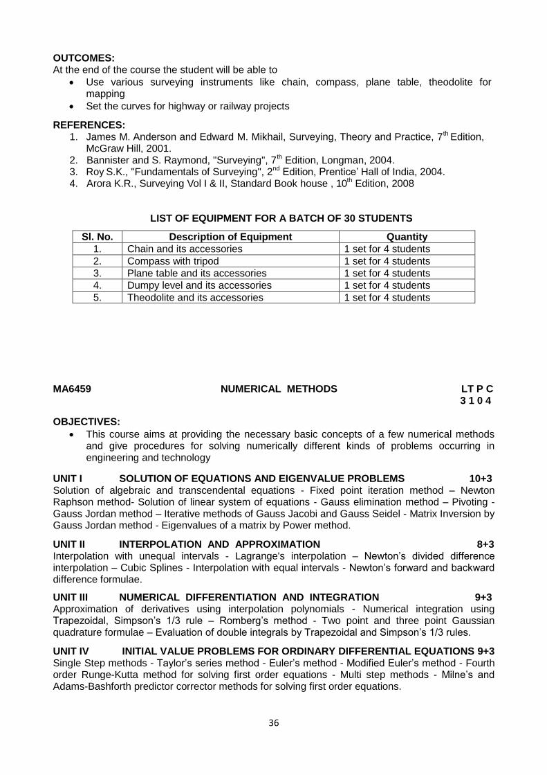
36
OUTCOMES: At the end of the course the student will be able to
Use various surveying instruments like chain, compass, plane table, theodolite for mapping
Set the curves for highway or railway projects
REFERENCES: 1. James M. Anderson and Edward M. Mikhail, Surveying, Theory and Practice, 7th Edition,
McGraw Hill, 2001. 2. Bannister and S. Raymond, "Surveying", 7th Edition, Longman, 2004. 3. Roy S.K., "Fundamentals of Surveying", 2nd Edition, Prentice‟ Hall of India, 2004. 4. Arora K.R., Surveying Vol I & II, Standard Book house , 10th Edition, 2008
LIST OF EQUIPMENT FOR A BATCH OF 30 STUDENTS
Sl. No. Description of Equipment Quantity
1. Chain and its accessories 1 set for 4 students
2. Compass with tripod 1 set for 4 students
3. Plane table and its accessories 1 set for 4 students
4. Dumpy level and its accessories 1 set for 4 students
5. Theodolite and its accessories 1 set for 4 students
MA6459 NUMERICAL METHODS LT P C 3 1 0 4
OBJECTIVES:
This course aims at providing the necessary basic concepts of a few numerical methods and give procedures for solving numerically different kinds of problems occurring in engineering and technology
UNIT I SOLUTION OF EQUATIONS AND EIGENVALUE PROBLEMS 10+3 Solution of algebraic and transcendental equations - Fixed point iteration method – Newton Raphson method- Solution of linear system of equations - Gauss elimination method – Pivoting - Gauss Jordan method – Iterative methods of Gauss Jacobi and Gauss Seidel - Matrix Inversion by Gauss Jordan method - Eigenvalues of a matrix by Power method.
UNIT II INTERPOLATION AND APPROXIMATION 8+3 Interpolation with unequal intervals - Lagrange's interpolation – Newton‟s divided difference interpolation – Cubic Splines - Interpolation with equal intervals - Newton‟s forward and backward difference formulae.
UNIT III NUMERICAL DIFFERENTIATION AND INTEGRATION 9+3 Approximation of derivatives using interpolation polynomials - Numerical integration using Trapezoidal, Simpson‟s 1/3 rule – Romberg‟s method - Two point and three point Gaussian quadrature formulae – Evaluation of double integrals by Trapezoidal and Simpson‟s 1/3 rules.
UNIT IV INITIAL VALUE PROBLEMS FOR ORDINARY DIFFERENTIAL EQUATIONS 9+3 Single Step methods - Taylor‟s series method - Euler‟s method - Modified Euler‟s method - Fourth order Runge-Kutta method for solving first order equations - Multi step methods - Milne‟s and Adams-Bashforth predictor corrector methods for solving first order equations.
37
UNIT V BOUNDARY VALUE PROBLEMS IN ORDINARY AND PARTIAL DIFFERENTIAL EQUATIONS 9+3
Finite difference methods for solving two-point linear boundary value problems - Finite difference techniques for the solution of two dimensional Laplace‟s and Poisson‟s equations on rectangular domain – One dimensional heat flow equation by explicit and implicit (Crank Nicholson) methods – One dimensional wave equation by explicit method.
TOTAL (L:45+T:15): 60 PERIODS
OUTCOMES:
The students will have a clear perception of the power of numerical techniques, ideas and would be able to demonstrate the applications of these techniques to problems drawn from industry, management and other engineering fields.
TEXTBOOKS: 1. Grewal. B.S., and Grewal. J.S. "Numerical methods in Engineering and Science",Khanna
Publishers, New Delhi, 9th Edition, 2007. 2. Gerald. C. F., and Wheatley. P. O., "Applied Numerical Analysis", Pearson Education,
Asia, New Delhi, 6th Edition, 2006.
REFERENCES: 1. Chapra. S.C., and Canale.R.P., "Numerical Methods for Engineers, Tata McGraw-Hill, New
Delhi, 5th Edition, 2007. 2. Brian Bradie. "A friendly introduction to Numerical analysis",Pearson Education, Asia, New
Delhi, 2007. 3. Sankara Rao. K.,"Numerical methods for Scientists and Engineers", Prentice Hall of India
Pvt. Ltd., New Delhi, 3rd Edition, 2007. GI6401 GEODETIC SURVEYING L T P C
2 2 0 4
OBJECTIVES:
This subject deals with geodetic measurements and Control Survey methodology.
To introduce the basics of Astronomical Surveying and
Practical Astronomy and its applications.
UNIT I LEVELLING 6+6 Level line - Horizontal line - Datum - Bench marks -Levels and staves - temporary and permanent adjustments – Methods of leveling - Fly levelling - Check levelling - Procedure in levelling - Booking -Reduction - Curvature and refraction - Reciprocal levelling - Precise levelling - Types of instruments - Adjustments - Field procedure- sources of errors.
UNIT II CONTOURING, AREA AND VOLUME COMPUTATION 6+6 Longitudinal and Cross-section-Plotting - Contouring - Methods - Characteristics and uses of contours – Plotting – Methods of interpolating contours The Planimeter - Areas enclosed by straight lines - Irregular figures - Volumes - Earthwork calculations - Capacity of reservoirs - Mass haul diagrams.
UNIT III CONTROL SURVEYING 6+6
Horizontal and vertical control- Methods- specifications - Triangulation- Base line - Instruments and
accessories – Corrections - Satellite station - Reduction to centre – Trigonometric levelling- Single and reciprocal observations - Traversing - Gale‟s table.
UNIT IV ASTRONOMICAL SURVEYING 6+6
Celestial sphere - Astronomical terms and definitions - Motion of sun - horizon, hour angle, right
ascension and ecliptic Celestial coordinate systems – Sidereal, universal, zone and atomic time systems - Nautical Almanac.
38
UNIT V PRACTICAL ASTRONOMY 6+6 Apparent altitude and corrections - Field observations and determination of time, longitude, Latitude and azimuth by altitude and hour angle method
TOTAL (L:30+T:30): 60 PERIODS OUTCOMES: At the end of the course the student will be able to understand
Concept of leveling and various methods used determination of level
The procedures involved in computation of area, volume and interpolation of contour
The methods used for establishment of horizontal and vertical control networks
Concepts of astronomical surveying and methods to determine time, longitude, latitude and azimuth
TEXTBOOKS: 1. Mansfield Merriman,” An Introduction of Geodetic Surveying “, Nabupress, 2010
2. Edward Richard Cary, “ Geodetic Surveying “NabuPress, 2011.
REFERENCES: 1. James M. Anderson and Edward M. Mikhail, "Surveying, Theory and Practice, 7th Edition,
McGraw Hill, 2001. 2. Bannister and S. Raymond, "Surveying, 7th Edition, Longman, 2004.
GI6402 OBJECT ORIENTEDPROGRAMMING FOR GEOINFORMATICS ENGINEERS LT P C 3 0 0 3 OBJECTIVES :
To facilitate the student to develop Object Oriented Programming
To Familiarize GIS customisation programming using Java and AJAX.
UNIT I CONCEPTS OF OBJECT ORIENTED PROGRAMMING 9 Principles - Abstract Data types - Inheritance - Polymorphism - Object Identity - Object Modeling -Object Oriented Programming Languages - Object Oriented Databases - Object Oriented user Interfaces - Object Oriented GIS - Object Oriented Analysis - Object Oriented Design –Examples.
UNIT II C++ PROGRAMMING FUNDAMENTALS 9 Introduction to C++- Keywords, Identifiers- Data types- Variables – Operators`-Manipulators-Operator Overloading- Operator Precedence- Control Statements-Functions - Call by Reference - Arguments - Function Overloading – Exercises
UNIT III CLASSES AND OBJECTS 9 Classes and Objects - Member Functions - Nesting of Member Functions Constructors -Destructors -Type Conversions - Inheritance - Base class - Derived Class - Visibility modes - Single Inheritance - Multilevel Inheritance - Multiple Inheritance - Nesting - Polymorphism - File -Opening and Closing – Exercises
UNIT IV JAVA PROGRAMMING 9 Java – C++ comparison – Java and portability – Java beans and events – Servlet – applets – package – interface – implementation – class hierarchies in Java- Polymorphism and inheritance – data hiding concepts- Java client and server side pages - Customization in GIS.
UNIT V SCRIPTS AND OOP 9 AJAX - Introduction – history – libraries - Struts – JSF – Hibernate – Spring – AJAX Programming – Java scripts - Python and Perl- Customization in GIS.
TOTAL : 45 PERIODS
39
OUTCOMES: At the end of the course the student will be able to understand
Concepts of Object Oriented programming techniques
the tools and procedure involved in programming with C++, Java
concepts of various scripting languages and their use in GIS customization
TEXTBOOKS: 1. Balagurusamy. E., Object Oriented Programming with C++, 4th edition, Tata McGraw Hill
Publications, 2008 2. Daniel Liang, "Introduction to Java Programming", 6th Edition, 2010
REFERENCES: 1. Bjarne Stroustrup, "Programming: Principles and Practice" using C++, Ist Edition, Addison
Wesley Publications, 2008. 2. Ponnambalam.P and Tiuley Alguindigue, “A C++ Primer for Engineers: An Object
Oriented approach” , McGraw Hill, 1997 3. Kris Hadlock, Ajax for Web application developers, Ist edition, Sams Publishing, 2006 4. Bhushan Trivedi, “Programming with ANSI C++ A Step by step approach
“OxfordUniversity Press, 2010
Web Resources 1. http://docs.oracle.com/javaee/5/tutorial/doc 2. www.cplusplus.com/doc/tutorial/
GI6403 ADVANCED PHOTOGRAMMETRY L T P C 3 0 0 3 OBJECTIVES:
To introduce the principle and concepts of Interior, Relative and Absolute Orientation for mapping using Stereo plotters and basics of Digital and Non-topographic photogrammetry
UNIT I AERIAL TRIANGULATION PRINCIPLES AND ADJUSTMENTS 9 Basic concepts of strips and blocks photographic aerial triangulation - Analog triangulation- Independent Model Triangulation - Strip formation, graphical strip adjustment-polynomial strip adjustment - Analytical aerial triangulation, adjustment of blocks of aerial photographs- Three- dimensional coordinate transformation.
UNIT II NON TOPOGRAPHIC PHOTOGRAMMETRY 9 Applications - terrestrial cameras - stereometric cameras - horizontal and vertical angles from terrestrial photographs - Camera azimuth - analytical determination of horizontal position of a point from Photographic measurement - graphical method– use of plotting equipments - control consideration for terrestrial Photogrammetry - X-ray Photogrammetry. UNIT III DIGITAL CAMERAS, SCANNERS & WORKSTATIONS 9 Representation of Images- Cameras – Technology of CCD- types of scanners- typical photogrametric Scanner – image Geometry & Radiometry – stereo viewing – stereo W/S requirements – Photogrametric functionalities- quality checks. UNIT IV DIGITAL IMAGE HANDLING 9 Image Generation – epipology geometry - data Compressions – formats – Image pyramids- sub-band coding – scaline functions image matching Techniques – template, correlation – statistical - Geometry, texture based – decision theoretic methods – string matching – trees image measurements – single library.
40
UNIT V PHOTOGRAMMETRIC PRODUCTS AND APPLICATIONS 9 DEM, DTM, DSM- Representation of DEM generation from visible images – point matching – quality factors and checking – DEM correction – DSM generation – DTM characteristic features- relief characteristics- orthophoto generation – feature extraction – satellite stereo missions and products.
TOTAL : 45 PERIODS OUTCOMES: At the end of the course the student will be able to understand
The concepts and procedure involved in aerial triangulation
The methods and applications of terrestrial photogrammetry
The components and characteristics of digital cameras, scanners
The techniques used for handling digital data and generation of DEM,DTM, orthophoto
TEXTBOOKS: 1. Alex Alvarez, Reg Downing , “Image Based Modeling : Advanced 3D Modelling from
Panoramas, 2005 2. Wilfried Linder, Digital Photogrammetry, A Practical Course 3rd edition, 2009.
REFERENCES : 1. Paul. R Wolf, Bon A.DeWitt, Elements of Photogrammetry with application in GIS-
McGraw Hill International Book Co., 3rd Edition, 2000 2. E.M.Mikhail, J.S.Bethel, J.C.McGlone, Introduction to Modern Photogrammetry, Wiley
Publisher, 2001 3. Gollfried Konecny, Geoinformation: Remote Sensing, Photogrammetry and Geographical
Information Systems, CRC Press, 1st Edition, 2002 4. American Society of Photogrammetry and Remote Sensing, 4th Edition, 2013
GI6404 OPTICAL AND THERMAL REMOTE SENSING L T P C 3 0 0 3
OBJECTIVES :
To introduce the concepts of remote sensing processes and its components.
To expose the various remote sensing platform and sensors and to introduce the elements of data interpretation
UNIT I REMOTE SENSING AND ELECTROMAGNETIC RADIATION (EMR) 9 Definition - components – History- EMR Specification- wave theory, particle theory- radiation sources and quantities – Atmospheric region and characteristics- Atmospheric windows – scattering (Rayleigh, Mie, non-selective scattering) Radiative transfer & volume Scattering- Lamella pack – absorption & transmittance – EM Interaction with various earth elements – spectral signature – interpretation elements
UNIT II PLATFORMS AND SENSORS AND DATA PRODUCTS 9 Ground Space based platform – SUN and Geosynchronous orbits – sensors for EM Spectra - Orbital & Sensor characteristics – Calibration- International Satellite Mission - high resolution satellite sensors- „Step & Stare‟ and Time Delay Integration mode - Hardcopy and digital data Products - stereo satellite data products – Indian Remote Sensing Program
UNIT III THERMAL REMOTE SENSING 9 Thermal radiation principles – Thermal interaction sensors and characters – thermal image characters – image degradation sources & correction – interpretation of thermal images – Application and Case studies.
41
UNIT IV HYPERSPECTRAL REMOTE SENSING 9
Diffraction principles - field spectrum – BDRF and spectral reflectance & imaging spectrometry -
sensors - virtual dimensionality – Data reduction, Calibration and normalization – Huge‟s phenomenon - Data Characteristics Binary encoding- thresholding - library matching.
UNIT V LIDAR 9 LIDAR – Principles and Properties- different LIDAR System- Space Borne and airborne LIDAR missions – Typical parameters of LIDAR system. Data Processing – geometric correction- data quality enhancement – filtering LIDAR mapping applications – hydrology, Disaster mitigation and management
TOTAL: 45 PERIODS OUTCOMES: At the end of the course the student will be able to understand
The characteristics of electromagnetic radiation and its interaction with earth features
The types and configuration of various satellites and sensors
The concepts of thermal and hyperspectral remote sensing and their applications
The concept, processing of LIDAR and its applications
TEXTBOOKS: 1. Richards, " Remote sensing digital Image Analysis-An Introduction Springer" - Verlag
1993. 2. Lillesand, T.M. and Kiefer R.W. "Remote Sensing and Image interpretation", John Wiley
and Sons, Inc, New York, 2002.
REFERENCES: 1. Janza, F.Z., Blue H.M. and Johnson,J.E. "Manual of Remote Sensing. Vol.I, American Society of Photogrametry, Virginia, USA, 2002. 2. Verbyla, David, "Satellite Remote Sensing of Natural Resources". CRC Press, 1995 3. Paul Curran P.J. "Principles of Remote Sensing". Longman, RLBS, 2003.
GE6351 ENVIRONMENTAL SCIENCE AND ENGINEERING L T P C
3 0 0 3
OBJECTIVES: To the study of nature and the facts about environment.
To finding and implementing scientific, technological, economic and political solutions to environmental problems.
To study the interrelationship between living organism and environment.
To appreciate the importance of environment by assessing its impact on the human world; envision the surrounding environment, its functions and its value.
To study the dynamic processes and understand the features of the earth‟s interior and surface.
To study the integrated themes and biodiversity, natural resources, pollution control and waste management.
UNIT I ENVIRONMENT, ECOSYSTEMS AND BIODIVERSITY 12 Definition, scope and importance of Risk and hazards; Chemical hazards, Physical hazards, Biological hazards in the environment – concept of an ecosystem – structure and function of an ecosystem – producers, consumers and decomposers-Oxygen cycle and Nitrogen cycle – energy flow in the ecosystem – ecological succession processes – Introduction, types, characteristic features, structure and function of the (a) forest ecosystem (b) grassland ecosystem (c) desert ecosystem (d) aquatic ecosystems (ponds, streams, lakes, rivers, oceans, estuaries) – Introduction to biodiversity definition: genetic, species and ecosystem diversity – biogeographical classification of India – value of biodiversity: consumptive use, productive use, social, ethical,
42
aesthetic and option values – Biodiversity at global, national and local levels – India as a mega-diversity nation – hot-spots of biodiversity – threats to biodiversity: habitat loss, poaching of wildlife, man-wildlife conflicts – endangered and endemic species of India – conservation of biodiversity: In-situ and ex-situ conservation of biodiversity. Field study of common plants, insects, birds Field study of simple ecosystems – pond, river, hill slopes, etc.
UNIT II ENVIRONMENTAL POLLUTION 10 Definition – causes, effects and control measures of: (a) Air pollution (Atmospheric chemistry- Chemical composition of the atmosphere; Chemical and photochemical reactions in the atmosphere - formation of smog, PAN, acid rain, oxygen and ozone chemistry;- Mitigation procedures- Control of particulate and gaseous emission, Control of SO2, NOX, CO and HC) (b) Water pollution : Physical and chemical properties of terrestrial and marine water and their environmental significance; Water quality parameters – physical, chemical and biological; absorption of heavy metals - Water treatment processes. (c) Soil pollution - soil waste management: causes, effects and control measures of municipal solid wastes – (d) Marine pollution (e) Noise pollution (f) Thermal pollution (g) Nuclear hazards–role of an individual in prevention of pollution – pollution case studies – Field study of local polluted site – Urban / Rural / Industrial / Agricultural. UNIT III NATURAL RESOURCES 10 Forest resources: Use and over-exploitation, deforestation, case studies- timber extraction, mining, dams and their effects on forests and tribal people – Water resources: Use and overutilization of surface and ground water, dams-benefits and problems – Mineral resources: Use and exploitation, environmental effects of extracting and using mineral resources, case studies – Food resources: World food problems, changes caused by agriculture and overgrazing, effects of modern agriculture, fertilizer-pesticide problems, water logging, salinity, case studies – Energy resources: Growing energy needs, renewable and non renewable energy sources, use of alternate energy sources. Energy Conversion processes – Biogas – production and uses, anaerobic digestion; case studies – Land resources: Land as a resource, land degradation, man induced landslides, soil erosion and desertification – role of an individual in conservation of natural resources – Equitable use of resources for sustainable lifestyles. Introduction to Environmental Biochemistry: Proteins –Biochemical degradation of pollutants, Bioconversion of pollutants. Field study of local area to document environmental assets – river / forest / grassland / hill / mountain.
UNIT IV SOCIAL ISSUES AND THE ENVIRONMENT 7 From unsustainable to sustainable development – urban problems related to energy – water conservation, rain water harvesting, watershed management – resettlement and rehabilitation of people; its problems and concerns, case studies – role of non-governmental organization- environmental ethics: Issues and possible solutions – 12 Principles of green chemistry- nuclear accidents and holocaust, case studies. – wasteland reclamation – consumerism and waste products – environment production act – Air act – Water act – Wildlife protection act – Forest conservation act –The Biomedical Waste (Management and Handling) Rules; 1998 and amendments- scheme of labeling of environmentally friendly products (Ecomark). enforcement machinery involved in environmental legislation- central and state pollution control boards- disaster management: floods, earthquake, cyclone and landslides. Public awareness.
UNIT V HUMAN POPULATION AND THE ENVIRONMENT 6 Population growth, variation among nations – population explosion – family welfare programme – environment and human health – human rights – value education – HIV / AIDS – women and child welfare –Environmental impact analysis (EIA)- -GIS-remote sensing-role of information technology in environment and human health – Case studies.
TOTAL : 45 PERIODS
43
OUTCOMES: Environmental Pollution or problems cannot be solved by mere laws. Public participation is an important aspect which serves the environmental Protection. One will obtain knowledge on the following after completing the course.
Public awareness of environmental is at infant stage.
Ignorance and incomplete knowledge has lead to misconceptions
Development and improvement in std. of living has lead to serious environmental disasters
TEXTBOOKS : 1. Gilbert M.Masters, „Introduction to Environmental Engineering and Science‟, 2nd edition,
Pearson Education,2004 2. Benny Joseph, „Environmental Science and Engineering‟, Tata McGraw Hill, New Delhi,
2006.
REFERENCES : 1. Trivedi R.K. „Handbook of Environmental Laws, Rules, Guidelines, Compliances and
Standards‟, Vol.I and II, Enviro Media. 2. Cunningham, W.P.Cooper., T.H. Gorhani, „Environmental Encyclopedia‟,Jaico Publishing
House, Mumbai, 2001. 3. Dharmendra S. Sengar, „Environmental law‟, Prentice hall of India Pvt Ltd, New Delhi,2007. 4. Rajagopalan, R, „Environmental Studies - From Crisis to Cure‟, Oxford University Press,
2005
GI6411 OBJECT ORIENTED PROGRAMMING LABORATORY L T P C 0 0 4 2
OBJECTIVES :
To implement different concepts of Object Oriented Programming using C++
Hands on exercise on various OOPs concepts using C++.
To implement GIS customization using scripting language
LIST OF EXPERIMENTS:
Arithmetic operations
Control structures
Graphic Libraries
Matrix manipulation and functions
Operator Overloading – binary and unary operators as friend and member functions
Unary operator - Prefix and Postfix form
Nesting of member functions
Constructors, Destructors
Constructor Overloading
Inheritance and its forms
Visibility mode – public, private and protected
Runtime Polymorphism – Virtual functions
File opening and file closing
GIS customization using Scripting language
GIS customization using Scripting language TOTAL : 60 PERIODS
OUTCOMES: At the end of the course the student will be able to develop
Programs using C++ language
Codes implementing various Object oriented concepts
Scripts using Java and AJAX
44
REFERENCE : 1. Bjarne Stroustrup, Programming: Principles and Practice using C++, Ist Edition, Addison
Wesley Publications, 2008.
LIST OF EQUIPMENT FOR A BATCH OF 30 STUDENTS
Sl. No. Description of Equipment Quantity
1. Computer 1 for 2 students
2. License software required to teach C++ and GIS
minimum 5 licenses each
GI6412 ADVANCED PHOTOGRAMMETRY LABORATORY L T P C 0 0 4 2
OBJECTIVES:
To acquire knowledge about Interior, Relative and Absolute Orientation using Analog and Analytical Stereo plotters.
LIST OF EXPERIMENTS: 1. Digital Photogrammetric Workstation - Data input and Creation of Project 2. Image import - Image Enhancement 3. Control point editing 4. Camera Calibration - Automatic and Manual Interior Orientation 5. Orientation Management - Camera Calibration - Editing the Scheme point file
6. Imagery import - Relative Orientation - Absolute Orientation 7. ATM Adjustment - Automatic Point Measurement 8. DEM,DTM generation - Correction and Analysis, Mosaic & Feature extraction, Automatic
Terrain Extraction 9. Editing the DTM 10. DTM Terrain analysis 11. Mosaic - Generating Orthophoto - Mosaic sheet cutting 12. Planimetric Mapping
TOTAL: 60 PERIODS
OUTCOMES: At the end of the course the student will be able to
Produce Orthophoto, DTM from digital photographs using DPW
Produce planimetric maps from stereomodels using DPW
REFERENCE : 1. Paul. R Wolf, Bon A.Dewitt, "Elements of Photogrammetry with application" in GIS 3rd
Edition, McGraw Hill International Book Co., 2000.
LIST OF EQUIPMENT FOR A BATCH OF 30 STUDENTS
Sl. No.
Description of Equipment Quantity
1. Digital photogrammetric workstation 2 nos
2. License software minimum 2 user license
45
GI6413 GEODETIC SURVEYING LABORATORY L T P C 0 0 4 2
OBJECTIVES:
The objective of this course is to train the students to acquire skills in making precise measurements and obtaining accurate results.
LIST OF EXPERIMENTS:
I. LEVELLING 32
Taking spot levels
Fly levelling using Dumpy level
Fly levelling using Tilting level
Check levelling
Permanent adjustment of levels
Contouring
LS and CS
Computation of volume of earth work from contours
II. FIELD ASTRONOMY
Study of motion of the Sun
Determination of azimuth using known latitude
Determination of azimuth using hour angle
Determination of watch error
Determination of latitude
20
III. ESTABLISHMENT OF BASELINE
4
IV.
THEODOLITE TRAVERSING
4
TOTAL: 60 PERIODS
OUTCOMES: At the end of the course the student will be able to
Observe level differences between stations using different types of leveling techniques
Compute area, volume of earthwork from levels
Determine azimuth, latitude and time from astronomical observations
REFERENCE: 1. James M. Anderson and Edward M. Mikhail, Surveying, Theory and Practice, 7th Edition,
McGraw Hill, 2001.
LIST OF EQUIPMENT FOR A BATCH OF 30 STUDENTS
Sl. No.
Description of Equipment Quantity
1. Dumpy Level with accessories 1 set for 4 students
2. Theodolite with accessories 1 set for 4 students
3. Tilting level with accessories 1 set for 4 students
GI6501 GEO DATABASE SYSTEM L T P C 3 0 0 3
OBJECTIVES:
To introduce the students to the concepts of DBMS, Spatial Database Management System (SDBMS), Spatial Database design, basic application program development and user interfaces.
46
UNIT I INTRODUCTION 9 Data – Information - File system vs DBMS – Database Management Systems – Database Architectures, users and administrators – Classification of Database Management Systems - Spatial Data- Points, Lines, Polygons- definition of SDBMS -user classes of SDBMS - Multi layer architecture of SDBMS - GIS and SDBMS
UNIT II SPATIAL CONCEPTS AND DATAMODELS 10 Field based model – object based model – spatial data types – operations on spatial objects- Entity Relationship Model (ER Model) – Relational Model – Constraints and Normal forms of Relational Model - mapping ER model to Relational model – ER model with spatial concepts – Object-oriented data modeling with Unified Modeling Language (UML)
UNIT III QUERY LANGUAGE 9 SQL – Data Definition – Data Manipulation - Basic structure of SQL – Set operations –Aggregate Functions –Simple queries –spatial vs non spatial- Nested sub queries – Complex queries – Views – Trigger - OGIS standard for extending SQL - example spatial SQL queries – Object relational SQL.
UNIT IV SPATIAL STORAGE AND INDEXING 9 Disk geometry – Buffer manager –Field-Record – File – File Structure – Clustering -Basic concepts of file organizations, indexing – Spatial Indexing – Grid files – R Tree – Concurrency support – Spatial Join index - Database recovery techniques – Database Security.
UNIT V SPATIAL DATABASE SYSTEMS AND APPLICATION DESIGN AND DEVELOPMENTS 8 Exploring Spatial Geometry, Organizing spatial data, spatial data relationships and functionalities of any one commercial and one FOSS DBMS each – Application program and user Interfaces.
TOTAL: 45 PERIODS OUTCOMES: At the end of the course the student will be able to understand
Concepts and architecture of SDBMS
Concepts of SQL and generation of queries
Concepts of spatial data storage and design of SDBMS
TEXTBOOKS: 1. Shashi Shekhar, Sanjay Chawla,”Spatial Databases a Tour” Prentice Hall, 2003. 2. Philippe Rigaux, Michel Scholl, Agnès Voisard “Spatial Databases” Morgan Kaufmann,
2001
REFERENCES: 1. Abraham Silberschatz, Henry F. Korth and S.Sudharshan, “Database System Concepts”,
6th edition, McGraw Hill, 2011 2. Ravi Kothuri, Albert Godfrind, Euro Beinat “Pro Oracle Spatial for Oracle Database 11g”,
Apress , 2007 3. Regina, Leo Hsu “Post GIS in Action”, Oreilly & Associates Inc., 2011
GI6502 GEODESY L T P C 2 2 0 4
OBJECTIVES:
To understand the geometry of the earth and its relationship with nature.
UNIT I FUNDAMENTALS OF GEODESY 6 Definitions- Classifications, Problem of Geodesy and purpose of Geodesy Historical development and Organization of Geodesy. Reference Surfaces and their relationship. Applications - Engineering, Lunar and Planetary Geodesy - Interferometric Synthetic aperture radar Geodesy – Local and International Spheroid.
47
UNIT II GEOMETRIC GEODESY 6 Geomentry of ellipsoid, fundamental mathematical relationship of ellipsoid, Geodetic, Geocentric and Reduced latitudes and their relationship. Ellipsoidal Co-ordinates in terms of Reduced, Geodetic and geocentric latitude. Radius of curvature in the meridian & prime vertical and their relationship. Mean Radius of curvature in any azimuth, Length of the meridian arcs and arcs of parallel and Area of trapezium on the ellipsoid. Curves on the ellipsoid, properties of Geodesic.
UNIT III CO-ORDINATE SYSTEMS 6 Natural or Astronomical Co-ordinate System, Geodetic or Geographical co-ordinate System, Rectangular or Cartesian Co-ordinate System and relationship between them. Curvilinear Co-ordinate System. Deflection of Vertical, Spherical excess. Astro-Geodetic method of determining the reference Spheroid.
UNIT IV PHYSICAL GEODESY 6 Basics - INGN -the significance of gravity measurements, Gravity field of earth, Concept of equipotential, Geo potential and Sphero potential Surface - Normal gravity and its computations, Methods of measuring Absolute and Relative gravity- Gravimeters-Reduction of gravity measurements, terrain and Isostasy corrections. Gravity networks. Gravity anomaly and Gravity disturbance-Fundamental equation of Physical Geodesy. Gravimetric determination of Geoid and Deflection of Vertical UNIT V GEODETIC ASTRONOMY 6 Celestial coordinates systems and its relationship with Cartesian Co-ordinates and Transformation between them -Special star positions, Major constellations- time systems (sidereal, Universal , atomic and standard ) rising and setting of Stars with respect to Declination, hour angle and Azimuth, Culmination, Prime Vertical Crossing and Elongation.
TOTAL (L:30+T:30): 60 PERIODS
OUTCOMES: At the end of the course the student will be able to understand
Various fundamentals of Geodesy
Concepts of geoid, ellipsoid and their interrelationship
Various types of coordinate systems and relationship between them
The methods for measurement of gravity and gravity network
The concepts of astronomical observations for determination geodetic parameters TEXTBOOKS:
1. Wolfgang Torge, Geodesy, Walter De Gruyter Inc., Berlin, 2001. 2. Guy Bomford” Geodesy” Nabu Press, 2010,
REFERENCES: 1. Petr Vanicek and Edward J. Krakiwsky, Geodesy: The concepts, North-Holland
Publications Co., Amsterdam, 1991. 2. Tom Herring, “Geodesy „ Elsevier,2009, 3. Schwarze, V.S. Geodesy: The challenge of the 3rd millennium, Springer verlag,
2002. 4. James R.Smith, "Introduction to Geodesy", John wiley & Sons Inc. 1997.
GI6503 DIGITAL IMAGE PROCESSING FOR GEOINFORMATICS ENGINEERS LT P C 3 0 0 3 OBJECTIVES:
To make the undergraduate Engineering Students understand the concepts, principles, processing of Satellite data in order to extract useful information from them.
48
UNIT I FUNDAMENTALS OF IMAGE PROCESSING 9 Information Systems - Encoding and decoding - acquisition, storage and retrieval –data products-Digital Image Processing Systems - Hardware and software design consideration Scanner, digitizer - photo write systems.
UNIT II SENSOR MODELS AND PRE PROCESSING 9 Image Fundamentals – Sensor models – spectral response – Spatial response – IFOV,GIFOV & GSI – Simplified Sensor Models – Sampling & quantization concepts – Image Representation & geometry and Radiometry – Colour concepts – Sources of Image degradation and Correction procedures- Atmospheric Radiometric, Geometric Corrections- Image Geometry Restoration- Interpolation methods and resampling techniques.
UNIT III IMAGE ENHANCEMENT 9 Image Characteristics - Histograms - Scatter grams – Univariate and multi variate statistics-
enhancement in spatial domain – global, local & colour Transformations – PC analysis, edge
detections, merging- filters- convolution – LPF, HPF , HBF, directional box, cascade – Morphological and adaptive filters – Zero crossing filters – scale space transforms – power spectrum – texture analysis - Fourier Transformations- inverse transformations wavelet & curvelet transformations. UNIT IV IMAGE CLASSIFICATION 9 Spectral discrimination - pattern recognition concepts - Baye‟s approach - Signature and training sets – Separability test – parametric and non parametric classifiers – Segmentation (Spatial, Spectral)- Fuzzy set classification , member ship function and de-fuzzifications – sub-pixel classifier- hybrid classifiers - accuracy assessment – error matrix – Kappa statistics – ERGAS, RMS etc.,
UNIT V OBJECT RECOGNITION 9 Morphological operators - descriptors - representation schemes – Compressions- Image matching, template, correlation, texture based operators, Geometry operators- Artificial Neural nets - Expert system, types and examples - Knowledge systems- representation knowledge handling – decision making paradigms.
TOTAL : 45 PERIODS
OUTCOMES: At the end of the course the student will be able to understand
Various components and characteristics of image processing systems
The concepts of image geometry and radiometry and corrections
Various types of image enhancement techniques used for satellite image processing
The concepts of Image classification and use of various classifiers
Various object recognisation techniques available for extraction of features
TEXTBOOKS: 1. John, R. Jensen, "Introductory Digital Image Processing", 3rd edition, Prentice Hall, New
Jersey, 2005 2. Robert, A. Schowengergt, "Techniques for Image Processing and classification in
RemoteSensing", 1983.
REFERENCES: 1. Robert, G. Reeves,- " Manual of Remote Sensing Vol. I & II - American Society of
Photogrammetry, Falls, Church, USA, 1983. 2. Richards, " Remote sensing digital Image Analysis - An Introduction Springer -
Verlag1993. 3. Rafael C. Gonzalez and Richard Eugene Woods "Digital Image Processing, Pearson/
Prentice Hall, 2008 4. Annadurai.S, "Fundamentals of Digital Image Processing Pearson Education, 2007
49
GI6504 GEOGRAPHIC INFORMATION SYSTEM L T P C 3 0 0 3
OBJECTIVES:
To introduce the fundamentals and components of Geographic Information System
To provide details of spatial data structures and input, management and output processes.
UNIT I FUNDAMENTALS OF GIS 9 Introduction to GIS - Basic spatial concepts - Coordinate Systems - GIS and Information Systems – Definitions – History of GIS - Components of a GIS – Hardware, Software, Data, People, Methods – Proprietary and open source Software - Types of data – Spatial, Attribute data- types of attributes – scales/ levels of measurements.
UNIT II SPATIAL DATA MODELS 9 Database Structures – Relational, Object Oriented – Entities – ER diagram - data models- conceptual, logical and physical models - spatial data models – Raster Data Structures – Raster Data Compression - Vector Data Structures - Raster vs Vector Models- TIN and GRID data models.
UNIT III DATA INPUT AND TOPOLOGY 9 Scanner - Raster Data Input – Raster Data File Formats – Georeferencing – Vector Data Input –Digitiser – Datum Projection and reprojection -Coordinate Transformation – Topology - Adjacency, connectivity and containment – Topological Consistency – Non topological file formats - Attribute Data linking – Linking External Databases – GPS Data Integration
UNIT IV DATA QUALITY AND STANDARDS 9 Data quality - Basic aspects - completeness, logical consistency, positional accuracy, temporal accuracy, thematic accuracy and lineage – Metadata – GIS Standards – Interoperability - OGC - Spatial Data Infrastructure
UNIT V DATA MANAGEMENT AND OUTPUT 9 Import / Export – Data Management functions - Raster to Vector and Vector to Raster Conversion -Data Output - Map Compilation – Chart/Graphs – Multimedia – Enterprise Vs. Desktop GIS- distributed GIS.
TOTAL: 45 PERIODS OUTCOMES: At the end of the course the student will be able to understand
The basic concepts and components of GIS
The techniques used for storage of spatial data and data compression
The practices used for input, management and output of spatial data
Concepts of spatial data quality and data standards
TEXTBOOKS: 1. Kang-Tsung Chang, " Introduction to Geographic Information Systems", 2nd Edition,
McGraw Hill Publishing, 2011. 2. Ian Heywood, Sarah Cornelius, Steve Carver, Srinivasa Raju, “An Introduction
Geographical Information Systems, 2nd Edition, Pearson Education, 2007.
REFERENCE: 1. Lo Albert C.P. Yeung K.W. Concepts and Techniques of Geographic Information
Systems, Prentice Hall of India Publishers, 2006
GI6505 MICROWAVE REMOTE SENSING L T P C 3 0 0 3
OBJECTIVES:
To impart the knowledge in Microwave Remote Sensing and its application.
50
UNIT I FUNDAMENTALS AND ACTIVE SYSTEM 9 Introduction-Plane waves-Interference, Radar remote sensing - Radar basics- Antenna Systems -Real aperture radar - Radar frequency bands - SLAR Imaging Geometry, Resolution Concepts - Geometric Distortions, SAR – Concepts - Doppler principle & Processing. RADAR Interaction with earth surface- RADAR equation.
UNIT II MEASUREMENT AND DISCRIMINATION 9 Measurement and discrimination – sensors and target parameters- Surface Scattering – Dependence on Roughness - dependence on dielectric constant, Simple physical scattering models, Volume Scattering- Penetration depth - Volume scattering behavior of earth features, Speckle reduction.
UNIT III SPECIAL TOPICS 9 SAR Interferometry-Basics- Differential SAR Interferometry-applications polarimetry- Introduction - Polarization Ellipse - Polarization types –- Synthesis and signatures – Polarimetric parameters- Information extraction – Polarimetric Image Interpretation and applications. Altimetry - Principle – Frequency bands – Location Systems- missions, Scatterometry- Scatterometer types and calibration.
UNIT IV SAR SENSORS & APPLICATIONS OF RADAR 9 Airborne, Space borne – different platforms and sensors- History- ENVISAT, ASAR, ALOS / PALSAR- RADARSAT missions.- SAR Data products and selection procedure - Applications in Agriculture- Forestry - Geology –Hydrology - Ice Studies - Landuse- landcover mapping – Ocean related studies.
UNIT V PASSIVE SYSTEM 9 Radiometry- Passive microwave sensing components - Blackbody radiation and Greybody radiation – Emissivity, Radiometers – Components - Brightness temperature - Antenna temperature - Power-temperature correspondence, passive microwave interaction with atmospheric constituents - Emission characteristics of various earth features – Data products and Applications - Passive missions-DMSP, TRMM, Aqua missions, AMSR-E.
TOTAL: 45 PERIODS
OUTCOMES: At the end of the course the student will be able to understand
The fundamentals of microwave remote sensing systems like SLAR, SAR and RAR
The concepts of Interferometry, Polarimetry, Altimetry and Scatterometer
Different satellite systems and sensors used in microwave remote sensing with their applications
Concepts of passive microwave systems and applications
TEXTBOOKS: 1. Ulaby, F.T., Moore, R.K, Fung, A.K, "Microwave Remote Sensing; active and passive,
Vol. 1,2 and 3, Addison - Wesley publication company, 2001 2. Floyd, M., Handerson and Anthony J. Lewis, " Principles and application of Imaging
RADAR, Manual of Remote Sensing, 3rd edition, Vol.2, ASPRS, John Wiley and Sons Inc., 1998
REFERENCE: 1. Woodhouse lain. H, "Introduction to Microwave Remote Sensing" Taylor & Francis, 2005.

51
GI6506 SURVEY ADJUSTMENT L T P C 3 0 0 3
OBJECTIVES:
To impart skills in survey calculation and adjustment to suit field conditions
UNIT I MEASUREMENT AND ERROR 9 Concepts of measurement and Error - Types of errors - Elementary concepts in probability- Reliability of measurement - significant figures - Error Propagation- linearisation - Multivariate distribution - Error ellipse- Weights and cofactors - Non-linear stochastic variables.
UNIT II GENERAL ADJUSTMENT METHODS 9 Introduction - simple adjustment methods - Least squares method - Examples of least squares problems, Level net, triangulation figure adjustment, traverse adjustment.
UNIT III LEAST SQUARES ADJUSTMENT TECHNIQUES 9 Techniques of least squares- concept of weight - least squares adjustment of indirect Observations - least squared adjustment of observations only- adjustment of Trisection.
UNIT IV ELEMENTARY PROBABILITY THEORY 9 Random events and probability - Random variables - continuous probability distributions- normal distribution - Expectation - measures of precision and accuracy - covariance and correlation, covariance, cofactor and weight matrices - Introduction to sampling.
UNIT V VARIANCE COVARIANCE PROPAGATION 9 Introduction - Derivation of the propagation laws - Examples - stepwise propagation propagation of least squares - adjustment of indirect observations.
TOTAL: 45 PERIODS
OUTCOMES: At the end of the course the student will be able to understand
The concepts of error, error distribution and error adjustment procedures
The procedure involved in error adjustment using least square adjustment, elementary probability theory and variance covariance propagation
TEXTBOOKS : 1. Mikhail, E.M. and Gracie G., Analysis and adjustment of Survey measurements, Van
Nostrand Reinhold, New York, 2005 2. Bannister A. and Raymond B., “Surveying”, ELBS edition, 2006. 3. Bannister A. and Raymond B., “Solving problems in surveying”, ELBS edition, 2006.
REFERENCE: 1. Paul.R.Wolf and Charles. D.Ghilani, Adjustment Computations - Statistics and least
squares in surveying and GIS, John Wiley and sons inc., 1996.
GI6511 DIGITAL IMAGE PROCESSING LABORATORY L T P C 0 0 4 2
OBJECTIVES:
To familiarize the undergraduate level students in the regular Image Processing Software with respect to basic processing required to generate thematic maps from Satellite data.
LIST OF EXPERIMENTS:
1. Study of image file formats and organization
2. Enhancement of image 3. Filters & edge enhancement 4. Band rationing and NDVI
52
5. Principle Component Analysis (PCA) 6. Mosaic & subset 7. Geo-reference : Image to map & Image to Image 8. Training Set Generation & Analysis 9. Reprojection to different co-ordinate systems 10. Classification : Supervised & unsupervised
11. Accuracy Assessment 12. Classification improprement / Sub –pixel classification
13. Vector conversion and layer manipulation 14. Creation of cartographic elements and presentation 15. Map Layout preparation
TOTAL : 60 PERIODS
OUTCOMES: At the end of the course the student will be able to
Enhance satellite imagery through filtering, band ratioing, PCA etc
Georeference and project satellite imagery
Classify and assess accuracy of classification
REFERENCE: 1. Richards J.A, "Remote sensing digital Image Analysis - An Introduction Springer - Berlin
1993.
LIST OF EQUIPMENT FOR A BATCH OF 30 STUDENTS
Sl. No. Description of Equipment Quantity
1. Computer 1 system for 2 students
2. Licensed Digital Image Processing Software minimum 5 user license
GI6512 GEOGRAPHIC INFORMATION SYSTEM LABORATORY L T P C 0 0 4 2
OBJECTIVES:
To provide practical and hands on experience on Data Input, Data Management and Data Presentation capabilities of GIS
LIST OF EXPERIMENTS : 1. Data Input – Onscreen Digitisation – Creation of Point, Line and Polygon layers 2. Defining Projection, Datum and Coordinate System
3. Reprojection of Maps. 4. Attribute data input. 5. Measurement of Distance, Area 6. Coordinate Transformation 7. Tabular Data Analysis using SQL commands 8. Generating Charts from Tabular data 9. Linking External Database 10. Data Conversion – Vector to Raster 11. Data Conversion – Raster to Vector 12. Data Interchange – Conversion to interchange formats 13. Map Compilation for Point, Line and Polygon data 14. Map Joining and Edge Matching 15. Map Layout Design.
TOTAL: 60 PERIODS
OUTCOMES: At the end of the course the student will be able to
Create spatial database and nonspatial databases in GIS environment
Analyse spatial database and generate reports, maps
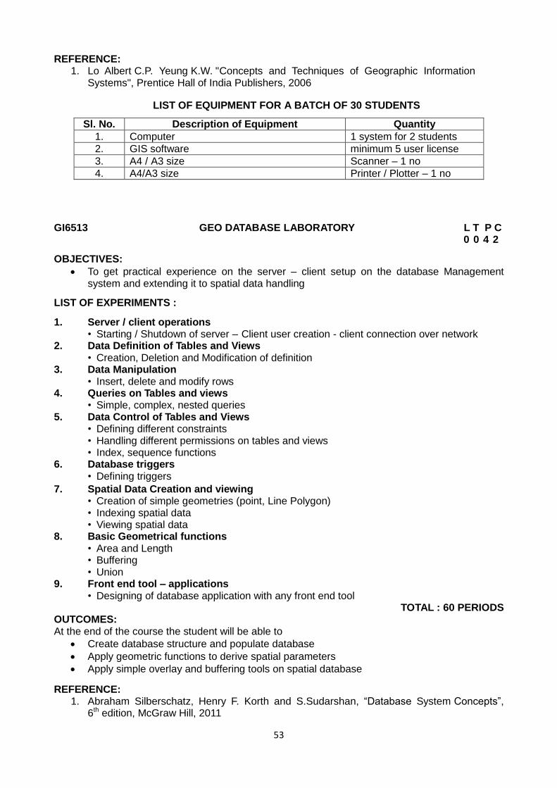
53
REFERENCE: 1. Lo Albert C.P. Yeung K.W. "Concepts and Techniques of Geographic Information
Systems", Prentice Hall of India Publishers, 2006
LIST OF EQUIPMENT FOR A BATCH OF 30 STUDENTS
Sl. No. Description of Equipment Quantity
1. Computer 1 system for 2 students
2. GIS software minimum 5 user license
3. A4 / A3 size Scanner – 1 no
4. A4/A3 size Printer / Plotter – 1 no
GI6513 GEO DATABASE LABORATORY L T P C 0 0 4 2
OBJECTIVES:
To get practical experience on the server – client setup on the database Management system and extending it to spatial data handling
LIST OF EXPERIMENTS :
1. Server / client operations • Starting / Shutdown of server – Client user creation - client connection over network 2. Data Definition of Tables and Views
• Creation, Deletion and Modification of definition 3. Data Manipulation • Insert, delete and modify rows 4. Queries on Tables and views • Simple, complex, nested queries 5. Data Control of Tables and Views • Defining different constraints
• Handling different permissions on tables and views
• Index, sequence functions 6. Database triggers • Defining triggers
7. Spatial Data Creation and viewing • Creation of simple geometries (point, Line Polygon)
• Indexing spatial data
• Viewing spatial data 8. Basic Geometrical functions • Area and Length
• Buffering
• Union 9. Front end tool – applications • Designing of database application with any front end tool
TOTAL : 60 PERIODS
OUTCOMES: At the end of the course the student will be able to
Create database structure and populate database
Apply geometric functions to derive spatial parameters
Apply simple overlay and buffering tools on spatial database
REFERENCE: 1. Abraham Silberschatz, Henry F. Korth and S.Sudarshan, “Database System Concepts”,
6th edition, McGraw Hill, 2011
54
LIST OF EQUIPMENT FOR A BATCH OF 30 STUDENTS
Sl. No. Description of Equipment Quantity
1. Computer 1 system for 2 students
2. License software MYSQL, ORACLE, VISUAL BASIC
minimum 5 license each
GI6601 TOTAL STATION AND GPS SURVEYING L T P C 3 0 0 3
OBJECTIVES:
To understand the working of Total Station equipment and solve the surveying problems.
UNIT I FUNDAMENTALS OF TOTAL STATION AND GPS 9 Methods of Measuring Distance, Basic Principles of Total Station, Historical Development, Classifications, applications and comparison with conventional surveying. Basic concepts of GPS - Historical perspective and development - applications - Geoid and Ellipsoid- satellite orbital motion - Keplerian motion – Kepler‟s Law - Perturbing forces - Geodetic satellite - Doppler effect - Positioning concept – GNSS
UNIT II ELECTROMAGNETIC WAVES 9 Classification - applications of Electromagnetic waves, Propagation properties, wave propagation at lower and higher frequencies- Refractive index (RI) - factors affecting RI- Computation of group for light and near infrared waves at standard and ambient conditions-
Computation of RI for microwaves at ambient condition - Reference refractive index- Real time
application of first velocity correction. Measurement of atmospheric parameters- Mean refractive index- Second velocity correction -Total atmospheric correction- Use of temperature - pressure transducers.
UNIT III ELECTRO OPTICAL AND MICRO WAVE SYSTEM 9 Electro-optical system: Measuring principle, Working principle, Sources of Error, Infrared and Laser Total Station instruments. Microwave system: Measuring principle, working principle, Sources of Error, Microwave Total Station instruments. Comparison between Electro- optical and Microwave system. Care and maintenance of Total Station instruments. Modern positioning systems – Traversing and Trilateration.
UNIT IV SATELLITE SYSTEM 9 GPS - Different segments - space, control and user segments - satellite configuration - GPS signal structure - Orbit determination and representation - Anti Spoofing and Selective Availability - Task of control segment - GPS receivers.
UNIT V GPS DATA PROCESSING 9 GPS observables - code and carrier phase observation - linear combination and derived observables - concept of parameter estimation – downloading the data -data processing – software modules -solutions of cycle slips, ambiguities, RINEX format. Concepts of rapid, static methods with GPS - semi Kinematic and pure Kinematic methods -basic constellation of satellite geometry & accuracy measures - applications- long baseline processing- use of different softwares available in the market.
TOTAL : 45 PERIODS OUTCOMES: At the end of the course the student will be able to understand
Working principles of total station and GPS instruments
Propagation of EMR through atmosphere and corrections for its effects
The functioning various types total station and GPS equipments and their applications
Various techniques available for surveying and mapping with total station and GPS
55
TEXTBOOKS: 1. Rueger, J.M. "Electronic Distance Measurement", Springer-Verlag, Berlin, 1990. 2. Satheesh Gopi, rasathishkumar, madhu N., “Advanced Surveying, Total Station GPS and
Remote Sensing" Pearson education, 2007
REFERENCES : 1. Laurila, S.H. "Electronic Surveying in Practice", John Wiley and Sons Inc, 1993. 2. Guocheng Xu, " GPS Theory, Algorithms and Applications", Springer - Berlin,2003. 3. Alfred Leick, "GPS satellite surveying", John Wiley & Sons Inc., 3rd Edition, 2004. 4. Seeber G, "Satellite Geodesy", Walter De Gruyter, Berlin, 1998
GI6602 OPEN SOURCE GIS L T P C 3 0 0 3
OBJECTIVES:
The open source options are for research and development. It helps the candidate to think creatively and independently in Geoinformatics project implementation. It also gives complete freedom to modify the software to suit the needs. The course exposes to major avenues of open source opportunities.
UNIT I BASICS FOR OPEN SOURCE IMPLEMENTATION 9 Open Source Software and Freeware W3C, WWW and Protocols – Software standards and open source GIS -OGC , GDAL and OSGeo, FOSS4G - Open source software for Desktop GIS and WEB mapping - Proprietary vs Open source - OGC Standards. UNIT II OPEN SOURCE DEVELOPMENT ENVIRONMENT 9 Linux and Windows – Post gresSQL and Oracle Engines - C,C++, OOP and Java streams - GNU, SUN Solaris, Mosix – WAP and Android stack –Scripts and Macros.
UNIT III DESKTOP GIS WITH OPEN SOURCE GIS 9 View Graphics – Data exchanges- portability and interoperability – Raster handling and Image analysis – vector data management –Rater and vector analysis - 2D/3D vectors with topology, 3D Voxel, 2D Raster.
UNIT IV DATA BASE MANAGEMENT AND USER INTERFACE 9 Files vs Database - Distributed operations and Architecture – ODBC - Open source Database management tools- Database: Spatial and Attribute queries Spatial functions and Analysis – Map Server, Application Server and Data Base server concepts.
UNIT V OPEN SOFTWARE AND WEB MAPPING 9 Open Source Software : GRASS, QGIS, OSSIM, Postopes SQL and (R) Environment – WEB Mapping Architecture and components – WEB mapping servers- Thin clients in WEB mapping - WMS,WFS, WCS,WPS and other web services- Open Server standards.
TOTAL: 45 PERIODS OUTCOMES: At the end of the course the student will be able to understand
Concepts and protocols used in Open Source GIS
Functionalities of Open Source GIS software in Desktop and Web based environments
The availability of various Open Source GIS software and their architecture
TEXTBOOKS : 1. Mitchell T „Web mapping illustrated‟, O‟Reilly Media Inc., Sebastopol, Canada, 2005 2. Neteler M, Helena M „Open source GIS: A GRASS GIS approach‟, 3rd edition, Springer,
New York, 2008 3. Bill Kropla Beginning Map Server: Open Source GIS Development, Apress (Springer
Verlog) New York, 2005
56
REFERENCE: 1. Peng, Z.R. and Tsou, M.H. Internet GIS: distributed geographic information services for the
Internet and wireless networks. New York: John Wiley and Sons, New York, 2003
MG6851 PRINCIPLES OF MANAGEMENT LT P C 3 0 0 3
OBJECTIVES:
To enable the students to study the evolution of Management, to study the functions and principles of management and to learn the application of the principles in an organization .
UNIT I INTRODUCTION TO MANAGEMENT AND ORGANIZATIONS 9 Definition of Management – Science or Art – Manager Vs Entrepreneur - types of managers -managerial roles and skills – Evolution of Management – Scientific, human relations , system and contingency approaches – Types of Business organization - Sole proprietorship, partnership, company-public and private sector enterprises - Organization culture and Environment – Current trends and issues in Management.
UNIT II PLANNING 9 Nature and purpose of planning – planning process – types of planning – objectives – setting objectives – policies – Planning premises – Strategic Management – Planning Tools and Techniques – Decision making steps and process.
UNIT III ORGANISING 9 Nature and purpose – Formal and informal organization – organization chart – organization structure – types – Line and staff authority – departmentalization – delegation of authority – centralization and decentralization – Job Design - Human Resource Management – HR Planning, Recruitment, selection, Training and Development, Performance Management , Career planning and management.
UNIT IV DIRECTING 9 Foundations of individual and group behaviour – motivation – motivation theories – motivational techniques – job satisfaction – job enrichment – leadership – types and theories of leadership –communication – process of communication – barrier in communication – effective communication –communication and IT. UNIT V CONTROLLING 9 System and process of controlling – budgetary and non-budgetary control techniques – use of computers and IT in Management control – Productivity problems and management – control and performance – direct and preventive control – reporting.
TOTAL: 45 PERIODS OUTCOMES:
Upon completion of the course, students will be able to have clear understanding of managerial functions like planning, organizing, staffing, leading & controlling and have same basic knowledge on international aspect of management
TEXTBOOKS: 1. Stephen P. Robbins & Mary Coulter,“ Management”, Prentice Hall (India)Pvt. Ltd., 10th
Edition, 2009. 2. JAF Stoner, Freeman R.E and Daniel R Gilbert “Management”, Pearson Education, 6th
Edition, 2004.
REFERENCES: 1. Stephen A. Robbins & David A. Decenzo & Mary Coulter, “Fundamentals of Management”
Pearson Education, 7th Edition, 2011. 2. Robert KReitner & Mamata Mohapatra, “ Management”, Biztantra, 2008.
57
3. Harold Koontz & Heinz Weihrich “Essentials of management” Tata McGraw Hill,1998. 4. Tripathy PC & Reddy PN, “Principles of Management”, Tata McGraw Hill, 1999
GI6603 SPATIAL AND NETWORK ANALYSIS L T P C 3 0 0 3
OBJECTIVES:
To provide exposure to Raster, Vector, Network and Geo-statistical Analysis Capabilities of GIS.
UNIT I RASTER ANALYSIS 9 Raster Data Exploration: Query Analysis - Local operations: Reclassification, Logical
andArithmetic Overlay operations- Map Algebra –Neighbourhood operations: Aggregation,
Filtering – Extended Neighbourhood operations- Zonal Operations - Statistical Analysis – Cost-Distance Analysis-Least Cost Path.
UNIT II VECTOR ANALYSIS 9 Non-topological analysis: Attribute database query, Structured Query Language, Co-ordinate
transformation, Summary Statistics, Calculation of Area, Perimeter and distance– Topological
Analysis: Reclassification, Aggregation, Overlay analysis: Point-in-polygon, Line-in-Polygon, Polygon-on-Polygon: Clip, Erase, Identity, Union, Intersection – Proximity Analysis: Buffering
UNIT III NETWORK ANALYSIS 9 Network – Introduction - Network Data Model – Elements of Network - Building a Network database - Geocoding – Address Matching - Shortest Path in a Network – Time and Distance Based shortest path analysis – Driving Directions – Closest Facility Analysis – Catchment / Service Area Analysis-Location-Allocation Analysis.
UNIT IV SURFACE AND GEOSTATISTICAL ANALYSIS 9 Surface Data – Sources of X,Y, Z data – DEM, TIN – Terrain Analysis – Slope, Aspect, Viewshed, Watershed Analysis: Watershed boundary, Flow Direction, Flow Accumulation, Drainage Network, Spatial Interpolation: IDW, Spline, Kriging, Variogram.
UNIT V CUSTOMISATION, WEB GIS, MOBILE MAPPING 9 Customisation of GIS: Need, Uses, Scripting Languages –Embedded scripts – Use of C++, Java and Python in GIS - Web GIS: Web GIS Architecture, Advantages of Web GIS, Web applications- Mobile Mapping - Location Based Services and Applications
TOTAL: 45 PERIODS OUTCOMES: At the end of the course the student will be able to understand
Different tools available in GIS for analysis Raster and Vector data
GIS functionalities to analysis network and surface data set
The possibilities of customization of GIS
The architecture of WebGIS and its applications
Concept of recent techniques like mobile mapping and LBS
TEXTBOOKS: 1. Kang – tsung Chang, Introduction to Geographical Information System, 4th Edition., Tata McGraw Hill , 2008. 2. Lo, C.P. and Yeung, Albert K.W., Concepts and Techniques of Geographic
InformationSystems Prentice Hall, 2002.
REFERENCES: 1. Michael N. DeMers, Fundamentals of geographic information systems, Wiley,2009 2. John Peter Wilson, The handbook of geographic information science, Blackwell Pub., 2008
58
GI6611 TOTAL STATION AND GPS SURVEYING LABORATORY L T P C 0 0 4 2
OBJECTIVES:
To train the students to acquire skill in making precise measurements and obtaining accurate results with Total Station and GPS.
LIST OF EXPERIMENTS:
Study of Total Station
Distance and Coordinate Measurement
Missing Line Measurement
Remote Elevation Measurement
Resection
Setting out : Point and Line
Taking Offsets
Area Measurement
Total Station Traversing
Study of Hand held GPS
Study of Geodetic GPS
Static and semi kinematics survey
Differential Positioning
Precise Positioning
GPS Traversing TOTAL : 60 PERIODS
OUTCOMES: At the end of the course the student will be able to
Work with Total Station and GPS instruments for measurement and mapping
Use Total Station and GPS for alignment and setting out works
REFERENCE: 1. Satheesh Gopi, rasathishkumar, madhu N., “ Advanced Surveying , Total Station GPS
and Remote Sensing “ Pearson education , 2007
LIST OF EQUIPMENT FOR A BATCH OF 30 STUDENTS
Sl. No. Description of Equipment Quantity
1. Total Station 1 for 10 students
2. Geodetic GPS 1 for 10 students
GI6612 SPATIAL AND NETWORK ANALYSIS LABORATORY L T P C 0 0 4 2
OBJECTIVES:
To experience the students in various Spatial and Network analysis of Spatial Data and develop problem-solving skills using GIS
LISTOF EXPERIMENTS: „
I. Raster Analysis
Classification and Reclassification
Surface analysis
Slope ,Aspect, Hill Shade, Viewshed, Cut and Fill
Distance
Straight-line, cost weighted, shortest path
59
Map Algebra- Local, Neighbourhood and zonal functions.
Raster Statistics
II. Vector Analysis
Data Extraction
Split, Clip, Attribute Selection, Dissolve
Overlay
Union, Intersection, Erase, Identity
• Proximity
Buffering
• Basic Statistics
Frequency and summary statistics- attribute analysis
III. Network Analysis
Geocoding
Data preparation
Indexing
Address location searching
Address matching
Networking
Data preparation
Short route analysis
Complex short route with turn data
Service area analysis
Closest facility
IV. Interpolation • IDW, Spline, Kriging
• Watershed Deliniation
V. Customization • Scripting/ embedded scripts
• Batch Processing
• Process Modeling VI. Web GIS • Demo on Mapserver / WMS, WFS, WCS and WEB server with spatial data viewing at the client in a network environment
TOTAL: 60 PERIODS OUTCOMES: At the end of the course the student will be able to
Analyse Raster and Vector data using various tools available in GIS
Customize GIS environment writing simple scripts
Appreciate use of WEB GIS in dissemination of spatial data sets.
REFERENCE: 1. Michael N. DeMers, Fundamentals of geographic information systems, Wiley, 2009
LIST OF EQUIPMENT FOR A BATCH OF 30 STUDENTS
Sl. No. Description of Equipment Quantity
1. Computer 1 system for 2 students
2. GIS software minimum 5 user license
60
GI6613 SURVEY CAMP L T P C (During V Semester Winter) (2 Weeks) - - - 1
Two weeks Survey Camp will be conducted during winter in the following activities:
1. Triangulation 2. Trilateration and 3. Rectangulation
OUTCOMES:
At the end of the course the student will be able to apply the surveying techniques in field to establish horizontal and vertical control network using modern surveying equipments.
GE6562 EMPLOYABILITY SKILLS L T P C 0 0 2 1
OBJECTIVES:
To enhance the employability skills of learners with a special focus on presentation skills, group discussion and interview skills.
To enable them to improve their soft skills necessary for workplace contexts.
To equip them with effective communicative competence for a global reach.
UNIT I SPEAKING SKILLS 6 Conversational skills (formal and informal contexts) - telephonic communication, attending job interviews (responding to FAQs) - taking part in GDs - making presentations. UNIT II WRITING SKILLS 6 Job applications – cover letter – resume – applying online – writing proposals – emails – letters – reports – memos – minutes – blogging – tweeting – writing recommendations and instructions – writing for publications.
UNIT III READING SKILLS 6 Vocabulary building – speed reading (skimming – scanning) – reading different genres of texts from newspapers to philosophical treatises – critical reading – effective reading strategies such as reading „beyond the lines‟, summarizing, graphic organizers and distinguishing facts from opinions.
UNIT IV LISTENING/VIEWING SKILLS 6 Speeches of different nationalities with focus on American and British accent (TED talks, podcasts) – listening to lyrics – lectures – instructions – dialogues – news casting – talk shows – interviews (Hard talk, Devil‟s Advocate)
UNIT V SOFT SKILLS 6 Motivation - persuasive skills – negotiations – time management – emotional intelligence – stress management – creative and critical thinking.
TOTAL: 30 PERIODS TEACHING METHODS:
1. To be totally learner-centric with minimum teacher intervention as the course revolves around practice.
2. Suitable audio/video samples from Podcast/YouTube to be used for illustrative purposes. 3. Portfolio approach for writing to be followed. Learners are to be encouraged to blog, tweet,
text and email employing appropriate language. 4. GD/Interview/Role Play/Debate could be conducted off the laboratory (in a regular
classroom) but learners are to be exposed to telephonic interview and video conferencing. 5. Learners are to be assigned to read/write/listen/view materials outside the classroom as
well for graining proficiency and better participation in the class.
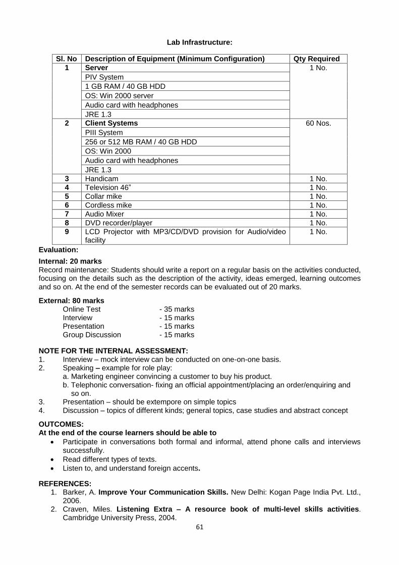
61
Lab Infrastructure:
Sl. No Description of Equipment (Minimum Configuration) Qty Required
1 Server 1 No.
PIV System
1 GB RAM / 40 GB HDD
OS: Win 2000 server
Audio card with headphones
JRE 1.3
2 Client Systems 60 Nos.
PIII System
256 or 512 MB RAM / 40 GB HDD
OS: Win 2000
Audio card with headphones
JRE 1.3
3 Handicam 1 No.
4 Television 46” 1 No.
5 Collar mike 1 No.
6 Cordless mike 1 No.
7 Audio Mixer 1 No.
8 DVD recorder/player 1 No.
9 LCD Projector with MP3/CD/DVD provision for Audio/video facility
1 No.
Evaluation:
Internal: 20 marks Record maintenance: Students should write a report on a regular basis on the activities conducted, focusing on the details such as the description of the activity, ideas emerged, learning outcomes and so on. At the end of the semester records can be evaluated out of 20 marks.
External: 80 marks Online Test - 35 marks
Interview - 15 marks Presentation - 15 marks Group Discussion - 15 marks
NOTE FOR THE INTERNAL ASSESSMENT: 1. Interview – mock interview can be conducted on one-on-one basis. 2. Speaking – example for role play: a. Marketing engineer convincing a customer to buy his product. b. Telephonic conversation- fixing an official appointment/placing an order/enquiring and so on. 3. Presentation – should be extempore on simple topics 4. Discussion – topics of different kinds; general topics, case studies and abstract concept
OUTCOMES: At the end of the course learners should be able to
Participate in conversations both formal and informal, attend phone calls and interviews successfully.
Read different types of texts.
Listen to, and understand foreign accents.
REFERENCES: 1. Barker, A. Improve Your Communication Skills. New Delhi: Kogan Page India Pvt. Ltd.,
2006. 2. Craven, Miles. Listening Extra – A resource book of multi-level skills activities.
Cambridge University Press, 2004.
62
3. Gammidge, Mick. Speaking Extra - A resource book of multi-level skills activities. Cambridge University Press, 2004.
4. Hartley, Peter. Group Communication. London: Routledge, 2004.
5. John Seely. The Oxford Guide to Writing and Speaking. New Delhi: Oxford University Press, 2004.
6. Naterop Jean & Rod Revell. Telephoning in English. Cambridge University Press,1987. 7. Ramesh, Gopalswamy and Mahadevan Ramesh. The ACE of Soft Skills. New Delhi:
Pearson, 2010.
Web Sources: 1. www.humanresources.about.com 2. www.careerride.com
GI6701 DECISION SUPPORT SYSTEM FOR RESOURCE MANAGEMENT L T P C 3 0 0 3
OBJECTIVES:
To impart the knowledge of Expert Systems, fuzzy logic and operation research techniques for Geoinformatics Engineering.
UNIT I STRUCTURE 9
Definition – Features, needs, components – characteristics – players - Structure and phases of
building ES – Types – Rule based, Frame based & Hybrid – Design, Planning, monitoring.
UNIT II KNOWLEDGE ACQUISITION 9 Knowledge Acquisition stages – Representation schemes, Rule, Semantic network, frames and
logic – Inference Techniques – Types of Reasoning deductive, inductive, adductive, analogical
and non-monotonic – conflict resolution - types of inference: forward and backward chaining - search techniques
UNIT III RULE BASED EXPERT SYSTEMS 9 Evolution – Architecture – Examples – backward and forward chaining - rules and meta rules – rule based systems – Case studies: MYCIN, PROSPECTOR
UNIT IV INEXACT REASONING 9 Bayesian theory, examples – Certainty theory: overview, uncertain evidence, rule inferencing - certainty factors – Fuzzy sets – Representation, hedges inference & fuzzy logic – Rule base for interpretation of RS data.
UNIT V OPERATION RESEARCH 9 Origin - Nature and significance - Models and Modeling – Applications and Scope - Problem formulation – structure and assumptions - standard form – Graphical solution – solution by simplex method – Sensitivity Analysis Duality – Formulations of Dual problem – Geoinformatics problems & solutions- use of AHP.
TOTAL: 45 PERIODS OUTCOMES: At the end of the course the student will be able to understand
The structure of knowledge based system and its implementation
The concepts of rule based expert system and fuzzy based systems
The scope and applications of operation research techniques in geoinformatics
TEXTBOOKS: 1. Peter Jackson, “Introduction to Expert systems”, Pearson Education, 2004. 2. Turban E., “Expert Systems and Applied Artificial Intelligence”, Macmillan, 2004.
REFERENCES: 1. Donald A.Waterman., “A Guide to Expert systems”, Pearson Education, 2001.
63
2. Durkin.J., “Expert Systems Design and Development”, Prentice Hall, 1994 3. Dan.W.Patterson, “Introduction to Artificial Intelligence and Expert systems”,Prentice Hall,
2003. 4. Ermine.J.I, “Expert Systems: Theory and Practice”, Prentice Hall, 2003.
GI6702 DISASTER MITIGATION AND MANAGEMENT FOR GEOINFORMATICS ENGINEERING L T P C 3 0 0 3
OBJECTIVES:
To understand various technological options especially Remote Sensing and GIS in Disaster management.
UNIT I DISASTER PRINCIPLES 9 Basic concepts and principles - Hydrological and geological disasters, characteristics crisis and consequences - Role of Government administration, University research organization and NGO‟s - International disaster assistance - Sharing technology and technical expertise.
UNIT II LONG TERM MITIGATION MEASURES 9 Needs and approach towards prevention - Principles and components of mitigation Disaster legislation and policy - Insurance - Cost effective analysis - Utilisation of resources -Training - Education - Public awareness - Roles of media.
UNIT III SAFETY RATING OF STRUCTURES 9 Slope stability of Ghat roads -Structural safety of Dams, Bridges, Hospitals, Industrial structures, - Disaster resistant structures - Low cost housing for disaster prone areas - Cyclone shelter projects and their implications - Reconstruction after disasters: Issues of practices.
UNIT IV SPACE SCIENCE INPUT IN DISASTER MANAGEMENT 9 Remote sensing in Hazard evaluation - Zonation - Risk assessment - Damage assessment- Land use planning and regulation for sustainable development –Communication satellite application- Network- Use of Internet - Warning system - Post disaster review - Case studies.
UNIT V EMERGENCY PLANNING USING SPATIAL AND NON-SPATIAL DATA 9 Information systems management - Spatial and non-spatial data bank creation - Operational emergency management - Vulnerability analysis of infrastructure and settlements - Predisaster and post disaster planning for relief operations - Potential of GIS application in development planning - Disaster management plan - Case studies.
TOTAL: 45 PERIODS
OUTCOMES:
At the end of the course the student will be able to understand
The concepts of disaster and disaster management
Different techniques for analysis of disaster proneness and mitigation measures
The use of spatial science in four folds of disaster management
TEXTBOOKS: 1. Bell, F.G. Geological Hazards: Their assessment, avoidance and mitigation. E & FN
SPON Routledge, London. 1999. 2. David Alexander, Natural Disasters, UCL Press, London, Research Press, New Delhi,
1993.
REFERENCES : 1. Nick Carter. W. Disaster Management - A Disaster Manager‟s Handbook. Asian
Development Bank, Philippines. 1991. 2. Mitigating Natural Disasters, Phenomena, Effects and options, A Manual for policy
makers and planners, United Nations. New York,1991.

64
3. George G. Penelis and Andreas J. Kappos - Earthquake Resistant concrete Structures. E & FN SPAN, London, 1997.
GI6703 GEOINFORMATICS PROJECT DESIGN AND MANAGEMENT L T P C 3 0 0 3
OBJECTIVES:
To provide insights into the design aspects of geomatic Engineering projects. The candidate shall be exposed to geomatic project formulation, selection of design tools, input of assessment methods and critical information and management. The candidate also familiarize with styles of reporting.
UNIT I PROJECT FORMULATION 9 Geoinformatics Project Identification - Formulation - Reconnaissance Projects - Problem Solving Projects - Testing and Evaluation Projects - Integrated Management Projects - Project Components : Data. Resources, Hardware Software, Presentation and Communication
UNIT II GRAPHICAL DESIGN TOOLS 9 Flowcharts - Data Flow Diagrams (DFD) - ER Diagrams - Hierarchical Input, Output Charts - CPM and PERT Charts - Gnatt Charts - UML Coding and CASE Tools
UNIT III ASSESSMENT METHODS 9
Rapid Assessment Reports - Leopold and Ross Matrix - Overlay Analysis - Cost Benefit Analysis and
Alternatives - Evaluation and Monitoring Formats - Accuracy and Safety Assessments
UNIT IV GEOMATIC INFORMATION MANAGEMENT 9 General Principles of Information Management (INFOSYS) - Information System Types – MIS, TPS. DSS - Geomatic Information Structure - Transaction Management - DSS in Geoinformatics
UNIT V DESIGNING REPORTS 9 Formats and Content of Geomatic Reports - Standards in Reporting - Picture File Formats and Standards - Compression Standards and Files - Web Reporting Standards - WFS and WCS - Functions and Standards - Scripts in Web Reporting (PHP, Jscript. Python , AJAX, Ruby RAIL etc..)
TOTAL: 45 PERIODS OUTCOMES: At the end of the course the student will be able to understand
Methods used for geomatics project formulation and implementation
Principles associated with assessment of geomatics projects and information management
Different ways to design and present geomatics project reports
TEXTBOOKS : 1. Clement Ogaja, Geoinformatics Engineering: A practical guide to project design,
CRC Press, 2010. 2. Barry F. Kavanagh, Geoinformatics, Prentice Hall, 2002
REFERENCES: 1. Michael Plesha Garry Gray, " Engineering Mechanics": Statistics Francesco Costanzo
2009. 2. Charles D Ghilani; Paul P.Woef, Elementary Surveying: An Introduction to
Geoinformatics 13th Edition , Prentice Hall, 2012
65
GI6711 MINI PROJECT (Activity based) (Subject related) L T P C 0 0 3 2
OBJECTIVES:
To acquire knowledge about the various tasks involved in a real time project and to train the students to complete the project in comprehensive manner in the area of Geoinformatics Engineering.
To familiarize the graduate with project design principles so as to inculcate confidence
and to provide skills in undertaking Geomatic projects.
The students shall be divided into groups with not more than 4 persons in each group. All the groups will be monitored by the assigned guide. The students in consultation with the assigned guide will identify a project related to Geoinformatics Engineering and will divide the project into 12 to 15 tasks. In each class of 4 hours duration, students shall have to complete one task in the laboratory itself under the supervision of the guide/instructor. The students will prepare and submit a consolidated report on completion of all the tasks.
For continuous assessment, 75% weightage may be given (i.e., for report submission and model oral test) and 25% weightage may be given for the end semester evaluation. The end semester evaluation by presentation only and done by a panel of three faculty members nominated by the Head of the Institution including the course co-ordinator and guide. OUTCOMES: At the end of the course the student will be able to understand
The process of designing and implementation of geomatics project
The principles of project design, reporting and progress monitoring TOTAL: 45 PERIODS
GI6712 INDUSTRIAL TRAINING L T P C (During VI Semester Summer) (4 Weeks) - - - 2
OBJECTIVES:
To train the Geoinformatics Students for the Industry so as tt-.e Students shall gain confidence in handling Practical Problems in Geoinformatics Engineering Task.
The Student can gain skills in the related training institute both by observation and involving Practical work experience.
a) The Student individually contact the organizations involved in Geoinformatics Activities with the help of the Coordinator and fix the training period and Type of Training.
b) The Students shall be evaluated on the basis of 1) Diary 2) Training Report 3) Viva-Voce Examination.
The evaluation committee consists of (1) Coordinator (2) Staff Member (3) Expert Member appointed by the Head of the Institution.
c) The Student maintain the day wise work diary while undergoing the training and get it endorsed by the supervising officer : it shall be submitted as part of evaluation
THE TRAINING REPORT: a) The Student prepares the document for the individual training following the principles of documentation standards with necessary flowcharts, diagrams, photographs and other details as the case may be. The document will be part of evaluation b) The Student shall enclose a certificate duly signed from the Supervising Officer of the Place of Training and Coordinating Faculty c) The Viva-Voce Examination shall be part of evaluation
66
OUTCOMES: At the end of the course the student will be able to understand
The intricacies of implementation textbook knowledge into practice
The concepts of developments and implementation of new techniques in geomatics
GI6801 DIGITAL CADASTRE L T P C 3 0 0 3
OBJECTIVES:
To introduce the students to the cadastral survey Methods and its applications in generation of Land information system. Cadastral surveys are those classes of land surveys which are executed for the purpose of systematically recording the land rights, producing register of land holdings or an inventory of land areas, land use and determine land tax.
UNIT I INTRODUCTION 9 History of cadastral survey - Types of survey - Tax - Real Property – Legal cadastre -Graphical and Numerical Cadastre, Legal Characteristics of Records, Torrens System.
UNIT II METHODS OF SURVEYING 9 Cadastral Survey Methods - Steps in survey of a village - Instruments used for cadastral survey & mapping - Orthogonal, Polar survey methods - Boundary survey - Rectangulation - Calculation of area of Land- GPS and Total Station in Cadastral survey.
UNIT III MAINTENANCE AND MEASUREMENTS 9 Cadastral survey maintenance - Resurveys - Measurement of sub-division - Measurement of obstructed lines - Survey of urban areas - Control requirement for Urban survey use of Satellite Imagery in boundary fixing.
UNIT IV PHOTOGRAMMETRIC METHODS 9 Photogrammetry for cadastral surveying and mapping - Orthophoto map – Quality control measures - Organisation of cadastral offices – international scenario.
UNIT V MAPPING PROCEDURES AND LIS 9 Cadastral map reproduction - Map projection for cadastral maps – Conventional symbols -map - reproduction processes - Automated cadastral map, Management of Digital Cadastral. Creation of Land Information System. Integrating LIS –Land administration.
TOTAL: 45 PERIODS
OUTCOMES: At the end of the course the student will be able to understand
The principles of Cadastral system, records and taxation
Various methods used for surveying, mapping and maintenance of cadastral records
Developments in the field of digital cadastre, LIS
TEXTBOOKS: 1. James, M. Anderson and Edward N. Mikhail, Introduction to Surveying, McGraw Hill
Book Co, 1985 2. Survey of India, Hand book of Topography, 1971
REFERENCES: 1. Alias Abdul Rahman, Siyka Zlatanova,Volker Coors, Innovations in 3D geo information
systems, 2006 2. Kahmen & Faig, Surveying, Walter de Gruyter, Berlin, 1993. 3. Peter F. Dall, John D. MeLauglin, Land information management, Oxford Press.1988
67
GI6802 2D AND 3D SURFACE MODELLING L T P C 3 0 0 3
OBJECTIVES:
To provide exposure to Surface Data in 2D and 3D and the analytical capabilities.
UNIT I TOPOGRAPHIC SURFACE DATA FORMAT AND SOURCES 9 Sources of Topographic Data - X.Y.Z data - Ground Survey Methods, Airborne Laser Scanner Data. GPS Data, Photogrammetry, Stereo Satellite Images, Space based Altimeters: Radar and LiDAR, Interferrometric Sources, SRTM, Topographic Maps - Comparison of various sources of Topographic Data - Methods of Representing Topographic Data - Digital Elevation Models, TIN Model, Contours.
UNIT II 2D - LAND SURFACE MODELLING 9 Geomorphometry - Conceptual and Digital Models of Land Surface - Various Methods of OEM Production - Land Surface Parameters: Local and Regional Parameters, Error analysis: Reducing errors in OEM, Reduction of errors in parameters and objects. Uncertainity in OEM, Geostatistical Analysis of errors in DEM. error Propagation
UNIT III APPLICATIONS OF 2D LAND SURFACES 9 Applications of OEM, TIN and other surface Data - Hydrological Applications: Flow Algorithm and Flow Direction. Topo-Climatological Applications. Landform elements Applications. Meterological Applications. Landslide susceptibility applications - Landscape Mapping and Modelling Application - case studies
UNIT IV 3D SURFACE ANALYSIS 9 3D Array - Octree and 3D TIN - constructive solid geometry (CSG) - 3d TIN tessellations - 3D distance transformation and voronoi tessellation - 3D visualization and editing - 3D web GIS - 3D application in Flood modeling, urban engineering and climatic system analysis - shading and illumination - 3D and animation.
UNIT V VISUALISATION OF 2D AND 3D SURFACES 9 Visualisation of 2D and 3D surfaces - Software used for Visualisation: Proprietary GIS s/w, SAGA. Landserf, MicroDEM. VRML and Java for interactive 3D visualization - 3D City Models WEB 3D GIS
TOTAL: 45 PERIODS OUTCOMES: At the end of the course the student will be able to understand
The intricacies of implementation textbook knowledge into practice
The concepts of developments and implementation of new techniques in geomatics
TEXTBOOKS : 1. Tomislav Hengl, Hannes L Reuter, Geomorphometry-Concepts, Software and Applications.
Developments in Soil Science, Volume 33, Elsevier, 2009 2. Rudiger Mach. Peter Petschek, Visualization of Digital Terrain and Landscape Data: A
Manual. springer, 2007. GI6811 PROJECT WORK L T P C
0 0 12 6 OBJECTIVES:
The focus on project work is to enable the students to work individually or as a group of not more than four members on a project involving comprehension of their skills either on experimental or application studies related to Geoinformatics implementation.
The group project may be on (i) one problem and segments of results or (ii) one problem solution (methodology) and different applications. If more than one student is involved, the project shall be divided into part I, Part II etc, and each student has to concentrate in one of the parts.
68
Every project work shall have a guide who is a member of the faculty of the University. Twelve periods per week shall be allotted in the Time Table and the time shall be utilized by the students to receive directions from the guide, library reading, laboratory work,
computer analysis or field work and to present the progress made in the project. The
student shall maintain a weekly progress chart and attach the same in the report along with the signature of the guide.
Each student shall finally produce a comprehensive report covering background information, literature survey, problem statement, methodology, project work details, results and conclusions. This final report shall be typewritten form as specified in the guidelines. The report shall follow the guidelines for format, structure, text size, number of pages and other style manual standards prescribed by the University. Evaluation shall be done as prescribed in the Regulation.
TOTAL : 180 PERIODS
OUTCOMES: At the end of the course the student will be able to
Implement the knowledge and exposure gained in the previous semester for solving real time problems
Develop systems that improve capabilities of existing instruments, techniques and methods.
GI6001 ADVANCED SURVEY ADJUSTMENT L T P C 3 0 0 3
OBJECTIVES:
To impart advanced skills in survey adjustment to suit field conditions
UNIT I PRE ANALYSIS OF SURVEY MEASUREMENTS 9 Pre analysis procedure- Horizontal angle measurement with theodolite- Distance measurement by EDM - elevation difference by Direct leveling - Survey tolerances.
UNIT II STATISTICAL ANALYSIS OF SURVEY MEASUREMENTS 9 Samples and statistics - The Chi-square distribution - the t-student distribution - common sample statistics - estimation of mean and variance - Confident interval for the mean and variance - statistical testing-Test or the mean of probability distribution - Test of the variance of a probability distribution. Bivariate normal distribution.
UNIT III GENERAL LEAST SQUARES ADJUSTMENT 9 Introduction - Derivation - Precision estimation of special cases - Application of least squares adjustment in GIS and GPS.
UNIT IV APPLICATION IN PLANE COORDINATE SURVEYS 9 Introduction- the distance condition and its linearization- azimuth condition and its linearization - angle condition and its linearization - position fixing by Distance - Two parameter similarity transformation - Four parameter similarity Transformation.
UNIT V SPECIAL SUBJECTS OF STATISTICS 9 Theory of prediction and filtering - sequential adjustment (static and Kinematic Kalman-filter) Application of Kalman-filter in Geodesy; Goodness of fit - Test of any distribution.
TOTAL: 45 PERIODS OUTCOMES: At the end of the course the student will be able to understand
Advancements in adjustments survey measurements using statistics analysis and least square adjustment procedure
69
Concepts for adjustment and prediction of geodetic variables
TEXTBOOKS : 1. Mikhail, E.M. and Gracie G., Analysis and adjustment of Survey measurements, Van
Nostrand Reinhold, New York, 2005 2. Bannister A. and Raymond B., “Surveying”, ELBS edition, 2006. 3. Bannister A. and Raymond B., “Solving problems in surveying”, ELBS edition, 2006.
REFERENCE: 1. Paul.R.Wolf and Charles. D.Ghilani, Adjustment Computations - Statistics and least
squares in surveying and GIS, John Wiley and sons inc., 1996.
GI6002 AIRBORNE LASER TERRAIN MAPPING L T P C 3 0 0 3
OBJECTIVES:
To introduce the concepts of Space Borne, Air Borne, Terrestrial and Bathymetric LASER Scanners for Topographic and Bathymetric Mapping
UNIT I SPACE BORNE RADAR AND LIDAR ALTIMETER 9 Principle and Properties of LASER- Range Finder, DIAL and Doppler LiDAR - Platforms: Terrestrial, Airborne and Space borne LiDAR – Space Borne LiDAR Missions – Space Borne Radar Altimeter for mapping Sea Surface Topography – Space Borne Laser Altimeter and Applications UNIT II AIRBORNE LASER SCANNERS 9 Airborne Topographic Laser Scanner – Ranging Principle – Pulse Laser and Continuous Wave Laser – First Return and Last Return – Ellipsoidal and Geoidal Height - Typical parameters of a Airborne Laser Scanner (ALS) – Specifications of Commercial ALS – Various Application Domains of ALS - Merits of ALS in comparison to Levelling, GPS leveling, Photogrammetry and Interferrometry - Components of ALS - GPS, IMU, LASER Scanner, Imaging Device, Hardware and Software
UNIT III DATA ACQUISITION AND PRE PROCESSING 9 Various Scanning Mechanism – Synchronization of GPS, IMU and ALS Data - Reflectivity of terrain objects – Laser Classification – Class I to Class IV Laser – Eye Safety - Flight Planning– Determination of various data acquisition parameters – Swath Width, Point Density, No. of Strips, Area Covered, Point Spacing - Data Processing – Determination of flight trajectory - LIDAR data formats.
UNIT IV POST PROCESSING AND APPLICATIONS 9 Post Processing – Geo location of Laser Foot Prints – Various Co-ordinate Transformations involved - Strip Adjustment - Filtering - Ground Point filtering – Digital Elevation Model - Error Sources - Overview of LIDAR Applications in various domains - 3D city models – Corridor Mapping Applications – Forestry Applications - Feature extraction, Ortho images. UNIT V TERRESTRIAL AND BATHYMETRIC LASER SCANNERS 9 Terrestrial Laser Scanners(TLS) – Working Principle – Commercial TLS Specifications –Bathymetric Laser Scanners (BLS) – Working Principle of BLS – Depth of Penetration of BLS – Applications of TLS and BLS
TOTAL : 45 PERIODS OUTCOMES: At the end of the course the student will be able to understand
Concepts of ALTM and working principle
Available types of ATLM sensors and components of ALTM system
70
Process of data acquisition, data processing and possible applications
The fundamentals of terrestrial and bathymetric scanners and their applications
TEXTBOOKS: 1. Jie Shan and Charles K. Toth, Topographic Laser Ranging and Scanning – Principles
and Processing, CRC Press, Taylor & Francis Group, 2009 2. George Vosselman, Airborne and Terrestrial Laser Scanning, Taylor & Francis, 2010.
REFERENCES: 1. Zhilin Li, Qing Zhu, Chris Gold, Digital terrain modeling: principles and methodology,
CRC Press, 2005 2. ISPRS Journal of Photogrammetry and Remote Sensing, Special Issue on Airborne
Laser Scanning and Mapping, Volume 54, Issue 2-3, July 1999 3. Roger Read and Ron Graham, Manual of Aerial Survey: Primary Data Acquisition,
Whittles Publishing, 2002.
GI6003 CLOSE RANGE PHOTOGRAMMETRY L T P C 3 0 0 3
OBJECTIVES:
To focuss how the terrestrial objects can be mapped by taking photographs.
To study not only in engineering aspects but also in the Medicine, Forensic applications.
UNIT I NON-TOPOGRAPHIC PHOTOGRAMMETRY 9 Introduction - Origin - basic Geometric concepts - Data acquisition - Camera systems - Metric -Non metric cameras - Analytic data reduction - Collinearity adjustment - Direct linear transformation - coordinate transformation - acquisition of digital imagery and processing -software modules for processing the data
UNIT II STRUCTURAL STUDIES 9 Structural research: Deformation studies of deflection, buckling, - Advantages and disadvantages, Dam deformation, structural movement, Pavement yield. Hydraulic studies: Pipe surface roughness, shifting sand-bank, shoreline feature and coastal currents, experimental fluid mechanics.
UNIT III MEDICINE 9 Monocular and binocular health studies, X-ray Photogrammetry, surface area and volume patients by Photogrammetry - merits over usual methods. Postural analysis - historical use of Photogrammetric methods - Study of body alignment and rate of body mechanics, remedial measures, advantages - Bio stereo metrics.
UNIT IV INDUSTRIAL PHOTOGRAMMETRY 9 Data acquisition systems - data reduction - deformation of engineering structures - pipe systems - measuring communication antennas - tunnel surveys - cooling towers and other applications -Applications in automobile industry - Architecture application: Drawing of details, monuments preservation and archaeological applications.
UNIT V CRIMINOLOGY 9 Single and stereo photographs for forensic studies, investigation of criminal cases by black & white, ultra-violet, infrared and colour Photogrammetry, examples. Use of stereometric camera for crime detection, accident investigations. Mono or stereo camera for investigation. Anthropometry - Under water Photogrammetry - Electron microscopy, Hologrammetry - Moire topography - systems and applications - emerging trend.
(L:45) TOTAL : 45 PERIODS
71
OUTCOMES: At the end of the course the student will be able to understand
The principles of terrestrial and close range photogrammetry
The possible application of terrestrial and close range photogrammetry in medicine, structural analysis, criminology and industries
TEXTBOOKS: 1. Atkinson, Development in Close Range Photogrammetry - I, Development series, 1988 2. Bandekar, J. “Photogrammetric surveys of monuments and sites, North HollandPublishing
Co., American Elsevier Publishing Co., 1975
REFERENCE: 1. Karara, H.M., Non topographic Photogrammetry, 2nd Edition American Society for Photo
grammetry and Remote Sensing, 1989 GI6004 DIGITAL CARTOGRAPHY L T P C 3 0 0 3
OBJECTIVES:
To gain knowledge and practice the art, science and technology of digital cartography for designing, visualization and communication of Maps and other Cartographic products using computing and information technology.
To gain skills in the use of cartographic and GIS software, algorithms and hardware.
UNIT I INTRODUCTION 9 Cartographic Products and Map automation – logics in digital map design – infra-structures, tools and functions in automated mapping – map layout, multiple maps, color and patterns in digital mapping – human perception of static, multi-media and animated maps.
UNIT II DATA CAPTURE AND REPRESENTATION 9 Spatial data capture in raster and vector formats – texture data capture / creation – non-spatial data loggers and attributes – metadata design - data classes and graphics for metadata – graphics and maps – storage, warehousing and mining for automated mapping – graphic formats for visualization, communication and printing – compressions and standards.
UNIT III DIGITAL MAP DESIGN 9 Selection of point, line and pattern symbols – simple and multivariate maps – information abstraction and maps –scientific and artistic design principles – designing dynamics – time representation and animation – animated and multimedia maps – representing processes – 3D graphical designs and maps.
UNIT IV GEOVISUALIZATION 9
Flat maps and raised maps – terrain visualization – visualization of uncertainty – flow maps –
virtual maps – simulated maps – mobile information and mobile maps – web mapping – widgets/dashboard UNIT V DIGITAL MAP MODELING 9 Map generalization – geo-statistics in generalization, and quantitative mapping – digital classification – contiguity and hierarchy in mapping – map models
TOTAL : 45 PERIODS OUTCOMES: At the end of the course the student will be able to understand
The concept of digital mapping and automated mapping
The principles involved in data collection and cartographic design of digital maps
The concepts of geovisulisation and map modelling
72
TEXTBOOKS: 1. Robert G Cromley, Principles of Digital Cartography, Prentice hall, 1992 2. Word, Clifford H and C peter kerer Cartigraphic Designs-theoretical and practical
perspective, John wiley & sones, chichester, 1996
REFERENCES: 1. Menno Jan Kraak & Ferjan Ormeling, Cartography Visualization of Geospatial Data, 2nd
Edition, Pearson Education, 2004 2. Jobst, Markus, ”Presentation in Digital Cartography, 2010. 3. Ruas, dnme,” Advances in Cartography and GI Science,” Vol 1,2011 4. Lindur,Wilfried,” Digital Photogrammetry “ Springer, 2009
GI6005 ERROR ANALYSIS AND DATA SECURITY L T P C 3 0 0 3
OBJECTIVES :
To provide knowledge of uncertainity in handling geospatial data. Uncertainity exists in terms of data capture, positional accuracy, surface modeling and spatial modeling.
To familiarize errors due to uncertainity and also mathematical foundations of errors including quality control
UNIT I UNCERTIANITY 9 Concept of uncertainty – concept of error – dimension of global data- Spatial data quality- Measurement of uncertainty – Spatial data capture uncertainity- uncertainty in Spatial Analysis
UNIT II MATHEMATICAL FOUNDATIONS 9 Geo Statistical Data and Lattice – Probability and Distribution function- shafer themes of evidence for spatial data – fuzzy logic – rough sets- information theory and entrophy
UNIT III POSITIONAL AND ATTRIBUTE UNCERTAINTY 9 Existing, positional error models – Distribution Model for line - curves and Polygons uncertainty – attribute uncertainties and models – Sensitivity Analysis – integrated positional and attribute modeling.
UNIT IV UNCERTANITIES N SPATIAL MODELLING AND SPATIAL ANLAYSIS 9 Topology – topological relations – surface modeling and errors- TIN and Grid DEM- overlay Analysis and polygons – Buffer Analysis – simplification of objects and errors.
UNIT V QUALITY CONTROL AND SECURITY 9
Quality control for Cadastral data - quality and object – based data – quality and field based data
– DEM and interpolation – Meta data- Quality – data security. TOTAL: 45 PERIODS
OUTCOMES: At the end of the course the student will be able to understand
The concepts of error, uncertainty and their measurement
Mathematics basics required for quantification of uncertainty in mapping and modeling
Concept of quality control procedures for spatial data quality and security
TEXTBOOKS: 1. Wenzhong Shi, Principles of Modeling Uncertainties in Spatial Data and Spatial Analysis,
CRC Press, Boca Raton, London, New York, 2010 2. Abdul-Rahman. A and M.Pilouk, Spatial Data Modelling for 3D GIS, Springer- Verlag,
Berlin, 2008
73
REFERENCES: 1. John Robert Taylor., “An Introduction to Error analysis ; the study of uncertainty in physical
measurements, 2nd edition, 1996 2. Kabatiansky. G, EKrouke, S. Semenov Error Correcting coding and security for data
networks- Analysis of super channel concept -John Wiley & sons, 2005
GI6006 ENVIRONMENTAL GEOINFORMATICS L T P C 3 0 0 3
OBJECTIVES:
The objective of this course is to expose the students to the applications of Remote Sensing and GIS for water quality assessment, soil degradation assessment and monitoring pollution.
UNIT I WATER AND THE ENVIRONMENT 9 Sources and demands of water - Characteristics of water- Point and non-point sources of ater
pollution - Spectral responses of clear and contaminated water - chlorophyll- Remote Sensing
of Water quality assessment - Classification of water quality for various purposes, Sampling procedure, quality analysis, Data base creation and quality modeling using GIS. Database Creation and designing water supply network, sewerage network using GIS. Runoff estimation- flood prediction modeling.
UNIT II SOIL CONSERVATION AND MANAGEMENT 9
Taxonomical classification of soils, sampling, soil survey interpretation and mapping, impact of
agricultural and industrial activity on soil properties. Formation of Soils- land forms- soil erosion-factors influencing soil erosion, soil contamination- distribution and accumulation of contaminants such as toxic metals, synthetic chemicals in soil- mining pollution- methods of conservation- afforestation- EMR responses with contaminated soil - modeling soil characteristics using satellite data-soil degradation assessment using Remote Sensing and GIS- Land reclamation.
UNIT III ECOLOGY AND ECOSYSTEM 9 Conservation and resource management - spectral reflectance from vegetated surface - Stress monitoring - Land cover and Land use mapping - forest conservation - Biodiversity- biomonitoring of the environment and Remote Sensing - wild life studies - Revenue management-environment and ecological concerns- Resource development in remote areas- Impacts of anthropogenic activity- Solid Waste management, Design of collection network using GIS.
UNIT IV SENSORS AND DATA FOR ENVIRONMENTAL MONITORING 9 Sensors for environmental monitoring - sensors - LIDARS- LASER Remote Sensing -visible and outside visible wave length -absorption spectrometers - selection of ground truthsites-sea truth observation - Radar techniques for sensing ocean surface - thermal measurements- application of remote sensing for oil slicks mapping - Chlorophyll detection - Fisheries resources - Coastal marine studies - determination of temperature and sea state.
UNIT V AIR POLLUTION AND GLOBAL CLIMATOLOGY 9 Air Pollutants- Dispersion modeling -Air quality monitoring - case studies -climatology - emissivity
characteristics- measurements of atmospheric temperature - composition -constituent distribution
and concentration- wind flows and air circulation – Hurricane tracking - meteorological satellite systems.
TOTAL: 45 PERIODS OUTCOMES: At the end of the course the student will be able to appreciate
The possible applications of Remote Sensing and GIS in water quality, soil conservation and ecology
The availability various remote sensing sensors for acquiring environmental datasets
The use of satellite remote sensing in climatology and air pollution studies
74
TEXTBOOKS : 1. Andrew N. Rencz, Manual of Remote Sensing: Remote Sensing for Natural Resource
Management and Environmental Monitoring, John Wiley & Sons Inc, April 2004. 2. Baretl, E.C. and Culis I.F. Introduction to Environmental Remote Sensing, 2 nd edition,
Chapman and Hall, New York, 1993.
REFERENCE: 1. Lintz, J.and Simonent, D.S."Remote sensing of environment" Addision Wesley, Rading
mars,1976. GI6007 GEOINFORMATICS FOR HYDROLOGY AND WATER RESOURCES ENGINEERING L T P C 3 0 0 3 OBJECTIVES:
To impart knowledge in various applications of hydrology and water resources using Geomatic technology.
UNIT I HYDROLOGIC COMPONENTS 9 Hydrologic cycle - estimation of various components – clouds - rainfall – runoff – evaporation – transpiration – evapo-transpiration – interception – depression storage - Spectral properties of water.
UNIT II SURFACE WATER MODELLING 9 Drainage basin – Delineation and codification of watershed - Morphometric analysis –Hydrological Modelling – Rainfall – runoff modelling – USDA-SCS-CN Method – Urban Hydrology – LiDAR Mapping for Urban area – Impact of Climate change on Hydrological modeling - Water quality mapping and monitoring – Correlation model for pollution detection.
UNIT III RISK AND DAMAGE ASSESSMENT 9
Mapping of snow covered area – Snow melt runoff – glacier runoff modelling – flood forecasting –
Flood Risk Zoning - Flood damage assessment – Flood Modelling - Early warning system for flood mitigation – drought – types – assessment of droughts and mitigation - water harvesting structures
UNIT IV GROUND WATER MODELLING 9 Origin – classification and properties of aquifer – ground water potential identification – surface indicators – aquifer parameters – hydrologic budgeting – different types of ground water models –
mathematical modelling of ground water system - seawater intrusion – interfacing GIS with
ground water model - artificial recharge of ground water
UNIT V IRRIGATION AND WATERSHED MANAGEMENT 9 Project investigation, implementation, maintenance stage – location of storage/diversion works – capacity curve generation – hydro-economic conjunctive use model – impact of climate and land use change on drainage basin – sediment yield - modelling of reservoir siltation – prioritization of watersheds – watershed modelling for sustainable development.
TOTAL : 45 PERIODS OUTCOMES: At the end of the course the student will be able to understand
The components of hydrologic system and their measurement through remote sensing systems
The techniques useful for assessment of Risk and Damage due to water related disasters using remote sensing and GIS
75
The modeling tools for ground water flow modeling
Assess the irrigation water requirement and watershed management through intervention of remote sensing and GIS tools
TEXTBOOKS: 1. Dr. David Maidment and Dr.Dean Djokic, "Hydologic and hydraulic modeling support with
GIS", ESRI press New York - 2000. 2. Gert A.Schulitz. Edwin T. Engman, " Remote Sensing in hydrology and Water
Management", Springer-verlag Barlin Heidelberg Germany - 2000.
REFERENCES : 1. Hopkinson C, Pietroniro A, Poneroy J "hydrosan Airborne Laser Mapping of
hydrological features and Resources Environment", 2008 2. Michael Good child, Bradley O parks, Louis T Steyart “Environmental modeling with GIS,
1993 3. Baxter E nieux,” Distributed hydrologic modeling using GIS, 2004
GI6008 GEOINFORMATICS FOR OCEAN ENGINEERING AND COASTAL L T P C ZONE MANAGEMENT 3 0 0 3
OBJECTIVES:
To familiarize the students about the basics and Geomatic applications in the field of
ocean Engineering and Coastal Management
UNIT I OCEAN ENGINEERING 9 Coastal processes – Oceanic circulation – Upwelling and sinking – Waves – Wave Characteristics – Wave generated currents – Catastrophic waves – Wave-current interactions – Tides – Tidal forces – Littoral drift – Numerical models of hydro dynamics and sediment transport – Bathymetry – Navigational Charts.
UNIT II OCEANOGRAPHY AND NUMERICAL MODELLING 9 Physical properties of sea water – chemistry of sea water – Biological parameters – Oceanographic instruments – collection of water samples – current measuring devices – deep sea coring devices – Numerical modelling of ocean – Navier stokes equation – Tsunami propagation and run up.
UNIT III COASTAL DYNAMICS 9 Coastal Hydrodynamics - Estuarian dynamics – Hydrodynamics of pollution dispersion – Modelling of suspended sediments – Coastal erosion – Shore line change dynamics – Coastal protection works – Design of Breakwater
UNIT IV GEOMATIC OCEANOGRAPHY 9 Satellite sensors for Ocean and coastal applications – Chlorophyll and suspended sediment estimation – Satellite altimetry – Physical – Biological interactions – Eddy kinetic energy– Retrieval of physical parameters – sea surface roughness – sea surface temperature – significant wave height – wind speed and direction – Ocean circulation – Tidal variations – sea level rise – coastal bathymetry.
UNIT V COSTAL ZONE MANAGEMENT 9 Introduction – major issues/ problems – Thematic maps on coastal resources – wetland classification – mapping of shore line changes – coastal interactions -coastal regulation zone mapping – creation of CZIS – ICZM model concepts and case studies – resolving conflict on resources utilization – coastal aquifer modelling.
TOTAL : 45 PERIODS
76
OUTCOMES: At the end of the course the student will be able to understand
The basics of Ocean processes and characteristics of Ocean parameters
The concepts of ocean dynamics and design of appropriate structures
The use of remote sensing sensors for mapping and modeling oceanic processes and Coastal Zone management
TEXTBOOKS: 1. Vasilis D. Valavanis, GIS in oceanography & Fisheries, Taylor & Francis London & New
York, 2002 2. Alasdair J.Edward, Remote Sensing Handbook for Tropical Coastal Management,
UNESCO publishing, 2000.
REFERENCES : 1. Grant Gross,M., "Oceangraphy, Merrill Publishing company", Columbus, U.S.A., 2002. 2. Karsten Manager, Shoreline Management Guidelines, DHI Water & Environment,
Denmark, 2004. 3. Dean,R.G. nd Dalrymple, R.A., Coastal Process with Engineering Application, Cambridge
University press, Cambridge, 2006. 4. Paul D.Kumar, Beach process and sedimentation. Prentice - Hall Inc., New Jersey, 2002.
GI6009 GEOINFORMATICS FOR AGRICULTURE AND FORESTRY L T P C 3 0 0 3
OBJECTIVES :
This course enables the students to understand and apply remote sensing and GIS techniques in various fields of agriculture, soil, land and forest resources.
UNIT I CROPS 9 Introduction - leaf optical properties - identification of crops and crop inventorying - crop acreage estimation - vegetation indices - yield estimation - crop production forecasting through digital analysis - microwave and hyper spectral sensing for crop inventory - crop monitoring and condition assessment in command areas - case studies.
UNIT II SOILS 9 Introduction - soil survey, types of soil surveys - soil genesis and soil classification -soil taxonomy - soil reflectance properties - soil mapping using remote sensing – problem soils -saline, alkali soil characteristics - mapping of saline alkaline soils - soil erosion and sedimentation - assessment of soil erosion - estimation of reservoir capacity.
UNIT III LAND EVALUATION AND MANAGEMENT 9
Introduction - land use / land cover definition - land use / land cover classification-concepts and
approaches of land evaluation - parametric methods - change detection in land uses - decision support system for land use planning - optimum land use planning for sustainable agriculture.
UNIT IV DAMAGE ASSESSMENT 9
Introduction - damage by pests and diseases - crop loss assessment by floods - flood hazard zone
mapping - remote sensing capabilities and contributions for drought management - land degradation due to water logging and salinity - crop stress - reflectance properties of stressed crops - identification of crop stress.
UNIT V FORESTRY 9 Introduction - forest taxonomy - inventory of forests - forest type and density mapping-biomass assessment - timber volume estimation - factors for forest degradation-mapping degraded forests - deforestation and a forestation - forest fire mapping and damage assessment - sustainable development of forests.
TOTAL : 45 PERIODS
77
OUTCOMES: At the end of the course the student will be able to understand
Characterization of crops using Remote Sensing tools
The concepts of soil mapping through remote sensing
The evaluation of land capability for better land use planning
The methods to assess damage to crop by floods, droughts, pests using remote sensing techniques
Characterization of forest entities for analysis of deforestation, forest fire damages
TEXTBOOKS: 1. Srinivas, M.G.,Remote Sensing Applications, Narosa Publishing House, New Delhi,
2001. 2. Andrew Rencz, Manual of Remote Sensing. Vol.3. Edn.3. Remote Sensing for the Earth
Sciences, American Society for Photogrammetry and Remote Sensing, John Wiley & Sons, New York, 1999
REFERENCES : 1. Jensen, J.R., Remote Sensing of the Environment - An Earth Resource
Perspective.Dorling Kindersley (India) Pvt. Ltd., New Delhi, 2001 2. Agarwal, C.S. and Garg P.K., Textbook on Remote Sensing in Natural Resources
Monitoring and Management. Wheeler Publishing, New Delhi, 2000 3. Narayan, L.R.A., Remote Sensing and its Applications. Universities Press (India) Ltd.,
Hyderabad, 2001.
GI6010 GEOINFORMATICS FOR CLIMATIC CHANGE STUDIES L T P C 3 0 0 3
OBJECTIVES :
To address the climate as dynamical systems is the main objective of the course.
To focuss both historical, archaeological and anthropogenic evidences of climatic change.
Special emphasis is given for hazard assessment and climatic change models
UNIT I BASICS OF CLIMATIC CHANGE 9 Concepts of climatic cycles and long term changes – earth orbital variations – solar flares and outputs – magnetic and force fields – earth movements and energy release – ocean variability and periodic cycles –impacts of earthquakes and volcanoes.
UNIT II THROPOGENIC IMPACTS 9 Anthropogenic impacts- agriculture and impacts - industries and pollutions – urbanization – vehicles, transport and fossil fuels - chemicals, synthetics, solid wastes and gas outputs – municipal wastes
UNIT III CHANGE ASSESSMENT 9 Historical evidences – archeological evidences – indicators of vegetation: species limits, pollens, tree rings and fossils – temperature and precipitation trends – evidences from terrain evaluation – ice and glacier changes – sea- level assessments – under water assessments – sediment analysis
UNIT IV CHANGE HAZARDS 9 Global warming and impacts – carbon gas build up – possible land use changes – land productivity and livelihood changes – forest fires and wild life – impacts on water bodies – floods and droughts – human health impacts-Change Management: Use of renewable energy – land use adaptation - planning disaster mitigation
UNIT V CLIMATE CHANGE MODELS 9 Climate change Models – RCM – GCM - Ozone depletion – greenhouse gas carbon- sequestration-IPCC and Indian scenario
TOTAL: 45 PERIODS
78
OUTCOMES: At the end of the course the student will be able to understand
The concepts of climate change and effects of anthropogenic impacts
The methods for analysis of climate change and corresponding hazards
The methods and models available for prediction of future scenarios
TEXTBOOKS: 1. William James Burroughs , Climate change : A multidisciplinary Approach 2007 2. Jane Mc Adam ,”Climate change and Displacement Multi disciplinary Perspectines”2010
REFERENCES: 1. Richard C.J. Somerville” the forgiving Air: understanding Environmental change, IInd
Edition, American Meteorological Society, 2008 2. Heidi Cullen, The weather of the future; heat waves, extreme storms, and other scenes
from a climate changed planet, 2010 3. Stephen H Schneider, “Science as a contact sport inside the battle to save earth‟s
climate, 2009 4. James Hoggan Climate cover up; the crusade to Deny global warming, 2009
GI6011 GEOINFORMATICS FOR LAND RESOURCES MANAGEMENT L T P C 3 0 0 3
OBJECTIVES:
To familiarize the students in Land Resource Analysis and planning for sustainable development. Policy issues and legal aspects or consider equally important for Land Resource Development.
UNIT I LAND RESOURCE SYSTEMS 9 Geodetic Networks and GPS Surveys – Topographic and Bathy Metric Surveys – Cadastral Information – Soil and Land Use Surveys - Land Capability Maps – Hierarchy of Land Records – Land Information System (LIS / LRS) Design – Record Update Limitations – Land Holdings and Revenue Records – Real Estate Information System
UNIT II LAND RESOURCE POTENTIALS 9 Geomorphologic Capabilities – Hydro-Geological Mapping – Land Erosivity and Erodability Analysis – Soil Capability and Loss Assessment – Locational and Climatic Advantages – Settlements and Demographic Pressure Estimation – Urban and Commercial Market Potentials on Land
UNIT III POLICIES AND ISSUES 9 Land Holdings – Reserved and Restricted Lands – Hazard and Disaster Prone Areas – Land Acquisition - Land Use Policies – Land and Noxious Facilities – Legality and Community Participation – Conflicts of Interests
UNIT IV LAND USE MANAGEMENT 9 Classification of Land Uses – Rural Land Use Analysis – Urban Land Use Analysis – Municipal Lands and Open Spaces in Cities and Towns - Urban Land Use Planning Strategies and DCR - Agriculture and Forest Land Management – Recreational Lands – Waste Land Management – Wetland Management
UNIT V SUSTAINABLE DEVELOPMENT 9 Concept of Sustainability – Models of Sustainability and Participatory Development Models– Economic Uses and Trade-Off Principles – Land and Waste Management – Issues of Land Protection
TOTAL: 45 PERIODS
79
OUTCOMES: At the end of the course the student will be able to understand
The concepts involved assessment of land resources
The policies and issues involved in management of land resources
The concept of sustainability and its implementation in land resources management
TEXTBOOKS: 1. Sharma H.S. and Binda P.R. “Modeling In Resource Management and Environment”
Through Geoinformatics, 2007 2. Paul Brown M. Genesis, Termination and succession in the life cycle of organizations:
the Institute of Public Administration of Canada, 1997.
REFERENCES: 1. Mario A., “Basics of Geoinformatics” Gomarasca edition 2009 2. The A to Z of careers in South Africa, 2008
GI6012 ADVANCED GEODESY L T P C 3 0 0 3
OBJECTIVES:
To impart advanced knowledge in the field of Geodesy
UNIT I GEODETIC CONTROL 9 Horizontal control – characteristics – method and standards for triangulation, traversing, trilateration, inertial and space techniques (Doppler GPS, SLR and VLBI) – computation – problems on spherical coordinates. Vertical control - characteristics – method and standards for spirit levelling , trigonometrical levelling and space techniques- computations- national networks. UNIT II GEODETIC COMPUTATIONS 9 Rectangular and Polar Co - ordinates - First and Second geodetic problem – Similarity and Helmert‟s transformation- methods of point determinations – problems on intersection, resection, arc section and also with over determinations, polar method and its extension.
UNIT III ASTRONOMICAL COMPUTATIONS 9 Variation in celestial co - ordinates, Determination of Astronomical Azimuth- stars altitude and hour angle methods, astronomical latitude and longitude determination – sources of errors and its eliminations- problems
UNIT IV HEIGHT SYSTEMS 9 Geo potential number - Orthometric height, Normal height, Dynamic height and their corrections – computation of orthometric height, Ellipsoidal height and its determination with a single and reciprocal observation of vertical angle - geoidal height – methods and computation.
UNIT V MISCELLANEOUS TOPICS 9 Crystal movements and plate motion – methods of determination of horizontal and vertical movements – dam deformation- earth tides – tidal forces, tidal response of the solid earth, tidal loading, analyzing and predicting earth tides, earth tide instrumentation – satellite altimetry – observations, computation and interpretation – Applications.
TOTAL: 45 PERIODS OUTCOMES: At the end of the course the student will be able to understand
Techniques and tools involved in establishment of geodetic control
Methods required for computation of geodetic and astronomical parameters
Concepts of monitoring crustal movement, tide measurement and applications
80
TEXTBOOKS: 1. Wolfgang Torge, “Geodesy”, Walter De Gruyter Inc., Berlin, 2001. 2. Guy Bomford ”Geodesy” Nabu Press,2010
REFERENCES: 1. Petr Vanicek and Edward J. Krakiwsky, Geodesy: The concepts, North-Holland Publications Co., Amsterdam, 1991. 2. Tom Herring, “Geodesy „ Elsevier,2009 3. Schwarze, V.S. Geodesy: The challenge of the 3rd millennium, Springer verlag, 2002. 4. James R.Smith, Introduction to Geodesy, John wiley & Sons Inc. 1997.
GI6013 SATELLITE METEOROLOGY L T P C 3 0 0 3
OBJECTIVES:
To introduce the basic concepts of Remote Sensing of atmosphere and satellite meteorology.
To gain the knowledge on meteorological applications in weather forecasting aviation and trade applications.
To familiarize the Indian Meteorological satellites and sensors.
UNIT I BASICS 9 Basics - Concepts in Satellite Meteorology - Conventional Direct Measurements - Indirect Methods and Remote Sensing
UNIT II WEATHER SATELLITES AND SENSING SYSTEMS 9 Weather Satellites and Sensing Systems - Orbit Types and Altitudes - View Angle and Implications - INSAT and KALPANA - TRMM and GPM - American and European Missions
UNIT III DATA RECORDS AND APPLICATIONS 9 Data Records and Applications - Active and Passive Sensor Data - Microwave Sensors and Applications - Altitude. Wind.. Temperature and Wave Measurements and Sensors - AWS Global Network in Measurements
UNIT IV METEOROLOGICAL APPLICATIONS 9 Meteorological Applications - Oceanographic Applications - Weather Forecasting - Aviation Meteorology - Agriculture and Irrigation Management - Meteorology in Transportation Industry - Business and Trade Application
UNIT V MANAGEMENT AND MONITORING 9 Satellite Meteorology in Welfare Management - Cyclone Warning Systems - World Precipitation and Warming - Sealevel Monitoring - Ice and Snow - Flood and Storm Surge Warning Systems - Storms - Wild Fires and Volcanic Ash
TOTAL: 45 PERIODS OUTCOMES: At the end of the course the student will be able to understand
Concepts of satellite meteorology and satellite sensors useful for the same
The applications of meteorological studies in resource management, disaster management
TEXTBOOKS: 1. Kidder and VonderHarr, “Satellite Meteorology: An introduction”, Academic Press, San
Diego, CA, 1995 2. Cracknell, “The Advanced Very High Resolution Radiometer (AVHRR)”, Taylor and
Francis Int. Ltd., Great Britain, 1997
81
REFERENCES: 1. Asnani, G.C “Tropical Meteorology”, Vol.I and II, 1993 2. Doviak and Zrnic, “Doppler Radar and Weather observations”, Academic press,
London,1992. 3. Sauvageot H., “Radar Meteorology”, Artech House Publishers, Norwood, MA, 1992 4. Kalsi S.R. “Use of Satellite Image in Tropical Cyclone Intensity Analysis and Forecasting”,
India Meteorological Department, Meteorological Monograph, Cyclone warning, New Delhi, 2002
GI6014 TRANSPORTATION GEOINFORMATICS L T P C 3 0 0 3 OBJECTIVES:
To develop an understanding of the issues and challenges in the field of
transportationengineering.
To understand the utility of Remote sensing and GIS for solving transportation engineering problems.
UNIT I ENGINEERING SURVEYS AND GEOMETRIC DESIGN 9
Road ways and railways – development - necessity for planning – classification of roads and
railways – Alignment surveys and investigations using conventional and remote sensing techniques (preliminary, reconnaissance and final location surveys) – Design principles of highway geometric elements
UNIT II URBAN TRANSPORTATION SYSTEMS AND PLANNING 9 Urban transportation: policy alternatives - Transportation and the environment -Urban transport
planning processes - Socio-demographic data and travel surveys - Transportation modeling-
Traffic congestion - Plan evaluation and implementation - Planning and financing - Critiques of transportation modeling and forecasting
UNIT III REMOTE SENSING IN TRANSPORTATION 9 Study of geographic pattern of urban development using remote sensing data products – urban sprawl – parking studies using aerial photos – traffic analysis - accident analysis - site suitability analysis for transport infrastructure – population distribution studies – improvisation of rural road network – regional road network connectivity- vehicle tracking – incident identification and management.
UNIT IV GIS AND TRANSPORTATION ANALYSIS 9
Transportation analysis in GIS: Introduction - network flows - shortest path algorithms -
transportation databases: creation and maintenance - facility location - vehicle routing – highway and railway alignment – highway maintenance
UNIT V MODELLING AND INTELLIGENT TRANSPORTATION SYSTEMS (ITS) 9 Modelling land use transport interaction - ITS development – architecture – integration with GIS – applications – case studies.
TOTAL : 45 PERIODS OUTCOMES: At the end of the course the student will be able to understand
Applications of remote sensing in alignment planning and geometric analysis
The applications of remote sensing in transportation systems analysis and planning
Tools for modeling of landuse transport interaction, ITS architecture
82
TEXTBOOKS: 1. Harvey J. Miller, Shih-Lung Shah, Geographic Information Systems for Transportation –
Principles and Applications, Oxford University Press, 2001. 2. John Stillwell, Graham Clarke, Applied GIS and Spatial Analysis, John Wiley & SonsLtd,
2004.
REFERENCES: 1. C.S. Papacostas, P.D. Prevedouros, Transportation Engineering and Planning, Prentice-
Hall India, 2002. 2. Barry Boots, Atsuyuki Okabe and Richard Thomas, Modelling Geographical Systems –
Statistical and computational applications, Kluwer Academic Publishers, 2002.
GI6015 HEALTH GIS L T P C 3 0 0 3
OBJECTIVES:
The course is on geospatial analysis methods in health and to the kinds of problems for which these methods are appropriate. The course is appropriate as an elective for those who may have no background in human sciences but who have fair knowledge in RS and GIS and interested in questions of the health of populations in geographic context.
UNIT I MAPPING DISEASE ECOLOGY 9 Disease types and causes - environmental and social factors - genetic and chronic aspects - gender and occupational bias - time and space factors in disease distribution - life cycle, statistical curves and modelling - hazards, disasters, accidents and health. Health Care and Delivery Systems: Health Care Systems and Delivery in India and Tamil Nadu; Medical Services and Facilities, Health Information and Planning; Issues and Prospects – Ecosystem Approach, The issue, The Approaches, Lessons and Successes – Future Directions
UNIT II GEOSPATIAL DATA FRAMEWORK 9 Disease records and georeferencing - birth, movements and permanency - individuals, families and communities - problems of address coding and digitization - the privacy of records - risk and vulnerability - short term and long term trends - resurgence - historical records and reliability. UNIT III DISEASE MAPPING 9 Spatial patterns of disease - mapping causal factors - endemic and epidemic zonation - tests for spatial clustering and fragmentation - applications of RS and GIS in disease mapping - deterministic stochastic and uncertainty models -vulnerability and comforts.
UNIT IV LOCATION AND ALLOCATION STRATEGIES 9 Location of health centres and service areas - P-median scenarios - Network analysis and services - emergency services and alternative locations - the allocation of health resources- allocation of service areas and optimality - services and marginal people - improving access to socioeconomic and geographical contexts.
UNIT V HEALTH AND WEB-GIS 9 Sharing disease data and web - ontology requirements and applications - open source service environments - methods of XML aid OGC services - web map context, services and processing (WMS. WMC and VVPS) - web service quality and SDI
TOTAL: 45 PERIODS OUTCOMES: At the end of the course the student will be able to understand
Techniques used for disease ecology mapping and disease mapping
The usefulness of GIS for location allocation of health resources
The tools for development of Health GIS systems
83
TEXTBOOKS : 1. Phillips, D.R. Health and Health Care in the Third World, Longmans Scientific.
London, 1990 2. Levine, A.J Viruses, Scientific American, New York ,1992
REFERENCES: 1. Ravi Maheswaran and Massimo Craglia, GIS in Public Health Practice, Boca Raton,
CRC Press, 2004
2. Lai C, Ann S.H Mak. “GIS for Health and the environment: Development in Asia Pacific Region, Berlin, 2000
3. Anthony C Gatrell “GIS and Health, Markku Loytonen, European Science Foundation, 1998
GI6016 URBAN GEOINFORMATICS L T P C 3 0 0 3
OBJECTIVES :
To impart knowledge to the students to understand role of Geoinformatics Technology for Urban planning and Management
UNIT I FUNDAMENTALS 9 Relevance of Geoinformatics for Urban Planning - Scope and Limitations - Resolution - Characteristics of Settlements - Interpretation from Aerial and Satellite images - Digital Image Processing Techniques - Texture based analysis - Automated Feature extraction.
UNIT II URBAN MAPPING 9 Urban Area - Physical Structure and Composition - Delimitation of Urban Agglomeration - Urban Pattern Characterisation – Urban Morphology - Land Cover Classification - Urban Head Island - Housing Typology - Use of High-resolution, Hyperspectral Remote Sensing – Radar Remote Sensing for Urban Areas
UNIT III URBAN PLANNING 9 Classification of Plans - Master and Detailed Development - Objectives and Contents -
CensusEstimation - Water Demand Analysis - Use of remote sensing and GIS in plan preparation
- Urban Information System- and data base management - Urban Solid Waste Management Planning - Utility Planning - case studies.
UNIT IV URBAN ANALYSIS 9 Urban Growth and Sprawl - Physical Patterns and Forms - Causes and Consequences - Monitoring Urban Growth through Remote Sensing - Analysis of Urban Growth - Geo- demographic Analysis – Property Market Analysis Urban Renewal - Land Suitability Analysis - case studies.
UNIT V URBAN MODELLING 9 Urban Growth Modelling - Planning Support Systems - Urban Environmental Monitoring and Modelling - 3D city Modelling – Case Studies
TOTAL : 45 PERIODS
OUTCOMES: At the end of the course the student will be able to understand
The basics Urban mapping and Plan preparation
The application of remote sensing in urban mapping
The role of remote sensing in preparation of urban plans
The modeling techniques for modeling and prediction of future land use scenarios
84
TEXTBOOKS: 1. Netzband Maik, Stefanov, William L.; Redman, Charles (Eds.)¸ Applied Remote Sensing for
Urban Planning, Governance and Sustainability, Springer, 1st Edition, 2007 2. Tarek Rashed, Carsten Jürgens, (Eds.), “ Remote Sensing of Urban and Suburban
Areas”, Springer, 1st Edition. 2010
REFERENCES : 1. Jean-Paul Donnay, Michael John Barnsley, “Remote sensing and urban analysis”, 1st
Edition, Taylor & Francis, 2001 2. Qihao Weng, Dale A. Quattrochi (Eds), “Urban Remote Sensing”, 1st edition, CRC Press,
2006 3. Soergel Uwe (Eds.), “Radar Remote Sensing of Urban Areas, Remote Sensing and
Digital Image Processing”, Vol. 15, 1st Edition, Springer, 2010 4. Basudeb Bhatta, “Analysis of Urban Growth and Sprawl from Remote Sensing Data”, 1st
Edition, Springer-Verlag, 2010 GE6084 HUMAN RIGHTS L T P C 3 0 0 3 OBJECTIVES :
To sensitize the Engineering students to various aspects of Human Rights. UNIT I 9 Human Rights – Meaning, origin and Development. Notion and classification of Rights – Natural, Moral and Legal Rights. Civil and Political Rights, Economic, Social and Cultural Rights; collective / Solidarity Rights. UNIT II 9 Evolution of the concept of Human Rights Magana carta – Geneva convention of 1864. Universal Declaration of Human Rights, 1948. Theories of Human Rights. UNIT III 9 Theories and perspectives of UN Laws – UN Agencies to monitor and compliance. UNIT IV 9 Human Rights in India – Constitutional Provisions / Guarantees. UNIT V 9 Human Rights of Disadvantaged People – Women, Children, Displaced persons and Disabled persons, including Aged and HIV Infected People. Implementation of Human Rights – National and State Human Rights Commission – Judiciary – Role of NGO‟s, Media, Educational Institutions, Social Movements.
TOTAL : 45 PERIODS OUTCOME :
Engineering students will acquire the basic knowledge of human rights. REFERENCES:
1. Kapoor S.K., “Human Rights under International law and Indian Laws”, Central Law Agency, Allahabad, 2014.
2. Chandra U., “Human Rights”, Allahabad Law Agency, Allahabad, 2014. 3. Upendra Baxi, The Future of Human Rights, Oxford University Press, New Delhi
85
GI6017 GEOINFORMATICS FOR RISK MANAGEMENT L T P C 3 0 0 3
OBJECTIVES:
To introduce the concept of Risk Management and to analyse the role of Geoinformatics in risk management.
UNIT I NATURAL HAZARDS 9 Introduction – Definition: Risk and Vulnerability, Hazard, Disaster - Natural Hazards –
Cyclones,Floods, Droughts, Earthquakes, Tsunami, Landslides, Volcanoes, Forest Fire – Global
andRegional Distribution of Natural Hazards – Single and Multi Hazard.
UNIT II GEOMATIC DATA SOURCES 9 Need for Geographic Information – Multi-Scale Requirements for hazard analysis - Temporal data: Temporal Resolution Requirement – Off-nadir capability of various sensors – Spatial Resolution Requirement: Optical and Mircorwave spectrum suitability for various hazards – Global Mapping Agencies of hazards UNIT III HAZARD MODELLING 9 Hazard Profiles: Type of Hazard, Frequency, Magnitude, Seasonal Pattern, Location and Spatial Extent, Duration, Speed of onset - Hazard Models – Types : Dynamic, Combination, Deterministic and Probabilistic Models – HAZUS-MH Model – Assessing Hazard Models: Quality, Timeliness, Accuracy and Completeness- Case Studies. UNIT IV RISK ANALYSIS 9 Risk – Quantitative analysis of risk – Qualitative representation of consequence – Use of Historical data in risk assessment – Issues in Risk Analysis: Changes in Disaster frequency, data availability and depth of analysis – Uncertainty: Relative ranking of risk – Acceptability of Risk: Personal, Social/Political and Economic – Vulnerability: Social, Economic and Ecological Vulnerability – Indicators for Measuring Vulnerability
UNIT V RISK MANAGEMENT 9 Hazard Risk Management (HRM) – Framework for HRM – Components of HRM Process : Establishing Context, Identification of Hazards, Assessment of Hazard Risk, Hazard Risk Sorting, Analysis of Hazard Risk and Prioritization of Hazard Risk- Disaster Resilient Communities
TOTAL : 45 PERIODS OUTCOMES: At the end of the course the student will be able to understand
Concepts of Risk, Hazard and various types of hazards
Characteristics of remote sensing tools for hazard mapping and modeling
Applications of remote sensing in Risk Analysis and Management
TEXTBOOKS: 1. John C. Pine, “Natural Hazards Analysis”, CRC Press, 2005 2. Peter van Oosterom, Sisi Zlatanova, Elfriede Fendel, Geo-information for Disaster Management, Springer, Berlin, Heidelberg, New York, 2005
REFERENCE: 1. Gerard Brugnot, “Spatial Management of Risks”, ISTE Ltd and John Wiley & Sons, Inc.
2008
86
GI6018 LOCATION BASED SERVICES L T P C 3 0 0 3
OBJECTIVES :
To impart knowledge to design and develop next generation Location based information systems involving mobile devices
UNIT I INTRODUCTION 9 Introduction - Evolution of Location Based Services - Application Areas of Location Based Services (LBS) - Application Taxonomy – LBS Privacy – LBS Markets and Customer Segments
UNIT II PLATFORM AND ARCHITECTURE 9 LBS Components - Data Capture and Collection – LBS Middleware Standards (Open GML,KML) – Mobile Platform Technologies for LBS
UNIT III DATA AND VISUALIZATION TOOLS 9 LBS Data – Crowd Sourcing and Openstreet Maps ,Google Earth, Google Maps, Bing Maps – Content Distribution formats – GeoJSON, GeoRSS, KML - Generating KML‟s Dynamically
UNIT IV LBS APPLICATIONS 8 Vehicle Tracking: Tracking concepts, components of vehicle tracking, online and offline tracking. Alarms used in vehicle tracking, Fleet Management – Vehicle Navigation: Navigation concepts for Road, Waterways and Airways – components of vehicle navigation, file formats used for navigation – Distress call management.
UNIT V CASE STUDY 10 Develop a real time case study on Location Based Services using the above concepts learned and submit a working application along with the presentation
TOTAL: 45 PERIODS OUTCOMES: At the end of the course the student will be able to understand
The concepts of Location Based Services and their architecture
The tools available for data and visualization of LBS
The methodology involved in developing a LBS in real time case study.
TEXTBOOKS : 1. Jochen Schiller & Agnes Voisard “ Location - Based Services” Morgan Kaufmann
Publishers, 2004 2. Richard Ferraro & Murat Aktihanoglu “Location-Aware Applications” Manning Publications
Company, 2011 3. Syed A. Ahson & Mohammad Ilyas “Location-Based Services Handbook: Applications,
Technologies, and Security – CRC Press, 2010 REFERENCE:
1. Next Generation Location Based Services for Mobile - Sidney Shek CSC – http://assets1. csc.com/lef/downloads/CSC_Grant_2010_Next_Generation_Location_Based_Services_for_ Mobile_Devices.pdf
GE6075 PROFESSIONAL ETHICS IN ENGINEERING L T P C 3 0 0 3 OBJECTIVES:
To enable the students to create an awareness on Engineering Ethics and Human Values, to instill Moral and Social Values and Loyalty and to appreciate the rights of others.
87
UNIT I HUMAN VALUES 10
Morals, values and Ethics – Integrity – Work ethic – Service learning – Civic virtue – Respect for others – Living peacefully – Caring – Sharing – Honesty – Courage – Valuing time – Cooperation – Commitment – Empathy – Self confidence – Character – Spirituality – Introduction to Yoga and meditation for professional excellence and stress management.
UNIT II ENGINEERING ETHICS 9 Senses of „Engineering Ethics‟ – Variety of moral issues – Types of inquiry – Moral dilemmas – Moral Autonomy – Kohlberg‟s theory – Gilligan‟s theory – Consensus and Controversy – Models of professional roles - Theories about right action – Self-interest – Customs and Religion – Uses of Ethical Theories
UNIT III ENGINEERING AS SOCIAL EXPERIMENTATION 9 Engineering as Experimentation – Engineers as responsible Experimenters – Codes of Ethics – A Balanced Outlook on Law.
UNIT IV SAFETY, RESPONSIBILITIES AND RIGHTS 9 Safety and Risk – Assessment of Safety and Risk – Risk Benefit Analysis and Reducing Risk - Respect for Authority – Collective Bargaining – Confidentiality – Conflicts of Interest – Occupational Crime – Professional Rights – Employee Rights – Intellectual Property Rights (IPR) – Discrimination
UNIT V GLOBAL ISSUES 8 Multinational Corporations – Environmental Ethics – Computer Ethics – Weapons Development – Engineers as Managers – Consulting Engineers – Engineers as Expert Witnesses and Advisors – Moral Leadership –Code of Conduct – Corporate Social Responsibility
TOTAL: 45 PERIODS
OUTCOMES:
Upon completion of the course, the student should be able to apply ethics in society, discuss the ethical issues related to engineering and realize the responsibilities and rights in the society
TEXTBOOKS: 1. Mike W. Martin and Roland Schinzinger, “Ethics in Engineering”, Tata McGraw Hill, New
Delhi, 2003. 2. Govindarajan M, Natarajan S, Senthil Kumar V. S, “Engineering Ethics”, Prentice Hall of
India, New Delhi, 2004.
REFERENCES: 1. Charles B. Fleddermann, “Engineering Ethics”, Pearson Prentice Hall, New Jersey, 2004. 2. Charles E. Harris, Michael S. Pritchard and Michael J. Rabins, “Engineering Ethics –
Concepts and Cases”, Cengage Learning, 2009 3. John R Boatright, “Ethics and the Conduct of Business”, Pearson Education, New Delhi,
2003 4. Edmund G Seebauer and Robert L Barry, “Fundamentals of Ethics for Scientists and
Engineers”, Oxford University Press, Oxford, 2001 5. Laura P. Hartman and Joe Desjardins, “Business Ethics: Decision Making for Personal
Integrity and Social Responsibility” Mc Graw Hill education, India Pvt. Ltd., New Delhi, 2013
6. World Community Service Centre, „ Value Education‟, Vethathiri publications, Erode, 2011
Web sources: 1. www.onlineethics.org 2. www.nspe.org 3. www.globalethics.org 4. www.ethics.org
88
GI6019 INFORMATION AND COMMUNICATION TECHNOLOGY L T P C 3 0 0 3
OBJECTIVES:
The course introduces concepts and basics of Information and Communication Technology (ICT) and its application in front line areas like education, agriculture, public health and disaster management.
UNIT I OVERVIEW OF INFORMATION AND COMMUNICATION SYSTEMS 9
Definition of terms - Elements and Components – Basics of Information theory – Objectives of
communications – components and methods of communications - Hardware subsystem (PC, Network, Enterprise, Grid and Cloud Computing) – Internet, Intranet, WEB technology in communication – Programming, scripting and Tools in ICT.
UNIT II INFORMATION MANAGEMENT 9 Data types, its collection and Database construction – Formats and standardization of information – classification and cataloging in information management – Concepts Knowledge base and Artificial Intelligent – Depositories and repositories - Concepts of retrieval, mining and warehousing – Data Transfer protocol (FTP and TCP/IP) – ISO and Open Standards.
UNIT III INFORMATION PROCESS AND DOCUMENTATION 9
Scientific reasoning and data analysis – interpretation and structuring – Tools and techniques in
Text, Tabular and Graphic documentation - Tools and techniques in Maps, pictures and images – Internet and web tools and standards for documentation – Compression and transfer management. UNIT IV VISUALIZATION AND OUTPUT 9 Videos and Computer visualization - WAP and Mobile tools and limits – Projection systems and visualization – output formats, printing, plotting and soft copies – constraints and limits of media
UNIT V ICT IN PROBLEM SOLVING AND DECISION MAKING 9 Application in School and higher Education – Social Networking – Use of UML, ER and other charting methods in Problem analysis and process designs – ICT in Utility services, WEB GIS agriculture, public health and disaster management.
TOTAL : 45 PERIODS OUTCOMES:
The student will have adequate knowledge on various communication systems so as to apply the knowledge for various fields such as Education, Agriculture, Public health and disaster management for dissemination of information to the public for management and preparedness.
TEXTBOOKS: 1. Melanie J. Norton, Introductory Concepts in Information Science, American Society of
Information Science (ASIS), 2008 2. Rajaraman V. , “Introduction to Information Technology”, PHI, 2003. 3. Tim Shortis, The Language of ICT: Information and Communication Technology (Intertext),
Routledge, 2001.
REFERENCES: 1. Roger Lee, (Ed), “Computer and Information Science”, Springer-Verlog, Berlin, Heidelberg,
2011 2. Fabrice Papy, Information Sciences, John Wiley & Sons, 2010
89
GE6083 DISASTER MANAGEMENT L T P C 3 0 0 3 OBJECTIVES:
To provide students an exposure to disasters, their significance and types.
To ensure that students begin to understand the relationship between vulnerability, disasters, disaster prevention and risk reduction
To gain a preliminary understanding of approaches of Disaster Risk Reduction (DRR)
To enhance awareness of institutional processes in the country and
To develop rudimentary ability to respond to their surroundings with potential disaster response in areas where they live, with due sensitivity
UNIT I INTRODUCTION TO DISASTERS 9 Definition: Disaster, Hazard, Vulnerability, Resilience, Risks – Disasters: Types of disasters – Earthquake, Landslide, Flood, Drought, Fire etc - Classification, Causes, Impacts including social, economic, political, environmental, health, psychosocial, etc.- Differential impacts- in terms of caste, class, gender, age, location, disability - Global trends in disasters: urban disasters, pandemics, complex emergencies, Climate change- Dos and Don‟ts during various types of Disasters. UNIT II APPROACHES TO DISASTER RISK REDUCTION (DRR) 9 Disaster cycle - Phases, Culture of safety, prevention, mitigation and preparedness community based DRR, Structural- nonstructural measures, Roles and responsibilities of- community, Panchayati Raj Institutions/Urban Local Bodies (PRIs/ULBs), States, Centre, and other stake-holders- Institutional Processess and Framework at State and Central Level- State Disaster Management Authority(SDMA) – Early Warning System – Advisories from Appropriate Agencies. UNIT III INTER-RELATIONSHIP BETWEEN DISASTERS AND DEVELOPMENT 9 Factors affecting Vulnerabilities, differential impacts, impact of Development projects such as dams, embankments, changes in Land-use etc.- Climate Change Adaptation- IPCC Scenario and Scenarios in the context of India - Relevance of indigenous knowledge, appropriate technology and local resources. UNIT IV DISASTER RISK MANAGEMENT IN INDIA 9 Hazard and Vulnerability profile of India, Components of Disaster Relief: Water, Food, Sanitation, Shelter, Health, Waste Management, Institutional arrangements (Mitigation, Response and Preparedness, Disaster Management Act and Policy - Other related policies, plans, programmes and legislation – Role of GIS and Information Technology Components in Preparedness, Risk Assessment, Response and Recovery Phases of Disaster – Disaster Damage Assessment. UNIT V DISASTER MANAGEMENT: APPLICATIONS AND CASE STUDIES AND FIELD
WORKS 9 Landslide Hazard Zonation: Case Studies, Earthquake Vulnerability Assessment of Buildings and Infrastructure: Case Studies, Drought Assessment: Case Studies, Coastal Flooding: Storm Surge Assessment, Floods: Fluvial and Pluvial Flooding: Case Studies; Forest Fire: Case Studies, Man Made disasters: Case Studies, Space Based Inputs for Disaster Mitigation and Management and field works related to disaster management.
TOTAL: 45 PERIODS OUTCOMES: The students will be able to
Differentiate the types of disasters, causes and their impact on environment and society
Assess vulnerability and various methods of risk reduction measures as well as mitigation.
Draw the hazard and vulnerability profile of India, Scenarious in the Indian context, Disaster damage assessment and management.

90
TEXTBOOKS: 1. Singhal J.P. “Disaster Management”, Laxmi Publications, 2010. ISBN-10: 9380386427
ISBN-13: 978-9380386423 2. Tushar Bhattacharya, “Disaster Science and Management”, McGraw Hill India Education
Pvt. Ltd., 2012. ISBN-10: 1259007367, ISBN-13: 978-1259007361] 3. Gupta Anil K, Sreeja S. Nair. Environmental Knowledge for Disaster Risk Management,
NIDM, New Delhi, 2011 4. Kapur Anu Vulnerable India: A Geographical Study of Disasters, IIAS and Sage Publishers,
New Delhi, 2010. REFERENCES
1. Govt. of India: Disaster Management Act , Government of India, New Delhi, 2005 2. Government of India, National Disaster Management Policy,2009.