Embed Size (px)
Citation preview
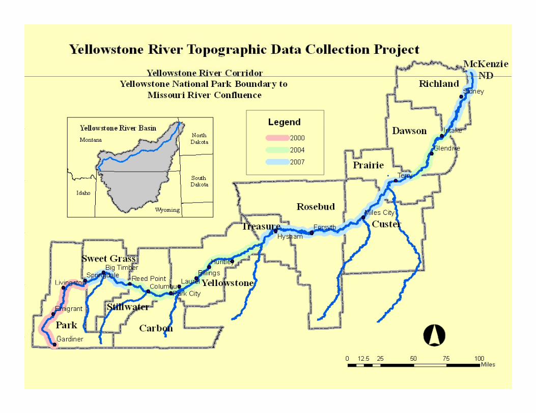
Association of Montana Floodplain ManagersAssociation of Montana Floodplain Managers
LiDARLiDARLiDARLiDARand other types of and other types of
Digital Terrain Model dataDigital Terrain Model datafor the Yellowstone River for the Yellowstone River
floodplainfloodplain
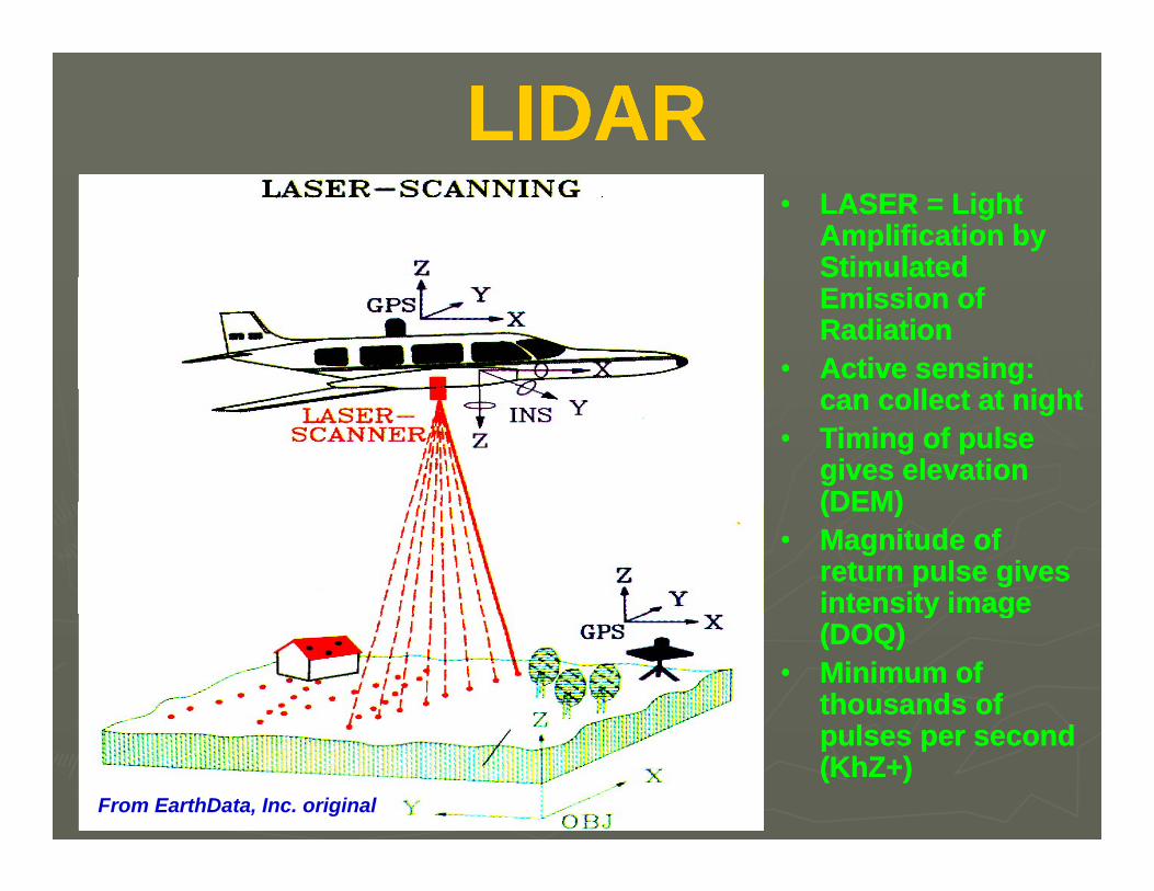
LIDARLIDARLIDARLIDAR•• LASER = Light LASER = Light
Amplification by Amplification by Stimulated Stimulated Emission of Emission of RadiationRadiation
•• Active sensing: Active sensing: ll t t i htll t t i htcan collect at nightcan collect at night
•• Timing of pulse Timing of pulse gives elevation gives elevation (DEM)(DEM)(DEM)(DEM)
•• Magnitude of Magnitude of return pulse gives return pulse gives intensity image intensity image y gy g(DOQ)(DOQ)
•• Minimum of Minimum of thousands of thousands of
l dl d
From EarthData, Inc. original
pulses per second pulses per second (KhZ+)(KhZ+)
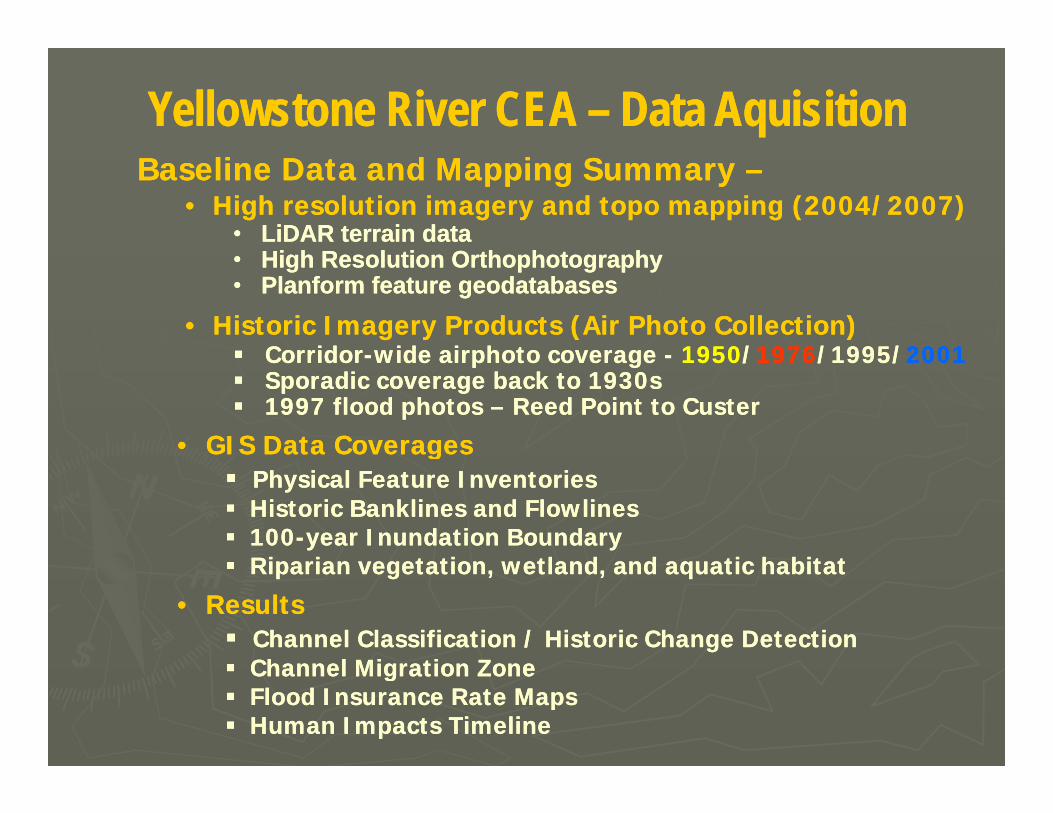
Yellowstone River CEA Yellowstone River CEA –– Data AquisitionData AquisitionBaseline Data and Mapping Summary Baseline Data and Mapping Summary ––
•• High resolution imagery and topo mapping (2004/2007)High resolution imagery and topo mapping (2004/2007)•• LiDAR terrain dataLiDAR terrain data
Hi h R l ti O th h t hHi h R l ti O th h t h•• High Resolution OrthophotographyHigh Resolution Orthophotography•• Planform feature geodatabasesPlanform feature geodatabases
•• Historic Imagery Products (Air Photo Collection)Historic Imagery Products (Air Photo Collection)CorridorCorridor--wide airphoto coveragewide airphoto coverage -- 19501950//19761976/1995//1995/20012001CorridorCorridor--wide airphoto coverage wide airphoto coverage -- 19501950//19761976/1995//1995/20012001Sporadic coverage back to 1930sSporadic coverage back to 1930s1997 flood photos 1997 flood photos –– Reed Point to CusterReed Point to Custer
•• GIS Data CoveragesGIS Data CoveragesggPhysical Feature InventoriesPhysical Feature InventoriesHistoric Banklines and FlowlinesHistoric Banklines and Flowlines100100--year Inundation Boundaryyear Inundation BoundaryRi i t ti tl d d ti h bit tRi i t ti tl d d ti h bit tRiparian vegetation, wetland, and aquatic habitatRiparian vegetation, wetland, and aquatic habitat
•• ResultsResultsChannel Classification / Historic Change DetectionChannel Classification / Historic Change DetectionChannel Migration ZoneChannel Migration ZoneChannel Migration ZoneChannel Migration ZoneFlood Insurance Rate MapsFlood Insurance Rate MapsHuman Impacts TimelineHuman Impacts Timeline
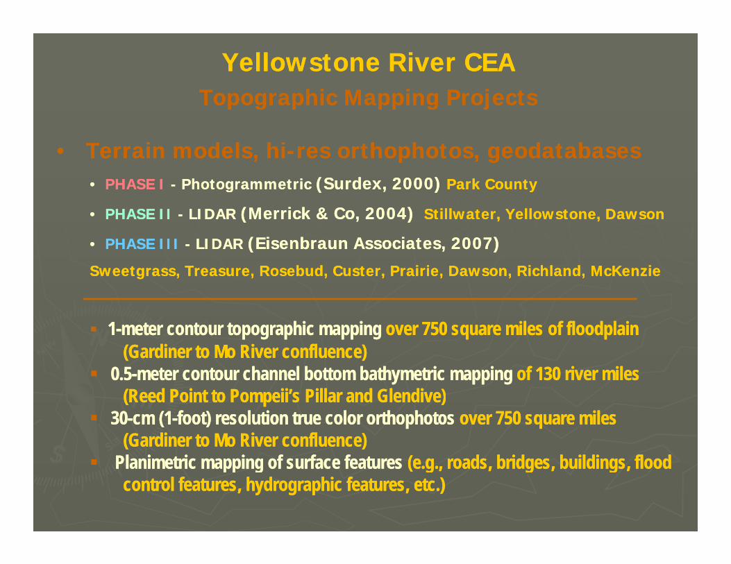
Yellowstone River CEAYellowstone River CEATopographic Mapping ProjectsTopographic Mapping ProjectsTopographic Mapping ProjectsTopographic Mapping Projects
•• Terrain models, hiTerrain models, hi--res orthophotos, geodatabasesres orthophotos, geodatabases•• PHASE IPHASE I -- Photogrammetric Photogrammetric (Surdex, 2000)(Surdex, 2000) Park CountyPark County
•• PHASE IIPHASE II -- LIDAR LIDAR (Merrick & Co, 2004)(Merrick & Co, 2004) Stillwater, Yellowstone, DawsonStillwater, Yellowstone, Dawson
•• PHASE IIIPHASE III -- LIDARLIDAR (Eisenbraun Associates, 2007)(Eisenbraun Associates, 2007)•• PHASE IIIPHASE III LIDAR LIDAR (Eisenbraun Associates, 2007)(Eisenbraun Associates, 2007)
Sweetgrass, Treasure, Rosebud, Custer, Prairie, Dawson, Richland, McKenzieSweetgrass, Treasure, Rosebud, Custer, Prairie, Dawson, Richland, McKenzie
11--meter contour topographic mappingmeter contour topographic mapping over 750 square miles of floodplain over 750 square miles of floodplain (Gardiner to Mo River confluence)(Gardiner to Mo River confluence)
0.50.5--meter contourmeter contour channel bottom bathymetric mappingchannel bottom bathymetric mapping of 130 river miles of 130 river miles ( G )( G )(Reed Point to Pompeii’s Pillar and Glendive)(Reed Point to Pompeii’s Pillar and Glendive)
3030--cm (1cm (1--foot) resolution true color orthophotosfoot) resolution true color orthophotos over 750 square miles over 750 square miles (Gardiner to Mo River confluence)(Gardiner to Mo River confluence)
Planimetric mappingPlanimetric mapping of surface featuresof surface features (e g roads bridges buildings flood (e g roads bridges buildings flood Planimetric mappingPlanimetric mapping of surface featuresof surface features (e.g., roads, bridges, buildings, flood (e.g., roads, bridges, buildings, flood control features, hydrographic features, etc.)control features, hydrographic features, etc.)
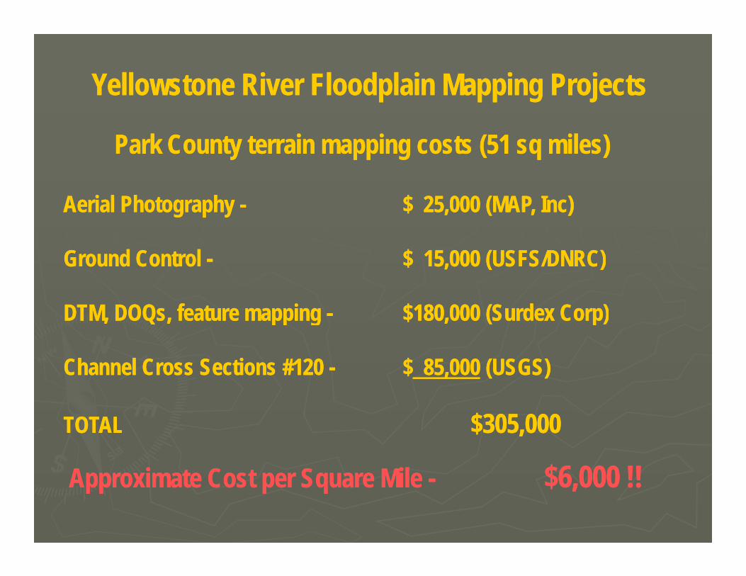
Yellowstone River Floodplain Mapping ProjectsYellowstone River Floodplain Mapping Projects
Park County terrain mapping costs (51 sq miles)Park County terrain mapping costs (51 sq miles)
Aerial Photography Aerial Photography -- $ 25,000 (MAP, Inc)$ 25,000 (MAP, Inc)
G d C t l G d C t l $ 15 000 (USFS/DNRC)$ 15 000 (USFS/DNRC)Ground Control Ground Control -- $ 15,000 (USFS/DNRC)$ 15,000 (USFS/DNRC)
DTM, DOQs, feature mapping DTM, DOQs, feature mapping -- $180,000 (Surdex Corp)$180,000 (Surdex Corp)pp gpp g ( p)( p)
Channel Cross Sections #120 Channel Cross Sections #120 -- $$ 85,00085,000 (USGS)(USGS)
TOTALTOTAL $305,000$305,000
A i t C t S Mil A i t C t S Mil $6 000 !!$6 000 !!Approximate Cost per Square Mile Approximate Cost per Square Mile -- $6,000 !!$6,000 !!
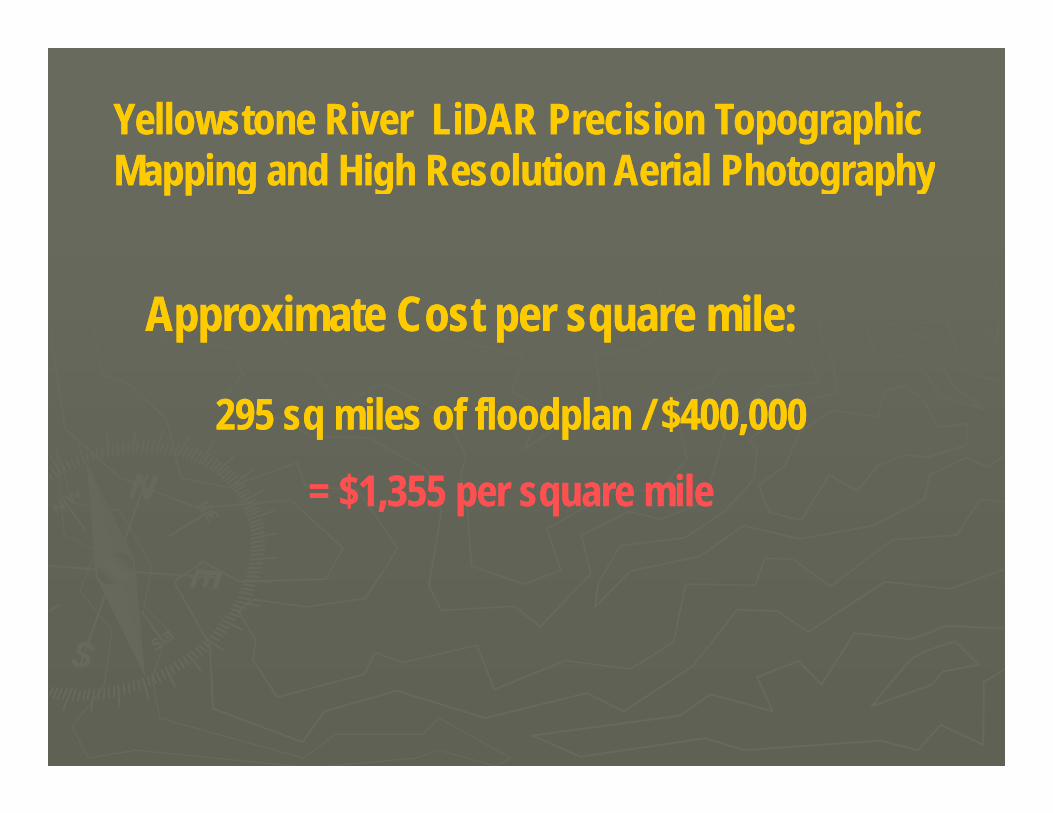
Yellowstone River LiDAR Precision Topographic Yellowstone River LiDAR Precision Topographic Mapping and High Resolution Aerial PhotographyMapping and High Resolution Aerial Photography
Approximate Cost per square mile:Approximate Cost per square mile:
295 sq miles of floodplan / $400,000295 sq miles of floodplan / $400,000
= $1,355 per square mile= $1,355 per square mile
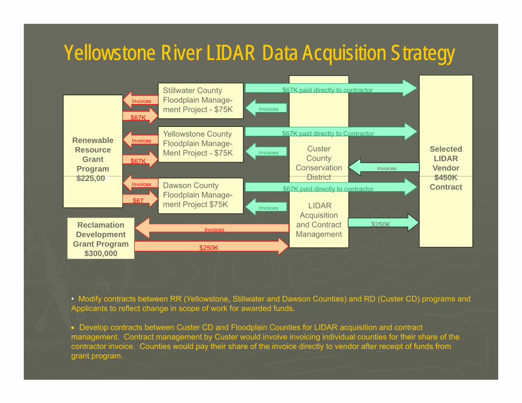
Yellowstone River LIDAR Data Acquisition StrategyYellowstone River LIDAR Data Acquisition StrategyStillwater County Floodplain Manage-ment Project - $75K
Invoices
$67KInvoices
$67K paid directly to contractor
RenewableResource
Grant Program$225 000
Yellowstone CountyFloodplain Manage-Ment Project - $75K Custer
County Conservation
District
SelectedLIDARVendor$450K
Invoices
$67KInvoices
$67K paid directly to Contractor
Invoices
$225,000
Reclamation
Dawson CountyFloodplain Manage-ment Project $75K
District
LIDAR Acquisition
and Contract
$450KContractInvoices
$67
$67K paid directly to contractor
Invoices
$250KReclamationDevelopment
Grant Program$300,000
and Contract Management
Invoices
$250K
$
• Modify contracts between RR (Yellowstone, Stillwater and Dawson Counties) and RD (Custer CD) programs and Applicants to reflect change in scope of work for awarded funds.
• Develop contracts between Custer CD and Floodplain Counties for LIDAR acquisition and contract• Develop contracts between Custer CD and Floodplain Counties for LIDAR acquisition and contract management. Contract management by Custer would involve invoicing individual counties for their share of the contractor invoice. Counties would pay their share of the invoice directly to vendor after receipt of funds from grant program.
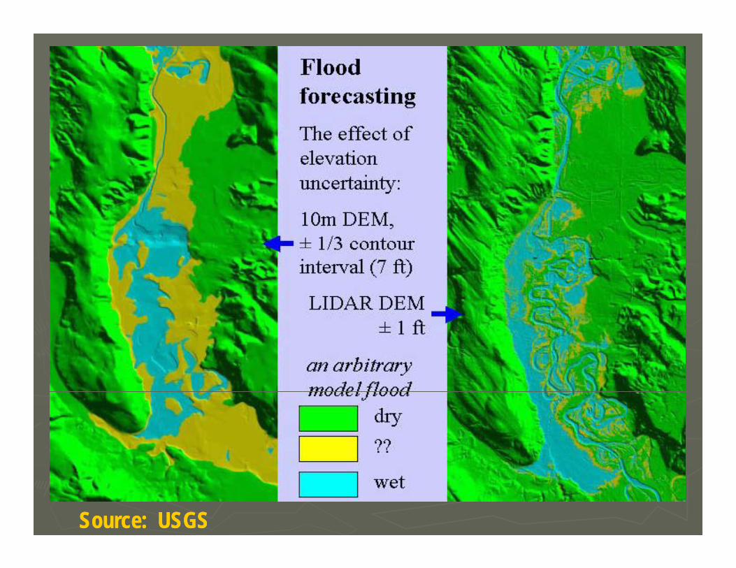
Source: USGSSource: USGS
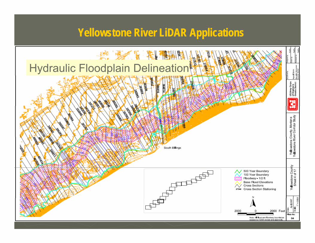
Yellowstone River LiDAR ApplicationsYellowstone River LiDAR Applications
Hydraulic Floodplain Delineation
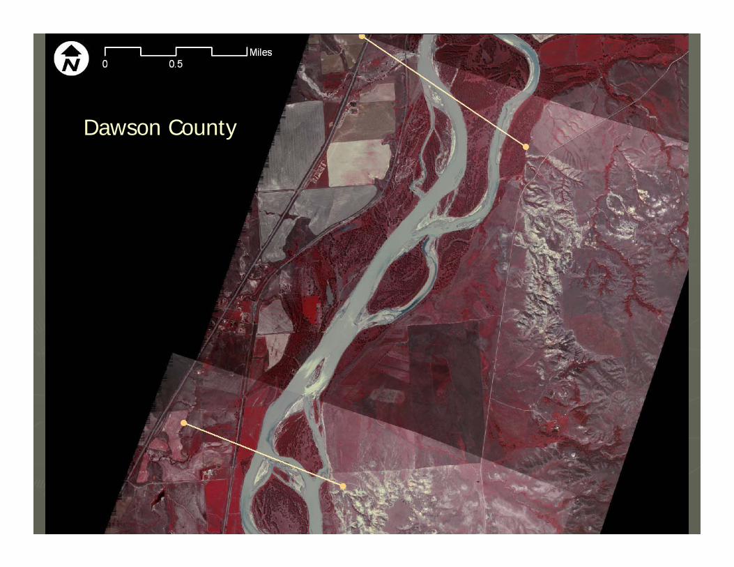
Dawson County
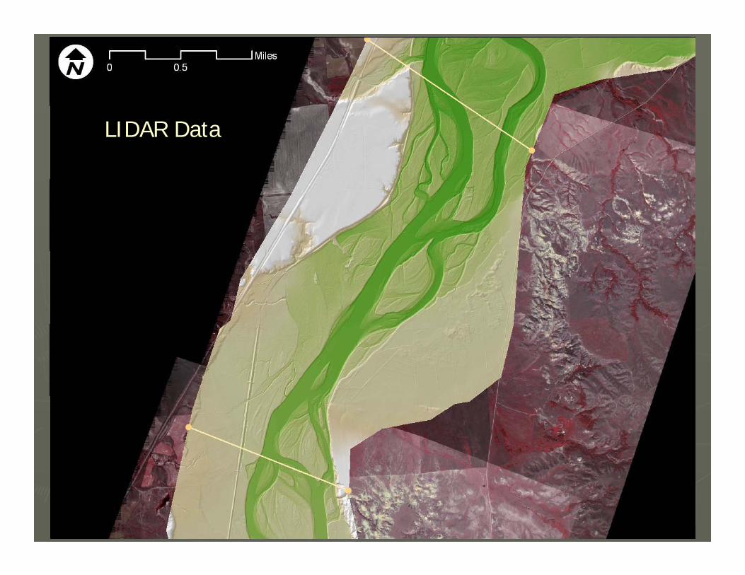
LIDAR Data
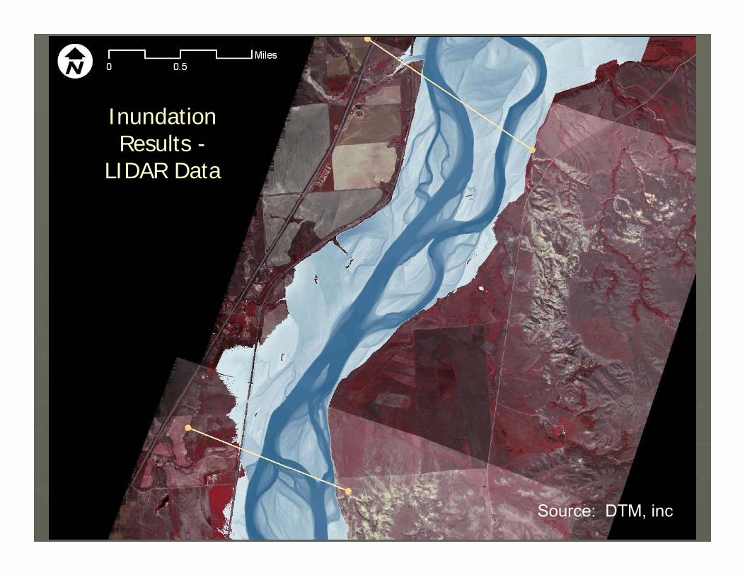
InundationResults -
LIDAR Data
Source: DTM, inc
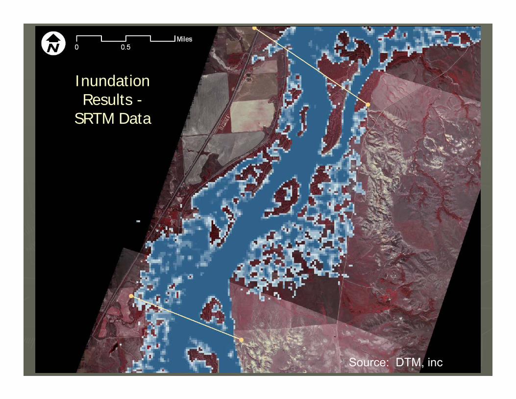
InundationResults -
SRTM Data
Source: DTM, inc
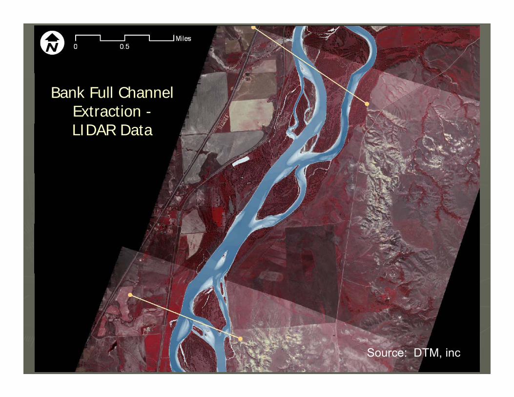
Bank Full Channel Extraction -LIDAR Data
Source: DTM, inc
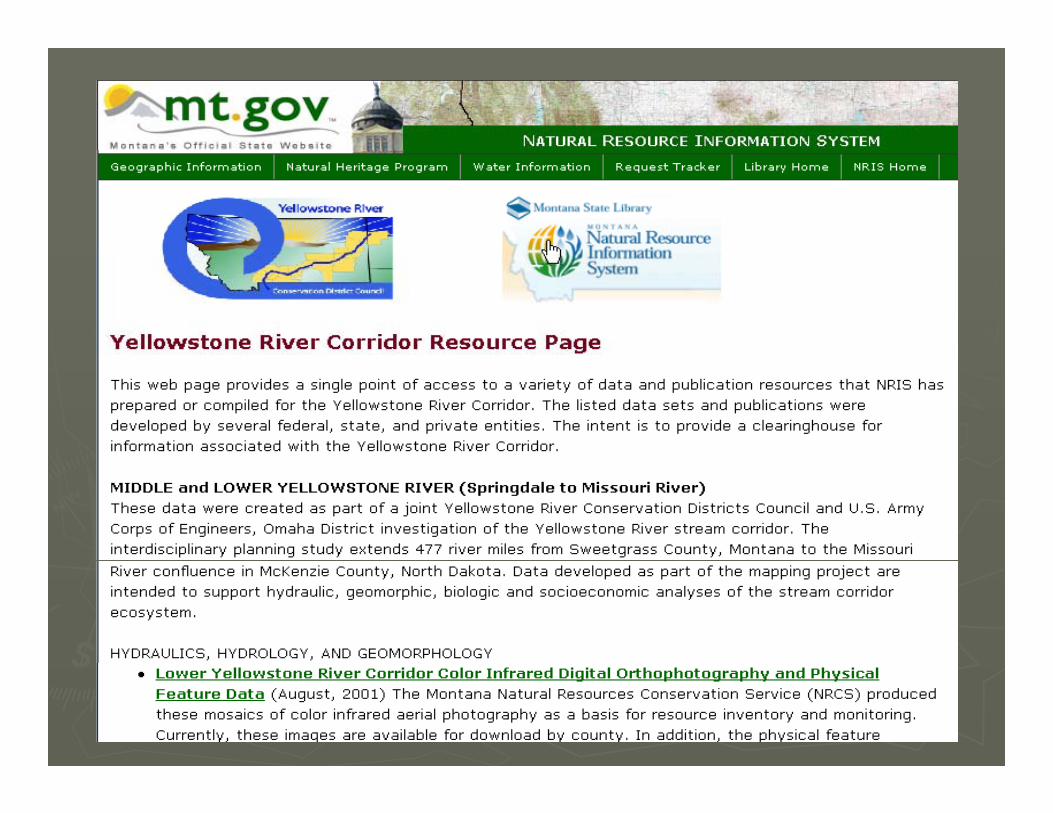
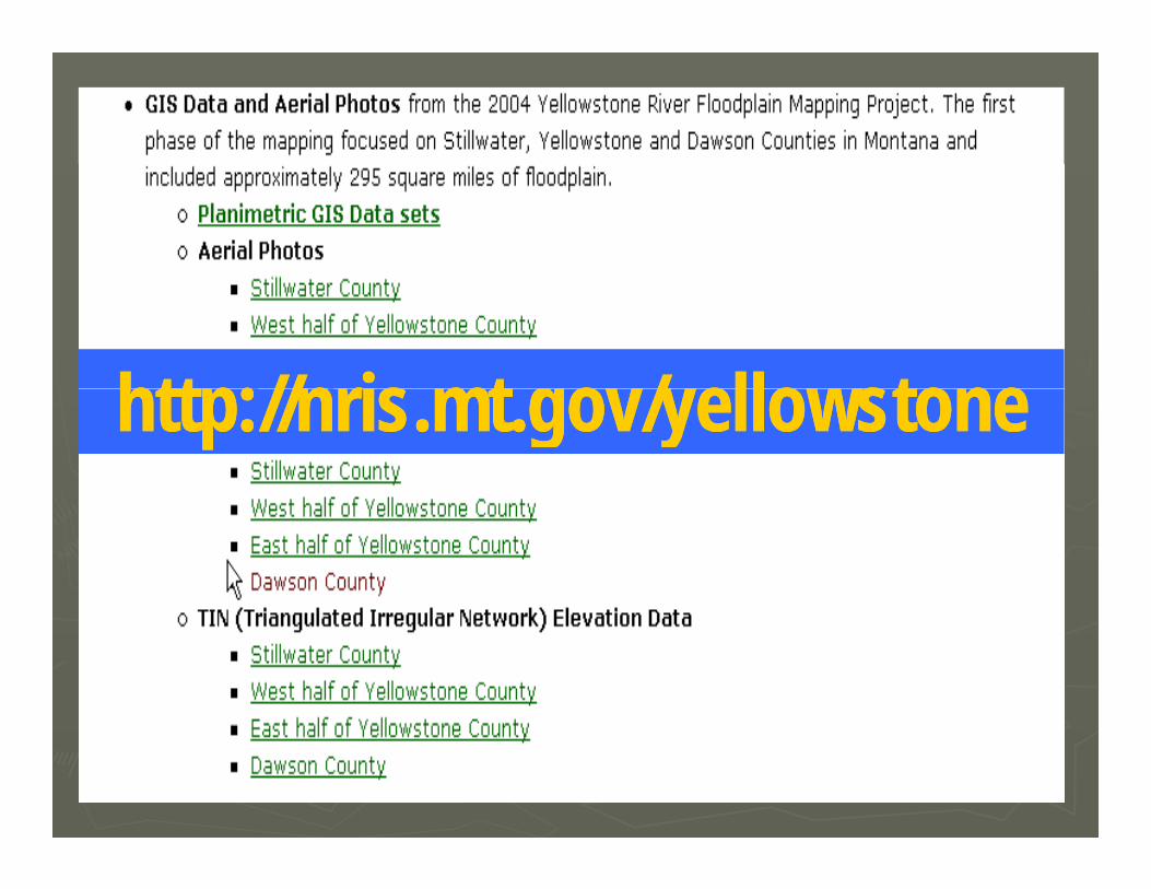
htt // i t / ll thtt // i t / ll thttp://nris.mt.gov/yellowstonehttp://nris.mt.gov/yellowstone
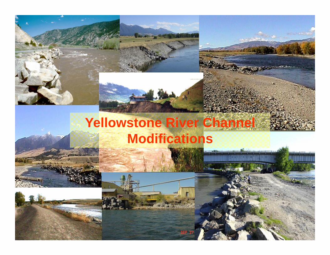
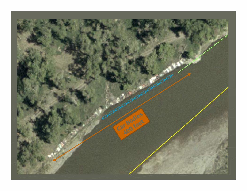
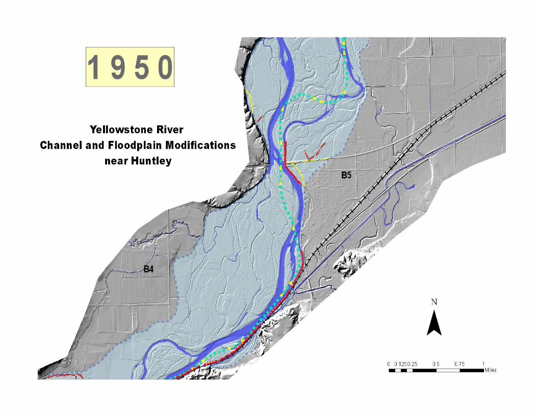
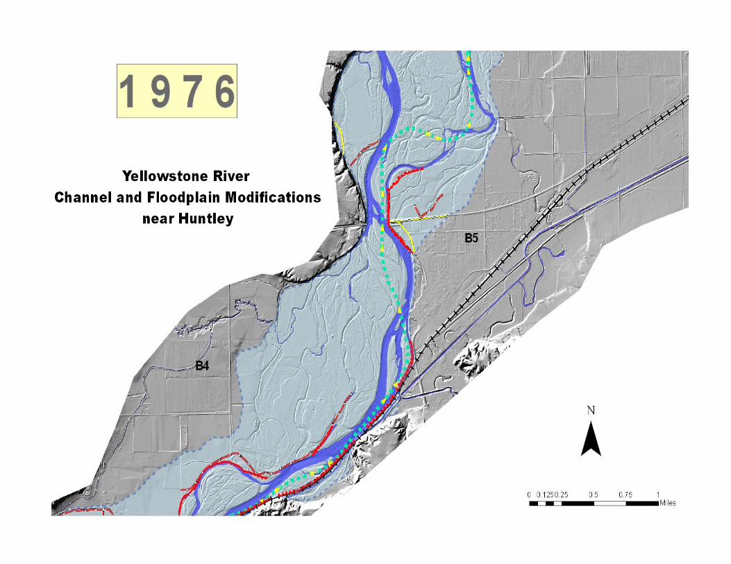
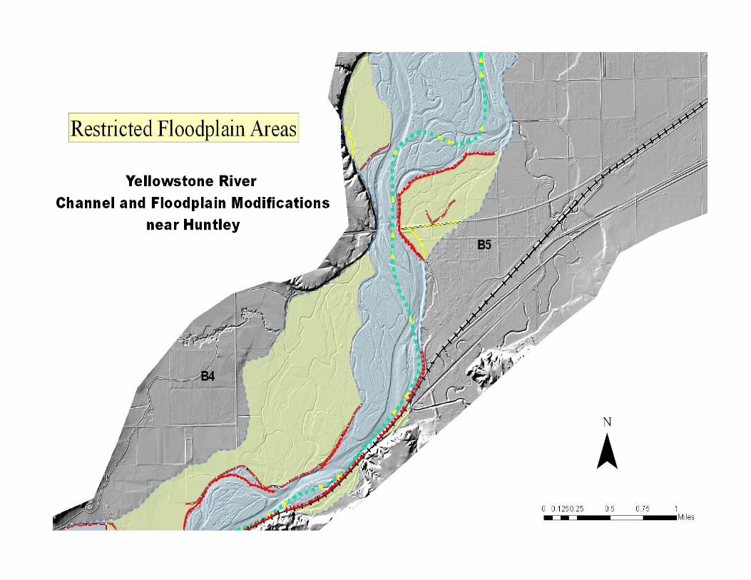
Yellowstone River Channel Modifications
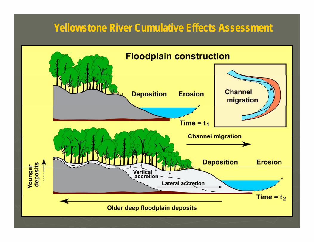
Yellowstone River Cumulative Effects AssessmentYellowstone River Cumulative Effects Assessment

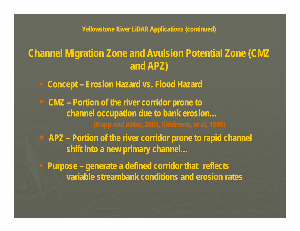
Yellowstone River LiDAR Applications (continued)Yellowstone River LiDAR Applications (continued)
Channel Migration Zone and Avulsion Potential Zone (CMZ Channel Migration Zone and Avulsion Potential Zone (CMZ and APZ)and APZ)
CMZ CMZ Portion of the river corridor prone to Portion of the river corridor prone to
Concept Concept –– Erosion Hazard vs. Flood HazardErosion Hazard vs. Flood Hazard
CMZ CMZ –– Portion of the river corridor prone to Portion of the river corridor prone to channel occupation due to bank erosion…channel occupation due to bank erosion…
(Rapp and Abbe, 2003, Skidmore, et al, 1999)(Rapp and Abbe, 2003, Skidmore, et al, 1999)
APZ APZ –– Portion of the river corridor prone to rapid channel Portion of the river corridor prone to rapid channel shift into a new primary channel…shift into a new primary channel…
Purpose Purpose –– generate a defined corridor that generate a defined corridor that reflects reflects variable streambank conditions and erosion ratesvariable streambank conditions and erosion rates
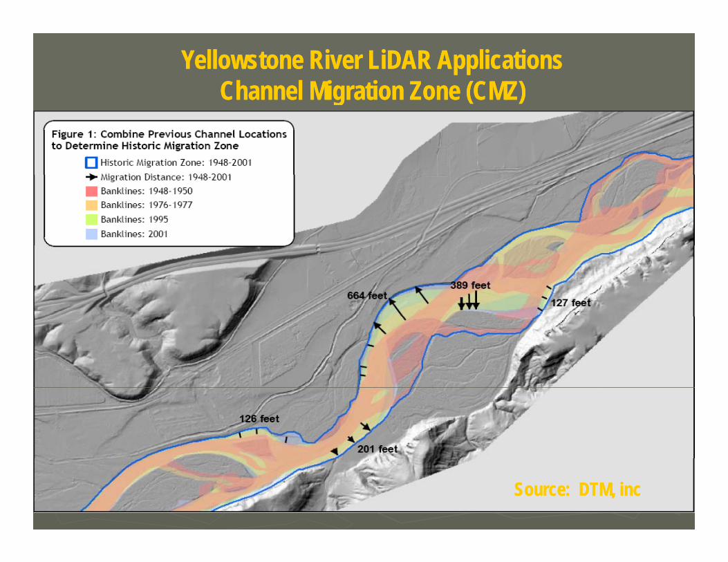
Yellowstone River LiDAR ApplicationsYellowstone River LiDAR ApplicationsChannel Migration Zone (CMZ)Channel Migration Zone (CMZ)g ( )g ( )
Source: DTM, incSource: DTM, inc
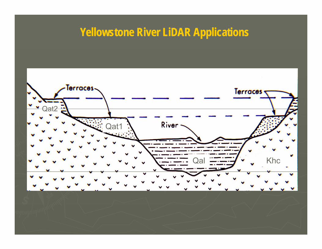
Yellowstone River LiDAR ApplicationsYellowstone River LiDAR Applications
Qat2
Qat1
Qat2
Qal Khc
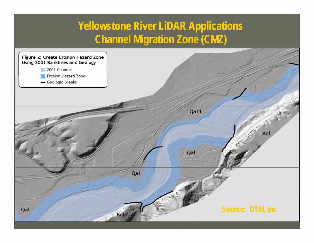
Yellowstone River LiDAR ApplicationsYellowstone River LiDAR ApplicationsChannel Migration Zone (CMZ)Channel Migration Zone (CMZ)g ( )g ( )
Source: DTM, incSource: DTM, inc
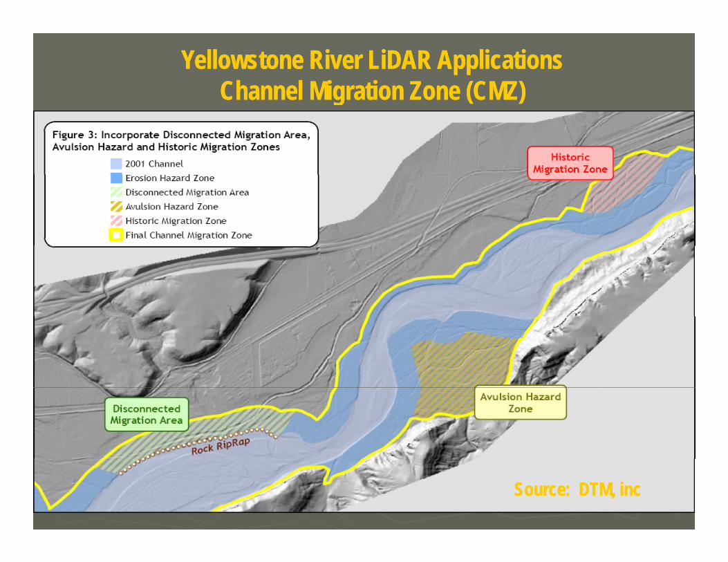
Yellowstone River LiDAR ApplicationsYellowstone River LiDAR ApplicationsChannel Migration Zone (CMZ)Channel Migration Zone (CMZ)g ( )g ( )
Source: DTM, incSource: DTM, inc
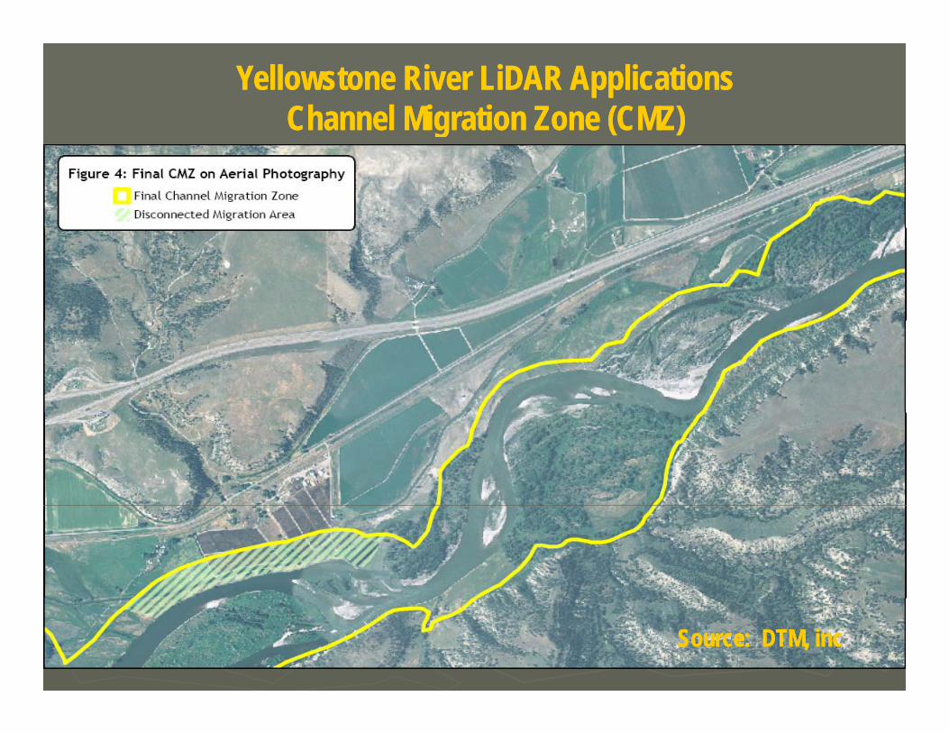
Yellowstone River LiDAR ApplicationsYellowstone River LiDAR ApplicationsChannel Migration Zone (CMZ)Channel Migration Zone (CMZ)g ( )g ( )
Source: DTM, incSource: DTM, inc
Yellowstone River Cumulative Effects Assessment Yellowstone River Cumulative Effects Assessment and LiDAR Applicationsand LiDAR Applications
P j S & MP j S & M T h i l S i P idT h i l S i P id
ppppAcknowlegementsAcknowlegements
►► Project Sponsors & Management:Project Sponsors & Management:Governor’s Upper Yellowstone River Task Governor’s Upper Yellowstone River Task ForceForce
►► Technical Service Providers:Technical Service Providers:DTM Consulting, Inc.DTM Consulting, Inc.
Bozeman, MontanaBozeman, Montana
Yellowstone River Conservation District Yellowstone River Conservation District CouncilCouncilU.S. Army Corps of Engineers, Omaha U.S. Army Corps of Engineers, Omaha Di t i tDi t i t
Applied Geomorphology, Inc. Applied Geomorphology, Inc. Bozeman, MontanaBozeman, Montana
Merrick and Company, Merrick and Company, A C l dA C l dDistrictDistrict
MT DNRC, Reclamation and Development MT DNRC, Reclamation and Development Grant ProgramGrant Program
Aurora, ColoradoAurora, ColoradoEisenbraun & Associates,Eisenbraun & Associates,
Yankton, South DakotaYankton, South Dakota
Stillwater, Yellowstone, and Dawson Stillwater, Yellowstone, and Dawson CountiesCounties
U.S. Army Corps, Omaha DistrictU.S. Army Corps, Omaha District
MT DNRC, Water Resources and MT DNRC, Water Resources and Conservation and Resource Conservation and Resource Development DivisionsDevelopment DivisionsDevelopment DivisionsDevelopment Divisions
http://nris.mt.gov/yellowstone