Embed Size (px)
Citation preview
Project Narrative
PAD Rezone Narrative
Case No. RZ19-02
Northwest of Perryville Road
and McDowell Road
1st Submittal: May 15, 2019
2nd Submittal: July 31, 2019
3rd Submittal: August 22, 2019
Paloma Vista
1 | P a g e
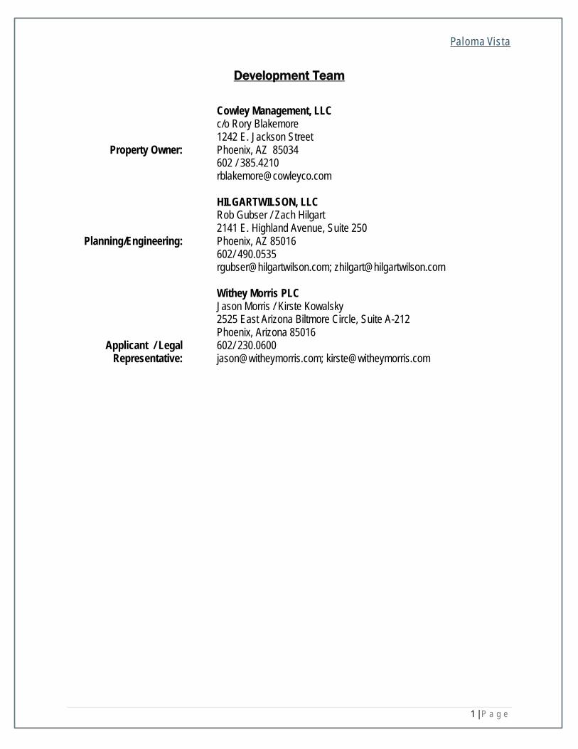
Development Team
Property Owner:
Cowley Management, LLC c/o Rory Blakemore 1242 E. Jackson Street Phoenix, AZ 85034 602 / 385.4210 [email protected]
Planning/Engineering:
HILGARTWILSON, LLC Rob Gubser / Zach Hilgart 2141 E. Highland Avenue, Suite 250 Phoenix, AZ 85016 602/ 490.0535 [email protected]; [email protected]
Applicant / Legal Representative:
Withey Morris PLC Jason Morris / Kirste Kowalsky 2525 East Arizona Biltmore Circle, Suite A-212 Phoenix, Arizona 85016 602/ 230.0600 [email protected]; [email protected]
Paloma Vista
2 | P a g e
Table of Contents
A. Introduction ............................................................................................................................................ 3
B. Property Description .............................................................................................................................. 3
C. Current Property Entitlements ............................................................................................................... 4
D. Proposed Land Use Designation ........................................................................................................... 4
E. Proposed General Plan Land Use Designations ................................................................................... 5
F. Proposed Zoning District with PAD Overlay & Uses .............................................................................. 5
G. Plans for Development ........................................................................................................................... 7
H. Conclusion ........................................................................................................................................... 10
I. Exhibit Tabs ......................................................................................................................................... 12
Paloma Vista
3 | P a g e
A. INTRODUCTION
Withey Morris, PLC, on behalf of property owner (“Cowley Management LLC”) is processing a Planned Area
Development (“PAD”) rezoning application for the approximately 163 gross/155 net acre vacant site located
northwest of Perryville Road and McDowell Road (the “Property”) in the City of Buckeye. The Property is
comprised of two (2) parcels (APN(s): 502-65-006T and 502-65-006M). See TAB 1, Aerial Vicinity Map
and TAB 2, Legal Description.
This request, which is referenced as “Paloma Vista”, is companion to a Minor General Plan Amendment
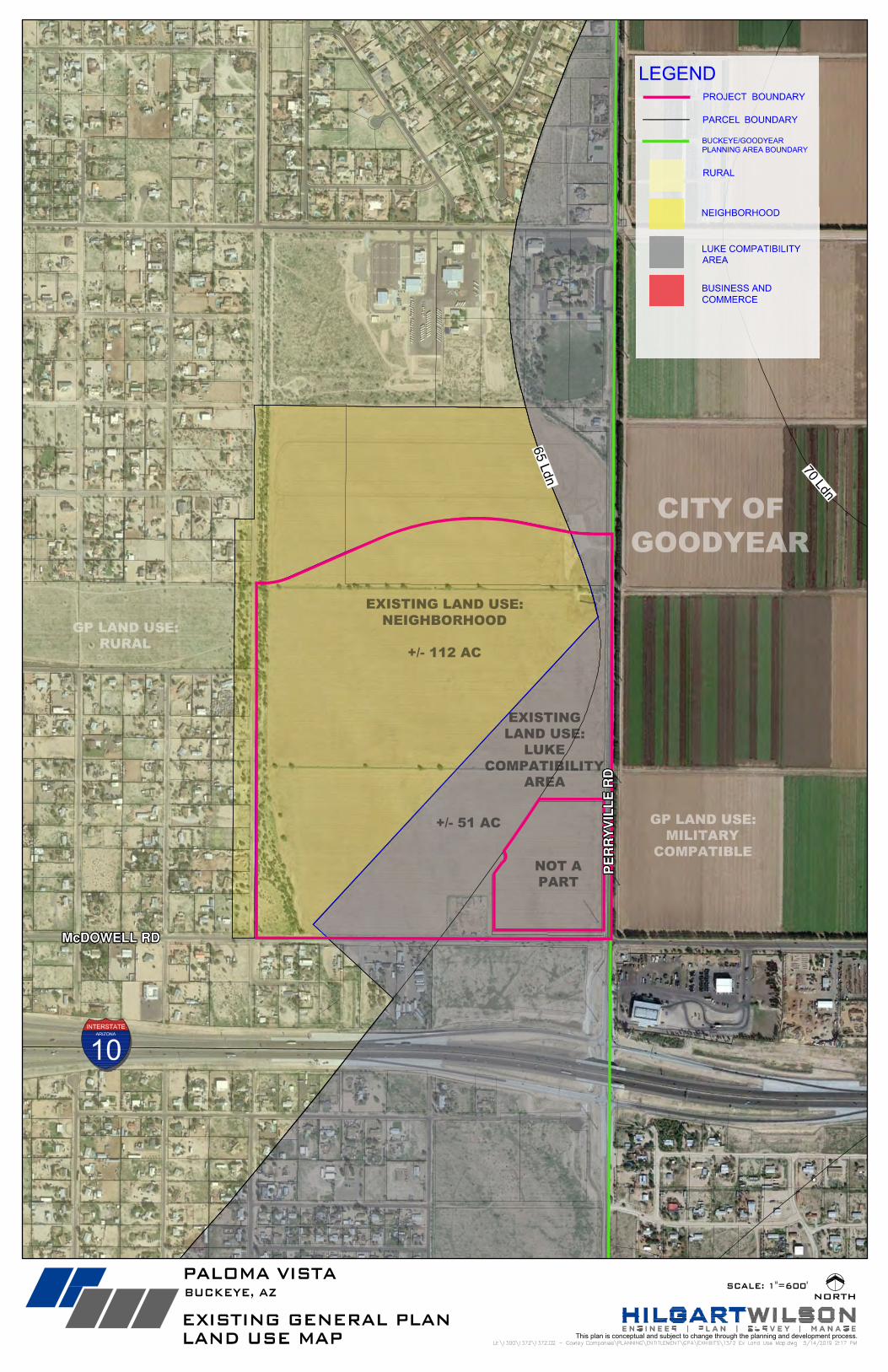
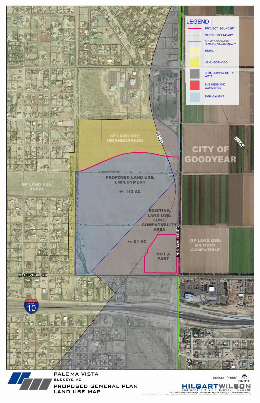
(“GPA”) request that seeks to change approximately 112 gross acres of existing Neighborhood land use to
Employment land use in order to allow for industrial uses. The City’s adopted 2040 General Plan Land Use
Map designates approximately 112-acres of the Property as Neighborhood land use with the remaining
portion of the Property closest to the arterial intersection as Luke Compatibility Area (“LCA”) land use. This
proposal to amend the existing Neighborhood land use to Employment use is far more compatible with the
allowed uses which fall under the 65 ldn noise contour as well as the city’s General Plan goals and polices
recommended for the LCA. It also recommended that a Planned Area Development (PAD) zoning
accommodates larger development requests for a variety of business services and employment uses. See
TAB 3, Existing and Proposed General Plan.
B. PROPERTY DESCRIPTION
The Property is approximately 163 gross/155 net acres of unimproved land located northwest of Perryville
Road and McDowell Road. Two regionally significant roadways serve the Property: Perryville Road (Major
Arterial) and McDowell Road (Parkway). The Property has an excellent positioning for employment-related
industrial uses, as it is close to two freeway transportation corridors including the I-10 Freeway (less than 1
mile to the south) and 303 Freeway (2 miles to the east). In fact, the Property is located just north and less
than 1,000-feet from the I-10 Freeway access ramp.
The Property has historically been used for agricultural purposes and is relatively flat, with a gradual slope to
the southeast at approximately 0.8%. Along the western boundary of the Property, there is an existing special
flood hazard area according to FEMA maps which designates this floodway area as Zone AE. Due to this
designation and flow patterns, there are several drainage channels that convey off-site flows along the
western boundary and near the northeastern corner of the site. A more detailed drainage analysis is provided
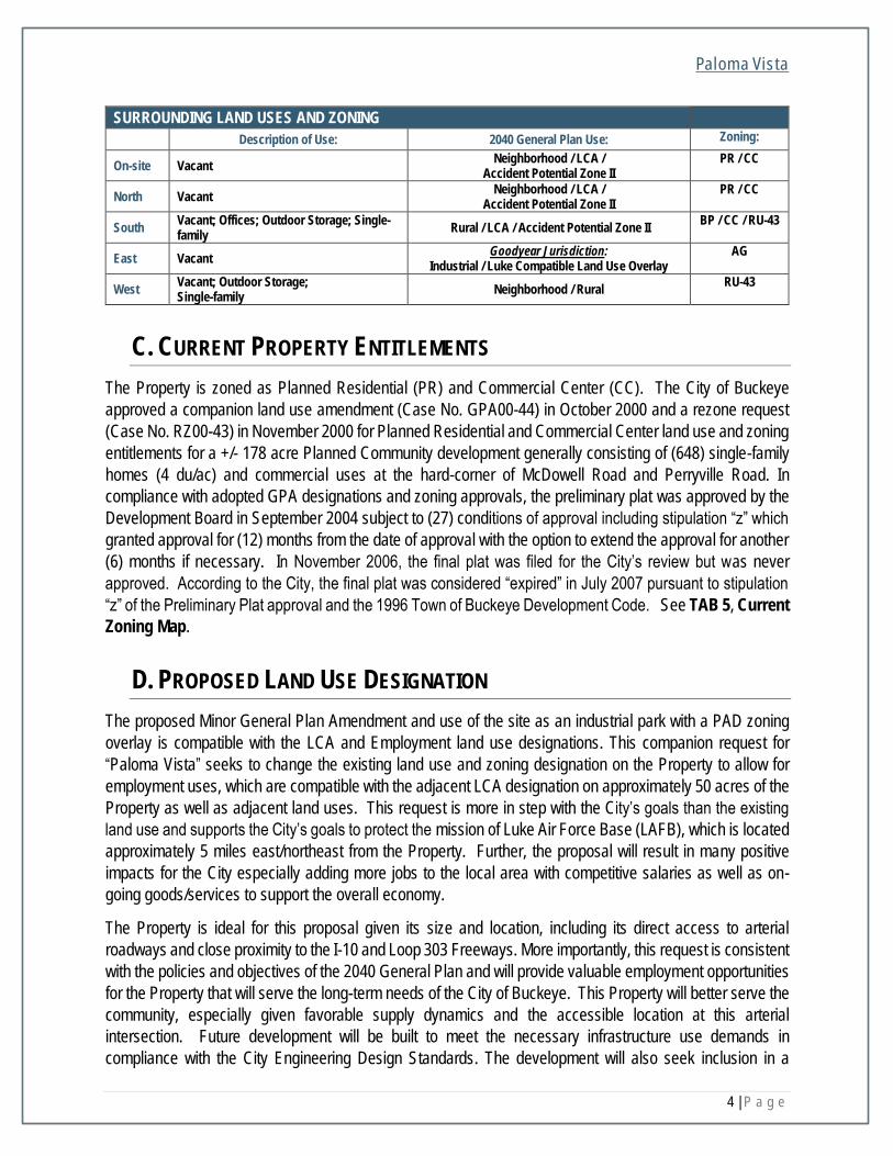
in Section G: Drainage below. The Property is adjacent to a combination of uses as detailed in the table
below and shown as referenced at TAB 4, Area and Land Use Plan.
Table on following page
Paloma Vista
4 | P a g e
SURROUNDING LAND USES AND ZONING
Description of Use: 2040 General Plan Use: Zoning:
On-site Vacant Neighborhood / LCA /
Accident Potential Zone II PR / CC
North Vacant Neighborhood / LCA /
Accident Potential Zone II PR / CC
South Vacant; Offices; Outdoor Storage; Single-family
Rural / LCA / Accident Potential Zone II BP / CC / RU-43
East Vacant Goodyear Jurisdiction:
Industrial / Luke Compatible Land Use Overlay AG
West Vacant; Outdoor Storage; Single-family
Neighborhood / Rural RU-43
C. CURRENT PROPERTY ENTITLEMENTS
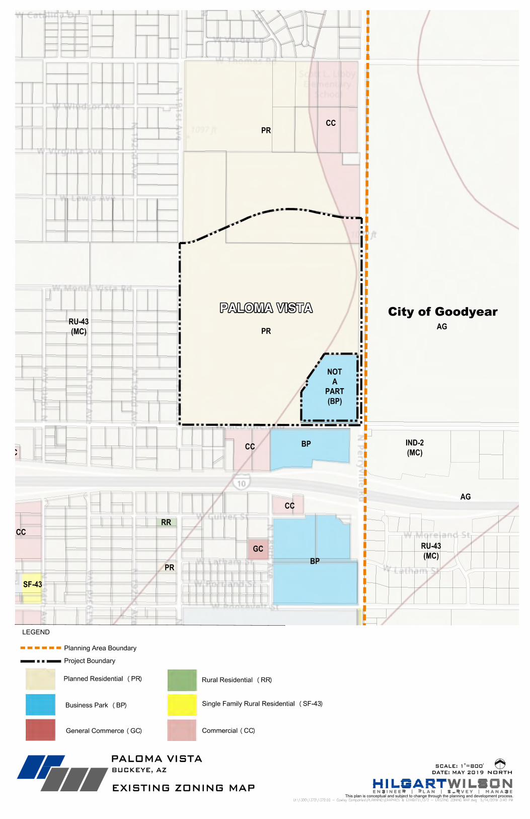
The Property is zoned as Planned Residential (PR) and Commercial Center (CC). The City of Buckeye
approved a companion land use amendment (Case No. GPA00-44) in October 2000 and a rezone request
(Case No. RZ00-43) in November 2000 for Planned Residential and Commercial Center land use and zoning
entitlements for a +/- 178 acre Planned Community development generally consisting of (648) single-family
homes (4 du/ac) and commercial uses at the hard-corner of McDowell Road and Perryville Road. In
compliance with adopted GPA designations and zoning approvals, the preliminary plat was approved by the
Development Board in September 2004 subject to (27) conditions of approval including stipulation “z” which
granted approval for (12) months from the date of approval with the option to extend the approval for another
(6) months if necessary. In November 2006, the final plat was filed for the City’s review but was never
approved. According to the City, the final plat was considered “expired” in July 2007 pursuant to stipulation
“z” of the Preliminary Plat approval and the 1996 Town of Buckeye Development Code. See TAB 5, Current
Zoning Map.
D. PROPOSED LAND USE DESIGNATION
The proposed Minor General Plan Amendment and use of the site as an industrial park with a PAD zoning
overlay is compatible with the LCA and Employment land use designations. This companion request for
“Paloma Vista” seeks to change the existing land use and zoning designation on the Property to allow for
employment uses, which are compatible with the adjacent LCA designation on approximately 50 acres of the
Property as well as adjacent land uses. This request is more in step with the City’s goals than the existing
land use and supports the City’s goals to protect the mission of Luke Air Force Base (LAFB), which is located
approximately 5 miles east/northeast from the Property. Further, the proposal will result in many positive
impacts for the City especially adding more jobs to the local area with competitive salaries as well as on-
going goods/services to support the overall economy.
The Property is ideal for this proposal given its size and location, including its direct access to arterial
roadways and close proximity to the I-10 and Loop 303 Freeways. More importantly, this request is consistent
with the policies and objectives of the 2040 General Plan and will provide valuable employment opportunities
for the Property that will serve the long-term needs of the City of Buckeye. This Property will better serve the
community, especially given favorable supply dynamics and the accessible location at this arterial
intersection. Future development will be built to meet the necessary infrastructure use demands in
compliance with the City Engineering Design Standards. The development will also seek inclusion in a
Paloma Vista
5 | P a g e
Revitalization District and phasing of infrastructure may be subject to Revitalization District phasing and/or
funding requirements. The placement of these proposed uses, in conjunction with site buffering, will mitigate
impacts on adjacent residential development. All uses will be designed to efficiently circulate vehicular traffic
and promote a safe interface with pedestrian and bicycle circulation based upon the City’s approval of a
future site plan(s) for a specific user(s).
E. PROPOSED GENERAL PLAN LAND USE DESIGNATIONS
The current General Plan designates a majority of the Property for Neighborhood land use. The remaining
+/- 50 acres of the southeast corner of the Property nearest the arterial intersection is designated as Luke
Compatibility Area (“LCA”). The companion Minor General Plan Amendment seeks to amend the existing
land use and introduce the Employment designation for a portion of the total +/- 112 acre Property in order
to create meaningful opportunities for a wide variety of future employment-related uses that are compatible
with the intensity and permitted uses of the adjacent LCA designation for the Property. This proposal has
strategically considered appropriate intensities for future development, which will include buffering techniques
that protect existing neighborhoods as well as create better synergy with the overall area.
The proposal will activate a large, underutilized parcel with industrial and other employment-related uses
which are consistent with the mixed intensity of the surrounding area. Further, this request will have a positive
impact on the community as future development will be compatible with the character of the area including
the planned industrial areas designated for the parcels east of Perryville Road (within Goodyear’s
jurisdiction). The types of land uses, access points, and approach to providing a seamless land transition
within the Property have been thoughtfully considered to respect the manner and development standards of
the surrounding uses. This application meets the City’s goals for providing a variety of employment options
to support a vibrant community, including providing greater employment opportunities within close proximity
to existing and planned residential developments in the City of Buckeye.
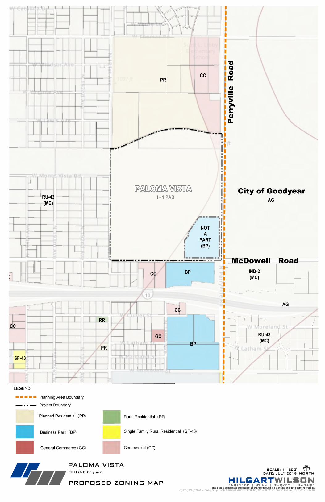
F. PROPOSED ZONING DISTRICT WITH PAD OVERLAY & USES
This request to rezone the Property from Planned Residential (which is an obsolete zoning district) and
Community Commercial to Industrial (I-1) with a PAD overlay is consistent with the city’s goals for providing
additional employment to the city and protecting the mission and operations of Luke Air Force Base (“LAFB”).
The PAD overlay is consistent with the General Plan and the requested Employment land use category.
Moreover, the Property is impacted by the LAFB flight path overlay, which supports the rezoning of this
Property.
The site will be designed in accordance with the City of Buckeye Development Code, with respect to
development standards, engineering design standards, open space requirements, zoning stipulations and
other site and building design standards. TAB 5, Proposed Zoning Map.
Light Industrial (I-1)): “The I-1 district is intended to provide for light manufacturing, warehousing, processing, service, storage, wholesale, distribution operations, and research and development
uses, with all operations contained within an enclosed building.”
Land uses within Paloma Vista shall be governed by the Permitted and Conditional Uses within the I-1 zoning
district and further described in Article 3: Use Regulations of the City of Buckeye Development Code. In the
Paloma Vista
6 | P a g e
event there is an absence of a specific regulation in the PAD, the City of Buckeye Development Code shall
apply. Where the regulations in the PAD and the City of Buckeye Development Code conflict, the more
restrictive regulation shall apply. Due to the proximity to LAFB and the need for additional employment
opportunities in this vicinity, Paloma Vista allows for light manufacturing, warehousing, processing, service,
storage, wholesale, distribution operations, and research and development uses which will be contained
within an enclosed building(s). In addition to the uses contained in the I-1 zoning district, the following uses
may be permitted.
Allowed Uses:
a. Office, business or professional
b. All uses allowed by ARS § 28-8481 pursuant to the Luke Air Force Base Flight Path
The proposal also considers the presence of adjacent residential county islands along the western boundary
of the Property. Therefore, Paloma Vista prohibits within the entirety of the Property, the following uses that
are less desirable adjacent to residential.
Prohibited Uses:
a. Medical Marijuana Dispensary
b. Medical Marijuana Dispensary Offsite Cultivation Location
c. Airport
d. Heliport
e. Bus terminal
f. Solar generation station
g. Dairy
h. Meat Processing
i. Check Cashing
j. Major entertainment facility, outdoor
k. Open-air market or flea market
l. Open air/outdoor storage uses except in connection with a business being conducted within a
building
m. Nursery and plant sales, wholesale
n. Sexually oriented business
o. Truck Stop
p. Hospital
q. Motor Freight Terminal
r. Shelter Care Facility, Homeless
s. Cemetery
t. Crematorium
u. Recycling Center
v. Day Care, commercial
w. Any residential or business with overnight stays
x. All uses prohibited by ARS § 28-8481 pursuant to the Luke Air Force Base Flight Path
Paloma Vista
7 | P a g e
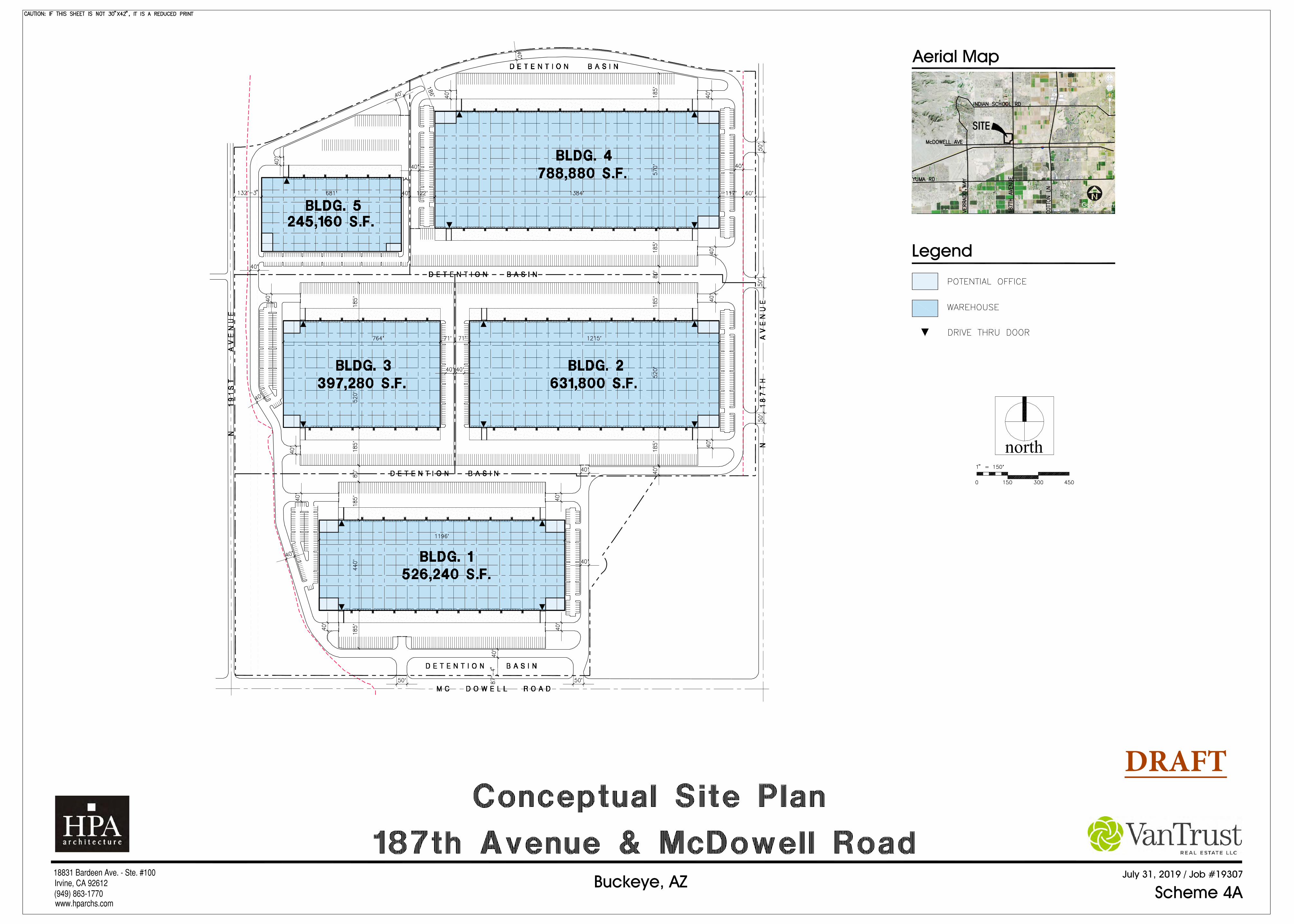
G. PLANS FOR DEVELOPMENT
Conceptual Site Plan
The Property, which is comprised of two parcels, is currently owned by one property owner. The goal is to
develop the property as either as one large development or, if needed, on separately platted lots for each
building based on how the buildings are actually developed for specific end user(s). A Concept Site Plan is
part with this rezoning request. The applicant understands that this site plan is conceptual only and that final
site plan approval will be submitted to the City of Buckeye for administrative review and approval at a future
date. TAB 6, Conceptual Site Plan.
The Development Standards for the Site will be those identified in Section 4.1.3 of the Buckeye Development
Code for I-1 uses, except as modified in the table below:
Paloma Vista PAD Overlay Development Standards PAD I-1 District
Lot Coverage, maximum (percent) 80 80
Setbacks, minimum (feet)
Setback from arterial: 40, peripheral property line: 20
Adjacent to residential district*: 50
Setback from arterial: 40, adjacent to residential: 75,
others 20.
Building Height, maximum (feet)
60 at setback; increase 1ft for every 3ft in additional setback to max of 120.
55 at setback; increase 1ft for every 3ft in additional setback to max of 120.
* Western property line to face of building shall be no less than 100-feet.
The building setback along the western boundary of the site was increased to provide additional buffering
from adjacent residential properties. The site plan, conceptual grading and drainage, landscape plans and
architectural renderings that will be submitted as part of the Site Plan will demonstrate that the Project will be
an aesthetically pleasing industrial park with architecture compatible with comparable industrial parks in the
area. The final site plan and building lay out will be developed according to specific users and their
requirements, and shall meet or exceed minimum standards for landscape and open space, per the City of
Buckeye Development Code.
As noted above, future plans will further show that berming, screen walls and dense landscaping will be used
to screen the Project and its loading and other light industrial associated activities from the neighboring
residential uses where appropriate. Additionally, any proposed lighting on site will be screened and shielded
in accordance with the City of Buckeye’s requirements to minimize light spillage.
Off-Street Parking
All off-street parking shall be meet the minimum requirements per the City of Buckeye Development Code,
except for office or administrative areas associated with an Industrial Use shall be parked at 1 space per 500
square feet.
Paloma Vista
8 | P a g e
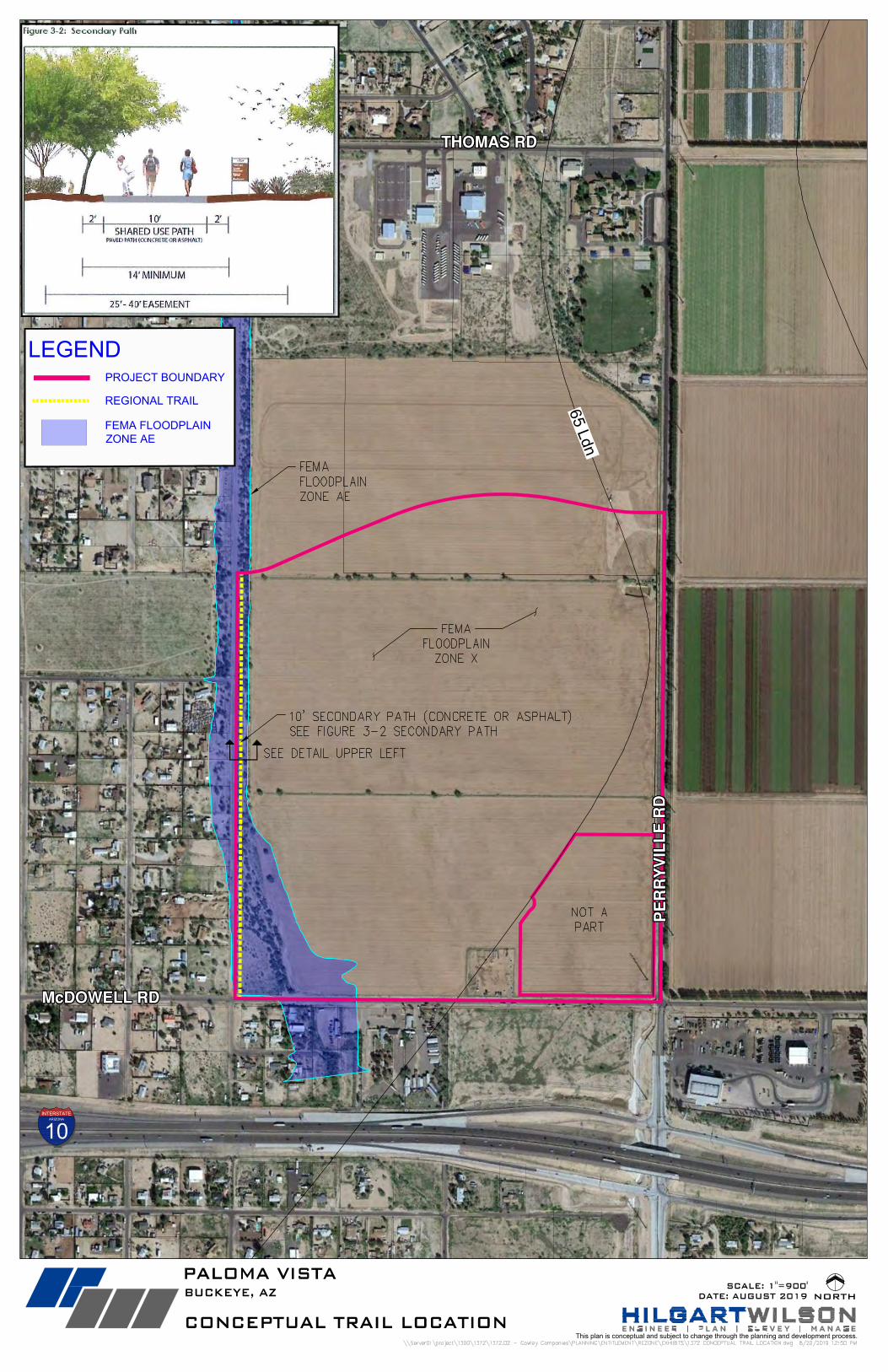
Trails
Buckeye City Council adopted the Parks and Recreation Master Plan in 2016, which provides the
requirements for parks, trails and open space for development. See TAB 7, Secondary Pathway Exhibit.
In accordance with the approved Parks and Recreations Master Plan, future development of the Property will
provide a 10’ wide path within a minimum 25’ easement located in the 75’ landscape area along the western
boundary of the site based on the following requirements:
Path/Trail Name Path Width Surface Parallel Surface Recommended Easement Width
Sedondary Path 10’ Concrete or Asphalt None Required 25’ - 40’
Note: The development of the path will comply with other planning standards and gidelines included in the City’s Parks
and Recreation Master Plan. The final location of the trail will be set forth on the approved site plan.
Design Requirements
In addition to the design requirements contained within the City of Buckeye Development Code, the following
additional landscaping and design requirements shall be required at the time the Property is developed:
1. The perimeter landscape buffer along any adjacent ROW shall be at least 20 feet as measured from
the back of the adjacent curb, with the exception of the western property boundary, where a 75’
landscape area (within which the FEMA floodway and trail easement will be located) will be provided.
Said landscaping shall include a combination of earthen drainage channels, berms, screen walls,
and/or lush landscaping as to allow screening, buffering and noise reduction as feasible.
2. Building public entries (excluding employee and fire access entries) will be enhanced with horizontal
and vertical offsets to provide interest in the massing and will include storefront glass at the office
areas with overhead steel accent canopies to provide shade and shadow.
3. In addition to the combination of landscaping and berming around the perimeter of the site, exterior
areas used for loading and unloading of trailers will be set back from the project perimeter by a
minimum of 50 feet as measured from property line and screened from public right-of-way by an
eight (8) foot high wall that will include a combination of materials and earth toned colors as well as
wall articulation, as required in Development Code Section 5.4.5.
Drainage
Final drainage design for future development shall comply with the City of Buckeye engineering standards.
The region surrounding the Property generally drains to the southeast at approximately 0.8 percent slope.
There are two points at which the site is impacted by more significant offsite flows generated from the north
and west – along the western boundary of the site and at the northeastern corner of the site. Offsite flow
generated west of the site (and south of Osborn Road) is conveyed south along the western boundary of the
Paloma Vista
9 | P a g e
Project in the 191st Avenue Wash. Runoff generated north of the site (including the area northwest of Osborn
Road and 191st Avenue) generally concentrates in an existing wash that conveys flows southeast and
discharges flow near the northeastern corner of the site. More minor offsite flows generated from the open
space immediately north of the site approaches the northern boundary of the Project as sheet flow. These
offsite flows ultimately outfall to the Interstate 10 Wash which follows the northern boundary of Interstate 10.
Areas to the south and east generally drain away from the site.
Drainage design for the Property, including the means and facilities used to manage the offsite flows
described above, shall comply and be in accordance with the City of Buckeye’s Engineering Design
Standards. For onsite management, 100-year, 2-hour retention will be required in accordance with typical
City design guidelines and standards. Since the Property will be designed with appropriate offsite and onsite
drainage controls and stormwater retention, and the historic outfall will be maintained, no adverse impact to
downstream property or infrastructure is expected as a result of the development.
Water
Water infrastructure required for future development shall be built in accordance with Arizona Water
Company and City of Buckeye standards, as applicable.
The Project is located within the lower pressure zone of Arizona Water Company’s White Tank Water System.
Water supply and domestic water storage for the proposed development will be provided by the Arroyo Seco
Well Site and the Arroyo Seco Reservoir Site, both of which are currently under construction. Fire flow for
the project will be served by the system, with additional storage and pumping capacity constructed within the
White Tank Water System as necessary to meet project requirements. Final fire flow requirements, sizing
and location for any water facility improvements needed to serve the required fire flow will be determined in
the future. Final water main alignments and sizing will also be determined in the future.
Wastewater
Wastewater infrastructure required for future development shall be built in accordance with City of Buckeye
standards.
Wastewater service for the Project will be provided by the City of Buckeye. The Project site is within the
City’s Sundance Water Reclamation Facility (WRF) service area. Final sewer main alignments and sizing
will be determined in the future.
Fire Protection
Fire Protection will be provided by the City of Buckeye. Fire protection requires a looped waterline.
Traffic
Half-street improvements for McDowell and Perryville Roads shall be built to conform to the City of Buckeye
engineering design standards. The need for decel lanes and/or other improvements will be evaluated during
Paloma Vista
10 | P a g e
the site plan and engineering review process for future development and shall be built according to the city’s
engineering requirements and an approved Traffic Impact Analysis.
Street classifications for the adjacent rights-of-way are as follows:
McDowell Road: Major Arterial Classification
A minimum half-street right-of-way dedication will be made along the Property's frontage to accommodate
auxiliary lanes and dual left turn lanes for the ultimate McDowell and Perryville intersection.
Perryville Road: Major Arterial Classification
A minimum half-street right-of-way dedication will made along the Property's frontage to accommodate
auxiliary lanes and dual left turn lanes for the ultimate McDowell and Perryville intersection.
The roadway improvements will be evaluated upon final site plan review. The improvements will be as
outlined above. Final design will include coordination relative to the existing overhead electric poles, the
proposed FCDMC channel, and the future ADOT I-10 interchange design as planned at the time the
improvements are designed. To the extent possible, the road will be planned for in a manner that will allow
the existing overhead electric poles to remain in place.
Police Protection
Police protection will be provided by the City of Buckeye.
Impact to Local Schools
The proposed PAD rezoning for an industrial park will not have any negative impact on the local schools.
Increased tax revenue for both the school district and the City of Buckeye will benefit the district. Based on
the proximity of the Property to existing schools, there will be no negative physical impacts to schools from
traffic, environmental effects, aesthetics or architectural influence.
H. CONCLUSION
Paloma Vista will allow development of an economic asset to the City and a good neighbor to the adjacent
property owners and residents especially given the unique opportunity to redevelop this large, infill parcel as
a master planned concept. The proposal is more appropriate for the Property than the existing residential
entitlements given the adjacent LCA designation for the Property. One of the other primary benefits of this
application is the promotion of a strong, healthy community that is supported by a balance of employment,
neighborhoods, and play opportunities. Paloma Vista is highly compatible with the character of the area and
the City’s long-term goals. This PAD ensures the Property will be developed with high-quality standards and
specific use criteria that achieve a cohesive development that is compatible with the residential uses already
in the area.
Paloma Vista
11 | P a g e
This request compliments the variety of existing land uses in the vicinity. The Property’s large size and ideal
location, including its direct access to arterial roadways and the I-10/Loop 303 Freeways, optimize the
potential for the site to be developed with a high-quality project that will serve the long-term needs of the City
of Buckeye. This request is also consistent with the policies and objectives of the City of Buckeye’s 2040
General Plan because it establishes a meaningful framework to provide a wide variety of employment uses,
infrastructure and amenities to be built on this infill Property that is already designated for these same uses.
In summary, this request will support orderly growth and development.
Paloma Vista
12 | P a g e
I. EXHIBIT TABS
Vicinity Aerial Map 1
Legal Description 2
Existing and Proposed General Plan Maps 3
Area Land Use Plan 4
Current Zoning and Proposed Zoning Plan 5
Conceptual Site Plan 6
Secondary Pathway Exhibit 7
INTERSTATEARIZONA
10
McDOWELL ROADMcDOWELL ROADMcDOWELL ROADMcDOWELL ROADMcDOWELL ROADMcDOWELL ROADMcDOWELL ROADMcDOWELL ROADMcDOWELL ROADMcDOWELL ROADMcDOWELL ROADMcDOWELL ROADMcDOWELL ROADMcDOWELL ROADMcDOWELL ROADMcDOWELL ROADMcDOWELL ROAD
PE
RR
YV
ILL
E R
OA
DP
ER
RY
VIL
LE
RO
AD
PE
RR
YV
ILL
E R
OA
DP
ER
RY
VIL
LE
RO
AD
PE
RR
YV
ILL
E R
OA
DP
ER
RY
VIL
LE
RO
AD
PE
RR
YV
ILL
E R
OA
DP
ER
RY
VIL
LE
RO
AD
PE
RR
YV
ILL
E R
OA
DP
ER
RY
VIL
LE
RO
AD
PE
RR
YV
ILL
E R
OA
DP
ER
RY
VIL
LE
RO
AD
PE
RR
YV
ILL
E R
OA
DP
ER
RY
VIL
LE
RO
AD
PE
RR
YV
ILL
E R
OA
DP
ER
RY
VIL
LE
RO
AD
PE
RR
YV
ILL
E R
OA
D
191S
T A
VE
191S
T A
VE
191S
T A
VE
191S
T A
VE
191S
T A
VE
191S
T A
VE
191S
T A
VE
191S
T A
VE
191S
T A
VE
191S
T A
VE
191S
T A
VE
191S
T A
VE
191S
T A
VE
191S
T A
VE
191S
T A
VE
191S
T A
VE
191S
T A
VE
MONTEMONTEMONTEMONTEMONTEMONTEMONTEMONTEMONTEMONTEMONTEMONTEMONTEMONTEMONTEMONTEMONTEVISTA RDVISTA RDVISTA RDVISTA RDVISTA RDVISTA RDVISTA RDVISTA RDVISTA RDVISTA RDVISTA RDVISTA RDVISTA RDVISTA RDVISTA RDVISTA RDVISTA RD
PAPAGO FREEWAYPAPAGO FREEWAYPAPAGO FREEWAYPAPAGO FREEWAYPAPAGO FREEWAYPAPAGO FREEWAYPAPAGO FREEWAYPAPAGO FREEWAYPAPAGO FREEWAYPAPAGO FREEWAYPAPAGO FREEWAYPAPAGO FREEWAYPAPAGO FREEWAYPAPAGO FREEWAYPAPAGO FREEWAYPAPAGO FREEWAYPAPAGO FREEWAY
CIT
RU
S R
OA
DC
ITR
US
RO
AD
CIT
RU
S R
OA
DC
ITR
US
RO
AD
CIT
RU
S R
OA
DC
ITR
US
RO
AD
CIT
RU
S R
OA
DC
ITR
US
RO
AD
CIT
RU
S R
OA
DC
ITR
US
RO
AD
CIT
RU
S R
OA
DC
ITR
US
RO
AD
CIT
RU
S R
OA
DC
ITR
US
RO
AD
CIT
RU
S R
OA
DC
ITR
US
RO
AD
CIT
RU
S R
OA
D
THOMAS ROADTHOMAS ROADTHOMAS ROADTHOMAS ROADTHOMAS ROADTHOMAS ROADTHOMAS ROADTHOMAS ROADTHOMAS ROADTHOMAS ROADTHOMAS ROADTHOMAS ROADTHOMAS ROADTHOMAS ROADTHOMAS ROADTHOMAS ROADTHOMAS ROAD
195T
H A
VE
195T
H A
VE
195T
H A
VE
195T
H A
VE
195T
H A
VE
195T
H A
VE
195T
H A
VE
195T
H A
VE
195T
H A
VE
195T
H A
VE
195T
H A
VE
195T
H A
VE
195T
H A
VE
195T
H A
VE
195T
H A
VE
195T
H A
VE
195T
H A
VE
192N
D A
VE
192N
D A
VE
192N
D A
VE
192N
D A
VE
192N
D A
VE
192N
D A
VE
192N
D A
VE
192N
D A
VE
192N
D A
VE
192N
D A
VE
192N
D A
VE
192N
D A
VE
192N
D A
VE
192N
D A
VE
192N
D A
VE
192N
D A
VE
192N
D A
VE
193R
D A
VE
193R
D A
VE
193R
D A
VE
193R
D A
VE
193R
D A
VE
193R
D A
VE
193R
D A
VE
193R
D A
VE
193R
D A
VE
193R
D A
VE
193R
D A
VE
193R
D A
VE
193R
D A
VE
193R
D A
VE
193R
D A
VE
193R
D A
VE
193R
D A
VE
194T
H A
VE
194T
H A
VE
194T
H A
VE
194T
H A
VE
194T
H A
VE
194T
H A
VE
194T
H A
VE
194T
H A
VE
194T
H A
VE
194T
H A
VE
194T
H A
VE
194T
H A
VE
194T
H A
VE
194T
H A
VE
194T
H A
VE
194T
H A
VE
194T
H A
VE
VIRGINIA AVEVIRGINIA AVEVIRGINIA AVEVIRGINIA AVEVIRGINIA AVEVIRGINIA AVEVIRGINIA AVEVIRGINIA AVEVIRGINIA AVEVIRGINIA AVEVIRGINIA AVEVIRGINIA AVEVIRGINIA AVEVIRGINIA AVEVIRGINIA AVEVIRGINIA AVEVIRGINIA AVE
WINDSOR AVEWINDSOR AVEWINDSOR AVEWINDSOR AVEWINDSOR AVEWINDSOR AVEWINDSOR AVEWINDSOR AVEWINDSOR AVEWINDSOR AVEWINDSOR AVEWINDSOR AVEWINDSOR AVEWINDSOR AVEWINDSOR AVEWINDSOR AVEWINDSOR AVE
LEWIS AVELEWIS AVELEWIS AVELEWIS AVELEWIS AVELEWIS AVELEWIS AVELEWIS AVELEWIS AVELEWIS AVELEWIS AVELEWIS AVELEWIS AVELEWIS AVELEWIS AVELEWIS AVELEWIS AVE
EARLL DRIVEEARLL DRIVEEARLL DRIVEEARLL DRIVEEARLL DRIVEEARLL DRIVEEARLL DRIVEEARLL DRIVEEARLL DRIVEEARLL DRIVEEARLL DRIVEEARLL DRIVEEARLL DRIVEEARLL DRIVEEARLL DRIVEEARLL DRIVEEARLL DRIVE
FLOWER DRIVEFLOWER DRIVEFLOWER DRIVEFLOWER DRIVEFLOWER DRIVEFLOWER DRIVEFLOWER DRIVEFLOWER DRIVEFLOWER DRIVEFLOWER DRIVEFLOWER DRIVEFLOWER DRIVEFLOWER DRIVEFLOWER DRIVEFLOWER DRIVEFLOWER DRIVEFLOWER DRIVE
OSBORN ROADOSBORN ROADOSBORN ROADOSBORN ROADOSBORN ROADOSBORN ROADOSBORN ROADOSBORN ROADOSBORN ROADOSBORN ROADOSBORN ROADOSBORN ROADOSBORN ROADOSBORN ROADOSBORN ROADOSBORN ROADOSBORN ROAD
PALOMA VISTAPALOMA VISTAPALOMA VISTAPALOMA VISTAPALOMA VISTAPALOMA VISTAPALOMA VISTAPALOMA VISTAPALOMA VISTAPALOMA VISTAPALOMA VISTAPALOMA VISTAPALOMA VISTAPALOMA VISTAPALOMA VISTAPALOMA VISTAPALOMA VISTA
NOT ANOT ANOT ANOT ANOT ANOT ANOT ANOT ANOT ANOT ANOT ANOT ANOT ANOT ANOT ANOT ANOT A PART PART PART PART PART PART PART PART PART PART PART PART PART PART PART PART PART
Maricopa County ParcelsMaricopa County ParcelsMaricopa County ParcelsMaricopa County ParcelsMaricopa County ParcelsMaricopa County ParcelsMaricopa County ParcelsMaricopa County ParcelsMaricopa County ParcelsMaricopa County ParcelsMaricopa County ParcelsMaricopa County ParcelsMaricopa County ParcelsMaricopa County ParcelsMaricopa County ParcelsMaricopa County ParcelsMaricopa County Parcels
Pla
nnin
gB
ound
ary
Cit
y of
Buc
keye
Cit
y of
Goo
dyea
r
NORTH
This plan is conceptual and subject to change through the planning and development process.
PALOMA VISTA
VICINITY MAP
BUCKEYE, AZ SCALE: 1"=900'
Legal Description
PARCEL NO. 1: A PARCEL OF LAND IN THE SOUTHEAST ONE QUARTER OF SECTION 33, TOWNSHIP 2 NORTH RANGE 2 WEST OF THE GILA AND SALT RIVER BASE AND MERIDIAN, TOWN OF BUCKEYE, COUNTY OF MARICOPA, STATE OF ARIZONA, BEING MORE PARTICULARLY DESCRIBED AS FOLLOWS: BEGINNING AT AN ALUMINUM CAP ACCEPTED AS THE SOUTH QUARTER CORNER OF SAID SECTION 33, THENCE NORTH 00 DEGREES 10 MINUTES 14 SECONDS WEST, ALONG THE NORTH-SOUTH MID-SECTION LINE, A DISTANCE OF 2,636.16 FEET TO A 1/2 INCH REBAR ACCEPTED AS THE CENTER OF SECTION; THENCE NORTH 89 DEGREES 56 MINUTES 43 SECONDS EAST, LEAVING SAID NORTH-SOUTH MID-SECTION LINE, A DISTANCE OF 50.45 FEET TO THE BEGINNING OF A TANGENT CURVE CONCAVE NORTHERLY HAVING A RADIUS OF 493.79 FEET; THENCE EASTERLY ALONG SAID CURVE THROUGH A CENTRAL ANGLE OF 23 DEGREES 43 MINUTES 14 SECONDS AN ARC LENGTH OF 204.43 FEET TO A POINT OF TANGENCY; THENCE NORTH 66 DEGREES 13 MINUTES 29 SECONDS EAST A DISTANCE OF 721.67 FEET TO THE BEGINNING OF A TANGENT CURVE CONCAVE SOUTHERLY HAVING A RADIUS OF 1800.07 FEET; THENCE EASTERLY ALONG SAID CURVE THROUGH A CENTRAL ANGLE OF 35 DEGREES 06 MINUTES 50 SECONDS AN ARC LENGTH OF 1103.18 FEET TO A POINT OF TANGENCY; THENCE SOUTH 78 DEGREES 39 MINUTES 41 SECONDS EAST A DISTANCE OF 280.67 FEET TO THE BEGINNING OF A TANGENT CURVE CONCAVE NORTHERLY HAVING A RADIUS OF 1200.05 FEET; THENCE EASTERLY ALONG SAID CURVE THROUGH A CENTRAL ANGLE OF 11 DEGREES 23 MINUTES 18 SECONDS AN ARC LENGTH OF 238.53 FEET TO A POINT OF TANGENCY; THENCE NORTH 89 DEGREES 57 MINUTES 01 SECONDS EAST A DISTANCE OF 140.24 FEET TO THE EAST LINE OF THE NORTHEAST QUARTER OF SAID SECTION 33; THENCE SOUTH 00 DEGREES 02 MINUTES 45 SECONDS EAST, ALONG SAID EAST LINE, A DISTANCE OF 369.14 FEET TO AN ALUMINUM CAP ACCEPTED AS THE EAST QUARTER CORNER OF SAID SECTION 33; THENCE SOUTH 00 DEGREES 02 MINUTES 32 SECONDS EAST, ALONG THE EAST LINE OF THE SOUTHEAST QUARTER, A DISTANCE OF 2639.05 FEET TO A BRASS CAP IN HAND HOLE ACCEPTED AS THE SOUTHEAST CORNER OF SAID SECTION 33; THENCE NORTH 90 DEGREES 00 MINUTES 00 SECONDS WEST, ALONG THE SOUTH LINE OF SAID SOUTHEAST QUARTER, A DISTANCE OF 2635.88 FEET TO THE POINT OF BEGINNING;
EXCEPT PARCEL G1 DESCRIBED AS FOLLOWS: A PARCEL OF LAND LOCATED IN THE SOUTHEAST QUARTER OF SECTION 33, TOWNSHIP 2 NORTH, RANGE 2 WEST OF THE GILA AND SALT RIVER BASE AND MERIDIAN, MARICOPA COUNTY, ARIZONA, MORE PARTICULARLY DESCRIBED AS FOLLOWS: COMMENCING AT A BRASS CAP IN HAND HOLE ACCEPTED AS THE SOUTHEAST CORNER OF SAID SECTION 33 FROM WHICH AN ALUMINUM CAP IN HAND HOLE ACCEPTED AS THE SOUTH QUARTER CORNER THEREOF BEARS NORTH 90 DEGREES 00 MINUTES 00 SECONDS WEST A DISTANCE OF 2635.88 FEET; THENCE NORTH 90 DEGREES 00 MINUTES 00 SECONDS WEST, ALONG THE SOUTH LINE OF SAID SOUTHEAST QUARTER A DISTANCE OF 871.04 FEET; THENCE NORTH 00 DEGREES 02 MINUTES 32 SECONDS WEST, LEAVING SAID SOUTH LINE, A DISTANCE OF 65.00 FEET TO THE PROPOSED NORTHERLY RIGHT OF WAY LINE OF MCDOWELL ROAD AND THE POINT OF BEGINNING; THENCE CONTINUING NORTH 00 DEGREES 02 MINUTES 32 SECONDS WEST A DISTANCE OF 419.08 FEET; THENCE NORTH 36 DEGREES 05 MINUTES 40 SECONDS EAST A DISTANCE OF 92.26 FEET TO THE BEGINNING OF A TANGENT CURVE CONCAVE SOUTHEASTERLY HAVING A RADIUS OF 55.00 FEET; THENCE NORTHEASTERLY ALONG SAID CURVE THROUGH A CENTRAL ANGLE OF 17 DEGREES 45 MINUTES 10 SECONDS AN ARC LENGTH OF 17.04 FEET TO BEGINNING OF A REVERSE CURVE CONCAVE WESTERLY HAVING A RADIUS OF 50.00 FEET; THENCE NORTHERLY ALONG SAID CURVE THROUGH A CENTRAL ANGLE OF 102 DEGREES 13 MINUTES 22 SECONDS AN ARC LENGTH OF 89.21 FEET TO A POINT OF TANGENCY; THENCE NORTH 35 DEGREES 20 MINUTES 36 SECONDS EAST A DISTANCE OF 100.39 FEET; THENCE NORTH 34 DEGREES 25 MINUTES 41 SECONDS EAST A DISTANCE OF 173.75 FEET; THENCE NORTH 33 DEGREES 38 MINUTES 57 SECONDS EAST A DISTANCE OF 133.84 FEET; THENCE NORTH 32 DEGREES 52 MINUTES 13 SECONDS EAST A DISTANCE OF 62.22 FEET; THENCE NORTH 89 DEGREES 49 MINUTES 54 SECONDS EAST A DISTANCE OF 481.33 FEET TO THE PROPOSED WESTERLY RIGHT OF WAY LINE OF PERRYVILLE ROAD; THENCE SOUTH 00 DEGREES 02 MINUTES 32 SECONDS EAST, ALONG SAID EAST LINE, A DISTANCE OF 973.68 FEET TO SAID PROPOSED NORTHERLY RIGHT OF WAY LINE OF MCDOWELL ROAD;
THENCE NORTH 90 DEGREES 00 MINUTES 00 SECONDS WEST A DISTANCE OF 816.04 FEET TO THE POINT OF BEGINNING. ALSO EXCEPT FROM PARCEL NO. 1 THE FOLLOWING PARCELS A AND B CONVEYED IN DOCUMENT RECORDED IN INSTRUMENT NO. 2005-1081535 OF OFFICIAL RECORDS DESCRIBED AS FOLLOWS: PARCEL A: THAT PORTION OF THE SOUTHEAST QUARTER OF SECTION 33, TOWNSHIP 2 NORTH, RANGE 2 WEST OF THE GILA AND SALT RIVER BASE AND MERIDIAN, MARICOPA COUNTY, ARIZONA, MORE PARTICULARLY DESCRIBED AS FOLLOWS: COMMENCING AT A BRASS CAP IN HAND HOLE ACCEPTED AS THE SOUTHEAST CORNER OF SAID SECTION 33 FROM WHICH AN ALUMINUM CAP IN HAND HOLE ACCEPTED AS THE SOUTH QUARTER CORNER THEREOF BEARS NORTH 90 DEGREES 00 MINUTES 00 SECONDS WEST A DISTANCE OF 2635.88 FEET; THENCE NORTH 90 DEGREES 00 MINUTES 00 SECONDS WEST, ALONG THE SOUTH LINE OF SAID SOUTHEAST QUARTER, A DISTANCE OF 871.04 FEET; THENCE NORTH 00 DEGREES 02 MINUTES 32 SECONDS WEST, LEAVING SAID SOUTH LINE, A DISTANCE OF 40.00 FEET TO THE EXISTING NORTHERN RIGHT OF WAY LINE OF MCDOWELL ROAD AND THE POINT OF BEGINNING OF THE PARCEL HEREIN DESCRIBED; THENCE NORTH 00 DEGREES 02 MINUTES 32 SECONDS WEST LEAVING SAID NORTHERN RIGHT OF WAY A DISTANCE OF 25.00 FEET; THENCE NORTH 90 DEGREES 00 MINUTES 00 SECONDS EAST A DISTANCE OF 826.02 FEET TO A POINT ON THE WESTERN RIGHT OF WAY OF PERRYVILLE ROAD; THENCE SOUTH 00 DEGREES 02 MINUTES 32 SECONDS EAST ALONG SAID WESTERN RIGHT OF WAY OF PERRYVILLE ROAD A DISTANCE OF 25.00 FEET TO A POINT ON THE EXISTING NORTHERN RIGHT OF WAY OF MCDOWELL ROAD; THENCE SOUTH 90 DEGREES 00 MINUTES 00 SECONDS WEST LEAVING SAID WESTERN RIGHT OF WAY OF PERRYVILLE ROAD AND PROCEEDING ALONG SAID EXISTING NORTHERN RIGHT OF WAY OF MCDOWELL ROAD A DISTANCE OF 826.02 FEET TO THE POINT OF BEGINNING OF THE PARCEL HEREIN DESCRIBED. PARCEL B: THAT PORTION OF THE SOUTHEAST QUARTER OF SECTION 33, TOWNSHIP 2 NORTH, RANGE 2 WEST OF THE GILA AND SALT RIVER BASE AND MERIDIAN, MARICOPA COUNTY, ARIZONA, MORE PARTICULARLY DESCRIBED AS FOLLOWS:
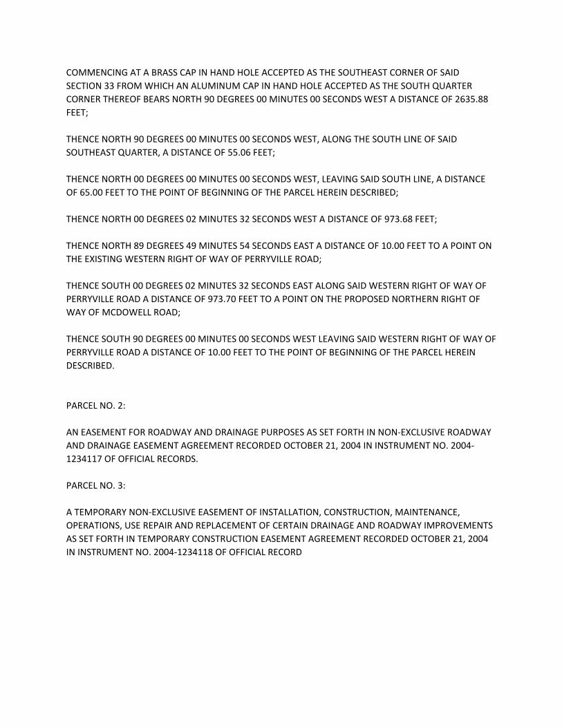
COMMENCING AT A BRASS CAP IN HAND HOLE ACCEPTED AS THE SOUTHEAST CORNER OF SAID SECTION 33 FROM WHICH AN ALUMINUM CAP IN HAND HOLE ACCEPTED AS THE SOUTH QUARTER CORNER THEREOF BEARS NORTH 90 DEGREES 00 MINUTES 00 SECONDS WEST A DISTANCE OF 2635.88 FEET; THENCE NORTH 90 DEGREES 00 MINUTES 00 SECONDS WEST, ALONG THE SOUTH LINE OF SAID SOUTHEAST QUARTER, A DISTANCE OF 55.06 FEET; THENCE NORTH 00 DEGREES 00 MINUTES 00 SECONDS WEST, LEAVING SAID SOUTH LINE, A DISTANCE OF 65.00 FEET TO THE POINT OF BEGINNING OF THE PARCEL HEREIN DESCRIBED; THENCE NORTH 00 DEGREES 02 MINUTES 32 SECONDS WEST A DISTANCE OF 973.68 FEET; THENCE NORTH 89 DEGREES 49 MINUTES 54 SECONDS EAST A DISTANCE OF 10.00 FEET TO A POINT ON THE EXISTING WESTERN RIGHT OF WAY OF PERRYVILLE ROAD; THENCE SOUTH 00 DEGREES 02 MINUTES 32 SECONDS EAST ALONG SAID WESTERN RIGHT OF WAY OF PERRYVILLE ROAD A DISTANCE OF 973.70 FEET TO A POINT ON THE PROPOSED NORTHERN RIGHT OF WAY OF MCDOWELL ROAD; THENCE SOUTH 90 DEGREES 00 MINUTES 00 SECONDS WEST LEAVING SAID WESTERN RIGHT OF WAY OF PERRYVILLE ROAD A DISTANCE OF 10.00 FEET TO THE POINT OF BEGINNING OF THE PARCEL HEREIN DESCRIBED. PARCEL NO. 2: AN EASEMENT FOR ROADWAY AND DRAINAGE PURPOSES AS SET FORTH IN NON-EXCLUSIVE ROADWAY AND DRAINAGE EASEMENT AGREEMENT RECORDED OCTOBER 21, 2004 IN INSTRUMENT NO. 2004-1234117 OF OFFICIAL RECORDS. PARCEL NO. 3: A TEMPORARY NON-EXCLUSIVE EASEMENT OF INSTALLATION, CONSTRUCTION, MAINTENANCE, OPERATIONS, USE REPAIR AND REPLACEMENT OF CERTAIN DRAINAGE AND ROADWAY IMPROVEMENTS AS SET FORTH IN TEMPORARY CONSTRUCTION EASEMENT AGREEMENT RECORDED OCTOBER 21, 2004 IN INSTRUMENT NO. 2004-1234118 OF OFFICIAL RECORD
INTERSTATEARIZONA
10
65 Ldn
70 LdnLEGEND
PROJECTBOUNDARY
PARCELBOUNDARY
RURAL
NEIGHBORHOOD
LUKE COMPATIBILITYAREA
BUSINESS ANDCOMMERCE
BUCKEYE/GOODYEARPLANNING AREA BOUNDARY
McDOWELL RDMcDOWELL RDMcDOWELL RDMcDOWELL RDMcDOWELL RDMcDOWELL RDMcDOWELL RDMcDOWELL RDMcDOWELL RDMcDOWELL RDMcDOWELL RDMcDOWELL RDMcDOWELL RDMcDOWELL RDMcDOWELL RDMcDOWELL RDMcDOWELL RD
PE
RR
YV
ILL
E R
DP
ER
RY
VIL
LE
RD
PE
RR
YV
ILL
E R
DP
ER
RY
VIL
LE
RD
PE
RR
YV
ILL
E R
DP
ER
RY
VIL
LE
RD
PE
RR
YV
ILL
E R
DP
ER
RY
VIL
LE
RD
PE
RR
YV
ILL
E R
DP
ER
RY
VIL
LE
RD
PE
RR
YV
ILL
E R
DP
ER
RY
VIL
LE
RD
PE
RR
YV
ILL
E R
DP
ER
RY
VIL
LE
RD
PE
RR
YV
ILL
E R
DP
ER
RY
VIL
LE
RD
PE
RR
YV
ILL
E R
DGP LAND USE:
RURAL
GP LAND USE:MILITARY
COMPATIBLE
EXISTING LAND USE:NEIGHBORHOOD
+/- 112 AC
EXISTINGLAND USE:
LUKECOMPATIBILITY
AREA
+/- 51 AC
NOT APART
CITY OFGOODYEAR
NORTH
This plan is conceptual and subject to change through the planning and development process.
PALOMA VISTABUCKEYE, AZ SCALE: 1"=600'
EXISTING GENERAL PLANLAND USE MAP
McDOWELL RDMcDOWELL RDMcDOWELL RDMcDOWELL RDMcDOWELL RDMcDOWELL RDMcDOWELL RDMcDOWELL RDMcDOWELL RDMcDOWELL RDMcDOWELL RDMcDOWELL RDMcDOWELL RDMcDOWELL RDMcDOWELL RDMcDOWELL RDMcDOWELL RD
INTERSTATEARIZONA
10
65 Ldn
70 LdnLEGEND
PROJECTBOUNDARY
PARCELBOUNDARY
RURAL
NEIGHBORHOOD
LUKE COMPATIBILITYAREA
BUSINESS ANDCOMMERCE
EMPLOYMENT
BUCKEYE/GOODYEARPLANNING AREA BOUNDARY
PE
RR
YV
ILL
E R
DP
ER
RY
VIL
LE
RD
PE
RR
YV
ILL
E R
DP
ER
RY
VIL
LE
RD
PE
RR
YV
ILL
E R
DP
ER
RY
VIL
LE
RD
PE
RR
YV
ILL
E R
DP
ER
RY
VIL
LE
RD
PE
RR
YV
ILL
E R
DP
ER
RY
VIL
LE
RD
PE
RR
YV
ILL
E R
DP
ER
RY
VIL
LE
RD
PE
RR
YV
ILL
E R
DP
ER
RY
VIL
LE
RD
PE
RR
YV
ILL
E R
DP
ER
RY
VIL
LE
RD
PE
RR
YV
ILL
E R
DGP LAND USE:
RURAL
CITY OFGOODYEAR
GP LAND USE:MILITARY
COMPATIBLE
PROPOSED LAND USE:EMPLOYMENT
+/- 112 AC
GP LAND USE:NEIGHBORHOOD
EXISTINGLAND USE:
LUKECOMPATIBILITY
AREA
+/- 51 AC
NOT APART
NORTH
This plan is conceptual and subject to change through the planning and development process.
PROPOSED GENERAL PLANLAND USE MAP
PALOMA VISTABUCKEYE, AZ SCALE: 1"=600'
PALOMA VISTAPALOMA VISTAPALOMA VISTAPALOMA VISTAPALOMA VISTAPALOMA VISTAPALOMA VISTAPALOMA VISTAPALOMA VISTAPALOMA VISTAPALOMA VISTAPALOMA VISTAPALOMA VISTAPALOMA VISTAPALOMA VISTAPALOMA VISTAPALOMA VISTA City of Goodyear
BP
NOT
A
PART
(BP)
BP
GC
CC
CC
CC
CC
CC
PR
PR
SF-43
RR
PR
IND-2
(MC)
RU-43
(MC)
RU-43
(MC)
AG
AG
NORTH
This plan is conceptual and subject to change through the planning and development process.
PALOMA VISTA
EXISTING ZONING MAP
BUCKEYE, AZ SCALE: 1"=800'DATE: MAY 2019
PALOMA VISTAPALOMA VISTAPALOMA VISTAPALOMA VISTAPALOMA VISTAPALOMA VISTAPALOMA VISTAPALOMA VISTAPALOMA VISTAPALOMA VISTAPALOMA VISTAPALOMA VISTAPALOMA VISTAPALOMA VISTAPALOMA VISTAPALOMA VISTAPALOMA VISTAI - 1 PAD
BP
NOT
A
PART
(BP)
BP
GC
CC
CC
CC
CC
CC
PR
SF-43
RR
PR
IND-2
(MC)
RU-43
(MC)
RU-43
(MC)
AG
AG
City of Goodyear
Per
ryvi
lle R
oad
McDowell Road
NORTH
This plan is conceptual and subject to change through the planning and development process.
PALOMA VISTA
PROPOSED ZONING MAP
BUCKEYE, AZ SCALE: 1"=800'DATE: JULY 2019
DRAFT
INTERSTATEARIZONA
10
65 Ldn
McDOWELL RDMcDOWELL RDMcDOWELL RDMcDOWELL RDMcDOWELL RDMcDOWELL RDMcDOWELL RDMcDOWELL RDMcDOWELL RDMcDOWELL RDMcDOWELL RDMcDOWELL RDMcDOWELL RDMcDOWELL RDMcDOWELL RDMcDOWELL RDMcDOWELL RD
PE
RR
YV
ILL
E R
DP
ER
RY
VIL
LE
RD
PE
RR
YV
ILL
E R
DP
ER
RY
VIL
LE
RD
PE
RR
YV
ILL
E R
DP
ER
RY
VIL
LE
RD
PE
RR
YV
ILL
E R
DP
ER
RY
VIL
LE
RD
PE
RR
YV
ILL
E R
DP
ER
RY
VIL
LE
RD
PE
RR
YV
ILL
E R
DP
ER
RY
VIL
LE
RD
PE
RR
YV
ILL
E R
DP
ER
RY
VIL
LE
RD
PE
RR
YV
ILL
E R
DP
ER
RY
VIL
LE
RD
PE
RR
YV
ILL
E R
D
THOMAS RDTHOMAS RDTHOMAS RDTHOMAS RDTHOMAS RDTHOMAS RDTHOMAS RDTHOMAS RDTHOMAS RDTHOMAS RDTHOMAS RDTHOMAS RDTHOMAS RDTHOMAS RDTHOMAS RDTHOMAS RDTHOMAS RD
NORTH
This plan is conceptual and subject to change through the planning and development process.
PALOMA VISTA
CONCEPTUAL TRAIL LOCATION
BUCKEYE, AZ SCALE: 1"=900'DATE: AUGUST 2019
LEGENDPROJECT BOUNDARY
REGIONAL TRAIL
FEMA FLOODPLAINZONE AE