Embed Size (px)
Citation preview
Analyzing Urban Geography
Parts taken from the 2012 AP Princeton Review Human Geography
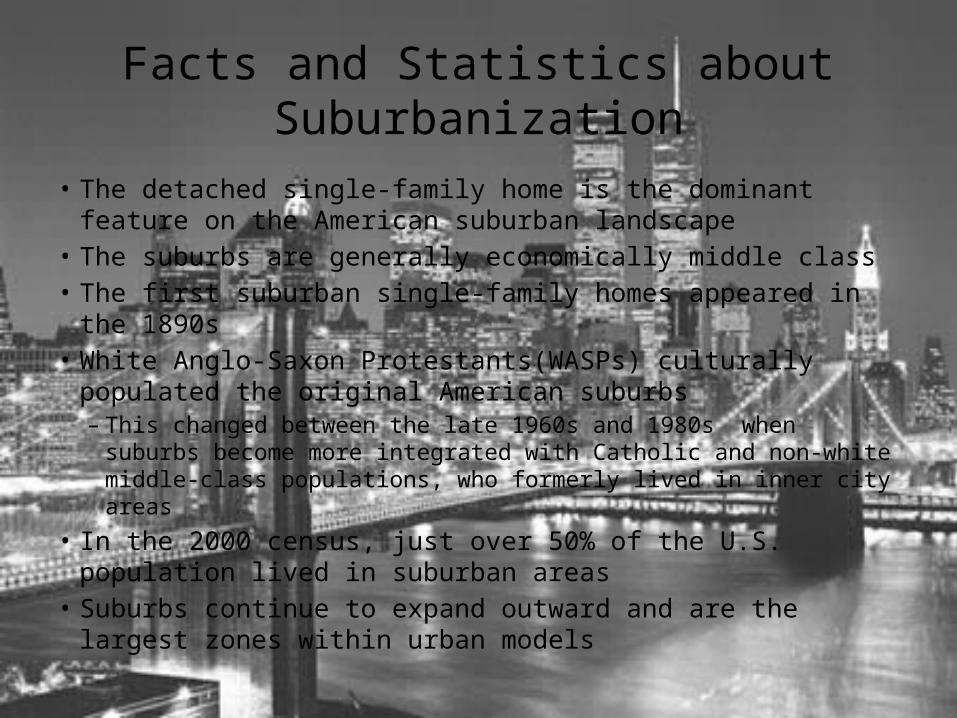
Facts and Statistics about Suburbanization
• The detached single-family home is the dominant feature on the American suburban landscape
• The suburbs are generally economically middle class• The first suburban single-family homes appeared in the 1890s• White Anglo-Saxon Protestants(WASPs) culturally populated the
original American suburbs– This changed between the late 1960s and 1980s when suburbs
become more integrated with Catholic and non-white middle-class populations, who formerly lived in inner city areas
• In the 2000 census, just over 50% of the U.S. population lived in suburban areas
• Suburbs continue to expand outward and are the largest zones within urban models
Home Mortgage Finance and Suburban Growth
• In post-World War II United States, homeownership increased significantly as a result of federal home loan programs such as the G.I. Bill– Other federal programs such as the Federal Housing Administration and the
public finance mortgage corporations Freddie Mac and Fannie Mae have increased the number of mortgages available to the American public with regulated interest rates and limited processing fees
– Resulted in a massive influx in new home construction during the 1950s and ’60s
• High demand led to factory-style housing construction methods becoming common– The use of prefabricated parts and specialized construction teams
• The Levitt Company built large communities of single-family homes– Could be constructed from start to finish in less than 18 days
Service Relocation in the Suburbs• The increase in suburban home construction prompted a number
of small services providers to be located in suburban areas– Services provided included basic services and non-basic services
• Examples of basic services are food, doctor, fuel, and auto repair– “Needs”
• Examples of non-basic services are dry cleaning and gift shops– “Wants”
• In the 1970s, the combination of middle-class flight from the inner city and deindustrialization of urban manufacturing economies prompted more and larger service providers to relocate to suburban areas– Companies brought their services to where suburban consumers lived– Companies brought their service industry jobs to where the white-collar
workers lived
Suburban Sprawl• The expansion of housing, transportation, and commercial development to undeveloped
land on the urban periphery• Sustainability within the suburban context can be measured in both economic and
environmental terms• Cited as the cause of numerous problems including traffic congestion, lack of public
school funding, environmental degradation, and economic decline in farming• Suburban political anti-growth movements have emerged in the United States and
Canada– Push for new laws and regulations that delay suburban development and limit approval of new
suburban roads and highways– Especially strong in places where the surrounding rural areas are environmentally sensitive or
have historical significance• Increased congestion in suburbs from suburban commercial development and sprawl has
compelled some suburban residents to move further away from the city• Counterurbanization
– Suburban residents move to rural areas to escape the congestion, crime, pollution, and other negative aspects of the urban landscape

Edge Cities• Concept was originated by Joel Garreau in 1991
– He noticed that some suburban CBDs had grown to immense size and economic prominence
• Characteristics of an edge city– Minimum of 5 million square feet of office space– Minimum 600,000 square feet of retail space– No city government, except where built atop an existing town– High daytime population, low nighttime population– Located at transportation nodes or along commuter corridors
• An effect of edge city growth– An increase in lateral commuting between suburbs and edge cities – Significant amounts of counter-commuting have been detected from downtown
residents to edge city locations• Large amounts of lateral commuting and counter-commuting have made it
necessary to construct transportation plans that have multiple hub-and-spoke traffic flow patterns centered on edge city locations in addition to the old CBD
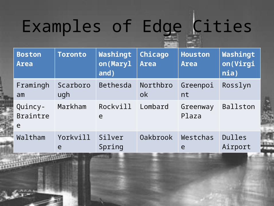
Examples of Edge CitiesBoston Area Toronto Washington
(Maryland)Chicago Area
Houston Area
Washington(Virginia)
Framingham Scarborough Bethesda Northbrook Greenpoint Rosslyn
Quincy-Braintree
Markham Rockville Lombard Greenway Plaza
Ballston
Waltham Yorkville Silver Spring Oakbrook Westchase Dulles Airport
Colonial City
• Cities with origins as centers of colonial trade or administration– Many retain their European-style buildings and street networks
• Newly independent governments have often changed street names and place-names to reflect local culture and social history– India has renamed the major cities of Mumbai, Chennai, and
Kolkata from their British colonial names of Bombay, Madras, and Calcutta
– Others countries have moved their national capitals away from former colonial capitals
Fall-Line Cities• Larger colonial-era cities in the U.S. were most often port locations
– Fall-line city is used to describe the ports that lay upstream on coastal rivers at a point where navigation was no longer possible by ocean-going ships
– Break-in-bulk points were where ships were offloaded and then packed with exports
• Many fall-line cities became both centers of trade and manufacturing in the 1800s
• Industrial Fall-Line Cities in the United States– Boston– Providence– Albany– Philadelphia– Baltimore

Medieval Cities
• Urban centers that predate the European Renaissance– In Europe• Paris, Rome, London, Cologne, Marseille, York…
– Outside of Europe• Istanbul, Samarkand, Kyoto, Beijing…
Gateway Cities
• Places where immigrants make their way into a country– Tend to have high immigrant populations
Entrepot
• A port city in which goods are shipped at one price and shipped out to other port locations at a higher price– Profitable trade
• This trade is made possible by the lack of custom duties– Import and export taxes
• Tend to become large centers of finance, warehousing, and the global shipping trade

Megacity
• A metropolitan area with more than 10 million people
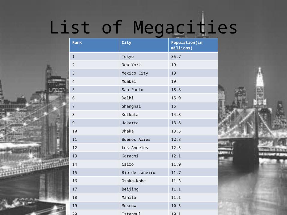
List of MegacitiesRank City Population(in millions)
1 Tokyo 35.7
2 New York 19
3 Mexico City 19
4 Mumbai 19
5 Sao Paulo 18.8
6 Delhi 15.9
7 Shanghai 15
8 Kolkata 14.8
9 Jakarta 13.8
10 Dhaka 13.5
11 Buenos Aires 12.8
12 Los Angeles 12.5
13 Karachi 12.1
14 Cairo 11.9
15 Rio de Janeiro 11.7
16 Osaka-Kobe 11.3
17 Beijing 11.1
18 Manila 11.1
19 Moscow 10.5
20 Istanbul 10.1
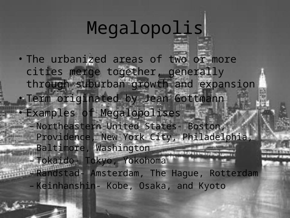
Megalopolis
• The urbanized areas of two or more cities merge together, generally through suburban growth and expansion
• Term originated by Jean Gottmann• Examples of Megalopolises– Northeastern United States- Boston, Providence, New
York City, Philadelphia, Baltimore, Washington– Tokaido- Tokyo, Yokohoma– Randstad- Amsterdam, The Hague, Rotterdam– Keinhanshin- Kobe, Osaka, and Kyoto
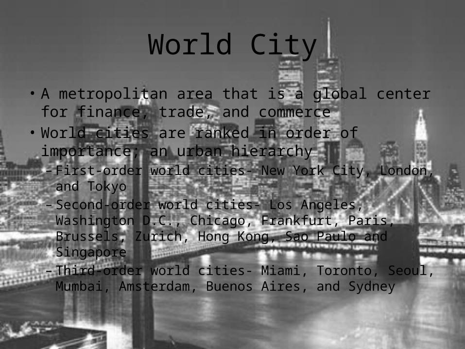
World City
• A metropolitan area that is a global center for finance, trade, and commerce
• World cities are ranked in order of importance; an urban hierarchy– First-order world cities- New York City, London, and Tokyo– Second-order world cities- Los Angeles, Washington D.C.,
Chicago, Frankfurt, Paris, Brussels, Zurich, Hong Kong, Sao Paulo and Singapore
– Third-order world cities- Miami, Toronto, Seoul, Mumbai, Amsterdam, Buenos Aires, and Sydney
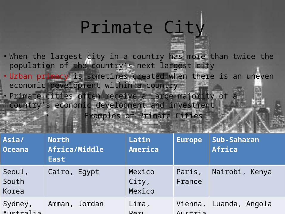
Primate City• When the largest city in a country has more than twice the population of the
country’s next largest city• Urban primacy is sometimes created when there is an uneven economic
development within a country• Primate cities often receive a large majority of a country’s economic development
and investment• Examples of Primate Cities:
Asia/Oceana North Africa/Middle East Latin America Europe Sub-Saharan Africa
Seoul, South Korea
Cairo, Egypt Mexico City, Mexico
Paris, France
Nairobi, Kenya
Sydney, Australia
Amman, Jordan Lima, Peru Vienna, Austria
Luanda, Angola
The Rank-Size Rule
• Theoretical• An urban hierarchy of city population• States that a country’s second largest city is half the
population of the largest city, third largest, a third, and etc…
• Formula– The nth largest city is 1/n the size of the country’s largest
city• Few countries follow the Rank-Size rule, however
the United States and Russia closely match
Segregation• Ethnic neighborhoods are occasionally areas of de facto segregation where no law
requiring ethnic or racial segregation exists, yet they nonetheless are zones of separation– Legal segregation(de jure segregation) existed in the United States
• Jim Crow laws
• Today, Chinatowns are seen as cultural districts, but many have their origins as zones where Chinese, Filipino, and Japanese migrants were forced to live
• Banks and insurance providers historically engaged in redlining– Designating neighborhoods on company maps where house mortgage and insurance applications
would be automatically denied– The Federal Housing Administration now enforces rules against redlining
• Restrictive covenants where when homeowners added special covenants to their home and real estate titles, restricting future sales of a home to white-only buyers– Some covenants have also attempted to restrict Jews from buying
• Even following the Civil Rights Act of 1964, some white urban communities openly engaged in racial steering, mainly through the use of real estate agents– When non-whites attempted to buy homes, real estate companies or their agents directed them to
racially specific neighborhoods, regardless of income– Banned in the Fair Housing Act in 1968
Women and the City• The percentage of female-headed households in urban areas has
increased significantly in recent decades– Studies show that female heads of household are likely to depend on
public transportation and must live near bus and subway stations– Female heads of household must access food shopping, health care, and
other services and plan their home location accordingly• The role of women in the United States and Canada has changed
significantly in past decades– Women are becoming increasingly equal to men in wages, access to higher
job positions, and political power– Two sectors of the service economy, health care and education, have seen
women surpass men in terms of the number of positions and average pay• Medical schools in the United States reported in 2008 that entering classes were
50% female for the first time
Gentrification• The economic reinvestment in existing real estate• Began in the 1970s when people in the historical preservation
movement began renovating homes in places such as Greenwich Village in New York City and Georgetown in D.C.– Consumer demand for gentrified homes with modern amenities increased– By the 1990s, a whole cottage industry in gentrification had emerged where
people would buy old homes at low prices, renovated the homes, and then resold them for profit
• Commercial gentrification– Formerly closed business places were rebuilt as coffee shops, art houses, bars,
and restaurants– Mixed use development was also common
• Neighborhood gentrification has a negative effect of driving out low-income residents from the community– As the price of gentrified homes increase, the price of non-gentrified real estate
increases as well
Silicon Valley: Economic Growth• Companies usually place their offices near growth poles for their
industry– Economic multiplier effects around these poles result in a multitude of
companies and investment in computer hardware and software development
• As rare commodities, standard three-bedroom homes in Palo Alto can cost upwards of $900,000– A one-bedroom apartment can rent for over $2000 a month
• Affordable housing for Silicon Valley residents who are not engaged in the technology economy has became a major urban social issue– This is true for other cities in the United States where high pay and
limited housing have created inflated real estate prices
The Expense of Schools
• Property taxes on homes often do not meet the cost and demand for high-quality schools– School systems are caught between a public that
does not want to pay higher taxes and parents that demand higher-quality schooling for their children• Local school districts are increasingly dependent on
state governments to help meet funding needs or are forced to cut extracurricular activities and increase class size
Environmental Sustainability
• Issues that concern urban governments– Local air pollution– Wetlands loss– Watershed management– Parkland creation– Waste management– Global warming

Urban Transportation
• Traffic congestion– Smog from vehicles is harmful to public health and
can create a haze– Carbon dioxide emissions from cars are a significant
source of greenhouse gases that contribute to the problem of global warming
• The benefits of mass transit have become important to most cities– Fewer cars on the highway, reduced emissions,
increased accessibility for low income citizens, etc…
New Downtown Housing
• Mixed-use buildings have became popular– Contain both housing and commercial space– Referred to as “New Urbanism”
• Effect of New Urbanism– Has forced cities to re-examine the sustainability of their zoning
codes– Many cities have added new zoning categories that allow for mixed-
use development and special planning districts where housing, public transit, and office space is more spatially integrated
• Criticism of mixed-use downtown housing– The purchase of these new units are so high that only the upper
middle-class income earners can afford to live there– To combat this, some cities require a certain percentage of new
construction to be priced specifically for lower to middle income buyers
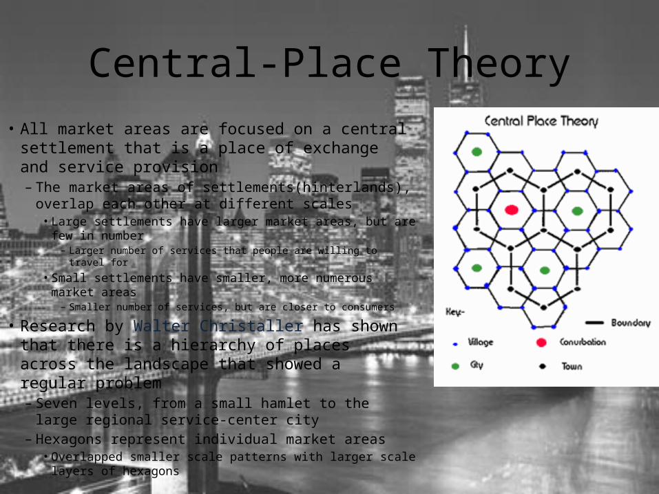
Central-Place Theory• All market areas are focused on a central
settlement that is a place of exchange and service provision– The market areas of settlements(hinterlands), overlap
each other at different scales• Large settlements have larger market areas, but are few in
number– Larger number of services that people are willing to travel for
• Small settlements have smaller, more numerous market areas– Smaller number of services, but are closer to consumers
• Research by Walter Christaller has shown that there is a hierarchy of places across the landscape that showed a regular problem– Seven levels, from a small hamlet to the large regional
service-center city– Hexagons represent individual market areas
• Overlapped smaller scale patterns with larger scale layers of hexagons
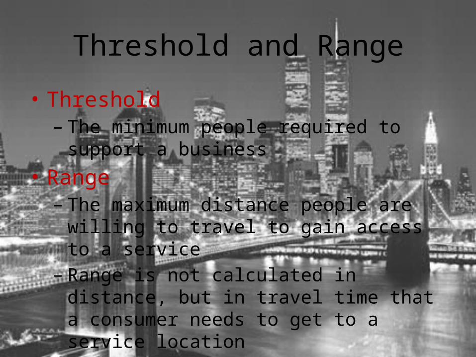
Threshold and Range
• Threshold– The minimum people required to support a
business• Range– The maximum distance people are willing to travel
to gain access to a service– Range is not calculated in distance, but in travel
time that a consumer needs to get to a service location
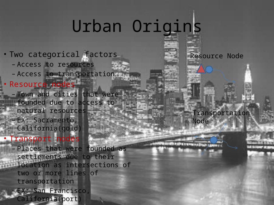
Urban Origins
• Two categorical factors– Access to resources– Access to transportation
• Resource nodes– Town and cities that were
founded due to access to natural resources
– EX: Sacramento, California(gold)• Transport nodes
– Places that were founded as settlements due to their location as intersections of two or more lines of transportation
– EX: San Francisco, California(port)
Resource Node
Transportation Node
Settlement Patterns• Clustered rural settlements
– Communities in which all of the residential and farm structures of multiple households are arranged closely together
– Commonly seen in Europe and New England• People settled near each other for social interaction, use of common land-holdings, and
security
– Can have circular or linear settlements• Circular settlements are generally a circle of homes surrounding a central open space
– EX: Medieval-German and English towns, Sub-Saharan Africa
• Linear settlements usually follow along a road or a stream front– EX: French long lots
• Dispersed rural settlements– Households are separated from one another by significant distances– Commonly seen in farm regions of the American South, Midwest, and Great
Plains• Families often had no cultural or family relations on the agricultural frontier, so people
lived further apart
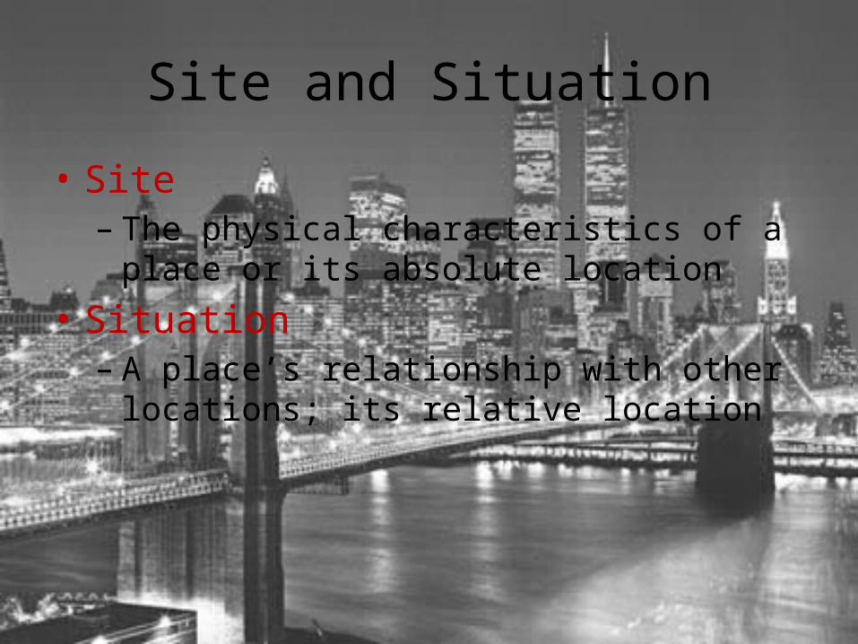
Site and Situation
• Site– The physical characteristics of a place or its
absolute location• Situation– A place’s relationship with other locations; its
relative location
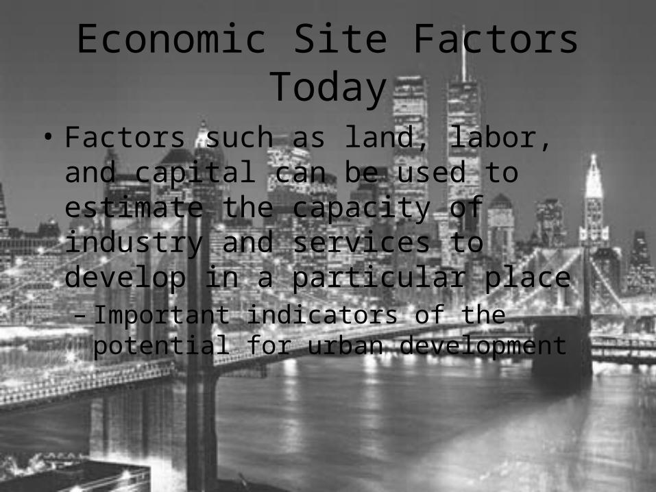
Economic Site Factors Today
• Factors such as land, labor, and capital can be used to estimate the capacity of industry and services to develop in a particular place– Important indicators of the potential for urban
development
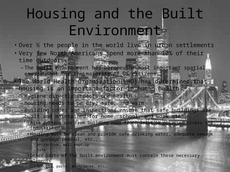
Housing and the Built Environment• Over ½ the people in the world live in urban settlements• Very few North Americans spend more than 10% of their time outdoors
– The built environment has become the most important spatial environment for the majority of US citizens
• The World Health Organization(WHO) has determined that housing is an important factor in human health– Hygiene directly impacts one health– Housing needs to be dry, safe, and warm– Building codes and inspections ensure that safe buildings are built and
maintained for home, school, and work use• Also protect use from building near floodplains or polluted rivers and industries• Housing must be clean and provide safe drinking water, adequate sewage and garbage
removal, etc..– Attractive, well kept-up– Safe
• Other parts of the built environment must contain these necessary elements– Schools, parks, workplaces, etc…
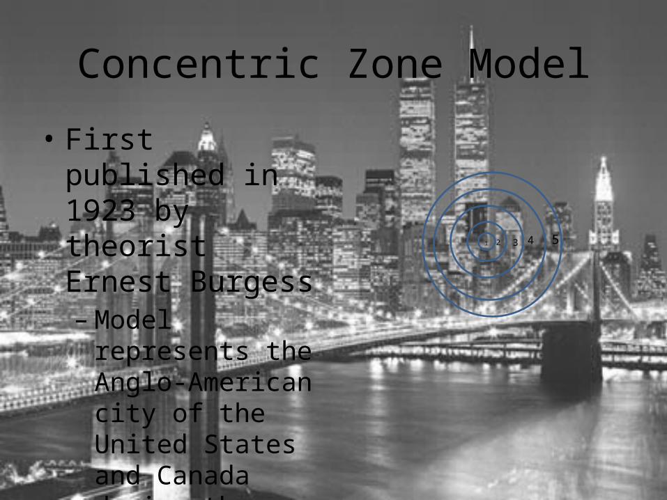
Concentric Zone Model
• First published in 1923 by theorist Ernest Burgess– Model represents the
Anglo-American city of the United States and Canada during the height of industrialization
1 2 3 4 5
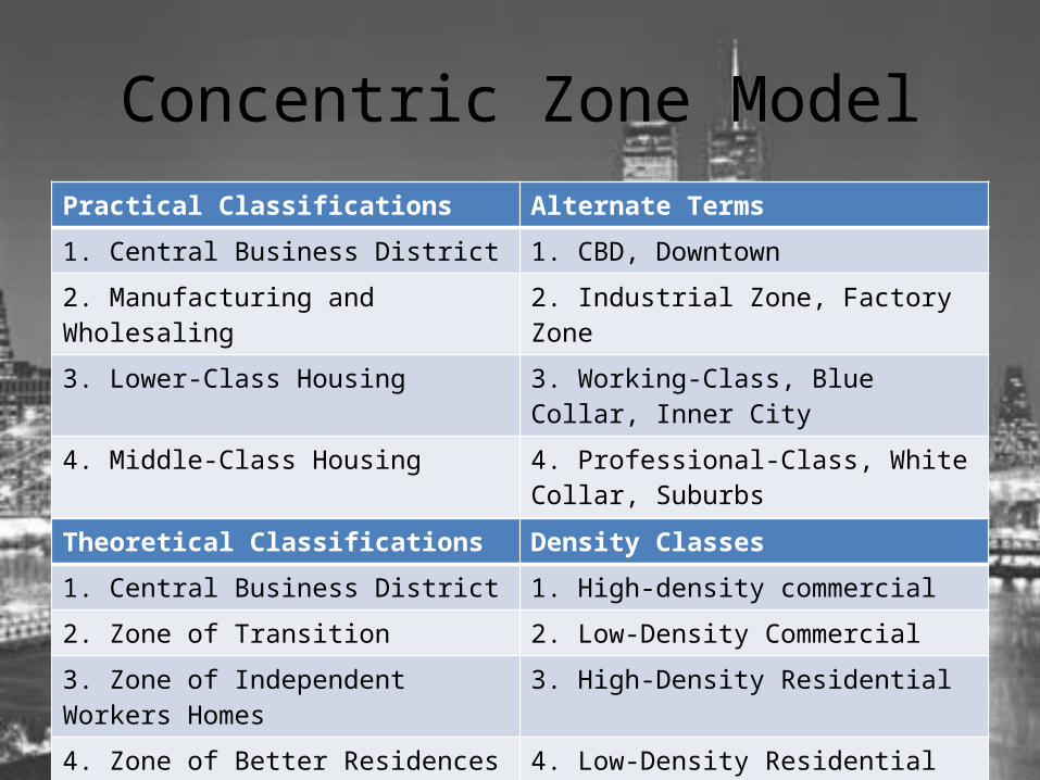
Concentric Zone ModelPractical Classifications Alternate Terms
1. Central Business District 1. CBD, Downtown
2. Manufacturing and Wholesaling 2. Industrial Zone, Factory Zone
3. Lower-Class Housing 3. Working-Class, Blue Collar, Inner City
4. Middle-Class Housing 4. Professional-Class, White Collar, Suburbs
5. Upper-Class Housing 5. Country Estates, Exurbs
Theoretical Classifications Density Classes
1. Central Business District 1. High-density commercial
2. Zone of Transition 2. Low-Density Commercial
3. Zone of Independent Workers Homes 3. High-Density Residential
4. Zone of Better Residences 4. Low-Density Residential
5. Commuter Zone 5. Very Low-Density Residential
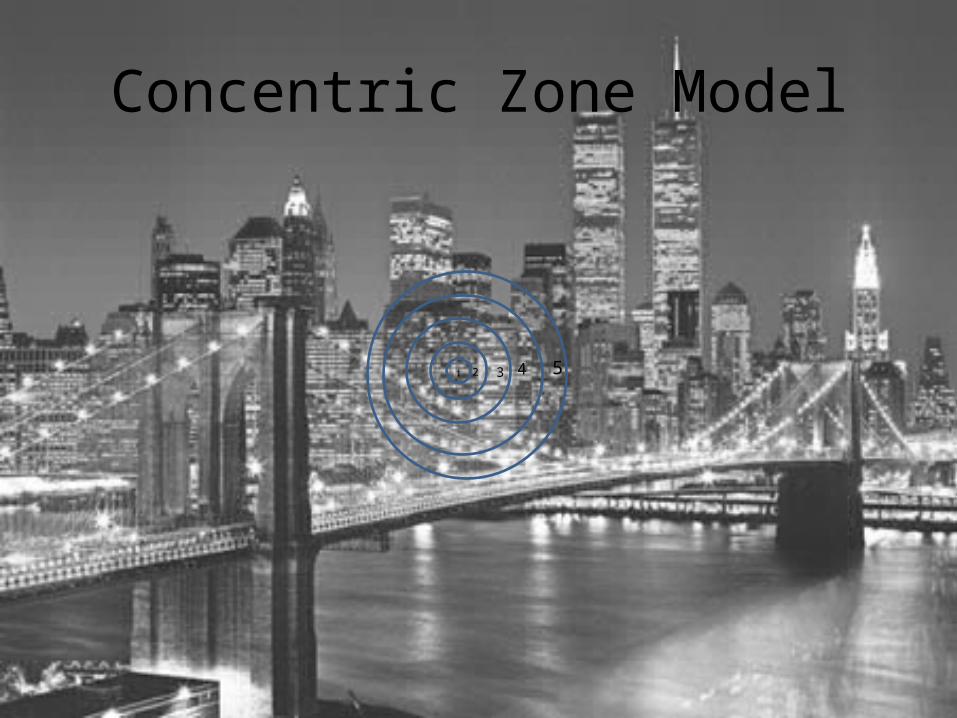
Concentric Zone Model
1 2 3 4 5
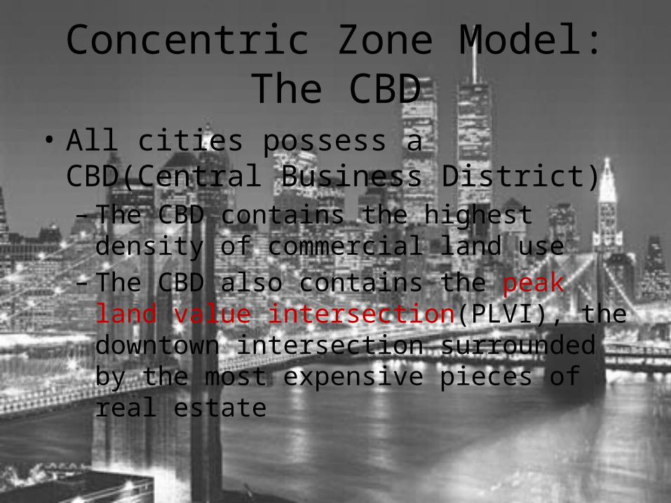
Concentric Zone Model: The CBD
• All cities possess a CBD(Central Business District)– The CBD contains the highest density of
commercial land use– The CBD also contains the peak land value
intersection(PLVI), the downtown intersection surrounded by the most expensive pieces of real estate

Concentric Zone Model: Industrial Zone
• The CBD is surrounded by an area of low-density commercial land that contains space-dependent activities such as factories, warehouses, rail yards and port facilities– Many American and Canadian cities have rebuilt
former industrial areas into festival landscapes, converting the spaces and buildings into parks, museums, stadiums, arenas, etc…
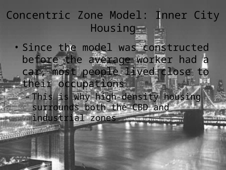
Concentric Zone Model: Inner City Housing
• Since the model was constructed before the average worker had a car, most people lived close to their occupations– This is why high-density housing surrounds both
the CBD and industrial zones

Concentric Zone Model: The Suburbs
• In the 1870s, the first planned developments with detached single-family homes began to appear on the periphery of American cities– EX: Riverside, Illinois
• The detached single family home has became the most common housing structure– Suburbs continued to grow through the 1920s, but
expansion ceased during the Great Depression and World War II
• Suburbs are home to a mostly middle-class to upper-class population
Concentric Zone Model: The Exurbs
• Represents a wealthy area of people who own large tracts of land outside the city– Some can be described as country estates and others
might be better described as suitcase farmers• Suitcase farmers were able to afford large homes and were able
to afford a personal vehicle or daily train ticket
• Many suburban and exurban areas in large cities have pushed well into traditional agricultural areas– Prompted the development of regulations, including
farmland protection laws, minimum-acreage zoning, and development boundary zones
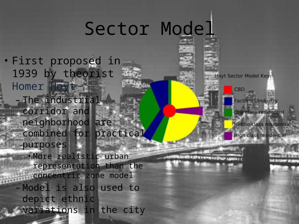
Sector Model
• First proposed in 1939 by theorist Homer Hoyt– The industrial corridor
and neighborhood are combined for practical purposes• More realistic urban
representation than the concentric zone model
– Model is also used to depict ethnic variations in the city
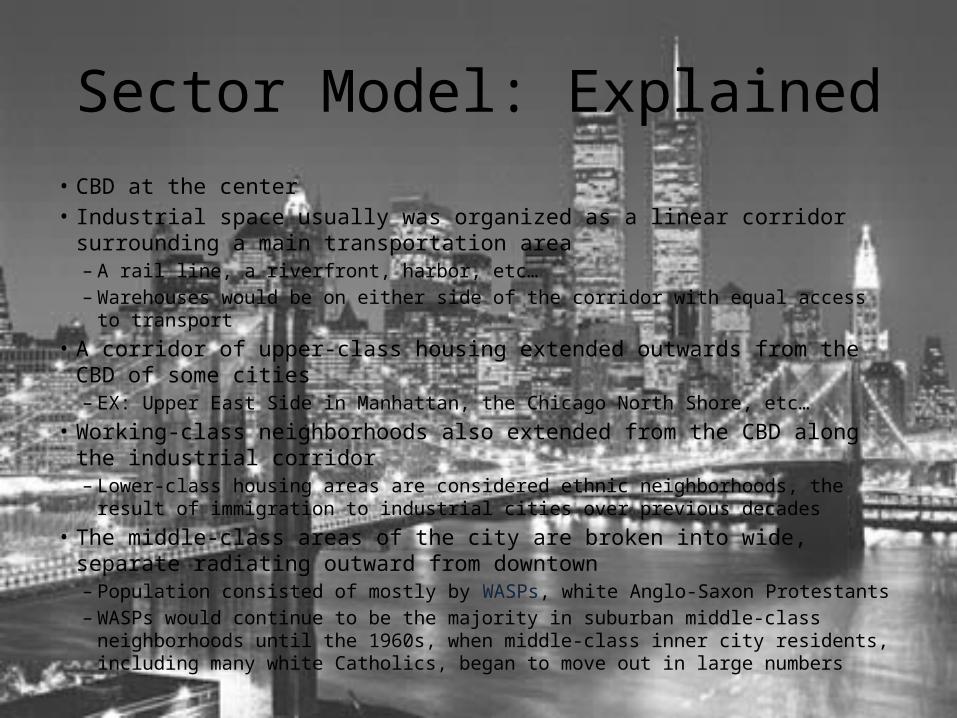
Sector Model: Explained• CBD at the center• Industrial space usually was organized as a linear corridor surrounding a main
transportation area– A rail line, a riverfront, harbor, etc…– Warehouses would be on either side of the corridor with equal access to transport
• A corridor of upper-class housing extended outwards from the CBD of some cities– EX: Upper East Side in Manhattan, the Chicago North Shore, etc…
• Working-class neighborhoods also extended from the CBD along the industrial corridor– Lower-class housing areas are considered ethnic neighborhoods, the result of
immigration to industrial cities over previous decades• The middle-class areas of the city are broken into wide, separate radiating
outward from downtown– Population consisted of mostly by WASPs, white Anglo-Saxon Protestants– WASPs would continue to be the majority in suburban middle-class neighborhoods until
the 1960s, when middle-class inner city residents, including many white Catholics, began to move out in large numbers
White Flight
• Many social scientists have described the phenomenon of people leaving inner city areas of the United States as “white flight”– Regardless of race, many inner-city residents with
middle-class incomes moved out to suburban districts to escape the social unrest and economic difficulties of deindustrialization that characterized the 1960s and ‘70s in the United States
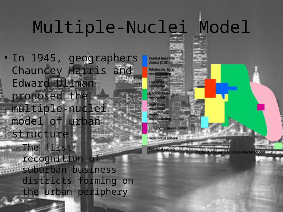
Multiple-Nuclei Model
• In 1945, geographers Chauncey Harris and Edward Ullman proposed the multiple-nuclei model of urban structure– The first recognition of
suburban business districts forming on the urban periphery
Multiple-Nuclei Model: Explained
• Attempts to represent the urban landscape with neighborhoods and commercial corridors– Multiple-nuclei implies that there is more than one commercial
center within the urban landscape• New suburban CBDs were emerging in post-World War II cities,
and as suburbs spread outward, service industries followed– Service providers came to the suburbs to be closer to their
consumers and stay near members of the service workforce• New industrial development was also located on the urban
periphery– New areas were added for manufacturing war technologies and
other products

The “Death of the American Downtown” in the 1970s
• Deindustrialization– Old factories and related industries and services were shut down
• Labor force moved away and capital investment into downtown real estate dwindled
• Having lost many consumers, the CBD was no longer the most prominent place in the urban economy
– Moving away from a manufacturing-based economy to a service-based economy• As services migrated to the suburbs, money to invest in commercial real estate
moved as well
– Developers continued their focus on suburban expansion and suburban CBD development until the mid-1990s when a renewed focus on downtowns received business and government attention• Property prices had dropped significantly through the 1980s and early 1990s, and
cost effective opportunities to reinvest in downtown real estate began to emerge
Galactic City Model or Periphery Model• Many of the new suburban CBDs in the United States and Canada have become specialized
toward a particular industrial or service sector– Represents the post-industrial city with its several, dispersed business districts
• Represents a distinct decentralization of the commercial urban landscape as the economy has transitioned to services as the leading form of production– Manufacturing has declined significantly and become specialized
• New manufacturing facilities tend to be much smaller and require low-cost land to afford to operate• Often subsidized by local governments to lower costs and increase employment opportunities
• Transportation nodes are common locations for suburban CBDs due to their high level of access
• Service specializations found in CBDs– High-technology and computing– Research and Development– Transportation services– Bio-technology– Hospitals– Telecommunications– Banking and finance– Universities
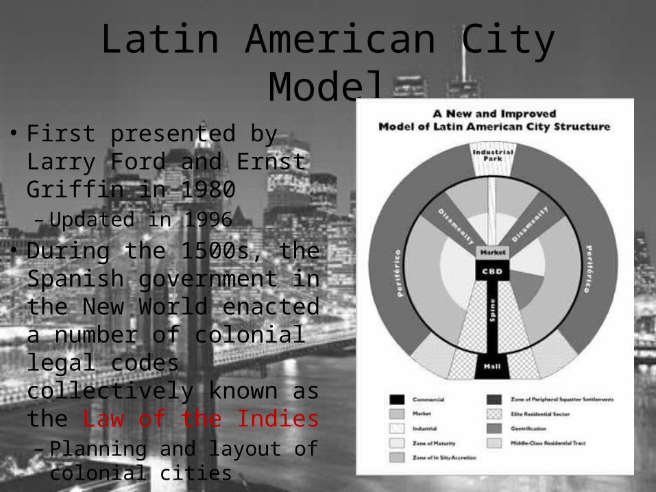
Latin American City Model
• First presented by Larry Ford and Ernst Griffin in 1980– Updated in 1996
• During the 1500s, the Spanish government in the New World enacted a number of colonial legal codes collectively known as the Law of the Indies – Planning and layout of
colonial cities
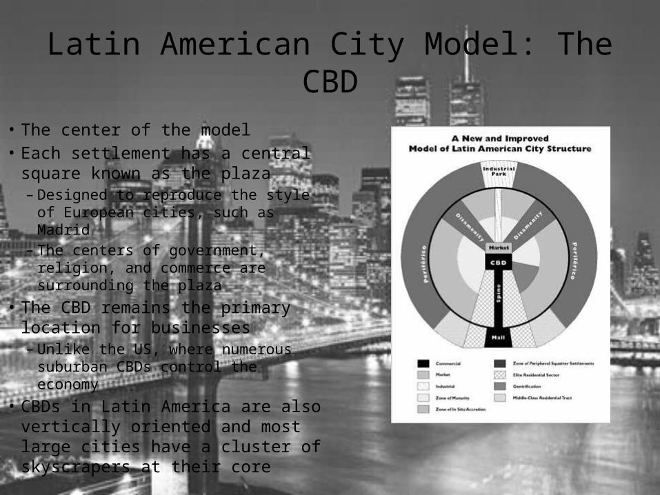
Latin American City Model: The CBD
• The center of the model• Each settlement has a central square
known as the plaza– Designed to reproduce the style of
European cities, such as Madrid– The centers of government, religion,
and commerce are surrounding the plaza
• The CBD remains the primary location for businesses– Unlike the US, where numerous
suburban CBDs control the economy• CBDs in Latin America are also
vertically oriented and most large cities have a cluster of skyscrapers at their core
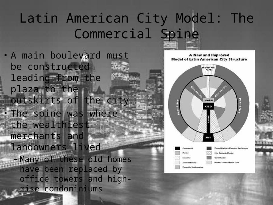
Latin American City Model: The Commercial Spine
• A main boulevard must be constructed leading from the plaza to the outskirts of the city
• The spine was where the wealthiest merchants and landowners lived– Many of these old homes
have been replaced by office towers and high-rise condominiums
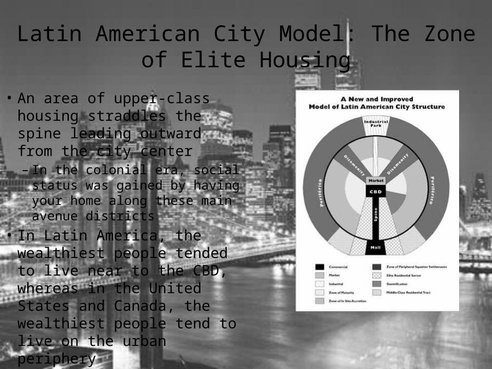
Latin American City Model: The Zone of Elite Housing
• An area of upper-class housing straddles the spine leading outward from the city center– In the colonial era, social status
was gained by having your home along these main avenue districts
• In Latin America, the wealthiest people tended to live near to the CBD, whereas in the United States and Canada, the wealthiest people tend to live on the urban periphery
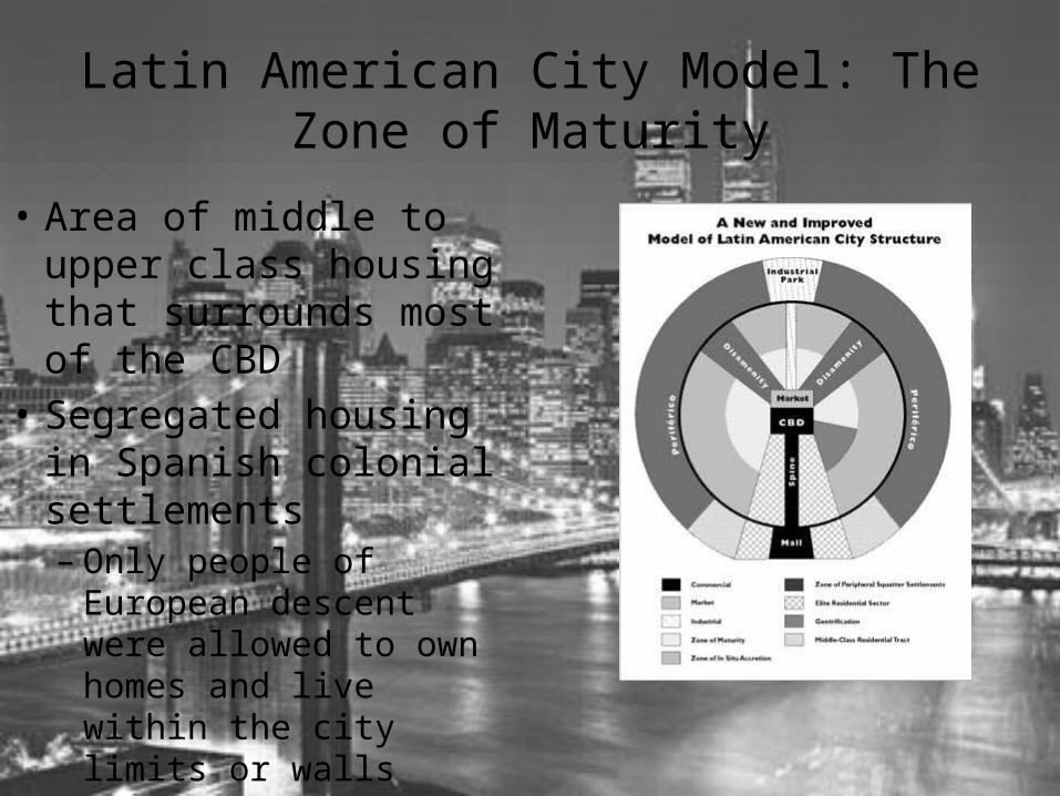
Latin American City Model: The Zone of Maturity
• Area of middle to upper class housing that surrounds most of the CBD
• Segregated housing in Spanish colonial settlements– Only people of European
descent were allowed to own homes and live within the city limits or walls
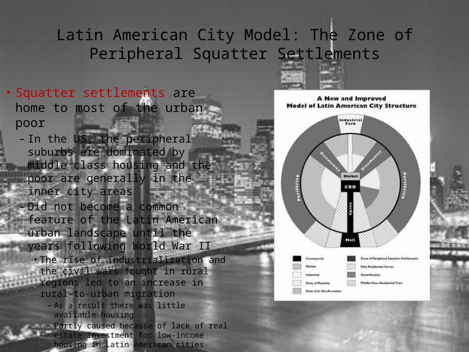
Latin American City Model: The Zone of Peripheral Squatter Settlements
• Squatter settlements are home to most of the urban poor– In the US, the peripheral suburbs
are dominated by middle class housing and the poor are generally in the inner city areas
– Did not become a common feature of the Latin American urban landscape until the years following World War II• The rise of industrialization and the
civil wars fought in rural regions led to an increase in rural-to-urban migration– As a result there was little available
housing– Partly caused because of lack of real
estate investment for low-income housing in Latin American cities
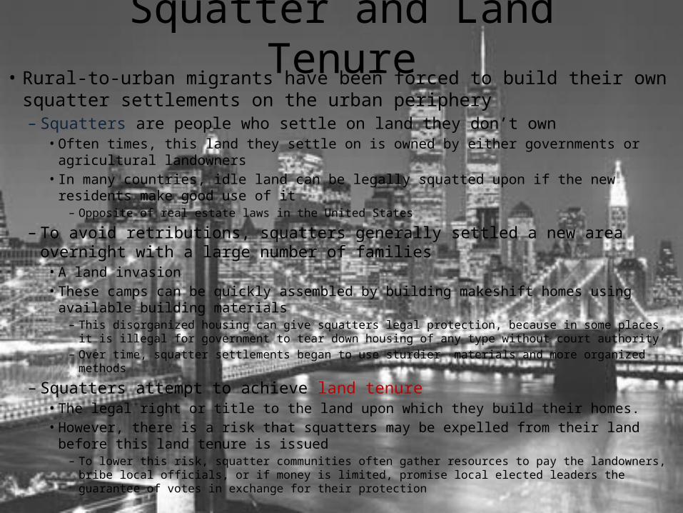
Squatter and Land Tenure• Rural-to-urban migrants have been forced to build their own squatter
settlements on the urban periphery– Squatters are people who settle on land they don’t own
• Often times, this land they settle on is owned by either governments or agricultural landowners
• In many countries, idle land can be legally squatted upon if the new residents make good use of it– Opposite of real estate laws in the United States
– To avoid retributions, squatters generally settled a new area overnight with a large number of families• A land invasion• These camps can be quickly assembled by building makeshift homes using available building
materials– This disorganized housing can give squatters legal protection, because in some places, it is illegal for
government to tear down housing of any type without court authority– Over time, squatter settlements began to use sturdier materials and more organized methods
– Squatters attempt to achieve land tenure• The legal right or title to the land upon which they build their homes.• However, there is a risk that squatters may be expelled from their land before this land tenure
is issued– To lower this risk, squatter communities often gather resources to pay the landowners, bribe local officials,
or if money is limited, promise local elected leaders the guarantee of votes in exchange for their protection

Zones of Disamenity
• Squatter communities that are closer to the city– Built on land that is deemed unsuitable for
standard homes and businesses– Settled because of their availability and close
proximity to work opportunities in the city center• Often unstable– A mudslide, flood, or fire, would severely
endanger these settlements
The Updated Model
• In the Zone of Maturity, CBD expansion and growth of high-rise apartments has caused city residents to be concerned that much of the old city character is being lost– Numerous cities have promoted the gentrification of the colonial
era homes and neighborhoods that remain• These neighborhoods have high tourism value and protect the local
culture
• The Zone of Peripheral Squatter Settlements is expanded to reflect the rural-to-urban migration– Three features have been added to the model
• Shopping malls• Belt highways• Industrial park zone
International Urban Diversity• Cities around the world have very different urban forms and structure
– Cities in Western Europe are much more compact than U.S. cities• They were developed for pedestrians and are smaller in area to allow pedestrians to walk from location to location• Public transportation is well developed
– In Eastern Europe and countries of the former Soviet Union there is a strict division between urban and rural zones and the overwhelming majority of residents live in apartments• The central part of the city was not used for retail or commercial purposes, but for government activities and recreational
parks• Microdistricts provide workers with housing near the job sites
• Cities in the developing world have widely divergent forms determined mostly by their religious make-up, colonial history, socialist influences, and other cultural and social influences– Some cities were established as colonial administration centers
• Mumbai and Kolkata• Dakar
– Some cities were built to serve as growth poles and were planned to attract people and industry to that region of the country• Brasilia
• All developing world cities have– A large modern center of commerce– A massive immigrant population from rural regions– Rapidly growing rates of natural increase– Huge outer rings of squatter settlements