Embed Size (px)
Citation preview

Analysis on regional structure and spatial characteristics of oasis urban
agglomerations
ZHANG Yu-fang YANG De-gang
Xinjiang Institute of Ecology and Geography
Chinese Academy of Sciences

Outline
• Study background and meaning
• Material and methodology
• Objectives
• Results and analysis
• Conclusions and suggestion

Study background and meaningOptimization of geographic spatial structure is a main content of studying urban sustainable development.
The study just focus on the inside structure of single city or urban agglomerations in developed region.
The urban agglomerations on the northern slope of the Tianshan Mountains is a central area of Xinjiang and plays a decisive role in social and economic development of the region .
The economic development is fast and promising.
Understanding of the spatial structure of oasis urban agglomerations is very necessary and meaningful for promoting the development of this area.

Study background and meaning
Eight cities: Urumqi, Miquan, Fukang, Changji, Shihezi, Kuytun, Karamay, Usu

Material
•The data of the urban work force and population from
Urban Statistical Yearbook of China from 1991~2001
Statistical yearbook of Xinjiang from 1991, 2001, 2006
•Commuting distance between cities
•Digital elevation map and Landsat ETM images(2000) of the
northern slope of the Tianshan Mountains
Material and methodology

Methodology
•Fractal theory A branch of nonlinear science and an important means for science research. An effective methodology on studying the urban systems of the city geography. To reveal the geographic spatial structures.
Zipf dimension Space relation fractal dimension
•The method to classify city function Using data of the urban work force structure, statistical analysis, combining J. W. Maxwell and H. J. Nelson's the city classification methods, the authors reveal the urban functional structural characte-ristics from 1990 to 2005.
Material and methodology

Objectives
To analyze the development route of oasis urban agglomerations from 1990 to 2005 including
• the temporal-spatial feature of size
• the structure urban functional changes
• the macroscopic distribution and microstructure interaction
characteristics
To discuss the optimization method of geographic spatial structure

Results and analysis The temporal-spatial feature of size The urban primacy index is higher than normal level (Fig1•a), and the concentration effect of main city plays dominant role.
But it decreasing gradually, the distribution of population is less concentrated through the period (Fig1•b).
The city hierarchical structure has changed.
Fig1. The changes of urban primacy index (a) and population distribution curve (b) unit: ten thousand of urban agglomerations at the northern slope of the Tianshan Mountains
a
0
1
2
3
4
5
6
S2 S4
1990
2000
2005
Normal
b
0%
20%
40%
60%
80%
100%
2 5- 5- 10 10- 20 20- 50 50- 100 >100
1990
2000
2005

Results and analysis
The temporal-spatial feature of size
Based on the fractal theory, the fractal dimension of the scale structure was calculated with Zipf rule in study region.
(1)
When D< 1, the distribution of population is uneven and the system is underdeveloped
When D> 1 , more medium-sized cities in the urban scale distribution, population distribution is more balanced and the system of urban agglomeration is developed [4] [13] [18] 。
PDAPN lnlnln
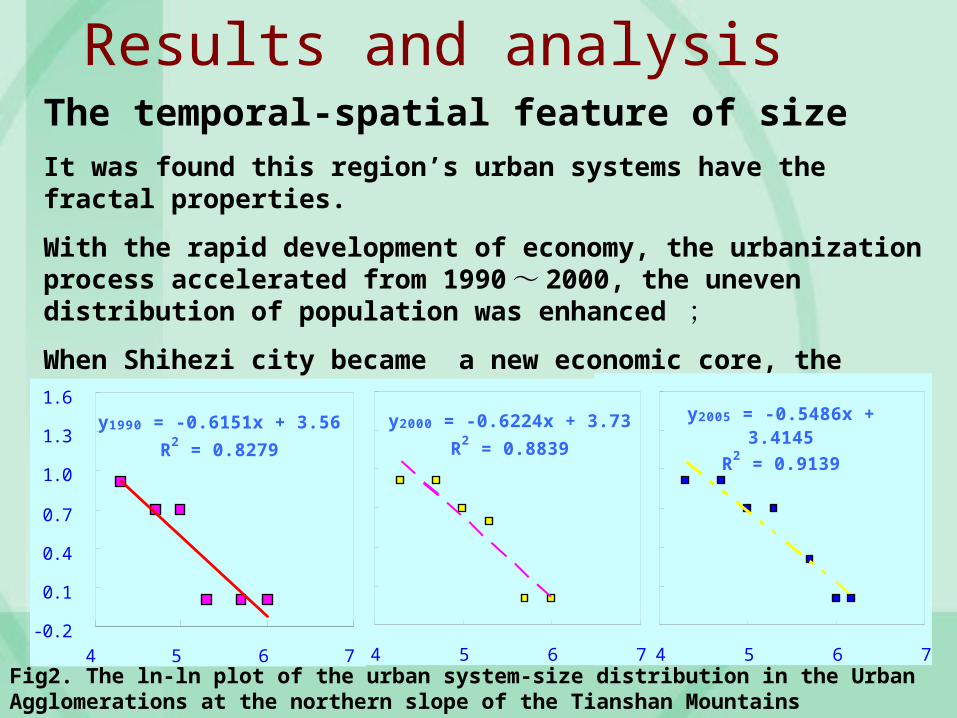
Results and analysisThe temporal-spatial feature of sizeIt was found this region’s urban systems have the fractal properties.
With the rapid development of economy, the urbanization process accelerated from 1990 ~ 2000, the uneven distribution of population was enhanced ;
When Shihezi city became a new economic core, the effect of polarization population was decreased from 2000 to 2005.
Fig2. The ln-ln plot of the urban system-size distribution in the Urban Agglomerations at the northern slope of the Tianshan Mountains
y2005 = - 0. 5486x +3. 4145
R2 = 0. 9139
- 0. 2
0. 1
0. 4
0. 7
1. 0
1. 3
1. 6
4 5 6 7
y2000 = - 0. 6224x + 3. 73
R2 = 0. 8839
- 0. 2
0. 1
0. 4
0. 7
1. 0
1. 3
1. 6
4 5 6 7
y1990 = - 0. 6151x + 3. 56
R2 = 0. 8279
- 0. 2
0. 1
0. 4
0. 7
1. 0
1. 3
1. 6
4 5 6 7

Results and analysis
The urban functional structure changes
Using data of the urban work force structure, statistical analysis, combining J. W. Maxwell and H. J. Nelson's the city classification methods, the authors reveal the urban functional structural characteristics from 1990 to 2005.
Table1 . The categorization of national industries classification
Department Indusry Department Indusry
Construction Construction Transportation Transport, Storage and Post
Business
Wholesale and Retail Trades
Administration
Public Management and Social Organizations
Hotels and Catering ServicesWater Conservancy, Environment and Public Facility Management
Industial
Mining
Service
Services to households and Other Services
Production and Distribution of Electricity,Gas and Water
Scientific Research, Technology Service and Geological Prospecting
Manufacturing Information Transmission,Computer Servcie and Software
Education, sciecen,culture and health
Education Real Estate
Health, Social Security and Social Welfare
Financial Intermediation
Culture, Sports and Entertainment
Leasing and Business Services

Results and analysis
Table2. The industrial location entropy of urban agglomerations at the northern slope of the Tianshan Mountains in 1990 and 2005
City
Construction Transportation Business Administration Industial Service Education and science
2005 1990 2005 1990 2005 1990 2005 1990 2005 1990 2005 1990 2005 1990
Urumqi 1.1 1 1.4 1.1 0.9 1.2 0.6 1.2 0.8 0.9 1.2 1.2 1.2 1
Shihezi 1.2 1.4 0.4 0.7 0.6 0.8 1.6 0.5 1.2 1.1 0.8 0.5 1 1.2
Kuytun 0.4 1.6 1.4 0.7 3.9 0.9 1.7 0.8 0.7 1 0.9 0.6 0.6 1.1
Miquan 2.5 0.6 0.1 0.9 0.2 1.1 1.9 0.9 0.7 1.2 0.4 0.8 1.2 0.9
Fukang 0.6 0.5 0.4 0.5 0.4 0.8 2.3 0.7 1.3 1.4 0.6 0.5 1.2 0.9
Karamay 0.9 0.6 0.1 1 0.5 0.4 0.9 0.8 2 1.4 0.5 0.7 0.5 0.9
Usu 1.4 0.6 0.7 1.4 2.8 1.3 1.4 1.5 1 0.8 0.5 1.1 0.4 1.4
The structure urban functional changes

Table3. The functional structure changes of urban agglomerations at the northern slope of the Tianshan Mountains in 1990 and 2005
CityDominant function Leading function
1990 2005 1990 2005
Urumqi Industrial Industrial Industrial Industrial
Transportation Transportation
Construction Services
Shihezi Industrial Industrial Industrial Industrial
Construction
Karamay Industrial Industrial Industrial Industrial
Fukang Industrial Industrial Industrial Industrial
Administration
Education and science
Changji Industrial Industrial Industrial Industrial
Construction Administration
Services
Miquan Industrial Construction Industrial Construction
Services
Construction
Kuytun Industrial Business Industrial Transportation
Construction Business
Usu Industrial Industrial Industrial Industrial
Transportation Business
Business

Results and analysis
The urban functional structure changesUsing data of the urban work force structure, statistical analysis, combining J. W. Maxwell and H. J. Nelson's the city classification methods, the authors reveal the urban functional structural characteristics from 1990 to 2005.
The urban economic structure is similar that the leading sector is industry and sectors with superiority are transportation and business industry.
But the dominate function became diversified.

Results and analysisThe macroscopic distribution characteristicsThe city always along with oasis , road and railway(Fig3•a) 。( 1) Be near the watershed of the mountain systems and lies on the upstream of piedmont alluvial-pluvial fan which is rich in water resource, plantation and good at soil texture. Where is oasis and where is city.
( 2) The water resource and rivers distribution impact on the urban expansion direction and the shape of the oasis city significantly.The urban expansion direction is along the river basin.The shape of the city is long strip which the length is more than broad 。

Results and analysisThe macroscopic distribution characteristics
No matter in ancient times or in the contemporary era, the traffic impact deeply and significantly on the congregation, interaction and distribution of the oasis city.
Based on the methods of Hausdorff fractal dimension and space relation fractal dimension, the paper adopt calculation models on the fractal dimension and the arriving degree of road network .
(2)
r is radial distance, When D→1 , Many elements of the city system are concentrated on single geographical elements such as river, railway ; When D→2 , the distribution of city is even [4] 。
When r’ is communication distance, :arriving degree of network, when it close to 1 , the capacity of urban transportation is better , and the correlation of elements between cities is stronger.
)log(
loglim
)(
r
rcD
DD

l ogC( r2)= 0. 5818l ogr2 + 0. 2644
R2 = 0. 9744
1. 2
1. 4
1. 6
1. 8
2. 0
1. 5 1. 7 1. 9 2. 1 2. 3 2. 5 2. 7
l ogC( r1) = 0. 6253l ogr1 + 0. 1827
R2 = 0. 9369
1. 2
1. 4
1. 6
1. 8
2. 0
1. 5 1. 7 1. 9 2. 1 2. 3 2. 5 2. 7
Results and analysisThe macroscopic distribution characteristics
( 3 ) The traffic artery become another element impacting the distribution of oasis cities. In the study area, the city density is relatively high, the communication is very well and approximately straight line form 。
Fig3 The ln-ln plot on the spatial distribution of 8 main cities at the northern slope of the Tianshan Mountains
9301.0

Results and analysisThe macroscopic distribution characteristics
Fig4. City group distribution (a) and spatial structure (b) of urban agglomerations at the northern slope of theTianshan Mountains

Results and analysisThe microstructure interaction characteristics
Spatial structure of regional economy characteristic :
Fig4. City group distribution (a) and spatial structure (b) of urban agglomerations at the northern slope of the Tianshan Mountains
The whole shape : “Dumbbell”
Two main economic cores:
Urumqi metropolitan Areas
Economic zone of Kuytun, Usu and Dushanzi
Another is growing: Economic region of oasis urban groups including Shihezi city , Shawan county and Manasi county

Conclusions and suggestion
( 1 ) The rank-scale distribution and spatial interaction has fractal character.
( 2) The feature of hierarchical structure is loosing, primate city distribution, and the uneven population distribution. But from 1990-2005, the population centre changed from single to multi-center.
( 3 ) However the functional division in urban agglomerations is not very distinctness. The urban economic structure is similar that the leading sector is industrial. The urban functional structure is developing and perfecting and the dominate function became diversified.

Conclusions and suggestion
( 4 ) The spatial distribution is linear , and the mostly cities lie on a geographic element as rivers, railway and national artery ; The connectivity degree is relatively strong. The display of spatial organizational structure is belt, integration of partial and whole, concentration of megalopolis and economic zone.
( 5 ) According to the conditions of resources and situation of development, the developmental strategy should be as follows:
To give priority to develop new sub-central cities such as Usu, Fukang,
To accelerate the national city-Urumqi, entirely play roles of radiation of central cities.
To pay more attention to develop the diversification of urban function

Thanks for your attention!


![FOREIGN BROADCAST If uirf/ INFORMATION …Textile Industry Adjusts Product Structure [XINJIANG RIBAO 16 Mar] 11 Xinjiang Official Describes Causes, Solutions to Inflation [XINJIANG](https://img.pdfslide.us/doc/110x75/5fb5b3e123d56a3a9d730569/foreign-broadcast-if-uirf-information-textile-industry-adjusts-product-structure.jpg)
![Prehistoric Interactions in Eurasia: A Re-evaluation of ...Xinjiang Wenwu Kaogu Yanjiusuo [Xinjiang Institute of Archaeology] (Urumqi: Xinjiang meishu shejing chubanshe 1997: 44-56)](https://img.pdfslide.us/doc/110x75/5f18bffb0b48650cc441aaeb/prehistoric-interactions-in-eurasia-a-re-evaluation-of-xinjiang-wenwu-kaogu.jpg)