Embed Size (px)
Citation preview

ANALYSIS OF URBAN MORPHOLOGY IN SQUATTER TRANSFORMATION
AREAS
A THESIS SUBMITTED TO
THE GRADUATE SCHOOL OF NATURAL AND APPLIED SCIENCES
OF
MIDDLE EAST TECHNICAL UNIVERSITY
BY
IN PARTIAL FULFILLMENT OF THE REQUIREMENTS
FOR
THE DEGREE OF MASTER OF SCIENCE
IN
URBAN DESIGN
IN
CITY AND REGIONAL PLANNING
MAY 2014

Approval of the Thesis:
ANALYSIS OF URBAN MORPHOLOGY IN SQUATTER TRANSFORMATION
AREAS
submitted by MUSTAFA RASIT SAHIN in partial fulfillment of the requirements for
the degree of Master of Science in Department of Urban Design, City and Regional
Planning, Middle East Technical University by,
Dean, Graduate School of Natural and Applied Sciences ___________________
Prof. Dr. Melih Ersoy
Head of Department, City and Regional Planning ___________________
Assoc. Prof. Dr.
Supervisor, City and Regional Planning Dept., METU ___________________
Examining Committee Members:
Assoc. Prof. Dr.
City and Regional Planning Dept., METU ____________________
Assoc. Prof. Dr.
Supervisor, City and Regional Planning Dept., METU ____________________
Assoc. Prof. Dr. M. Adnan BARLAS
City and Regional Planning Dept., METU ____________________
Assoc. Prof. Dr. Nil UZUN
City and Regional Planning Dept., METU ____________________
Can Kubin, M.Sc.
City and Regional Planning Dept., METU ____________________
Date: 20 May 2014

iv
I hereby declare that all information in this document has been obtained and
presented in accordance with academic rules and ethical conduct. I also declare
that, as required by these rules and conduct, I have fully cited and referenced all
material and results that are not original to this work.
Name, Last Name: MUSTAFA RAŞİT ŞAHİN
Signature:
v
ABSTRACT
ANALYSIS OF URBAN MORPHOLOGY IN SQUATTER TRANSFORMATION
AREAS
Şahin Mustafa Raşit
M.S., Department of Urban Design
Supervisor: Assoc. Prof. Dr. Emine Yetişkul Şenbil
May 2014, 169 pages
The impacts and results of urban transformation have been discussed as an important
issue in developing countries by different disciplines as political economy, urban design,
city planning and urban sociology. Urban transformation projects in Turkey are mainly
criticized since the main focus is about physical transformation. In this context, the aim
of the study is to determine what quality of space is produced by urban transformation
projects in Turkey. Urban transformation projects create a different scale, scope and
content of space that the environmental and structural quality generally raises with
respect to squatter settlements. Urban morphology deals with the spatial structure and
character of an urban area by examining its patterns and the process of its development.
Furthermore, it gives clues about the social space constructed in the physical space. Two
main transformation models have been implemented to solve the squatter problem in
Turkey as the large-scale redevelopment projects and the partial implementation plans.
In this study, via urban morphology and urban design analysis tool, the quality of spaces
created through urban transformation projects are investigated by analyzing and
comparing transformed areas in Turkey with an existing squatter settlement which is
Antakya, Bagriyanik district.
Keywords: Urban transformation, urban morphology, Antakya, Bağrıyanık District,
Squatter settlements, Urban design

vi
ÖZ
KENTSEL DÖNÜŞÜM ALANLARINDA KENT MORFOLOJİSİNİN İRDELENMESİ
Şahin, Mustafa Raşit
Yüksek Lisans, Kentsel Tasarım
Tez Yöneticisi: Doç. Dr. Emine Yetişkul Şenbil
Mayıs 2014, 169 sayfa
Gelişmekte olan ülkelerde kentsel dönüşümün etkileri ve sonuçları siyasal ekonomi,
kentsel tasarım, kent planlama ve kent sosyolojisi gibi farklı disiplinlerde önemli bir
olgu olarak tartışılmaktadır. Türkiye’de kentsel dönüşüm projelerine dair yapılan
eleştiriler genel olarak projelerin fiziksel mekân dönüşümü odaklı olmasıdır. Bu
bağlamda çalışmanın amacı Türkiye’de kentsel dönüşüm projeleri vasıtasıyla üretilen
mekânların kalitesinin irdelenmesidir. Kentsel dönüşüm projeleri, gecekondu
yerleşmelerinin çevresel ve yapısal kalitesini arttırmakla beraber daha farklı bir ölçek,
kapsam ve mekânsal içerik yaratmaktadır. Kent morfolojisi doku ve gelişim süreçlerini
irdeleyerek kentsel alanın mekânsal yapısı ve karakteriyle uğraşmaktadır. Ayrıca,
fiziksel mekânda kurulan sosyal mekâna dair ipuçları vermektedir. Türkiye’nin
gecekondulaşma ve çözüm sürecinde iki temel dönüşüm modeli görülmekte olup, bunlar
geniş ölçekli kentsel dönüşüm projeleri ile parçacı yaklaşımı olan ıslah imar planlarıdır.
Bu çalışmada kent morfolojisi ve kentsel tasarım araçları vasıtasıyla Türkiye’de kentsel
dönüşüme uğramış alanlar ile Antakya Bağrıyanık örneğini içeren dönüşüme uğramamış
alanların karşılaştırılması yoluyla kentsel dönüşüm projeleriyle üretilen mekân kalitesi
irdelenmektedir.
Anahtar Kelimeler: Kentsel dönüşüm, kent morfolojisi, Antakya, Bağrıyanık Bölgesi,
Gecekondu alanları, Kentsel tasarım

vii
To 301 Mine Workers,
Died in Soma, Manisa, Turkey
13.05.2014

viii
ACKNOWLEDGMENTS
I would like to express my deepest gratitude to my advisor, Assoc. Prof. Dr. Emine
Yetişkul Şenbil, whose expertise, understanding, patience added considerably my
graduate experience. The words cannot express my heartfelt gratitude, gratefulness for
her priceless guidance and support in my life.
I also want to thank Prof. Dr. Baykan Günay, who guided and encouraged me
constantly. Finally, I want to thank my professors and coworkers in the City and
Regional Planning Department and Urban Design for making this work possible.

ix
TABLE OF CONTENTS
ABSTRACT .………………………………………………………………………….....v
ÖZ ……………………………………………………………………………………….vi
DEDICATION ………………………………………………………………………... vii
ACKNOWLEDGMENTS ……………………………………………………………..viii
TABLE OF CONTENTS ……………………………………………………………….ix
LIST OF TABLES ………………………………………………………………….....xiii
LIST OF FIGURES …………………………………………………………………....xiv
CHAPTERS
1. INTRODUCTION ...…………………………………………………………1
1.1. Problem Statement ………………………………………………………2
1.2. Hypothesis, Aim and Scope of the Study ……………………………….4
1.3. Method and Data Resources …………………………………………….6
1.4. Structure of the Study …………………………………………………...9
2. URBAN FORM AND MORPHOLOGY …………………………………..11
2.1. Analysis of Urban Form ……………………………………………….11
2.2. Evaluation of Urban Form ……………………………………………..12
2.2.1. Classical Times …………………………………………………..12
2.1.1. Medieval Times ………………………………………………….13
2.1.2. Renaissance and Baroque ……………………………………….15
2.1.3. Industrialization ………………………………………………….17
2.1.4. Modernism ……………………………………………………….18
2.1.5. The New Urbanism ...……………………………………………19
2.3. The Effects of Urban Formation …………………………………………...20
2.4. Types of Urban Form ……………………………………………………...22
2.5. Urban Morphology ………………………………………………………...27
2.5.1. The Figure-ground Theory ……………………………………….29

x
2.5.2. The Linkage Theory ……………………………………………...31
2.5.3. The Place Theory ………………………………………………...32
2.5.4. Main Approaches in Urban Morphology ……………………….. 33
2.6. Social Aspects of Urban Morphology ……………………………………. 40
2.6.1. Issues of Urban Morphology ...…………………………………..41
2.6.2. Social Roles in Space …………………………………………… 43
2.7. Regenerative Role of Community Design …………………………………46
3. SQUATTER HOUSING IN TURKEY ……………………………………………49
3.1.Definition of Squatter Housing …………………………………………….49
3.1.1. Turner Approach ……………………………………………….50
3.1.2. Burgess Approach ……………………………………………...51
3.1.3. Other Approaches ………………………………………………52
3.2. Development Process of Squatter Housing ..………………………………54
3.3. Historical Background of Squatter Housing in Turkey …...……………….55
3.3.1. 1950-1960 Period ………………………………………………55
3.3.2. 1960-1980 Period ………………………………………………57
3.3.3. 1980-1990 Period ………………………………………………59
3.3.4. After 1990 Period ………………………………………………60
3.4.Policies in Urban Built-Up Areas …………………………………………..63
3.4.1. Policies towards Squatter Housing ……………………………..63
3.4.2. Urban Transformation Policies …………………………………65
3.4.3. Negative Social Impacts of Urban Transformation Policies …...68
3.5.Policies for Squatter Housing in Turkey …………………………………...70
3.5.1. Policies until 2000s ……………………………………………..70
3.5.1.1. Squatter Law No. 775 ………………………………….72
3.5.1.2. Amnesty Law No. 2981 ………………………………..73
3.6.Urban Transformation Process ……………………………………………..74
3.6.1. Law on Metropolitan Municipalities No. 5216 ………………...75

xi
3.6.2. Municipality Law No. 5393 ……………………………………76
3.6.3. Law concerning the Urban Regeneration Project of Northern
Ankara Entrance No. 5104 ……………………………………..77
3.6.4. Law on Redevelopment of Areas under Risk No. 6306 ………..78
4. URBAN RENEWAL AND TRANSFORMATION EXAMPLES OF SQUATTER
AREAS IN TURKEY ………………………………………………………………83
4.1. Dikmen Valley Housing and Environmental Development Project Area …83
4.1.1. Evaluation of the Project ……………………………………….92
4.1.1.1.Strengths ………………………………………………..92
4.1.1.2.Weaknesses ……………………………………………..92
4.1.2. Morphological Evaluation of the Dikmen Valley Project ……...94
4.1.2.1. Figure and ground Analysis ……………………………96
4.1.2.2. Linkage Analysis ………………………………………98
4.1.2.3. Place Analysis …………………………………………99
4.2.Şentepe Urban Transformation Project …………………………………...101
4.2.1. General Information of the Site ……………………………….104
4.2.2. Morphological Evaluation of the Şentepe Urban Transformation
Project …………………………………………………………109
4.2.2.1. Figure and Ground Analysis ………………………….110
4.2.2.2. Linkage Analysis ……………………………………..111
4.2.2.3. Place Analysis ………………………………………..112
5. ANTAKYA BAGRIYANIK DISTRICT …………………………………………115
5.1. General Information of Antakya ………………………………………….115
5.2. Historical Evolution of City and Its Morphology …………………………117
5.2.1. Early Times …………………………………………………...117
5.2.2. The Byzantium and Islamic Period …………………………...119
5.2.3. French and Republican Period ………………………………...121
5.2.4. Present Morphology of the City ………………………………122

xii
5.3. Morphological Typology of Antakya ……………………………………..126
5.4. Morphological Analysis of the Transformation Projects in Antakya ……..131
5.5. General Information of the Case Study Area ……………………………..135
5.6. Morphological Features of the Case Study Area ………………………….140
5.6.1. Figure and Ground Analysis …………………………………..142
5.6.2. Linkage Analysis ……………………………………………...143
5.6.3. Place and Urban Design Analysis …………………………….145
6. CONCLUSION …………………………………………………………………...151
6.1. Concluding Remarks ……………………………………………………...151
6.2. Further Comments ………………………………………………………...163
7. REFERENCES ……………………………………………………………………166

xiii
LIST OF TABLES
Table 1.1: Research Design of the Study ………………………………………………..7
Table 3.1: Framework of transformation of squatter housing problem in Turkey ……..62
Table 3.2: Urban Transformation Process Reproduced by Lichfield …………………..68
Table 3.3: Targets and results of Improvement Laws ………………………………….71
Table 3.4: Summary of Squatter Housing Phenomenon ……………………………….80
Table 3.5: Summary of Squatter Housing Laws Enacted in Turkey …………………...81
Table 4.1: Distribution of Land Uses …………………………………………………108
Table 5.1: Examples of Urban Patterns from Antakya ………………………………..129
Table 5.2: Examples of Urban Patterns from Antakya (Continued) ………………….130
Table 6.1: Summary of the Morphological Analysis …………………………………159

xiv
LIST OF FIGURES
Figure 1.1: Diagram of Urban Design Theories …………………………………………8
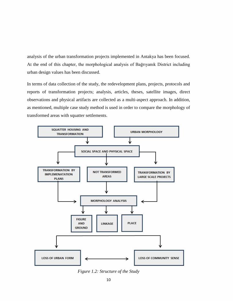
Figure 1.2: Structure of the Study ……………………………………………………...10
Figure 2.1: The Ideal city; Filarete’s plan of Sforzinda ………………………………..16
Figure 2.2: Chinese Theory …………………………………………………………….24
Figure 2.3: Plan of Priene, 450 BC ……………………………………………………..25
Figure 2.4: Urban Morphology Theories ……………………………………………….29
Figure 2.5: Example of Figure and Ground Theory Representation……………………30
Figure 2.6: Representation of Linkage Theory …………………………………………32
Figure 2.7: Representation of Place Theory ……………………………………………33
Figure 2.8: Cullen’s Serial View ……………………………………………………….35
Figure 2.9: The City Image …………………………………………………………….38
Figure 2.10: Gestalt Laws of Form ……………………………………………………..39
Figure 3.1: Urban Transformation Project of Northern Ankara Entrance ……………...78
Figure 4.1: Location of Dikmen Valley in Ankara ……………………………………..84
Figure 4.2: View of the Gececondus in Dikmen Valley.……………….………...…….85
Figure 4.3: The first City Development Plan of Ankara (1932) ………………………..86
Figure 4.4: The“2025 Master Plan for the Metropolitan Area” (1993) ………………...87
Figure 4.5: Left: Dikmen Valley Development Plan, The 1991 approved project of the
Dikmen Valley and main infrastructure: the Yildiz-Oran Axis the study of the
subdivision of the land ownership ……………………………………………………...88
Figure 4.6: Implementation zones of the Project ……………………………………….90
Figure 4.7: Bridge of the Valley ………………………………………………………..94
Figure 4.8: Satellite Image of the Morphological Analysis Study drom Dikmen Valley
Project …………………………………………………………………………………..96
Figure 4.9: Figure and Ground Analysis of Dikmen Valley Project …………………...97
Figure 4.10: Linkage Analysis of Dikmen Transformation Project Site ……………….98

xv
Figure 4.11: Place Analysis of Dikmen Transformation Project Site ………………100
Figure 4.12: Location of Şentepe District with respect to Central Area ……………101
Figure 4.13: Tissue of Şentepe District ………………………………………………103
Figure 4.14: The Transformation Process in Şentepe District ………………………104
Figure 4.15: The Third Stage of Urban Transformation Project, Çiğdemtepe
Neighborhood …………………………………………………………………………105
Figure 4.16: The Development Plan of the 3. Stage of the transformation project (Report
of Şentepe Urban Transformation Project, Yenimahalle Municipality ………………106
Figure 4.17: Transformed Apartments in Şentepe ……………………………………107
Figure 4.18: The Conceptualized Transformation of Urban Fabric Through Improvement
Plans in Şentepe ………………………………………………………………………109
Figure 4.19: Figure and Ground Analysis from Şentepe Urban Transformation
Project………………………………………………………………………………….111
Figure 4.20: Linkage Analysis from Şentepe Urban Transformation Project ………113
Figure 4.21: Place Analysis from Şentepe Urban Transformation Project …………...114
Figure 5.1: Land Use Pattern of Antakya ……………………………………………..116
Figure 5.2: Plans of Ancient Antioch …………………………………………………118
Figure 5.3: Map of Antioch in early 20th century ……………………………….……120
Figure 5.4: Map of Antakya in 1931 ………………………………………………….122
Figure 5.5: The urban pattern of “Uzun Çarşı” during French Mandate Period ……...124
Figure 5.6: The Urban Pattern of Antakya ……………………………………………125
Figure 5.7: Urban Pattern Analysis of Antakya ………………………………………128
Figure 5.8: Development Right Status of Area 1 ……………………………………..131
Figure 5.9: Development Right Status of Area 2 ……………………………………..132
Figure 5.10: Morphological analysis of “Area 1” from Antakya ……………………..133
Figure 5.11: Morphological analysis of “Area 2” from Antakya ……………………..134
Figure 5.12: Case Study Area in the City ……………………………………………..135
Figure 5.13: Land Use Analysis of Bağrıyanık District ………………………………136

xvi
Figure 5.14: High and Middle Income Residential Areas close to Case Study Area….137
Figure 5.15: Low quality commercial and residential uses in the neighborhood ……..138
Figure 5.16: Topographical features of the district …………………………………...139
Figure 5.17: Urban Pattern of the Case Study Area and Close Surrounding …………141
Figure 5.18: Figure and Ground Analysis of the Bağrıyanık District ………………...142
Figure 5.19: Linkage Analysis of Bağrıyanık District ………………………………..144
Figure 5.20: Place Analysis of Bagriyanik District …………………………………...146
Figure 5.21: Main node of the neighborhood …………………………………………147
Figure 5.22: Gestalt Analysis of Bağrıyanık District …………………………………148
Figure 5.23: Socializing nodes of “Tandır” and contuinty of organic roads…………..149
Figure 5.24: Analysis of Character and Identity of Bağrıyanık District ……………...150
Figure 6.1: Different Design sketches on regeneration alternatives of Bağrıyanık
District…………………………………………………………………………………165


1
CHAPTER 1
INTRODUCTION
“Dynamics of the economic structure and ever evolving activities, further highlighted
by the mobility of social classes turns the city into an arena of conflicts. Under these
circumstances the city produces and reproduces itself. Consequently there has always
been a need for some kind of action by the related public agencies with reference to the
regeneration or reproduction or transformation of the urban environment.” (Günay,
2009)
Cities and their parts emerge, grow, decline and regenerate or die in a cyclical fashion
since urban arena is always subject to change. Cities are formed with the agglomeration
of specialized various uses. However, the major use having the highest share in land use
of built environment is residential areas. The physical and social pattern of the
residential quarters in cities reflects the wealth, status and culture of the city. The right to
housing is codified as a human right in the Universal Declaration of Human Rights
(HABITAT, 2000). Thus, the human right to access adequate housing is the right of
everyone. However, affordability housing is limited in urban areas and public housing
provision could not meet housing demand. Even though, one of the main missions of
local and central governments is to plan urban development and provide housing for
their citizens, unauthorized housing development is urgent when the authorized housing
provision and the number of houses produced through legal processes are inadequate to
meet the demands of urban citizens.

2
Urban redevelopment has deep roots that the famous burning of Rome on the night of
July 18 (or 19) in AD 64 might be considered as an early example of “systematic slum
clearance project” (Mumford, 1966, 255; cited in Günay, 2009). The role of
redevelopment throughout the history can be explained as the re-creation of decayed
parts of cities. In Turkey, like other developing and under-developed countries, squatter
housing is an important problem. Turkey has been dealing with squatter problem since
1950s via different intervention approaches including clearance, redevelopment and
legitimization. In fact, two models of transformation in squatter settlement areas have
been implemented with a wide range of examples in last decades in Turkey as;
transformation by improvement and redevelopment plans and transformation by large
scale transformation projects.
Urban space can be understood in two dimensions as social space and built space. The
social space can be identified as the spatial implication of social institutions while the
built space or physical space can be defined as morphology, the way it affects our
perceptions, the way it is used and the meanings it can elicit (Colquhoun, 1989, p. 223;
cited in Madanipour, 2000). Madanipour (1996, p. 3) defines urban design as a socio-
spatial process understood as an agglomeration of people, objects and events. He also
identifies that environment cannot be perceived as unrelated collection of material
objects; on the other hand, space cannot be only regarded as a container of social
relations without a physical dimension. The squatter housing as a phenomenon and
squatter housing transformation as a process of urban change both involves physical and
social aspects of urban space.
1.1. Problem Statement
Squatter housing development is a widespread problem in many Third World Countries
and in Turkey as well. The problem appeared especially due to the rapid urbanization in

3
metropolitan areas after the Second World War. Moreover, in Turkey the legalization of
squatter settlements and transformation of these settlements have become the main urban
development policies of the governments from the 1980s. Two main models have been
implemented to solve the squatter problem in Turkey. Both models were developed with
popular political approaches. The first one came true after the distribution of title deeds
and approval of improvement plans, prepared according to law numbered 2981. Increase
in the development rights of squatter areas brought the demolition and reconstruction in
these areas. The first model aims to provide a rapid transformation of squatter areas by
private contractors. After 1980s, 'transformation projects' appeared for renewal of these
areas which could not be transformed by private market forces. This model involves
organization and cooperation of stakeholders through public-private partnerships. One of
the characteristics of the latter transformation model was the involvement of central and
local governments in the processes as a profit. These self-financing projects generated
surpluses that were also shared by local governments, private companies and squatter
owners. On the other hand, by improvement plans, the rent was shared between the land
owners and small contractors.
In the 2000s, the transformation projects were both accelerated and enlarged in scale.
Moreover, the generated rents were increased by a more centralized approach mainly
governed by Housing Development Administration. In 2012, the amnesty laws were
replaced by a new law “Urban Transformation Law for Areas with Disaster Risk”
numbered by 6306. The scope and scale of urban transformation were enlarged and the
government intervention in urban development increased. Furthermore, squatter
settlement areas located not only in the center of the cities but also in the periphery
became subject to urban transformation projects.
Urban transformation processes are generally criticized that the projects have developed
with a physical scope and the social, economic and cultural impacts of the projects have

4
not been discussed. Affordability in housing provision, displacement of lower income
groups, social infrastructure provision and quality of life have not been on the agenda.
Although, a group of literature focused on the urban policy dimension of the
transformation projects, the research in analyzing the spatial results of the projects were
limited.
Urban design is not confined to the investigation of urban physical space apart from
social, cultural and economic dynamics. Madanipour (1996) explains urban design as a
socio-spatial process understood as an agglomeration of people, objects and events (p.
3). Similarly urban Design Tas Force (2000) points out that the best way to promote
successful and sustainable regeneration, is to think about urban design from the start of
the planning and development process. Thus, whether the focus of the projects is
physical or not, investigation and analyses of the morphological results of urban
transformation may also be discussed. Moreover, what is replaced by those projects can
be also evaluated. Since social and physical space of an urban area have an integrated
relationship, the morphology erased and created are also issues of successful
regeneration.
1.2. Hypothesis, Aim and Scope of the Study
Under the light of above mentioned points, the main question of the study is determined
as; “How the urban space has been transforming in the squatter settlement areas?”
According to this main research question, other sub-questions can be expressed, such as
“Urban transformation policies have generated better quality of urban spaces?”, “How
the social-space has changed through urban transformation projects?”, “What kind of
morphological features in urban transformation areas has been formed through
improvement plans and large scale redevelopment projects”.

5
According to the main research question and the sub-questions, the hypothesis of the
research is determined as “Urban transformation processes in Turkey, do not create
better quality of physical space with respect to urban design criteria”.
As mentioned in current literature, urban transformation processes in Turkey have not
been developed with a focus of physical space changes. Thus, the major aim of this
study is to test the hypothesis by comparing the urban forms of transformation projects
with the form of squatter settlements. Both social and physical aspects are emphasized in
the evaluation of urban morphology. Under the umbrella of the major aim, the study is
integrated with the spatial and social evolution of two typical transformed areas and a
squatter site in Turkey. Morphological features as well as urban design values of these
cases are analyzed.
This research also aims to provide a table of criteria for the evaluation of urban
transformation areas. This table covers the items related to social strengths and
weaknesses of urban transformation projects as well as the morphological values
including urban design elements. By this way, the success level of urban transformation
projects in squatter settlements can be measured.
In this study, I concentrate on the transformation of residential areas since a significant
portion of the building stock is composed of residential areas. Besides, practices in urban
transformation in Turkey up until now are mostly the transformation of residential areas.
In this respect, the study begins with a review of the main concepts of „urban form‟. The
evolution of urban form through the development and evolution of cities, the elements
creating or affecting the forms are discussed. In addition to urban morphology concepts,
the role of urban morphology in urban regeneration is investigated. Then the squatter
housing and its legal frame in Turkey, the tools to intervene into squatter problem are
investigated. Then two examples of urban transformation projects are analyzed and the

6
main case study area, Antakya Bağrıyanık District which has not been subjected to
development pressure or transformation regulation is examined in terms of
morphological features. The conclusion covers the results, found by the comparison
between the transformed and non-transformed areas.
1.3. Method and Data Resources
Case studies can be designed as a single example or multiple examples, where a
multiple-case design follows a replication rather than sampling logic. Tellis (1997)
assets that multiple cases strengthen the results by replicating the pattern-matching, thus
it increases confidence in the robustness of the theory. In this study three cases are
selected that two of them are control cases.
The first control case is the Dikmen Valley Urban Transformation Project. The project is
selected as a control case due to two reasons. Firstly, all stages of the transformation
project have not been completed so the non-transformed parts can be still visualized and
observed. Secondly, the project is a well-known and typical example of large scale urban
transformation projects in Turkey. The project is a model for private-public partnership,
including social aims and public participation.
The second control case is the Şentepe Urban Transformation Project which is a typical
example of urban transformation by improvement plans. The project is reliable as a
control case since the complete transformation of the area has not been completed that
the process of changes in terms of urban morphological elements can be easily
visualized and observed. Furthermore, the project can be regarded as a typical example
of urban transformation model conducted by small contractors on individual parcels via
improvement plans. By control cases, the two major approaches dominate the urban
development in Turkey. Models of urban transformation can be observed as large-scale

7
redevelopment schemes of public-private corporation and transformation by
improvement plans via private sector.
Antakya, Bağrıyanık district, where development pressure is limited and urban
regeneration project has not been developed recently, is selected as the main case study
for this thesis. The case study is selected due to two main reasons. Firstly the area has
characteristic features of squatter settlements in Turkey. Secondly, the area is free from
development pressures since the property rights have not been gained by the inhabitants
due to the status of the district. The district is located on 2-B land in addition to small
lands of treasury and municipality. Thereby, the land is not subject to development and
speculative gains. The use value of the squatters is maximized. Thus, the urban pattern
created only due to choices and needs of inhabitants without regarding any economic
benefits.
Table 1.1: Research Design of the Study
Case Type Case Study Type
Dikmen Valley Urban Transformation
Project
Control Case Multiple-Case
Şentepe Urban Transformation Project Control Case Multiple-Case
Antakya Bağrıyanık District Main Case Multiple-Case
Due to the empirical approach covered in terms of site analysis, the data resources used
for in the study can be listed as;

8
- The redevelopment plans, projects, protocols and reports of transformation
projects;
- Analyses, articles, theses,
- Satellite images,
- Direct observations.
- Physical artifacts
Figure 1.1: Diagram of Urban Design Theories (Source: Roger Trancik, 1986, p.98)

9
1.4. Structure of the Study
To answer the main question and related sub-questions, the research covers four main
chapters. In the following chapter of the study, the description and content of urban
form, its evolution by change in settlement needs and the factors shaping urban form are
discussed. Furthermore, urban morphology theories are investigated, which provides us
a basis for the case study analysis. At the end of this chapter, the effect of urban
morphology on social space has been discussed.
In the third chapter of study, firstly the definition of squatter housing problem has been
discussed under major approaches. Then the development processes of squatter housing
in Turkey have been examined from the 1950s to present. The transformation policies
towards squatter areas have been focused with a short review of the widely known
negative social impacts. By narrowing down the study to Turkish case, the legal frame
of urban transformation in squatter areas of Turkey is investigated.
In the fourth chapter of the study, the control case studies have been introduced. Firstly
the general features of Dikmen Valley Urban Transformation Model which constitutes
an example to large-scale urban transformation projects are explained. The aims, plans,
stages, major strengths and weaknesses of the project are evaluated. Afterwards, the
morphological analysis acquired from literature review is conducted for Dikmen Valley
case study area. The general features, aims, and concept of Şentepe Urban
Transformation Project which is an example of transformation areas, formed by
implementation plans is discussed. Then, the morphological analysis of the case study
areas is finalized.
In the fifth chapter of the study, the main case study has been evaluated as Antakya
Bağrıyanık District. In this part of the study, firstly the main features of Antakya and
historical evolution of the morphology of the city are discussed. Then, morphological
typologies in Antakya are evaluated, including the case study area. The morphological
10
analysis of the urban transformation projects implemented in Antakya has been focused.
At the end of this chapter, the morphological analysis of Bağrıyanık District including
urban design values has been discussed.
In terms of data collection of the study, the redevelopment plans, projects, protocols and
reports of transformation projects; analysis, articles, theses, satellite images, direct
observations and physical artifacts are collected as a multi-aspect approach. In addition,
as mentioned, multiple case study method is used in order to compare the morphology of
transformed areas with squatter settlements.
Figure 1.2: Structure of the Study

11
CHAPTER 2
URBAN FORM AND MORPHOLOGY
2.1. Analysis of Urban Form
Urban form refers to the physical layout and design of urban space. The design of cities
takes into consideration building settings, block and street layout, transportation
networks and structure of green areas and urban design issues. The historical
transformation of urban form mainly regards to socio-political motives. The setout of
urban form, social interaction and their relations in space are important aspects in
analyzing residential areas in cities since both the community and space are inter-related
in many aspects. Therefore, in this chapter we will review different definitions and
conceptions of urban form to understand the cases and relations in its production. Later,
we will discuss urban morphology, the study of urban form and the process in the
formation and transformation of cities. Additionally, the tools and theories for analysis
urban morphology will be given.
Urban form, clearly, corresponds to the shape of urban space. However, it is much more
complex. It refers to the form of highly complicated and dynamic social relations that is
the city, which Lynch defines. As urban form is the subject of many areas like urban
morphology, urban history, architecture and planning, it can be defined in several ways
with different dimensions. The first dimension focuses on urbanism, the human life
experience, activity patterns, and the pace of life of a city, as Milgram (1970) has called
the “atmosphere” of a city. The second one can be told as qualitative aspects like images
and identified in the earlier works of Lynch (1960) and Appleyard (1976), Sandercock

12
(1998) and Tajbaksh (2001). The third dimension covers the three aspects of urban form,
i.e., spatial organization (radial, grid, etc.); density gradients and patterns (monocentric,
polycentric, sprawl, compact city) and other macro form models like those in the works
of Lynch (1954-1990).
While the fourth concerns the distribution of different population groups in space such
as separation, exclusion, and segregation (Sennett 1971), the fifth dimension of urban
form focuses on the distribution and configuration of public space in a neighborhood or
city and elements of public spaces and the relationship between public and private
spaces, which was stated by Banerjee (2001). The sixth dimension relates the grain,
texture and scale of new developments and additions to an existing structure. Finally, the
last dimension is the vernacular architecture helping to define the visual form of the
townscape, which was examined in the works of Kostof (1991).
2.2. Evaluation of Urban Form
2.2.1. Classical Times
Cities were originated in many shapes, ranging from organic forms to rigid regular
forms. Unlike the emergence of the early cities expanding with the articulation of
unplanned residential areas around the religious spaces, the cities that were developed by
rational order represents the basic characteristics of the classical. The term, classical is
used to refer the Greek and Roman period. There were many underlying reasons of these
changes in the formation of urban space. The cosmic system, religion, rituals and
political power are main determinants of urban form. The rationality of the grid in the
street layout comes from the climate conditions of the site. On the other hand, grid-iron
system was used for military purposes in the Roman Empire. In accordance with the
colonial regime, the settlements were subject to the control in a rigid way so the colonial

13
cities were established on a grid-iron plan in the simplicity of high level order. The
general form aspects of an ancient city are described as;
“It is the agora that makes the town a polis. As originated by the Greeks, the polis
introduced an entirely new element into the civilization of the West and the Near East.
This new element, represented by the agora [which was new from the sociological as
well as the architectural viewpoint] . . . was based on the potentialities of a gradually
growing democracy and may be contrasted with the principle of the axis. The latter,
whether in Mesopotamia or in Egypt or during the last Roman centuries, always
represents the architecturally crystallized form of a dictatorial concept of society.”
(Zucker, 1959 pp.33 cited in Crawford, 2005)
Bacon also analyzes the meaning of the pattern of the Roman colonial town as;
“The repetitive module of the regular rectangular blocks which constitute the residential
part of the city sets up a rhythm which is the basis for the composition of the public parts
of the city, the temples, the gymnasia, and the stoats facing inward onto the agoras and
out toward the harbors.” (Bacon, pp75 cited in Crawford, 2005).
2.2.2. Medieval Times
Traditional urbanism corresponds to the medieval age. There is not enough information
about what shape the cities during this long period following the enduring tradition of
the Roman order. Disasters, such as earthquakes in Middle East and the bubonic plague
in Europe caused in decrease in overall population as well as the citizens of the early
cities. These resulted in the development of rational thinking, implying the modern. The
modern became the traditional. Only a few cities were established in Europe until the
end of this medieval age and the growth of existing cities was limited. However, the
roles of cities and hierarchy between them were significantly changed. The lack of
central authority invalidated the idea of hierarchy in the city structure. The planned

14
urban settlements and control in the formation would not be valid anymore. After some
towns had been abandoned for centuries, they were eventually rebuilt. Many cities
would have burned at least once or destructed by earthquakes (Crawford, 2005).
Medieval cities without any control have been the first model of „ordered complexity‟ in
urban context (Caliskan, 2013).
The newly established cities were not created for trade purposes. They were developed
around the garrison towns, built in the 13th and 14th centuries (Crawford, 2005). In
addition to the military purposes the feudal economic division of land also caused in the
new form of the cities. In any case, the unplanned and irregular form of these cities
preserved the aesthetic values in their creation whether it was consciously or not. In this
period, streets were arranged by those who used them so the streets developed according
to the needs of the citizens. The focal point of the city was central square, where the city
hall, principal church, and market, often still be found today were located.
The Roman towns faced to lose their regular morphology. The street alignments didn‟t
change much in short terms; however changes over a span of centuries were more
common. Many Roman colonial towns saw major changes in their street plans after their
establishment, sometimes following the centuries of abandonment. Therefore, some of
the main streets, built during the colonial period have been still keeping their original
forms roughly while some has highly irregular forms (Crawford, 2005). Zucker explains
the logic of the form in the medieval times as;
“Towns that grew up around existing fortifications, churches, or villages tended to be
less regular; towns that were newly founded or based on earlier Roman towns tended to
be more regular.”(Zucker, 1959 pp.67-74 cited in Crawford, 2005)
The irregularity continued as a major urban form till 19th
Century when the first suburbs
had started to develop. However; it is still possible to meet an organic urban pattern of

15
the early times and a regular one, adjacent to each other in urban areas, especially in the
quarters having a long urban history (Kostof, 1991).
2.2.3. Renaissance and Baroque
Renaissance put symmetry, balanced axial compositions into urban form. Morris
emphasized that the primary axial street and direct streets were the basis of Renaissance
urbanism (Crawford, 2005). The other important and significant effect of the
Renaissance in the formation of urban space is the revival of urban square and plaza. In
Renaissance period a few cities were founded, but existing cities grew in a rapid manner
due to the increase in population. The Enlightenment Period, dissolution of the feudal
system and its mono-power, affects the urban form since the social –economic and
political aspects shaped physical space and vice versa.
Investigating an ideal city was an important discourse of this age and exploring
principles for designing conscious data structures was critical. These principles adopted
in the construction of monumental plazas, streets and buildings of Renaissance towns in
Italy, France and Germany (Rosenau, 1983; cited in Akkerman). Ideal physical layouts
of new towns, ideal harmonious communities were envisaged by social and religious
men of the Renaissance. Sir Thomas More‟s Utopia, published in 1516, was accepted as
a starting point and it became a milestone to all notions of ideal communities. Although
the extent to which More was aware of the works on ideal cities of European
contemporaries remains unclear, their overall cultural context was not lost on him
(Akkerman, 2010).

16
Figure 2.1: The Ideal city; Filarete’s plan of Sforzinda (after his Trattato d’architettura,
c. 1464 cited in Akkerman, 2010:276).
Renaissance can be regarded as a distinct era however; Baroque notions had deep
influence on the urban form of 20th century. Renaissance responded to the increasing
population pressure to the old cities with the redefinition of cities with ideal city
approach, on the other hand, the Baroque period introduced an open spatial system
defining the city and its periphery. René Descartes‟s ideas and philosophy influenced the
way of thinking during the Baroque period and later. Even though the changes in the
urban form of this period were not as significant as those came about after the medieval
and Renaissance times, this period with the reference to the revival of the classical was
continuity in spatial design. Planned settlements and straight streets continued to
dominate the urban form, as a reflection of Cartesian logic. The axial streets were
common expression of the state‟s power in urban formation so the strong boulevards
were visible in Baroque period. The importance of axial streets can be explained as;

17
“The avenue is the most important symbol and the main fact about the baroque city, but
in the layout of half a dozen new avenues, or in a new quarter, its character could be re-
defined. In the linear evolution of the city plan, the movement of wheeled vehicles played
a critical part: and the general geometrizing of space, so characteristic of the period,
would have been altogether functionless had it not facilitated the movement of traffic
and transport, at the same time that it served as an expression of the dominant sense of
life.” (Morris, 107 cited in Crawford, 2005).
The changes in transportation system also affected the form of the city as Kostof
explains "The railroad, streetcar, and automobile city made a coherent system out of
radial traffic arteries and girdle streets." (Kostof, 1991 pp. 192 cited in Crawford,
2005). Such a system created a strong downtown center from which the traffic arteries
radiated or added diagonal streets to regular grid as a product of the movement of city-
beautiful movement early in 20th
century. The main difference between the cities in this
period and Renaissance is the sense of direction (Crawford, 2005). Ideal principles of
design to create aesthetic uniformity in urban space were the basis of form control in the
neoclassical period.
2.2.4. Industrialization
Industrialization is one of the main turn points of urbanism as many scholars accept that
industrial revolution is the second urban revolution while sedentarization is the first. The
industrialization put its significant impacts on urban arena rapidly, which resulted in the
decline of urban centers and rise of suburban areas. "Modern" architecture was arising
after the standardization of the construction materials, which was about a century later
than the industrialization. The standardization resulted in the popularity of rectangularity

18
and regular forms in city design again. Thus the streets became more dominant and
important than the square (Crawford, 2005).
“In modern city planning the ratio between the built-up and open spaces is exactly
reversed. Formerly the empty spaces (streets and plazas) were a unified entity of shapes
calculated for their impact; today building lots are laid out as regularly-shaped closed
forms, and what are left over between them become streets or plazas.” (Sitte, pp.87 cited
in Crawford, 2005).
Garden city movement, a method of urban planning that was initiated in 1898 by Sir
Ebenezer Howard in the United Kingdom, was born as a reaction to the poor conditions
of industrial development. Garden cities were intended to be self-contained communities
surrounded by "greenbelts". In addition to the garden city movement, Raymond Unwin
who had a deep appreciation to the medieval forms reflected his ideas in his work, Town
Planning in Practice. Single-family housing was the best contemporary solution
according to him. His thoughts about cities were opposite to Renaissance thinking.
2.2.5. Modernism
Modernism was the era in which the mass production of standardized products started to
affect the urban form all over the world. This was a time of great optimism. It was
expected that technology would end hunger, clean up squalor and eliminate ugliness.
Architects would lead the charge, the Bauhaus, "starting from zero," would reinvent
architecture. Modernism relied upon designs that developed with large numbers of
cheap, identical, machine-made parts. Given the imperative of standardized parts, it was
necessary to seek an uplifting style based on endlessly repeated elements. Modernism
cut the close-relation between the building, block and street.

19
Modernism took up the automobile as an icon for the era. Corbusier (.. ...) reportedly
specified that a car was to be parked in front of his buildings when completion
photographs were taken. Modern architecture and city design were wedded to the
automobile, which was to bring freedom to all. This led directly to Corbusier‟s towers-
in-a-park scheme, with broad highways connecting different parts of the city. Corbusier
proposed to demolish vast swathes of central Paris to impose his broad highways and
towers-in-a-park. This alienating concept was adopted with disastrous results in the post-
war era.
2.2.6. The New Urbanism
The new urbanism was born as a reaction to the shifts to contemporary architecture and
urban planning in an increasing level. It revisited the early 20th century urban forms,
typified by the streetcar suburbs built in the USA in the 1920s. This suburban
development was comparatively dense and close-in residential suburbs built on a grid
plan and connected to downtown by new light-rail lines. The urban design standards that
were prominent until the rise of the automobile in the mid-20th century influenced the
new urbanism. It encompassed principles such as traditional neighborhood design and
transit-oriented development. The automobile was a fact but has not dominated cities
yet; it takes another decade after cars became cheap, convenient, fast, and reliable
enough that city dwellers would build their lives around them. In short, the new
urbanism might be called as the old suburbanism.
The 1920s‟ suburbs that new urbanism tends to rebuild were formed in a basis of
suburban grid. This was emerged not from idealizing the straight streets but from
recognizing the need for a fully-interconnected network of streets. New urbanism
projects are always developed with relatively small blocks and close-knit street network.

20
New urbanism would arise as an organized movement. However, a number of activists
and thinkers were criticizing the modernist planning techniques. Lewis Mumford
criticized the "anti-urban" development of post-war America while Jane Jacobs, writer
of The Death and Life of Great American Cities in the early 1960s, reviewed and
commented the single-use housing projects, large car-dependent neighborhood, and
segregated commercial centers. Post-modernists often criticize new urbanism by calling
it "nostalgic" or "pastiche" of historical styles. Unlike the post-modernists, however,
new urbanists are part of a powerful movement to reform society. New urbanism and
smart growth oppose to suburban sprawl due to the increase in air pollution and energy
consumption.
The new urbanism movement covers contemporary forms of architecture such as the
"New Classicism" or "Traditional Architecture" and historical urban forms, including
the curved streets and pedestrian-oriented neighborhood.
2.3. The Effects of Urban Formation
The form of cities is shaped by the structure of transport network; distribution of public
places in the space and mass produced building units. However, in any case, urban
fabrics are a kind of collective product. As collective city form is a production of
different groups in a long term and distributed process, city form has changed
continuously through the ages. The historical transformation of urban form is related to
actors, instruments and social and political motives. In the formation of urban spaces,
many issues such as social values, philosophy, population size, systems of government,
artistic sensibility, design techniques, building methods, paving techniques, transport
technology, sewage and waste disposal, and energy supply, have a direct or indirect
effect (Crawford, 2005).

21
Military Power: In the formation of cities, the influence of military power on physical
layout has often been large. Military command has sometimes preferred the grid-iron
system or sometimes radial arrangements. For example, the radial form came to be
favored by Renaissance military strategists. On the other hand, straight streets of Roman
grid-iron colonial cities were also preferred for military purposes. Although it is often
noted that irregular streets are easier to defend once the enemy has invaded. In all cases,
wide streets seem to be preferred for the maintenance of civil order (Crawford, 2005).
Property Ownership: The ownership of the land usually exerts a large influence on
decisions regarding how streets are arranged. Major Baroque projects relied on
centralized authority to reassemble land and drive straight boulevards through the
existing urban fabric. Simplified land division favors rectilinear street patterns, but
irrigation is often important and usually related to land ownership patterns and
topography (Kostof (1991) cited in Crawford, 2005).
The organic forms can be regarded as a product of complex and long-handed property
relations. If the people that had the right of usage owned the land before a governmental
institution divided and distributed it (Kostof, 1991) as in the case of Roman colony
towns, an organic form was structured.
Religion and Rituals: In all periods, religious beliefs have often influenced city design
(Crawford, 2005) because social relations are directly linked to religion and rituals. The
sense of privacy and role of public space are related to religion and rituals.
For example, the city of Aosta, a Roman colonial town, originally was laid out on a rigid
grid system. By medieval times it entirely lost its regularity while maintaining some of
its original topology due to depopulation, reduced circumstances, and a social
revolution. The monotheistic religions affected the city as a way that there was no place
in the social structure for theaters, amphitheaters, temples, or (in the Christian case)
baths (Crawford, 2005).

22
Social Relations: The grid-iron system is inflexible in terms of human movement and
people dislike it so shortcuts are created through the partially-occupied grid. This system
decreases the value of public place and its monumental meaning. Moreover, the meaning
of strong patterns and axial streets also diminish. Public foci always affect urban fabric
(Crawford, 2005).
Technology and Circulation: It is can be easily seen that even 500 years ago, traffic had
a major influence on the design of cities. Renaissance urban spaces were grouped under
three broad headings: first, traffic space, forming part of the main urban route system
and used by both pedestrians and horse drawn vehicles; second, residential space,
intended for local access only and with a predominantly pedestrian recreational purpose;
third, pedestrian space, from which wheeled traffic was normally excluded (Crawford,
2005).
The growth and macro-form of cities are mainly dependent on the growth of circulation
systems. The invention of railway and car created the suburbanization movements.
Transportation improvements are products of technological intervention. In addition, the
technology itself affects the urban form such that information technologies also led to
decline of urban centers and creation of world cities.
2.4. Types of Urban Form
Kostof simply identifies the urban form as geometric and non-geometric. Cities can
grow organically out of a village like the growth of a tree. Non-geometric forms are the
result of the incremental changes parallel to life in a slow manner in general (Kostof,
1991). Non-geometric organic form and patterns are generally characterized by medieval
cities and Islamic cities in the same time period. Kostof identifies the unplanned city as a
spontaneous one in a basic manner such as “grown”, “generated” or geomorphic”. The

23
overall layout is produced without any intervention of designers but under the effects of
daily life of citizens. The basic characteristics of irregular, non-geometric and organic
structure can be listed as;
1. Curved streets
2. Random open spaces
3. Random angles.
However, the organic pattern does not only imply an unconscious way of land
acquisition without design matters. Since the organic form reveals high level of
community spirit and social cohesion, it can also be an urban design approach.
The first Mesopotamian towns are thought to be grown in inorganic structure. They
grew around a social agglomeration or an institutional core and expanded by natural or
biological rhythms (Kostof, 1991). On the other hand, early cities did not only expand in
an organic pattern. El Lahun in Egypt, for example, was a dormitory community which
was designed for workers including residential hierarchy, street order with serial housing
units. Moreover, Kostof states that “…cities can have a schematic orthogonal plan
which blocks are roughly equal size and rational distinction was made between main
street and alleys that separated the houses” (1991, pp34).
In addition to the Kostof‟s main division of urban form, Lynch offers normative model
in categorizing the shape of cities (Lynch, 1984). The normative models are defined as,
1. Cosmic Model
2. Practical Model
3. Organic Model
Cosmic model has a holy meaning as it defines the interpretation of universe and the
gods. The cosmic city is characterized by a monumental axis, enclosure, protected gates,

24
dominant landmarks and generally a regular grid. The city is a representation of
psychological power. Lynch illustrates the cosmic cities as the Chinese and Indian cities.
The Chinese model can be seen in China, Japan, Korea and Southeast Asia and the best
prototypes can be found in Beijing, Kyoto and Seoul. While the north symbolized the
dark and unpropitious, the city was divided into regular boxes. The urban space was
divided into two parts; west and east, to figure the government structure. With colors,
shapes, locations and materials the power and religious concerns were symbolized.
Moreover, enclosures, gateways and approaches supported the magical power of order.
Figure 2.2: Chinese Theory (Lynch, 1984, pp 74: Meyer, Wheatley, Wright)
The form of Indian cities was also shaped by spiritual power. However, the examples are
less in number with respect to Chinese model examples. The Silpasastras, the Hindu
architecture, indicates the order of the earth and includes the chaos of evil power which
is symbolized by the figure of Mandala. The most powerful point is the center.
In addition, Kostof categorizes the urban form under three main sub-topics as,
25
1. Organic Pattern
2. The Grid
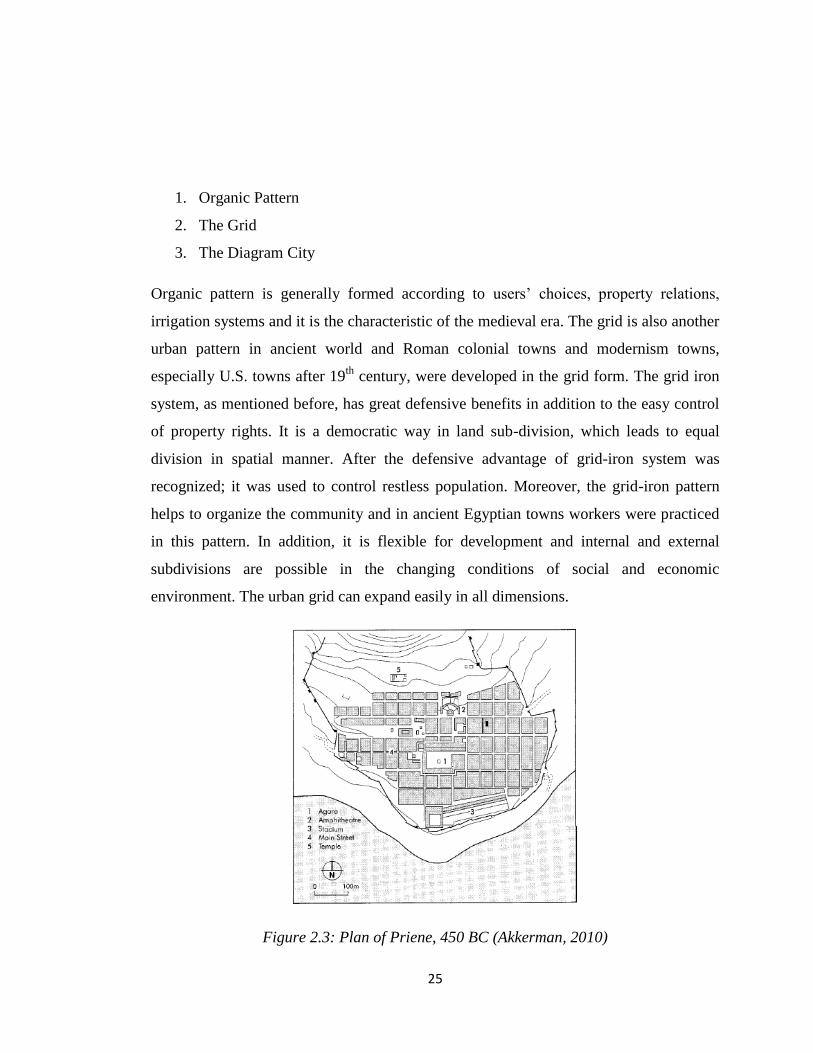
3. The Diagram City
Organic pattern is generally formed according to users‟ choices, property relations,
irrigation systems and it is the characteristic of the medieval era. The grid is also another
urban pattern in ancient world and Roman colonial towns and modernism towns,
especially U.S. towns after 19th
century, were developed in the grid form. The grid iron
system, as mentioned before, has great defensive benefits in addition to the easy control
of property rights. It is a democratic way in land sub-division, which leads to equal
division in spatial manner. After the defensive advantage of grid-iron system was
recognized; it was used to control restless population. Moreover, the grid-iron pattern
helps to organize the community and in ancient Egyptian towns workers were practiced
in this pattern. In addition, it is flexible for development and internal and external
subdivisions are possible in the changing conditions of social and economic
environment. The urban grid can expand easily in all dimensions.
Figure 2.3: Plan of Priene, 450 BC (Akkerman, 2010)

26
The City as Diagram is a different type of urban form consisting of geometric shapes,
circles and focused squares. It provides a distinct centrality which is generally supported
with radiating avenues. Although, the city as diagram is always thought to be an attempt
to achieve the ideal city, there are other purposes in using geometrical lay outs like the
establishment of military camps, monasteries and industrial towns (Kostof, 1991). The
concentration camp in Hamburg, Germany and Saltaire in England and Angkor Wat in
Cambodia developed the diagrams responding to its militaristic, industrial and religious
needs, respectively.
Kostof (1991) also divides the diagram cities into two main categories as,
- Linear Systems
- Centralized Systems
Diagram systems are generally used to define the overall macro-form diagrams of the
urban area. Linear city systems were generally emerged with the effects of cosmology
and topography. Chinese cities are obvious examples of the linear cities, developed
under cosmic power. In these cities, north-south axis was emphasized to show main
ruling powers of the east and west. On the other hand, topography may lead to this linear
system, as in some coastal towns and narrow ridges. The Roman port cities were mainly
linear cities. In addition to these factors, the linearity was chosen on purpose after
industrialization due to the linear development of public transport systems.
Centralized systems, on the other hand, implies high level of concentricity with a
circular and radial pattern. The centralized power began to be represented in cities in
non-geometric manner firstly in 16th
, 17th
century towns after the decline in the power of
feudal aristocracy. Baghdad in the 18th
century was a famous example of centralized
urban forms (Kostof, 1991). Most cities develop in a centralized form, depending on the

27
thresholds and planning decisions. One of the points that are criticized in concentric
form is about its growth characteristic, which is impractical for too much growth.
2.5. Urban Morphology
Urban morphology is the study of the spatial structure and character of cities as well as
villages by examining the patterns of its components and its development processes.
Literature of urban form is a topic under urban morphology. As discussed above, social,
economic and political relations have important effects on the formation of cities but
there is cyclical relationship. Urban form also affects social, economic and political
issues. Urban morphology literature in architecture and planning theory is abundant. The
first discussion was started by urban utopias that were also emerged as the solutions to
socio-economic problems of urban life. The ideal cities of urban utopias are the Garden
Cities of Howard, 1898, Le Corbusier‟s Ville Radieuse, 1929, and Wright‟s Broadacre,
1945. The 1960s‟ orthodoxy planning was subjected to criticism and more analytical
approaches to urban form were emerged. The most prominent exponents were Lynch
(1960), Jacobs (1961; 1994) and Alexander (1964, 1965). Alexander‟s work introduced
formal mathematical concepts and observations into the urban form debate for the first
time (Gauthier & Gilliland, 2005).
The entry of mathematical tools into urban morphology increased with the graph theory
and set theory and Q analysis that focuses on graph representations of urban form.
Another mathematical practice, more often applied is space syntax (Hillier & Hanson
1984). Space syntax is based on a graph representation of cities according to the systems
of open spaces. Measures from the simplified graphs of a city allow us understand the
structure of the city (Gauthier & Gilliland, 2005). For example, spatial configuration of a

28
city can be analyzed with space syntax to understand the differences of immigrant
quarters in spatial forms.
The tools in the analyses of Urban Morphology have some theories like: Space syntax
and Three Theories of Urban Spatial Design:
1. Figure-ground theory
2. Linkage theory
3. Place theory
Each of these theories differs significantly from the other. However, integrating them to
analyze an urban form can provide us a comprehensive understanding of the integrated
spatial design of a built environment (Gauthier & Gilliland, 2005). In total, the three
theories give a comprehensive evaluation of the urban space in terms of the mass-void
relationship, organization pattern, and its sensitivity to human needs.

29
Figure 2.4: Urban Morphology Theories (Roger, 1986, Chapter 4 Summary)
2.5.1. The Figure-ground Theory
Roger defined the theory is that “The figure-ground theory is founded on the study of the
relative land coverage of buildings as solid mass (figure) to open voids (ground)... Each
urban environment has an existing pattern of solids and voids, and the figure-ground
approach to spatial design is an attempt to clarify the structure of urban spaces and the
generic patterns of mass and voids in a city or district …” He also added that, “The

30
figure-ground drawing, a two-dimensional abstraction in plan view, is a graphic tool in
revealing these relationships” (T. Roger, 1986, Finding Lost Space: Theories of Urban
Design p.97 cited in Gauthier & Gilliland, 2005).
Figure 2.5: Example of Figure and Ground Theory Representation (Roger, 1986,
Chapter 4 Summary)
Figure ground theory is basically a two dimensional concept that allied to the idea of
Gestalt where black and white, positive and negative, solid and void or Yin and Yang, in
Taoist terminology, are formed by opposites of the other (Chubert, 2005).
The figure-ground theory constitutes an urban fabric in a harmony that balances the
spatial relationships. However, great variety in spatial relations causes difficulty in
simplifying the space into two dimensions. Thus, in this theory, space is regarded as a
positive entity having integration with surrounding solids. This is ultimately opposite of
the general concept of space where the buildings are seen as solids and open spaces are
regarded as a void (Chubert, 2005).

31
2.5.2. The Linkage Theory
Roger explained about Linkage Theory as “Unlike the figure-ground theory, which is
primarily based on patterns of solid and void, the linkage theory tries to organize a
system of connections, or a network, that establishes a structure for ordering
spaces” (Roger, 1986 p.97). These linking elements are streets, pedestrian ways and
linear open space, which physically connect the parts of a city. However, these linking
elements can be much more concentrated on an urban space due to the relational manner
of circulation. Thus, linkage theory implies a more rigid spatial aspect (Gauthier &
Gilliland, 2005).
Linkage Theory is described as “the organization of lines that connect the parts of the
city and the design of a spatial datum from these lines that relate buildings to spaces.”
(Chubert, 2005). Gian Battista Nolli‟s 1748 map of Rome and Rowe and Koetter‟s ideas
throughout the Collage City are the examples of the theory. Moreover; Candilis, Josic
and Woods famous project for Toulouse-le-Mirail in France, or Kenzo Tange‟s
unrealized project for Tokyo Bay are also the classical implementations of the linkage
theory (Chubert, 2005).

32
Figure 2.6: Representation of Linkage Theory (Roger, 1986, Chapter 4 Summary)
2.5.3. The Place Theory
“The place theory goes one step beyond figure-ground and linkage theories in that it
adds the components of human needs and cultural, historical and natural
contexts” (Roger, 1986, p.98). It deals with not only the solid-void spaces or circulation
relations, but also the unique forms and details indigenous to its setting. Thus; it can be
claimed that social and cultural values, visual perceptions of users, and individual
control over the surrounding public places are important principles of place theory
(Gauthier & Gilliland, 2005).

33
Figure 2.7: Representation of Place Theory (Roger, 1986, Chapter 4 Summary)
Trancik describes the Place Theory in perspective of designers that „For designers to
create truly unique contextual places, they must more than superficially explore the
local history, the feelings and needs of the populace, the traditions of craftsmanship and
indigenous materials and the political and economic realities of the community’
(Trancik 1987:114 cited in Chubert, 2005). There are no subgroups in this theory but
various examples can be identified with the works of Alison and Peter Smithson,
Herman Herzberger, Kevin Lynch, Leon Krier, Hans Hollein, Lucien Kroll, and Donald
Appleyard (Chubert, 2005).
2.5.4. Main Approaches in Urban Morphology
One of the schools of urban morphology is Italian. As the founder of Italian school,
Muratori originally introduced morphological analyses into his architectural profession
and academia. He constituted a strong entry into urban morphology with creating
34
building typology, which then provided the basis for the integration of architectural
works in the urban fabric.
Many of the seminal works of urban morphology and urban design can be traced to the
early 1960s. M.R.G. Conzen‟s town-plan analysis of Alnwick (1960), Kevin Lynch‟s
The image of the city (1960) and Gordon Cullen‟s Townscape (1961) are still influential
and important works about urban design and urban morphology (Chapman, 2005).
The British school develops around the work of M.R.G. Conzen, who had a technique
called 'town-plan analysis.' The key aspects for analysis according to Conzen are town
plan; pattern of building forms and land use.
The town plan is divided into three basic morphological elements,
1. Streets and their structure; a street-system
2. Plots (or lots) and their integration; street-blocks
3. Buildings; block-plans.
Perceptual school of morphology concerns the built environment in regard to the
sensational experience of human beings. Gordon Cullen, a prominent author in
perceptual morphology, incorporated with direct observations in the analysis of urban
form. Cullen‟s spatial sequence as serial vision is one of the important works of the
place theory, which is defined as a visionary catchment of the urban space. Roger
describes the serial vision approach as; “To walk from one end of the plan to another, at
a sequence of revelations which are suggested in the serial drawings.” (Roger, 1986).
Sudden contrasts and their captures with eyes are the main point of the theory because it
covers the third dimension and the details of urban space.

35
Figure 2.8: Cullen’s Serial View (Cullen, 1971, p. 23)
The integration of the third dimension into urban morphology discipline is a breaking
point that the impacts of physical space on the socialization of people were interpreted
more. Smailes (1955, p. 101cited in Chapman, 2005) explains urban morphology as “...
is not merely two dimensional in scope. On the contrary, it is through the special

36
importance which the third dimension assumes in the urban scene that much of its
distinctiveness and variety arise”.
The reflective approach of Kevin Lynch is also an important contribution to the place
theory. Image theory of Lynch emphasizes the three dimensions of space with different
concepts. According to Lynch, physical forms of the cities are composed of five
elements, 'paths, edges, districts, nodes and landmarks', which constitutes the image of
the city (Lynch, 1960, p.46). First, paths are defined as channels, in which inhabitants
move, such as streets, roads, walkways, railroads etc. They are dominant city elements
and by the assistance of which the cities are formed. Second, edges are defined as
boundaries between two conditions such as walls, shores and railroad cuts etc.
According to Lynch, edges, not dominant as paths, are important features in organizing
the form of the cities (Lynch, 1960). Lang describes the concept of edge in an integrated
manner as,
“Edges are linear and continuous (in Gestalt psychology) elements that isolate one
place to another. Edges can be a façade or a line of trees or even a path. In mental maps
and visual representations they generally refer to a continuous line and symbolize a
boundary. “Edges are boundaries that break or contain or run parallel to the form; they
are not used by the observer as paths but they may well be so used by others” (Lang,
1987: 137).
District is a two dimensional aspect that makes inhabitants feel in a common identify.
This creates the feeling of belongings and 'inside' and 'outside' for people. Districts are
defined according to the socio-spatial characteristics of the region. For instance, Lynch
stresses the ethnic and class based districts. Another element, nodes can be described as
strategic points, such as junction points, crossing of the paths or points with special uses.

37
In this respect, social nature of the activity is important determinant in the composition
of nodes and subway stations, civic centers are the example of nodes (Gauthier &
Gilliland, 2005). The last element of Lynch is landmark, which is defined as a point
reference such as building, sign, store, shopping mall or mountain. According to Lynch,
these components of the city are interrelated elements, which may help to simplify the
understanding of a total system (Gauthier & Gilliland, 2005).
The place, space and relations are all included in urban morphology as important aspects
of place theory. Thus, the relationship between social interaction and physical space is
described under the approaches of urban morphology. In terms of understanding the
socio-physical organization of an urban area, image analyses of the city, the quarter and
the district are very important in terms of understanding social interaction both in the
city and in the community.
Lynch concentrated on the clarity and legibility of a city while Cullen concentrated on
the perception of urban environment. In addition to the mathematical approaches in
urban morphology, different viewpoints have been occurred in literature of urban form.
For example, Krier (1979) defines the typologies of urban space based on place-specific
analysis. Moudon (2002) puts the scale issue into the urban form that he extended the
perspectives of the analysis from micro to macro scale and Hall (1996) concentrates on
how development plans can be shaped through urban form in a contextual manner
(Chapman, 2005).

38
Figure 2.9: The City Image (Lynch, 1959, p. 47-48)
Gestalt principles in urban morphology have been applied for the recognition of spatial
distribution patterns in a general manner. These principles are to describe how people
organize visual elements into groups or unified wholes. These are,
1. Proximity: closeness.
2. Similarity: likeness.

39
3. Common fate: uniform destiny.
4. Common region: objects in same region are more easily grouped together.
5. Closure: an object group with a closed tendency is easily regarded as being
perceptually closed.
6. Continuity: the regularity or tendency cannot be easily disturbed, for example,
two crossed curves keep their continuity respectively.
7. Element connectedness: connected elements can easily form a group.
8. Common orientation: distribution along a similar direction. (Li & Yani & Chen,
2003)
Figure 2.10: Gestalt Laws of Form (Fischler and Firshein, 1987, retrieved from;
https://www.siggraph.org/education/materials/HyperVis/vision/percorg.htm)
Urban morphology, since it deals with urban form, also analyzes the space how people
perceive in sub-totals of the parts and whole uniformity. Urban morphology searches

40
city in a hierarchical manner so observes different layers of the parts in different scales.
Patricios (2002 cited in Li & Yani & Chen, 2003) explains the hierarchical elements as,
Enclave
Block
Superblock
Neighborhood
Except the mathematical approaches, urban morphology approaches, discussed above,
are developed from the theory of Gestalt. The city is a fabric or connection when it is
studies partially and a macro-form when analyzed in total. Thus, review of urban form is
in one sense parallel to the review of the Gestalt elements.
2.6. Social Aspects of Urban Morphology
The physical space that be experienced by everyone as a spatial entity of defined
volumes is defined as absolute space. Aristotle perceived space as a phenomenon in
absolute manner and defined the space as a container of all objects (Wiener, 1975: 297
cited in Madinapour, 2003). The absolute space concept was firstly developed by Isaac
Newton by, “Places as well of themselves as of all other things” (Speake, 1979: 308
cited in Madinapour, 2003). However, taking the space only as a physical entity has
been subjected to many criticisms that Leibniz recognized the relations between non-
spatial and mental items (Speake, 1979; cited in Madinapour, 2003). In addition, Kant
saw the space as a constitution of human mind in subjective manner rather than
empirical concept and Einstein saw the space as a positional quality of the objects. The
relational and relative aspects of space have been discoursed by scientists and
philosophers. Different aspects of urban space, including symbolic, social, physical,
economic and cultural have been addressed in many disciplines in time. Recently, the

41
post-modern attitude of urban planning is to concentrate the physical aspect of urban
space more than the others.
2.6.1. Issues of Urban Morphology in Social Space
In the main theories of urban morphology, streets and open spaces are the main elements
of urban form. While they create the voids of urban fabric, connections are the paths or
edges. On one hand, a boulevard or a street is a connection between the elements of
urban form; on the other hand, it is also a location for collective activities. A block is a
part of social life and characterized by urban quality (Panerai, P. & Castex, J. &
Depaule, 2004). As stated before, social and physical patterns are related to each other.
Both of the urban morphologists and sociologists agree that social space is an extension
of the physical space. As stated by Panerai, Castex and Depaule (2004), urban space is
the necessary condition of the reproduction of urban social life.
The Chicago School sociologists attempted to analyze the urban form of Chicago but
mainly focused on the urban space in a macro scale. Members of the Chicago School,
such as Robert Park, Ernest Burgess, Louis Wirth and Roderick McKenzie concentrated
on homogeneity and heterogeneity, using biological factors in establishing a concentric-
zonal theory. In their empirical research, they analyzed the case of Chicago in terms of
urban interaction and social order (Panerai, P. & Castex, J. & Depaule, 2004). Jacobs
(1961) claims that the small street shops, grocers, cafes, pubs are the contact points that
enrich the city life. Lack of the contact points can destruct the publicity and cause in
isolation. Thus, urban space without these contact points may turn to a domesticated
social arena, in which there is no interaction and affection the every activity.

42
All those arguments make to rethink the importance of urban fabric, public space, and
privacy with social interaction concepts. Alexandre in his great work, Pattern Language,
describes this interaction as follows;
“... No pattern is an isolated entity. Each pattern can exist in the world only to the extent
that it is supported by other patterns: the larger patterns in which it is embedded, the
patterns of the same size that surround it, and the smaller patterns which are embedded
in it. This is a fundamental view of the world. It says that when you build a thing you
cannot merely build the thing in isolation, but must also repair the world around it, and
within it, so that the larger world at that one place becomes more coherent, and more
whole; and the thing which you make takes its place in the web of nature, as you make
it.” (Alexander, 1977 cited in Collins, 1965, pp.16)
The relation between human beings and the built environment is accepted as one of the
complex relations. Many disciplines and sub-disciplines such as human geography,
environmental psychology, analyze this relation in their disciplines and conduct their
own methodologies. Urban space is explained as a social product, rising from purposeful
social practice, which is not independent in its own laws. However, it has a complex,
interconnected structure organized by socio-spatial dialectic (Scott & Soja, 1997).
The degradation of social interaction and cultural symbols in a segregated urban habitat
affects the community hierarchies in a city. The degradation of morphological hierarchy
also affects the social hierarchy of urban space. For example, urban elites, escaping to
rural villas, are no longer living in an urban area so they don‟t vote anymore for urban
administration and thereby, lose their power in urban arena. The role of urban design can
be now defined by Lozano in his famous work “Cultures of Cities”,
“Clearly “better” design is no panacea for the ills of modern society…But design can,
and must, be a tool of change, reorienting physical solutions toward more humane goals

43
and challenging programmatic assumptions that would be at odds with urbanity and
better communities.” (Lozano, 1990 p.7)
2.6.2. Social Roles in Space
Human beings interact within a spatial hierarchy in an urban space. The spatial hierarchy
has an important role in social integration, community relations and social coherence.
All those relations can be successfully constructed by the activities that take place in
different spaces if optimum social and personal distances in relations are kept. Social
and physical distance should not be overlapped. The idea of social distance has a long
history, how to measure it is another important concern. Bogardus created a ranked scale
of social relationships, the further up to scale gives us the closer the distance between
people (Cited in Lownsbrough & Beunderman, 2007). A very basic ranking scheme,
based on social interaction is listed as,
1. To admit to close kinship by marriage
2. To have as a friend
3. To have as a neighbor on the same street
4. To admit as a member of one‟s occupation within one‟s city
5. To admit as a citizen of country
6. To admit only a visitor to one‟s country
7. To exclude entirely from one‟s country
Although the scheme is very basic, it is crucial to understand the social polarization,
especially the discrimination based on ethnicity in a community.
Spatial hierarchy is constructed by personal and social space. Personal space is
determined by personal distances depending on the activities that a person can share

44
with the others. In housing unit scale, a bedroom or a bathroom is the most private area,
requiring greater personal space than a living room. Those spaces can even be closed to
close relatives. On the other hand, a living room or a kitchen is open to everyone, living
in the house including the visitors. In city scale, the most private unit can be, thus,
condemned to be “the living unit” as the house or apartment. The yard, courtyard and the
garden can be regarded as semi-public or semi-private space. The communication
channels such as streets, boulevards, the meeting points as squares and plazas, the
common areas of the community such as parks, community centers are all regarded as
public spaces of the city.
The definitions of public and private spaces seem to be clear; however, in urban arena
the relationships between the public and private spaces are generally fluid. The main
differences of public and private spaces are given below.
Public space, according to Lofland (1973; 20) refers to “those areas of a city to which in
then main, all persons have legal access”. Public space may be distinguished from
private space in that access the latter may be legally restricted. But the line between a
public and private space is not clear. In other words, as mentioned by Rappoport (1977;
289) these two basic domains of urban space, that is, public and private domains are not
static. They are delineated by the help of various rules and symbols, defining the level of
interaction. The rules and symbols are differentiated according to the user groups
because there are differences in the tolerance levels and preferences of each interaction
level. In other words, if privacy is defined broadly, the control level of unwanted
interaction is also loose. Therefore, the degree of control levels is also variable,
depending on the personal differences and affordances of the environment.
As exampled before, private spaces can be defined as well defended areas. They are very
personalized spaces that its definition is clear and its physical borders are visible. Semi-

45
private and semi-public spaces are much more fluid concepts that both are similar in
terms of physical experiences. However, in general, it can be said that semi-public
spaces are generally private properties having a limited public access like front-gardens
of the apartments. Thus, the weighted average between the private and public feeling
includes privacy than the publicity. On the other hand, semi-private spaces generate
more legal public access since the land is generally owned by associations which have
less felling of possession.
Rappoport (1977: 89) categorized the space in detail;
1. Urban Public – open to all
2. Urban semi - public places for public use but with some limitations for some purposes
and uses (e.g. post offices).
3. Group public – the meeting ground between the public and private realms managed by
the community.
4. Group private – community gardens or storage areas managed by some group.
5. Family private – the dwelling and garden under control of the family.
6. Individual private – the innermost sanctum of the individual
Lang states that (1987; 160 cited in Baş, 2003) “social interaction occurs more easily
when people‟s social needs are balanced by the sense of individual autonomy that comes
with privacy.” Thus, to provide an integrated community structure, well defined
hierarchy of space is important. However, in urban arena, generally the role of public
space is not well defined with respect to private space so designing well-defined and
functioned public spaces has a key role to sustain good social relations. Moreover, the
public space, coming from its name, public, should be open to public, available to multi-
use of every citizen, legible and accessible to everyone and should be safe and
welcoming because they are the main places to create a civil society. More than

46
constituting a physical entity, it is about coming together and doing things together
(Lownsbrough & Beunderman, 2007; cited in Baş, 2003).
2.7. Regenerative Role of Community Design
Coleman & Neugarten (1971) indicate that analyses of the neighborhoods are important
to indicate the social class positions. Urban social space with its different neighborhoods
produces its own images representing the identities of the users.
The term urban design which is also called by “community design” does not only aim to
create better urban spaces bot also better communities. The term “community” is widely
used by sociologists, neighborhood workers, and others, but often with widely divergent
meanings, to make relative distinctions. In the literature of the subject there is a growing
disposition to emphasize as one of the fundamental aspects of the community its
geographical setting. Whatever else the community may be, it signifies individuals,
families groups or institutions located upon an area and some or all of the relationships
which grow out of this common location.” “Community” is the term which is applied to
societies and social groups where they are considered from the point of view of the
geographical distribution of the individuals and institutions which they are composed.”
(Park & Burgess, 1967)
In recent years urban design has been defined as an important tool and power during the
process of regeneration. (Aldaous, 1998 cited in Ayataç, 2003) Urban design is an
effective tool to attain economic targets, social requirements, to create effective and
attractive places and to provide a qualified urban environment. (Colquhoun, 1995 cited
in Ayataç, 2003)

47
In recent years in America, some European countries and foremost in England urban
renewal projects has been conducted in all economic, social and spatial manner
including urban design as a key policy tool to increase urban quality, sense of belonging
and socio-spatial interaction. (Ayataç, 2003)
Regeneration and the integration of the aesthetic-dimension quality understanding has
been developed in mid 1990s in England. Guidance also has been prepared as The Urban
Task Force Report claiming that a successful urban regeneration can only be realized
under urban design. This Report also implies that investments in unemployment and
social policy should be integrated with buildings, streets, parks and squares as a melting
pot in urban regeneration schemes.
Pocok & Hudson (1978) argue that, physical, social and psychological qualities of space
influence the concept of sense of place. Thus; good design can contribute to good quality
of life and community integration. Ayataç (2003) explains the benefits of urban design
in regeneration urban spaces and contribute to social regeneration of communities as;
-Creating an urban image
-Facilitating access to inhabitable urban spaces
-Supporting effective use of urban development
-Creating accessible and secure places
- Creating well qualified attractive spaces
-Contributing to cultural environment
-Changing role of the cities within the country and the region
-Encouraging mix use

48
-Ensuring an integrity between the old and new urban patttern
-Encouring creativity
-Ensuring economic liveliness
-Encouraging investment

49
CHAPTER 3
SQUATTER HOUSING IN TURKEY
3.1. Definition of Squatter Housing
Squatter housing is a residential area in an urban quarter inhabited by the poor who have
no afford to buy a tenured land of their own and therefore, "squat" on vacant land. The
vacant land can be either privately or publicly owned. A squatter housing area has
developed without legal possess to the land and/or permission from the authorities to
build. Squatter housing is emerged in developing countries due to inadequate demand in
the formal housing markets of the rapidly growing cities. As urban areas have always
provided opportunities and chances people to improve their quality of living and
environment, besides get better education, jobs and incomes, people have migrated from
rural to urban. Having limited resources and skills to access a formal job and housing,
urban migrants had to occupy a vacant piece of land illegally to build a temporary
shelter.
Squatter housing is a world-wide phenomenon. Karpat defines this situation as “One
cannot easily find another world-wide social phenomenon of which structural and
functional similarities greatly surpass their local, regional and even cultural differences”
(Karpat, 1979, pp 9 cited in Türel, 1979). In Turkey, the local name for a squatter is
““gecekondu””, a one-night built self-help housing. After World War II, rural to urban
migration accelerated in Turkey so “gecekondu”s has started to be built in large cities.
The early phase of rapid urbanization could be observed after 1945 and throughout the

50
1950s in Turkey so “gecekondu” problem became an important issue in urban policy
after 1950s. As squatter settlements have illegal or semi-legal status, infrastructure and
services are usually inadequate in these areas.
There are a number of attitudes and approaches towards squatter settlements, ranging
from a positive to neutral or negative outlook. While some of the researchers and
politicians describe squatter settlements as informal or low-income settlements, some
call them as unauthorized or unplanned settlements. There are two main approaches in
defining squatter housing. The first is Turner approach, focusing on the use-value of
squatters while the second is Burgess Approach, focusing on commodity value. On the
other hand, there is another view, accepting “gecekondu” as only a shelter to be
improved in the long run for gaining a better living place.
3.1.1. Turner Approach
In the approach of Turner (1968), the squatter housing settlement is explained in a
relational manner with social, demographic and economic aspects of the population.
Turner emphasizes the socio-spatial relations in squatter areas and defines squatters in
terms of dwelling environment instead of dwelling structures.
In Turner approach, the dwelling environment is assumed to have three basic functions
as;
- Location
- Tenure
- Amenity
The squatter tenure‟s priority differs according to his social, economic and demographic
status in the society so his choice in squatter depends on these three functions of the

51
dwelling environment. A new migrant of the city is assumed to concern his priority as
location in Turner‟s approach since he will seek a centrally located house in a squatter
neighborhood in order to be close to job opportunities. These neighborhoods are
characterized with their poor housing amenities and over population. Tenancy is viewed
as a temporary form of tenure since in the long run the main aim of the resident is to be
the owner of a house. With the consolidation of the tenure‟s economic status in time; his
priority shifts from location to tenure and he will move to a peripheral district and build
a squatter to become a house owner. These new settlements will be consolidated in time
and become working class suburbs of the city, and then the priorities of the inhabitants
shift to feature of amenity (Türel, 1979).
3.1.2. Burgess Approach
Burgess criticizes Turner‟s approach since the approach concentrates on “use value” of
the squatter and develops according to the tenants‟ consumer choices. Burgess
emphasizes the “commodity value” of the squatter and indicates that self-help built
housing transforms into a commodity by producer himself when the house is rented or
sold in the market (Türel, 1979). Burgess also recognizes the different interest groups
and actors in squatter housing and considers it as a market beyond the shelter.
The other characteristic of squatter housing is that generally the producer of the house is
also the consumer (Türel, 1979). Burgess defines this type of production as “artisanal”
or “self-built” form of petty commodity production, the first cycle of production. The
second cycle of house production is defined as the industrial form of the capitalist mode
of production.

52
3.1.3. Other Approaches
Similar to Burgess Approach, Adam (1973, cited in Türel, 1979) uses the categories to
define the form of squatter house production. He defines rural housing as pre-capitalist
mode of production whereas urban housing as industrial capitalist mode of production.
While pre-industrial production depends on craft technologies, capitalist production
depends on machine industries, assembly line industries or continuous process
techniques. However; Adam considers only the stage of production and use value of
squatter housing as Turner did. He does not consider the subsequent development of the
squatter and exchange relationship. As in rural areas, craft technologies are used to build
houses for their own use, this form has been brought into the urban areas to produce
squatter housing (Türel, 1979).
In scrutinizing the Turkish case, Tekeli recognizes the different interest groups as
Burgess Approach and does not underestimate the use value of the squatter. Tekeli
argues that the initial build of the squatter housing is not a commercial fact but it could
subsequently become the subject of exchange (Tekeli, 1971). Tekeli identifies eight
different interest groups in squatter housing environment in Turkish case. The first group
is related to the users and the second group is the outside bodies. They are;
1) Owner occupiers
2) More than one squatter owners
3) Speculators and intermediaries
4) Squatter tenants
5) The people running commercial and professional services in squatter
neighborhoods
6) The owners of land on which the squatter is established

53
7) The owners and managers of the industrial and financial establishments benefit
from the cheap labor since the squatter lifestyle reduces the cost of living of the
families
8) The politicians of national and local decision makers
The interests of different actors in the squatter housing market vary. The
differentiation of the tenancy actors can be summarized as follows.
1. Owner occupiers: This is the largest group of the squatter housing residents;
they produce their own houses and use them for their own consumption. They
concern generally the immediate satisfaction of their housing need and
economize rent. They try to obtain title deed to feel secure under insecure job
opportunities. The families rent a part of their dwellings to have incomes, which
is also considered in this section.
2. More than one squatter owner: Those are likely to be the relatively long-term
residents of squatter settlements, having chance to establish a new dwelling.
They move to another squatter settlement area lack of amenities and property
rights after they get title deeds of their previous houses and rent these houses.
Tekeli also indicates that some of these owners also may move to planned district
as they are consolidating their economic status by these rents that become
additional income.
3. Speculators and intermediaries: This group produces squatter houses for the
market with immediate exchanges. It is common in large metropolis where the
production body is not a family or relatives but it is an organized body that has
power, networks and illegal relations. Some of speculators also concentrate on
illegal transactions of the land on which the house is built. Even some papers are
used as the documents of exchange and families can sell their house or land to
another family in an illegal manner.

54
4. Squatter tenants: Those groups are not involved in the production stage of the
housing. However, their locational preferences are important to determine the
tendency of squatter production. The locational preferences are mainly related to
the proximity to job sites and the relatives.
3.2. Development Process of Squatter Housing
For the construction of squatters, there is not a housing finance system in most of the
developing countries; thus, the finance of the capital is generally derived from the family
itself or from relatives or from local money lenders. Building the house is the largest
share of the costs but the cost of land is relatively small or without charge. However, in
large cities both the squatter land and building have an exchange value and its own
market.
In cities, squatter neighborhoods locate in specific areas. As a squatter is built on a plot
that is generally publicly owned land, squatter housing is concentrated on a large
publicly owned land. Karpat (1976, cited in Türel, 1979) indicates that “A new squatter
settlement is established by a group of families in order to defend themselves against
eviction and demolition of the houses by officials.” Therefore, the agglomeration of
houses also creates an image of collective defense.
The other character of the squatter neighborhoods is that temporarily structures are built
at first by the family members and relatives without any pays. The risk of demolition
forces them to use cheap and re-cycled materials. The first immigrants of large cities
have chance to establish their own squatters; however, the latter immigrants can only
become squatter tenants. Therefore, the number of rental squatters in a squatter district
shows the level of commodity and exchange value of squatters in the city. In relatively
small cities the immigration and competition levels are lower, thus, the use value of
“gecekondu” is more significant than its commodity value. In large cities it is vice versa.

55
When the temporarily built structure is consolidated, the risk of demolish of the structure
reduces and new squatters are built. With the supply of public services, official
intervention to demolish the squatter reduces. When title deeds are obtained, the risk of
demolish significantly reduces.
On the consolidation stage of squatter housing, cheap labor can be waged in building
process in addition to the family members and relatives. This stage may span long
period of time due to the sequential process of the enlargement of the neighborhood and
infrastructure provision with the consolidation of the economic status of the family. The
exchange value of the squatter housing is limited since it lacks property rights and has
the risk of demolition (Türel, 1979). The legal title deeds are significant turnpoint in
terms of commodity value of squatter housing.
3.3. Historical Background of Squatter Housing in Turkey
3.3.1. 1950-1960 Period
The majority of the population has rural character and modernization was the prior target
of the new Republic before the mass migration movements started in the 1950s. Many
laws and regulations were enacted for the creation of ideal cities for the young country.
The Law 2290 was enacted with an aim to build the new districts without renewing the
existing ones since there was no difference between renewing and rebuilding in terms of
the cost (Yavuz, 1952). As stated in Jansen‟s Development Report (1937), the new
urban development caused the destruction of the traditional tissue of the Ottoman cities
and even loss of the cultural heritage elements in city centers. This also resulted in the
dual structure in cities as Ankara experienced that “Ulus” was the traditional center

56
regarded as the rural, old and non-preferred district while “Yenişehir” was the center of
newly created urban elite and the ideal structure of the new republic (Tankut, 1991).
Squatter housing development was not an urban phenomenon in Turkish cities till
1950s; however, the poorly developed urban policies caused the rise of squatter housing
in an indirect casual manner. After the World War II rural to urban migration has started
to be a case in modern cities since the initiate changes of cultivation in rural and
ownership patterns in urban could be observed. American financial aid, Marshall Plan to
Turkey led to the import of agricultural machinery; however, rapid pace of migration
from rural to urban areas could not be met by industrialization. The new comers were
perceived as an alarm and threat by urban elites and the government saw the invaders as
an obstacle on the way to the modernization and westernization.
In 1950s a multiparty political system adopted then the Democrat Party came into power
possessing liberal economic policies given priority to rapid industrialization. The
recommendation of the capitalist societies to developing countries is the promotion of
agriculture. The economic capital has influenced in a way on export of consumer and
agriculture based foods with foreign technology in production changed the agrarian
pattern of production and society in to cheap labor oriented production leading to
creating strong ties with hegemonic power US, in the world economy. This leaded to
political and economic transformation into capitalist world economy firstly after the
Ottoman Empire and etatism of new republic (Boratav, 2003).
The political and economic transformation led to the changes in spatial component of the
society as rapid urbanization came into the agenda. The Marshall plan for adopting the
economy into the openness and uniformity of Fordism caused to the migration under the
effects of technological improvements in agriculture and road network expansion in the
country. Nevertheless, since the economic resources were directed to the
industrialization, the capital flow to the urban amenities was restricted and the housing

57
provision could not be sustained. An important point to be realized in here is that the
availability of housing was not the case in that context, people coming from the rural
with economic difficulties; on the contrary, availability of affordable housing was the
problem since there was no social housing policy defined in that liberal economy
imposed era. There are two reasons under this inefficiency is one; the scarcity of budget
the state has and the more importantly two, inefficient distribution of the resources by
the government.
The housing stock of the cities lagged far behind the housing needs of the newcomers.
Thus, first generation of the “gecekondu” was built. They were joined by their families
in growing numbers, by their kin and fellow villagers coming to city via those contact.
In this process “gecekondu”s turned to squatter settlement neighborhoods surrounding
the central city. The urban elites condemned those immigrants as a threat for them so
they became unwanted in social space, „marginal‟ in economic space and therefore
failed to receive „acceptance‟ in physical space (Şenyapılı, 2004).
After this period a more positive attitude was emerged towards these new comers since
they were regarding as a cheap labor force to the newly growing industries in cities and
became an actor in urban administration. Therefore, title deeds and infrastructure
promises were given by the politicians. Although this led to the recognition of this new
working class, the distribution of the amenities did not gain a win to this stratum in the
long run and the ““gecekondu”” problem has remained unsolved.
3.3.2. 1960-1980 Period
The previous liberalization model had failed to achieve equal distribution of benefits of
development and resulted in serious unemployment problems due to slow
industrialization. Many developing countries transformed their economies from export
58
oriented to import substitution. Thus, the squatter population was wanted to integrate to
urban life as three process components, i.e., a steady urban job, proper shelter and
integrated life-style with middle and upper classes. In 1960-1970 periods, squatter
population was participated in secondary production cycles as cheap service sector and
informal market. In 1966, the first ““gecekondu” Act” took place, implying the legal
recognition of the situation at the first time. This new act aimed to increase the use value
of the squatter settlements with the provision of infrastructure and services, which is
similar to the Turner approach. The act did not require demolishing or preventing the
“gecekondu” so many squatter areas continued to grow and turned to low-density
residential neighborhoods with infrastructure and some services. However, they
remained as alien and negative attitude of political spheres of urban elites insisted on
their attitudes (Şenyapılı, 2004).
In 1970s in addition to the economic crisis, a political polarization caused to a chaos in
the society. The optimism of 1950s was completely lost that radical leftist groups
organized themselves more consciously around universities and ““gecekondu””
settlements. Then those settlements became the sites of politicians as rescued regions. A
specific culture was born with a music type revealing the disappointment and extreme
poverty in the settlements as a reaction. This reaction even did not welcome by the state
and it was prohibited in legal media channels. Meanwhile, the commodity value of
squatters was recognized in this period and decreasing availability of land for new
comers sharpened the situation and the structural approaches and interpretations
appeared especially in the second decade of 1970s (Şenyapılı,2004).
In 1970s the increase in the value of the land inner parts of cities and in car ownership
accelerated the move of the upper classes out of the city centers. Moreover, the
commodity value of “gecekondu”s, located in or around the city centers, took into
consideration in that period with political and economic understanding of capital change.

59
Speculation on urban land started. “gecekondu” areas were tolerated by the governing
political parties, who probably saw them as a means of „bribing‟ the “gecekondu”
population in order to keep them from political activism against the state. In that time
the informal speculators and rent value of “gecekondu” were emerged and the
commodity value reached to the peak point. After the weakness in economic and
political collusions in the society, military intervention took place in September 1980
and a new period opened in Turkish modernization.
3.3.3. 1980-1990 Period
A radical break point occurred in the 1980s and three important impacts were observed.
New privatization-based, export-oriented economic model and disrupting impacts on the
urban labor markets; the slowing and finally closing down of worker migration channels
to Europe; and the forced migration from the east and south-east regions of Turkey due
to political unrest. The global reorganization of production recommended developing
countries to make changes in their development policies and approaches. Since the site
and services approach was fell down in 1970s with the collapse of import substitution
economy, World Bank adopted a liberal program and comprehensive approach to
housing sector aiming to increase the housing stock. Thus new policies about
governance, participation, strategic planning and the Mass Housing Law and institutions
were implemented (Şenyapılı, 2004).
After three years of military government, the coup was dissolved in 1983 with a new
constitution creating a more conservative even restrictive attitude towards urban social
movements and political thoughts. A new government was chosen by the public even
make to be chosen since all the candidates were from the ground of cope, a more civil
looking one, but sharing the same ideology. Özal, the prime minister of government was
the financial consultant of the military government. The main idea remained the same as

60
adopting the right-wing politics via opening-up the country against communism and
invisibility of the disadvantaged classes. The main reason to this policy changes was to
open the country to be more Western as appreciated to the public (Şengül, 2009).
In 1984-85 several “gecekondu” laws passed, at the same time the mass housing fund
and Housing Development Administration (HAD) were established. New laws allowed
the construction of buildings up to four-storey on the same plot of “gecekondu” land.
This widened the commercialization of squatters, which could be interpreted again as the
government‟s „bribing‟ those who suffered the most from their liberal policies. This
resulted in silencing them by giving the hope of becoming rich. The tendency of the
1970s to regard “gecekondu” land as a commodity rather than its use or social capital
was backed up by its legal approval in the 1980s; the apartmentalisation of
“gecekondu”s became a widespread phenomenon both by formal and informal
speculators contracting with the landlords with rent-share (Şengül, 2009). This led to a
division of “gecekondu” inhabitant‟s utility as gaining a profit, better-off and the losers
as the majority gaining no value even lost what they had.
The 1980s and 1990s were the years when society realized that rural migrants and
“gecekondu” inhabitants rapidly jumped up to a higher economic stratum as social
mobility was high in that periods rather than before. However this so-called social
mobility did not involve a class shift as even some moved to apartments they remain the
other and could not integrate to the middle and upper classes, rather created an inferior
sub-culture as remained as “the others”.
3.3.4. After 1990 Period
With the effect of the fall of Berlin wall in 1989, as the end of Cold War, legitimized the
neo-liberal economic policies of the government. This further neo-liberalism increased

61
the migration to the large cities, resulting in unemployment and social polarization.
Public and private sector job opportunities became very competitive, even the informal
sector favored by “gecekondu” settlements has become hard to manage and get. This
competition makes the small firms reduce their work force. This new face of the
capitalism was globalization. That era also reduced the communal thought and the
political issues were forgotten, as a result a new generation of “happy consumption” has
created.
Moreover, with the new phase of capitalism, ethnic identities and localities were focused
and ethnic politicizing of identities increased. The rise of political Islam and the
„Kurdish problem‟ in southeastern Turkey followed the military coup of 1980, thereby,
the state emphasized on its Turkish–Sunni character. The increasing migration from the
south-east in the 1990s, to escape terrorism, also created cleavages in cities (Şenayapılı,
2004 & Şengül, 2009). The newcomers to large cities, many of whom are people of
Kurdish origin, have not been easily accepted into the existing migrant networks and
they have been experiencing social and political discrimination against both the squatter
population and urban middle-class. Therefore the squatter population was dissolved
from one homogeneous to more heterogeneous pattern as Alevi-Sunni or Kurd-Turk to
capture the resources.
The social polarization has increased the gap between the distributions of the resources.
In that period there was a shift from modernism to post-modernism. A new defined
hegemony and politics grew with the new concepts of governance, global cities and
local identity focus. The “other” concept turned to “varoş” when the increasing
commodity value occurred at the same time with the decreasing socio-cultural values of
“gecekondu”.

62
The general policies and approaches on squatter housing phenomenon is well defined by
Şenyapılı (2004) that how external forces, planning approaches, economic policies and
housing policies have a strong linkage (Table 1).
Table 3.1: Framework of transformation of squatter housing problem in Turkey
(Şenyapılı, 2004)

63
3.4. Policies in Urban Built-Up Areas
3.4.1. Policies towards Squatter Housing
When the size of the housing deficit and the lack of an action or inadequate response of
government bodies are considered, the positive role of squatter housing is important in
housing poor families. However, ambiguous and complicated ownership rights of the
occupied land and over utilized infrastructure and services will always remain problem.
Politicians have recognized this problem and a number of policies have been adopted in
finding a solution. Settlement up gradation or sites-and-services is one of the popular
approaches used by the public authorities. The first has been an option when a
compromise has been reached by the land owner. The squatter has not been demolished
and on a sharing basis, a significant up gradation of the settlement's infrastructure and
services has been provided. In some cases, land leases or ownerships were also given.
When such land compromises or sharing has not been possible, the owners of squatters
have been moved to another location. Varying levels of sites-and-services have been
provided.
Land sharing is another popular approach that has brought about considerable
neighborhood improvement by the tenures themselves. The tenures of squatters have
organized themselves into a voluntary organization and initiated negotiations with the
land owner to share the land. When the prime locations of the land are given to the
owner, the remaining is used by the tenures. In this approach, the role of non-
governmental and voluntary organizations is important in mobilization of the tenures, in
training and educating them, in providing a link with the authorities. In addition to this,
the participation of the squatter community in improving the quality of their
neighborhood is also important. Commonly, community financial programs are used as a
rallying point for improving the squatters.

64
In Turkey, the squatter housing policies can be established in three categories as;
1) Demolition of the established dwellings
2) Improvement of squatter houses and settlements
3) Controlling the establishment of self-help housing within predetermined plans
and policies.
The general policies of the above can be explained as follows;
1. Demolition of the established dwellings: It generally occurs in early stages
before the tenants defend themselves in terms of political and physical manner.
The houses invaded privately or publicly owned land which is determined to use
for a particular purpose have the risk to be demolished. Turkish cases show that
families usually built their houses again after the demolition of first ones (Tekeli,
1976).
2. Improvement of squatter houses and settlements: Improvement policies have
many aspects as the most widely implemented policy is the provision of basic
infrastructure to squatter neighborhoods. As the settlement expands enough to
put political pressure, the inhabitants request public services not only due to rise
their life standards but also due to legalize their shelters and increase the
exchange value of their houses. The other improvement policy involves the
distribution of title deeds of squatter houses located on public land. It is practiced
with a free charge in more populist applications. Legalization of ownership also
has an aim to motivate the inhabitants to improve their houses and environment.
3. Controlling the establishment of self-help housing within predetermined
plans and policies: The site and services program is an activity aiming to
channel self-help house building to organize sites. Small plots which are serviced
with essential services are given to families to build houses in certain forms and

65
standards. The cost of land, basic infrastructure and services is recovered by
long-term financial arrangements (Türel, 1979). However, in many developing
countries this approach has failed for low income groups since the inhabitants are
marginal and unskilled workers and have no opportunity to gain regular jobs and
pay the credits. Moreover, the rent gap cannot be sustained and the legal housing
market puts pressure to those sites. In Turkish case, selling the property in ten
years was forbidden in order to minimize the market pressure; thus, this led to
some illegal transfers of land and government policies could not reversed the
market forces.
3.4.2. Urban Transformation Policies
Following the 1980s squatter settlements, especially the ones located in inner-city areas
have become the focus of attention under the effects of neo-liberal urban policies of the
governments and the new global economy. Squatter housing areas are now the
preliminary concern of the municipalities to take the advantage of the market changes.
Involvements of local governments with the rules of the market and public-private
partnerships in regeneration/transformation projects have increased (Dündar, Ö, 2003).
Municipalities use urban transformation projects to improve the living standards of these
squatter areas while transforming these areas into prestige zones by benefiting from the
economic potentials of centrality on space.
To understand the frame and extent of the urban transformation projects in squatter
settlement areas, the processes of urban transformation will be described and analyzed.
The concept can be defined as „a comprehensive and integrated vision and action that
leads to the resolution of urban problems and which seeks to bring about a lasting
improvement in the economic, physical, social and environmental condition of an area
that has been subject to change‟ (Egercioglu and Ozdemir, 2006). Urban transformation

66
projects varied according to the problems and characteristics of the application areas.
While some aimed to revitalize a declining economic or social activity and to encourage
social integration, some aimed to regularize squatter settlements and illegal urban
developments and to redevelop these areas to upgrade the standards of quality of life.
The key concepts about urban transformation can be listed as reproduction, revival and
renewal. Reproduction is not a repeated reproduction but a complete recreation of an
urban space. Urban revival, on the other hand, has a deeper meaning including the
phenomena of memory that it can be described as the recurrence of the area together
with the identification of it as belonging to earlier experience (Baldwin, 1960). Urban
renewal is a more pronounced term in regenerative policies of urban slums and squatter
areas and it can be defined as a physical change or the change of the intensity of physical
form or land uses. It is an inevitable process of economic and social forces (Couch,
1990).
The slum clearance has become to be practiced at the beginning of 20th
Century in
American cities, the scale of the projects was so large that the existing fabric totally
erased and cleared and many people displaced from their houses. On the other hand, in
Europe social housing projects were implemented with a governmental subsidy in the
redevelopment process of the poorly fabricated slums (Fainstein, 1994).
The intensity, level of importance and the tools used have been altered in time with
respect to social, economic and political forces as well as public policy agendas. After
the Second World War II, the regenerative policies mainly focused on a physical
structure under the effects of comprehensive planning (Ward, 1994). In the 1960s, the
concept of squatters began to be discussed in a different manner and social aspects have
been recognized. Moreover, in the 1960s, “privately initiated redevelopment” started
since national programs could not solve the squatter problem properly. Generally urban

67
renewal projects aimed to reduce the density in city centers and clear industry from
residential areas including creating new centers far from downtowns create greenbelts
and improve pedestrian networks in the center (Grebler, 1964). In the late 1960s, the
protection of European tradition and cultural heritage recognized and gained importance.
Even though the level of the unique role of the governments has been diversified, local
authorities, landowners and private partners have also roles in urban renewal processes
(Gottdiener, 1985).
In the 1970s, the economic aspect of the renewal projects has been dominated and self-
renewal polices also have been encouraged. The centralized mechanism of 1950s has
been changed to a more decentralized structure. In the 1980s; as experienced in
American cities in 1970s; European renewal policy also shifted to private public
partnerships and the focus was turned to attract business, high-income residences with
profit expectations. Parallel to these, the comprehensive intervention of the government
reduced and the new role of the government was to minimize interventions to private
resolutions (Bianchini, Parkinson; 1994). Moreover, the important role of the central
government in urban renewal projects was replaced by the role of local governments.
Marketing of the urban space has also introduced. The position of public places in urban
space has also increased at this time. In addition, traffic calming measurements,
pedestrianization and public transport improvements has become the key issues of urban
renewal projects (Bianchini and Parkinson, 1993). The general shifts and tendencies in
urban renewal can be summarized by the table of Lichfield, 1984:110.

68
Table 3.2: Urban Transformation Process Reproduced by Lichfield, 1984; pp.10
1950s 1960s 1970s 1980s
Focus Physical Social Economical Integrative
Physical
Intervention
Redevelopment Rehabilitation Self-renewal Prevention
Economic
Intervention
Government
Investment
Incentive
Schemes
Informal
Economy
Governmental
Intervention
Centralism Power sharing Small wards
The Role of the
Public
Information Consultation Do-it-
yourself
3.4.3. Negative Social Impacts of Urban Transformation Policies
The main problem in urban transformation policies is to control the rapid increase in
property values with the start of projects. As squatter houses are generally located near
central areas due to the job opportunities in the central areas, many renewal and
redevelopment projects for squatter housing areas are proposed and implemented.
Therefore, the rapid increase in property values of the shelters as well as the land is
inevitable. Moreover, in developing countries the government could not support the
tenants of the squatter houses to develop their own redevelopment or rehabilitation
projects and could not provide public housing to move them during the project
implementation so the private firms cause in the displacement of the residents (Ward, P.
& Macoloo, C., 1992).

69
The term gentrification derives from the word “genterise”, denoting “gentle birth” in the
14th Century. In 1964 it is defined by Ruth Glass as the influx of middle-class people to
cities and neighborhoods, displacing the lower-class worker residents. Gentrification is a
result of the new economy of centralized, high-level services like banking, culture and
service activities that replaced the older, typically manufacturing-oriented works. Smith
and Marxist sociologists explain gentrification as a structural economic process while
Ley explains gentrification as a natural outgrowth of increased professional employment
in the central business district and creation of relative-culture classes. The Marxist
sociologists of 1950-60s see this trend as a bohemian practice.
Gentrification is the rehabilitation of the decaying housing by middle-class outsiders in
central areas of cities. In the late 1970s, a broader conceptualization was emerged as
linking the process with social spatial and economic re-structuring. Smith and Williams
(1986) note that up to late 1970s, the notion of gentrification as residential rehabilitation
is sufficient to understand the mechanism but with early 1980s, it was becoming an
evident that residential rehabilitation was only one face of the transformation in the
advanced structure of capitalism. Gentrification was emerged as a visible spatial
component of this transformation. It was evident in the redevelopment of water-fronts,
the rise of hotel and convention complexes in central cities, large-scale luxury offices
and residential developments, and fashionable, high priced shopping district.
After 1980s, the gentrification has changed dramatically both in capitalist countries and
in developing countries. Due to the rise of the concept of global cities,
internationalization of property, emergence of new middle class as professional elite and
the changed focus of planning ideology on public private corporations led to more
gentrification processes in the world. In Turkey, the whole process was accelerated and
then, slowed down in the last 30 years in the city centers. In the 1970s, with the
improvement of “gecekondu” settlement areas took place with the legalization of

70
squatter areas, a commodity value also occurred with the use value. This resulted in the
generation of rent and selling value of “gecekondu”s. Many families living in central
“gecekondu” areas have benefited from this rent by selling or renting their “gecekondu”s
and moved to the periphery of the city after building a new “gecekondu”. In this new
“gecekondu” area, infrastructure and public services were not provided; however, to
gain financial profit, they started to live in this new neighborhood. Thereby, they
became the member of a relatively higher income class. (Türel, n.d.)
After 1980, with the apartmentalisation of “gecekondu” areas, many speculative builders
even did not wait the improvement plans in central areas and built unauthorized
apartments with lower price levels. As a result, the many “gecekondu” owners did not
gain much to success their aims of class shifts and moved to other areas of the city.
Middle or higher income groups moved to these newly built apartments, which is a kind
of gentrification process. The results of the projects that designed and implemented in
the “gecekondu” areas of Ankara showed that gentrification is an action of state-led
urban regeneration policies as a reflection of global urban restructuring with the
incentive of land and property capital more than being a result of a class-led invasion of
urban land.
3.5. Policies for Squatter Housing in Turkey
3.5.1. Policies until the 2000s
Different policies to solve housing shortage problem by providing housing for low and
middle income groups and to prevent squatter housing development have been
implemented in Turkey. Nevertheless, the informal housing constructions like
“gecekondu”s have continued. The central governments have enacted several legal
arrangements since the 1940s (Table 2). The continuous increase in the number of

71
squatter settlements forced the governments enact several amnesty laws for squatter
settlements. The first one was enacted in 1948. This one covered the amnesties of
“gecekondu”s located in only Ankara; however, another law was enacted in the same
year to extend the legal power of the former one throughout the country. Title deeds for
buildings were distributed and financial credits for housing were provided. In both
amnesty laws, the squatter settlements were accepted to be temporary. In 1949, an
attempt to prevent squatters was the enactment of the Demolition of Illegally Built
Structures Law No. 5431. The aim of this law was to demolish slums and avoid the
construction of new ones. However, these laws, intended to prevent the construction of
new “gecekondu”s could not been supported by the provision of affordable housing.
Therefore, this resulted in an increase in squatter settlements.
Table 3.3: Targets and results of Improvement Laws (Sat, 2007)

72
Although there are several legal arrangements, those are enforced to solve the squatter
housing problem in Turkey, two of which have been accepted as turning points in the
transformation of squatter housing areas. The first was the Squatter Law No. 775 in
1966 and the second, the Amnesty Law No. 2981 in 1984 (Sat, 2007). While the first
focused on the use value of “gecekondu”s and partially increased the social and physical
capital of “gecekondu”s, the second law focused on the commodity value and
entrepreneurships of “gecekondu”s.
3.5.1.1. Squatter Law No. 775
The Squatter Law No. 775 was enacted in 1966 and the aim of the law was to provide
improvements and clearance of the squatter areas in the cities. With the introduction of
this law, “gecekondu”s was legally accepted, which was different from the previous
squatter laws that ignored their existence. However, this law also did not offer solutions
to “gecekondu”s and their inhabitants. In the 1960s, governments had a negative attitude
to squatter housing areas and their inhabitants, seeing them as sources of social problems
in cities (Dündar, 2001 cited in Sat, 2007). As the Law No. 775 was prepared in these
years, this law brought about regulations to forbid new squatters as well as clean and
upgrading the existing ones. Preparing the maps and improvement plans by local
governments was necessary.
This squatter law proposed a regulation for urban transformation activities including the
legal, structural and financial aspects. It differentiated the squatter areas into three as,
-Clearance zones
-Improvement zones
-Prevention zones

73
The clearance zones, defined as the poorly structured squatter areas, would be
demolished completely and regenerated for public use. The residents were moved to
squatter housing prevention zones. The improvement zones are renewal areas rather than
clearance areas. Upgrading the standards of buildings was the main purpose. As a result
“Improvement plans” were prepared for the provision of public services. These plans
also resulted in the property value changes of the squatters and increased the legalization
of them (Türksoy, 1996). Prevention zones were created to provide affordable housing
to poor income groups both for the inhabitants and newcomers of the cities. In order to
prevent the establishment of new squatter settlements, different models were developed
such as social housing, core-housing, self-help housing and low-cost housing
cooperatives. A central fund system was also established to provide credit and subsidy
for the inhabitants (Türksoy, 1996).
Although the general frame of this law was well defined, it could not be successfully
implemented as clearance zones could not be demolished due to the insufficiencies in
prevention zones and political wills. In addition, improvement and prevention zones
caused the displacement of the inhabitants due to the increase in the property value of
the squatters. Thus, rentier and profit making of income groups were emerged in squatter
neighborhoods of Turkey. Furthermore, only the location of squatter housing changed
and new squatter areas have continued to be built on the periphery of the cities.
3.5.1.2. Amnesty Law No. 2981
The social, economic and political transformation after the 1980s made a great impact
on squatter housing as well. The squatter housing stock was commercialized through
new amnesty laws and this building stock became an important source of rent and was
opened to different models of urban transformation (Şenyapılı, 2004).
The Amnesty Laws no. 2805 and 2981 were issued in 1983 and 1984 respectively.
These laws are different from the previous ones. These were a general building amnesty

74
for all unauthorized buildings in Turkey. With these laws, improvement plans were
required. It was believed that if squatter settlements are legalized, the living conditions
in these settlements were improved after the gain of ownership rights. In addition, local
real estate taxes would be collected after the legalization of these settlements and
housing sector development would be pushed with the reconstruction in squatter areas.
The concept of “improvement” was introduced by the Law No. 2805 and the
unauthorized housing problem not only in the periphery of cities but also in the center
has been firstly announced. According to the Law, improvement plan is defined as a
reconstruction plan aimed to upgrade squatter settlement areas, which were formed
irregularly. The aim of planning is to mitigate unsanitary living conditions. The
Amnesty Law no. 2981 aimed to accelerate the process of legalization of unauthorized
buildings. The improvement plans were prepared to protect the existing structures as
much as possible. However, if redevelopment would be necessary, density could be
increased by these plans. These laws started the urban transformation process in Turkey.
Firstly, the legalized squatter settlement areas in the city centers were transformed, then
the areas in the periphery of cities were transformed. New 4-5 floor detached apartment
buildings were constructed on the parcels of single independent squatters. Building
densities increased without any improvement in social and technical infrastructure.
Speculative income and political interest in the transformation process of squatter
housing have increased.
3.6. Urban Transformation Process
The starting point of urban transformation in Turkey was the market-based
transformation of squatter settlement areas. The instrument in this transformation
process was the improvement plans that were applied after the 1980s. Individual
constructors with small capitals were the developers of these squatter areas. The raise in

75
construction rights of each individual parcel resulted in a development all over the
country. New policies and instruments causing another form of urban transformation
have been conducted in the 2000s. New legislations and legal provisions were applied.
Then urban transformation projects for larger urban areas in Turkish cities are adopted
by local governments and implemented in collaboration with HDA or the private sector
(Bayraktar, 2006).
In the 2000s many laws and decrees that were directly or indirectly related to urban
transformation issues were enacted. These are
- Law on Metropolitan Municipalities, No. 5216 in 2004,
- The Law concerning the Urban Regeneration Project of Northern Ankara
Entrance, No. 5104 in 2004,
- Municipality Law, No. 5393 in 2005,
- Law on Amendments on the Law on the Protection of Cultural and Natural
Heritage and on Various Laws, No. 5226 in 2004,
- Law on Renovating, Conserving and Actively Using Dilapidated Historical And
Cultural Immovable Assets, No. 5366 in 2005,
- Law on Redevelopment of Areas under Disaster Risk, No. 6306 in 2012.
3.6.1. Law on Metropolitan Municipalities No. 5216
Law on Metropolitan Municipalities No. 5216 has been approved in 2004 with many
revisions in the responsibilities and authority of the metropolitan municipalities. The
previous law that stated the responsibilities and authority of metropolitan municipalities
were defined by the Law No. 3030 in 1984. The purpose of this new Law is to ensure
that services of metropolitan municipality are provided in a planned, effective and
efficient way. According to this Law, where the total population of the settlements

76
located within the boundaries of a provincial municipality exceeds 750,000, that
provincial municipality may become a metropolitan municipality.
The duties and responsibilities of metropolitan municipalities in relation to planning are
preparing of strategic plan, investment programs and budget; preparing, approving and
implementing the master plans in 1/5000 scale or 1/25000 scale; drawing up provincial
territorial development plan in 1/50.000 scale or 1/100.000 scale; and exercising the
powers determined municipalities by the Squatter Law No. 775. Besides, metropolitan
municipalities can evacuate and demolish buildings that are vulnerable to disasters and
located on high risk areas. With the Law No. 5216, the authority and power in declaring
urban transformation areas and conducting projects by founding companies and forming
associations by HDA or private companies were given to the metropolitan
municipalities. However, metropolitan municipalities misused their authority in the
development of new housing areas by the demolition of squatter areas that could not
been transformed by market-mechanism. Not only the areas that constitute risk to life
and building but also the historical areas in the city centers as well as squatter settlement
areas were subject to urban transformation project development. Municipalities formed
joint companies and developed these housing areas with a speculative incentive. The
rights of owners and socio-economic development in these areas were not focused in
these urban transformation projects.
3.6.2. Municipality Law No. 5393
This Law is to regulate establishment, organs and management of municipalities as well
as working procedures and principles, functions, powers and responsibilities of the
municipalities (Ministry of Interior, 2011). Municipality can be established in the
settlements where the population is 5,000 and above. Municipalities are to prepare and

77
approve the development plans of the municipality and to approve the territorial
development plan for the metropolitan municipality and provincial municipalities. In
addition, municipalities with populations of 50,000 and more have to prepare strategic
plans according to the Law No. 5393. With this law, participation in strategic planning
process became compulsory. Moreover, municipalities have the right and authority to
declare areas that are defined as urban transformation areas. The aim in developing
urban transformation areas is to decrease the vulnerability and risks. However, these
projects were prepared for redevelopment or sometimes reproduction of squatter areas or
historical areas whether they are subject to disaster risks or not.
3.6.3. Law concerning the Urban Transformation Project of Northern Ankara
Entrance No. 5104
With the Law No.5104 enacted in 2004, HDA and the Metropolitan Municipality of
Ankara are authorized to improve the physical structures and environment of Northern
Ankara Entrance. This corridor is named as "Protocol Road". To beautify this corridor
and its surrounding areas and to provide a healthier housing, this new law is enacted.
However, more than 5.000 squatters were demolished and their inhabitants forced to
move to other areas. In this project, described by this Law, urban design, housing, social
infrastructure, landscape and the technical infrastructure projects as well as constructions
were given to both the Metropolitan Municipality of Ankara and HDA in coordination.
However, the properties and characteristics of the locality were ignored.

78
Figure 3.1: Urban Transformation Project of Northern Ankara Entrance (Emlak Kulisi,
2014)
3.6.4. Law on Redevelopment of Areas under Disaster Risk No. 6306
This law has been passed and put into force in 2012. The governing authority of this law
is the newly established Ministry of Environment and Urbanism. The main purpose of
the Redevelopment Law is to determine the principles, methods and processes related
with rehabilitation, demolition and reconstruction at areas under disaster risk and at
other areas with the aim of providing the requirements of technical, environmental and
zoning plans. The areas where there are structures under risk can be planned. According
to Article 9 preventive provisions of other laws contrary to the implementation of this
law shall not be applicable. Due to these items of the Law, some protests from
professional chambers and current residents of transformation areas were organized. As

79
the Law brings new means of maximum use of land at centrally located urban areas with
higher floor area ratios, social, cultural and environmental agencies bring up the
discussions on the inefficiency use of public land and inequality between citizens on the
agenda. Central institutions of HDA as well as local institutions are authorized to decide
which structures are under risk (MIGM, 2013). With this Law, the authority about the
declaration of urban transformation areas shifts from the local governments to the
central government.
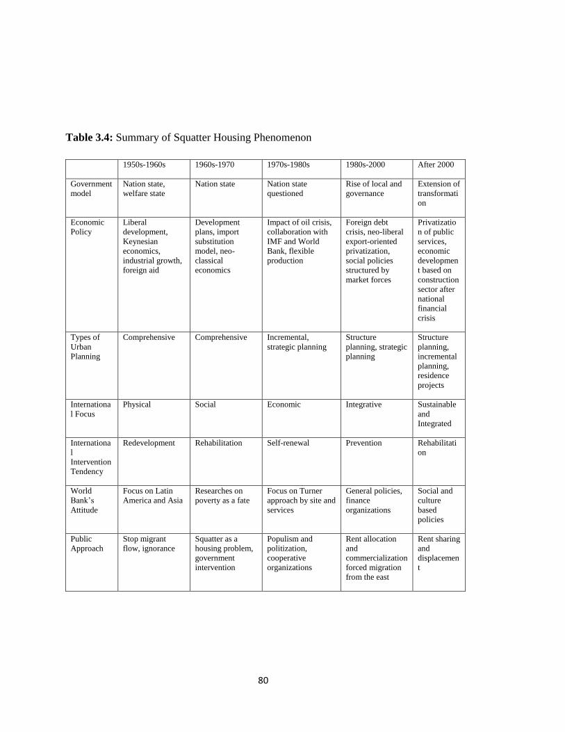
80
Table 3.4: Summary of Squatter Housing Phenomenon
1950s-1960s 1960s-1970 1970s-1980s 1980s-2000 After 2000
Government
model
Nation state,
welfare state
Nation state Nation state
questioned
Rise of local and
governance
Extension of
transformati
on
Economic
Policy
Liberal
development,
Keynesian
economics,
industrial growth,
foreign aid
Development
plans, import
substitution
model, neo-
classical
economics
Impact of oil crisis,
collaboration with
IMF and World
Bank, flexible
production
Foreign debt
crisis, neo-liberal
export-oriented
privatization,
social policies
structured by
market forces
Privatizatio
n of public
services,
economic
developmen
t based on
construction
sector after
national
financial
crisis
Types of
Urban
Planning
Comprehensive Comprehensive Incremental,
strategic planning
Structure
planning, strategic
planning
Structure
planning,
incremental
planning,
residence
projects
Internationa
l Focus
Physical Social Economic Integrative Sustainable
and
Integrated
Internationa
l
Intervention
Tendency
Redevelopment Rehabilitation Self-renewal Prevention Rehabilitati
on
World
Bank‟s
Attitude
Focus on Latin
America and Asia
Researches on
poverty as a fate
Focus on Turner
approach by site and
services
General policies,
finance
organizations
Social and
culture
based
policies
Public
Approach
Stop migrant
flow, ignorance
Squatter as a
housing problem,
government
intervention
Populism and
politization,
cooperative
organizations
Rent allocation
and
commercialization
forced migration
from the east
Rent sharing
and
displacemen
t

81
Table 3.5: Summary of Squatter Housing Laws Enacted in Turkey
Act No Approval Date Target Result
5218 1948 Empowerment of municipality to
undertake improvements in
“gecekondu” areas
Dense squatter zones were reserved for
housing development and the vacant
lands were transferred to municipality
5228 1948 Extension of 5218 throughout the
country and financial credits for
housing
Financial credit provisions helped to
middle-income groups rather than low
income groups
5431 1949 Demolish present squatters and
avoid further construction
Could not be achieved perfectly
6188 1953 Produce land for housing and
legalize present squatters
State owned land was transferred to
municipality and demolitions never
could be carried out fully
775 1966 Improvement, clearance and
prevention of squatter houses
Only 1.3% of squatters could be
cleaned
2805 1983 Preservation and improvement and
demolishment
22 improvement plan areas were
determined by Ankara Municipality
2981 1984 Preservation and improvement “Tapu tahsis belgesi” and title deed
were distributed to squatter owners
3290 1986 Enlargement of illegal housing
concept
Offices and houses transformed from
houses were included in the definition
of illegal housing
5216 2004 Revision of the responsibilities of
metropolitan municipalities to
ensure that services of metropolitan
municipality and HDA are provided
in a planned and efficient way
Metropolitan municipalities misused
their authority by the demolition of
squatter areas that could not been
transformed by market-mechanism.
Areas having constitute risk to life and
the historical areas were also subject to
urban transformation.
5104 2004 HDA and the Metropolitan
Municipality of Ankara are
authorized to improve the physical
structures and environment of
Northern Ankara Entrance.
Displacement, ignorance of the
properties and characteristics of the
locality
6306 2012 Determine the principles, methods
and processes related with
rehabilitation, demolition and
reconstruction under disaster risk
and at other areas to provide
technical, environmental and
zoning plans.
Loss of the local extend in urban
transformation, increase in urban
density and inefficient use of public
land

82
After the synthesis of the main laws and attitudes towards squatter housing in Turkey
there gathered three main points as;
- The main targets and the motivations of the laws could not be satisfied properly,
- The general attitude towards squatter housing problem differentiates in Turkish
practice especially after 1970s,
- The main route of the laws altered with respect to popular needs, attitudes and
political wills,
- There is not any spatial reference in the laws with respect to urban design or
community planning elements enacted to solve squatter housing problem
although, the focus is on physical intervention.

83
CHAPTER 4
URBAN RENEWAL AND TRANSFORMATION EXAMPLES OF SQUATTER
AREAS IN TURKEY
4.1. Dikmen Valley Housing and Environmental Development Project Area
Dikmen Valley is located between two densely populated housing quarters, Çankaya and
Dikmen, which are in Ankara‟s southern urban development zones. The area is
approximately 2,5 km far away from the city center. Çankaya is the most prestigious
district of Ankara, where the presidential residence is located. The area stretches south
along bottom of the valley for approximately 6 km and has a width of 300 m along the
city centre, Kızılay, and reaches the unsettled areas in the south. (P. Türker-Devecigil.
(2010). Urban Transformation Projects as a Model to Transform “gecekondu” Areas in
Turkey: The Example of Dikmen Valley – Ankara)

84
Figure 4.1: Location of Dikmen Valley in Ankara (Türker-Devecigil, 2010: cited in
Metropol İmar, 1994)
The area was invaded by squatter houses until the end of 1980s. The aim of the project is
to totally transform the valley to a recreation area on a city scale, to create a commercial,
cultural and social urban node for the city and to provide housing for squatter housing
people in the project area by using relocation model. (Metropol İmar, 1994; Uzun; 2003
cited in Z.E. Kahraman. (2008). The Relationship Between Squatter Housing
Transformation and Social Integration of Rural Migrants into Urban Life: A Case Study
in Dikmen)

85
Figure 4.2: View of the gececondus in Dikmen Valley; Federico Malusardi and
Giuseppe Occhipinti - University of Rome “La Sapienza”, DPTU Informal Settlements
Upgrading: the Gececondus in Ankara, 39th ISoCaRP Congress 2003, Cairo.
The Ankara Greater Municipality and the Municipality of Çankaya proposed the
Dikmen Valley Project in the master Plan of Ankara in 1989. The valley was included in
the previous plans of Ankara but in the Jansen Plan (1932) it was out of the urban
development area. (Malusardi, 2003)

86
Figure 4.3: The first City Development Plan of Ankara (1932), designed by the architect
Hermann Jansen. Aside, the Proposed Open Space in the “Urban Development
Strategy: Ankara 1970-1990”.(Malusardi,2003)
In the Yucel-Uybadin Plan (1957), the Dikmen Valley was planned to be a green belt
between residential areas. After the 1960s, parks and green areas were gradually
developed within valleys in the city. The valley thought to be designed as a natural
conservation area in all urban development plans since the valley is one of the most
important air circulation corridors and the water basins of Ankara. (Türker-Devecigil,
2010)
However, the Dikmen Valley was left and so became an attractive site for
“gecekondu”s. Piecemeal plans and projects implemented in and around the valley
encouraged illegal buildings. (Malusardi, 2003) The “gecekondu” development process
in the valley started after the 1960s and the number of “gecekondu” units reached 1,916
with nearly 10,000 inhabitants in 20 years (Turker-Devecigil, 2010; cited in Metropol
Imar, 1991).

87
Figure 4.4: The“2025 Master Plan for the Metropolitan Area” (1993). (Malusardi,
2003)
In 1986 the Ankara Greater Municipality prepared a comprehensive plan to develop an
urban park in the valley basin. The name of the project is Dikmen Stream Green Area
Project, which aimed to relocate the “gecekondu” inhabitants to another part of the city
by transforming the valley into an urban park. This project could not be implemented
because of high expropriation costs and oppositions of the “gecekondu” but it was
reconsidered and redesigned as a housing and recreational project in 1989. (Turker-
Devecigil, 2010), (Malusardi, 2003)
To encover the planning, a semi-public company, Metropol Imar A. S., was established
in partnership with the Çankaya Municipality (1990). Many surveys and investigations
were done during the process such as maps, geological reports were done. Moreover;
interviews were conducted with the residents, and five co-operatives were established in
five neighborhoods. (Malusardi, 2003)

88
Since Dikmen Valley has been a physical threshold separating upper-income groups in
the west and lower-income groups in the east, the project also aimed to integrate these
two income groups in a public space area by socio-cultural activities in the valley. The
residential areas were located skirts of the valley in order to allow resettlement of the
squatter housing population and also to moderate-upper income groups by cross-subsidy.
(Metropol İmar, 1991; Türker-Devecigil, 2003; Uzun, 2005). Moreover; commercial
centers, municipal services and car parking facilities were also constructed under the
name of Valley Gates for both as a social infrastructure and also for financial purposes
(Türker-Devecigil, 2005 cited in Kahraman, 2008).
Figure 4.5: Left: Dikmen Valley Development Plan (Malusardi, 2003), The 1991
approved project of the Dikmen Valley (Malusardi, 2003)and main infrastructure: the
Yildiz-Oran Axis the study of the subdivision of the land ownership. (Malusardi, 2003)
Project area covers 158 hectares containing 2300 squatter housings with 9809 residents.
Five implementation zones were identified during that the total population of the area
was increased by 183.50% after the completion of the first and second phases of the
project. (Dündar, 2003) At the end of the meetings, 1080 squatters programmed to be
settled in 500 houses. The squatter housing inhabitants were resettled to temporary

89
small, prefabricated apartments by rent subsidy supported by municipality. (Dündar,
2001; Türker-Devecigil, 2003; cited in Kahraman, 2008)
Different viewpoints produced by different stakeholders that Türker-Devecigil (2010)
explains foru different perspectives to Dikmen Vally project as;
1. as a natural element to be preserved
2. as an invaded natural element to be rescued
3. as an urban area to be rehabilitated
4. as a value to be shared.
The significance is the Dikmen Valley Project is the role of public participation. An
actor scheme was defined for assigning process of the project between local
governments and squatter housing owner‟s face-to-face meetings and decision
committees were programmed that face-to-face meetings took place at the beginning to
provide participation and approval of squatter owners. To organize the community,
housing cooperatives were encouraged to provide integration and communication
between developers and inhabitants. (Metropol İmar, 1992; cited in Kahraman, 2008)

90
Figure 4.6: Implementation zones of the Project (Turker-Devecigil, 2010; adapted from
Metropol İmar, 1991)
After the municipal elections of 1989, the new local administration introduced the
Dikmen Valley Project as the biggest “gecekondu” transformation project of Turkey.
The participants as the project bearers were the Greater Ankara Municipality (GAM),

91
the Çankaya District Municipality (C¸ DM) and Metropol Imar (a public project
management company, whose capital holders were GAM and the district municipalities)
(Turker-Devecigil, 2010; cited in Kuntasal, 1993).
This project can be condemned to be the first public participatory project since a degree
of consensus was established between the squatter owners and local authorities.
However, these participation mechanisms worked at the beginning but could not
continue after the municipal elections of 1994. During the ten years of the
implementation process, the project principles and terms of agreement were altered and
the participatory character of the project was totally lost since the focus was turned into
sharing the profit. (Türker-Devecigil, 2005; cited in Kahraman, 2008)
The right-holders are defined as those who have an average plot size of 300-350 square
metres, and who applied to be legalized before 1985. Any household having these
conditions is granted one new flat. Any plot size greater than the average was
expropriated, and if it was less it was either expropriated or the owner paid for the rest of
the land. Those who were not right holders had to leave the area. The Greater Ankara
Municipality paid for the expropriation and many tenants left the area. (Malusardi,
2003)
In the first 13 years, only two-fifths of the project was completed, many modifications
took place and many legal disputes occurred between the stakeholders. In addition to its
debatable issue, it has both negative, (displacement of low income groups, high
construction rates in the valley, the inadequate analysis for water systems, eco-basins,
river-catchment areas and ecosystem approach, etc.), and positive impacts (participatory
mechanism in urban management, new financial innovations, etc.). (Dundar, 1997;
Gunay, 1993; Sahin, 1996)

92
4.1.1. Evaluation of the Project
4.1.1.1. Strengths
1- The financial model
One of the strengths of the Dikmen Valley model is its self-financing structure providing
minimum financial burden to local governments. Financial costs were met by additional
construction rights and marketable urban uses. Moreover; financial sources are also used
to convince the “gecekondu” owners to take part in the project as shareholders.
2- The participation process
For the Dikmen Valley model, consensus building and trust creation between
“gecekondu” owners and project bearers are the main issues that determine the success
of the project. The participation process in Dikmen Valley was successful in terms of
developing a consensus and the trust compared with many other transformation attempts
that failed. However, it was limited in terms of the participant groups and the degree of
participation. However; in time the participation process decreased especially after the
second local elections.
4.1.1.2. Weaknesses
1) Participation
The main objective of the project was to transform the “gecekondu” houses in the valley
to provide a better quality of life as well as to create and design an urban park as an air
corridor and a green area for the whole city in addition to minimize the risk created by
natural features of the area. In fact; the project had different objectives in various scales.
However, there always occurred confusion and dilemmas in main objectives. The project

93
documents explain that the sole objectives were to preserve the natural characteristics of
the valley by providing a green space for Ankara and to transform ““gecekondu” areas”
by providing a participatory decision-making mechanism. However, the latter has
become the only issue in question during the implementation. (Turker-Devecigil, 2010)
2) Displacement
1480 squatter housing inhabitants were identified as rightholders before the construction
process of the project (Türker-Devecigil, 2003), the number of the rightholders
significantly decreased in later processes. According to the field surveys, 22% of the
title-holders sold their houses in the valley since 1997; in 2002, 37% of all titleholders
rented their houses. In the year 2003, the number of right-holders settled in the valley
decreased to 342 (Türker-Devecigil, 2003; cited in Kahraman, 2008).
Moreover; in the Dikmen Valley, in 1997, the right-holders occupied 49% of the total
social housing units completed (Dündar, 1998). However; in 2003, this ratio decreased
to 39% (Türker-Devecigil, 2003). The second problem encountered in such project areas
is the social polarization created between the residents of the social houses and the
luxury houses. In the first and the second implementation zones, 1047 luxury houses
were built for high-income groups and 882 social houses for squatter owners. At the end;
the squatter owners reflected their discomfort due to the high-rise luxury houses
(Türker-Devecigil, 2005; cited in Kahraman, 2008).

94
Figure 4.7: Bridge of the Valley, (Malusardi, 2003)
3) Legislative Framework
The absence of a clear legislative framework for urban transformation is one of the
weaknesses that resulted in unexpected problems during the implementation of the
Dikmen Valley project. Therefore, the developments that took place in the Dikmen
Valley case have been open to debate in legislative terms and they were mostly used by
the opponents to the project that the “gecekondu” inhabitants and landowners in the
valley started to expect to receive the same development rights for the valley (Metropol
Imar, 1994 cited in Türker-Devecigil, 2005).
4) Social Exclusion
This model produced a potential for developing social inclusion strategies by means of
urban design (such as more common areas, cultural activities, etc. besides the
participation mechanisms. However, the integrative design strategies in spatial terms did

95
not solve the social segregation problem that arises due to the two different income-level
groups using the same space. The process ended up with social exclusion of the low-
income groups and their „voluntary‟ dislocation. (Türker-Devecigil, 2005). This may be
result of the use of luxury integration zone design instead of designing and planning
more moderate and modest integrating land uses.
In sum; Dikmen Valley project can be regarded as successful model in terms sharing the
financial values compared to the previous improvement plan regeneration models.
Moreover; depending on the first phase, public participation was also succeeded in some
level. However, the share targeted the squatter housing owners and disregarded the
tenants (Türker-Devecigil, 2003; cited in Kahraman, 2008). Moreover; high
displacement levels also occurred in Dikmen Valley Project and social integration of the
poor and rich as one of the main purpose of the project did not suceeded. On the other
hand; in deed the problem of squats in Dikmen Valley was erased as a result of all above
discussions.
4.1.2. Morphological Evaluation of the Dikmen Valley Project
For morphological evaluation; implementation zone III is selected since the area has also
non-implemented parts. Based on satellite image and site observations, the project are
was analyzed in terms of three urban morphology theories of figure and ground theory,
linkage theory and place theory.

96
Figure 4.8: Satellite Image of the Morphological Analysis Study drom Dikmen Valley
Project
4.1.2.1. Figure and Ground Analysis
By figure and ground analysis, the relationship between building mass or solid and void
has been investigated that the main urban grain and the spatial order it creates were
identified. From figure and ground analysis, it is observed that the main reference of
order which is the topography of the site has been diminished. Mainly in the south and
partially in the north-west there still exist non-transformed areas that the squatter tissue
fallows the topographical lines which provide an organic order, continuity and
proximity?
In addition to horizontal rhythms of the small squatter structures still exist in the area,
they provide a vertical rhythm. The valley creates a natural enclosure that low storey
squatters do not disrupt the natural silhouette of the valley sue to their height and scale.

97
On the other hand, the majority of the area has been transformed into high-rise blocks
that they dominate the natural silhouette of the valley. Due to geographic and
geomorphological limitations, the blocks located on upper skirts of the valley that the
natural power lines could not be observed any more.
In two-dimension, the new structures do not adopt and reflect the general appearance of
the site. The existing squatters do not encompass a spatial hierarchy. However; the
blocks cannot provide either. The orientation of the building blocks does not express a
spatial system. In other words; without road pattern and other means of communication
such as the green valley system, the order and system of the layout cannot be observed
through figure and ground analysis.
Figure 4.9: Figure and Ground Analysis of Dikmen Valley Project

98
4.1.2.2. Linkage Analysis
By linkage analysis, the dynamics of circulation as generators of urban form; connection
and movement is investigated that two main means of communication is identified in the
area as the roads and the open green axis of the valley. By investigating the solid and
voids with main communication channels, the means of order can be identified.
Although the spatial hierarchy through public space to semi-public space cannot be
identified through figure and ground analysis, the main logic of the spatial hiearachy can
be identified by linkage analysis. The valley basin acts as a green collector and has a role
of public space of the area. On the other hand; the skirts are private zones in broader
scale. However; in block or building scale the means of spatial hierarchy cannot be
identified.
Figure4.10: Linkage Analysis of Dikmen Transformation Project Site

99
The other significant observation in addition to lack of spatial hierarchy is that there is
not any road hierarchy in the area which means that the main communication channels
cannot be clearly identified. On the other hand; the linear green system of valley laying
from north to south has a strong natural reference. In addition; it creates a dominant
communication channel. The roads serving and framing to valley creates an order and
communication system in the north. However; they are sprawled in east and west that
the end of valley, open system and spatial hierarchy is being lost.
4.1.2.3. Place Analysis
By place theory analysis, in addition to basic urban design elements the cultural,
behavioral and human characteristics of the site is investigated. Since the features of
urban form and morphology was investigated by figure–ground and linkage, the focus of
the place analysis is determined as image analysis, the sense of place and the spatial
order.
Firstly, although the traffic junctions exist, there is not a well-defined node in the site.
Due to rehabilitation of the topography, there does not also exist a definite edge in the
sire except the steep upper slopes creating panoramic viewpoints to valley basin. Thirdly
there occur three landmarks in the site that they are social and cultural structures
servicing to whole side in the valley recreational green spine. Fourthly, the valley in
itself creates a clear district observed in a unity. Fifthly and lastly the pedestrian path
lying through the middle of the valley can be regarded as the main path of the site.
In terms of urban design values, it can be observed that the sense of place can be
observed in both transformed blocks and in non-transformed squatter sites squatters
located in the south. Although some parts of the project provides and order and rhythm
with respect to relations they create in themselves and with the natural topography, the
human scale has been lost by transformed quarters. The high-rise blocks detoriate the

100
natural silhouette of the valley basin. However; in the development of star shaped blocks
on the east side of the valley do not produce a spatial order. Furthermore, they netiher
define neither the street nor the topographical lines. On the other hand the blocks located
in the south east of the site, a spatial hierarchy from private to semi-public to public
space can be visualized.
Figure 4.11: Place Analysis of Dikmen Transformation Project Site

101
4.2. Şentepe Urban Transformation Project
Şentepe District is one of the oldest squatter settlements in Ankara, within the borders of
Yenimahalle Municipality. The neighborhoods were densified approximately in 1960‟s.
Şentepe is consist of eleven neighborhoods as; Burç, Barıştepe, Çiğdemtepe, Kayalar,
Kaletepe, Güventepe, Ergenekon, Avcılar, Güzelyaka, Anadolu, and Pamuklar.
Karşıyaka graceyard is located in the north of Şentepe, Yenimahalle in the south,
Demetevler in the west and Keçiören in the east. The neighborhood is approximately 10
km to central core.
Figure 4.12: Location of Şentepe District with respect to Central Area (Image source:
googlemaps.com)

102
In 1952, 66 ha of the Şentepe District were planned as Development Co-operative with a
population capacity of 20580. (Kaba, 1995) However; the emergence of squatter
settlements on the lands of Treasury after 1950s, prevented the implementation
possibility of the co-operatives. In 1968, by the law of 775 which is enacted in 1966;
Şentepe was designated as Squatter Prevention zone and some parts of the district were
nationalized. In 1984, 1/5000 scaled Şentepe Squatter Settlement Development Plan
was approved then by 1986, 1/1000 scaled implementation plans were began to be
approved and be implemented in 1990s.
During the planning analysis period of 1/5000 scaled Development Plan, the population
of Şentepe was calculated as 60.000 by the information taken by neighborhood officers.
On the other hand; 20.000 title deeds had been recorded as distributed in the district.
Kaba (1995) claims that the actual population of the district was about 84.000. Şentepe
covering 580 hectares of the land is planned to be inhabited by 100.000 people in 1990
by Improvement Plans enacted between 1986 and 1990. (Kaba, 1995) Şentepe was
planned as 4 storey apartments with a population density of 300 persons per hectare. On
the other hand, the co-operative land is by 310 persons per ha with 3 to 8 storey
apartments. (Kaba, 1995) However; majority of the area could not be transformed due
to lack of the area‟s financial attraction to investors.

103
Figure 4.13: Tissue of Şentepe District (Source: googlemaps.com)
By improvement plans, the population of the district was planned to be doubled.
However; the social infrastructure facilities, green areas and transportation system was
not planned in a qualified manner. In 2004, the the implementation plans were finished.
Construction right of each title holder parallel to their share registered in their deeds so
the small parcels creating obstacles in apartment construction cause in difficulties for

104
transformation. Furthermore; the transformed parts did not bring economic
attractiveness in the site that a central core could not be developed in the district.
Figure 4.14: The Transformation Process in Şentepe District (Retrieved from;
http://wowturkey.com)
4.2.1. General Information of the Site
Çiğdemtepe Neighborhood is the third stage of Şentepe Urban Transformation Project.
The aim the project is to protect the green areas of the site and increase the attractiveness
of the site in terms of economic, social, and cultural aspects and increase the quality of

105
life. The third stage is located in the north of Şentepe district covering approximately
60ha area.
Figure 4.15: The Third Stage of Urban Transformation Project, Çiğdemtepe
Neighborhood
The neighborhood has a circular shape that there is a ring road which acts as a main
distributor of the district. Since the neighborhood is located on a sloppy hill, by
transformation project some roads are closed. The insufficient green areas are increased.
Furthermore; recreational activities were also supported in trading central area.
The Development Plan was enacted in 1989 and parcellation plan in 1990. Under the
transformation project a neighborhood center is planned which is consisted of;
- a trade and a social center,
- a health center,
- a police station,

106
- a governmental institution,
- a municipal service area,
- enhancement of existing mosque
Figure 4.16: The Development Plan of the 3. Stage of the transformation project (Report
of Şentepe Urban Transformation Project, Yenimahalle Municipality; cited in (İveynat,
2008)

107
There is no any financial support or funding incentives in urban transformation project
that the transformation was designated to be funded by contractors. Both to attract
contractors and preserve the right of share-holders construction rights were increased in
the district. Furthermore, this plan offers free height for constructions by fixing the
construction zone of a parcel which gives the opportunity to create flexible architectural
design in the site. The provision of infrastructure is designated to be services by public
institutions which can be listed as (İveynat; 2008: 127)
- Physical Infrastructure: Local Government, TELEKOM, BEDAŞ, ASKİ and
EGO
- Social Infrastrucutre: MEB, Central Government, Local Government
- Housing and Trade Centers: Contractors
- TV Tower: Cooperation of TV Channels
Figure 4.17: Transformed Apartments in Şentepe (Özdemirli, 2012, p. 222)

108
Table 4.1: Distribution of Land Uses (Report of Şentepe Urban Transformation Project,
Yenimahalle Municipality; cited in İveynat, 2008)
LANDUSE

109
4.2.2. Morphological Evaluation of the Şentepe Urban Transformation Project
By improvement plans as well as the infrastructure and social services, the physical
pattern was also aimed to be rehabilitated. In Yeskep Report (1997) the current layout of
the squatter housing was conceptualized. Moreover; the expected morphological pattern
was also sketched which suggests to provide spatial order. In the conceptualized
diagram, a system of spatial hierarchy, continuity or enclosure could not be offered
except decreasing the number of structures and enlarging the structural scale. Moreover;
the layout produced by layouts did not resembled to the conceptualized proposed urban
pattern
Figure 4.18: The Conceptualized Transformation of Urban Fabric Through
Improvement Plans in Şentepe (YESKEP Report, 1997 Municipality of Yenimahalle)
For morphological evaluation; Çiğdemtepe Neighborhood which is the third stage of
Şentepe Urban Transformation Project is selected since the area has also non-
implemented parts and it has a clear frame of reference. Based on satellite image and site

110
observations, the project are was analyzed in terms of three urban morphology theories
of figure and ground theory, linkage theory and place theory.
4.2.2.1. Figure and Ground Analysis
By figure and ground analysis, the relationship between building mass which is the solid
and void has been investigated that the main urban grain and the spatial order it creates
were identified. From figure and ground analysis, it is observed that the main reference
of order which is the topography of the site has been altered and disrupted by large scale
and scattered solids. However, in the south and east there still exists non-transformed
areas that the squatter tissue follows the topographical lines which provide an organic
order and continuity.
The majority of the area has been transformed into apartments which are scattered and
coincidentally creates spaces. Although; the power lines derived from topography can be
observed through figure and ground analysis there cannot be identified a spatial
hierarchy. The relations between buildings do not display any system that the Gestalt
principles of continuity, proximity, enclosure and similarity cannot be identified. Except
main roads, the structures do not define the street line that the differentiation of public
space and private cannot be read especially in northern quarter of the site.
On the other hand; the squatter belt laying from north to south on the east of the site,
signifies a natural rhythms of topography which also reveals basic Gestalt principles as
continuity, enclosure, proximity and similarity. From squatter tissue the public areas as
the non-habited land which is left as green and the street layout can also be easily
visualized from the solid and void analysis of the site.

111
Figure 4.19: Figure and Ground Analysis from Şentepe Urban Transformation Project
4.2.2.2. Linkage Analysis
By linkage analysis, the main system of circulation, connection and movement is
investigated that two main means of communication is identified in the area as the roads
and the open green belt on the north. The identification of the main connectors or
communication spines of the site do not significantly alter the consequents identified by
figure and ground analysis. However; the public spaces servicing to the site can be more
easily identified by addition to road system to the scheme.
The hierarchy of the communication system as the paths and roads can be identified
through linkage analysis. The ring toad framing the least steep top of the hill defines the

112
main collector road. Furthermore, the vertical roads lying from north to south also feeds
the area as secondary collectors in transformed area. The change in the scale of
development can also be identified by comparing the urban scale of the transformed
quarter of the site non-transformed squatter zone.
In addition to structures; the connectors also enlarged extensively by improvement
plans that the human scale created by organically developed self-help squatter housing
was also hurt. In addition; the linear green system of north skirts of the hill provides a
strong natural reference. Although it creates a linear system of communication in spatial
manner; it could not worked as a public space and means of communication since the
step vacant land has not been rehabilitated. Inside the side there occurs large open green
areas like urban parks, however; they are scattered through the site and do not create any
sense of continuity or order.

113
Figure 4.20: Linkage Analysis from Şentepe Urban Transformation Project
4.2.2.3. Place Analysis
By place theory analysis, in addition to basic urban design elements the cultural,
behavioral and human characteristics of the site is investigated. Since the features of
urban form and morphology was investigated by two preliminary analysis as the figure–
ground and linkage, the focus of the place analysis is determined as image analysis.
Firstly, there is only one node investigated in the site which is at the center of the site
and functioned as a traffic junction rather than a meeting point. Secondly, there exists a
topographic edge at the north of the site defining the northern border of the site with the
steep topography. Thirdly there occur three landmarks in the site that all three of them

114
are mosques. Fourthly the quarter of schools can be regarded as a district and lastly the
ring road is the main path of the area although it is mainly functioned for traffic access.
In terms of urban design values, it can be observed that the sense of place cannot be
observed in transformed and apartmanized blocks whereas it is identable in the eastern
squatter belt. As mentioned, the apartments generally do not define the street except the
fabric of the south-east of the site along the ring road. This results in the loss of harmony
and commitment to place although they can be sensed in the nn-transformed squatter
zone. In other words; it can be said that any form of order did not be considered via
implementation plans in Şentepe district.
Figure 4.21: Place Analysis from Şentepe Urban Transformation Project

115
CHAPTER 5
ANTAKYA BAĞRIYNAIK DISTRICT
Bağrıyanık District is located in the southwestern part of Antakya as a squatter
negihborhood which emerged after 1950s. The area was selected as the main case study
to understand the morphological features of an existinf squatter settlement which has not
been subjected to development pressure yet.
5.1. General Information of Antakya
Antakya is the eastern end of the Mediterrian coastal zone, and the southernmost city of
Turkey. The city is edged by Amik Plain, skirts of Amanos Mountains and Habib-,
Neccar Mountain. The city is tribute by two rivers as Hacı Kürtüş Deresi (Onoplikles),
passing nearby St. Pierre Church & Iron gate and Asi with its ancient name, Orontes;
dividing the city into two parts. The western pats as new city and the eastern part the old
city. The city is mainly divided by Asi River. The eastern part can be called as Old city
and the western is new, developed after 1960s. Old Antakya is located on the strip land
measuring approximately 1 km by 1,5 km between Asi river and Habib-i Neccar
Mountain. The Orontes is the main attribute leading to attract civilizations to the area
throughout the history. (Ataman, 1996)
The population of Antioch was nearly 25.000 when it was established as a large
settlement for Ancient Period. In the 5th
Century A.D. the population of the city was
nearly 200.000 according to the written resources. In Ancient period the population was

116
regarded to be increased to 500.000. After that period the city began to decrease in size
and population. After Sassanid conquest the Roman Empire redeveloped the city in
smaller size.
However, the city decreased till the Ottoman Empire, also in this period did not shine as
much as did in the Ancient times. In 1908 the population was nearly 64.000 mostly as
Muslims; the Christian minority was mainly worked in commercial activities. In 1914
the total population was around 90 500 with a significant ethnic groups of Orthodoxies
(7352) and Gregorian Armenians (4773). (Ataman,1996). The current population is
213296. (TUIK, 2011)
Figure 5.1: Land Use Pattern of Antakya (METU, 2010, Studio Work)

117
5.2.Historical Evolution of City and its Morphology
Antakya region as especially Amik plain was subjected to the conquest of many
civilizations throughout the history due to its moderate climate, efficient agricultural
capacity and being as a node for trade routes.
5.2.1. Early Times
The history of the Antioch region including the Amik plain extends to the Neolithic and
Paleolithic periods. However, the information is limited for that remains since a
systematic survey has not taken place yet. Antioch was founded by Seleucus 1 Nicator
which settled between Silpius (Habib Neccar) Mountain and Orontes (Asi) River in 300
BC. and became Rifaioğlu, Mert Nezih; Şahin Güçhan, Neriman; Larkham, Peter J. a
capital and court-city of east Seleucid Empire after 281 B.C. until the beginning of
Roman Empire period in 64 BC. (Jacquot, 1931; p.218 cited in Rifaioğlu et al., 2010).
After the death of the Great Alexander, (323 B.C.) the large lands of empire was shared
by his generals as Selevkos Nikator was taken the region of Syria and he established
four large cities as; Antiokheia, Selevkos Pieria, Apamea and Laodicea. The two of them
as port cities and the general layout, road system are similar for all. (Ataman, 1996)
The agora of the city was established on the current Craftsmen zone and bus station of
the city; although the building heights are inconsistent and high in some parts; the
archeological remains are thought to be deep in depth son the potential is still exists. The
ancient Antioch was established at the left side of the Orontes flowing to the south, on
an island and some part of the plain. The main route Antioch to the port city Selevekia
Pieria was leaving the city from the existing Municipality Square.
During the establishment period the ethnic structure of the city was heterogenic as the
Jewish population was visible till those periods. (Ataman, 1996). After the conquest of

118
Rome, the city of Antioch was announced to be free to govern itself. This situation
shows the high level of civilization till the conquest. In Roman period Antioch preserved
its importance to be the largest city of the northern west region of Syria and became the
capital of the Empire‟ s Syrian province. The earliest development activities were the
building of a palace and circus on the Orontes River Island in 67 BC.
In the period of Augustus, a large development program took place as; enlargement of
roads, construction of baths, theatre and stadium was accomplished. Moreover; the
construction of colonaid road and monumental structures on the intersections of the
main routes are the significant elements of that period. Antioch also experienced at least
ten large earthquakes in 5th
Century B.C. but the city was repaired every time.
Figure 5.2: Plans of Ancient Antioch (Ataman, 1996)

119
The underground heritage layers are very deep in the plain areas due to the alluvial fill.
However; in morphological pattern of Antioch some traces from the ancient road system
can be read in the current road pattern. The city was designed as a Hippodamian plan
with straight streets intersecting at right angles, applied by the architect Xenarius. The
streets roughly parallel to the Orontes River were laid out 112 m. apart, and the streets
intersecting at rights angles to the those streets were 56 m. apart. The 2:1 ratio in the
street layout is typical in Seleucid cities in Syria and Mesopotamia. (Demir, 1996;
Pinon, 2004 cited in Rifaioğlu et. al, 2010) The design and orientation of the streets were
designed to minimize the microclimatic effects of hot summers. (Ataman, 1996)
The grid system of Orhanlı & Meydan neighborhoods and on the borders of cultivation
gardens and agricultural land subdivisions are thought to be morphological features
readable in present tissue of the city. (Ataman, 1996) Moreover; the Aleppo-Harbiye
road which is the main traffic axis which both separates the historic core into two areas
and – according to many sources (Downey, 1963; Demir, 1996; Pinnon, 2004, cited in
Rifaioğlu et. al, 2010) its origin is as a Roman colonnaded street.
5.2.2. The Byzantium and Islamic Period
Antioch had a great role during the emergence period of Christianity. St Petros worked
there as a patriarch for 7 years and 10 church meetings were organized during the period
of 252-380 A.D. After the Sassanid Conquest the city began to decrease. The Byzantine
emperor Justinianos rebuilt the city in 538 A.D. in a smaller scale. During 638-969 A.D.
the city was subjected to Arab conquest but regained again by Byzantium and become
an end city of Byzantine. In 1084 A.D. it was invaded by Mosul shah but invaded by the
Crusaders in 1098 A.D and become an earldom for 170 years. In that period Antioch
revitalized again and in 1268 A.D. it was added to Ottoman Empire by Yavuz Sultan
Selim and become a sancak under Halep Province. (Ataman,1996).

120
Figure 5.3: Map of Antioch in early 20th century (Retrieved from;
http://www.google.com.tr/imgres?sa=X&biw=1517&bih=692&tbm=isch&tbnid=QkJX
bdSccoOyMM:&imgrefurl=http://www.lib.utexas.edu/maps/historical/history_middle_e
ast.html%3Fp%3Dprint&docid=knZyQhpfy7ow0M&imgurl=http://www.lib.utexas.edu/
maps/historical/antioch_1912.jpg&w=1171&h=798&ei=sSmpUsyuJPOT0QX-
0IDQDA&zoom=1)
The organic pattern of the Islamic city did not degenerate the tissue of ancient times
totally since the Ottomans prefer to locate vacant land on the east side of the old ancient
city. However; the growth and expansion then erased the ancient pattern. The traces of
Ottoman period in urban pattern are visible in the southern rehion of Orontes except
some partial interventions which took place in French period. Moreover; some
individual structures of 19th
Century Ottoman period have survived in the historical
urban quarter. In the Ottoman Period the grid urban pattern became more organic in

121
form. Mosques, caravansaries and the Saray Avenue, parallel to Orontes River, were
built which still persist in the current urban form.
5.2.3. French and Republican Period
After WWI the city experienced the French mandate that this period also gave
significant value to the morphological character of the city. The main circular of the city,
radiating roads and the axis of the old district, which is called the Kurtuluş Street were
emerged after French mandate from the colonnaded street. Antakya museum, schools,
hotels, cinema were built at this period.
Some elements of the earlier period persisted as the agora site lies in what is still the
traditional commercial district in today‟s city (Downey, 1963; Demir, 1996 cited in ).
According to Bouchier (1921; p.5) the names of the quarters were Rhodion (likely rose
gardens) and Hereclea. Today, one of the quarter names of the historic core is “Rose
Gardens”, located to its north-east. (Rifaioğlu et. al, 2010) The new road system affected
the quarters of the city accessibility that urban growth concentrated along the radial
roads.

122
Figure 5.4: Map of Antakya in 1931 (Retrieved from; http://mehmet-
urbanplanning.blogspot.com.tr/2009/12/antakya-tarihi-kent-dokusu-koruma.html)
5.2.4. Present Morphology of the City
The morphological pattern of Antakya can be analysed in two sub-city areas by the Asi
River. The western part of the city has been formed since the mid-nineteenth century. It
is linked to the eastern part across the river by seven vehicular and pedestrian bridges.
The western part has main road access to the İskenderun and Samadağ. Additionally, the
eastern part contains both the historic urban core of the city known as “Old Antakya”

123
and the new areas, developed especially after the first quarter of the twentieth century. It
has road access to Reyhanlı, Aleppo and Harbiye. (Riafaioglu et al., 2010)
The urban morphology of the western part is characterized by the baroque layout of
circular main square and radial roads. The inner partitions of the western parts are in
forms of distorted grid system which reveals a high level of accessibility and order. The
eastern part is a linear corridor between the Habib-i Neccar Mountain and the river. The
central quarter of the eastern part of the city has the characteristic organic layout of
medieval Islamic City. In the skirts of mountain till the sharp slopes, a squatter belt lays
out with different morphological characteristics than the historical quarter. In the south
of the eastern part of the city, on Harbiye road, new developments and transformed areas
can be observed.
The current analysis on the historic urban street pattern shows that there is a persistence
of the grid Hellenistic street pattern in the north-east of the historic urban core in 112 m.
x 58 m (Sauvaget, 1935; Downey, 1961; Pinon, 2004 cited in Riafaioglu et al., 2010) in
Orhanlı vicinity. The historical tissue of residential areas is characterized by cul-de-sac
roads which creates a labyrinth system of roads. The ancient agora was observed at
present as the grand covered bazaar area which is called “Uzun Çarşı” resembles with
Ottoman Grand Bazaars like “Kapalıçarşı”.

124
Figure 5.5: The urban pattern of “Uzun Çarşı” during French Mandate Period
(ICOMOS, 2010)
The eastern part of the city has higher building density ratios with respect to west due to
traditional character it has and the limited scape can be sedentarized. However; in the
western part the difference between urban and rural diminished that the morphological
pattern has become a more fringed layout. However; the connectivity is high due to
radial system and the concentrating rings feeding them. The case study area is located in
the southern part of the squatter belt. The area was very close to Central Square linked
with a curvilinear road. The morphological layout of the district is harmonized with
topographic and reflects its features.

125
Figure 5.6: The Urban Pattern of Antakya

126
5.3. Morphological Typology of Antakya
Antakya is characterized as a melting pot of different cultures. The richness in cultural
mosaic is also visible in the morphological mosaic of the city similarly. In other words;
there can be defined different patterns having different characteristics functioned by
different uses of commercial and residential activity. Twelve different typologies of
pattern and use can be identified in Antakya which can be defined as;
Irregular parcel development: The pattern is characterized by individual developments
having an irregular, distort-grid pattern. The development can be legal or illegal in terms
of construction. However; the land is officially owned by user.
Regular parcel development: The pattern is characterized by regular parcel development.
The land is officially owned and parcelized by development plans. The fabric is
produced by small constructors‟ in different environmental and structural quality which
are generally medium or high.
Co-operative development: Those areas by developed through housing co-operatives
after 1980s. The pattern of co-operative quarters is distinct from the general layout since
the structures are not linked to street layout. The hierarchy of private, semi-public and
public space can be observed in co-operative districts.
Row-house type development: The development is characterized by detached row
houses and one storey retail services. This type of urban pattern produces a dense and
regular morphology as well as housing facility to medium income families.
Luxury parcel development: The pattern is characterized by regular and standardized
apartment development along or around the main roads. Those patterns are used as
residential areas of upper income groups of Antakya. Those patterns are generally close
or directly linked to central core.

127
Local parcel development: The local parcel development resembles or irregular parcel
development in terms of figure ground analysis. However; they produce a more
traditional and local spatial organization in and around the house like outdoor stairs,
small courtyards and flat green roofs.
Historical area: The historical are is located at the central part of the eastern city. The
urban pattern has an organic and Islamic layout.
Squatter development: The zone is emerged as a belt between the historical precinct and
the mountain of Habib-i Neccar. The belt is located on uncontrolled land squeezed
between historical and natural conservation sites. The land is generally owned by
municipality, treasury or Waqf land. In some neighborhoods the private ownerships can
also be observed gained by distribution of title-deeds during 1980s and 1990s. The
squatter belt has an organic lay out having some values of the traditional quarter like the
court-yards and front-yards.
Gated Communities: Gated communities are a new phenomenon in terms of land use
and structural typology in Aktakya. The new gated enclave in the forest area began to be
constructed in 2010 as luxury villas. The gated community is very close to study area as
located in the south of Bağrıyanık district.
Workman house development: Those or low-density one or two storey irregular houses
that the structures densify along the main streets and scattered through the countryside.
Those pattern generally functioned as small production units and housing of workers.
Low density fringe development: This type of pattern is produced by urban sprawl that
they are neither urban nor rural tissues. The pattern is used as the quarters of blue-collar
workers and marginal sector employees
Semi-rural development: Those are more rural settlements rather than exposing the
urban pattern and functions. However; they are linked to city by radial roads and the

128
inhabitants generally work in small jobs in Antakya. However; agricultural activity also
continues that the urban morphology is very similar to the morphology of rural villages
around Antakya. However; those are more scattered and sprawled.
Figure 5.7: Urban Pattern Analysis of Antakya (Personal Drawing)
The case study area is located in the southern part of the squatter development
morphological type. The site is also neighbor to other morphological types exist in
Antakya such as; regular parcel development and gated community. From different
types of morphology of present urban fabric of Antakya, 10 different points are picked
up and analyzed in terms of urban fabric including the case study area which is marked
as point E.

129
Table 5.1: Examples of Urban Patterns from Antakya

130
Table 5.2: Examples of Urban Patterns from Antakya (Continued)

131
5.4. Morphological Analysis of the Transformation Projects in Antakya
In morphological typology analysis, two urban transformation projects also have been
identified by numbers as “Area 1” and “Area 2”. The point A is the urban
redevelopment is produced by the collaboration of HDA and Antakya Municipality. The
area is located at the periphery of Antakya that before redevelopment very low density
fringe development was existed on the site. In 2008, construction of 959 houses for
middle and low income groups were finished. The point B is the urban transformation
area developed by the urban development plan of Sümerler District in 1990s.
By development plan of Antakya Central Area 1/1000 scaled Development Plan, the
quarter is planned by residential function by 1.3 FAR (Floor Area Ratio) rate and 21.50
meters maximum building height for Area 1.
Figure 5.8: Development Right Status of Area 1 (Retrieved from;
http://ebldy.antakya.bel.tr:81/imardurumu/)

132
By development plan of Sümerler Vicinity 1/1000 scaled Development Plan, the quarter
is planned by residential function. The developments rights differ in the area differ from
5 storey buildings to 7 storeys along the Harbiye Road. The illegal structures in the site
are planned as green areas or 2 storeys residential.
Figure 5.9: Development Right Status of Area 2 (Retrieved from;
http://ebldy.antakya.bel.tr:81/imardurumu/)
In terms of morphological analysis, it can be observed that by redevelopment of Area 1,
healthier structures were built in the area however; the sense of place was reduced.
Firstly the building heights do not suit to the low-storey and low density structure of the
peripheral area. Secondly the horizontal rhythm and variety were also lost.
The authorized buildings around the area create richness of morphological values by
spatial hierarchy of semi-private and semi-public areas, variety of spaces, structures in

133
human scale. Moreover; they contain socio-spatial values of Antakya houses by green
hose terraces. Furthermore; the variety of spaces are also eradicated by the monotonous
repetitions of the same value. Although; green open areas were planned including a
square they are fragmented and discontinuous.
Figure 5.10: Morphological analysis of “Area 1” from Antakya (Personal Drawing)
By morphological analysis of “Area 2” a typical development pattern via development
or improvement plans can be visualized. The area is selected from high-income
residential area linearly developed along the Harbiye Road. The development was
emerged via small scale constructors that only the two sides of the road was transformed
and the outer parts remained as one or two storey small apartments or houses. The other
weakness in terms of urban morphology is the insufficiency of enclosure.
The deterioration of human scale, variety and cultural typologies such as green roofs is
also visible in the transformation of “Area B”. Moreover; due to many changes in

134
development right, the vertical rhythm in both sides of the roads has been destructed that
the variety of heights of buildings from three to seven. However; the positive aspect of
urban transformation site is the prevention of the street line. The apartments located with
fixed intervals by set of the distances of front yards and side yards that it also creates a
spatial hierarchy of private space- semi-private space (yard) and the public space
(street).
The other disparity observed in the “Area B” is the extreme variety of the facades that
there is not any harmony between the openings such as windows. Moreover; the
materials, styles and power lines of facades of the apartments do not give reference to
each other.
Figure 5.11: Morphological analysis of “Area 2” from Antakya (Personal Drawing)

135
5.5. General Information of the Case Study Area
The district is located on the southwestern part of Antakya at the end of the squatter belt
on the top of a hill. A long squatter belt emerged in the city due to the state or Waqf land
between two conservation sites as the Habib-i Neccar Natural Conservation Area and the
urban historical quarter. Due to above mentioned reasons the control of the area is weak.
The site is a special case that it is topographically segregated from the other regions of
the city and largely situated on 2-B land in addition to small lands of treasury and
municipality.
Figure 5.12: Case Study Area in the City (Personal Archieve)
Bağrıyanık Neighborhood is located on a ridge, expanding from the Mountain Habib-i
Neccar. Before the 1950s the area was covered by forest except some steep sides. In the
neighborhood there are nice viewpoints on the terraces of the Mountain. Some parts of
Bağrıyanık are so steep that it is not appropriate to settle. There are two valleys,

136
surrounding the neighborhood; the first one is formed by Akakir River while the second
is a dried waterway. Both create natural wind corridors for not only the neighborhood
but also the whole city. Nevertheless; some structures were built into the valleys, which
causes an increase in the flood risks as well as earthquake risks
Figure 5.13: Land Use Analysis of Bağrıyanık District (Personal Drawing)
The dominant use of the area is residential that only a few small neighborhood markets
are located in the site. A technical high school and hospital is located on the north of
Bağrıyanık neighborhood. In addition to natural edges, the quarter is hidden by the large
military zone. Bağrıyanık is a collectively formed neighborhood. Around this area,
different income groups are living. As the neighborhood is close to high income
residential area and there is a link with an arterial street; however, as mentioned above

137
there is no visual and social interaction between these two different areas. Moreover,
near forest land there are newly built gated communities.
Figure 5.14: High and Middle Income Residential Areas close to Case Study Area
(Personal Archieve)
Technical infrastructure level of the neighborhood is limited with the provision of water
and electricity but one of the arterial paths is insufficient to meet the demand. Antakya is
on the first degree earthquake zone. Even though, all urban facilities have a certain level
of risk associated with various threats, Bağrıyanık Neighborhood has relatively less risks
than the other parts of Antakya since it is located on a hill, geologically safer for
earthquakes. On the other hand, some houses were built on the floodplain, which is
vulnerable to disasters. Additionally, there are houses located on risk area in terms of
land sliding. The squatters, located inside the valleys are mostly empty; probably as a
result of past experiences of flood. Overall, physical infrastructure is weak in this area.

138
Figure 5.15: Low quality commercial and residential uses in the neighborhood
(Personal Archive)
As Bağrıyanık Neighborhood is close to the city center so the urban amenities are within
walkable distance for the inhabitants of the area. In a 500 m diameter; the neighborhood,
adopted as a walkable distance even for children; a university, hospital and schools are
accessible from the neighborhood. There is a primary school in Havuzlar Neighborhood,
however, the school is not accessible for children due to the topographic barriers since
they have to walk down a steep hill and climb again.

139
Figure 5.16: Topographical features of the district (Personal Archive)
The general profile of the inhabitants can be described as urban poor with low education
level, high household size and irregular marginal jobs. Majority of the inhabitants are
benefited from the state charity funds. The majority of the population in Bağrıyanık
Neighborhood has not got a regular job and some work for temporary or unskilled jobs
in the industrial areas, far from their houses. Thereby, integration with the city center
and urban life is a serious problem for the inhabitants. Although the settlement area is
segregated segregation from its surroundings and poor living conditions but a slum
culture has not been emerged, which is a positive aspect of the neighborhood.
Accordingly, there is not a security problem that the neighborhood is safe. Additionally,
social relations affect the feelings of security. As the social relations are close in the
neighborhood and the inhabitants are close relatives or friends the sense of security is
still high.

140
5.6. Morphological Features of the Case Study Area
The area has lower density with respect to surrounding by a population density of 100-
200 persons per hectare. This is the result of both topographic obstacles and one storey
squatter housing fabric. From the figure and ground analysis, it can be seen that the
layout of the buildings is harmonized with the lines of topography. The structures are
dense in more habitable areas and vacant in high slopes. Moreover; the whole quarter
has a low accessibility due to topographic obstacles and few public transport services.
Due to its physically segregated situation as being on a steep hill top; the higher part of
the district is deprived of urban amenities. Although, the road system is highly
permeable due to its harmony with topography, a road hierarchy is lack in both lower
and upper part of the district. An organic pattern which gives reference to topographical
lines is the characteristic feature of the urban pattern.

141
Figure 5.17: Urban Pattern of the Case Study Area and Close Surrounding (Personal
Drawing)

142
Based on satellite image and site observations, the project are was analyzed in terms of
three urban morphology theories of figure and ground theory, linkage theory and place
theory.
5.6.1. Figure and Ground Analysis
By figure and ground analysis, the relationship between building mass which is the solid
and void has been investigated that the main urban grain and the spatial order it creates
were identified. From figure and ground analysis, it is observed that the main reference
of order which is the topography of the site that the squatter tissue fallows the
topographical lines which provides an organic order and continuity. Even though there is
not a planned or provided public space like a defined square or urban park, semi-public
or semi-private spaces, formed between the houses in the accessible parts of the
neighborhood are used as public space.
Figure 5.18: Figure and Ground Analysis of the Bağrıyanık District (Personal Drawing)

143
The spatial hierarchy can be observed through solid and voids that there exist a complex
but systematic spatial system by interacting spaces between buildings. The voids
between the structures are functioned as semi-public and semi-private spaces. Since the
buildings follows the topographical, they do not define the street line is all parts.
However; the walls and sheds of the gardens define the street line precisely. At the
center of the neighborhood a clear opening as a distorted round square can also be
observed through figure and ground analysis. The inhabitants do not have any property
right that this affects the morphology of the site. Inside the blocks, the houses share the
same courtyards and gardens which create a relational integration.
5.6.2. Linkage Analysis of the Site
By linkage analysis, the main system of circulation, connection and movement is
investigated that two main means of communication is identified in the area as the roads
and the open green system providing a linear communication link. The main connectors
or communication spines of the site can be also perceived from solid and voids. Since
the area has an organic tissue, there is not a precise spatial hierarchy of road network.
Besides due to topographic obstacles, the area is naturally pedestrian friendly. The roads
were organically evolved by benefiting from the topographical system that the main
spine follows the contour line of the hill.
The area has low accessibility due to topographic obstacles and limited public transport
services. As it is a physically isolated area, developed on the top of the steep hill; the
higher part of the neighborhood is deprived of urban amenities. Although, the road
system is highly connected due to its harmony with the topography, a road hierarchy has
not been structured in both lower and upper parts of the neighborhood. However; there
also exist vertical roads, which are generally composed of stairs serving only to

144
pedestrians by climbing the hill. Those paths are narrow opening creating access and
shortcuts between the blocks.
In addition; there exist green continuous linear areas that they also functioned as paths as
well as shared gardens. In other words; they are semi-private connectors providing
access from public roads to structures. Although some parts are steep, the open areas are
generally rehabilitated and can be used properly by inhabitants by help of stairs or small
terraces.
Figure 5.19: Linkage Analysis of Bağrıyanık District (Personal Drawing)

145
5.6.3. Place Analysis
By place theory analysis, in addition to basic urban design elements the cultural,
behavioral and human characteristics of the site is investigated. Since the features of
urban form and morphology was investigated by two preliminary analysis as the figure–
ground and linkage, the focus of the place analysis is determined as image analysis,
gestalt analysis and identity.
Firstly, there is one major and one minor node in the site. The main node is located in
the middle of the neighborhood defined by structures walls and natural elements. The
second node is located in the northern side of the main one used for daily activities by
woman and children. Secondly there exist clear topographic edges at the north and south
of the site defining the northern border of the site with the steep topography. Thirdly
there occurs only one landmark as a part of the node which is the tandır used by women
collectively in the area. Fourthly the site is divided in to districts which define the urban
blocks as well. Each blocks have a socio-spatial organization in itself that the open green
areas in the middle used collectively by the inhabitants of the district. Lastly, there are
many paths including dead-end and ramparts. However; the main path of the site is the
curvilinear road providing access to main road.

146
Figure 5.20: Place Analysis of Bagriyanik District (Personal Drawing)

147
Figure 5.21: Main node of the neighborhood (Personal Archive)
In terms of basic design principles of Gestalt Law, the site has a high level of order. The
forms of the structures both unveil similarity and variety that although they are different
as parts they can bring out a unity. There exists a high level of continuity at the same
time that a curvilinear rhythm derived from the topography can be observed in the site.
The roads and paths have a high level of connectivity that either by houses or by walls or
gardens, the street line can be easily followed in the site.
In addition to the continuity of roads, open green areas and structures, there also exist
continuity in vertical green system of green roofs which is a traditional element of
houses in Antakya. The scale is appropriate to human in the site that the houses have
floor areas ranging from 100 m2 to 150 m2 that they are one or storey buildings.

148
Although the density is low, there exists proximity between structures which defines
usable spaces between the buildings.
Figure 5.22: Gestalt Analysis of Bağrıyanık District (Personal Drawing)
Lastly, in Bağrıyanık case study area the cultural elements expressing character and
identity are also investigated. The definite edges of the site creates habitable piece of
lands that it creates compact parts of settlement in the neighborhood. Since there is not a
parceling implementation or ownership right, there exist a variety of semi-public and
semi-private spaces used as gardens or agricultural purposes collectively. In other
words; it can be said that the physical limitations creates a life in both physical and
cultural urban spaces in the district.

149
Figure 5.23: Socializing nodes of “Tandır” and contuinty of organic roads (Personal
Archieve)
Moreover; on the corners of roads, scattered in the neighborhood, there are “tandır-
tandoors”, used as a shared cooking area. These corners help the socialization of women
that the largest tandoor is located in the main node of the site that it makes the area a
communication and meeting place mainly for women and children. By the green roofs
created by vines, the dynamic use of place and high level of spatial hierarchy,
Bağrıyanık district reveals a strong sense of place as well of spatial identity by place
analysis.

150
Figure 5.24: Analysis of Character and Identity of Bağrıyanık District (Personal
Drawing)

151
CHAPTER 6
CONCLUSION
This chapter concludes the research firstly by summing up the scope and content of the
research. Then, it states expected benefits and constraints of the research. Finally, it
makes some recommendations to improve the urban transformation implementations in
squatter areas.
6.1. Concluding Remarks
Change is a part of urban areas including the man-made ones and the nature based
effects. Thus, urban transformation has very early roots since ancient civilizations.
However; after industrial revolution, change and transformations in urban areas
accelerated. In Turkish case, squatter housing problem emerged after World War II with
mass migrations from rural to large cities. From ignorance to acceptance, different
approaches constructed to solve mainly physical and secondly social problems of
squatter settlements. In terms of implementation two main models were created firstly,
large scale redevelopment projects conducted by collaboration of governmental bodies
and private enterprise. Secondly partial implementation plans created through partial
plans which increased density implemented by small contractors.
Urban transformation conducted through implementation plans are generally criticized
since they have insufficient impact in terms of social welfare but concentrated in
physical space. Those plans generally require increasing density to attract contractors to

152
invest the area. To do this, provision of social services and green areas generally became
under sufficient standards. On the other hand, the physical quality of the buildings were
increased and transformed into apartments.
Since they are conducted by local and central governments, large scale redevelopment
plans may involve more contribution in terms of social services and rights. Those
projects can involve organization of the community and public participation as well as
physical upgrade of housing by public or cross-subsidies. However, for both models
deficiencies of the social side of the projects including displacement has been discussed
in literature. Urban transformation projects in Turkey are generally evaluated as one-
sided projects having physical focus.
Urban design is not limited to investigation of urban physical space apart from social,
cultural and economic dynamics. Thus, the mere focus of urban transformation projects
is not thought to be handled in physical side. Moreover, it can be discussed that urban
transformation creates better residential units in terms of quality. However; the quality
of urban spaces cannot be measured by the quality of residents. Under the light of above
mentioned reasons, in this study, the main aim is to evaluate the morphological features
of space produced by urban transformation projects in Turkey. Accordingly the
hypothesis of the study is “Urban transformation do not creates better quality of urban
spaces?” Related to the main question and hypothesis, different sub-questions are also
revealed as;
- “The socio-spatial well-being of communities can be sustained through urban
transformation?”
- “What are the morphological features of urban environments created through
improvement plans and large scale redevelopment projects”.

153
In order to define the quality of urban spaces produced by urban transformation projects,
two control cases and one main case study selected. The two control case studies are
picked from well-known urban transformation projects implementing in Turkey which
are Dikmen Valley Urban Transformation Project and Şentepe Urban Transformation
Project. The two control cases are selected from two major urban transformation
approaches conducted in Turkey. Dikmen Valley projects can be seen as a characteristic
example of large scale urban redevelopment project model and Şentepe Transformation
Project is an example of urban transformation via implementation plans. The main case
is selected from a squatter housing area, in which a distinct development pressure did
not take place from Antakya, Bağrıyanık District.
The main case study is selected since it includes features of squatter housing areas
including ownership, topography, quality, socio-economic profile and amenities.
However; any ownership right did not give or promised to inhabitants. Furthermore,
development pressure of private sector did not take place as well. Thus, the use value of
squatter housing increased in the case study area that urban morphology was also shaped
related to it rather than property relations. The case study and two control case study
areas are evaluated by a success criteria table by referring the development models, main
features and morphological values they have.
In terms of data collection of the study, the redevelopment plans, projects, protocols and
reports of transformation projects; analysis, articles, theses, satellite images, direct
observations and physical artifacts are collected as a multi-aspect approach. In addition,
as mentioned, multiple case study method is used in order to compare the morphology of
transformed areas with squatter settlements. The main arguments and analysis conducted
in the study was rooted in empirical studies and observations.
154
In the analysis of urban form as the first part of the study, the description and content of
urban form, its evolution by change in settlement needs and the factors shaping urban
form is discussed. Firstly, the main elements affecting urban form are evaluated from
literature research. Urban form is not just corresponded as the shape of urban space but
also the potential level of social interaction is observed through the morphological
features.
In terms of literature research, firstly the evolutionary development trends of urban
forms are discussed from the Classical Times, Medieval Times, Renaissance & Baroque
in terms of main morphological features. Afterwards, industrial city, the effect of
modernism and the new urbanism trend in the post-modern period are discussed. Those
features produced from the literature research in terms of evolutionary process of urban
form are used as an input indicator in analysis of morphological evolution of the main
case study era. Then the elements affecting and reshaping urban form is discussed in
order to understand what shapes the physical urban space both in terms of existing urban
pattern and in terms of urban regeneration process.
After a general examine the factors, different types of urban form is evaluated that those
findings are used in evaluating the morphological features of the control cases and the
main case study area.
Then as the main indicator of the case study analysis, urban morphology theories are
investigated. As a result, the main urban design indicators evaluated by figure - ground
theory, linkage theory and place theory are analyzed. Afterwards, social aspects of urban
morphology are discussed. The role of urban form in social life, spatial hierarchy
including public space, semi-public space, semi-private space and private space are
discussed.
At the end of this part of the study, the regenerative role of community design under
urban design criteria is discussed since the case studies of this study covers the urban

155
transformation process and results of squatter neighborhoods. In the next part of the
study, to focus of the study is moved to squatter settlements and the process of squatter
housing in Turkey parallel to the main aim of the study and hypothesis.
In the second part, which is the third chapter of study, firstly the definition of squatter
housing problem has been discussed under major approaches. Since squatter housing is a
world-wide phenomenon in many developing countries, the different views in terms of
the main forces under the emergence of squatter housing is discussed. As a result,
mainly approaches of Turner and Burgess who are the main contributors to squatter
housing phenomenon in developing countries are discussed. Then the other approaches
are evaluated including the Adam‟s views.
The main point of the evaluation of those views is to understand the different driving
forces in the emergence and development process of squatter housing by rural
immigrants. Turner‟s approach mainly focuses on the use value of a squatter dwelling.
The consolidation attempt of the dweller is also valid in different degrees Furthermore;
Burgess puts a different side of the squatter housing by emphasizing the economic side
of the squatter phenomenon. Parallel to Burgess, Adam also emphasize the economic
value including production side. Afterwards by the definition of actors and processes the
differentiation of ““gecekondu”” phenomenon from the others types of squatter
phenomenon is acquired.
Then the focus of the study is moved to the evolution of squatter housing in Turkey
beginning from 1950s till present. In addition to evolutionary process, different
intervention policies towards squatter housing in throughout the world are discussed.
Afterwards, by narrowing down the topic, the intervention types to ““gecekondu””
problem in Turkey are investigated. At the end of this part of the study, the legal frame
as the main enacted laws in order to solve the “gecekondu” problem in Turkey are
discussed. In the synthesis tables it is also seen that the main targets of the laws
156
generally could not be achieved and those laws do not have a spatial reference in terms
of urban design or community planning. This outcome has also become an important
concern during the evolution of main and control case study areas with respect to urban
design criteria.
In the fourth chapter of the study, the control case studies have been evaluated. Firstly
the general features of Dikmen Valley Urban transformation model which constitutes an
example to large-scale urban transformation projects are explained. Then the aims,
plans, stages, major strengths and weaknesses of the project is evaluated. Afterwards,
the morphological analysis acquired from literature review has been conducted for
Dikmen Valley case study area. Afterwards, the general features, aims, and concept of
Şentepe Urban Transformation Project which is an example of transformation areas by
implementation plans have been discussed. Then, the morphological analysis of the case
study area was conducted.
In the fifth chapter of the study, the main case study has been evaluated as Antakya
Bağrıyanık District. In this part of the study, firstly the main features of Antakya and
historical evolution of the morphology of the city is discussed. Then, morphological
typologies in Antakya were evaluated including the case study area. Afterwards, the
morphological analysis of the urban transformation projects implemented in Antakya
has been evaluated. At the end of the chapter, the morphological analysis of Bağrıyanık
District including urban design values has been discussed.
The main evolution in terms of urban design criteria is conducted through three urban
morphology theories in two control case study area and in the main case study area
which are;
- Figure and Ground Theory
- Linkage Theory

157
- Place Theory
By figure and theory the spatial organization of space in two dimensional view has been
observed by investigating the relationship between solids and voids. The spatial
hierarchy from public space, semi-public space, semi-private space to private space was
also acquired in case study areas. In terms of Gestalt laws, enclosure, similarity and
continuity can also be observed. Furthermore; the main references of order in terms of
nature and power lines as well as the properties of rhythm can be observed via figure
and ground analysis.
As the second important indicator of the evaluation of urban design criteria in case study
areas, linkage theory was assessed. By linkage theory the main communication lines,
axes and connectors can be observed in urban space in two dimensional manner. The
road system and hierarchy, roles of open green areas as collectors and continuity of
paths and green areas are evaluated by linkage theory analysis.
As the third aspect of urban morphology analysis, place analysis is conducted in three
main case study areas. As well as the image analysis of Lynch investigated empirically
in the sites, the other urban design elements, social and cultural clues are investigated.
The sense of place, order, silhouette, rhythm and Gestalt elements are analyzed under
place analysis in Dikmen, Şentepe and Bağrıyanık sites respectively.
In addition since Bağrıyanık district is the main case study area, a more detailed analysis
in terms of urban design elements are conducted. Firstly, the detailed urban design
criteria mainly produced through Gestalt Laws are discussed. Then the cultural elements
which contribute to sense of place are also discussed via sketch analysis of Bağrıyanık
District.
Furthermore, since Antakya is the main case study area, and the analysis of two main
regeneration approaches are contextually different, the two examples of urban

158
transformation sites in Antakya are also investigated which are urban transformation
areas via improvement plans and large scale public redevelopment. By three
dimensional sketch analyses, the differences between the illegal housing tissue and the
transformed areas were analyzed in terms of urban design elements as rhythm,
continuity, enclosure, variety, sense of place and cultural symbols. It is also observed
that the spatial quality produced by improved plans and large-scale redevelopment
projects produce low quality of urban spaces with respect to urban design criteria,
although they develop better quality of buildings.

159
Table 6.1: Summary of the Morphological Analysis

160
The main arguments defined in this study by urban morphology analysis are synthesized
and summarized in Table 6.1. Firstly, three main case study areas are abstracted and
commercialized in term of spatial organization and main functions including central
core, green areas, transformed area, squatter area and social services. Since Bağrıyanık
District has not been transformed yet, there is not a social and physical infrastructure
area in the site. On the other hand, there exist social services in Dikmen and Şentepe
districts. It can be also noted that there is more social infrastructure provision in Şentepe
District although the area was transformed through improvement plans. However;
Şentepe district is the weakest district in terms of active green areas.
The other main difference of Bağrıyanık district with respect to other urban
transformation area is the lack of ownership rights. Since the area is mainly located on
2/B forest land which takes its name from the Forest Law, there is not a legal way to
acquire title deeds in Bağrıyanık neighborhood. As a result, the rent value in the area is
very law. In addition, the illegal housing market is not visible in the area since there is
not a scarcity in land and the city is quite small with respect to metropolitan city of
Ankara. As a result, there is not a tenancy profile in the neighborhood. Since the
economic value is very low, the use value is respectively high and the spatial
organization was shaped according to those criteria in Bağrıyanık District.
Despite the unfinished spatial transformation of the control cases of Dikmen and
Şentepe Districts, the transformation logic and mechanism were almost shaped in
control case areas. Thus; determination of the weaknesses and strengths of those models
could be possible.
As a large scale urban transformation project with a public-private partnership model,
Dikmen Valley Urban Transformation Project was condemned to be a successful attempt
in squatter housing transformation problem with respect to public participation.
However; this trend was lost during 1990s and displacement has become an important

161
problem of the project. As a result, the main strength of the project was turned to an
important weakness. On the other hand, displacement did not occur only due to lack of
participation. The high return and the profile of uses for high income residents was also
lead to leaving of the squatter inhabitants acquired a flat by project in later periods.
Although, the model offers a right to house owners, tenants of the squatters in Dikmen
Valley project was pushed outside from their neighborhood, since there is not defined
any housing right for them.
In terms of Şentepe Urban Transformation project, which is conducted by
implementation plans; there is not a defined participation model and housing right
distribution system. Although, the squatter owners having adequate land share and could
make a deal with the contractor can achieve a flat. Furthermore; displacement also took
place since the squatter owners move to other “gecekondu” districts. However; the level
of displacement is lower with respect to Dikmen Valley Urban Transformation Project
since the income target group is not high income residents.
The other key issue and an important different between Dikmen Valley and Şentepe
Urban transformation projects is the control of the area. Although there occurred
weaknesses in terms of participation, lack of spatial reference in legal frame and
displacement in Turkish urban transformation projects, the main strength is the upgrade
of structures and physical environment. Since Dikmen Valley Urban transformation
project was implemented via detailed and comprehensive plans, it can be said that the
quality of structures in the site has been increased. However; in Şentepe case, the quality
of apartments is low. Furthermore; as a result of the topographic obstacles, the roads and
the retaining walls endanger the inhabitants in terms of land slide and traffic accident
risks.
With respect to urban transformation areas as the control case studies, main case study
has lower physical quality in terms of structures and physical infrastructure. Although

162
the neighborhood is very close to city center and social facilities, topographic conditions
make the area inaccessible to urban amenities including schools and health services. In
Bağrıyanık district any parcel division cannot be observed since the majority of the
quarter is 2-B land in which an ownership right could not have been developed in
Turkey. Thus; it can be said that the case study area has poor physical conditions in
terms of quality of structures and infrastructural services. Despite the weakness with
respect to quality of structures and services, the spatial quality of area is higher
compared to control case study areas.
In Table 6.1 the summary of the findings from urban morphology analysis conducted in
three case study areas can be observed. In figure and ground analysis, it is manly
observed that in Dikmen Valley Urban Transformation Project, it is observed in the
northern parts a new order is defined in the site with respect to urban design criteria.
However; the sense of place, spatial quality and order has been lost in eastern parts. On
the other hand, by very large and tall buildings, human was destructed in the site.
Furthermore; in both sites the natural topographical line has been diminished. On the
other hand; in Bağrıyanık district there exist a spatial system with an organic order with
high connectivity and spatial hierarchy. The houses are in harmony with topographic, so
there is an order in both solids and voids.
In linkage analysis, there exists a difference between Dikmen Şentepe. In terms of
linkage elements, Dikmen Valley Urban Transformation Projects provides higher
connectivity by the strong emphasis of valley as an open green communication line.
Furthermore, in terms of pedestrian paths, Dikmen Valley Project provides a better
connectivity by the main spine lying through the middle of the valley since there is not a
defined connectivity system in Şentepe Transformation Area. Moreover; in both cases a
network hierarchy in road systems is not visible. However; in Dikmen Transformation
Area, a spatial hierarchy can be configured in certain parts especially in upper slopes. In
Bağrıyanık case, spatial hierarchy is not very orderly visible since there is not any

163
geometric order in the site. On the other hand; there exist organically shaped semi-public
and semi-private areas. Furthermore; there exists high connectivity of road system in
addition to linear open green areas act as green connector. Nevertheless; there is not a
network hierarchy in Bağrıyanık district as well, although there is a system in pedestrian
movement in vertical and horizontal access.
In terms of place theory, the results show the social and cultural results as well as sense
of place and image of urban space. In Dikmen Transformation Site, there is not a
continuous settlement system but the residential parts are scattered in the site in a
discontinuous system due to topographic obstacles and vast sizes of the structures. In
terms of image elements, there is not a well-defined and visible image element except
the valley basin act as a path. On the other hand in Şentepe district, street line is
insufficiently defined since in implementation plans, the street line protection is not
defined. The disorder in the structure also can be observed in the lack of spatial
hierarchy. On the other hand; in Bağrıyanık district a high level of sense of place can be
visualized due to cultural symbols and well-defined spatial hierarchy.
6.2. Further Comments
Since the squatter housing redevelopment and renewal programs especially only held by
physical manner led to social problems, affordable housing policies also have been
implemented in both preventing unauthorized housing and eliminating the side effects of
redevelopment process. The main difference between the housing need and housing
demand implies the main problems in housing and related to it urban socio-spatial
problems including slums, growing marginal economy, socio-spatial segregation,
inequity and so on.
164
Housing is a need as all human declaration implies it is a basic human right. (HABITAT,
2000) Thus; every human being needs and having right is to sustain a shelter. However;
only with enough affordability housing need becomes a real housing demand. As Savage
and Warde (n.d) states that housing market is directly linked to labor market, the
financial policies and security systems are so important to overcome the deficit between
the housing need and housing demand. Those implications can be generalized as housing
policies. The main reasons to apply housing policy are;
The misdistribution of income since some people having economic status for
sufficient housing
External costs of bad housing such as; ill health, delinquency, vandalism and so
on
Housing is a merit good like education and social insurance
Public intervention is generally necessary to provide new buildings, renovation
of dwellings and elimination of slums (Harvey, n.d.)
Due to above mentioned reasons; the objectives of housing policy can be summarized
as;
1. To obtain the optimal use of existing housing resources
2. To ensure adequate housing for all houses
3. To guide the location of new housing
4. To be responsible for the housing needs of different social groups
5. To influence the policies of local authorities in allocating housing
Furthermore, under the light of morphological analysis, the further comment in terms of
urban design can be summarized as;
- Enhance public open squares and greenery including linear open systems
- Create community spaces in nodal points
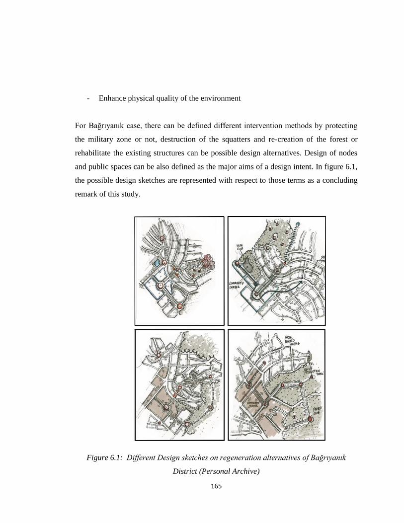
165
- Enhance physical quality of the environment
For Bağrıyanık case, there can be defined different intervention methods by protecting
the military zone or not, destruction of the squatters and re-creation of the forest or
rehabilitate the existing structures can be possible design alternatives. Design of nodes
and public spaces can be also defined as the major aims of a design intent. In figure 6.1,
the possible design sketches are represented with respect to those terms as a concluding
remark of this study.
Figure 6.1: Different Design sketches on regeneration alternatives of Bağrıyanık
District (Personal Archive)

166
7. REFERENCES
Akkerman, A., 2010. Harmonies of Urban Design and Discords of City-form: Urban
Aesthetics in the Rise of Western Civilization
Ataman,D., 1996. Through the Age of Antakya
Ayataç, H., 2003. Urban Design: A Key to Urban Regeneration, ITU Faculty of
Architecture, Urban and Regional Planning Deprtament, Taşkışla
Baldwin, J.M., 1905. Dictionary of Philosophy and Psychology. Retrieved from;
https://archive.org/details/dictionaryphilo00baldgoog. Last access: 03.03.2011.
Ball, M., Hanloe, M., Mantons, M., (n.d.) Housing and Social Change in Europe and
USA, Journal of Social Policy.
Baş, Y., 2003. Designing Urban Space with the Tools of the Development Legislation,
METU Thesis
Bianchini,F., Parkinson, M., 1993. Cultural Policy and Urban Regeneration, thev West
European Experience, Manchester University
Boratav, K., 2003. Türkiye İktisat Tarihi (1908-2009), İmge Kitapevi.
Chapman, D., 2005. Applying macro urban morphology to urban design and
development planning: Valletta and Floriana, Birmingham City University.
Collins, G., Collins, C., 1965. Camillo Sitte The Birth of City Planning, Dover
Crawford, J.H., 2005. A Brief History of Urban Form Street Layout Through the Ages.
Retrieved in http://www.carfree.com/papers/huf.html. Last access: 01.06.2014.
Dündar, Ö., 2001. Models of Urban Transformation: Informal Housing in Ankara, Gazi
University, Ankara.
Erol, D., n.d.. Ankara‟da Gecekondulaşma Süreci: Barakadan Mega Projelere, Dosya
Kent ve Gecekondu (p. 28), İlbank Yayınları Retrieved from;
http://www.ilbank.gov.tr/dosyalar/dergi/ilbank9/html/files/assets/downloads/page0030.p
df. Last access: 10.06.2012
Fainstein, S., 1994. The City Builders, University Press of Kansas.

167
Gauthier, P. and Gilliland, J., 2005. Mapping urban morphology: a classification scheme
for interpreting contributions to the study of urban form. Retrieved from;
http://www.researchgate.net/publication/42242470_Mapping_Urban_Morphology_A_C
lassification_Scheme_for_Interpreting_Contributions_to_the_Study_of_Urban_Form.
Last access: 04.04.2012.
Grebler, L., 1964. Urban Renewal in European Countries: Its Emergence and Potentials,
University of Pennsylvania
Gottdiener, M., 1985. Social Production of Urban Space, University of Texas
Gunay, B., 2009, Conservation of Urban Space as an Ontological Problem, METU
Harvey, J., 1981. The Economics of Real Property, Thirsk, United Kingdom.
ICOMOS, 2010, Disappearing Agrarian Culture and Its Architectural Heritage in
Antakya, ICOMOS Thailand International Conference 2013 ‖ Asian Forgotten Heritage
‖ Chiang Mai
İveynat, N. 2008, Urban Transformation Project in Squatter Settlements: The Case of
Ankara, Şentepe Urban Transformation Project, M.S. Thesis, METU, Ankara
Jansen, H., 1937. Ankara Development Plan Report
Kaba, B., 1995. Yeni Mahalle, Yenir Mahalle, Yenik Mahalle, Mimarlık 54 95/261
Li,Z., Yani, H., Aii, T., Chen, J.,2004. Automated building generalization based on
urban morphology and Gestalt theory. Retrieved from;
http://www.tandfonline.com/doi/abs/10.1080/13658810410001702021#.U5B8l_l_uYI.
Last access: 15.12.2013.
Lichfield, D., 1984. Alternative Strategies for Redistribution in Urban Renewal, SAGE
Publications, London.
Lozano, E., 1990. Community Design and Cultures of Cities, Cambridge University
Press; First edition
Lynch, K., 1984. Good City Form, MIT Press
Madinapour, A., 2003. Public and Private Spaces of the City, Routlefge, New York.

168
MIGM, Mahalli İdareler Genel Müdürlüğü, 2013. Mevzuat, Retrieved from;
http://migm.gov.tr/MevzuatKanunlar.aspx?KanunId=. Last access: 18.04.2012.
Özdemirli, Y., 2012. An Institutional Analysis of the Transformation of Informal
Housing Settlements in Turkey: A Case Study in the Sentepe Neighbourhood of Ankara,
METU PhD Thesis
Panerai, P., Castex, J., Depaule J. C., 2004. Urban Form: the Death and Life of the
Urban Block, British Library Catalogue.
Park, R., Burgess E., R.D. McKenzie, 1967. The City, The University of Chicago Press,
London.
Pizarro, R.E., Wie, L., Banerjee, T.,2003. Agencies of Globalization and Third World
Urban Form: A Review. Journal of Planning Literature.
Rifaioğlu, M.; Şahin, G., Neriman; L. Peter J., 2010. The influence of Land Ownership
and Control on Urban Form in the Historic Urban Core of Antakya, METU
Robinson, R., n.d. Rent Control
Sat, N., 2007. A critique on Improvement Plans: A Tool for Transformation of Squatter
Housing Areas in Ankara
Scott, A. & Soja, E., 1997. The City. Berkeley: University of California Press
Short, Y., 1996. The Urban order, Housing Market. Oxford: Blackwell.
Şenyapılı, T., 2004. Charting the Voyage of the Squatter Housing in Turkey
Şengül, T., 2009. Kentsel Çelişki ve Siyaset, İmge Kitapevi.
Türel, A., 1979. A Study of Squatter Housing
Tellis, W., 1997. Introduction to Case Study; he Qualitative Report, Volume 3, Number
2, July, 1997. Retrieved from: http://www.nova.edu/ssss/QR/QR3-2/tellis1.html. Last
access: 15.05.2014
Trancik, R., 1986. Finding the Lost Space: Theories of Urban Design, John Wiley &
Sons
Tankut, G., 1991. Bir Başkentin İmarı: Ankara (1929-1939)
Türksoy, H.C., 1996. İmar Affı mı?

169
TUIK, 2011. Adrese Dayali Nüfus Kayit Sistemi (ADNKS) Veri Tabani. Retrieved
from;http://rapor.tuik.gov.tr/reports/rwservlet?adnksdb2&ENVID=adnksdb2Env&repor
t=wa_turkiye_ilce_koy_sehir.RDF&p_il1=31&p_kod=1&p_yil=2011&p_dil=1&desfor
mat=html. Last access: 05.05.2014
U.S. Department of Housing and Urban Development Office of Policy Development and
Research ,n.d. Creating Defensible Space
Ward, P., Macoloo, C., 1992. Articulation Theory and Self-Help Housing Practice in
1990s
Ward,S., 1994. Planning and Urban Change, SAGE Publications, London.
Vaughan, L., Clark, D., Sahbaz, O., Haklay.M., n.d. Space and Exclusion: Does Urban
Morphology Play a Part in Social Depreviation?. Retrieved from;
http://onlinelibrary.wiley.com/doi/10.1111/j.1475-4762.2005.00651.x/abstract. Last
access: 26. 02. 2014.