Embed Size (px)
Citation preview
11.5A ANALYSIS OF THE USE OF AEROSPACE METEOROLOGY IN THE BRAZILIAN SPACE PROGRAM
Amaury Caruzzo1*; Mischel Carmen Neyra Belderrain1; Gilberto Fisch2
1Instituto Tecnológico de Aeronáutica (ITA), São José dos Campos, São Paulo – Brasil 2Instituto de Aeronáutica e Espaço (IAE), São José dos Campos, São Paulo – Brasil
1. INTRODUCTION*
In launching aerospace vehicles (rockets and space vehicles), the weather and environmental conditions are crucial. The process of "GO" or "NO GO" decision making can be extremely complex, depending on environmental conditions and the uncertainty of information. For a correct decision to be made, all the operational procedures have to be mapped, limiting weather factors have to be identified, and the infrastructure at the launch centers has to be analyzed, among many other aspects. That is, weather risk and decision analysis with a systemic view has to be carried out. Although these procedures are widespread at other space programs in the world, with many papers in the scientific literature (Case et al., 2005; Merceret et al., 2006; Kuk et al., 2011; Devyatkin et al., 2012), in Brazil specific studies in space activities are still at a preliminary stage. Therefore, this paper is intended as the first to use mapping and application of Aerospace Meteorology – AM (definition from Vaughan and Johnson, 2011) in the Brazilian Space Program, considering the different actors and operational aspects of vehicles launched from Brazil. 2. THE BRAZILIAN SPACE PROGRAM
The Brazilian Space Program (PEB) began operating in 1965 with the launch of the first sounding rocket from Brazil (Brasil, 2005; Prado, 2011). In the late 1970s the Brazilian government established the Brazilian Complete Space Mission, which defined three main goals for the PEB: to launch a satellite with a rocket, both made in Brazil, from a Brazilian launch center (Brasil, 2005; 2008; Prado, 2011). Since then, two institutions have been central to Research and Development (R&D) at the PEB: Institute of Aeronautics and Space (IAE), and the National Institute for Space Research (INPE).
Brazil currently has two centers to launch aerospace vehicles: Barreira do Inferno Launch Center (CLBI), at geographical coordinates lat 5º 55’ 30’’S; long 35º 10’ 00’’W and Alcantara Launch
* Corresponding author address: Amaury Caruzzo – Instituto Tecnológico de Aeronáutica (ITA), Grupo de Estudos de Análise de Decisão (GEAD), Praça Mal. Eduardo Gomes, 50, São José dos Campos/SP, 12228-900 – Brasil E-mail: [email protected]
Center (CLA), lat 2º 19’ 05’’S; long 44º 22’ 04’’W. Important to mention that the IAE, CLBI and CLA are organizations of Department of Aerospace Science and Technology (DCTA).
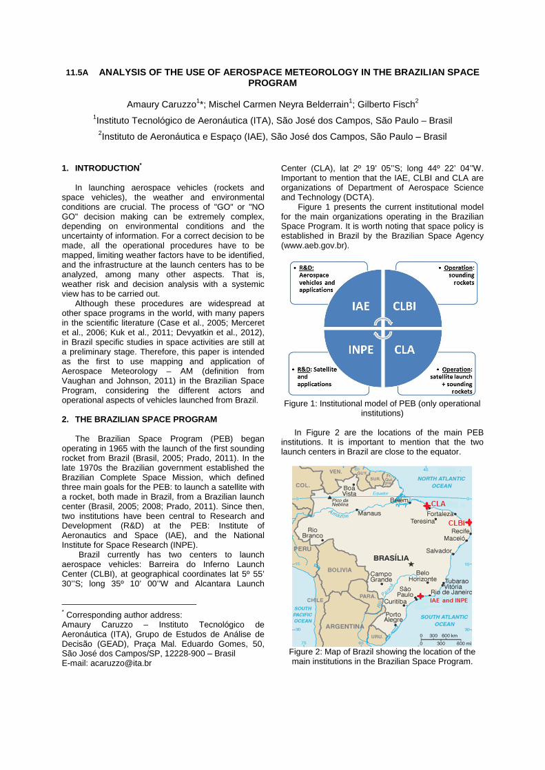
Figure 1 presents the current institutional model for the main organizations operating in the Brazilian Space Program. It is worth noting that space policy is established in Brazil by the Brazilian Space Agency (www.aeb.gov.br).
Figure 1: Institutional model of PEB (only operational
institutions)
In Figure 2 are the locations of the main PEB institutions. It is important to mention that the two launch centers in Brazil are close to the equator.
Figure 2: Map of Brazil showing the location of the main institutions in the Brazilian Space Program.
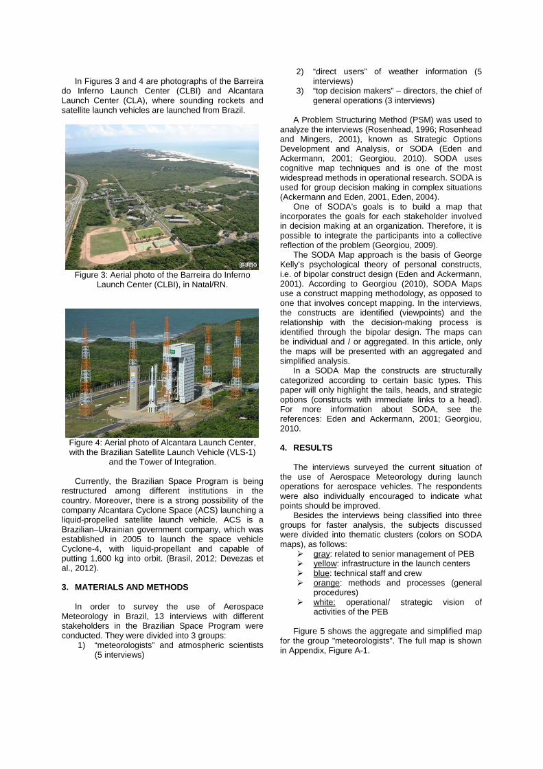
In Figures 3 and 4 are photographs of the Barreira do Inferno Launch Center (CLBI) and Alcantara Launch Center (CLA), where sounding rockets and satellite launch vehicles are launched from Brazil.
Figure 3: Aerial photo of the Barreira do Inferno
Launch Center (CLBI), in Natal/RN.
Figure 4: Aerial photo of Alcantara Launch Center, with the Brazilian Satellite Launch Vehicle (VLS-1)
and the Tower of Integration. Currently, the Brazilian Space Program is being restructured among different institutions in the country. Moreover, there is a strong possibility of the company Alcantara Cyclone Space (ACS) launching a liquid-propelled satellite launch vehicle. ACS is a Brazilian–Ukrainian government company, which was established in 2005 to launch the space vehicle Cyclone-4, with liquid-propellant and capable of putting 1,600 kg into orbit. (Brasil, 2012; Devezas et al., 2012). 3. MATERIALS AND METHODS
In order to survey the use of Aerospace Meteorology in Brazil, 13 interviews with different stakeholders in the Brazilian Space Program were conducted. They were divided into 3 groups:
1) “meteorologists” and atmospheric scientists (5 interviews)
2) “direct users” of weather information (5 interviews)
3) “top decision makers” – directors, the chief of general operations (3 interviews)
A Problem Structuring Method (PSM) was used to
analyze the interviews (Rosenhead, 1996; Rosenhead and Mingers, 2001), known as Strategic Options Development and Analysis, or SODA (Eden and Ackermann, 2001; Georgiou, 2010). SODA uses cognitive map techniques and is one of the most widespread methods in operational research. SODA is used for group decision making in complex situations (Ackermann and Eden, 2001, Eden, 2004).
One of SODA’s goals is to build a map that incorporates the goals for each stakeholder involved in decision making at an organization. Therefore, it is possible to integrate the participants into a collective reflection of the problem (Georgiou, 2009). The SODA Map approach is the basis of George Kelly’s psychological theory of personal constructs, i.e. of bipolar construct design (Eden and Ackermann, 2001). According to Georgiou (2010), SODA Maps use a construct mapping methodology, as opposed to one that involves concept mapping. In the interviews, the constructs are identified (viewpoints) and the relationship with the decision-making process is identified through the bipolar design. The maps can be individual and / or aggregated. In this article, only the maps will be presented with an aggregated and simplified analysis. In a SODA Map the constructs are structurally categorized according to certain basic types. This paper will only highlight the tails, heads, and strategic options (constructs with immediate links to a head). For more information about SODA, see the references: Eden and Ackermann, 2001; Georgiou, 2010. 4. RESULTS
The interviews surveyed the current situation of the use of Aerospace Meteorology during launch operations for aerospace vehicles. The respondents were also individually encouraged to indicate what points should be improved. Besides the interviews being classified into three groups for faster analysis, the subjects discussed were divided into thematic clusters (colors on SODA maps), as follows:
� gray: related to senior management of PEB � yellow: infrastructure in the launch centers � blue: technical staff and crew � orange: methods and processes (general
procedures) � white: operational/ strategic vision of
activities of the PEB Figure 5 shows the aggregate and simplified map for the group "meteorologists". The full map is shown in Appendix, Figure A-1.
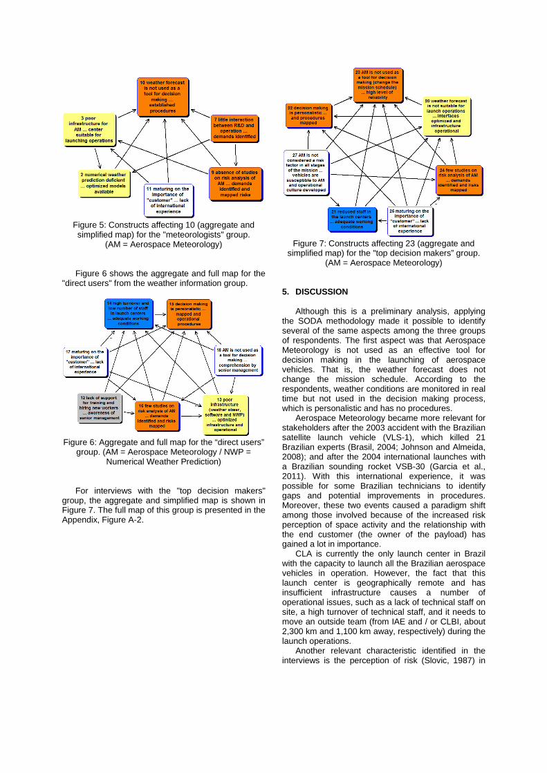
Figure 5: Constructs affecting 10 (aggregate and simplified map) for the "meteorologists" group.
(AM = Aerospace Meteorology) Figure 6 shows the aggregate and full map for the "direct users" from the weather information group.
Figure 6: Aggregate and full map for the “direct users”
group. (AM = Aerospace Meteorology / NWP = Numerical Weather Prediction)
For interviews with the "top decision makers" group, the aggregate and simplified map is shown in Figure 7. The full map of this group is presented in the Appendix, Figure A-2.
Figure 7: Constructs affecting 23 (aggregate and
simplified map) for the "top decision makers” group. (AM = Aerospace Meteorology)
5. DISCUSSION
Although this is a preliminary analysis, applying the SODA methodology made it possible to identify several of the same aspects among the three groups of respondents. The first aspect was that Aerospace Meteorology is not used as an effective tool for decision making in the launching of aerospace vehicles. That is, the weather forecast does not change the mission schedule. According to the respondents, weather conditions are monitored in real time but not used in the decision making process, which is personalistic and has no procedures.
Aerospace Meteorology became more relevant for stakeholders after the 2003 accident with the Brazilian satellite launch vehicle (VLS-1), which killed 21 Brazilian experts (Brasil, 2004; Johnson and Almeida, 2008); and after the 2004 international launches with a Brazilian sounding rocket VSB-30 (Garcia et al., 2011). With this international experience, it was possible for some Brazilian technicians to identify gaps and potential improvements in procedures. Moreover, these two events caused a paradigm shift among those involved because of the increased risk perception of space activity and the relationship with the end customer (the owner of the payload) has gained a lot in importance. CLA is currently the only launch center in Brazil with the capacity to launch all the Brazilian aerospace vehicles in operation. However, the fact that this launch center is geographically remote and has insufficient infrastructure causes a number of operational issues, such as a lack of technical staff on site, a high turnover of technical staff, and it needs to move an outside team (from IAE and / or CLBI, about 2,300 km and 1,100 km away, respectively) during the launch operations. Another relevant characteristic identified in the interviews is the perception of risk (Slovic, 1987) in
the "top decision makers" group. For this group, the weather is important, but is not considered a high risk factor. One example is that during launch operations, the meteorology team is under the flight safety group. This indicates that weather information is relevant only at the time of the launch of the aerospace vehicle without considering preceding (integration) and following (e.g. recovery of the payload) steps. A common thread to all groups of respondents is low interaction of Research and Development with operating Brazilian launching centers. The results of this low interaction are little theoretical risk analysis using Aerospace Meteorology (e.g. gas dispersion from rockets or accident scenarios in launch operations). A good example of this interaction is the Applied Meteorology Units at the Kennedy Space Center, which use the method: “bridge the gap between research and operations” (Madura et al., 2011). 6. CONCLUSION
Although the Brazilian Space Program is approximately 50 years old, three recent events have brought about a change of view among Brazilian stakeholders: a) the accident involving the VLS-1 in 2003, b) the recent international launch operations of sounding rockets with payloads since 2004 and c) the possibility of launching commercial satellites by Alcantara Cyclone Space (from 2005). It is precisely this shift in perspective (a new paradigm), which has made different stakeholders begin to think about problems not considered before. For example, only after 2007 (over 25 years after its creation) were a Weather Radar (X-band) and a Wind Profiler Radar purchased for the Alcantara Launch Center. This was difficult situation, since both meteorological instruments are essential to a good short-term weather forecast. In the case of low risk perception among the Top Decision Makers regarding meteorology in aerospace launch operations, it may be more closely associated with two particular situations in Brazil: a) the low number of aerospace vehicle launch operations (less than 1 per year); b) some Brazilian stakeholders do not consider meteorology activities important despite its tropical extreme weather events, since it does not have a hurricane season or harsh winters.
A series of strategic options (constructs with immediate links to the head) to develop Aerospace Meteorology activities in Brazil were identified in every group. Although the findings are preliminary, the common options among all the groups can be highlighted:
� Improve infrastructure to support meteorology and keep equipment operating
� Make a specific weather forecast for each type of mission and aerospace vehicle, with the development of numerical weather prediction and optimized procedures
� Conduct research in risk and decision analysis in Aerospace Meteorology in Brazilian parameters
7. DIRECTIONS FOR FUTURE RESEARCH
The following are suggested for future work: � Increase the number of respondents � Review SODA maps among all respondents � Identify best practices and potential
improvements for the development of Aerospace Meteorology in Brazil
� Implement a Multi-Criteria Decision Making (MCDM) method to implement the improvements identified
� Draw up risk analysis and evaluate environmental factors limiting the launch of Brazilian aerospace vehicles
� Parameterize a Decision Support System (DSS) using Aerospace Meteorology
8. ACKNOWLEDGMENT
This study has been supported by CNPq –
Brazilian National Council for Scientific and Technological Development, under grant number 142212/2011-3 (PhD scholarship). The authors also thank all the respondents for their contributions. However, any opinions, conclusions or suggestions in this paper are those of the authors and do not necessarily reflect the views of Brazilian Space Program institutions. 9. REFERENCES Ackermann, F., and C. Eden, 2001: SODA - Journey Making and Mapping in Practice. Rational Analysis for a Problematic World Revisited: Problem Structuring Methods for Complexity, J. Rosenhead and J. Mingers, Eds., John Wiley & Sons, West Sussex, 43–60. BRASIL, Ministry of Defense., 2004: Report of the accident investigation VLS-1 V03 (in Portuguese). 1 ed. COMAER. São José dos Campos, http://www.defesanet.com.br/docs/VLS-1_V03_RelatorioFinal.pdf (Accessed April 20, 2012). BRASIL, Brazilian Space Agency., 2005: National Program of Space Activities 2005 - 2014 (PNAE). 1st ed. AEB, Brasília, http://www.aeb.gov.br/download/PDF/pnae_web.pdf (Accessed December 16, 2012). BRASIL, Ministry of Defense., 2008: National Strategy of Defense. 1st ed. Brasília, http://www.defesa.gov.br/projetosweb/estrategia/arquivos/estrategia_defesa_nacional_ingles.pdf (Accessed December 16, 2012).
BRASIL, Ministry of Science and Technology., 2012: National Strategy for Science, Technology and Innovation 2012 – 2015 (in Portuguese). 1 ed. MCTI, Brasília, http://www.fortec-br.org/EstrategiaNacionaldeCTIdoMCTI.pdf (Accessed April 20, 2012). Case, J. L., M. M. Wheeler, J. Manobianco, J. W. Weems, and W. P. Roeder, 2005: A 7-Yr Climatological Study of Land Breezes over the Florida Spaceport. J Appl Meteorol, 44, 340–356, doi:10.1175/JAM-2202.1. Devezas, T., F. C. L. de Melo, M. L. Gregori, M. C. V. Salgado, J. R. Ribeiro, and C. B. C. Devezas, 2012: The struggle for space: Past and future of the space race. Technol Forecast Soc, 79, 963–985, doi:10.1016/j.techfore.2011.12.006. Devyatkin, A. M., V. M. Krasnov, Y. V. Kuleshov, A. B. Makov, and S. S. Suvorov, 2012: The use of information on atmospheric conditions for determining the impact areas of space rocket modules. Russ Meteorol Hydrol, 37, 98–105, doi:10.3103/S1068373912020045. Eden, C., 2004: Analyzing cognitive maps to help structure issues or problems. Eur J Oper Res, 159, 673–686, doi:10.1016/S0377-2217(03)00431-4. Eden, C., and F. Ackermann, 2001: SODA - The Principles. Rational Analysis for a Problematic World Revisited: Problem Structuring Methods for Complexity, J. Rosenhead and J. Mingers, Eds., John Wiley & Sons, West Sussex, 21–41. Garcia, A., S. S. C. Yamanaka, A. N. Barbosa, F. C. P. Bizarria, W. Jung, and F. Scheuerpflug, 2011: VSB-30 sounding rocket: history of flight performance. J. Aerosp. Technol. Manag., 3, 325–330, doi:10.5028/jatm.2011.03032211. Georgiou, I., 2009: Mapping Railway Development Prospects in Brazil. Transport Rev, 29, 685–714, doi:10.1080/01441640902752813. Georgiou, I., 2010: Cognitive Mapping and Strategic Options Development and Analysis (SODA). Wiley Encyclopedia of Operations Research and Management Science, J.J. Cochran, Ed., John Wiley & Sons, 1–10. doi:10.1002/9780470400531.eorms0974 Johnson, C. W., and I. M. de Almeida, 2008: An investigation into the loss of the Brazilian space programme’s launch vehicle VLS-1 V03. Safety Sci, 46, 38–53, doi:10.1016/j.ssci.2006.05.007.
Kuk, B.-J., H.-I. Kim, J.-S. Ha, and H.-K. Lee, 2011: Intercomparison Study of Cloud-to-Ground Lightning Flashes Observed by KARITLDS and KLDN at South Korea. J Appl Meteorol Clim, 50, 224–232, doi:10.1175/2010JAMC2493.1. Madura, J. T., W. H. Bauman-III, F. J. Merceret, W. P. Roeder, F. C. Brody, and B. C. Hagemeyer, 2011: The Applied Meteorology Unit: Nineteen years successfully transitioning research into operations for America’s Space Program. 27th Conference on Interactive Information Processing Systems, American Meteorological Society, 1–9 https://ams.confex.com/ams/91Annual/webprogram/Manuscript/Paper179272/J10dot2_final_Submitted.pdf (Accessed October 27, 2012). Merceret, F. J., D. A. Short, and J. G. Ward, 2006: Radar Evaluation of Optical Cloud Constraints to Space Launch Operations. J Spacecraft Rockets, 43, 248–251, doi:10.2514/1.17519. Prado, A. F. B. de A., 2011: Editorial - A short history of the academic activities at the Brazilian National Institute for Space Research. J. Aerosp. Technol. Manag., 3, 5–12. http://www.jatm.com.br/papers/vol3_n1/JATMv3n1_p5-12_editorial_a_short_history_of_the_academic_activities_at_the_Brazilian_National_Institute_for_Space_Research.pdf. Rosenhead, J., 1996: What’s the problem? An introduction to Problem Struturing Methods. Interfaces, 26, 117–131, doi:10.1287/inte.26.6.117. Rosenhead, J., and J. Mingers, 2001: Rational Analysis for a Problematic World Revisited: Problem Structuring Methods for Complexity. 2nd ed. John Wiley & Sons, West Sussex,. Slovic, P., 1987: Perception of Risk. Science, 236, 280–285, doi:10.1126/science.3563507. Vaughan;, W. W., and D. L. Johnson, 2011: Aerospace Meteorology: Some lessons learned from the development and application of NASA terrestrial environment design criteria. B Am Meteorol Soc, 92, 1149–1157, doi:10.1175/2011BAMS3133.1.
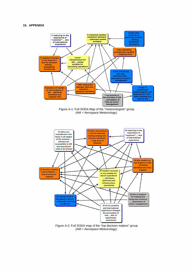
10. APPENDIX
Figure A-1: Full SODA Map of the "meteorologists" group
(AM = Aerospace Meteorology).
Figure A-2: Full SODA map of the "top decision makers” group
(AM = Aerospace Meteorology).