Embed Size (px)
Citation preview

ANALYSIS OF SPRING BREAK-UP DATA
IN VIRGINIA T. E. SHELBURNE and A. W. MANER V i r g i n i a Department of Highways
SYNOPSIS
The paper p r e s e n t s an a n a l y s i s o f road performance data c o l l e c t e d a t the time o f the s p r i n g break-up on more than 1000 m i l e s o f p r i m a r y and n e a r l y 5000 m i l e s o f s e c o n d a r y roads i n t h e Culpeper D i s t r i c t . The p u rpose o f t h e s u r v e y was t o secure d e t a i l e d i n f o r m a t i o n on road performance and t o d e t e r m i n e t h e e x t e n t and, i n s o f a r as p o s s i b l e , t h e causes o f t h e major break-up. R e s u l t s o f such a s u r v e y a r e u s e f u l i n c o n j u n c t i o n w i t h t h e p l a n n i n g o f maintenance and cons t r u c t i o n programs
A u n i f o r m system o f r a t i n g the numerous road s e c t i o n s was devised. Five r a t i n g s , d e p e n d i n g upon t h e degree o f d i s t r e s s , were employed. The s u r v e y was s t a r t e d about the middle o f February, 1948 and a l l f i e l d work was completed near t h e f i r s t o f A p r i l . Thus, a l l r a t i n g s were o b t a i n e d a t a t i m e when subgrade s u p p o r t was a t a minimum.
The p e r f o r m a n c e r a t i n g s b o t h f o r t h e p r i m a r y and f o r t h e s e c o n d a r y r o a d s were summarized by c o u n t i e s . The secondary roads were f u r t h e r d i v i d e d i n t o hard and non-hard s u r f a c e t y p e s . A map o f eacS county was prepared showing the r a t i n g s f o r each road s e c t i o n .
D e s p i t e the f a c t t h a t p r i m a r y highways c a r r y a p p r o x i m a t e l y 80 p e r c e n t o f the t r a f f i c , t h e i r performance was c o n s i d e r a b l y b e t t e r than t h a t o f secondar/ roads. For example, about 43 p e r c e n t o f the p r i m a r y roads were g i v i n g good performance ( r a t i n g s 1 and 2) as compared t o o n l y 20 p e r c e n t o f the secondary roads. Likew i s e , o n l y 29 p e r c e n t o f the p r i m a r y highways were r a t e d as poor ( r a t i n g s 4 and 5 ) . w h i l e 47 p e r c e n t o f the secondary roads were i n t h i s c a t e g o r y .
For the p u rpose o f a n a l y s i s t h e Culpeper D i s t r i c t was d i v i d e d i n t o f i v e g e n e r a l s o i l areas a c c o r d i n g t o p a r e n t m a t e r i a l s . I t was found t h a t the roads i n the Coastal P l a i n Sediments s o i l area were g i v i n g the best performance, w h i l e those i n the T r i a s s i c "Red Beds" s o i l area were r a t e d the p o o r e s t i n the D i s t r i c t .
The s t u d i e s r e v e a l e d t h a t i n a l l f i v e s o i l a r e as macadam bases p e r f o r m e d much b e t t e r than s e l e c t e d s o i l , g r a v e l , stone or s t a b i l i z e d bases. The order o f r a t i n g s f o r b i t u m i n o u s s u r f a c e s f r o m t h e b e s t t o p o o r e s t p e r f o r m a n c e was as f o l l o w s - p l a n t mix, heavy bituminous mixes and l i g h t b i tuminous mixes.
An a n a l y s i s o f the 30-year weather r e c o r d s (1917-1947) br o u g h t t o l i g h t cert a i n p e r t i n e n t f a c t s . I t was found t h a t pavement break-ups are most severe f o r t h o s e y e a r s w i t h low t e m p e r a t u r e s p r e c e d e d by subgrade and base s a t u r a t i o n ( h i g h p r e c i p i t a t i o n ) . The p a s t w i n t e r was second o n l y t o t h e 1935-36 one as r e g a r d s t o c l i m a t i c c o n d i t i o n s f a v o r a b l e t o a severe break-up.
I n order to design, construct and main- i o r of pavements. Road condition surveys, t a i n b e t t e r roads, highway engineers are i f made at a time when differences i n per-making use of research t o evaluate the formance are most apparent, can be useful various factors responsible for the behav- f o r t h i s purpose. A comprehensive and

DESIGN AND SOILS
thorough study at the time of the spring break-up w i l l not only serve the purpose of l o c a t i n g the areas where d i s t r e s s i s most prevalent, but also may serve to i n d i c a t e the best s o l u t i o n t o some of the problems.
Good pavement performance i s dependent upon a number o f f a c t o r s . Often these f a c t o r s are so i n t e r r e l a t e d t h a t i t becomes alnost a hopeless task to i s o l a t e and evaluate each factor i n d i v i d u a l l y for some p a r t i c u l a r section of road. A study of a large number of pavements may b r i n g t o l i g h t c e r t a i n f a c t s not o t h e r w i s e obtainable. Among the important variables are climate, t r a f f i c , design and the s o i l area i n which the pavement i s lo c a t e d . A l l highway engineers have observed that the s p r i n g break-up i s much more severe some years than o t h e r s . What are the c l i m a t i c f a c t o r s which c o n t r i b u t e t o a major spring break-up' What pavement designs are g i v i n g " year-around" good performance f o r the t r a f f i c c o n d i t i o n s to which they are subjected' In what areas are the roads distressed the most at the time of the "break-up"'
To answer these questions the Department c o l l e c t e d d e t a i l e d i n f o r m a t i o n on weather data, and road performance t h i s past spring to determine insofar as poss i b l e the extent and causes of the major break-ups. Tbe survey was extensive since I t included the 38,000 mi. i n the secondary system and the 9,000 mi. of primary highways. I t was started about the middle o f February and a l l f i e l d work was completed near the f i r s t of A p r i l . The survey consisted o f an inspection, logging and desc r i p t i o n of f a i l u r e types (surface and base) and a performance r a t i n g o f each i n d i v i d u a l road section. Pictures were taken to i l l u s t r a t e both poor and good performance and to record actual conditio n s .
I n a d d i t i o n to the f i e l d survey, an analysis was made of the 30 yr. weather data throughout the S t a t e . For t h i s analysis the rep o r t s from 1-6 US Weather Bureau s t a t i o n s (two per d i s t r i c t ) were used.
I t may be p e r t i n e n t at t h i s time t o note that the f i e l d p a r t i e s were a l e r t e d to pay p a r t i c u l a r a t t e n t i o n t o road damage
being caused by excessive loads. During the time o f the break-up load l i m i t r e s t r i c t i o n s were placed on many highways. Most i n t e r s t a t e r o u t e s r e t a i n e d t h e i r designated 40,000-lb. gross load l i m i t ; however, many other primary roads were r e s t r i c t e d t o 24,000-lb. gross load and p r a c t i c a l l y a l l secondary routes were posted for 16,000 l b .
Results of the state-wide road condit i o n survey have been summarized by count i e s and d i s t r i c t s ; however, because of t h e i r bulk they are not included i n t h i s r e p o r t . More d e t a i l e d a n a l y s i s o f the data was d e s i r e d t o study the factors a f f e c t i n g pavement performance. Tbus, the paper presents an analysis of the survey r e s u l t s f o r the Culpeper D i s t r i c t -one of the eight i n the State.
DESCBIPTION OF THE CULPEPER DISTRICT
The Culpeper D i s t r i c t w i t h an area of 5021 sq. mi. i s located i n the north cent r a l part o f the State. I t is bounded by Maryland on the north, by the crest of the Blue Ridge Mountains on the west, by the James River and Nelson County on the south, by the Potomac River and S t a f f o r d , Spotsylvania, Hanover and Goochland Counties on the east. I t includes the f o l l o w i n g 13 counties: Albemarle, A r l i n g t o n , Culpeper, Fairfax, Fauquier, Fluvanna, Greene, Loudoun, Louisa, Madison, Orange, Prince William and Rappahannock.
The p o p u l a t i o n i n 1930 was 243,000, had increased to 304,500 i n 1940 and i s now estimated at over 400,000. Two i n dependent c i t i e s , Alexandria and Charl o t t e s v i l l e , have an estimated population of 58,000 and 25,000 respect i v e l y . Seve r a l o f the r u r a l c o u n t i e s have had a tendency t o lose some of t h e i r i n h a b i tants while others have gained. Especi a l l y noticeable for gains are A r l i n g t o n -which jumped from 57,000 i n 1940 to an estimated present population of 120,000 -and F a i r f a x which increased from 41,000 i n 1940 to 80,000 (estimated) i n 1948.
The D i s t r i c t i s divided i n t o s i x r e s i dencies. The o f f i c e s o f the Resident Engineers are located as f o l l o w s : Fluvanna and Louisa Counties at Louisa Court House, Albemarle and Greene Counties at

SHELBURNE AND MANER - SPRING BREAK-UP IN VIRGINIA
C h a r l o t t e s v i l l e ; Culpeper, Orange, and Madison Counties a t Culpeper; Fauquier and Rappahannock Counties at Warrenton, F a i r f a x , A r l i n g t o n , and Prince W i l l i a m Counties at Fairfax; and Loudoun County at Leesburg. The D i s t r i c t o f f i c e i s located at Culpeper.
The primary highway system includes 1175 mi. and the secondary road network has a mileage of 4958. I n a d d i t i o n , the County o f A r l i n g t o n m a i n t a i n s i t s own highway system. Approximately 60 mi. o f primary roads have been b u i l t to four-lane width, some of them being divided. H i i s l a s t type o f mileage w i l l be increased upon completion of the Henry Shirley Memo r i a l Highway.
The p r i n c i p a l primary highways i n the d i s t r i c t are: US Routes 1, 15, 29, 33, 50, 211 and 250. A t r a f f i c flow map as prepared by the D i v i s i o n of T r a f f i c and Planning i s presented m 'Figure 1. I t w i l l be noted t h a t t r a f f i c volume i s greatest on the above l i s t e d routes and i s concentrated p a r t i c u l a r l y i n the Washin g t o n area. A d d i t i o n a l data from the T r a f f i c and Planning D i v i s i o n reveal that while only 13 percent o f a l l roads i n the state system are i n the Culpeper D i s t r i c t , about 17 percent o f a l l t r a f f i c on the system i s found i n t h i s area.
The d i s t r i c t can be d i v i d e d i n t o two major physiographic provinces: the Piedmont Plateau and the Coastal Plain. The l a t t e r I S extremely l i m i t e d i n extent and stretches along a narrow north-south band of land i n A r l i n g t o n , Fairfax and Prince W i l l i a m Counties bordering the Potomac R i v e r . A l a r g e p a r t o f the Piedmont Plateau i n the Culpeper D i s t r i c t i s occupied by a series of Triassic Basins.
From a g e o l o g i c a l p o i n t o f view the formations encountered vary widely. Tlie o l d e s t one i s a p p a r e n t l y the C a t o c t i n greenstone, an extrusive rock of pre-Cam-b r i a n age (most l i k e l y A lgonkian). I t i s a basic lava which l i e s p a r a l l e l t o the eastern f l a n k of the Blue Ridge. Of s i m i l a r age are the widespread Wissahickon s c h i s t (a chlorite-muscovite s c h i s t ) and several g r a n i t i c formations such as: the M a r s h a l l , Hypersthene, Lovingston and Columbia granites; hornblende gabbro and
quartz monzonite are two other igneous pre-Cambrian formations.
In the lower Cambrian are the Loudoun s l a t e and q u a r t z i t e . Sedimentary rocks are to be found i n the Culpeper D i s t r i c t . Of O r d i v i c i a n age are small out-crops of Arvonis and Quantico s l a t e , and Everona limestone. F i n a l l y i n the T r i a s s i c basin are three main groups of sedimentary rocks, namely, conglomerates, sandstones and shales. The conglomerates are u s u a l l y c l a s s i f i e d according to component pebbles (limestone, quartz, schi s t , trap, arkose). The basins as w e l l as the remaining o f t h e p l a t e a u are c u t by a number o f diabase dykes, s i l l s and stocks. I n the Coastal Plain are to be found sediments, mostly arkosic, ranging from Cretaceous t o Pleistocene i n age. At places, along the Potomac, they are wholly unconsolidated and the most recent sediments are sand or peat and muck.
In the northern pa r t o f the d i s t r i c t the drainage i s toward the Potomac River. The c e n t r a l part i s drained by the Rappahannock and Rapidan on the one hand and the Anna Rivers on the other. Runoff i n the southern p a r t i s toward the James River and i t s t r i b u t a r i e s . The drainage pattern i s obviously a r e f l e c t i o n o f the topography. I n the Culpeper D i s t r i c t the high land l i e s to the west w i t h a series o f f o o t h i l l s s t r e t c h i n g about as f a r as the T r i a s s i c basins. I n those basins the r e l i e f i s markedly f l a t t e r . The re-mainingof the d i s t r i c t i s gently r o l l i n g .
Weather c o n d i t i o n s i n the d i s t r i c t , p a r t i c u l a r l y those a f f e c t i n g the s p r i n g break-up, may best be i l l u s t r a t e d by Figure 2. Data secured from the US Weather Bureau Station at C h a r l o t t e s v i l l e for the months of November, December, and January are presented g r a p h i c a l l y f o r a l l years since 1917. Average mean temperature and t o t a l p r e c i p i t a t i o n are p l o t t e d and compared w i t h the 35-yr. normal. I t w i l l be observed f o r t h i s 30-yr. period that the winter o f 1917-1918 was the coldest w i t h an average mean temperature of 33 F. Next come the w i n t e r s o f 1935-36 and 1939-40 each with a mean temperature of 37 F. The past w i n t e r was f o u r t h w i t h a mean temperature of 37.2 F.

DESIGN AND SOILS
INSERT 2
(NSERT 4
INSERT 9
Figure 1. Culpeper D i s t r i c t - T r a f f i c Flow Map, 1947 T r a f f i c Scale: 1/4-in. width = 5000 Vehicles.

SHELBURNE AND MANER - SPRING BREAK-VP IN VIRGINIA
• 1920 L
I9*S
"igureZ ClimaticData C h a r l o t t e s v i l l e , Va. Data are for November and December of
given year plus f o l l o w i n g January.
I n t o t a l p r e c i p i t a t i o n the w i n t e r o f 1936-37 was the w e t t e s t w i t h 15.5 i n . , however, the preceding winter (1935-36) was next w i t h 15 i n . These may he compared w i t h a 35-yr. normal f o r the three months period of 9.3 i n . Last winter the p r e c i p i t a t i o n was above normal being 10.4 i n .
Tbe most severe spring break-up i n recent years occurred i n 1935-36. An exami n a t i o n o f the chart reveals that an unusually low temperature (second lowest i n 30 years) was combined with an abnormally high p r e c i p i t a t i o n (second wettest w i n t e r ) . I t maybe pointed out that the past winter had the combination of p r e c i p i t a t i o n and temperature most favorable t o a severe break-up since 1935-36. The two items appear t o go hand i n hand and merely a c o l d winter does not necessarily r e s u l t i n a severe break-up.
Materials for highway construction and maintenance are found i n various parts of the d i s t r i c t . Sand and gravel i n the Coastal P l a i n are c u r r e n t l y being produced at several locations. Natural r i v e r sand can also be obtained at several l o cations where i t occurs as an alluvium. Stone from several formations i s used as
road metal. Several of the granites have been q u a r r i e d s u c c e s s f u l l y . Q u a r r i e s opened i n the Wissahickon formation have furnished a v a r i e t y o f g r a n i t i c rocks. A v a r i e t y of aggregates has also been produced from the T r i a s s i c "Red Beds". Seve r a l q u a r r i e s have been o p e r a t i n g f o r a number of years i n the conglonerate ( t r a p phase) and i n b a s a l t i c dykes. Tlie l a t t e r are extremely tough w i t h r e s u l t i n g wear on crushers. The Manassas sandstone o f T r i assic Age also has been used as road metal. Also, greenstone has been a source f o r road aggregates.
As may be expected, the s o i l s o f the area are a r e f l e c t i o n o f the geology. On the basis o f parent materials the d i s t r i c t has been d i v i d e d i n t o f i v e general s o i l areas as shown i n Figure 3. The Coastal P l a i n s o i l s vary w i d e l y from sand and pebbles t o mterbedded sand and c l a y . Along the shore l i n e some unconsolidated peat may be found i n marshy land. On the Piedmont P l a t e a u the g r a n i t i c r o c k s (whether metamorphosed or not) weather i n t o clays t o sandy clays. The s o i l type i s a f u n c t i o n o f the amount o f q u a r t z present i n the parent material - the more quartz present, the Jess p l a s t i c the s o i l . As a r u l e , the amount of quartz i n the granitoids varies inversely as the amount of clay forming minerals such as the f e l d spars, micas and members of the hornblende f a m i l y . The weathering process which transforms them i s not a simple one but i t can be s t a t e d t h a t through physical and chemical actions they are changed i n t o e l a s t i c and ( o r ) p l a s t i c s o i l s . Wherever the quartz and other s i l i c e o u s elements are predominant, the r e s u l t i n g s o i l s are e s s e n t i a l l y g r a n u l a r and n o n - p l a s t i c (sandy to s i l t y ) .
The T r i a s s i c basin i s very p r o p e r l y described as the "Red Bed" area since the s o i l s weather i n t o deep red-brown clay. Though the top horizon i s rather shallow near the Potomac, i t becomes deeper f u r t h e r south. The s o i l i s one o f the most unfavorable f o r highway work and, as i s often the case, i t i s also among the most favorable i n the State from an a g r i c u l t u r a l p o i n t o f view. The diabase dykes o f t e n weather i n t o a sand before breaking down

DESIGN AND SOILS
L E G E N D
S C A L E
0 5 10
H A N O V E R
N E L S O N
/ e ' u c K i H O H A i i • > " " " M U L M o
Figure 3. Culpeper D i s t r i c t - General Soil Areas.
i n t o a very heavy clay ( a g r i c u l t u r a l l y known as the I r e d e l l ) , which has j u s t l y been nicknamed " b l a c k jack s o i l " . The Tnassic sand as well as the clay i s most unfavorable f o r highway work. The v o l canic rocks which are mostly greenstone also break down i n t o clay. As a whole, I t may be s t a t e d t h a t from a highway s t a n d p o i n t , s o i l s encountered i n the Culpeper D i s t r i c t present problems because of poor i n t e r n a l drainage and v a r i able bearing power.
SURVEY PROCEDURE
Immediately a f t e r the assignment of the state-wide road c o n d i t i o n survey to the Research Section, the f i r s t step was the preparation of a working plan. Meetings were held w i t h the f i e l d forces who were
to conduct the survey. Specific i n s t r u c tions were issued to the D i s t r i c t Materials Engineers, the D i s t r i c t S o i l Engineers, Testing D i v i s i o n s t a f f members and f i e l d men assigned to the survey. The D i s t r i c t M a t e r i a l s Engineer was placed i n charge of the f i e l d survey and held responsible f o r i t s conduct i n each d i s t r i c t . Four or five f i e l d p a r t i e s , c o n s i s t i n g o f a d r i v e r and a recorder, were organized i n each d i s t r i c t . Thus, for conducting such an extensive survey i n a r e l a t i v e l y short time the services o f about 100 men were required.
The f i e l d p a r t i e s worked i n close cooperation with the D i s t r i c t Engineers and Resident Engineers and checked w i t h the l a t t e r at least once a day to report extensive or severe f a i l u r e s so t h a t they could be corrected and thus expedite t r a f -

SHELBURNE AND MANER - SPRING BREAK-UP IN VIRGINIA
f i c . The d r i v e r o f the two-man p a r t y was usually a road patrolman who was i n t i m a t e l y f a m i l l a r w i t h l o c a l c o nditions. Tlie recorder prepared the l o ^ , rated the roads, took pictures to i l l u s t r a t e t y p i c a l conditions and kept a l l notes.
Prior to beginning the survey each party was supplied a l i s t of road sections by counties which had been prepared on the I.̂ B.M. machine by the Auditing D i v i s i o n . These tabulations contained the following information. (1) county code, (2) route number, (3) d e s c r i p t i o n ( f r o m , t o ) , (4) surface type (by code), (5) base type (by code), (6) road width and (7) length. In addition, each party was furnislied the f o l l o w i n g supplies and equipment- f i e l d note book (one per county), code o f count i e s , code f o r base and surface types, county maps, state maps, l i s t of Resident Engineers and counties i n each Residency, c o l o r e d p e n c i l s , p i c k , shovel, s c a le, camera, supply of f i l m , working plan and set o f i n s t r u c t i o n s .
The survey was made by d r i v i n g at slow speed over each section o f road, n o t i n g and recording conditions m a f i e l d note book. T^ie same general procedure was f o l lowed i n each of the eight d i s t r i c t s . For each road section the f o l l o w i n g information was recorded i n the county f i e l d book: (1) survey party, (2) date inspected, (3) weather c o n d i t i o n s , (4) l o g o f s e c t i o n l o c a t i n g type and extent of f a i l u r e s , and other information pertinent to performance such as: topography, predominating s o i l type, position of grade l i n e with respect to ground surface and water table, drainage c o n d i t i o n s , unusual t r a f f i c c o n d i t i o n s , etc.
Immediately a f t e r logging and inspecting a given section, an estimate was made of the degree of d i s t r e s s and a r a t i n g was given on the basis of the a r b i t r a r y evaluations l i s t e d i n Table 1.
As soon as the r a t i n g had been e s t i mated, the road was colored on the county map according t o the color code given i n the Table. I f only surface f a i l u r e s were encountered, short lines perpendicular to the road were colored on the map. When the f a i l u r e s were found i n both surface and base, a s o l i d color was used. Thus,
uniform r a t i n g and color schemes were used in a l l d i s t r i c t s . I t i s realized that i t i s not always easy to d i s t i n g u i s h between " w i n t e r damage" and t h a t r e s u l t i n g from delayed or d e f e r r e d maintenance. The ratings r e f l e c t conditions e x i s t i n g at the time of the spring break-up, regardless of t h e i r cause.
About 600 p i c t u r e s were taken to record t y p i c a l road conditions and to i l l u s t r a t e both good and poor performance. At the completion of the survey each Dist r i c t Materials Engineer prepared a report and submitted the data for each d i s t r i c t . Included i n the report was a colored map of each county showing the r a t i n g of each road section. The reports contained tabu l a t i o n s showing the number o f miles of primary and secondary roads i n each r a t i n g by counties. Secondary roads were further divided i n t o those w i t h hard surfaces and the ones without. Some of the reports supplied information concerning the d i f f e r e n t types o f co n s t r u c t i o n and some contained recommendations f o r improvements i n design, c o n s t r u c t i o n and maintenance procedures.
In order to secure further information concerning the e f f e c t o f such variables as s o i l area, base and surface types, an a n a l y s i s o f the survey results i n one typi c a l d i s t r i c t ((illpeper) was attempted.
CULPEPER DISTRICT SURVEY RESULTS
Primary Roads - Results of the condition survey o f primary roads have been summarized according'to r a t i n g s f o r each of the 13 counties m Table 2. The summary includes not only the t o t a l mileage but also the percentage i n each r a t i n g . These data are a l s o presented g r a p h i c a l l y i n Figure 4. I t w i l l be observed that about 505 mi. or 43 percent of the primary roads were g i v i n g good performance ( r a t i n g s 1 and 2). In contrast, only about 348 mi. or 29.5 percent were considered as g i v i n g poor performance ( r a t i n g 4 and 5). More than 50 percent of the primary roads i n two counties, Albemarle and Fairfax, were r a t e d good. I n c i d e n t a l l y , these two counties are two of the heaviest populated counties m the D i s t r i c t and the primary

DESIGN AND SOILS
Rating
1. Excel l a i t Perfonnance
2. Good perfonnance
3. S l i g h t Distress
4. Secondary Distress
5. Primary Failure
1. Excellent
2. Good
3. Fair
4. Poor
5. Very Poor
TABLE 1
Hard Surface Roads
Description Roads showing no break-up and i n perfect condition.
Roads shewing only a s l i g h t amount of distress such as an occassional a l l i g a t o r crack or some surface raveling.
Those roads with less than 5% of the t o t a l area showing base and surface movement.
Hiose roads showing 5 to 20 % of the t o t a l area with movement i n the base and surface.
Hiose roads with over 20% of the surface showing base and surface movement.
Color Code Blue
Green
Brown
Orange
Red
Non-Hard Surface Roads
Remained smooth w i t h no break-ups. Blue
No break-up. S l i c k i n places but no Green ru t s deeper than 1 i n . T r a f f i c moving in high gear on e n t i r e section.
Not over 5% badly r u t t e d so as t o Brown force t r a f f i c t o change gears.
From 5% to 20% badly r u t t e d . T r a f f i c Orange may get stuck i n places.
Over 20% of surface badly r u t t e d . Very Red d i f f i c u l t for t r a f f i c to pass without g e t t i n g stuck.
roads i n them carry more t r a f f i c than i n most of the other counties. On the other hand, more than 50 percent of the primary roads i n Fauquier, Fluvanna, Greene and Loudoun counties were rated as showing considerable d i s t r e s s ( r a t i n g s 4 and 5).
A map o f the primary highways was prepared t o show the c o n d i t i o n r a t i n g o f each road section (Figure 5). I t w i l l be noted t h a t considerable mileage of Rts. 7, 15, 17, 28 and 233 were rated as primary f a i l u r e ( r a t i n g 5). Typical performance p i c t u r e s are i l l u s t r a t e d i n Figures 6-9 inc l u s i v e .
Secondary Roads - Results o f the survey on secondary roads have been sumnarized i n a s i m i l a r manner f o r the twelve counties included i n t h i s system (Table 3 ) . The secondary roads have been further divided i n t o two groups: hard and non-hard surfaces. Of the 4958.47 mi. of secondary roads, only 857.48 mi. or 17.3 percent have a hard surface. While both classes of secondary roads were included i n the survey, only those secondary roads w i t h hard surfaces are included i n the analys i s . ODnditions of the unsurfaced secondary roads change so r a p i d l y t h a t t h e i r

SHELBURNE AND MANER - SPRING BREAK-VP IN VIRGINIA
10 4
I I I
e a t
14 ft
i
L E G E N 0
R A T I N G 1 - E X C E L L E N T P E R F O R M A N C E
R A T I N G 2 — G O O D PERFORMANCE
R A T I N G 3 — S L I G H T D I S T R E S S
R A T I N G 4 — SECONDARY D I S T R E S S
R A T I N G 5 — P R I M A R Y F A I L U R E
imnffi R A T I N G 6 — U N D E R C O N S T R U C T I O N
B 3 P R I M A R Y R O A D S N O T L O G G E D ( N O T S U R F A C E D )
10 T
I T !
JSL
H A R D S U R F A C E D S E C O N D A R Y R O A D S
i t
4 B J
40J
I I I
14 • • I S I I t
ALBCItAIILe ARURVTOM CULMHR fkinrki PAuouiCR rLuvAuA « n c a c ^
P R I M A R Y R O A D S
RAPR*. HAMHOCK
Figure 4. Road Mileage and Condition Ratings by Counties.
r a t i n g i s extremely d i f f i c u l t . Such a road may be impassible one day and rated as a primary f a i l u r e ; however, a f t e r blading and drying by sun and wind i t s condit i o n may have improved so much as to class I t as f a i r . F a i l u r e s o f hard surface roads are not so e a s i l y r e p a i r e d and t e l l - t a l e patches indicate past conditions.
Considering the hard surface secondary roads, 232.35 mi. (27 percent) were rated as g i v i n g good performance ( r a t i n g s 1 and 2) as compared to 399.23 mi. (47 percent) t h a t were showing considerable d i s t r e s s ( r a t i n g s 4 and 5 ) . I n only one county (Rappahannock) were more than 50 percent o f the hard surface secondary roads rated as showing good performance (r a t i n g s 1 and 2) . In contrast, more than 50 percent of the hard surface secondary roads were m poor condition ( r a t i n g s 4 and 5) i n f i v e c o u n t i e s - P r i n c e W i l l i a m , Fauquier, Loudoun, Madison and Culpeper. County maps were prepared showing the r a t i n g o f each secondary road, however, because of t h e i r bulk they are not included i n the r e p o r t . They are q u i t e u s e f u l t o the Resident and D i s t r i c t Engineers for planning maintenance and construction sched
u l e s . Conditions t y p i c a l on secondary roads at the time of the survey are i l l u strated by Figures 10, 11 and 12.
DISCUSSION OF RESULTS
In order t o s i m p l i f y the analysis o f the data, r a t i n g s 1 and 2 were combined and c l a s s i f i e d as good performance. Also, ratings 4 and 5 were combined and reclass i f i e d as poor performance. The data for the primary roads was then rearranged and summarized according t o s o i l area by base and s u r f a c e types (Table 4 ) . I t was thought that such a summary might be more r e v e a l i n g concerning the f a c t o r s upon which road performance i s dependent. I t I S recognized that there are many v a r i a tions o f s o i l due to topography and other f a c t o r s w i t h i n the f i v e general s o i l areas; however, the areas are based upon predominating parent materials. Informat i o n on base and surface types were secured from the road i n v e n t o r i e s as prepared by the Division of T r a f f i c and Plann i n g . Data on hard surface secondary roads was tabulated i n a s i m i l a r manner and I S summarized i n Table 5*

ALEXANDRIA ARLINGTON
AREA
F I G U R E 9 S P R I N G 1 9 4 8
CONDIT ION S U R V E Y R A T I N G S O F
PRIMARY ROADS L E S E N O
E X C E L L E N T PERFORMANCE
OOOO P E R F O R M A N C E
9 L I 0 N T D I S T R E S S
SECONDARY D ISTRESS
PRIMARY F A I L U R E
COMMONWEALTH OF VIRGINIA DEFWRTMENTOF HK3HWAYS
D M S O N O F T R A F F I C A N D P L A N N I N G
MAP OF CULPEPER DISTRICT
R O A D
S- X X X UNDER CONSTRUCTION OR
N O N - H A R D SURFACED ROAD
i
Co

SHELBURNE AND MANER - SPRING BREAK-UP IN VIRGINIA 11 TABLE 2
MILEAGE AND PERCENTAffi BY CONDITION RATINGS
Primary Roads - Culpeper D i s t r i c t Condition Ratings
County 1 2 3 4 5 6° 7̂ Total
Albemarle ml. %
34 95 23.4
70.21 46 9
24.30 16 3
3.12 2.1
None None
15.49 10.3
1.50 « 1.0
149.57 100.0
Arlington mi. %
15.30 48 8
2.50 8.0
13.56 43.2
None None
None None
None None
None None
31.36 100.0
Culpeper mi. %
12.08 13 3
18 35 20.4
17.71 19.5
20.15 22.0
16.55 18.2
3.50 3.8
2.57 2.8
91 11 100.0
Fairfax mi. %
60.78 44.9
37.18 27.4
27.85 20 6
9.62 7.1
None None
None None
None None
135.43 100.0
Fauquier mi. %
0.42 0.3
31.00 24.9
26 38 21 2
11.66 9.3
55.15 44.3
None None
None None
124.61 100.0
Fluvanna mi. %
5.93 7.9
8.70 11.6
51.14 67.9
None None
9.50 12.6
None None
None None
75.27 100.0
Greene mi. %
None None
5.40 14.9
None None
22.39 61.5
0.50 1.4
8.10 22.2
None None
36.39 100.0
Loudoun ml. %
14.46 12 1
16.55 13.9
None None
60.18 50.4
24.60 20.6
3.60 3.0
None None
119 39 100.0
Louisa mi. %
20.39 18.9
22.19 20.6
56.01 52.1
4.54 4 2
4.59 4.2
None None
None None
107.72 100 0
Madison ml. %
13.30 22.2
13.55 22.6
4.40 7.3
12.00 20.0
16 80 27.9
None None
None None
60.05 100 0
Orange mi. •%
12.44 13.9
23 93 26.7
23.34 26.0
12.23 13.7
17.63 19.7
None None
None None
89.57 100.0
Prince William
mi. %
18.70 21.0
13.80 15.5
12.40 14.0
27.16 30.5
9.03 10.2
None None
7.81 8.8
88.90 100.0
Rappahannock
mi. %
17.43 26.4
15.28 23 2
10.39 15.8
10 19 15 4
None None
None None
12.70 19.2
65.99 100.0
Totals mi. %
226 18 19.3
278.84 23.8
267.48 22.7
193.24 16.4
154.35 13.1
30.69 2.6
24.58 2.1
1175.36 100.0
^Under construction ^on-hard surface
Primary Road Bases - Primary road bases were of f i v e types w i t h macadam and natural s o i l , gravel and stone predominating. These two r e p r e s e n t 81.1 p e r c e n t o f p r i m a r y road bases i n the d i s t r i c t . S l i g h t l y more than 100 mi. o f concrete bases and 82.6 mi. o f s t a b i l i z e d selected material bases were avail a b l e for study. Also, one project o f soil-cement, 6.8 mi. i n length was included. Considering a l l base types, 44.6 percent were rated good, 22.2 percent f a i r , and the re m a i n i n g 33.2 percent c l a s s i f i e d as poor. The concrete, soil-cement and macadam bases rated above the average for the d i s t r i c t . Per
formance of the s t a b i l i z e d selected materi a l s bises was b e t t e r than t h a t f o r the natural s o i l , gravel, stone, etc. bases.
Figure 13 i l l u s t r a t e s v a r i a t i o n s i n performance of the two predominating base types according t o s o i l area. The mileage i n percent for each of the three performance ratings i s p l o t t e d according t o the f i v e general s o i l areas. The upper graphs represent the natural s o i l , gravel, stone, etc. base while macadam bases are shown below. I t w i l l be seen that i n a l l s o i l areas macadam bases were superior i n performance. Both base types performed best when located i n the Coastal p l a i n

12 DESIGN AND SOILS
J I
658.
85
100.
0
388.
65
100.
0
623.
46
100.
0
697.
38
100.
0
244.
65
100.
0
159.
05
100.
0
640.
37
100.
0
403.
12
100.
0
299.
42
100.
0
321.
57
100.
0
325.
73''
100.
0
196.
22'
100.
0
4958
.47
100.
0
None
No
ne
3.80
1.
0
7.64
1.
2
None
No
ne
None
No
ne
None
No
ne
None
No
ne
7.30
1.
8
None
No
ne
I I None
No
ne
None
No
ne
18.7
4 0.
4
44.8
1 6.
8
83.9
1 21
.6
237.
27
38.0
242.
44
34.7
26.0
1 10
.6
38.2
1 24
.0
174.
37
27.2
73.7
5 18
.3
107.
22
35.8
126.
96
39.5
64.5
9 19
.8
92.3
2 47
.0
311.
86
26.5
109.
08
16.6
55.2
8 14
.2
134.
52
21.6
171.
32
24.7
62.8
5 25
.7
11.9
2 7.
5
69.3
8 10
.8
122.
65
30.4
76.4
0 25
.4
69.0
8 21
.5
88.8
8 27
.3
63.0
5 32
.1
034.
411
20.8
190.
24
28.8
182.
41
47.0
148.
77
23.9
260.
78
37.4
68.9
4 28
.2
59.7
3 37
.6
284.
60
44.4
132.
98
33.0
42.7
1 14
.3
67.1
5 20
.9
145.
97
44.9
35.0
5 17
.9
1619
.33
] 32
.6
247.
17
37.5
62.3
5 16
.0
80.7
9 13
.0
14.2
4 2.
0
80.9
5 33
.1
47.1
9 29
.6
111.
67
17.5
66.4
4 16
.5
55.8
4 18
.7
34.9
3 10
.9
23.8
2 7.
3
3.60
1.
9
828.
99 :
16
.8
67.5
5 10
.3
0.90
0.
2
14.4
7 2.
3
8.60
1.
2
5.90
2.
4
2.00
1.
3
0.35
0.
1
None
No
ne
17.2
5 5.
8
23.4
5 7.
2
2.47
0.
8
2.20
1.
1
145.
14
2.9
None
No
ne
3.80
1.
0
7.64
1.
2
None
No
ne
None
No
ne
None
No
ne
None
No
ne
7.30
1.
8 I I None
No
ne
None
No
ne
None
No
ne
18.7
4 0.
4
514.
06
78.0
351.
76
90.5
367.
57
59.0
576.
44
82.7
222.
54
91.0
149.
75
94.1
544.
59
85.0
346.
45
86.0
270.
70
90.4
264.
60
82.3
281.
92
86.5
191.
87
97 8
082.
25
82.5
1
I
in -H
S o
>fi r-,0 ON*
K 3
CD ^ d d
CM 00 \o
m t- CO
CN» O
126.
54
19.7
in in ^ 00
o f-t eo
O CO r-CM in
00 in CM Ov CM CO ^ CO CM 126.
54
19.7
p f̂* 00 CM ^ eo in »n <-H CO
3 a OS ^
00 O o
S? m S CO O o\ S CO CM 1-1
CM r- in
m O f-H \0 CO
in CM «-i
o\ o\* m ^ in O CM
0\ CO VO CN OO 00 m f-H
OS ^ r— CM
CO CM S£5 CO o CM \0
OS so
CO o
o 00 in so OS r- * CM m r-
CM t -in O Os CM in
CM CM CO in eo ON CM VO CM
00 —« CM CO CM so in i-H
Os CM CO tJ- in CO "-1
o o 00
m 00 OS 5 o CO _
in Os OS Tt OS Ss o o
m CO in o r- CO CM 00 CO 00 <-) CO t~* in i-t 00 00 CM CM CM
CM
o i n CO 00
in >-H CO
m CO Os in CM r- ^
r - CM S i n
CM OS CM
OS ^ o m ^ O CM
rj- CO OS SO CM ^ so rH
8 CM S CM <-H CO CM d d
H w 0)
I pep
er
u
1 I pep
er
<
CM 00
a ,
ss in CM
00 VO OS ON
I S i -o J
3 -
S .b
o OS r-
o r- CO § g 11 g § 5 in o
in o None
No
ne
None
No
ne
9. in d m CM z £ Z Z z ^ O fO so oJ No
ne
None
None
No
ne
rH
^ CO t-i <-H O
o CO o,
00 r- o CO CM CM
r- so r-os OO m m
CO CM 5 CO d r-̂ CM fH »H
CM OS CM oC in in in Os i-H
OS CM 00 OS CM so in rH
3 3 CM S"^
CM SO .-H CM CO § g S m S r . S o so
CO r-00 m in
m o in
so r- CM CO i-J z z CO o OS CO rH CO rH r-
CM rH O CO m in
CM
12.9
0 1.
9
so CM I i OO t- in OS rH
in CM m 00 ^
rH SO CM
cS ^ O CO rH
so rH 00 OS CM
1 g i l S? Os in CM
OD in OO
in ^ so
O CO so
O O CO
CM -H in
o 00 CO O r- rH g g
z z 00 m
cjj »0 CM in CM oo ^ rH d CO i-H
so CM g g z z in CM CM
^ o m in CO
« 4) € g
CM 00 so
o o in
SO CM CO
3 o o OS CO
o rH SO
rH CO .-J in CM z :£ CM CO CM d C4
rH CM d SO CM d d rH d CM CO SO
o r- in
o CM i-H
S CO m CO ^ § g
in oo CO
m OS CM
r-00
o CM —>
CM eo d d d CM <-H d d z i so CM so m CM O CM rH O rH
g « H 6ft a « i H aft H Oft s
1
u 9 g
o *» *» " S g
s e2

TABLE 4
S o i l Area
Performance l ' Natural S o i l ,
Gravel, e t c .
2. S t a b i l i z e d Selected Material
3. Soil-Gement
7. Macadam
8. Concrete
T o t a l s
5' Surface Treatment
6. Plant Mix
8. Concrete
Totals
T o t a l s by S o i l Areas
PRIMARY ROAD MILEAGE ACCORDING TO PERFORMANCE BY SOIL AHEAS, Culpeper D i s t r i c t
BASE AND SURFACE TYPES
Coastal P l a i n Sediments
Good F a i r Poor 5.0
69.5 2.2
30.5
High Quartz Granitoids
Good F a i r Poor Good 43.6 102.7 62.3 0 20.9 50.6 29.5 0
Low (^artz Granitoids
F a i r 11.1 82.3
Poor 2.4 17.7
Good 1.3 5.1
Extrusive Rocks F a i r 13.3 52.4
T r i a s s i c "Red Beds" Totals for D i s t .
Poor 10.8 42.5
Good 5.9
F a i r 5.5
6.9 6.5
Poor 72.9 86.6
Good 55.8 16.5
F a i r 132.6 39.1
Poor 150.6 44.4
To t a l s 339.0 31.8
mi. 0 0 0 24.0 17.6 18.8 0 0 0 0 0 8.8 4.9 2.4 6.1 28.9 20.0 33.7 82.6
% 0 0 0 39.8 29.2 31.0 0 0 0 0 0 100.0 36.6 17.9 45.5 35.0 24.3 40.7 7.8
mi. 0 0 0 6.8 0 0 0 0 0 0 0 0 0 0 0 6.8 0 0 6.8
% 0 0 0 100.0 0 0 0 0 0 0 0 0 0 0 0 100.0 0 0 0.6
mi. 2.0 0 0 112.7 24.7 31.1 44.8 0 6.5 84.9 28.8 57.3 37.4 30.2 75.7 281.8 83.7 170.6 536.1
% 100.0 0 0 66.8 14.7 18.5 87.4 0 12.6 49.6 16.9 33.5 26.1 21.1 52.8 52.4 15.6 32.0 50.3
mi. 28.2 0 0 46.5 0 0 1.8 0 0 10.1 0 0 16.2 0 0 102.8 0 0 102.8
% 100.0 0 0 100.0 0 0 100.0 0 0 100.0 0 0 100.0 0 0 100.0 0 0 9.5
mi. 35.2 0 2.2 233.6 145.0 112.2 46.6 11.1 8.9 96.3 42.1 76.9 64.4 38.1 154.7 476.1 236.3 354.9 1067.3
% 94.1 0 5.9 47.5 29.6 22.9 69.9 16.7 13.4 44.7 19.6 35.7 25.0 14.8 60.2 44.6 22.2 33.2 100.0
mi. 7.0 0 2.2 157.7 145.0 107.2 7.7 11.1 8.9 52.0 40.2 48.7 48.2 38.1 152.3 272.6 234.4 319.3 826.3
% 76.1 0 23.9 38.5 35.4 26.1 27.8 40.1 32.1 36.9 28.6 34.5 20.2 16.0 63.8 33.0 28.4 38.6 77.4
mi. , 28.2 0 0 67.9 0 5.0 38.9 0 0 34.2 1.9 28.2 13.2 0 2.4 182.4 1.9 35.6 219.9
% 100.0 0 0 93.1 0 6.9 100.0 0 0 53.2 3.0 43.8 B4.6 0 15.4 82.9 0.9 16.2 20.6
mi. 0 0 0 8.0 0 0 0 0 0 10.1 0 0 3.0 0 0 21.1 0 0 21.1
% 0 0 0 100.0 0 0 0 0 0 100.0 0 0 100.0 0 0 100.0 0 0 2.0
mi. 35.2 0 2.2 233.6 145.0 112.2 46.6 11.1 8.9 96.3 42.1 76.9 64.4 38.1 154.7 476.1 236.3 354.9 1067.3
% 94.1 0 5.9 47.5 29.6 22.9 69.9 16.7 13.4 44.7 19.6 35.7 25.0 14.8 60.2 44.6 22.2 33.2 100.0
ml. 37.4 n 11. (3.5%) 490.8 mi. (46.0%) 66.6 mi. (6.2%) 215.3 mi. (20.2%) 257.2 mi. (24.1%) 1067.3 mi. (100.0%)
I to
50
1 3 1 t
i
^ T r a f f i c and Planning Div is ion Code Numbers
14 DESIGN AND SOILS
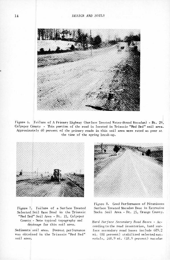
F i g u r e 6. F a i l u r e o f A P r i m a r y Highway ( S u r f a c e T r e a t e d Water-l-found Macadam) - R t . 29, Culpeper County - This p o r t i o n o f the road i s l o c a t e d i n T r i a s s i c "Red Bed" s o i l area. A p p r o x i m a t e l y 60 pe r c e n t o f the p r i m a r y roads i n t h i s s o i l area were r a t e d as poor a t
i j the time o f the s p r i n g break-up.
F i g u r e 7. F a i l u r e o f a Surface T r e a t e d S e l e c t e d S o i l Base Road i n the T r i a s s i c "Red Bed" S o i l Area - B t . 15, Culpeper County - Note t y p i c a l topography and
drai n a g e f o r t h i s s o i l area.
Sediments s o i l area. Poorest performance was o b t a i n e d i n t h e T r i a s s i c "Red Bed" s o i l area.
F i g u r e 8. Good Performance o f Bituminous Surface T r e a t e d Macadam Base i n E x t r u s i v e Hocks S o i l Area - R t . 15, Orange County.
Hard Surface Secondary Road Bases - Acc o r d i n g t o the road i n v e n t o r i e s , hard surf a c e secondary r o a d bases i n c l u d e 689.2 mi. (80 p e r c e n t ) s t a b i l i z e d s e l e c t e d mate r i a l s , 160.9 mi. (18.9 p e r c e n t ) macadam
SHELBURNE AND MANER - SPRING BREAK-UP IN VIRGINIA 15
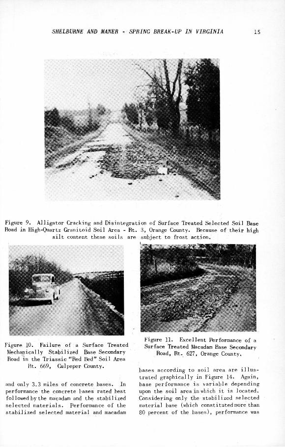
F i g u r e 9. A l l i g a t o r C r a c k i n g and D i s i n t e g r a t i o n o f S u r f a c e T r e a t e d S e l e c t e d S o i l Base Road i n High-Quartz G r a n i t o i d S o i l Area - R t . 3, Orange County. Because o f t h e i r h i g h
s i l t c o n t e n t these s o i l s are s u b j e c t t o f r o s t a c t i o n .
F i g u r e 10. F a i l u r e o f a Surface T r e a t e d M e c h a n i c a l l y S t a b i l i z e d E5ase Secondary Road i n t h e T r i a s s i c "Red Bed" S o i l Area
Rt. 669, Culpeper County.
and o n l y 3.3 m i l e s o f c o n c r e t e bases. I n performance the c o n c r e t e bases r a t e d b e s t f o l l o w e d by the macadam and the s t a b i l i z e d s e l e c t e d m a t e r i a l s . Performance o f t h e s t a b i l i z e d s e l e c t e d m a t e r i a l and macadam
F i g u r e 11. E x c e l l e n t Performance o f a Surface T r e a t e d Macadam Base Secondary
Road, Rt. 627, Orange County.
bases a c c o r d i n g t o s o i l area a r e i l l u s t r a t e d g r a p h i c a l l y i n F i g u r e 14. A g a i n , base p e r f o r m a n c e i s v a r i a b l e d e p e n d i n g upon the s o i l area i n which i t i s l o c a t e d . C o n s i d e r i n g o n l y the s t a b i l i z e d s e l e c t e d m a t e r i a l base (which c o n s t i t u t e d more than 80 percent o f the bases), performance was

16 DESIGN AND SOILS
5 cr> o CO m o n o
in o o in —< M O o o
^ ro irt ro r- cm CN ro o ^
M CO 00 CM ^ r-
CM
CO o^ cn o o o
1̂1 \o m O o
r- CO o o in CO
o o ^ o o o o
O P - o o o o
o
r- «£) o O P-C4 fO
00 o o o o CM in
p i
S I
i J
l i s OS -* \0 tn
^0 O O O a^ 00
° S
o o o\ o
CM O O
o m o o o
o m o so o
Cs CO o o o o Oi
CO 00 O O C O
m o\ CM O o o
Cs O
CD CM sC CN
£̂> O O O O
O 00 O
r- CO d t-
CN CN O* CM
CO p-i OS
m vo o o r- CO ON vo O
*rt 00 O O CM CM ON d CM
OS ^ O O O O
1=1 " 1
« CM S i "
O O O o
CN r- o o
cn CM o o o o
O O 00 o rA O
^ a > a
1̂ 1^ adXx a D r j j n g

SHELBVRNE AND MANER - SPRING BREAK-UP IN VIRGINIA 17
F i g u r e 12. D i s t r e s s o f a Sur f a c e T r e a t e d M e c h a n i c a l l y S t a b i l i z e d Fase Secondary
Road - R t . 609, Culpeper County.
1 COASTAL PLAIN HIGH QUARTZ LOW QUARTZ EXTRUSIVE TRIASSIC
SeOlMEMTS GRAMITOIOS GRflMITOIOS ROCKS "RED fl E QS"
B A S E - N A T U R A L SOI L , G R A V E L . E T C .
L E G E N D 1 I R A T I N G S 1 a 2 - G O O D
^ ^ R A T I N G 3 - F A 1 R
^ • R A T I N G S 4 a 5 - P O O R
COASTAL fLArH HI6H OUARTZ LOW QUART! StOIMENTS 6RANITOI0S GRANITOIDS
B A S E - M A C D A M
F i g u r e 13. P r i m a r y Road Performance by Fase Types.
b e s t i n t h e C o a s t a l P l a i n and p o o r e s t i n the T r i a s s i c s o i l area.
Primary Road Surfaces - P r i m a r y road s u r faces are c l a s s i f i e d i n t o t h r e e t y p e s by
L E G E N D CZI R A T I N G S I a 2 - G O O D ^ R A T i M G 3 — F A I R M R A T I N G S 4 a 5 - P 0 0 R
COASTAL PLAIN HIGH QUARTZ LOW QUARTZ EXTRUSIVE TRIA SEDIMENTS BRANITOIDS GRANITOIDS ROCKS "RCO
B A S E - S T A B l L I Z E b - S E L E C T E O M A T E R I A L S
I0( —
90 —
EXTRUSIVE RED BEDS-
B A S E - M A C A D A M
F I G U R E 14
SECONDARY ROAD PERFORMANCE BY BASE TYPES
F i g u r e 14. Secondary Road performance by Base Types.
the road i n v e n t o r y , namely s u r f a c e t r e a t ment (77.4 p e r c e n t ) , b i t u m i n o u s p l a n t mix (20.6 p e r c e n t ) , and p o r t l a n d cement conc r e t e (2.0 p e r c e n t ) . A l l c o n c r e t e s u r f a c e s were r a t e d good i n p e r f o r m a n c e . B i t u m i n o u s p l a n t mix s u r f a c e s were gene r a l l y good and 82.7 per c e n t o f them were so r a t e d . Only th o s e t h a t were 8 o r 10 y r . o l d and i n need o f a s e a l c o a t r a t e d f a i r o r p o o r . A b o u t o n e - t h i r d o f t h e bitu m i n o u s s u r f a c e t r e a t m e n t s r a t e d good, w h i l e 38.6 p e r c e n t were c l a s s i f i e d as p o o r . F i g u r e 15 i l l u s t r a t e s p e r f o r mance o f p l a n t mix and s u r f a c e t r e a t m e n t .
Secondary Road Surfaces - W h i l e t h e s u r f a c e s o f s e c o n d a r y r o a d s were o f f o u r t y p e s , l i g h t s u r f a c e t r e a t m e n t s p r e dominate s i n c e 98.7 p e r c e n t were o f t h i s c a t e g o r y . Performance i n t h e f i v e gene r a l s o i l a r e a s i s i l l u s t r a t e d by F i g ure 16.
To f u r t h e r i l l u s t r a t e t h e c o r r e l a t i o n o f r oad performance w i t h s o i l areas F i g ure 17 has been p r e p a r e d . The t o p port i o n shows t h a t p r i m a r y road performance i s b e s t i n t h e C o a s t a l P l a i n S e diments and p o o r e s t i n t h e T r i a s s i c "Red B e d "

18 DESIGN AND SOILS
L E G E N D C D R A T I N G S 1 a 2 - G O O O
R A T I N G 3 - F A I R
R A T I N G S 4 a S - P O O R
n
COASTAL PLUM HIOM QUARTZ LOW OUARTZ CEDIMCNTS ORANITOIDS ORAHITOIDt
S U R F A C E - S U R F A C E T R E A T M E N T
COAtTAL PLAIN KIOH flUARTZ LOW OUARTZ CXTIIUOIve TDIAStlO • lOIMZMTO OKADITOIOS ORAMlTOlOB ROOKt 'RED 0 1 0 1 '
S U R F A C E — P L A N T M I X
Figure 15. Primary Road Performance by Surface Types.
s o i l s area. I n ge n e r a l , t h i s i s f u r t h e r emphasized by the lower graphs.
SUMMARY OF RESULTS
Based upon the performance data obtained a t the time o f the s p r i n g break-up on more t h a n 1000 mi. o f p r i m a r y and n e a r l y 5000 mi. o f s e c o n d a r y roads m Culpeper D i s t r i c t , the f o l l o w i n g l e s u l t s have been summarized under a p p r o p r i a t e headings.
Primary Roads
1. The break-up of t h i s past s p r i n g of primary roads i n the Gilpeper D i s t r i c t was more severe than that for the e n t i r e s t a t e . A comparison of primary highways i n each performance r a t i n g i s as follows:
P e r f o r m a n c e C u l p e p e r E n t i r e R a t i n g D i s t r i c t
% S t a t e
%
Good 43 58 F a i r 23 23 Poor , 29 18 Under C o n s t . 5 1
L E G E N D CZI R A T I N G S 1 a 2 - G O O D
100 R A T 1 N G 3 - F A I R
K — ^ 1 R A T I N G S 4 a 9 - P O O R
CO —
10 —
EITRUaiVI TRIAS8I0 "RED 8E0B
COASTAL PLAIN HIOH OUARTZ LOV QUAHn aCDIHCNTS ORANITOIDS 8RARIT0ID8
S U R F A C E - L I G H T S U R F A C E T R E A T M E N T
Figure 16. Secondary Road Performance by Surface Types.
L E G E N D Z Z D R A T I N G S I a 2 - G O O D
R A T I N G 3 - F A I R
m m R A T I N G S 4 8 5 - P O O R
HIOH OUARTZ LOW OUARTZ ORANITOIDS ORANITOIDS
I S O I L A R E A S — P R I M A R Y R O A D S
- 1 "11 t
I , ..™ I.VN ailARlZ KXTRUOIVE TRIAfOlO
• COIMCirrs ORANITOIOO OOANITOIOB ROOMS ' R I D BIOS '
S O I L A R E A S - S E C O N D A R Y R O A D S
Figure 17. Primary and Secondary Road Performance by S o i l Areas.
2. Primary road performance was v a r i able, depending upon the design (base and s u r f a c e type) and the s o i l area i n which the road was located.
3. The o r d e r of r a t i n g the p e r f o r mance o f bases from b e s t t o . t h e p o o r e s t was as follows: (1) Portland cement conc r e t e , ( 2 ) soil-cement, ( 3 ) macadam, ( 4 ) s t a b i l i z e d s e l e c t e d m a t e r i a l s and ( 5 ) n a t u r a l s o i l s , g r a y e ] , s t o n e , e t c . I t

SHELBURNE AND MANER - SPRING BREAK-VP IN VIRGINIA 19
hould be pointed out, however, that only ine soil-cement p r o j e c t , 6.8 mi. i n length 'as a v a i l a b l e for t h i s conparison.
4. C o n s i d e r i n g the bituminous s u r -•aces which comprise 98 p e r c e n t o f the )rimary road s u r f a c e s i n the d i s t r i c t , t h e )erformance o f bituminous p l a n t mix was Car s u p e r i o r to t h a t of or d i n a r y s u r f a c e treatment.
5. Hie study emphasized the importance )f the general s o i l area as a major v a r i -i b l e i n road performance. Considering a l l :he primary roads, the l e a s t amount of i i s t r e s s was found i n the C o a s t a l P l a i n Sediments and the most was evident i n the f r i a s s i c "Red Bed" s o i l area.
Secondary Roads 6. Survey r e s u l t s a l s o show t h a t the
spring break-up was more severe on secondary roads i n the Culpeper D i s t r i c t than f o r the e n t i r e s e c o n d a r y system m the s t a t e . T h i s statement i s based upon the following comparison:
SECXXVDARY ROAD PERFORMANCE
P e r f o r m a n c e R a t i n g
Good F a i r P oor Under C o n s t .
C u l p e p e r D i s t r i c t
% 19 33 47 1
E n t i r e S t a t e
( 8 D i s t r i c t s ) %
33 29 37 1
I t should be emphasized that a greater percentage of T r i a s s i c "Red Bed" s o i l area i s l o c a t e d i n the Culpeper D i s t r i c t than i n the e n t i r e s t a t e and t h i s probably i s l a r g e l y r e s p o n s i b l e for the d i f f e r e n t i a l performance.
7. The hard s u r f a c e secondary roads performed s l i g h t l y b e t t e r than the non-hard s u r f a c e ones as shown below:
P e r f o r m a n c e R a t i n g
Good F a i r P o o r
H a r d S u r . %
27 26 47
Non-Hard S u r .
18 35 47
8. As i n the case of primary highways.
secondary road performance a l s o v a r i e d with the design (base and surface type) as w e l l as the s o i l area.
9. Tlie order of r a t i n g secondary road bases from best to poorest i n the Culpeper D i s t r i c t was a s f o l l o w s : c o n c r e t e , macadam and s t a b i l i z e d s e l e c t e d m a t e r i a l . More t h a n 80 p e r c e n t o f h a r d s u r f a c e secondary road bases i n the d i s t r i c t were of the l a t t e r type.
10. W h i l e i n s u f f i c i e n t d a t a were a v a i l a b l e for c o n c l u s i v e comparisons, i t was i n d i c a t e d t h a t heavy s u r f a c e treatments r e s u l t e d i n b e t t e r performance than l i g h t s u r f a c e treatments.
General 11. The survey revealed that the high
e r t he c l a s s or type o f pavement the be t t e r the performance.
12. A study of weather records r e v e a l ed that pavement break-ups are most severe fo r those w i n t e r s w i t h low temperatures preceded by subgrade and base s a t u r a t i o n ( h i g h p r e c i p i t a t i o n ) . The pa s t w i n t e r was second only to that of 1935-36 as to c l i m a t i c conditions favorable f o r a severe break-up.
13. "Die f i e l d s t u d i e s throughout the s t a t e emphasized the importance o f adequate p r o v i s i o n s f o r d r a i n a g e i f good road performance i s to be s e c u r e d . I n cases o f f l a t topography i t was i n d i c a t e d t h a t improved performance can be secured by the use of a high l e v e l p r o f i l e .
14. One o f the most important r e s u l t s of the survey was the c o r r e l a t i o n of road performance with s o i l area. T h i s suggests t h a t d e s i g n and c o n s t r u c t i o n p r a c t i c e s should be v a r i e d with t h i s important item.
cowausiONS
I n conclusion, road condition surveys, i f made a t a time o f a s e v e r e s p r i n g break-up, are a p r a c t i c a l means of securing information on the extent of d i s t r e s s and can be used s u c c e s s f u l l y i n e v a l u a t i n g f a c t o r s a f f e c t i n g performance. Data from such surveys can a l s o be used m conjunct i o n with maintenance or r e c o n s t r u c t i o n programs and for formulating p o l i c i e s r e garding design and c o n s t r u c t i o n p r a c t i c e s .

20 DESIGN AND SOILS
ACKNOWLEDGEMENTS
The w r i t e r s w i s h t o e x p r e s s t h e i r app r e c i a t i o n to t h e l a r g e number o f i n d i v i d u a l s who have a s s i s t e d from time t o time i n v a r i o u s p h a s e s o f t h e s t u d i e s . E s p e c i a l t h a n k s a r e d u e Mr. C. S. M u l l e n , C h i e f E n g i n e e r , f o r h i s f o r e s i g h t i n i n
i t i a t i n g t h e s t u c i y and f o r h i s i n t e r e s i n t h e d a t a s e c u r e d . Mr. A. W. F u r g i u e l e C u l p e p e r D i s t r i c t M a t e r i a l s E n g i n e e r , i i t o be commanded f o r h i s p a i n s t a k i n g an( e f f i c i e n t manner o f s e c u r i n g and r e p o r t i n i t h e f i e l d d a t a . P r a c t i c a l l y a l l o^ t h t p e r s o n n e l o f t h e R e s e a r c h S e c t i o n hav< c o n t r i b u t e d i n one way o r a n o t h e r t o th« r e p o r t .