Embed Size (px)
Citation preview
Appendix 1 1–1
Appendix 1. Ottauquechee River and Reservoir Brook Flood Inundation Maps of the 1-Percent Annual Exceedance Probability (100-Year) Flood and Flood of Tropical Storm Irene in Woodstock, Bridgewater, Sherburne, and Plymouth, Vermont
Figures 1–1. Index map showing the extents of the flood inundation maps for the Ottauquechee
River and Reservoir Brook, Vermont, (figs. 1–2 through 1–4) ........................................... 1–2 1–2. Map showing flood inundation on the Ottauquechee River and Reservoir Brook,
Vermont, and the locations of cross sections and U.S. Geological Survey streamgage 01150900 Ottauquechee River near West Bridgewater, Vt., in Plymouth and Sherburne and parts of Bridgewater, Vt. ................................................... 1–3
1–3. Map showing flood inundation on the Ottauquechee River, Vermont, and the locations of cross sections in Bridgewater, Vt ................................................................... 1–4
1–4. Map showing flood inundation on the Ottauquechee River, Vermont, and the locations of cross sections in Woodstock, Vt ..................................................................... 1–5
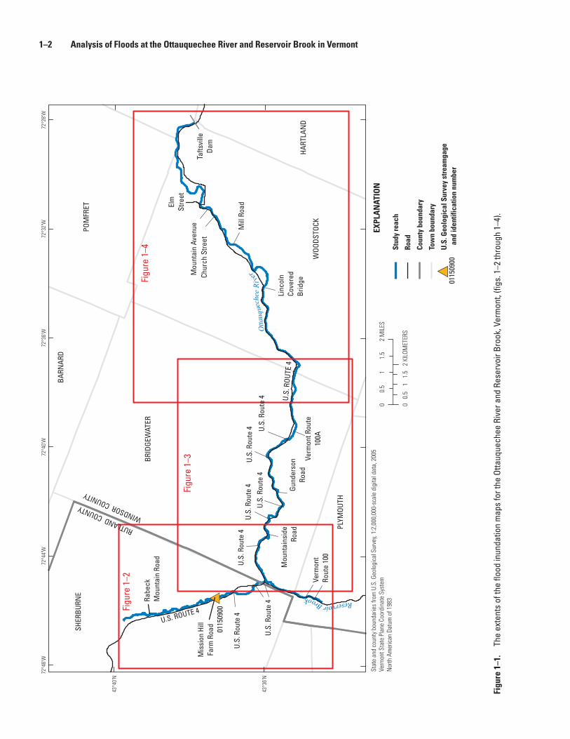
1–2 Analysis of Floods at the Ottauquechee River and Reservoir Brook in Vermont
BRID
GEW
ATER
SHER
BURN
E
BARN
ARD
POM
FRET
WOO
DSTO
CK
PLYM
OUTH
HART
LAN
D
Verm
ont
Rout
e 10
0
Tafts
ville
Dam
Elm
Stre
et
Mou
ntai
n Av
enue
Chur
ch S
treet
Mill
Roa
d
Linc
oln
Cove
red
Brid
ge
U.S.
Rou
te 4
Verm
ont R
oute
100A
Gund
erso
nRo
ad
U.S.
Rou
te 4
U.S.
Rou
te 4
U.S.
Rou
te 4
U.S.
Rou
te 4
U.S.
Rou
te 4
Mou
ntai
nsid
eRo
ad
U.S.
Rou
te 4
Mis
sion
Hill
Farm
Roa
d
Rabe
ck
Mou
ntai
n Ro
ad
RUTLAND COUNTYWINDSOR COUNITY
U.S.
ROU
TE 4
U.S. ROUTE 4
0115
0900
Otta
uque
che e
Riv
er
Reservoir BrookFi
gure
1–2
Figu
re 1
–4
Figu
re 1
–3
72°2
8'W
72°3
2'W
72°3
6'W
72°4
0'W
72°4
4'W
72°4
8'W
43°4
0'N
43°3
6'N
01
0.5
1.5
0.5
1.5
2 M
ILES
01
2 KI
LOM
ETER
S
EXPL
AN
ATIO
N
U.S
. Geo
logi
cal S
urve
y st
ream
gage
an
d id
entif
icat
ion
num
ber
0115
0900
Stat
e an
d co
unty
bou
ndar
ies
from
U.S
. Geo
logi
cal S
urve
y, 1:
2,00
0,00
0-sc
ale
digi
tal d
ata,
200
5Ve
rmon
t Sta
te P
lane
Coo
rdin
ate
Syst
emN
orth
Am
eric
an D
atum
of 1
983
Road
Stud
y re
ach
Coun
ty b
ound
ary
Tow
n bo
unda
ry
Figu
re 1
–1.
The
exte
nts
of th
e flo
od in
unda
tion
map
s fo
r the
Otta
uque
chee
Riv
er a
nd R
eser
voir
Broo
k, V
erm
ont,
(figs
. 1–2
thro
ugh
1–4)
.
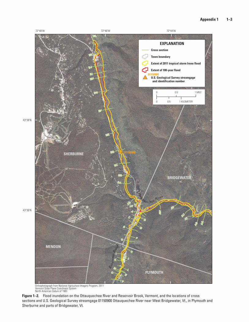
Appendix 1 1–3
# 01150900
P
N
MO
L
K J
IH
G F
E D
CB
A
ARAS
AT
AU
AV
AW
AYAZ
BA
BB
BC
BD
BE
BF
BG
BHBI
BJ
BK
BL
R
eser
voir
Bro o
kOttauque c hee River
72°44'W72°46'W72°48'W
43°38'N
43°36'N
EXPLANATION
U.S. Geological Survey streamgage and identification number
Cross section
Town boundary
Extent of 2011 tropical storm Irene flood
Extent of 100-year flood
BRIDGEWATER
PLYMOUTH
SHERBURNE
MENDON
0 0.5 1 MILE
0 0.5 1 KILOMETER
01150900
Orthophotograph from National Agriculture Imagery Program, 2011Vermont State Plane Coordinate SystemNorth American Datum of 1983
Figure 1–2. Flood inundation on the Ottauquechee River and Reservoir Brook, Vermont, and the locations of cross sections and U.S. Geological Survey streamgage 01150900 Ottauquechee River near West Bridgewater, Vt., in Plymouth and Sherburne and parts of Bridgewater, Vt.
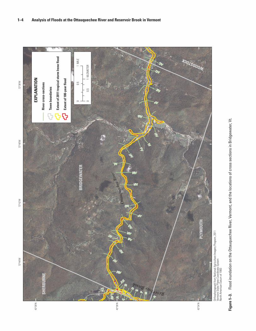
1–4 Analysis of Floods at the Ottauquechee River and Reservoir Brook in Vermont
AZ
AY
AX
AW
AV
AU
ATAS
AR
AQ
AP
AO
AN
AM
AL
AK
AJ
AI
AH
AG
AF
AE
AD
AC
H
GFED
CB
A
Reservoir Brook
Otta
uque
chee
Rive
r
72°3
8'W
72°4
0'W
72°4
2'W
72°4
4'W
43°3
8'N
43°3
6'N
43°3
4'N
EXPL
AN
ATIO
N
Rive
r cro
ss-s
ectio
ns
Tow
n bo
unda
ries
Exte
nt o
f 201
1 tr
opic
al s
torm
Iren
e flo
od
Exte
nt o
f 100
-yea
r flo
od
WOODSTOCK
BRI
DG
EWAT
ER
PLYM
OU
TH
SHER
BU
RNE
01
0.5
MIL
E
01
0.5
KILO
MET
ER
Orth
opho
togr
aph
from
Nat
iona
l Agr
icul
ture
Imag
ery
Prog
ram
, 201
1Ve
rmon
t Sta
te P
lane
Coo
rdin
ate
Syst
emN
orth
Am
eric
an D
atum
of 1
983
Figu
re 1
–3.
Floo
d in
unda
tion
on th
e Ot
tauq
uech
ee R
iver
, Ver
mon
t, an
d th
e lo
catio
ns o
f cro
ss s
ectio
ns in
Brid
gew
ater
, Vt.
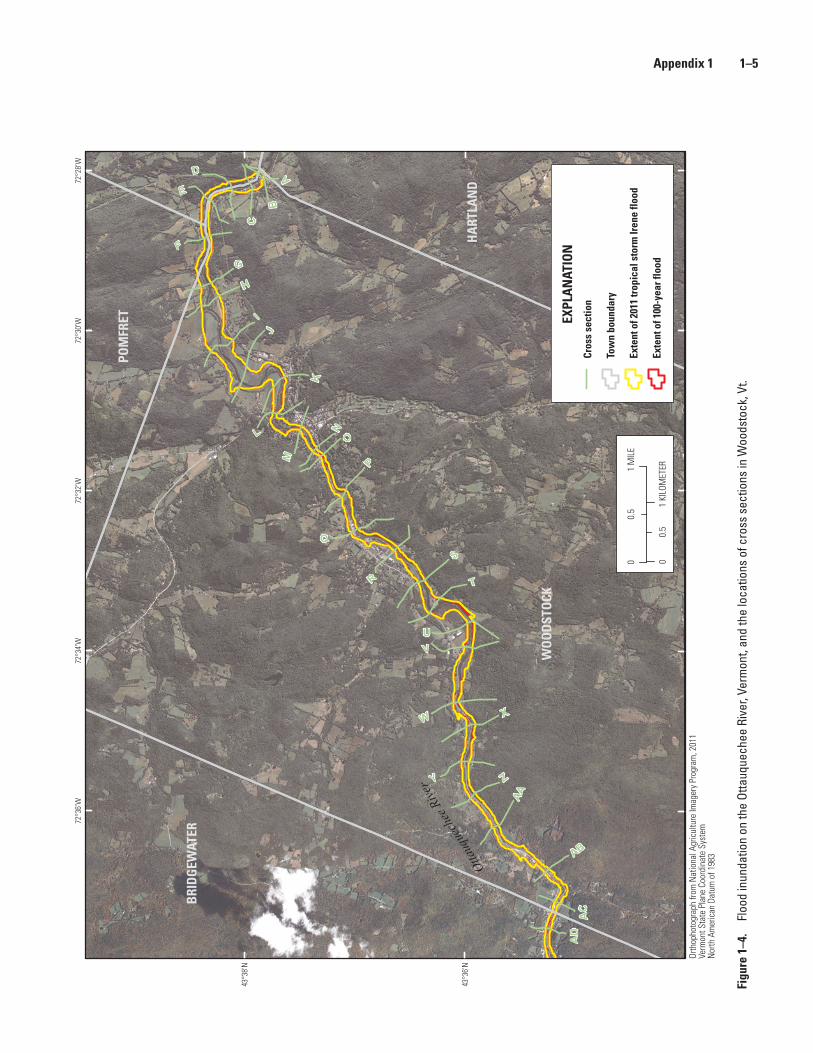
Appendix 1 1–5
ZY
XW
VU
T
S
R
Q
P
O
N
M
L
K
JI
H
G
F
E
D
C
BA
AA
AB
AC
AD
Ottauq
uech
ee R
iver
72°2
8'W
72°3
0'W
72°3
2'W
72°3
4'W
72°3
6'W
43°3
8'N
43°3
6'N
EXPL
AN
ATIO
NCr
oss
sect
ion
Tow
n bo
unda
ry
Exte
nt o
f 201
1 tr
opic
al s
torm
Iren
e flo
od
Exte
nt o
f 100
-yea
r flo
od
WO
OD
STO
CK
BRI
DG
EWAT
ER
HA
RTLA
ND
POM
FRET
00.
51
MIL
E
00.
51
KILO
MET
ER
Orth
opho
togr
aph
from
Nat
iona
l Agr
icul
ture
Imag
ery
Prog
ram
, 201
1Ve
rmon
t Sta
te P
lane
Coo
rdin
ate
Syst
emN
orth
Am
eric
an D
atum
of 1
983
Figu
re 1
–4.
Floo
d in
unda
tion
on th
e Ot
tauq
uech
ee R
iver
, Ver
mon
t, an
d th
e lo
catio
ns o
f cro
ss s
ectio
ns in
Woo
dsto
ck, V
t.