Embed Size (px)
Citation preview
ANALYSIS AND MAPPING OF BASIC COMMUNAL LAND ADMINISTRATION
SYSTEMS USING PARTICIPATORY GPS AND GIS:
A CASE STUDY OF MAKURUNG VILLAGE
by
MAMPONE MORRIS MALEKA
Submitted in partial fulfillment of the academic requirements for the degree of
Master of Environment and Development (Land Information Management)
Centre for Environment, Agriculture and Development,
University of KwaZulu-Natal, Pietermaritzburg
2006

ABSTRACT
Participatory GPS and GIS mapping is a mapping process that involves active
participation of the local communities with the assistance of outsiders who are
experts in the field. The objective of Participatory GPS and GIS mapping is to
produce a technically accurate and socially acceptable participatory map and to
facilitate skills transfer to the participant community.
A basic communal land administration system is a land administration structure
responsible for the administration of a local, elementary area of jurisdiction (a
village) occupied by a tribe whose rights to land are derived from shared rules
determining access and is normally led by an Induna. The analysis of such a
structure could provide a foundation for the implementation of Communal Land
Rights Act, 2004 (Act No 11 of 2004) that is, the transfer of communal lands to
communities.
A sub-metre accuracy is obtainable after post-processing differential correction
as acclaimed by Trimble on the Geo-XT™ GPS unit and proven in the Ukulinga
case study.
Pa rticipatory GPS and GIS mapping guarantees effective and efficient skills
transfer to participant communities and accurate recording of boundary data.
Maps produced through Participatory GPS and GIS mapping are widely
acceptable since they are preceded by discussions and subsequent consensus
on boundary data points prior to actual recording, thereof.
The study was designed to analyze basic communal land administration systems
and to develop a methodology for mapping them. A successful implementation of
the Communal Land Rights Act, 2004 required spatial and related information on
land administration structures A Participatory mapping methodology designed
was tested in two case studies and found to be reasonably accurate.
\\

DISCLAIMER
This mini-dissertation represents the original work of the author and has not been
submitted in any form for any degree or for any other purpose at any university or
institution of higher learning. Where use has been made of work by other authors, it is
duly acknowledged in the text.
Dr. D. RUGEGE
SUPERVISOR
III
-3/o q(01-DATE
\.lctOlf\~tDATE

ACKNOWLEDGEMENTS
My sincere thanks and gratitude goes to the following people and institutions
for their positive contribution to my studies
• Dr. 0 Rugege, my mentor, for providing academic leadership 'par
excellence' and support throughout the course. He voluntarily availed
his high-tech GPS equipment and physically oversaw the data
collection exercise. Without his assistance this study would have
remained a yet to be realized dream. Many thanks.
• The Department of Land Affairs for awarding me a bursary and their
vision to buy into the program
• Craven and Brice at the Geography Department, UKZN, for assisting
me with map production
• Sam MabotJa for brainstorming sessions and encouragement
• Zandile Nzimande for her support and encouragement when the going
was really tough.
• My parents for guiding me from childhood to adulthood.
• My wife Modiegi, children Masoto, Ofentse and Tsheamo for their
support, encouragement and the sacrifice of being without Daddy
during my study period.
IV

CONTENTS
Abstract ii
Disclaimer iii
Acknowledgements iv
Contents v
List of Figures x
List of Tables xi
Abbreviations xii
Glossary xiii
1. BACKGROUND 11.1 Introduction................ . 1
1 2 Problem Statement........................ 2
1 3 Research Objectives..... . 3
1A Research Questions........ 3
2. LITERATURE REViEW 4
LAND ADMINISTRATION SYSTEMS 4
2.1 Background to Communal Land Administration in Africa 4
2.2 Communal Land Administration Systems in South Africa 7
2.3 Legislative Framework ... 8
2 4 The Role of Communal Land Rights Act, 2004 (Act 11 of 2004) in
Communal Land Administration....... . 9
2.5 The l\Jeed for Mapping Communal Land Administration Systems .10
2 6 Description of Existing Communal Land Administration Structures ... 13
2.7 Challenges Associated with the System of Communal Land
Administration. . 14
\ .

PARTICIPATORY GPS AND GIS 14
2.8 Scientific and Technical Principles of GPS 14
2.8.1. Sources of GPS Error 15
a) Satellite Geometry....... . .. . 15
b) Ionosphere.......... . 16
c) Troposphere... .. 17
d) Multipath Errors .. 17
e) Ephemeris Errors... 17
f) Clock Errors. 17
2.8.2. Methods of Improving Accuracy 18
a) Correcting Ionospheric Errors 18
b) Correcting Tropospheric Errors .............18
c) Correcting Multipath Errors 19
d) Correcting Ephemeris Errors............ . 19
2.9 Real- Time Differential GPS ..19
2.10 Post - Processing Differential GPS......... . .. 20
2.11 Basic Skills Requirements in Operating GPS and GIS 21
2.12 Legal Requirements of GPS Accuracy in Land Surveying....... ..22
2.13 Conventional Survey and GPS Surveying Techniques 24
2.14 The Significance of Participatory GPS-based Mapping of Communal
Land Administration Boundaries......... 25
3. PARTICIPATORY GPS-BASED MAPPING OF UKULlNGA 28
3.1 Introduction........... 28
3.2 The Study Area 28
3.3 Participatory GPS Mapping Methodology........... . 30
4. PARTICIPATORY GPS-BASED MAPPING RESULTS OF
UKULINGA 32
4 1 Introduction... .. 32
42 Accuracy of GPS Measured Trigonometric Beacon Parameters.. . 33
Vl

... 39
42
42
4 3 Accuracy of Area Derived from GPS Measured Boundary Markers ... 36
5. ANALYSIS AND MAPPING OF BASIC COMMUNAL LAND
ADMINISTRATION SYSTEMS 39
5 1 Introduction..... .. . 39
5 2 The Study Area......... 39
5.3 Mapping with Global Positioning Systems (GPS) and Geographic
Information Systems (GIS).. .
54 Interviews .. ..
5. 5 Analysis.. . .. '" .
6. DATA ANALYSIS: MAPPING OF BASIC COMMUNAL LAND
ADMINISTRATION SYSTEMS 43
6.1 Introduction..................... 43
6.2 Interview Data: Makurung Land Administration Team 43
6.2.1 Land Allocation Procedures 43
6.2.2 Recording of Land Rights... 44
6.2.3 Transfer of Land Rights................... ..45
6.24 Challenges Facing Makurung Land Administration System. 46
6.3 Bakgaga Traditional Authority............. . 47
6.3.1 Introduction 48
6.3.2 The Hierarchical Structure of Bakgaga Traditional Authority's
Land Administration System.......... ..48
(a) The Chief or Chieftainess .. 48
(b) Senior Mokgomana . 49
(c) Tribal Secretary. .................49
(d) Bakgomana . 49
(e) Tribal Council. . 50
(f) Tribal Treasurer 50
(g) Tribal Court.. "............... 50
(h) Induna '" 50
\J I

(i) Induna's family.. . 51
U) Induna's Assistants (Bathusi ba Ntona) 51
(k) Secretariat (Bangwaledi) .. 51
(I) Kgoro (Community members).. 51
6.4 Analysis of Interview Responses.................................... 53
64.1 Land Allocation Procedures.... . 54
6.4 2 Comparative Analysis of the Role Played by Communal Land
Administration System and that to be Played by the Envisaged
Land Administration Committee.... . 56
64.3 Analysis of the Structural Composition of Communal Land
Administration System against Land Administration Committee
Envisaged by CLaRA .. .. 56
6.4.4 Decision Making Processes... 57
6.4.5 Community Rules Development Process 58
64.6 Recording of Land Rights .. 59
64.7 Role Played by Gender in Land Allocation ...60
6 5 GPS RECORDINGS OF BOUNDARY DATA........ . 61
6 5.1 Mapping Makurung With Global Positioning System (GPS) 61
6.6 ANALYSIS OF GPS RECORDINGS OF BOUNDARY DATA 65
6.6.1 Identification of Boundaries of Basic Communal Land
Ad ministration Area............. 65
6.6.2 Accuracy of GPS Recordings 66
6.6.3 Data Processing in GIS 66
7 CONCLUSION 69
7.1 Introduction . ... 69
7.2 Defining Boundaries and Developing Participatory GPS-Based
Methodology for Identifying and Mapping Communal Land
Administration Boundaries.... 69
7 3 Understanding of Existing Land Administration Structure and
Systems..................................... ... 70
\ III

7 4 Achievements of the Study. .. 71
8 RECOMMENDATIONS 73
REFERENCES 74
Appendix 1
Appendix 2
Appendix: 3
Appendix 4.
83
........................................ 84
..... 85
86
1.\

LIST OF FIGURES
Figure l' Perceived Spatial Data Model for a Generic CLaRA
Implementation Cycle 12
Figure 2 The Ukulinga Research Farm Cadastral Boundary Overlain on a
Topographic Map 29
Figure 3 Participatory GPS-based Mapping Flowchart of the Ukulinga
Research Farm....................................... 31
Figure 4 Ukulinga Farm Boundary Derived from GPS Captured Points
Against an Ortho-rectified Arial Photograph Backdrop 38
Figure 5 Flowchart: GPS-based Mapping Operations of Land
Administration Systems in a GIS... . 41
Figure 6 A Graphic Representation of Makurung Land Administration
System Responsible for Makurung Village, gaMphahlele,
Limpopo Province 46
Figure 7: Hierarchical Structural Representation of Bakgaga Traditional
Authority. . 52
Figure 8 Makurung Raw Data Map . ......... 67
Figure 9 Final Participatory Map Basic Communal Land Administration
Area (red boundary line)........ 68
..37
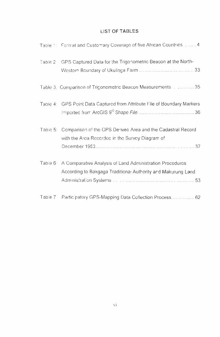
LIST OF TABLES
Table 1. Formal and Customary Coverage of five African Countries 4
Table 2 GPS Captured Data for the Trigonometric Beacon at the North-
Western Boundary of Ukulinga Farm 33
Table 3 Comparison of Trigonometric Beacon Measurements 35
Table 4 GPS Point Data Captured from Attribute File of Boundary Markers
®Imported from ArcGIS 9 Shape File........ 36
Table 5: Comparison of the GPS Derived Area and the Cadastral Record
with the Area Recorded in the Survey Diagram of
December 1953.
Table 6: A Comparative Analysis of Land Administration Procedures
According to Bakgaga Traditional Authority and Makurung Land
Administration Systems..... .. . 53
Table 7 Participatory GPS-Mapping Data Collection Process 62
\1

ABBREVIATIONS
BTA - Bakgaga Traditional Authority
CLaRA - Communal Land Rights Act, 2004 (Act No 11 of 2004)
GIS - Geographical Information System
GPS - Global Positioning System
IPILRA - Interim Protection of Informal Land Rights Act, 1996 (Act No.31 of
1996)
Interim Procedures - Interim Procedures Governing Land Development
Decisions which Require the Consent of the Minister
of Land Affairs as Nominal Owner of the Land
PTO - Permission to Occupy
\.1 I

GLOSSARY
Induna IS a traditional leader who is under the authority of, or exercises
authority within the area of jurisdiction of, a Chief or Chieftainess in
accordance with customary law.
Chief is a traditional leader under whose authority or within whose area of
jUrisdiction an Induna exercises authority In accordance with customary law.
Chieftamess is a female counterpart of Chief.
Kgoshigadi a Sepedi word for the Chieftainess.
Geographical Information Systems (GIS), Hastings (2005), represent a class of
software systems used with spatially distributed data and organised around
similar geographical data-object and attribute structures.
Land tenure IS the nature and range of rights that individuals have to land,
water and other natural resources in relation to rights exercised by individuals,
groups and the state (Torhonen 2003).
Customary land is land held in accordance with customary law (Rusanen
2005)
Customary tenure is land held under customary laws, and governed by
traditional rules and regulations (Obala and Kinyungu 2005)
Global Positioning System (GPS) is a worldwide radio-navigation system
formed from constellation of 24 satellites and their ground stations
(htt ://www.trible.com/s/whathtml)
\111

Royal family means the core customary institution or structure consisting of
Immediate relatives of the ruling family within a traditional community.
(Traditional Leadership and Governance Framework Act, 2003 (Act 41 of
2003))
Senior Mokgomana is the Chief or Chieftainess' assistant.
Bakgomana are the Chief or Chieftainess appointed councilors who assist in
the administration of the tribal authority.
Mokgomana refers to singularity of the term Bakgomana.
Senior Mokgomana is the Sepedi phrase for Chief Induna.
Kgoro is a tribal or community meeting called by the Chief or Chieftainess or
Induna where wide range of issues of interest to the tribe is discussed .
.';IV
1. BACKGROUND
1.1. Introduction
The Communal Land Rights Act, 2004 (Act NO.11 of 2004) (CLaRA) presents to
Indigenous communities both the challenge and opportunity to map their communal
land administration boundaries. Traditional survey(s) which require(s) technical
knowledge to undertake, more time to accomplish and costly to commission are being
rejected In favour of modern GPS and GIS operations. Currently there is movement
towards participatory mapping; benefits thereof overwhelming the disadvantages.
It is the objective of this study to analyze basic Communal Land Administration
Systems, and develop a participatory GPS-based methodology that could form a
foundation for identifying and mapping communal land administration boundaries.
AnalysIs of basic Communal Land Administration Systems is crucial to take stock of
the available structures and their functioning to support the implementation phase of
CLaRA The South African government intends to transfer communal land in
ownership to communities. It therefore becomes necessary to develop a user-friendly
model that would assist communities to identify and map the boundaries of their
communal lands.
Through this study an analysis of a Basic Communal Land Administration System and
a Participatory GPS-based methodology for mapping communal land administration
boundaries is presented

1.2. Problem Statement
From time immemorial, indigenous people stayed together in communes with each
household enjoying exclusive rights to designated areas while enjoying common
usufruct rights to other portions of land such as the pastures, wood lots and water
sources/points Indigenous people were governed by traditional leaders through
customary law (Marongwe, 2003) Colonial conquest of the indigenous people
gave rise to major disruptions of the administrative practices of the indigenous
people Repressive laws were introduced to undermine, humiliate and dehumanize
indigenous people.
The Black Administration Act, 1927 (Act No. 38 of 1927), the Development Trust
and Land Act, 1936 (Act No. 18 of 1936), the Black Authorities Act, 1951 (Act No.
68 of 1951) and the Black Areas Land Regulations, 1969 (R188 of 1969) modified
the substance and content of the role of traditional leaders and institutions in land
administration (Sibanda, 2006) The indigenous customary systems of land
administration were changed to suit the needs and interests of the colonial political
economy
The Communal Land Rights Act, 2004 (Act NO.11 of 2004) (CLaRA) intends to
transfer communal land to communities and to establish democratic land
administration structures to administer communal land. It is necessary to take
stock of existing land administration structures and understand how they function.
Insight into existing structures informs the way forward.
This study analyses and develops tools for mapping basic Communal Land
Administration Systems using Participatory GPS and GIS. Prior to mapping
communal land the extent of the communal area has to be defined by the
community. The study presents a generic process to follow in obtaining information
from the community defining the boundaries of their land area and presents the
output in the form of community developed map

1.3. Research Objectives
• To analyze basic Communal Land Administration Systems
• To develop a participatory GPS-based methodology for identifying and
mapping communal land administration boundaries.
1.4. Research Questions
The following research questions are pursued in this study
• What land allocation and administration structures and systems exist in
communal areas?
• How are boundaries of a basic communal land administration defined?

2. LITERATURE REVIEW
LAND ADMINISTRATION SYSTEMS
2.1. Background to Communal Land Administration in Africa
Land Administration in Africa, Augustinus (2003), consists of the conventional land
administration systems based on land registration and; customary and/or informal
land administration systems. The majority of African countries' populations use the
customary land administration system, especially in rural areas. Colonial land
administration laws remain entrenched In many African countries today
(Augustinus, 2003). The predominant tenure systems In Southern Africa
(Marongwe, 2003) are private/freehold property, state property, communal
property and the open access property
In a comparative study of five countries in Africa, Augustinus (2003) presents a
Table representing formal and customary coverage below:
Title and Uganda Namibia Mozambique Ghana South Africa
customaryf---
Customary 62% of Majority of 90% of 78% of total 10% of area but
coverage surface but population transactions area about 25-30% of
Iabout 68% of rural former
population homeland population
I Title /deed 12-15% Majority of 1-15% Unknown 80-90% of area but
coverage surface area excludes at least 25-
, but not 30% of population
majority of
I population
I No of 700,000 titles Unknown Unknown 11,383 6,996,658 deeds
registered
Ititles/deeds
I ti~s/deeds I unknown
Table 1. Formal and Customary Coverage of five African Countries. SourceAugustinus (2003)
4

Before colonialism took root in Southern Africa and Namibia, indigenous tribes
occupied and ruled the territory according to then prevailing customary tenure
practices Communal land granted land use rights to occupation of land in
perpetuity. The land tenure systems in Africa were almost universal and primarily
based on communal use (Iivula-Ithana, 2001). Land belonged to the community
and was held In trust by leaders of respective communities. In Zambia, Marongwe
(2003), customary land occupies about 96.5% of the country and traditional chiefs
and their village headmen administer this land. The 1995-land law in Zambia has
permitted the issuing of freehold title in customary land (l'J1arongwe, 2003).
According to Malawi National Land Policy (2000) land rights derived from the
traditional system of land tenure are reducible to the ownership of specific rights by
individuals, families and communities. Provision will be made to rationalize and
accord full statutory recognition to customary land rights In South Africa, the
Communal Land Rights Act, 2004 recognizes customary land rights and provide
for the transfer of such rights to communities.
Chiefs rely on clan and family leaders to identify and actually allocate pieces of
land to individuals and households from land owned by that group. Once
allocated, the family land is held and managed in all respects as private
property (Malawi National Land Policy, 2000) Generally, once an individual had
been allocated a parcel of land, ownership was perpetual through cultivation
(including fallow periods) and could be inherited upon the death of the owner
(Marongwe, 2003). This practice is common to most African countries.
According to Anderson (2000), the national government of Mozambique
continues to own all the land, but grants land-use rights to individuals and entities
after consultation with communities in the area, documented in Lei de Terras
(1997 Land Law) and Companha Terra (a 1998 public awareness campaign).
Any person who has occupied land for ten years or more, without any needed
paperwork, automatically has rights to continue to use that land.
5

Tile challenges facing land use and land tenure issues in Africa, Crosnier (2000),
are being exacerbated by competition for natural resources, increasing demand for
croplands and the fast pace of development. Factors such as a co-existence of
private land ownership structures inherited from the colonial era, Islamic law and
local customs, give rise to a complex situation involving issues that trigger conflicts
(Crosnler, 2000)
Augustinus (2003) identifies, amongst others, the following characteristics as some
of those that affect land administration in Africa:
• Customary tenure is often secure and titling is unnecessary.
• Land markets are not free. Sale is limited to relatives (by blood and/or
marriage), and/or ethnic/national groups, and/or religion in certain areas
and/or to men and occurs outside the formal titling system.
• Women's rights to land are often nested in that of the family.
Crosnier (2000) identifies the following characteristics that apply to land use and
land tenure issues in most African Countries
• A land record system inherited from the colonial period applicable to a
limited number of parcels, mostly in urban areas;
• A land allocation system that allows people to use communal lands without
granting them ownership rights;
• Unregistered lands, which make most of the country, belong to the State;
• Communal lands are allocated by local chiefs with ancestral powers.
it is clear from the above deliberations that customary land constitutes a major part
of land In most African countries. The better part of this land is not registered and
is largely owned by the government. In the light of current moves by governments
to recognise the occupants of such land as owners, including South Africa, this
study offers an efficient and effective participatory GPS and GIS mapping
6

methodology that could assist in securing tenure rights of the occupYing
communities
2.2. Communal Land Administration Systems in South Africa
Two distinct types of communal land exist in South Africa, namely state-owned
communal land and privately-owned communal land (Department of Land Affairs,
1998) State-owned communal land refers to communal land registered in the
name of the state but administered by a tribal authority. This type of communal
land is further categorised into three, namely; land occupied by (but not allocated
to) tribes, land held in trust for tribes by the Minister (bought farms) and land
allocated to tribes as per relevant proclamation Customary tenure system applies
to the state-owned category of communal land. Land holding is governed by rules
and regulations of the community or tribe and ownership of the property is
communal (Department of Land Affairs, 1998). Although the community is clear as
to where exclusive usage rights occurs and where communal access is applicable
such rights are mostly not documented. The rights are less secured as they could
be withdrawn by governments through proclamations (gazettes) or be a subject of
conflicts emanating from overlapping land rights (Department of Land Affairs,
1997) The land some tribes occupy was allocated as a reward for collaboration
with the apartheid regime or dispossession as punishment to the real tribes who
had underlying historical rights based on indigenous title (Claasens, 2001)
Privately-owned communal land is communal land acquired through either of the
two land reform programmes, namely redistribution and restitution of land rights. It
is administered by a juristic persona in the form of Communal Property Association
(CPA) or Trust. Members of the CPA or Trust are registered against the title deed
of the acquired property. Only the head of household, not the entire family
membership, get registered on the legal entity. The legal entity will have a freehold
title to the land whereas the community members will enjoy communal ownership
unless otherwise provided for in the constitution of the legal entity
7

2.3. Legislative framework
As discussed under the problem statement, the colonial government in South
Africa enacted a number of legislation to entrench its rule over the indigenous
people This legislation modified the substance and content of the role of traditional
leaders and institutions in land administration, (Sibanda, 2006)
The advent of democracy in 1994 underpinned by the commencement of the
Constitution of the Republic of South Africa, 1993 (Act No. 200 of 1993) (Interim
Constitution) ushered a new beginning for land administration in South Africa. The
constitution became the primary source of all law in South Africa (Van Wyk, 1999).
Laws, including land administration laws, had to be in harmony with the
constitution. Those laws found conflicting with the constitution were to be repealed
or amended to accord with the supreme law. Racially discriminatory laws, such as
the ones alluded to earlier, were either repealed or are in the process of being
repealed
Laws such as the Interim Protection of Informal Land Rights Act, 1996 (Act No. 31
of 1996) (I PI LRA) were promulgation to address the vacuum thus created by the
repeal of certain laws. Subsequent to the enactment of IPILRA, the Interim
Procedures Governing Land Development Decisions, which require the consent of
the Minister of Land Affairs as nominal Owner of the land (Interim Procedures),
were developed to provide policy gUidelines towards the implementation of the Act.
IPILRA and Interim Procedures restored the lost dignity and citizenship eroded by
colonial legislation to the indigenous majority.
The White Paper on South African Land Policy (1997) provided policy direction
with regard to, among other policy issues, the administration of communal land. It
acknowledged that people had stayed on land for a very long time and some of
whom had purchased land but did not get title deeds. It is in the spirit of the policy
document that the rights of the long term holders of the land should be treated as
8

ownership rights "No tier of government should treat the land as state owned"
(White Paper on South African Land Policy, 1997 (p.63)). The policy document
criminalises acts by anybody, including a tier of government, which undermines the
rights holders of such land by not consulting them in all matters that affect their
land rights "Rights holders must be consulted in all matters pertaining to their land
rights Anything less would amount to confiscation of historical or indigenous land
rights" (White Paper on South African Land Policy, 1997 (p.63)).
The Communal Land Rights Act, 2004 (Act No. 11 of 2004) (CLaRA) due for
implementation soon, will formally recognise land ownership by the indigenous
communities since it intends to transfer in title land occupied by such communities,
after a land rights enquiry process meant to ascertain rights-holding of such lands,
to rightful owners and to compensate comparably those land rights-holders whose
land rights could not be restored. An effective and efficient participatory GIS and
GPS mapping methodology is required to guide the land rights enquiry process.
2.4. The Role of Communal Land Rights Act, 2004 (Act 11 of 2004) inCommunal Land Administration
The Communal Land Rights Act, 2004 (Act l\lo. 11 of 2004) will transform
communal land administration to meet the current and future development
challenges facing communal areas The objective of the Act is to, among others,
provide for legal security of tenure by transferring communal land, including
KwaZulu-Natal Ingonyama land, to communities, or by awarding comparable
redress where such transfer is not possible. The Act provides for the democratic
administration of communal land by communities through the establishment of
Land Rights Boards at provincial level (Section 25 of Act NO.11 of 2004). At
community level Land Administration Committees will be established to administer
land affairs of that particular community (Section 21 of Act NO.11 of 2004). A
community should develop its rules that will govern its land administration and
have them adopted as per provisions of Section 19 of Act NO.11 of 2004. The
9

process of developing community rules is expected to be participatory and
Inclusive of all affected parties. Land Administration Committees will replace the
current tribal authorities as land administrators. The expected impact of the
implementation of Communal Land Rights Act, 2004 is the development of a
democratic, people-centred, transparent and participatory system of land
administration.
2.5. The Need for Mapping Communal Land Administration Systems
The Communal Land Rights Act, 2004 (CLaRA) advocates the transfer of
communal land to its rightful owners Repressive governments dispossessed
indigenous people of their land rights through acts of parliament (Land Acts 1913
and 1936, proclamations, etc). Section 15, 16 and 17 of Act NO.11 of 2004
provides for the designation or appointment of a Land Rights Enquirer, his or her
notice and powers and duties thereof. A Land Rights Enquirer will investigate land
rights that a particular community claim to have on a specific portion of land for
whose transfer an application is made. The enquiry will assist the Minister in
making a determination as per Section 18 of Act NO.11 of 2004. It is a requirement
that the boundaries of the affected portion of land be delineated so as to map the
land due for transfer to the community. Most of the land affected by CLaRA, 2004
was not surveyed. Even on the surveyed land overlapping land rights are likely to
emerge Professional survey is expensive to carry out and time consuming.
Judging from the current demand for transfer of land and limitation of resources, a
more effective and efficient participatory land rights mapping methodology is
required to support speedy transfer of land to communities.
In Indonesia, community mapping has been directed towards providing evidence of
ancestral use of land that have been incorporated into protected areas, (Poole,
2003) Community-based mapping in Malaysia, Poole (2003) has been about
defending community lands that are already recognized, but not accurately
mapped
ID

In South Africa, indigenous lands are mapped to strengthen land rights holders'
security of land tenure. Mapping of cor-nmunal lands is an integral part of the land
rights enquiry process that would serve to secure land rights that are, under
current circumstances, insecure. The land rights enquiry process is represented by
Figure 1, step four (4), (spatial data model for generic CLaRA implementation
cycle).
11

Spatial data output Generic project cycle steps Spatial data requirements
Establishment of
I Land Rights Board',I I
1LstaiJlisllnlclllof
\ 11 " ,1:111(1 ,\dlninisll'al ion( 'ollllllitlccs
-rCOlllnlnnit, Rnlcs: r· [),'\ d Ill'nll'ill
S 11',; r· \th1puI1il
r f · !~L'gi"'\1 illhJIl Bast' llIa l's:\I'I'[l(dills I'I~ ..\
I'~,\ IVldL'> 11l:!J' '" vrl:IIS
\I'pli(:mls Pllltl. -I'l~:\ 111:IP I~C,'llli(d ilirpl1ll11)
01 f-l.and Ri~iJts Lnqnin:- (1I'IIIoph'11" ]))<lp';---- · J)e,i~I1:1I1011 ilpp"il1l
l..~ 111,'111
~· "1)li,,' (If l'l1<11I11'Ir-'· I Illjll I1'1'111'1
I·I · I), ,t1i 1'(1'''1'1 IUld r
It:CPIlHlll:llddIIPIl~
!'Idl"'" · .\.llblllis:--J\lll III Thematic maps
· , "Iwgrdl'hic· I .1 ~ dUI :-'L'Il!L:t:h:n! III ~ \li'\IS!c',(;0:11(1,11 pbn J"lailH1!,: · CUll ,'nl I:md 11'(
· RL·:'h.lcnI I:tl ~ltl'_'" ·"p;IlJ;i1
· ( '''l'li,'ld'I)clt'I'nlinil IiOIl iJ,' IIli.ls l' 11cl lire
· 1',1 1\Il"S ~ ~ i I P::;; ·"l'(\"r:11 f-\I iniste I'· I, i.!~ll [,,:IU\.':-:' '1\lu..' "1.,:1'\ l(l'"!-r'lt 11 llh 1 ~~f-
Tr:lllsl'er alld
r---- I'l'gi."il ra lioll or~ common:1i land:
· I\e~ ,,11;1I1l1 :1I1l1 Ile\\,'rdn rigiJl' ~ I1 P 11
· Irillhlcr
· l'''I1lI',11 .Ihk Ic'dl (,S
· (,Ill '<:llillHlIl or"ld,\rdn rlglll
Figure 1: Perceived Spatial Data Model for a Generic CLaRA Implementation Cycle
12

2.6, Description of Existing Communal Land Administration Structures
Communal land is largely administered by traditional authorities in traditional
communities and by elected civic representatives in non-traditional communities or
where the system of traditional leadership has collapsed In larger African Traditional
Communities the Paramount King is the highest authority, presiding over a number of
Chiefs, under whose jurisdiction are Indunas as direct subordinates (personal
experience). The Induna provides leadership at the basic (elementary) administration
level to ordinary members of the community who are subjects of the Chiefs and the
King. In smaller African Traditional Communities the Chief is the supreme leader over
the Indunas and the general tribes-people.
None of the three centres of power act solitarily. There are tribal land administration
structures attached to each centre of power The Paramount King has a land
administration structure that is constituted by members of the royal kraal, Chiefs and
Advisers drawn from the philosophers who are often the most enlightened members
of the community and Administrators.
The land administration structure under the leadership of a Chief or Chieftainess is
generally constituted by the members of the royal family, Chief or Chieftainess
appointed Bakgomana, Indunas, Administrators, Advisers and the Community
appointed Tribal Councillors.
At the basic land administration system of Induna-Ievel the structure is made up of
members of the Induna's immediate family, administrators and advisers. The
consultative nature of communal land administration requires the King, the Chief or
Chleftainess and the Indunas to consult with their structures on all administrative
matters They, however, reserve the right to make final decisions.
]]

2.7. Challenges Associated with the System of Communal Land
Administration
The system of communal land administration has to come to grips with numerous
challenges For the system to prevail, it has to find strategies to deal with these
challenges and overcome them. Problems that have characterised the efficient,
effective and sustainable operation of the land administration systems on communal
land are many Sibanda (2006) identifies four major causes:
• The confusion emanating from an overabundance of legislation, regulations,
proclamations and administrative regimes dealing with land administration
systems and other land related matters in these areas.
• The invalidity of PTOs issued by various persons, institutions and structures
since 1994, except for KwaZulu-Natal province
• The development and operation of informal systems of land administration in
communal areas caused by the disintegration of the land administration
systems on communal land since the 2ih April 1994.
• Decline in stability that effectively undermines the peoples' capacity to develop
and use land in a manner that will enhance their standards of living.
PARTICIPATORY GLOBAL POSITIONING SYSTEM (GPS) AND GEOGRAPHICINFORMATION SYSTEM (GIS)
2.8. Scientific and Technical Principles of Global Positioning System (GPS)
Global Positioning System (GPS) has three parts namely; the space segment
(consisting of a constellation of 24 satellites orbiting the earth at 11 000 nautical
miles), the user segment (consisting of handheld or mounted receivers) and the
control segment (consisting of ground stations that ensure proper functioning of the
satellites) (GPS Primer, 2003; Lange, 1996; Chivers, 2003).
14

Each GPS satellite takes 12 hours to orbit the Earth. A satellite transmits signals that
are synchronized with those from other satellites to the ground at the speed of light.
The receiver calculates the distance to the satellite by taking the difference between
the time when the signal is received and the time when it was sent, multiplying it by
the speed of light. To calculate its precise latitude, longitude and altitude, the receiver
measures distance to four separate GPS satellites (Lange, 1996; GPS Primer, 2003).
Receivers are capable of detecting satellite signals, decoding information thus
obtained and processing the satellite signals information. Although the GPS system is
designed to be as nearly accurate as possible, there are several sources of errors
that could cause a deviation of approximately 100 metres on average from actual
position (http//www.cmtinc.com/gpsbook/chap7.html).
2.8.1.
a)
Sources of GPS Error
Satellite Geometry
Satellite geometry has an influence over the accuracy of the position determination.
Satellites positioned close to each other from the view of the receiver leads to a "bad"
geometry A position determination may not be possible in such a situation. Should a
position determination be possible, the error of the positions may be up to 150 metres
(Wobner, 2005).
Geometric Dilution of Precision (GDOP) is, according to US Army Corps of Engineers
(2003) the geometric effect of the spatial relationship of the satellites relative to the
user. It is computed from the geometric relationships between the receiver position
and the positions of the satellites the receiver is using for navigation. Wobner (2005)
al'gues that if the four satellites viewed by the receiver are well distributed or the
angle between the satellites is greater, their geometry is good and a better
measurement is attainable.
15

According to Wobner (2005); Wormley (2005), GDOP has four components, namely;
Position Dilution of Precision (POOP) which measures the x, y and z (3D) position
accuracy, Horizontal Dilution of Precision (HOOP) measures the horizontal accuracy
(latitude and longitude), Vertical Dilution of Precision (VDOP) measures vertical
accuracy (altitude) and Time Dilution of Precision (TDOP) that measures time
accuracy Although each of these GDOP terms can be computed individually, they
are formed from covariances and so are not independent of each other.
Dilution of Precision (DOP) values, according to Wobner (2005);
(http//www.cmtinc.com/gpsbook/chap7). are commonly used to indicate the quality of
the geometry of the satellite constellation. Low HOOP values of less than 4 are good
and are attained when the satellites are evenly distributed close to the horizon. GDOP
values of 5 and greater are necessary for an accurate position determination
(Wobner, 2005). POOP values are best if one satellite is positioned vertically above
and three are evenly distributed close to the horizon.
b) Ionosphere
The ionosphere is a layer of the atmosphere ranging in altitude from 50 to 500 km
that consists of largely ionized particles capable of exerting a perturbing effect on
GPS signals (http://www.trimble.com/gps/index.shtml). The electrons and ions are
concentrated in four conductive layers that refract the electromagnetic waves from the
satellites, resulting in an elongated runtime of the signals. The error induced by this
layer is estimated at approximately 5 metres (Wobner, 2005).
The error effect of the ionospheric refraction produces minimal impact at night than at
daytime. According to US Army Corps of Engineers (2003) the delay can vary from 40
- 60 metres during the day and 6 - 12 metres at night. The US Army Corps of
Engineers (2003) further argues that GPS operations conducted during periods of
high sunspot activity or with satellites near the horizon produce range results with the
most error
16

Electromagnetic waves are slowed down inversely proportional to the square of their
frequency while passing the ionosphere. Electromagnetic waves with low frequencies
are slowed down more than electromagnetic waves with higher frequencies (Wobner,
2005)
c) Troposphere
The troposphere is the lower part of the earth's atmosphere, encompassing our
weather, full of water vapour and varYing temperature and pressure
(htt ://wwwtrimble.com/ s/indexshtml). This layer elongates the runtime of
electromagnetic waves by refraction thereby causing delays in the GPS signals to the
receiver (Wobner, 2005).
The refraction, according to US Army Corps of Engineers (2003) is due to moisture in
the lower atmosphere
d) Multipath Errors
According to Wormley (2005) multipath is the error caused by reflected signals
entering the front end of the receiver, thereby masking the real correlation peak. The
multipath error affects positioning and, according to US Army Corps of Engineers
(2003) occurs when the signal arrives at the receiver from more than one path (i.e.
direct signal and several bounced signals) The multipath effects are more
pronounced in a static receiver near large reflecting surfaces. Error induced by the
effect is approximately 1 metre.
e) Ephemeris Errors
According to US Army Corps of Engineers (2003) satellite ephemeris errors are errors
in the prediction of a satellite position, which may then be transmitted to the user in
the satellite data message Slight changes in the orbit of a satellite, argues Wobner
J7

(2005) are possible due to gravitational forces, resulting in orbital position errors
These ephemeris errors, asserts Wormley (2005) result when the GPS message
does not transmit the correct satellite location. These drifts are not rapid but occur
over days, thus making correction of this problem fairly simple. More accurate satellite
orbit data, according to US Army Corps of Engineers (2003) can be obtained at later
periods for post-processing.
f) Clock Errors
Clocks onboard the satellites are extremely accurate but do suffer from some clock
S stem).
drift.
(htt
Such drifts may add up to 2 metres of Inaccuracy
2.8.2. Methods of Improving Accuracy
a) Correcting Ionospheric Errors
According to Wormley (2005) Ionospheric errors could be corrected by using dualfrequency P-code receivers to measure the signal at both frequencies and directlysolve for the delay as the difference between the two frequencies' arrival time wouldallow a direct algebraic solution.
Ionospheric errors could also be corrected by comparing the GPS-measured position
to a known surveyed location by sending a radio or other links to allow L1 only
receivers to make ionospheric corrections or via satellite in Satellite Based
Augmentation Systems, which transmits ionospheric data on the GPS frequency
uSing a special pseudo-random number (PRN)
(http://en wlkipedia.org/wiki/Global Positioning System).
b) Correcting Tropospheric Errors
Wobner (2005) asserts that the tropospheric error could not be eliminated bycalculation, although smaller than that of ionosphere. However, he argues, could onlybe approximated by a general calculation model.
18

Through the implementation of Wide Area Augmentation System (WAAS) andEurope's Geostationary Navigation Overlay Service (EGNOS), Wobner (2005)asserts, "maps" of the atmospheric conditions could be set up over different regionsand correction data may be sent to the receivers, thereby significantly enhancing theaccuracy.
c) Correcting Multipath Errors
A technique called narrow correlator spacing has been developed to mitigate
multipath errors (http//en.wikipediaorg/wiki/Global Positioning System). The
receiver could recognize the wayward signal and discard it in long delay multipath
Short delay reflections are harder to filter as they are only slightly delayed and their
effects are grossly insignificant
(h t ://en.vvikipedia.org/wiki/Global Positioning System).
d) Correcting Ephemeris Errors
Ephemeris errors could be corrected by modelling, that is, a prediction of what a
typical delay might be on a typical day (http//www.trimble.com/gps/index.shtml).
Since atmospheric conditions are rarely exactly typical, modelling may not provide
very accurate predictions.
2.9. Real - Time Differential GPS
Real-time Differential GPS occurs when the base station calculates and broadcasts
corrections for each satellite as it receives the data, that is, as each measurement is
received (Chivers, 2003; GeoExplorer, 2005). The correction is received by the roving
receiver via a radio signal if the source is land based or via a satellite signal if it is a
satellite based and applied to the position it is calculating. Consequently, the position
displayed and logged to the data file of the roving GPS receiver is a differentially
corrected position.
J9
2.10. Post - Processing Differential GPS
Differential Correction of GPS data by post-processing uses a base GPS receiver that
logs positions at known location and a rover GPS receiver that collects positions in
the field (Chivers, 2003). The files from the base and rover are transferred to the
office processing software, which computes corrected positions for the rover's file.
The resulting corrected file can be viewed in or exported to a GIS.
The TerraSync ™ software enables the Trimble Geo-XTTM GPS unit to output the
POOP and HOOP values by default together with the latitude and longitude position,
elevation number of logs averaged to calculate the position and point identification
attributes. The unit also is capable of sub metre accuracy with post-processing
correction of the recorded measurements and 3 - 5m accuracy without post
processing correction according to vendor specifications and as confirmed by Serr,
Windholz and Weber (2005).
20

2.11. Basic Skills Requirements in Operating GPS and GIS
GIS requires special skills and technical knowledge to effectively employ and reapbenefits of owning it.
Sirait et at. (2005) defined GIS as an organized collection of computer hardware,
software, and geographic data. Computer hardware, software and geographic data
could therefore be referred as individual parts that constitute the whole (GIS).
To operate a GIS requires basic knowledge of operating a computer, basic to
intermediate knowledge to work in a relevant GIS software environment and some
basic skills to work with databases. Some level of literacy would be advantageous,
particularly the ability to read and write in English, being dominant language used.
In communities that are not significantly literate, Participatory GIS (PG IS) could be
considered as is usually geared towards community empowerment through
measured, demand-driven, user-friendly and integrated applications of geographic
information technologies and systems, where maps become a major conduit in the
process (Rambaldi, McCall, Weiner, Mbile and Kyem, 2004).
BUJang (2004) presents an example of a community empowerment success story in
the case of the Dayak community of Malaysia. The Borneo Resources Institute
(BRIMAS) trained and assisted the Dayak community to conduct field surveys and
produce their community maps. According to Bujang (2004) initially BRIMAS
conducted community-mapping activities using survey equipment such as the
compass and tape measurer and later progressed to use GPS units to collect field
data
Community members with senior certificates and some tertiary education could be
considered for training in mapping using GPS receivers and working in a GIS. Two
weeks to month-long courses could provide community members with the requisite
skills, meanwhile such skills could be honed through working with experts
21
2.12. Legal Requirements of GPS Accuracy in Land Surveying
In South Africa, the Office of the Surveyor General regulates all survey work and IS
responsible for overseeing the implementation of the Land Survey Act, 1997 (Act No.
8 of 1997)
In terms of Regulations Promulgated in terms of Section 10 of the Land Survey Act,
1997 (Act No 8 of 1997) ("the Regulations") published in Section 5, The accuracy
with which a survey shall be done is expressed by the following formulae, where-
Class A refers to-
(i) the determination of reference marks established in terms of regulation 16,·
and
(ii) such other determinations as may be prescribed in these regulations,·
Class B refers to-
(i) the survey of new townships and settlements;
(it) the resurvey or subdivision of an ert in an existing township or a lot in a
settlement,·
(Iii) the survey for the replacement of a beacon in a township or a settlement;
and
(iv) the survey for the preparation of a diagram required under the law relating
to the registration of mining titles in respect of precious stones and precious
metals,

Class C refers to all surveys not included in Class A or B, and shall include surveys
for mming titles in respect of base minerals-
(a) when the position of a point is determined by polars, traverse, triangulation,
trilateration, GPS or a combination of these methods, the displacement
between any observed ray measured distance or GPS vector and the
equivalent quantity derived from the final co-ordinates of the point fixed
shall not exceed-
for Class A A metres,
for Class B. 1, 5A metres,
for Class C: 3A metres,·
where A is equal to-
0,04 + S
30000
and S is the distance between the known and the unknown point: Provided
that in the case of a GPS vector the comparison is made between the
vector derived from the final co-ordinates and the measured vector after
the datum transformation has been applied: Provided further that in the
case of a traverse the comparison is made to the misclosure of the
traverse, where S is the total length of the traverse in metres,·
(b) when the position of a beacon in a township is checked by the
rneasurement of distances from adjacent beacons, the difference
between a single measured distance and the adopted final distance
shall not exceed 0,10 metres: Provided that for surveys carried out in
terms of the Upgrading of Land Tenure Rights Act, 1991 (Act No. 112
of 1991), the Less Formal Townships Act, 1991 (Act No. 113 of 1991)

and when a permanent physical feature is being fixed as a beacon the
difference shall not exceed 0,20 metres;
(c) when the vertical position of a point is determined, the difference
between any determination thereof and the finally adopted height shall
not exceed 0, 10 metres·
ProvIded that the Chief Surveyor-General, in consultation with the Surveyors
General, shall determine a standard of accuracy for any survey operation not
specified in this regulation.
The regulations emphasize the significance of sub-metre accuracy in undertaking
survey.
2.13. Conventional Survey and GPS Surveying Techniques
Modern technocrats regard GPS surveying technique as the advanced and
sophisticated method of survey
Luo, Ning, Chen and Yang (2005) assert that GPS mapping system is very effective,
saves large amounts of time, and material and financial resources as compared to
traditional mapping method. Corbley (2005) asserts that when highly accurate
location data was required for a project, Sioux Falls had to use GPS units because
the conventional survey equlpments took a considerable amount of time.
Conventional survey equipment requires highly skilled persons to operate as
compared to handheld GPS units that could be used by inexperienced persons with
no prior mapping experience (Corbley, 2005) It takes a couple hours to train people
in the use of GPS, which makes it fairly user-friendly.
24

Advanced integrated unit, according to Corbley (2005) combine GPS receiver,
antenna and data collector into a handheld device, whereas conventional survey
methods use cumbersome systems that involve heavy separate equipment
connected by cables.
2.14. The Significance of Participatory GPS-Based Mapping of Communal
Land Administration Boundaries
Participatory GPS-based mapping is arguably the desired mapping methodology for
mapping communal land. It possesses the potential to produce maps with reliable
accuracy, for example by moving through the territory with local people or land
administrators, establishing boundaries and identifying key issues using GPS and
GIS. It also enhances collaboration amongst the group. The majority of participants in
the participatory GIS-GPS-based mapping study in the Ashanti region of Ghana,
Trang (2004), were satisfied with the role played by GIS in ensuring successful
collaboration amongst the group.
On the other hand, conventional Land Survey mapping poses problems such as
spatial and natural resource conflicts. Kyem (2004) asserts that such conflicts could
be defined by using participatory GPS- and GIS-based mapping applications. If used
for such purposes competing parties should be involved in data collection and
analysis to improve communication and enhance conflict resolution.
Trang (2004) illustrated a method of integrating participatory resource mapping and
geographic information systems in forest conservation and management. Geographic
Information tools included participatory resource mapping, ground-truthing by
transects walk and GPS, and processing data acquired from participatory process
Into a GIS for analysis. Lessons learnt from the study are that GIS-enhanced
participatory resource maps that were stored and managed in a GIS created a strong
advocacy value to local participants, which reflected a learning process and
empowerment.
Hile (2004) in her study involving the Asmat families in Indonesia was impressed with
the level of significance the members placed on mapping boundaries. The Asmat
families declared that through mapping of their lands they became aware of the
limitation of their resources and such a realisation encouraged thoughtful usage.
In mapping land held in common it is desirable and proper to involve the majority of
members to such land. Participatory mapping tends to produce outputs that are
acceptable to parties involved and are credible. Kyem (2001) holds a similar view as
he argues that the mapping process should be participatory, with community
members being given the opportunity to confirm the actual features on the ground.
Mohamed and Ventura (2000) believe current and accurate participatory maps assist
indigenous communities to delineate and enhance the security of land rights claims
and opportunities to monitor changes in tenure. The participating members delineate
land rights and thereby enhance tenure security through provision of testament in
favour of or against a claim to a portion of land by an individual or a group. Changes
to tenure of land are thus easily tracked and records of transactions could be
documented. According to Fox (2002), projects are using participatory mapping tools
to develop a deeper and more fully conceptualised understanding of indigenous
claims to land.
Kurnlawan and Hanafi (2004) in their study of Community Mapping, Natural
Resources and Indigenous People Movement in Indonesia argue that knowledge of
customary land boundaries and their management is lost, due to the imperfect
transfer, from one generation to the next. Participatory mapping of communal lands
as envisaged by the CLaRA process will safeguard the heritage by documenting land
ownership of these long-neglected areas.
Use of GIS is highly recommended in defining land rights GIS can explore spatial
implications of stakeholders' preferences by identifying areas of overlapping interest
and non-overlapping interests (Kyem, 2001). Bersalona and Zingapan (2004) studied
the indigenous communities in the Phillipines who used GPS to delineate and reclaim
26

their ancestral territories GPS records were used to create accurate three
dimensional maps through an innovative process known as participatory 3D
modelling. The participatory 3D modelling initiatives were found to be facilitating
cooperation and effective decision making among indigenous communities and
government planners in two important fields land conflict resolution and natural
resource planning.
According to Deichmann and Wood (2001), GIS technology provides tools for
visualising, integrating, and analysing spatial data and a unique capacity to merge
information from many sources. By using a common spatial framework, GIS enables
users to analyse how physical, social, and economic factors interact In the process
of visualising, integrating, and analysing spatial data community members should play
a role. Participation of local communities helps institutionalise the outputs at local
level and provide a legitimacy value to them. Mohamed and Ventura (2000)
developed a model that matches technologies and information requirements in tenure
related studies. In demarcating indigenous lands they recommend a manual mapping
and GPS mapping traditional surveys or GPS surveying.
27

3. PARTICIPATORY GPS~BASEDMAPPING OF UKULlNGA FARM
3.1. Introduction
One of the objectives of this research was to develop a Participatory GPS-based
methodology for identifying and mapping communal land administration boundaries.
The method involves active participation by the locals, the natural owners of the land
to be mapped. Maps produced through the established methodology should meet the
desired high precision standards of survey. The Ukulinga case study was embarked
on in an effort to develop a better understanding of the principles and operation of
high precision handheld GPS and to establish their accuracy levels attained in
surveys an applying the participatory mapping approach.
3.2. The Study Area
The Ukulinga University Research farm (farm no. 14068) is located south of
Pietermaritzburg city, KwaZulu-Natal Province, South Africa. The farm IS
approximately centred at latitude -29.67°and longitude 30.41 ° and has an irregular
pentagonal shape tilted along the north-west to south-east axis as shown in Figure 2.
Note that the topographic farm boundary does not correspond to the cadastral vector
boundary overlay (in red) for all parts The discrepancies may be due to subdivision
and/or consolidation activities carried out subsequent to the original farm boundary
survey High barbed and razor wire fencing, most of which is electrified, marks the
farm boundary to the north, east and west, while the southern boundary is marked by
a stream that runs west-east contributing to the Mkondeni stream which itself is a
tributary of the Msunduzi river.
A copy of the 1953 Ukulinga farm survey diagram (Appendix 4) was obtained from the
Surveyor General's office in Pietermaritzburg and used as a reference in the GPS
based participatory mapping exercise and accuracy assessment.
28

Legen
c::I u
Figure 2. The Ukulinga Research Farm Cadastral Boundary Over1ain on a Topographic Map
29

3.3. Participatory GPS Mapping Methodology
The Ukulinga farm manager, acting in his capacity as the proxy owner of the property,
participated in the mapping process thereby providing local expert knowledge pointing
out the farm boundaries. The GPS coordinate points of boundary markers were then
corrected by differential GPS post-processing. The stream boundary was visited to
cross-validate it with the survey diagram and cadastral map.
The 1953 survey diagram, a digital panchromatic ortho-rectified aerial photograph
(Spatial resolution 0.75m), a digital 150,000 topographic map of the area (topo-sheet
g2930cb) as well as a vector map of the cadastral boundaries were for reference in
locating the farm and in identifying farm boundaries. The survey, as undertaken by
this study recorded new farm boundary markers as the original farm boundary
beacons could not be found.
The aerial photograph was reprojected to World Geodetic System 1984 (WGS 84) Lo
31 projection, then uploaded to a Trimble Geo-XTTM GPS unit operated by
TerraSync™ version 2.10 and used as a survey guide identifying and mapping farm
boundary markers.
Differentially corrected GPS coordinates of boundary markers were entered into a
GIS overlaid on reprojected aerial photograph of Ukulinga farm to display boundaries.
Screen digitizing was conducted to reproduce the boundary by connecting GPS
coordinates of boundary marker points and digitally tracing the stream part of the
boundary using the ortho-rectified aerial photograph as a backdrop image A
reconstructed boundary map of the Ukulinga farm was the end result
An assessment of relative accuracy was carried out by comparing the farm area as
calculated using the Participatory GPS-based Mapping method with the same area as
specified in the 1953 survey diagram and in the cadastral map. Figure 3 shows a
graphic representation of the recommended Participatory GPS methodology.
30

I.\,\:, I E\jJc'lt knn\\ kd~eILlri 11 111'lna;;n I ill
re«(>rdil'~ (,1'-., (u)rdin,lk',I,t hnund,ll\ 1ll,lrkcr,
l ktllingJ f;mnhI Hlnd,1rI 111,111
{)nh l-rcCliliedae 'jal pll( l'lgraph()f klllill:.!a bnll
Criteria DilkrentiallyC<lITCCt using DGPSpost-processing toil1lpr~l\l' ;1Cdlr;\(\
Criteri;r Repmject;\eri;d photo uf lJkulingalo\VG~-lI() ,~ I
Di 11crent i;Ill) COITCclcd(jP,' cuordinJtes of!)()llIlr!aJ\' 11); lI'kcrs
Oveli,\v
Prel iIlli nJry buundill'Vj)()illts, (opo Jlldphotl) !i::;lturcs
Screcn digitize toreproduce bOllnd,u\
l kulinga tannbOllmbry map
Repl'l)jectedaeri,d photo oft lldim';\ l:lrIn
Criteria:Sholl' boumlarics ofLkulinga lilrlll UI1 he>-IT<:li lied and reprolcctecidcrial phot\)
CrileriJ:Connectcoordinatebuul\(!;II') points to11lUclucc; Illilll
Figure 3 Participatory GPS-based mapping flowchart of the Ukulinga Research Farm
31

4. Participatory GPS-Based Mapping Results for Ukulinga Farm
4.1. Introduction
The mainly "rail" steel corner post boundary marker points were captured by GPS
from 30th October to 1st November 2006 as shown by an attribute Table imported from
the Arc GIS 9 TIII1 software. The survey diagram obtained from the Surveyor General
showing original positions of survey beacons was used as guide in capturing
boundary marker points by GPS, which were then used in reconstructing the
boundary and in calculating the area of the farm for accuracy comparison. However,
none of the original beacons were recognized as described in the survey diagram
prepared in 1953. The Ukulinga farm extent has been substantially expanded since
the 1953 land survey and understandably, the operational farm fencing including
security considerations seem to have taken priority over the preservation of the
original farm boundary beacons.
Boundary markers points in the form of fence corner steel posts as pointed out by the
farm manager were identified along the original boundary and used to reconstruct the
new farm boundary. It was therefore not possible to make accuracy comparisons of
the survey diagram beacons coordinates with GPS measured ones. As mentioned in
the survey methodology earlier, comparison was only possible once the GPS
captured boundary marker coordinates had been differentially corrected and used in
reconstructing the farm boundary through on-screen digitizing using the ortho-rectified
aerial photograph as a backdrop reference image.
However, while surveying the Ukulinga farm boundary, a trigonometric beacon was
found just outside the property, but along the fence marking the northern boundary.
The trigonometric beacon is labelled BI - EY 230 with altitude 832.8 metres above
sea level, latitude 29°39'46.2496"S and longitude 30 0 23'56.7300"E The opportunity
was taken of a GPS recording of the trigonometric beacon coordinates as well as

altitude and to compare them with those measured precisely by the Surveyor
General's office.
4.2. Accuracy of GPS Measured Trigonometric Beacon Parameters
GPS capture record data for the trigonometric beacon as retrieved from the attribute
file of ArcGIS g® point data after differential correction are shown in Table 2. The
comparison became part of the accuracy assessment of the GPS-based mapping
exercise.
The GPS measured position of the trigonometric beacon as well as the boundary
markers points of the Ukulinga farm discussed later in this section were corrected
with the Trimble Pathfinder Office HA version 3.10 post-processing software using the
Table 2 GPS Captured Data for the Trigonometric Beacon at the North-Western Boundary ofUkulinga
GPS capture data of the Trigonometric Beacon BI-EY230 situated near Ukulinga farm
I
FID1 Max- Max- GPS VERT HORZSTD DEV7 LATITUDE8 LONGITUDE9
PDOp2 HDOp J HEIGHT4 PRECs PREC 6
0 18 1.1 829.6 18 1.1 0000524 -29.662847242 30 399079481
Correction TypeReceiver TypeGPS Capture DateGPS CaptureTime
Postprocessed CodeGeoXT 2005
10/31/20060308:41 pm
"Code Processing" differential correction module. This processing type of differential
correction uses data from a single base station for each GPS captured position. Base
I FID Field ID-~ Max-PDOP Maximum Position Dilution of Precision encountered during GPS point logging
M;I:\-HDOP Maximum Horizontal Dilution of Precision encountered during GPS point loggingGPS HEIGHT GPS measured height (MSL)
, VERT PREC Vertical Precision (m)"HORZ PREC Horizontal Precision (m)- STD_DEV Standard Deviation (m)}; LATITUDE Latitude (Decimal Degrees - ODD)'I LONGITUDE Longitude (Decimal Degrees _ ODD)

station data used in the differential correction procedure were automatically retrieved
from the Internet-enabled TrigNet10 post-processing differential correction of the
Pathfinder Office "wizard'. The "wizard' identifies the nearest base station to the
survey area from the GPS captured data files. Differential correction data from the
Pietermaritzburg base station, located in the city centre some 7km from the study
area at latitude 29°36'0262600" S, longitude 30°22'5975930" E and altitude 743.99
metres above sea level were retrieved and used in the differential correction process
The position variables shown in Table 2 indicate the precision attained in the GPS
measurements. The table shows values of the measured Height (in Metres above
Sea Level), Latitude and Longitude (in Decimal Degrees), maximum values of
Positional Dilution of Precision (POOP) and Horizontal Dilution of Precision (HOOP)
encountered during GPS logging of each point and the respective calculated Vertical
and Horizontal Precision as well as the Standard Deviation. The latter values
represent the largest errors encountered during the GPS repeated measurement of
the same point In this case maximum POOP and HOOP showed low scalar values of
1 8 and 1.1 and the associated Vertical and Horizontal Precision (or standard error)
values in the same magnitude of 1.8m and 1.1 m respectively
The overall Standard Deviation of 0.0005m at 68% confidence level indicated that the
GPS measurement of height and position coordinates was highly precise The
standard deviation, calculated as the square-root of the summed differences
(deviations) from the mean of repeated measurements divided by the number of
measurements made for the same observation, IS a well established indicator of the
precision and accuracy. The lower the standard deviation, the higher the precision or
accuracy of measurement depending on whether the deviation is from a measured
mean or from a true mean
10 TrigNet is a acronym for South Africa's Network of Permanent GPS Base Stations under theadministration of the Chief Directorate Surveys and Mapping
34

Comparison of coordinates and height of the trigonometric beacon provided by the
Surveyor General with those captured by the GPS (Table 3) showed a minor
Table 3. Comparison of Trigonometric Beacon Measurements
PercentDOff
Absolute DisplacementDOff ()
Trig Beacon BI - EY 230 CoordinatesSurveyor
G IDenera ata GPS Data I erence m (m) I erence
Elevation 8328 829.6 3.2 S=v(£:::'Xl+£:::,y l ) 0.38Latitude 29.6628 29.6628 00000
0.0002 -Longitude 303989 303991 00002
S =\y~ + .6},~ (Equation 1)
difference of 3.2m in elevation representing a vertical error of 0.38% and a
displacement representing a horizontal error of 0.002m. The calculated relative
accuracy is based on the assumption that the position and height of trigonometric
beacon as determined by the Surveyor General's office are of a high accuracy and
the GPS measurement error is being magnitude of deviation from these values.
Displacement representing the error between the two values was calculated basing
on the Pythagorean equation shown in equation 1o
The survey regulations for GPS accuracy discussed earlier in this thesis stipulate that
for reference marks, the displacement S, between the known and unknown (GPS
measurement) point should not exceed a tolerance value denoted by A=004*
(S/30000) The A-value was found to be O.0400m or 40mm. The O.2mm error
obtained by the GPS measurement was therefore well within the tolerance levels set
by the Survey Regulations.
35

4.3. Accuracy of Area Derived from GPS Measured Boundary Markers
A record of GPS capture data for the Ukulinga farm boundary markers as retrieved
from the /\rcCJIS 9" point attribute file following code post-processing differential
correction is displayed in Table 4. The differential correction record shows that the
overall quality measurement of points by GPS based on the calculated 68%
confidence level standard deviation for each measured point was very good. As
Table 4 GPS Point Data Captured from Attribute File of Boundary Markers Imported from ArcGIS9"" Shape File
GPS captured proxy survey beacons of the original Ukulinga farm
Max- Max- HEIGHT VERT HORZ STD DEV LATITUDE LONGITUDEFID POOP HOOP PREC PREC
0 21 1.0 833.4 2.1 10 0.000321 -29.662862911 30.3990988141 39 1.7 760.8 3.8 16 0000271 -29675158043 30.4039832462 2.7 1.3 723.0 2.5 13 0000239 -29678296408 304125774233 56 2.4 776.6 2.9 1.7 0000329 -29.672066885 30.4144965984 57 2.8 7765 3.7 1.9 0.000352 -29.670292775 30.4155519295 32 1.8 7855 3.8 20 0.000244 -29664071582 304073489226 32 1.8 7821 2.9 18 0.000334 -29.664081048 30.4073310957 5.7 1.9 777.5 6.2 1.9 0000362 -29668245127 30.4128545248 58 1.7 776.5 4.1 20 0.000233 -29668273855 30.4128848219 59 1.7 7775 3.0 18 0000355 -29.668293214 30.41286841610 35 1.9 813.0 2.5 1 6 0000356 -29 665682961 30 39699606111 23 1.5 8010 2.2 1 7 0000357 -29664905966 30 39641394712 7 9 3.1 755.7 3.7 1 9 0000862 -29.658342624 30.40358357113 30 1.5 7590 3.0 16 0000823 -29.658830762 30.40312389314 26 1 5 7563 2.5 15 0000309 -29658398953 30.40366095215 2 0 1.0 7607 1.9 1 0 0000397 -29 659827950 30.40498963716 3.7 1.8 760.0 3.6 20 0.000834 -29659615573 30.40525943517 27 2.2 773.7 2.2 2.4 0000687 -29.661263606 30.40650409518 60 3.6 7690 3.5 2.2 0001670 -29660987453 30.40659932119 1.8 1.1 7727 2.1 14 0.000550 -29661193939 30406580183
Correction Type Postprocessed CodeReceiver Type GeoXT 2005GPS Capture Date 8/9/2006
shown in Table 4, standard deviations for all points captured were below 0.001 m
except the point with Field ID (FIO) 18 with as standard deviation approaching
0.002m. Although the GPS POOP was set to the recommended maximum of 6
(maximum POOP tolerance <6), it became necessary to relax the POOP tolerance at
36
two instances (FIO 12 and 18 showing maximum POOP values ~6) during capture
when boundary markers were obstructed by tree canopies, This however did not yield
the poorest precision in comparison with other points as can be seen in Table 4,
As mentioned previously, no survey beacons as described in the original survey
diagram could be recognized and new boundary markers had to be captured using
GPS choosing corner posts of boundary fencing as proxy survey beacons, Accuracy
assessment could, therefore, only be carried out by comparing areas of the
reconstructed farm boundary and the farm area as recorded in the survey diagram
and as attributed in the cadastral map, A reconstructed map of the Ukulinga farm
overlaid on the ortho-rectified image is shown in Figure 3, It was assumed that the
small difference between the survey diagram area and the cadastral area of 615ha
was due to the probability that the cadastral data had been updated for the additions
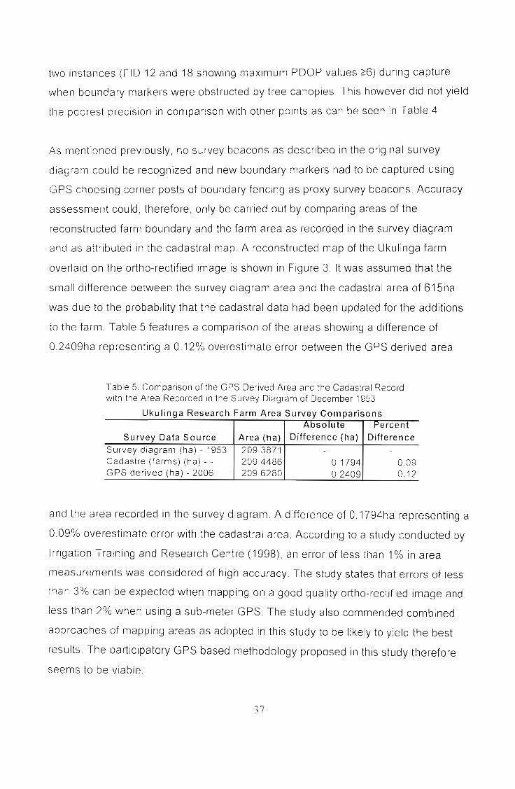
to the farm. Table 5 features a comparison of the areas showing a difference of
0.2409ha representing a 0.12% overestimate error between the GPS derived area
Table 5, Comparison of the GPS Derived Area and the Cadastral Recordwi h the Area Recorded in the Survey Diagram of December 1953
Ukulinga Research Farm Area Survey ComparisonsAbsolute Vercent
Survey Data Source Area (ha) Difference (ha) Difference
Survey diagram (ha) - 1953 209.3871 - -
Cadastre (farms) (ha) - - 209.4486 01794 0,09GPS derived (ha) - 2006 209,6280 0,2409 0,12
and the area recorded in the survey diagram. A difference of 0.1794ha representing a
0.09% overestimate error with the cadastral area. According to a study conducted by
Irrigation Training and Research Centre (1998), an error of less than 1% in area
measurements was considered of high accuracy The study states that errors of less
than 3% can be expected when mapping on a good quality ortho-rectified image and
less than 2% when using a sub-meter GPS, The study also commended combined
approaches of mapping areas as adopted in this study to be likely to yield the best
results. The participatory GPS based methodology proposed in this study therefore
seems to be viable.
37
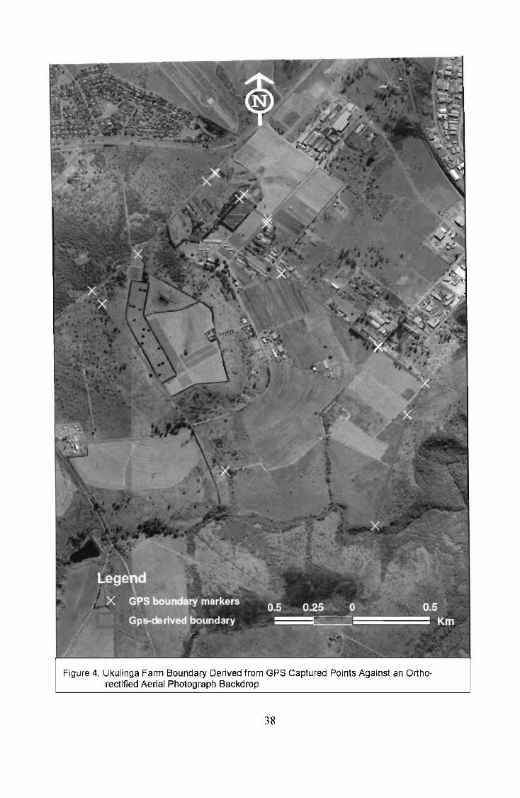
Figure 4. Ukulinga Fann Boundary Derived from GPS Captured Points Against an Orthorectified Aerial Photograph Backdrop
38

5. ANALYSIS AND MAPPING OF BASIC COMMUNAL LANDADMINISTRATION SYSTEMS
5.1. Introduction
The Makurung Village case study is undertaken to understand basic communal land
administration systems. It is the objective of this study to provide an analysis of basic
communal land administration systems for possible recommendation to CLaRA
implementation.
5.2. The Study Area
The area of study is Makurung Village, a communal area under the jurisdiction of
Bakgaga Traditional Authority. The village is centred at Latitude 24°21' and Longitude
29°32'. The area forms part of gaMphahlele (generally referring to the land area
within Bakgaga Traditional Authority's jurisdiction) in the Lepelle-Nkumpi Local
Municipality. Lepelle-Nkumpi Local Municipality is one of the five municipalities of the
Capricorn District Municipality. Capricorn District Municipality is one of the four district
municipalities making Limpopo Province. It is situated at the centre of the Limpopo
Province where the capital city, Polokwane, is located. Limpopo Province is found at
the northern part of South Africa, sharing national borders with Zimbabwe, Botswana
and Mozambique.
5.3. Mapping with Global Positioning Systems (GPS) and GeographicInformation Systems (GIS)
Members of Makurung Communal Land Administration Team composed of the
headman, a member of the headman's family (brother) and the headman's Secretary
were asked to define the boundaries of their land administration area. A hard copy of
a 1.50,000 topographic map was used to identify the boundaries of the communal
land administration area. Boundaries that could be identified on the map were marked
39

as the Communal Land Administration Team identified them on the topographic map
The boundary identification and marking exercise was followed by a tour by the
Researcher and members of the Communal Land Administration Team driving along
accessible parts of the boundary of the land administration area and taking other
paths where boundary markers are not accessible
A Trimble Geo-XTTM hand-held GPS unit was used to record coordinate points
marking the communal land administration boundaries. The GPS unit, operating with
TerraSync™ software, was set to World Geodetic System 1984 (WGS 84) and to the
Geographic Coordinate System (GCS) in latitude and longitude decimal degrees to
map Makurung Village.
The recorded GPS coordinate points of boundary markers were entered into GIS
overlaid on a Geo-referenced tagged image format to produce a Raw Data Map
A screen digitization application was conducted on the Raw Data Map connecting
boundary markers thus creating a boundary vector map The final map of Makurung
Communal Land Administration was then produced. A flowchart representing the GIS
operations conducted in mapping Makurung Basic Communal Land Administration
area, is presented below
40

\1,IL\IIIIII~
htllll1t!;II'\ 111'lI'
(,1''-' ('1<lldil1ak,
1\01 11 It! <I 1il" "I'\ LII,,, ..I'
------~--~
(,u,-lil"l1\ 'pU",I,ll'hi,
\1""----'-=----
L..-,....__~ \1,lhllrHII;! \ ilhl~'-
,lilt! Ill,' IK'idnmillt'\ ill a!Ct.',
,----Criteria:\holl 1)( ll1kl.li..:,01' «111l1111 11~ ,lilt!Oil (oPO l1lap
Ct'itrria: (\lIllll'(1
(l1()ldiI1at,;
hOlllld,ll) 1,,,iiHSIn pl'< IL!UCC llldr'
1'Icl i:ni Ilal)
bUlIlllhIIY!Join:s
al1d \11J1(1
k:llllr..:s
'-',:1,;,'\1 di~il ill' I"
I":PI\ld lIt.'C 1,'\ll1l1d:JrI
\,I;tkllrullg ("'llllllilll,i1
I :lIld ,\dlllilli'II',lli'1J1,\1''':;1 boull I,ll) 111<.11'
Figure 5 Flowchart GPS-based Mapping Operations of LandAdministration Systems In a GIS
41

5.4. Interviews
The Makurung Land Administration Team and the Bakgaga Traditional Authority were
Interviewed on land administration, respectively. They explained their land
administration structure, individual components making up the structure and the
responsibilities of each component The land administration teams also provided
detailed explanation on the functioning of the system, as a whole and not parts in a
whole. Data obtained from the interviews was then analysed and then a clarified
conventional system of communal land administration presented.
5.5. Analysis
Participatory GPS- and GIS-based mapping is a logical step by step process and
requires particular data sets to accomplish. The flowchart represented by Figure 5
provides the data sets requirements, GIS operations pertinent to and the subsequent
output of the process.
42
6. DATA ANALYSIS: MAPPING OF BASIC COMMUNAL LANDADMINISTRATION SYSTEMS
6.1. Introduction
This chapter focuses on the analysis of responses obtained from interviews with
Makurung Land Administration Team and Bakgaga Traditional Authority on the
operation of their Communal Land Administration Systems. The analysis would clarify
on the workings of the said systems. Attention is also directed at the Participatory
GPS mapping exercise undertaken with the Makurung Land Administration Team.
Questions posed to Makurung Land Administration Team were mainly on how land
allocation requests are processed, on transfer and registration of land rights, on the
structure and system of their land administration and on what they deem as
challenges facing the system. Bakgaga Traditional Authority responded to a different
set of questions relating to the broader operation of the land administration system.
Appendix 1 and Appendix 2 represent questions posed to Makurung Land
Administration Team and to Bakgaga Traditional Authority, respectively. Data
collected through participatory mapping is also presented and an analysis is given.
6.2. Interview Data: Makurung Land Administration Team
Induna Shogole and members of the Makurung Land Administration Team were
interviewed on their communal land administration practices. The following are their
responses to the questions asked
6.2.1. Land Allocation Procedures
According to Makurung Land Administration Team, an applicant approaches the
Induna in a particular ward for a residential/crop field site, either having identified a
site or prior to site identification. If an applicant is from another area outside the
43

jurisdiction of the Induna, it is incumbent upon the person applying for a site to be in
possession of a release letter from the previous Induna that serve as a testimonial.
Such letter should, among other issues, indicate that he or she co-operated and
worked soundly with them It is highly unlikely that a person with a bad record could
be accepted to become a member of the tribe or community.
As a matter of procedure, foreigners are illegible for site allocation. Only male
foreigners married to a local woman could be allocated a site. It should, however, be
noted that the allocated site would then be registered in the name of the local spouse.
On availability of a site, the Induna issues a letter to the applicant, sending the
applicant to the Tribal Secretary's office. The letter recommends to the Tribal
Secretary that the site in question be allocated to the applicant. At the Tribal
Secretary's office an application form is then completed, signed and stamped by the
Secretary and forwarded to the Department of Agriculture. An official of the
Department of Agriculture completes the relevant Section and then forward the form
to Department of Local Government and Housing for registration of a Permission To
Occupy (PTO). The applicant is then issued with a PTO, which serves as prove that
the site occupant is a legally recognized occupant.
6.2.2. Recording of Land Rights
Makurung Land Administration Team records land rights of its citizens. It is
acknowledged that such records are not kept up to date, particularly the sites
acquired through inheritance. The reason for the poor record keeping in that regard is
because the land administration team is not warned of such changes and there are
no available regulations that compel recipients of such properties to inform and
register those changes with the land administration system. The land administration
system gets to know of them when a dispute is lodged with their office.
44

6.2.3. Transfer of Land Rights
Community rules provide for a possible transfer of land rights from among members
of the community on both residential and crop-field sites. Members could exchange or
give land rights on a particular site or portion of land to any other member of
community, following the set procedures. The affected parties should have an
agreement on the proposed transfer that which could be temporary/seasonal or
permanent Parties to the agreement would then jointly present their agreement to the
land administration team for consideration.
If the Induna and the land administration team ratify the application for permanent
transfer of rights, then a similar procedure to the one on land allocation is followed.
The site will then be registered in the name of the new occupier
Transfer of rights could be effected as a result of land rights inheritance. As a natural
practice, the youngest son in the family inherits the site whereon the household is
built However, now of recent, families are flexible on inheritance allowing any child to
inherit The family could nominate any child, particularly the indigent child to be the
one to inherit family estate by concurrence
45

Ilnduna(Headman)
t i Induna's FamilyII~
Bathusi baNtona(Headman'sAssistants)
~
Bangwaledi(Secretariat)
~
Kgoro(Communitymembers)
Figure 6: A Graphic Representation of Makurung Land Administration SystemResponsible for Makurung Village, gaMphahlele, Limpopo
6.2.4. Challenges Facing Makurung Land Administration System
Makurung Land Administration System is plagued by three major problems Firstly,
there are illegal occupiers of land who did not follow the set application process to
acquire land. Several households illegally occupy land close to a graveyard. Illegal
occupiers were reported to Bakgaga Traditional Authority. A case is yet to be
resolved.
Secondly, Makurung Land Administration System is in dispute with Dithabaneng
community over ward boundary. According to Makurung Land Administration System
the Dithabaneng community claims almost half of their land area Both communities
46
are members of Bakgaga Ba Mphahlele Tribe falling under the administrative
jurisdiction of Bakgaga Traditional Authority Bakgaga Traditional Authority is asked to
mediate in the conflict and the matter is currently before the tribal court. It is hoped
that the case will soon be resolved. Among the contestations raised by the
Dithabaneng community is that they had contributed towards the purchase of the
farms currently under the jurisdiction of Makurung Land Administration System and
therefore have a rightful claim to the properties. The fact that Makurung Land
Administration System's land area is made of bought farms complicates the matter
and will require a welt-thought solution that will address future claims likely to arise
from other communities of the Bakgaga Ba Mphahlele Tribe who are currently not
residents of Makurung Village.
Thirdly, Makurung community and Dithabaneng community are at loggerheads over
control of the Agricultural project currently administered by the Makurung community_
According to Makurung community the agricultural project is located on land that they
formerly used as crop-fields_ Makurung Land Administration System allocated and
administered those crop-fields before the launch of the agricultural project. In the late
1980s a development project constituted by members of both communities
recommended to the Makurung Land Administration System that an agricultural
project be launched to optimally utilize the land. In the late 1990s the Dithabaneng
community felt that the project is on their land and should have a stake in its
administration. Reasons advanced by the Dithabaneng community are similar to
those raised under boundary dispute Solutions to the boundary dispute may help
resolve the dispute over administration of the agricultural project.
47

6.3. Bakgaga Traditional Authority
6.3.1. Introduction
The Bakgaga Traditional Authority exercises authority over fourteen (14) basic land
administration systems of which Makurung form part. Below is their response to the
questions seeking to understand how their land administration system operates:
• Applicant approaches Induna in the area
• Induna, on availability of a site and the applicant satisfying the set
allocation criteria, issues a letter to the applicant.
• Applicant takes a letter to the Tribal Secretary's office.
• Tribal Secretary completes a form, signs it and put a stamp of approval.
• Application is forwarded to the Municipality for the issuance of a PTO.
• Municipality issue PTO in favour of the applicant.
• Municipality request local Department of Agriculture to demarcate a crop
field.
6.3.2. The Hierarchical Structure of Bakgaga Traditional Authority'sLand Administration System
(a) The Chief or Chieftainess
The Chief or Chieftainess is the head of a particular tribe and also that of an
established tribal authority ruling over a number of villages within whose area of
Jurisdiction a number of Indunas exercises their authority. Chieftainess NS Phatudi
Mphahlele with several Indunas serving under her leads the Bakgaga Traditional
Authority Her role as a traditional leader is to perform functions provided for in terms
of customary law and customs of the traditional community and as per applicable
legislation (eg as per provisions of Section 20(1 )(a)-(n) of Traditional Leadership and
Governance Framework Act, 2003 (Act 41 of 2003))
48

(b) Senior Mokgomana
The Senior Mokgomana is the second-in-command, the Chief or Chieftainess'
assistant and confidante. His or her duties are, amongst others, the collation of
reports from various structures that make-up the tribal authority such as Bakgomana,
tribal court and tribal council and to update the Chief or Chieftainess on all matters.
All administrative matters relating to land and governance of Indunas are reported to
him or her to be taken to the Chief or Chieftainess. According to protocol the Indunas
communicate with the Chief or Chieftainess through the Senior Mokgomana. Senior
Mokgomana regularly meets the Tribal Secretary to discuss matters of concern to the
tribe.
(c) Tribal Secretary
The Tribal Secretary is a public servant, serving the tribe at the tribal office. He or she
serves as an administrator responsible for, amongst other duties, the safekeeping of
legal contracts with third parties doing business within the area of jurisdiction of
Bakgaga Traditional Authority, act as a Commissioner of Oath, administer tribal funds
and reconcile cashbooks. He or she reports directly to the Chief or Chieftainess on
matters relating to his or her functions.
(d) Bakgomana
Bakgomana are appointed by the Chief or Chieftainess to assist in the administration
of the traditional authority. They are mostly ordinary members of the society who are
enlightened or may be members of the royal house who are deemed to possess
capacity to contribute positively to the administration. Their duties are amongst
others, to look after the welfare of the royal kraal, to preside over civil cases brought
before the tribal court and to advise and provide support to the Chief or Chieftainess.
49

(e) Tribal Council
The tribal council is constituted by community elected councillors, Senior Mokgomana
and all lndunas in the area of jurisdiction of the tribal authority The roles of the tribal
council are, amongst others, to administer affairs of traditional communities in
accordance with customs and traditions, to assist, support and guide traditional
leaders in their performance of functions, to support municipalities in identifying
community needs, and to perform all duties as prescribed by Section 4(1) of the
Traditional Leadership and Governance Framework Act, 2003 (Act 41 of 2003).
(f) Tribal Treasurer
The tribal Treasurer reports to the Tribal Secretary. He or she is a public servant
responsible for handling finances of the tribal authority. He or she also assists the
Tribal Secretary in performance of some of the administrative duties.
(9) Tribal Court
The tribal court adjudicates over land-related and social matters. Bakgomana are
actively involved in the administration of court activities. Senior Mokgomana or the
Chieftainess or Chief in exceptional cases, act as the judge of the tribal court. The
court does not have jurisdiction over criminal matters Criminal cases are reported to
the South African Police Services and are dealt with in the magistrate court.
(h) Induna
An Induna is a traditional leader exercising authority within the area of jurisdiction of a
Chief or Chieftainess in accordance with customary law. lnduna reports to the Senior
Mokgomana on all matters relating to land administration and governance By virtue
of their pOSitions, Indunas are automatic members of the tribal council.
50

(i) Induna's family
The Induna's family provide support to the Induna and look after the interest and
welfare of the family in accordance with customary law. The family is responsible for
selecting the hire to the throne.
0) lnduna's Assistants (Bathusi ba Ntona)
Induna has the right to select his or her assistants in accordance with customary law.
The appointed assistants help the Induna in his/her daily administration. She or he
consults with them before making any decisions whereas reserving the right to make
a final decision. Guests and applicants for sites will go through the assistant as a
matter of protocol and not approach the Induna directly Alternatively the Induna may
not discuss any request with a guest in the absence of an assistant.
(k) Secretariat (Bangwaledi)
The community appoints the Secretariat to serve them in the office of the Induna. The
Secretariat is responsible for issuing letters to applicants of sites, which are then
taken to the Tribal Secretary for processing. The Secretariat also records resolutions
of the kgoro (community meetings) or judgements of the local court.
(I) Kgoro (Community members)
Community members older than eighteen years may sit at the community gathering to
discuss matters of interest to the community or to make inputs towards the resolution
of a dispute brought before the Kgoro It is at the Kgoro where community members
receive updates of the latest developments relating to their community or tribe at
large The Bakgaga Traditional Authority has given special orders that every Induna
51

should call the Kgoro sitting at least once a month to communicate with, or update,
the community of the latest developments
Kgoshi/gadi(Chief/tainess)
TribalSecretary
TribalTreasurer
Senior~ Mokgomana
IBakgomana
Ilnduna
Ilnduna's family
Bathusi ba Ntona(Induna's Assistant)
Bangwaledi(Secreta riat
Kgoro(Communitymembers)
I
I Tribal Court I TribalCouncil
Figure 7 Hierarchical Structural Representation of Bakgaga Traditional Authority
52

6.4. ANALYSIS OF INTERVIEW RESPONSES
Table 6 A Comparative Analysis of Land Administration Procedures According
to Bakgaga Traditional Authority and Makurung Land Administration
System.
Bakgaga Traditional Authority
f Applicant approaches Local Induna for
a site.
Makurung Land Administration
System
• Applicant approaches Induna for
residential site or crop field either
having identified a site or prior to
site identification.
Induna, on availability of a site and the
applicant satisfying the set allocation
criteria, issues a letter to the applicant
recommending site allocation.
Applicant takes the letter to the Tribal
Secretary's Office.
r
Tribal Secretary completes a form, sign
it and put approval stamp
Applicant forwards the stamped form to
the local municipality requesting that a
PTO be issued in favour of the
applicant
•
53
If applicant is from another area
outside the jurisdiction of the
Induna, the person should have a
release letter from the previous I
Induna indicating that he or she co
operated and worked soundly with
them.
Upon availability of site, a letter is
issued to the applicant, sending the
applicant to the Tribal Secretary'
office.
Applicant takes the letter to the
Tribal Secretary's Office.
Application form is then completedand is signed and stamped by theSecretar .Applicant forwards the completed
form to the Department of
Agriculture.

~MuniciPality issues a PTO in favour of
the applicant.
-S-akg-a-g-a-T-ra-d-j-ti-o-n-a-'--I---:CA-u-t-:-h-o-r':-1ty------r-:-:M:-a--:-k-u-r-u-n-g----;-L-a-n---;-d--A~d-m-:-j-n-:-js-:t-ra----:t:-:-j0-1--:1,
System
Department of Agriculture completes
the relevant Section and then forwards
the form to Department of Local
Government and Housing.
Department of Local Government and
Housing Issue a Permission To
Occupy (PTO) In favour of the
applicant.
6.4.1. Land Allocation Procedures
Procedures for the allocation of communal land as elucidated by the Makurung Land
Administration Team and Bakgaga Traditional Authority illustrate some areas of
commonality and congruence. There is consensus on the first stage of the application
process which is a "knock at the door' at Induna's place. The Induna, together with
administrators, is better placed to know of available land for allocation as requested
by the applicant. The applications will at that level be put under scrutiny, to verify
compliance with the set land allocation criteria and community rules.
The Induna sends his or her assistant to show the qualifying applicant a site due for
allocation. If the applicant finds the site suitable, a letter is issued in favour of the
allocation, to be submitted to the Tribal Secretary to proceed with the processing of
the application. It is the responsibility of the applicant to take the letter to the Tribal
Secretary's office and subsequent correspondences to all the other authorities until
the final stage is reached.
The two administration authorities concur on the step that follow where the Tribal
Secretary completes a form, append signature and put approval stamp to it. Again the
S4

applicant ensures that the approved form reaches the next level within the
administration hierarchy However, there is lack of clarity as to which authority
becomes responsible to further process the application According to the Makurung
Land Administration Team the application is then forwarded to the Department of
Agriculture, whereas, Bakgaga Traditional Authority asserts that the local municipality
is the responsible authority to oversee the application Both authorities agree on the
purpose of the submission that being to obtain a Permission To Occupy (PTO). It
should, however, be noted that PTOs currently issued outside KwaZulu-Natal are
legally invalid owing to the withdrawal by the Minister of Land Affairs of the initial
authority given for that purpose to the MEC for Local Government and Traditional
Affairs. Any PTOs, which have been issued by the various persons, institutions and
structures since the 2ih April 1994 are not legally valid with the exception of the
KwaZulu-Natal province (Sibanda, 2006)
The withdrawal by the Minister of Land Affairs of the authority to issue PTOs has
created an administrative vacuum and a breakdown in administration of communal
land Due to lack of communication between government and traditional authorities
PTOs are continuously being issued, albeit illegally Government is challenged to
close the administrative vacuum created by the withdrawal, lest communal land
administration remain chaotic.
The confusion in the process beyond the Tribal Secretary could be ascribed to the
fact that, at local level, the Makurung Land Administration System issue a letter of
recommendation to the applicant for submission to the Tribal Secretary and are
therefore ignorant of subsequent processes. The Bakgaga Traditional Authority, by
virtue of being a referring institution, knows exactly which institution is responsible for
considering the application In the spirit of improved service delivery and Batho Pele,
People First policy, it is imperative that institutions providing services should be
informed and be adequately capacitated to better serve their clients. Bakgaga
Traditional Authority should communicate the process followed in site allocation to
basic Communal Land Administration Systems within their area of jurisdiction.
ss

6.4.2. Comparative Analysis of the Role Played by Communal LandAdministration System and that to be Played by the EnvisagedLand Administration Committee
Five subtopics are discussed below to unpack how the current situation in communal
areas is likely to influence the implementation of CLaRA. It is the objective of this
study to provide a generic framework towards implementing the Act. Focus is directed
to the analysis of the structural composition of the Communal Land Administration
System, inherent decision-making processes, the processes leading to the
development of community rules, how land rights are been recorded and the role
played by gender in land allocation
6.4.3. Analysis of the Structural Composition of Communal LandAdministration System against Land Administration CommitteeEnvisaged by CLaRA.
Bakgaga Traditional Authority is made up of fourteen (14) basic communal land
administration areas led by an equal number of Indunas. All but one of the Indunas is
female. Five administrators constitute Makurung Village's Land Administration
System. Only one of the five administrators is female. The dominance of land
administration by male members could be attributed to the fact that African societies
are patriarchal in nature where female members were not considered for leadership
roles and had to take a back seat and trust their male counterparts to provide
leadership. Bakgaga Traditional Authority is led by a female, Chieftainess NS Phatudi
Mphahlele She is expected to raise a son who will upon maturity assume the throne.
The Communal Land Rights Act, 2004 (Act NO.11 of 2004) advocates a
representative Land Administration Committee. In terms of Section 22(3) of the Act at
least one third of the total membership of a Land Administration Committee must be
female. One member of the Land Administration Committee should represent the
Interests of vulnerable community members, including women, children and youth,
the elderly and the disabled (Section 22(4) of Act No. 11 of 2004)
56

The scenario painted by the above deliberations calls for an overhaul of the current
system of communal land administration to align with the prescripts of the Act. The
Makurung Communal Land Administration System's female representation IS
currently at one fifth. The challenge is to find willing women to take up positions In
land administration and for men to accept the changes and support women in their
new roles.
6.4.4. Decision Making Processes
The current system of communal land administration provides for, although to a
limited extent, democratic decision making. The Chief or Chieftainess consults with
the tribe on matters that affects the tribe or assets belonging to the tribe. A tribal
gathering (Kgoro) is called to discuss matters of common interest. Community
structures such as the tribal council (a structure constituted by community-elected
councillors and lndunas) play a role in enhancing democratic decision making. Its role
is to administer affairs of traditional community in accordance with customs and
traditions, to assist, support and guide traditional leaders in their performance of
functions and to perform all other duties as prescribed by Section 4(1) of the
Traditional Leadership and Governance Framework Act, 2003 (Act No.41 of 2003).
The tribal council and the Kgoro are two important forums that present an opportunity
for community members to influence decisions on matters of common concern. It
should, however, be noted that the interests represented will be largely determined by
the composition of the structure
According to Bakgaga Traditional Authority instructions are issued to all Indunas to
hold Kgoro at least once in a month. The monthly meetings are meant to
communicate matters relating to the tribe obtained from the Bakgaga Traditional
Authority and to also provide a platform for tribe's people to input on governance and
register their concerns on matters of interest.
S7

In terms of the provisions of the Communal Land Rights Act, 2004 (CLaRA) the
community must make and adopt its community rules and have them registered
(Section 19( 1)) CLaRA advocates governance by the people. Community rules must
regulate the administration and use of communal land by the community as
landowner within the framework of law governing spatial planning and local
government (Section 19(2) (a) of Act No. 11 of 2004). Public participation in the
making and adoption of community rules ensures democratic governance. The
elected leaders will be compelled to govern in the spirit of and guided by the
community rules. The leaders become community servants with the responsibility to
constantly consult with their masters, the community
6.4.5. Community Rules Development Process
The Makurung community has established community rules. These community rules
are, however, not documented. They are verbally passed on from one generation to
the next with necessary amendments effected over time. Community rules are visited
whenever the Ileed arises or when there are new challenges to come to grips with.
Section 19 of the Communal Land Rights Act provides for public participation in the
making and adoption and registration of community rules. The adopted community
rules are binding on the community and are deemed a matter of public knowledge on
registration Systems are put in place to ensure that the community rules are not in
conflict with the Constitution and CLaRA (Section 19(4)) Community rules may be
amended or revoked by a community in a general meeting and in a manner
applicable to their adoption (Section 20(1 )). Democratic participation is advocated in
the drafting, adoption, registration and amendment and revoking of community rules.
S8

6.4.6. Recording of Land Rights
Data collected from Makurung Communal Land Administration System indicates that
land rights are recorded and such a record is properly kept, although to a limited
extent All persons legally occupying site at Makurung have their land rights recorded
and are in possession of a Permission To Occupy (PTO) certificate. It has been noted
that inherited land rights are not properly recorded There is currently no community
rule in existence that compels people inheriting land rights to record such transactions
to Makurung Land Administration System for entry in the land register. Makurung
Land Administration Committee should consider closing the rules gap as a matter of
urgency. At present the land administration system gets to know of inherited land
rights when a dispute is registered over those sites.
The CLaRA implementation is expected to ameliorate the situation. Section 24(3) (a)
(i), (ii) provides guidelines with regards to allocation of new order rights on communal
land. Section 24(3) states, "In the exercise of its powers and the performance of its
duties a Land Administration Committee administration must-
(a) take measures towards ensuring-
(i) the allocation by that committee, after a determination by the
Minister in terms of Section 18, of new order rights to persons)
including women, the disabled and the youth, in accordance with the
law;
(if) the registration of community land and of new order rights;
(b) establish and maintain registers and records of all new order rights and
transactions affecting such rights as may be prescribed or as may be required
by the rules"
Section 24(3) (b) compels the Land Administration Committee to establish and
maintain registers and records of all new order rights and transactions of such land as
prescribed or required by rules. CLaRA advocates the registration of land rights and
59
land transaction relating thereto. Such records will enhance land rights holders tenure
and serve as a useful resource in adjudication of land related disputes.
6.4.7. Role Played by Gender in Land Allocation
Makurung Land Administration System does not consider gender as a criterion in
their land allocations. All applicants are treated equally, irrespective of their gender
affiliation. Criteria for land allocations relates to communal membership, age of the
applicant and allegiance to the land administration system, amongst others. In other
communities, KwaZulu-Natal being the most popular province in terms of prevalence,
female members of the community were, until recently, not legible for site allocations.
Mothers could have sites allocated and registered in the names of either their sons or
of their male relatives. That arrangement promoted abusive relations.
CLaRA emphasizes gender equality in the allocation of new order rights. Section
24(3)(a)(i) dictates that new order rights be allocated by the Land Administration
Committee to persons, including women, the disabled and the youth in accordance
with the law. Gender discrimination ill land allocation will be a criminal offence and
transgressors will be liable for prosecution in terms of Section 41 of CLaRA.
60

6.5. GPS RECORDINGS OF BOUNDARY DATA
6.5.1. Mapping Makurung with Global Positioning System (GPS)
After Identification of the communal land administration boundaries on the
topographic map by the Land Administration Team, GPS recordings of coordinate
points marking communal land area were taken. A Geo-XTTM hand-held GPS unit
was used to record points of the communal land boundary as identified by community
members (Participatory mapping). Table 7 shows the data collection process followed
in Participatory GPS mapping.
61
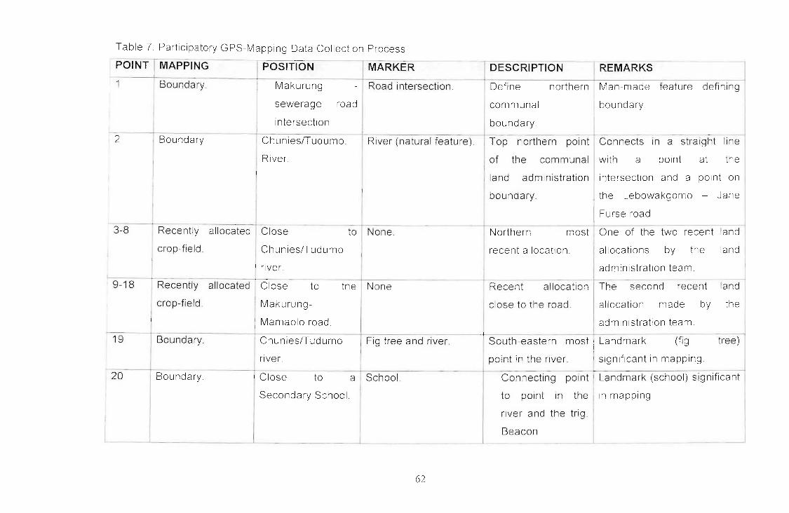
Table 7 Participatory GPS-Mapplng Data Collection Process
POINT MAPPING - - I REMARKS-- -
POSITION MARKER DESCRIPTION
1 Boundary Makurung - Road intersection Define northern Man-made feature defining
sewerage road communal boundary
intersection boundaryI
2 Boundaryf--.
ChunieslTudumo River (natural feature) Top northern point Connects In a straight line
River of the communal with a pOint at the
I land administration intersection and a point on
boundary. the Lebowakgomo - Jane
Furse road
3-8 Recently allocated Close to None Northern most One of the two recent land
crop-field. ChunieslTudumo recent allocation. allocations by the landI
river. administration team
9-18 Recently allocated Close to the None Recent allocation The second recent land
crop-field Makurung- close to the road. allocation made by the
Mamaolo road administration team.
19 Boundary ChunieslTudumo Fig tree and river. South-eastern most I Landmark (fig tree)
river. point in the river. significant in mapping
20 Boundary Close to a School Connecting point Landmark (school) significant
Secondary School to pOint In the in mapping
river and the trig
Beacon- - - ---
62

MARKER I DESCRIPTIONPOI~ MAPPING hOSITION
! None Boundary Hill top I Trigonometric beacon I Connecting point
REMARKS
Use of trig Beacon in
defining boundaries display
I basic level mapping Point
Southern boundary, 21 I Boundary
None r Boundary.
not taken - beacon Identified
on topographic map
Old-church building ISouthern most pOint Significance of landmarks In
-k _Iand primary school of the communal mapping (old church building
boundary and school)
Hill top. Trrg Beacons number Southern boundary I Beacons defining boundary
100 and number 8 of communal land ; offers level of accuracy In
mapping. Points were
necessary to captureno 1
boundary.
western point of the I identifying and
communal land communal land
mapping
22 I Boundary Edge of Road and beacons
Lebowakgomo -IJane Furse road,
I straight line with
! beacons.
63
Define south- I Landmarks assisting in

rESCRIPTION IREMARKS ~
Connecting pOint Main road defining western'
I boundary of communal land.
I
POSITION , MARKER
Intersection of I Roads.
Lebowakgomo-
I Jane Furse and
I Hwelereng
Makurung roads
Sewerage plant I Road. -- IConnecti~ point !Significance of features in I
Idefining northern mapping
boundary II Edge - of Road. - -- -- Defining northlS"hows the role played by
I Lebowakgomo - Iwestern boundary I features in mapping and their
Jane Furse road, Iconnecting in a optimum use by local people
straight line with straight line to a
I road leading to the point taken at the
~ sewerage plant _ __ _ I sewerage plant _ ~ _
tBoundary- -
I24
~NT]MAPPING _
23 Boundary
---1-=--None I Boundary.
I
6.+

6.6. ANALYSIS OF GPS RECORDINGS OF BOUNDARY DATA
6.6.1. Identification of Boundaries of Basic Communal LandAdministration Area
The ability of communities to define and map their communal land administration
areas is central to the successful implementation of the Communal Land Rights
Act. 2004 (Act No. 11 of 2004). Knowledge of communal boundaries is crucial
during the land rights enquiry process conducted by an appointed Land Rights
Enquirer. Persons or communities who claim land rights on a property are
expected to indicate the extent of their claim. The process would unravel land
rights attached to a particular property by identifying land rights holders and
would also provide an opportunity to document the boundaries of a basic
Communal Land Administration System.
The Makurung Communal Land Administration Team was able to identify
boundaries that represent their communal land. Natural features such as hills
and a river that made up the boundary were used in the identification process.
Landmarks such as trigonometric beacons, buildings and roads were identified
as making up the boundaries of Makurung Village. Community's ability to use
landmarks such as trigonometric beacons in mapping, despite low literacy levels
among the adult population in the area, illustrates availability of basic mapping
skills. Such skills are vital in support of the implementation of the Communal
Land Rights Act, 2004 (Act No. 11 of 2004).
The Makurung Communal Land Administration Team also participated in the
boundary recording of the recently allocated crop fields. The exercise was
conducted to demonstrate the significance of continuous recordings and update
of the communal resources.
65
6.6.2. Accuracy of GPS Recordings
In this study, attention was paid to the Horizontal Dilution of Precision (HOOP) as
a 2 - dimensional accuracy indicator. The decision to consider the horizontal
component (x, y) only, as opposed to the 3-dimensional accuracy indicator (x, y,
and z) was informed by the fact that elevation of data was not of significance.
A Trimble Geo-XTTM hand-held GPS was used to record coordinate points
marking the administration area. Differential correction procedure on the GPS
recorded data collected on the 12 November 2005 failed. Upon enquiry from
Trignet Mowbray the author was informed that the Trignet system for the area
crushed during November and December 2005. Consequently all differential
correction data for that period is lost. The nearby Trignet Base Station to the
study area is Trignet Pietersburg located at latitude 23.55°, longitude 29.27° and
ellipsoidal height 1307.67 metres above sea level. Attempts were made to
acquire information from Trignet Thohoyandou, a base station closer to Trignet
Pietersburg located at latitude 23.04°, longitude 30.23° and ellipsoidal height
630.29 metres above sea level. Trignet Thohoyandou experienced the same
problem as Trignet Pietersburg.
According to vendor specifications and as confirmed by Serr, Windholz and
Weber (2005) the device is capable of obtaining 3 - 5m accuracy without post
processing correction. The unavailability of differential correction data is not of
grave concern since the base map (as the only available spatial reference) was a
1:50,000 topographic map whose accuracy, according to Gyamfi-Aidoo,
Schwabe and Govender (2005), cannot exceed 5m.
6.6.3. Data Processing in GIS
The collected data in the form of GPS-recorded coordinates of points marking the
boundary of the communal land administration were overlaid on a topographic
66

map. The GIS operation produced a topographic map in a Geo-referenced
tagged image format depicting overlaid recordings of point coordinates marking
communal land boundaries illustrated by Figure 8 (Raw Data Map).
~-- .
Makurung Raw Data Map
EGE.ND• Point Calli
.,....... '0
"
- '.
. \
Figure 8: Makurung Raw Data Map
Through on-screen digitizing, the coordinates marking communal land
boundaries were connected and a Makurung land administration boundary map
was produced, represented in Figure 9. A flowchart on GPS-based mapping
operations of land administration systems in a GIS, Figure 5, outlines the process
followed. Below is the final product, map of Makurung village:
67
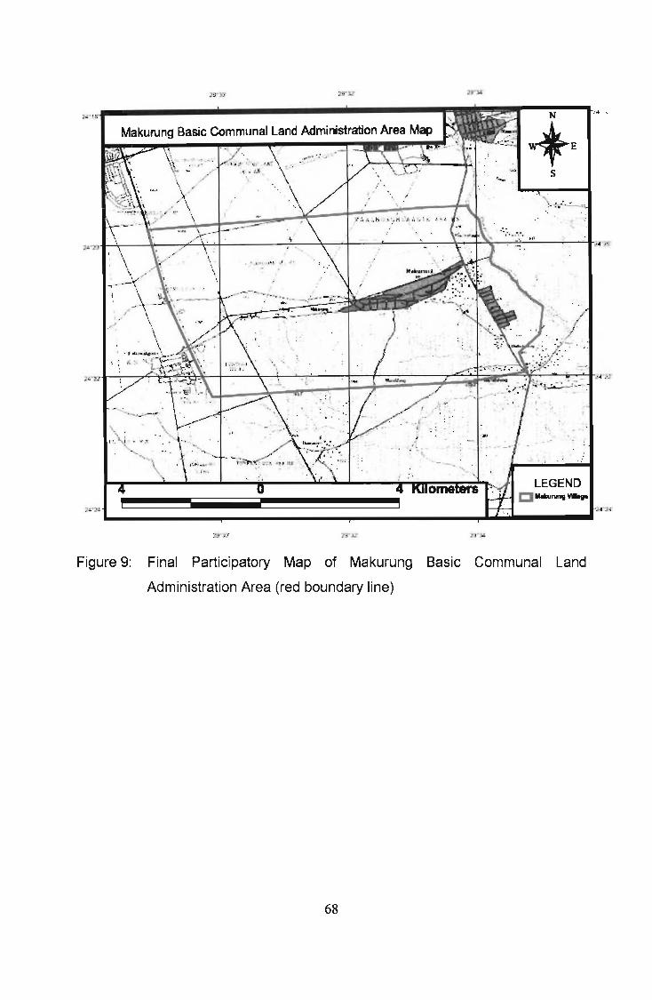
;,_ ..,".
s
!!!II..~-·N~--.."····'wtE
.....
2i2 •
Makurung Basic Communal Land Administration Area Map
,- '
";-4.].:L.- -.. ,.... ......~...__...
l ·1!f...---------------------------lIIIIIIIr"II
2!l'YJ
Figure 9: Final Participatory Map of Makurung Basic Communal Land
Administration Area (red boundary line)
68

7. CONCLUSION
7.1. Introduction
This study has two objectives. The first objective is to develop a participatory
GPS-based methodology for identifying and mapping communal land
administr'ation boundaries. The second is to analyze Basic Communal Land
Administration Systems. The success or failure of the study may be measured by
Its (in) ability to meet the objectives.
7.2. Defining Boundaries and Developing Participatory GPS-BasedMethodology for Identifying and Mapping Communal LandAdministration Boundaries.
Makurung Land Administration Team and Ukulinga farm manager defined their
communal land and farm boundaries, respectively. Their knowledge of the
boundanes coupled with the ability to define extent thereof was quite impressive.
Like the Asmat families in the study by Hile (2004) the Makurung Land
Administration Team placed a high level of significance on mapping their
boundanes. There is a contest over boundaries with the neighbouring village.
The community is convinced that by mapping their boundaries they will be able to
defend their territory against external threats.
Landmarks and natural features serve a significant role in defining boundaries.
The boundary Identification process was handled with ease, with the guidance of
landmarks and natural features.
Public participation was enhanced through active participation of the Makurung
Land Administration Team in defining and identifying their communal land
administration boundaries. Community members' ability to identify points along
the communal boundary proved vital in guiding the Researcher to record points
uSing the GPS tool. Providing the community members with training on how to
69

use hand held GPS unit, on the use of computers in downloading the collected
field data, IIlterpretation and manipulation, community members would after
considerable practice sessions, independently map their lands without requiring
assistance of outsiders.
7.3. Understanding of Existing Land Administration Structures andSystems
Basic communal land administration structures that exist in communal areas
appear in a hierarchical order as captured in Figure 6. The Induna is the head of
the system and is supported in his or her administration by family, advisors,
administrators (Secretariat) and the community. He or she reports to the Chief or
Chieftainess through the Senior Mokgomana. The structure of land
administration operates systematically in unison and is therefore referred to as a
land administration system as discussed under the Structure of Tribal Land
Administration.
The manner in which the system operates allows for consultations and public
participation in decision-making. Land rights holders' consent is sought on
matters that are likely to affect their land rights. Protocol is observed III all
dealings within the system and forms part of culture, captured in community
rules.
Community rules are not documented. Rules are verbally communicated in
community meetings and are passed on, from one generation to the next. It is at
community meetings where community rules are refined, amended and revoked
gUided by a common conviction that there is a need to do so. Implementation of
CLaRA would assist in ensuring that community rules are documented, thereby
preventing information gap between generations
Records of registered land rights are reasonably well kept, save for the recording
of IIlherited land rights, which require improvements. Rules for regulating
70

Inherited rights are yet to be developed. It is believed that once such rules are
developed land rights will be satisfactorily recorded.
There IS a need to enhance communication between administrative institutions
Makurung Land Administration Team and Bakgaga Traditional Authority gave
different versions on the responsible institution for processing the application for
a site beyond the Tribal Secretary. This is a cause for concern. The
administrators are expected to be conversant with the process so as to advice
clients accordingly. Lack of information on the part of administrators of the
process to be followed would sow confusion in applicants as they walk door to
door to have their request processed.
7.4. Achievements of the Study
The Makurung Village case study provided an analysis of the existing land
administration systems on communal land. Analysis on the status quo In
comparison to the envisaged Land Administration Committees by CLaRA
presented a broader view of the challenges ahead.
The land administration structures as exposed by the study could not be
adopted, in current form, into the CLaRA Land Administration Committees
because their make up is not in line with what CLaRA advocates.
The Ukulinga University Research Farm case study provided a better
understanding of the principles and operation of high precision handheld GPS
and also established the accuracy levels obtainable in surveys. A Participatory
GPS-based methodology for identifying and mapping communal land
administration boundaries was developed The efficacy of GPS is demonstrated
in the results obtained from a comparative study of coordinates of the
trigonometric beacon provided by the Surveyor General with those captured by
the Trimble Geo-XTTM GPS receiver.
71

Communities, particularly those in land administration, know their communal land
boundaries. They have mind maps of the areas and are able to identify
boundaries with ease. Natural features and landmarks, where applicable, are
reliable markers in identifying and mapping communal boundaries.
A Trimble Geo-XTTM GPS receiver was used to record boundary marker points
The mapping exercise carried out on Ukulinga farm achieved sub-metre post
processing differential correction accuracy as declared by the manufacturer. The
mapping process followed in the two case studies was also proved to be effective
and efficient. Moreover, it is believed that sub-metre accuracy levels would have
been achieved for the Makurung case study had post-processing differential
correction data been available
Research questions were answered satisfactorily. Clarity provided by the
collected primary data on the existing land administration systems and how
boundaries of those administration systems are defined proved insightful In fact,
communities have the knowledge and skills that enable them to identify their
land area. The research objectives were also achieved. As indicated earlier an
analysis of basic Communal Land Administration Systems was provided and a
participatory GPS-based methodology for identifying and mapping boundaries is
documented under the research methodology.
72

8. RECOMMENDATIONS
Based on the findings of this study and the foregoing conclusion it is
recommended that the methodology used in this study be considered in the land
rights enquiry process in the implementation of the Communal Land Rights Act,
2004 (Act No.11 of 2004) It is also recommended that community members be
offered capacity building and empowerment training in using Participatory GPS
and GIS. Such training opportunities, if provided, would improve the local
people's ability to map their land resources. It is further recommended that other
studies be commissioned to look at Communal Land Administration Systems in
other regions to establish local variations that may be considered in the possible
Implementation of the method.
7J

REFERENCES
Abeto, R., Calilung, Z., Talubo, JP and Cumatang, B. (2004) [Online]
Community Mapping in the Philippines: A Case Study on the Ancestral Domain
Claim of the Higa-onons in Impasug-ong, Bukidnon. Paper presented at the
Regional Community Mapping Network Workshop November 8-10, 2004,
Dillman, Quezon City, Philippines
Available: http//www.iapad .org/publications/ppgis/community_mappingjn_the_p
hillipines.pdf
Accessed July 2005
Alcock Rand Hornby D. (2004) Traditional Land Matters: A look into land
administration in tribal areas in KwaZulu-Natal, Legal Entity Assessment Project,
Durban, South Africa
Alspach, A.J. (1999) [Online] Integration of Geographic Information Systems
(G/S) in Regional Participatory Development Projects
Available: http//www.socsci.umn.edu/-bongman/gisoc99/new/alspach.htm .
Accessed July 2005
Anderson, PS (2000) [Online] Mapping Land Rights in Mozambique
Available: http://lt.ilstu.edu/psanders/geo/MOZAMART1/htm
Accessed July 2005
Augustinus, C (2003) Comparative analysis of land administration systems:
African review, Draft 1.
Baral, H., Petheram, R.J. and Liffmann, P. (2004) [Online] Agricultural Research
and Extension Network. Newsletter No. 50.
Ava ilable' http//www.iapad.org./publications/ppgis/agren_newsletter_50. pdf.
Accessed: July 2005
74

BUJang, M (2004) [On line] A Community Initiative Mapping Dayak's Customary
Lands in Sarawak, Diliman, Quezon City, Philippines.
Available. http/lwww.iapadorg/publications/ppgis/brimas_Malaysia. pdf
Accessed November 2005
Buschermohle, I'v1.J. (2005) [Online] Connecting your GPS receiver to ArcPad.
Biosystems Engineering and Environmental Science, University of Tennessee
Institute of Agriculture.
Available.http/lbioengr.ag.utk.edu/personnel/buschermohleMichael/docslBESS_
103pdf Accessed December 2005.
Charrois, D (1999) [Online] Study of the accuracy of averaged non-differential
GPS measurements.
Available. http/lwwwsyzcom/gps/gpsaveraging.html.
Accessed December 2005.
Chivers, M. (2003) [Online] Differential GPS Explained, ArcUser Online
Available http/lwwwesricom/news/arcuser/01 03/differential1 of2. htm!.
Accessed December 2005
Claasens, A (2001) It is not easy to challenge a chief- Lessons from Rakgwadi,
School of Government. University of the Western Cape, Cape Town
Communal Land Rights Act, 2004 (Act 11 of 2004), Cape Town, Republic of
South Africa
Corbley K. (2005) Field of beams: Communities are using a new generation of
portable GPS units to expand their G/S mapping, Winchester, USA, PRIMEDIA
Business Magazines and Media, Inc.
75

Corvallis Microtechnology Inc, (2000) [Online] Introduction to the Global
Positioning System for GIS and Traverse
Available. http//www.cmtinc.com/gpsbook/index.htm
Accessed November 2006
Cousins, B. (1999) At the crossroads. Land and agrarian reform in South Africa
into the 21 st century, Paper from a conference held at Alpha Training Centre,
Broederstroom, Pretoria, 26-28 July 1999
Cousins, B, (2002) Reforming Communal Land Tenure in South Africa - Why
land titting is not the answer: Critical comments on the Communal Land Rights
Act. Cape Town, South Africa
Crosnier, Y (2000) [Online] Spot Helps Resolve Land Tenure Issues, Sezanne,
France
Available http//ceoscnes.fr.81 OOlcd rom-OOb/ceos 1/casestud/mali/mali. htm
Accessed August 2005
Dale, P and McLaughlin J. (1999) Land Administration, Oxford University Press
Inc, New York, US
Dana, PH (1999) Global Positioning Systems (GPS) and Geographic
Information System (GIS) a "hands-on" approach, Department of Geography,
University of Texas, Austin
DePriest, O. (2006) [Online] Differential GPS
Available. http//www.gpsinformation.org/dale/dgpshtm Accessed. July 2006
GPS Primer (2003) [Online] A student guide to the Global Positioning System,
The Aerospace Corporation, USA
Available (http//www.aero,org) Accessed July 2006
76

Gyamfi-Aidoo, J. Schwabe, C and Govender, S (2005) Determination of the
fundamental geospatial data for Africa through a user needs analysis. A
synthesis report for the Chief Directorate: Surveying and Mapping, South Africa
Harris, T and Weiner, D. (2004) [Online] Community-Integrated G/S for Land
Reform in Mpumalanga Province, South Africa
Available: http//www.ncgia.ucsb.edu/varenius/ppgis/papers/harris.html
Accessed: April 2005
livula-Ithana, P (2004). Chapter 3 Land Tenure in Southern Africa; From
Colonialism to Modern Tenure Systems. In: Roth, M, Nxasana, V, Sibanda, S.
and Yates T (eds) National Land Tenure Conference - Finding Solutions,
Securing Rights Papers and perspectives from the National Land Tenure
Conference, ICC, Durban, South Africa, Department of Land Affairs, Lexis l\Jexis
Butterworths, Pretoria, South Africa.
Irrigation Training and Research Centre. (1998) Evaluation of techniques to
determine landscape areas. BioResource and Agricultural Engineering
Department, California Polytechnic State University, San Luis Obispo, CA 93407.
Keym, P (2001) An Application of a Choice Heuristic Algorithm for Mapping Land
Resource Allocation Problems Involving Multiple Parties and Conflicting
Interests, Transactions in GIS, Vol.5 (2), pp 111-129
Keym, P (2004) Of Intractable Conflicts and Participatory GIS Applications.· The
Search for Consensus amidst Competing Claims and Institutional Demands,
Annals of the Association of American Geographers, Vol. 94, (1), pp.37-58
Kurniawan, I. and Hanafi, I. (2004) Community Mapping, Natural Resources and
Indigenous People Movement in Indonesia, Diliman, Quezon City, Philippines
77
Lasimbang, A. (2004) [Online] Community Mapping in Malaysia The use of
Community Maps in Resources Management and Protecting Rights over
Indigenous Peoples' Territory. Paper presented at the Regional Community
Mapping Network Workshop November 8-10, 2004, Diliman, Quezon City,
Philippines
Available: http://www.iapad.org/publications/ppgis/pacos.pdf Accessed: July
2005
Leisz, S, Robles, A. and Gage, J. (1995) [Online] Land and Natural Resource
Tenure and Security in Madagascar.
Available http//www.ies.wisc.edu/ltc/madagas.htmIAccessed: July 2005
Luo Z, Ning, J. Chen, Y. and Yang, Z. (2005) High Precision Geoid Models
HKGEOIO-2000 for Hong Kong and SZGEOIO - 2000 for Shenzhen, China,
Taylor and Francis Inc.
Marongwe, N. (2003) Land and Resources Rights in Southern Africa, Paper
presented at the Pan-African Programme on Land Resources Rights (PAPLRR)
Workshop, 5-7 May 2003, Cape Town, South Africa
Martin, E. (1997) [Online] Visualising common lands. A framework component of
G/S use in other cultures
Avai lable: http//students.washington.edu/-ewmartin/papers/viscom. htm
Accessed: May 2005
Mbile, P and DeGrande, A. (2003) [Online] Integrating Participatory Resource
Mapping and Geographic Information Systems in Forest Conservation and
Natural Resource Management in Cameroon. A methodological guide. The
Electronic Journal on Information Systems in Developing Countries
Available httpwww.ejisdcorg 14(2): 1-11. Accessed: July 2005

Mbile, P, DeGrande, A, and Okon, D. (2003) [Online] Integrating Participatory
Resource Mapping and Geographic Information Systems in Forest Conservation
and Natural Resources Management in Cameroon.· A Methodological Guide. The
Electronic Journal on Information Systems in Developing Countries.
Available: http//wwwejisdc.org Accessed: August 2005
McConchie, J.A and McKinnon, J.M. (2002) Using GIS to Produce Community
Based Maps to Promote Collaborative Natural Resource Management. Asean
Biodlversity. January - March 2002. Pp.27-34
Minang, PA (2003) Assessing Participatory Geographic Information System for
Community Forestry Planning in Cameroon.· A local Governance Perspective.
Unpublished MSc thesis. Enschede, ITC: 104.
Mohamed, M. and Ventura, S (2000) Use of Geomatics for Mapping and
Documenting Indigenous Tenure Systems, Society and Natural Resources, Vol.
13 pp.223-236
Obala, L. and Kinyungu, N. (2002) [Online] Current Changes In
CustomarylTraditional Land Delivery Systems in Sub Saharan African Cities
Case Study of Nairobi. University of Nairobi, Kenya
Available:http//www.ucl.ac.uk/dpu/research/housing/Kenyacasev3%202%20.pdf.
Accessed July 2005
Poole, P (1995) Indigenous Peoples, Mapping and Biodiversity Conservation. An
analysis of Current Activities for Applying Geomatics Technologies. Local Earth
Observation Project
Poole, P (2003) Cultural Mapping and Indigenous Peoples UNESCO
79

Rambaldi, G, McCall, M, Weiner, D, Mbile, P and Kyem, P (2004) [Online]
Participatory G/S (PG IS).
Available httpl/www.pafld.org/ Accessed August 2005
Regulation Gazette NO.5988 (1997) Vol. 386, 29 August 1997, No. 18229,
Government Notices Department of Land Affairs No. R 1130, Republic of South
Africa. Pretoria
Rihoy, E. (1998) Natural Resource Tenure in Southern Africa: Exploring options
and opportunities, SAOC Natural Resource Management Project, Johannesburg,
South Africa
Rihoy, E, Jones, B., Anztey, S. and Rolfes, M.T. (1999) Tenure in transition: A
stakeholders guide to natural resource tenure in Southern Africa USAID
Roth, M, Nxasana, V., Sibanda, Sand Yates T. (2004) National Land Tenure
Conference - Finding Solutions, Securing Rights: Papers and perspectives from
the National Land Tenure Conference, ICC, Durban, South Africa, Department of
Land Affairs, Lexis Nexis Butterworths, Pretoria, South Africa
Serr, K, Windholz, T and Weber, K. (2005) [Online] Comparing GPS receivers: A
field study GIS TReC, ISU.
Availab le: httpl/giscenter. isu .edu/research/techpg/nasa_weeds/to_pdf/g ps_accu r
acy_precisionpdf Accessed: December 2005
Sibanda, S.M.D. (1999) [Online] Land Tenure, Investment And Economic
Development In Communal Areas: Briefing Paper For The Cabinet Investment
Cluster.
Available. httpl/land.pwv.gov.za/tenurereform/new_ten urereform/U npublished/U n
published works/Customa1.doc Accessed: June 2005
80
Sibanda, S.M.O. (2006) The birth of a new order and unitary land administration
system in communal areas of South Africa, Waiter Sisulu University Law Journal
2006, Law School of Waiter Sisulu University, Mthatha, South Africa.
Siralt, M, Prasodjo, S, Podger, N., Flavelle, A and Fox, J. [Online] Mapping
Customary Land in East Kalimantan Indonesia: A Tool for Forest Management.
Ava ilable http://www2.eastwestcenter.org/environment/fox/kali.html
Accessed April 2005
Traditional Leadership and Governance Framework Amendment Act, 2003 (Act
41 of 2003) Vo!. 462 Republic of South Africa, Cape Town
Trirnble GPS Tutorial, All About GPS. [Online]
Ava ilable http://www.trimble.com/gps/indexshtml
Accessed April 2005
US Army Corps of Engineers. (2003) NAVSTAR Global Positioning System
Surveying Engineer Manual EM 1110-1-1003. Washington DC 20314-1000
Van Wyk, J. (1999) Planning Law Principles and Procedures of Land-use
Management. Juta and Co, Ltd, Kenwyn, South Africa
Verplanke, J.J. and McCall, M.K. (2003) [On line] Boundary dispute settlement
using Mobile GIS
Ava ilable .. http://gisesri .com/I ibrary/userconf/proc03/p0468. pdf
Accessed August 2005
White Paper on South African Land Policy, 1997, Republic of South Africa, Cape
Town, South Africa
81

\)\Jeiner, 0 , Harris, T.M. and Burkhart, P.K. (2003) [On line] Local Knowledge,
MultJple Realities, and the Production of Geographic Information: South Africa
and West Virginia Case Studies.
Available http//wwwgeo.wvu.edu/i19/papers/weiner3.html
Accessed August 2005
Wikipedia, The Free Encyclopedia [Online]
Available t1JilllLenyvikipedia.orq/wiki/Global Positioning System
Accessed June 2005
\)\Jobner, M. (2005) [On line] Sources of Errors in GPS.
Available: http://www.kowoma.de/en/gps/errors.htm. Accessed: December 2005.
\)\Jormley, S.J. (2005) [Online] GPS Errors and Estimating Your Receiver's
Accuracy
Ava ilable: http://edu-observatory. org/qps/gps accu racy html
Accessed July 2005
Yoshlmura, T , Nose, M. and Sakai, 1. (1995) High-end GPS vs Low-end GPS:
Comparing GPS positional Accuracy in the Forest Environment, Kyoto University,
Japan
R2

Appendix: 1
Interview questions designed for Makurung communal land administration
Who is responsible for administration of communal land?
2. What are the procedures followed in acquiring a site?
3. What is the criterion used in considering applications for sites?
4. Is gender of the applicant important in screening applications for sites?
5 How the communal land administration does operate?
6. What do you regard as challenges facing Makurung communal land
ad min istration?
7. Are the land rights recorded? If yes, how?
8. What are the plans for dealing with the challenges raised?
9. How will you define the boundaries of your communal land?
10 Can you identify the boundaries from the topographic map?
83

Appendix: 2
Interview questions designed for Bakgaga Traditional Authority
Hovv will you explain the system of communal land administration of
Bakgaga?
2 How the land administration system does operate?
3 What is the land allocation procedure?
4 00 the existing structures ensure community representation and
participation? If yes, how?

Appendix: 3
GPS position attributes as recorded by the operating TerraSync™ softwaredUring participatory mapping of the Makurung Land Administration boundary
Longitude GPS_Height930.673941 2 4943.438942 207946478944.670942.820945.259944.403940205935.599931.188932163931.098935.316932903935.581935.785934.808908.353906835901 424945 123965.629991640947 10
2 56220429129.56449937429 5617240862956285834229.56385014629 56440995029.56436158529 56545701229.56556834129 5646650782956443163329.56359135929 56332065029563436 8329.56227540529 5621377752956 812522956 481273
29 5632670272958353401029 58289356829 57950070429 52593975929.49793750529486566494
5531 07i5
Latitude-24 34 95728624 .756106424 324192328
-21. 3318%424 323434006
-24 323832192-24 327044534-24 326873072-24.3 7639568-24 3275401082432i4387012,; 333 79987
-243333622852,1333699312
-24 "34 77224-24333763157-24 33387200524 33 90 Hl
-24.3323 7022·24 350794551-24356125123-24 365560609-2·1 354889249-2';371838472-24347890125-24 32,\230980
30
23".'L~
2210II25212121
No. of logsaveraged
·8673
101~
i 811',1
21
1
iD
1 -
1 <;
1,3
282 ~I
262419
34372 ";324.83328d 580677',9427 1·1 9
4040.. 9
20434730267629--1.2
9 Indlma's homeslead580 Mid s ream wllsirm sewage91;- f,oad ntn';66 senn excvI 165 From In 0·1 10 liver pnt 11282 River edge b dry pOll1633 lied allcln pn 11691 f,eld alleln PI1121757 field allell1 pnl3801 flel <1IICtJ'4
1862 held ~llell1 nl51Cl 0 field allel'12 PllIl1972 held alleln2 pn 220C3 I,elc; alleln2 pnD2()6 I I elcl allcln2 pn 4
field allcln2 pol5field allctn2 p 16field allc 0 2 pnl7I1 Id alleln2 pnt~
River bna Pll12Bnd p 11 soull,Bnell)<' sehlche,n IlmSnd nl tar rd ovellkng bcn
nd n 031 rd JIlC neNa e fnl pnl
PoinUD BOLlllClary Marker Description

': ..
, , ~Tht. hll'!. i,hl
~~.Y'It~ fNl. rrtM~ ~lr"{ ;;; en E\rc;.~,c 0c.~ hn~....I..;Y""J;:. ~'~l- "(lct.'"; dt'"~.., _~,\Jd, ~'2J bb l',L c,-d D/s e~19~'"
Tr,l, l;r",~\.t'm:~;-:'~~Il~~ 1.1;",2 'T";<Jdlc hr~ci c..... !lo,t"-,,,"J(.. ~~;:::''' -"'C'·~f"'\I!:.£vor.l'n(' 5Clrv\h.xJ~ ...·iot;: d1n.t.yOt-:"\ ~.5. NC~j~X;':'"r:;_1. 1::t1l1J.:n »
""0""0<ll::s0-X
~
enG>otu
(,C,tu3o-c="C
~(,Ctu
C~
<"<ll.,(Jl
no"<
::uCD(Jl
CDtu,o=r"T1w,3
R.t ,,",0.
i.R. ~o.
/j/r9"t#
,Ur.-;P/7\ C,fJ
PfDy!nM of Hal~J.
~/~'LtJlI~
or IDnd b~/IIA
f;r1ckJ SUlrorru O,nanl.
(I - 4 J 2- 195."1
I.pr.ro vod
flITAUL'O"'''O
J)
tJ.""onl! ~oU"'lh,.lu
SGNo3794/53
, bj rot"'i /9"1;ee.~
[
'"
~",':'Oh::(Y\ l..:~'
CO·()RDINA1!.::!.,),-------
't 'OO,CXXl 00 'IQlf.CUX:<:I 00
~ Itt>::>O I .. 100'J.,1 ~
tll"OOD'\ .. "'"LO 0
t ~O(}: ~ • 0\:1.;) ~roO':J'LO • eoooo., O:::Ol./O .. bliJ.a,e, '11" 0.l,.0:;' t> t OOeJr,. 2.'t&OO~·1. tt)!'.oQ.O
~ e04~ ~ ~ IOOI(~ 3
• 0020'0 " iOO~~ ~
, &=:>01 4 ., \\11"0 =>.. ~~5':' ~ ~ 1111 '.. OO~I ~ 1" 1'1..\ ... .:; I:>.. 0012. 0 ... I~O~C) ,• ~io,e:. .. 100!.1 !)
• (!Iee.6 0 .. IOI~C> 1.... ~,e"2.1 ~l<4l.o,.ol."
ANc;L~O
A ~ C. D, e F G h ] K l M,r1f' ,,-,.±:!. d.>~ 3' Q
~il"Obe ~:>
8£Jrrq$O In IflQTth 19~~, \W. :e4~:'Tb....-j.., ord .Pi'Ci11:;~e 'I\o'10nd
SIr)l:l:i
n" rl~lIr.,
r!lDri~81",
;l><, fa"" UKULiKG,I, ~Q /"1'04' 8cr.d cr.,..-o;y'o..... ::"\ 'i'r.2. r~"\\:1e ()I~i'';.j~
J/t~ato In tho Cci.Ji'\~ ci P.c..trumor,r:J::drg
I ~t liq,,,, be d , .....h e.b ,~, 01 ~t form ~I-o-\. Q.W ~ !we,itdt. ~~", oo~ '-1. ?J 10 ''l.d·~ n~ of. TronJiJot" ~". I060Jleo~
2 li.~ fle>~ c\rD~ 1'l~~ ~crvr;; A cl ~~ h"1Tl eh>-~&~hv.d """f1Del"1I~~ Oia~ Cub 'Id ,~ fd .e. ~ob"lQ b Owd or Tl'o'l.('u ~n. ~~ai'l!IG:!
0- ~ fl~ >9 Ph ~...,-..z.~r.Jl3 If!:J'Jc 0 of fh2 fo"" ~hcrr.. ~'r'a.d r\o 1~N,.\r. 's'"OSrtlrtl e...;b,'ld, 1t:J. f~ (.'5 n1ah....g b ~ er Trur"..flll" ~!>- U;f:66 1
./" \re.. ~\J~ c.lt4n r";:PI"UY'-r.h~ s..o~ of ~fo.-rn~e.I2.dru:.\ r\Ql'1C()\01. ::x.srr:m !>Jt: ·~cl ;0 tU be ~\:.d~ It) ~d of "'~rG" :--,I'" .u.'/I~l. J6fACOII'I tl
~ 1hz. fq;n!. J t, u.r 9~"""!~~ ~.~ 1~ d rk forTl1 ~ho:RCI P.~~\ fe,~l'l.o~ Rf~U.C[DHlr-l~~1:;x. I.1JDtjIt'.m O<.Al V(J:,:>, 'clG-rrcbtTnq ~ [):44 cA inrl",!4.r' ~ ~l/ltJ6.,
b "ht r~l.- v-po ~ l'f;i~n~ Glob ~:::u"or &-" ic'm ~\~ Q.(,~,:Dr r\:) llOOv'c:h~a~ ~.o.~ 'Z.O fbllO rtlb1l""4!o 0-.::; of TroneN.""p· ~!/IO~
~ Too !~I•• ~ 1'1 't. ~""9 e.Jo ~l Q" :l'.c farm ~J\. Q.ah~at ,'\0 1.0)~ajc. cOC-r'"...Jr. e...rb'~ 1,1 id. l~ roohi"lg ~ D-.d or rro".f..... , ~. ~l'=>h!"11
~.hl.. fg...'l"i' 1.1l1d' 0' ri. fl IT\'X'~ et a\:r"-atrl g :) r;,,~~ 21iUrC".,a, cl,~ .. 5 ( ,,(wt' ,:JJ I~ iOllT. ~t~ ~o'e I'\:l :11n ~o~:>~A.Jtllol ~ ~ I~ I"Lloto;s b~ ofr~~ ..... ·\..W'..... il
~. '"F- ,~ l ~ ':Ic5lfl ~.!-% t.o.D P-~'o ..\5rz;r of l"".t,. ibm', La:'f'-~ 'IQ'.q. ro r..:o~'"'*.c.'-b?n-n. ~b~. Coo fol ~ rclrr.ng ID o...u:l ,..( ~·Ul'''('''.- NO ~;~l~:>O~
IQ !"re: Il:::V~ 6,bf C..Q}hQ\ ~,_n H J .......l" ~\"'K'l ~'fJeub 1&~ o't he :a.-rT\th:.-i'. t..l...;....:.~ rf. J1.00· 1& O'OSro,.... 06 /"fl AlQfG~ ~""9 te e::.-.d o( :~e.,. ~o. ~ll/~fj:3
7h/~ C/!Jf~m ,,,laID' 10 Cd7('1 T/lo otlClnll dfctrartltJit oru OD
-- 't~al:><---liD. ,,$ ~}'..?".:.)Sf ,It/ln,.; IQ Oi4d-o/-
/ '..- ,~.- .,".-'-t..,.y~.(;r;;:;xfD,'!') '-N--
v
r:!"lO ... ~I>., ,.c~"';" I of' Clllff!CTI~~
I~~M ~4\ ~ l~O U "'""" 2.:>C>0 ~ l.~~O O~
~O 10CD (,.~~'2.. ~tO .:..:> '0 C
D' llu .; 4U => '0 0
c' &~2 ~ I~,o " l.D ",~ ur-e ~ , +0 '-0 D ,
Cl" ~O'2 :t , :>:0 "" KO I~"' 2~ " I~
2.;:' U> k;1<_ 'l";.GI·Q ~\O W <>0 J
KC 2" .0 '1 '0 <
""' n1,.'Z.,:) ,:,!r) 0 ID
~" l:JoC 0 21 "~ "" ~,
,'0 1.~eo·P.l,.
~" 0 "0' 2..~I~.(\ '" ~ ,:.0 /0PO 00>0 • '€,,, '1 ~ ~6o. "'4(\~·2. ,"" "'"'J "..,
" <JC.;" ,.
" 0
1>«>""""" -_ ')... ., Jf.Gx..Lo9". 'n'~ ~ Qr'll r"l ~cnl-..~ .\C'o'<tf awn!. (0 i.. ,' 1\1 cl .....:i,\~\ol corrCI( f'J061b f'o:>~alo."Ill. M.ocO"l >'41~ 'Piel.. I" It?
<:. ::.' ~""\~ I:~ ... ~3 ~~r'J: ..... l'..O"'cr..d.. .......Jh.: ... ~~.~D>-">tJ ....CV1f'U.\l"'l u>~~"""'l: IQ e. CC I. I,., ..~J: ~~~, ~ : ~ ....;~ lt~o{~O)Ir'j ,bN h.;\c. r1 c.oneriJQ. '" ~ oi ro:.l Il"rCtn\. ~?,?:-J
r\.. '~Ntol, (Dr~r >:>01' ~ cooCf"t..~ 'I( ~'~ \..tq'~rnli~) I~' 100 Ot-.d i'Ln
l; '~f :lQJr,d trO"\ ~~ '"""W ~Ot'< cci-T- o~ If'\ l:O,.~" lL~ '~OCO'\)
ln~"Ll ,,..1. I ';I(5~' ~ OJ~rr'\" IJ..1"4~
l,n" • btl' ~.; ~~C""ALE' f. \L~;~:X;b
""(/
~ Cl le m(.:"·l'..~ le..... J'r~ i'!.'lCb
'.~
I 1000 _
/ /--- ,~~}:i\~ It '\01''0/! 3 ~I ,J' "'"~~ -;pi,""!~"- ,)i! ~
"~;/~. /,,,'/ \ ,,~ /.~~'e" c" ,/ )D"<1' ".to'.;;" ';," /' , ..",0' ,-jW ",;,' C I lOO
-,0' 7~'-'( H'~ ,," ~" /' .f' ';" ,"..
". '.. "",' "', , ~, .~~,&-- ~ /' !' 0 ''>\V,i:, .,,>' -" 0<' / ":::,,r // '~'?'o
• c
J
,.; r , "", J" C'- " ~ ~ ..,"-• '\ / y c.7J> <l J '\-.~ , 3-A ~ '" - ... I
'-- 'v/ /~/'<2"; ~~ ,,~~::- '~\:""'I", \" • ':- ",'x; .r -O'/,t _, '..r q "~/'/".,~ ,
' :... f ':' /:<";' / s.o? , _.'~ 'J1 • '" 0 ,,I ..- j P // /". ,f
,J" '>"-k-t I;' // ~~q./', -r;~ ,o"-.~~] «'. /" ,,' , , ,> ,,/ "", A ,r"" ','y '. " , '"/\ fid, ''''4' \ /~,:: ~',';/
/,\ '''-, / i~;I.' "\ -~ '" ,', "-, Tt ," ,_,
' " , '"//'- \' , '''''''::'1; / ',,// ."-," /// ), '''''''' / "1/'".-' .,\ ">'" ",/ , ",t' ,,'"'. ("',9;, ".:'"Lr~\ / ....,...(~, , "". ,," , ,/ :'."'- ~-" \ ' / £;;'. ---- AI''-, / - /- I , "
\(, - -;~~--_-:_-- -",/\I,' It \ 'cr',dt "l'.- .-" \ .. .. " I \ "
"" I, \ "'«- \ 'f
,; \ "hi ~o' I > if/--r.... __ "" '__ '_" -::£" , ""'''N'''';\ " ,.,y--/_' "[. '-;".;::;-_;/ A~~__~ \.,~~.
- I
I"
I
I,
, ~
••.•·1
:;.0
:7'
, .'1
~LlU
~, It·,',
"
I"."."~~. (
" ,
":,:,:,1: ..
):.
\;\
l\