Embed Size (px)
Citation preview
An Updated Database for the Spring Villa National Geotechnical Experimentation Site
Jack Montgomery, Ph.D., A.M.ASCE ,1 Chao Shi, S.M.ASCE,2 and J. Brian Anderson, Ph.D., P.E., M.ASCE3
1Assistant Professor, Civil Engineering Department, Auburn University, 238 Harbert Center, Auburn, AL 36849-5337; e-mail: [email protected] 2Graduate Student Researcher, Civil Engineering Department, Auburn University, 238 Harbert Center, Auburn, AL 36849-5337; e-mail: [email protected] 3Associate Professor, Civil Engineering Department, Auburn University, 238 Harbert Center, Auburn, AL 36849-5337; e-mail: [email protected]
ABSTRACT
The Spring Villa test site is a National Geotechnical Experimentation site located near Opelika, Alabama and managed by Auburn University. The test site is located at the southern end of the Piedmont geologic province and is underlain by residual silts and sands which grade with depth into partially weathered rock. The site has been extensively characterized through borings, penetration tests and geophysical tests. Several types of deep foundations (e.g., pipe piles, H-piles and drilled shafts) have previously been installed at the site and many have been load tested. This combination of characterization and foundation data makes the Spring Villa site a unique location to test new characterization methods and develop correlations to load test data in residual soils. Recent and ongoing work at the site includes examination of non-destructive testing methods for deep foundations and lateral load testing of pile bents. Despite the large amount of testing previously performed at the site, no comprehensive database exists showing the locations of these individual tests. This paper will present a new publicly available GIS database meant to address this issue by compiling the data from the various sources into a single location. The history and geology of the Spring Villa test site are briefly described. Results from previous characterization efforts are discussed along with a description of the various types of deep foundation that have been installed and tested at the site. The complied data should make it possible for future researchers to better utilize the site to develop and test methods for evaluating deep foundations in residual soils.
INTRODUCTION
The Piedmont geologic province underlies large population centers in the eastern United States as it runs from New Jersey to east Alabama. The Piedmont province is a residual deposit primarily made up of residual silts and sands near the surface, which transition into partially weathered rock at depth (Sowers and Richardson 1983). The properties of this deposit are important for geotechnical design in many parts of the eastern United States and so significant characterization efforts have been performed by previous researchers (e.g., Vinson and Brown 1997, Mayne et al. 2000, Waisnor et al. 2001, Ogunro et al. 2008).
One part of this characterization was the establishment of the Spring Villa National Geotechnical Experimentation site (NGES), which is located at the southern end of the Piedmont province near Opelika, Alabama. This site has been extensively characterized through borings, in-situ tests and laboratory tests (e.g., Vinson and Brown 1997, Mayne et al. 2000). In addition,
This paper is a preprint version of the submitted paper. The full reference is:Montgomery, J., Shi, C., and Anderson, J. B. (2018). “An updated database for the Spring Villa National Geotechnical Experimentation Site.” International Foundations Congress and Equipment Expo, ASCE,Orlando, FL.

several types of deep foundations have been installed and tested across the site, providing a wealth of information on behavior of deep foundations in Piedmont soils. Despite the large amount testing previously performed at the site, no comprehensive database exists that includes the locations of the foundations and in-situ tests. This hinders the ability of future researchers to develop correlations or test new in-situ techniques.
The current study was undertaken to develop a GIS database that can summarize the data from the various sources into a single location. The motivation for this was a separate study which seeks to evaluate non-destructive test methods for deep foundations at the Spring Villa site. This paper briefly describes the history of the Spring Villa site. Previous characterization efforts are summarized along with a description of the various types of deep foundations installed and tested at the site. This information has been combined into a GIS database, which will allow future researchers to better utilize the site for their projects.
SITE HISTORY The Spring Villa NGES was established on land purchased by Auburn University, the Auburn University Highway Research Center and the National Center for Asphalt Technology to establish a pavement test track facility. The facility is located southeast of Opelika, Alabama near the community of Spring Villa (Figure 1). Original characterization of the geotechnical site began in 1996 and was completed prior to the first drilled shafts being installed in 1997 (Vinson and Brown 1997). Cone penetration tests (CPTs) were used for initial exploration of the site and a one-acre area was selected to the southeast of the test track that was found to be relatively homogeneous. This one-acre area is referred to as the Spring Villa NGES and a recent aerial photo of the foundations is shown in Figure 2.
Figure 1. Map showing the location of the Spring Villa National Geotechnical
Experimentation site (NGES). Street map from ESRI (2015).
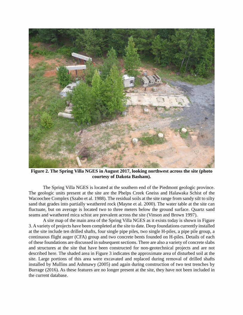
Figure 2. The Spring Villa NGES in August 2017, looking northwest across the site (photo
courtesy of Dakota Basham). The Spring Villa NGES is located at the southern end of the Piedmont geologic province. The geologic units present at the site are the Phelps Creek Gneiss and Halawaka Schist of the Wacoochee Complex (Szabo et al. 1988). The residual soils at the site range from sandy silt to silty sand that grades into partially weathered rock (Mayne et al. 2000). The water table at the site can fluctuate, but on average is located two to three meters below the ground surface. Quartz sand seams and weathered mica schist are prevalent across the site (Vinson and Brown 1997). A site map of the main area of the Spring Villa NGES as it exists today is shown in Figure 3. A variety of projects have been completed at the site to date. Deep foundations currently installed at the site include ten drilled shafts, four single pipe piles, two single H-piles, a pipe pile group, a continuous flight auger (CFA) group and two concrete bents founded on H-piles. Details of each of these foundations are discussed in subsequent sections. There are also a variety of concrete slabs and structures at the site that have been constructed for non-geotechnical projects and are not described here. The shaded area in Figure 3 indicates the approximate area of disturbed soil at the site. Large portions of this area were excavated and replaced during removal of drilled shafts installed by Mullins and Ashmawy (2005) and again during construction of two test trenches by Burrage (2016). As these features are no longer present at the site, they have not been included in the current database.

Figure 3. Site map showing currently installed foundations and approximate area of
disturbed soil. PREVIOUS SITE CHARACTERIZATION EFFORTS The largest characterization effort of the site was documented by Vinson and Brown (1997) and consisted of both in-situ and laboratory tests. This paper will focus on the in-situ tests. Vinson and Brown (1997) present in-situ results obtained from eight borings (B1-B8) and 14 CPTs performed around the site. Various in-situ tests performed in these explorations included Standard Penetration tests (SPT), CPTs, pressuremeter tests (including some CPT-mounted pressuremeters), dilatometer tests (DMTs), Iowa borehole shear tests (BSTs) and cross-hole shear wave velocity tests. Shear wave velocities were also measured using seismic dilatometer (SDMT) and seismic cone penetration test (SCPT). Table 1 summarizes the in-situ test type, reference and the boring or CPT number where the test was performed. The locations of the borings, CPTs (labeled as CPT-AU) and DMTs were digitized from the maps provided by Vinson and Brown (1997) and are shown in Figure 4. Figure 4 only shows the area of the site around the test foundations and thus does not show the location of all of the explorations. Additional CPTs have been performed at the Spring Villa NGES by Georgia Tech as part of two separate studies (Georgia Tech 2000 and McGillivray 2007). Several of these tests were seismic CPTs. These test locations were provided as latitude and longitude by the authors of those studies and are also listed in Table 1 and shown in Figure 4 (labeled as CPT-GT). Georgia Tech researchers performed additional CPTs at the Spring Villa NGES in 2016, which will be added to the database when they are published.
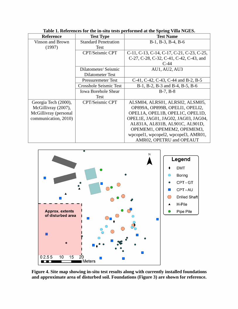
Table 1. References for the in-situ tests performed at the Spring Villa NGES. Reference Test Type Test Name
Vinson and Brown (1997)
Standard Penetration Test
B-1, B-3, B-4, B-6
CPT/Seismic CPT C-11, C-13, C-14, C-17, C-21, C-23, C-25, C-27, C-28, C-32, C-41, C-42, C-43, and
C-44 Dilatometer/ Seismic
Dilatometer Test AU1, AU2, AU3
Pressuremeter Test C-41, C-42, C-43, C-44 and B-2, B-5 Crosshole Seismic Test B-1, B-2, B-3 and B-4, B-5, B-6 Iowa Borehole Shear
Test B-7, B-8
Georgia Tech (2000), McGillivray (2007),
McGillivray (personal communication, 2010)
CPT/Seismic CPT ALSM04, ALRS01, ALRS02, ALSM05, OP899A, OP899B, OPELI1, OPELI2,
OPEL1A, OPEL1B, OPEL1C, OPEL1D, OPEL1E, JAG01, JAG02, JAG03, JAG04,
AL831A, AL831B, AL901C, AL901D, OPEMEM1, OPEMEM2, OPEMEM3,
wpcopel1, wpcopel2, wpcopel3, AMR01, AMR02, OPETRU and OPEAUT
Figure 4. Site map showing in-situ test results along with currently installed foundations and approximate area of disturbed soil. Foundations (Figure 3) are shown for reference.
The authors recognize that this data only includes a sub-set of the in-situ data that has been
collected at the Spring Villa NGES, but this represents the data for which accurate locations could be obtained. The authors reviewed additional publications, but many did not include maps or the map provided did not include any reference points which would allow it to be tied to the other site features. Additional results will be added to the database as they are identified and accurate locations for the tests are found. TYPES OF DEEP FOUNDATIONS The Spring Villa NGES was originally established as a test site for deep foundations in residual soils. To support this mission, several types of deep foundations have been installed at the site and many have been load tested in some manner. Table 2 lists the tested foundations that currently remain at the site. The locations of these foundations are shown in Figures 3 and 4. Each foundation is described in more detail below.
In addition to those listed in the table, two individual H-piles and 3 individual pipe piles are currently installed at the site. These foundations do not appear to have been load tested and the authors are not aware of any driving records or publications that describe the installation of these foundations. The pipe piles were left over after the removal of the first 12-pile group installed by Brown et al. (2001). The origin of the H-piles is unclear at this time.
Table 2. References for the foundations currently installed at the Spring Villa NGES. Reference Type of Foundation
Brown and Drew (2000) One 5-pile group (CFA piles) Brown et al. (2001) One 9-pile group (pipe piles) and
a single pipe pile Brown (2002) Ten drilled shafts
Marshall et al. (2017) Two H-Pile bents Pile Groups Brown and Drew (2000) describe the construction and testing of a pile group made up of five 0.45 m diameter DeWaal piles (displacement-type CFA piles) and a reinforced concrete pile cap. Only one group of CFA piles remains at the site although two are described in the paper. Unfortunately it is not clear which of these two groups remains at the site, so the exact properties are unknown. For both groups, the center pile was tested using a static axial load. The four surrounding piles were not tested. It is not clear when the pile cap was added or whether the piles were tested as a group. The coordinates of the center of the cap are provided in Appendix A.
Brown et al. (2001) describe the installation and testing of two pipe pile groups as part of a NCHRP study on lateral loading of pile groups. Thirteen instrumented steel pipe piles (0.27 m diameter and 12 m long) were used for the study. A 12-pile group and adjacent single pile were driven first and laterally loaded. The loading sequence was as follows: a static lateral load test was performed on the group using the DeWaal group as a reaction; dynamic loading of the group was performed in the opposite direction using a Statnamic test; a static lateral load test was performed on the single pile using the pipe pile group as a reaction. All 13 piles were then extracted and the piles were re-driven as a 9-pile group with a reinforced concrete cap and an adjacent single pile (this is the northern most pipe pile in Figures 3 and 4). The coordinates of the center of the concrete
cap for the pipe pile group are provided in Appendix A. The group and the single pile were then laterally tested using the same sequence described above. The three leftover piles were re-driven near the drilled shafts, but were not load tested. Details of the test results and instrumentation are described in Appendix E of Brown et al. (2001).
Drilled Shafts Brown (2002) describes the installation of the ten drilled shafts currently installed at the Spring Villa NGES. The shafts were all 0.9 m in diameter and 11 m deep and were constructed using either a casing advanced ahead of the hole or with drilling slurry (polymer or bentonite). The coordinates and identification (ID) numbers of the shafts (Figure 3) are also listed in the appendix. Details for the construction and testing of each shaft are listed in Table 3 along with the shaft names used by Brown (2002). Defects were placed in shafts 4 and 9. These defects consisted of sand bags tied to the rebar cage at a depth of 4 m for shaft 4 and a depth of 8 m for shaft 9. Further details on the construction of the shafts are given by Brown (2002). Each of the ten shafts was tested using a static axial load test (Brown 2002) and select shafts were tested using a static lateral load test (Simpson and Brown 2003). The axial load tests were performed against a reaction frame that was anchored using four CFA piles. The lateral load tests were performed in pairs by pushing the shafts together using a hydraulic jack on the outside of one of the shafts and tension bars between the two shafts. Movement of the shafts was monitored using both displacement transducers mounted to reference beams and inclinometers in the shafts. Details for each load test are given in their respective references. Anderson et al. (1999) also analyzed data from these load tests and correlated them with results from pressuremeter and dilatometer tests performed at the site. Table 3. Properties of the drilled shafts
ID Number2 (Figure 3)
Shaft Name1
Construction Technique1
Defect1 Axial Load Test1
Lateral Load Test2
1 24LP Polymer Slurry X X 2 24C Casing X X 3 24B Bentonite Slurry X X 4 1CDef Casing X X 5 1LP Polymer Slurry X X 6 24DP Polymer Slurry X X 7 1C Casing X 8 1DP Polymer Slurry X 9 24CDef Casing X X 10 1B Bentonite Slurry X
Sources: 1. Brown (2002) 2. Simpson and Brown (2003) H-Pile Bents Marshall et al. (2017) described the installation and testing of two H-pile bents at the Spring Villa NGES. Each bent consists of a reinforced concrete cap and four 35 foot long steel H-piles. The piles were installed using a vibratory hammer and each is embedded at least 20 feet in the ground. The north bent has four vertical piles; the south bent has two vertical piles, but the outer two piles were battered with a 1.5/12 slope. Both bents were laterally loaded using the 9-pile group as a

reaction. The movement of the piles was monitored using inclinometers and the forces in each pile were computed using strain gauges. Details on the construction and test results are given in Marshall et al. (2017). GIS DATABASE The above data has been input into a GIS database using ArcMap (ESRI 2015) to provide a single source for future researchers to find locations and information on each of the foundations and in-situ tests performed at the Spring Villa NGES. Coordinates were collected for each of the foundations by Auburn researchers in May 2017 using GPS survey equipment (Appendix A). Locations for the in-situ tests were either digitized from maps provided in the original references or were provided as latitude and longitude by the original authors. One of the challenges was finding maps that included common references such as CPT soundings or drilled shafts. Data that could not be accurately located using one of these methods was excluded from the database.
The foundations and in-situ tests were grouped by type and input as separate layers in the database to allow for different types of information to be stored about each. Discrete data such as pile length, tests performed and construction method were input into the database as attributes for each point. Other types of data such as load test curves and shear wave velocity profiles were attached to the points using images stored as raster data files. Links to the original reports and raw data (where available) were included for each point, so future researchers can quickly locate information not included explicitly in the database. DISCUSSION AND CONCLUSIONS Many previous research studies have been performed at the Spring Villa NGES, collectively representing a significant investment of time and money by multiple researchers and funding agencies. Despite this large investment, no previous database existed tying together the different locations of the tests that had been performed. The GIS database described in this paper bridges this gap by providing locations and relevant information about both the in-situ tests and foundations currently installed at the site. Disturbed areas of the site have also been delineated, so future researchers seeking undisturbed soil can avoid these areas.
Significant in-situ characterization of the Spring Villa NGES has been performed by past researchers (e.g., Figure 4), but much of this exploration has concentrated on the southeast corner of the site. Relatively few tests have been performed near the pile groups or pile bents where additional load test information is available. While the site is relatively homogenous, previous researchers have attributed some of the variation in load test data to site variability (e.g., Brown 2002). Should additional explorations be performed at the site in the future, researchers may consider placing some near these other foundations to quantify this variability and allow for more accurate correlations with the load tests on these foundations.
One of the major challenges is creating this database was finding accurate locations for the various explorations and foundations at the site. Most researchers published a map showing their individual investigations, but these maps did not always present coordinates or “permanent” items, such as the drilled shafts, which would have allowed for the map to be tied in with existing data. Even when common features could be identified, the process of digitizing the points introduces additional uncertainty that future users of the database must be aware of. Providing coordinates for future projects would make their inclusion in the GIS database much simpler. Auburn

researchers are in the process of establishing a benchmark at the site for use in future surveys. The GIS database for the Spring Villa NGES is currently available to researchers interested
in working at the Spring Villa NGES site. The database should be considered to be a living document and additional data will be added as it is made available. It is hoped that this database and the descriptions provided in this paper will allow future researchers to better utilize the site to develop and test methods for evaluating deep foundations in residual soils. ACKNOWLEDGEMENTS The authors are grateful to Dr. Dan Brown for providing records for many of the load tests and in-situ tests and to Dr. Alec McGillivray for providing information on the CPTs performed by Georgia Tech. Matt Barr, Jonathan Hogan and Michael Kiernan assisted with surveying the foundation locations. Dakota Basham provided the aerial photograph of the site. Funding for this study was provided by the Highway Research Center at Auburn University. The authors are grateful for all of this support. Any opinions, findings or recommendations expressed herein are those of the authors and should not be interpreted as representing the official policies, either expressed or implied, of this organization or the above individuals. REFERENCE Anderson, J. B., Grajales, B., Townsend, F. C. and Brown, D. (1999). “Validation of P-y Curves
from Pressuremeter and Dilatometer Tests at Auburn, Alabama.” Geotechnical Special Publication 92: Behavioral Characteristics of Residual Soils, ASCE, Reston, VA, 77-87.
Burrage, R. J. (2016). Full Scale Testing of Two Excavations in an Unsaturated Piedmont Residual Soil. Ph.D. Dissertation, Auburn University, Auburn, Alabama.
Brown, D. A. (2002). The Effect of Construction Technique on Axial Capacity of Drilled Foundations. Auburn University Highway Research Center, Auburn, Alabama.
Brown, D. A., O’Neill, M. W., Hoit, M., McVay, M., El Nagger, M. H., and Chakraborty, S. (2001). Static and Dynamic Lateral Loading of Pile Groups. Auburn University Highway Research Center, Auburn, Alabama
Brown, D. A., and Drew, C. (2000). “Axial capacity of augered displacement piles at Auburn University.” Proc., Geo-Denver 2000, ASCE, Reston, VA, 397-403.
ESRI (2015). ArcGIS Desktop: Version 10.3. Environmental Systems Research Institute. Georgia Tech (2000). “Seismic Cone Testing at Spring Villa NGES.” Georgia Institute of
Technology, <http://geosystems.ce.gatech.edu/Faculty/Mayne/Research/summer2000/ opelika/opelika.htm> (August 13, 2017).
Marshall, J. D., Anderson, J.B., Campbell, J., Skinner, Z., and Hammett, S.T. (2017). Experimental validation of analysis methods and design procedures for steel pile bridge bents. Auburn University Highway Research Center, Auburn, Alabama.
Mayne, P. W., Brown, D., Vinson, J., Schneider, J. A., & Finke, K. A. (2000). “Site characterization of Piedmont residual soils at the National Geotechnical Experimentation Site, Opelika, Alabama.” Geotechnical Special Publication No. 93 - National Geotechnical Experimentation Sites, ASCE, Reston, VA, 160-185.
McGillivray, A. V. (2007). Enhanced integration of shear wave velocity profiling in direct-push site characterization systems. Ph.D. Dissertation, Georgia Institute of Technology, Atlanta, GA.
Mullins, G. and Ashmawy, A., 2005. Factors affecting anomaly formation in drilled shafts - Final Report. University of South Florida, Tampa, FL.
Ogunro, V., Anderson, J.B., Starnes, J.R., and Burrage, R.E. (2008). "Characterization and Geotechnical Properties of Piedmont Residual Soils", GeoCongress 2008: Characterization, Monitoring, and Modeling of GeoSystems, ASCE, Reston, VA, 44-51.
Simpson, M., and Brown, D. A. (2003). Development of P-Y curves for Piedmont residual soils. Auburn University Highway Research Center, Auburn, Alabama.
Sowers, G. F., & Richardson, T. L. (1983). “Residual soils of piedmont and Blue Ridge.” Transportation Research Record, Transportation Research Board, 919, 10-16.
Szabo, M. W., Osborne, E. W., Copeland, C. W. Jr., Neathery; T. L., (1988). Geologic Map of Alabama, Special Map 220. Geological Survey of Alabama, Tuscaloosa, AL.
Waisnor, B. M., Ducote-Price, A., Jarosz, B., Duncan, J. M., & Smith, C. J. (2001). Geotechnical engineering within the Piedmont physiographic province. Center for Geotechnical Practice and Research, Virginia Polytechnic Institute and State University, Blacksburg, VA.
Vinson, J. L., and Brown, D. A. (1997). Site characterization of the Spring Villa geotechnical test site and a comparison of strength and stiffness parameters for a Piedmont residual soil. Auburn University Highway Research Center, Auburn, Alabama.
APPENDIX A This appendix gives the latitude and longitude (WGS 1984 coordinate system) for the foundations listed in Table 3. Additional information on the foundations can be found in the listed references. Table A1. Coordinates for the foundations currently installed at the Spring Villa NGES.
Description Latitude (WGS 1984)
Longitude (WGS 1984)
Installed Date
Reference
Drilled Shaft 1 (24LP) 32.59402 -85.29728 2002 Brown (2002) Drilled Shaft 2 (24C) 32.59410 -85.29726 2002 Brown (2002) Drilled Shaft 3 (24B) 32.59403 -85.29726 2002 Brown (2002)
Drilled Shaft 4 (1CDef) 32.59411 -85.29720 2002 Brown (2002) Drilled Shaft 5 (1LP) 32.59405 -85.29718 2002 Brown (2002)
Drilled Shaft 6 (24DP) 32.59396 -85.29726 2002 Brown (2002) Drilled Shaft 7 (1C) 32.59417 -85.29726 2002 Brown (2002)
Drilled Shaft 8 (1DP) 32.59398 -85.29721 2002 Brown (2002) Drilled Shaft 9 (24CDef) 32.59417 -85.29723 2002 Brown (2002)
Drilled Shaft 10 (1B) 32.59399 -85.29716 2002 Brown (2002) Pipe Pile Group (Center of cap)
32.59427 -85.29747 2000 Brown and O’Neill (2001)
CFA Pile Group (Center of cap)
32.59420 -85.29746 2000 Brown and O’Neill (2001)
Vertical H-Pile Bent (Center of cap)
32.59422 -85.29735 2015 Marshall et al. (2017)
Battered H-Pile Bent (Center of cap)
32.59415 -85.29733 2015 Marshall et al. (2017)


![Database (ppt) [updated]](https://img.pdfslide.us/doc/110x75/54ba72fd4a7959a4578b4644/database-ppt-updated.jpg)