Embed Size (px)
Citation preview
An Overview of Space Activitiesin the Netherlands
byJoost van Kasteren
HSR-27November 2002
a

ii
Short Title: Netherlands Space Activities
Published by: ESA Publications DivisionESTEC, PO Box 2992200 AG NoordwijkThe Netherlands
Editor: R.A. HarrisPrice: €10ISSN: 1683-4704ISBN: 92-9092-353-3
Copyright: © 2002 The European Space AgencyPrinted in: The Netherlands
iii
Contents
1 Prologue...............................................................................................................................1
1.1 Mapping the Universe .........................................................................................................11.2 Looking at Earth Itself ........................................................................................................11.3 Peaceful use ...........................................................................................................................11.4 Embryonic organisation ......................................................................................................2
2 First Steps ...........................................................................................................................32.1 Founding father ....................................................................................................................32.2 Attitude control ....................................................................................................................32.3 Useful experience..................................................................................................................4
3 Growing Up .......................................................................................................................53.1 Space plan..............................................................................................................................53.2 National enthusiasm.............................................................................................................53.3 Scientific interest ..................................................................................................................53.4 Deadline .................................................................................................................................63.5 Out of orbit............................................................................................................................63.6 Capability ..............................................................................................................................63.7 Education...............................................................................................................................63.8 Satellite laser ranging ..........................................................................................................73.9 Another satellite plan...........................................................................................................73.10 Benefits...................................................................................................................................73.11 Commercial involvement ....................................................................................................83.12 Spectacular ............................................................................................................................8
4 Coming of Age ..................................................................................................................94.1 Dwindling...............................................................................................................................94.2 Practical use ..........................................................................................................................94.3 No third satellite ...................................................................................................................94.4 Dismay..................................................................................................................................104.5 New objectives.....................................................................................................................104.6 Formalisation ......................................................................................................................114.7 From GROC to SRON ......................................................................................................114.8 National Space Agency ......................................................................................................114.9 Technology development...................................................................................................124.10 National Remote Sensing Board ......................................................................................124.11 Commercial interests .........................................................................................................12
iv
5 Focus ...................................................................................................................................155.1 Spacelab ...............................................................................................................................155.2 Robotic Arm........................................................................................................................155.3 Transportation....................................................................................................................165.4 Space research ....................................................................................................................165.5 Earth observation...............................................................................................................175.6 Eumetsat ..............................................................................................................................175.7 Telecommunications and navigation...............................................................................18
6 Conclusion ........................................................................................................................19
7 Sources ...............................................................................................................................21
Acronyms....................................................................................................................................23
Appendix I: Netherlands expenditure on space activities: 1972-2001..............25(million Euros)
Appendix II: Milestones in Netherlands Space History .........................................27
1
1 Prologue
In June 1655 Christiaan Huygens, the great Dutch mathematician, astronomer and physician, sent ananagram to John Wallis in London consisting of a verse of Ovidius and the letters uuuuuuu ccc rr h nb q x. The verse was Admovere oculis distantia sidera nostris, meaning ‘distant stars move towardsour eyes’. Both verse and letters combined into: Saturno luna sua circumducitur diebus sexdecimhoris quatuor meaning ‘around Saturn its moon circles in sixteen days and four hours’. With thisanagram Huygens claimed his discovery of Titan, the largest moon in our solar system.
As a seafaring nation the Republic of the Netherlands showed great interest in the movement ofcelestial bodies, mainly for position determination. In the 17th Century there were already severalinstruments (telescope, sextant) which could be used to ‘shoot a star’, but in order to derive yourposition from that you needed to know the positions of the stars. This practical need formed the basisof the long-standing tradition of astronomical research in the Netherlands of which Huygens was ashining example.
1.1 Mapping the Universe
An important Dutch astronomer is Jacob Kapteyn who derived a model of the Universe from picturestaken at the Cape of Good Hope in South Africa. Although in the end it proved to be wrong, the modelplayed an important role in the astronomical debate in the 1920s, a debate that led to our moderninsights in the structure of the Galaxy. One of his pupils was Hendrik Jan Oort who mapped the spiralstructure of the Galaxy with the help of the then newly discovered radio wave detector. He alsodiscovered the Oort Cloud at the edge of the solar system where comets reside. Gerard Kuiper, aDutch-born American astronomer gives his name to the Kuiper Belt, a zone past Neptune which isconsidered the source of short period comets.
The mapping work of Oort would not have been possible without the use of radio emission. AnotherDutch astronomer, Henk van de Hulst, suggested the use of the 21 cm spectral line of atomic hydrogenas tool for the mapping of the Universe. In 1957 a radio telescope was built in Dwingeloo and in 1970an array of 14 radio telescopes was built in Westerbork, 25 km from the first one. In 1990 theWesterbork array became part of a European network for Very Long Baseline Interferometry, whichmakes it possible to pick up radio signals from the end of the Universe. The headquarters of theEuropean network for VLBI are in Dwingeloo.
1.2 Looking at Earth Itself
Astronomy research was an important driving force behind the first space activities in the Netherlands,but not the only one. From the end of the 19th century onward the Netherlands was also involved ingeophysical research, especially the First (1882-1883) and Second (1932-1933) Polar Year and theInternational Geophysical Year (1957-1958). It was the Dutchman Vening Meinesz who, based on hismeasurement of the Earth’s gravitational field, suggested that convection flows in the outer layers ofthe Earth’s mantle were responsible for the movement of the continental shelves thus supportingAlfred Wegener’s theory of plate tectonics. Other research areas that enhanced the interest in spacewere meteorology, oceanography and research into the upper layers of the atmosphere, the ionosphere.
The suggestion to set up an international sounding rocket programme as part of the InternationalGeophysical Year was hence welcomed by the Netherlands research community. The programmeincluded the launch of a satellite to gather data from the upper layers of the atmosphere. The USVanguard had been developed for that purpose and was supposed to be put into orbit in the spring of1958. On 4 October 1957, however, everyone, including the geophysicists, was surprised by thelaunch of Sputnik-1 by the USSR, exactly 40 years after the October Revolution of 1917. The firstVanguard satellite was launched in March 1958, only a few months after Sputnik-1, but in the tensecold War period of the 1950s and 1960s Sputnik-1 was enough to start the ‘Space Race’ that resultedin the Apollo-programme for manned space flights and the first steps on the Moon in 1969.
1.3 Peaceful use
As already indicated, the impact of the launch was enormous, not only among politicians and themilitary but also among scientists. They already had presumed that satellites would greatly enhance
2
their means of exploring space, but the successful launch of Sputnik and shortly afterwards the firstVanguard (which still is orbiting Earth) really opened up space, at first mainly for research, but lateralso for commercial purposes.
Scientists in the Netherlands were very keen on the peaceful use of space. In November 1958, Van deHulst – at the instigation of Oort – attended a meeting in London of the International Council ofScientific Unions (ICSU). A week later he came home as the first president of COSPAR, theCommittee for Space Research of ICSU, aimed at the peaceful exploitation of space. The ICSU wasworried that, in the upcoming rivalry between the USA and the Soviet Union, the military aspects ofspace studies would take priority over the scientific ones. The fact that this did not happen (eventhough the military importance remained great) must have been at least partly due to COSPAR. At aCOSPAR congress Van de Hulst presented a Dutch wooden shoe (clog), cut from wood of the sametree, to two astronauts (Glenn from the USA and Titov from the Soviet Union). The symbolism wasunderstood by everybody.
1.4 Embryonic organisation
In 1959 Van de Hulst took the initiative to form the Netherlands Geophysics and Space ResearchCommittee (GROC) as part of the Royal Netherlands Academy of Sciences (KNAW). This committeewas to co-ordinate the space research carried out by the astronomers and geophysicists in theNetherlands. It managed to get government funding for space research and it represented theNetherlands in several international organisations. Van de Hulst remained the Chairman of GROCuntil it was superseded by SRON (Space Research Organisation of the Netherlands) in 1983.
GROC consisted mainly of the Astronomy Departments of the University of Utrecht (Solar and StellarSpace Research); the University of Leiden (Cosmic Rays); the University of Groningen (Photometry)and the research group on Satellite Geodesy of the University of Technology Delft. The GROCresearch groups took part in several rocket and balloon experiments. The instruments used weredesigned and developed by the university groups themselves, assisted by industry and technicallaboratories.
Although small-scale rocket tests were performed at the island of Texel in the 1950s and 1960s(mainly for ballistics research) the Netherlands did not until then have a tradition in rocket researchand development, except for one notable exemption: in 1946 J.M.J. Kooy and J.W.H. Uytenbogaertpublished ‘Ballistics of the Future’ a now classic book on space flight dynamics. The book was for alarge part written during the Second World War when Kooy observed the launch of V-2 rockets nearhis home in The Hague. Kooy became professor at the Royal Military Academy in Breda in 1967 andwas Chairman of the Netherlands Astronautical Society. For many years he published articles on spaceflight, specifically on the stability of lunar orbits. A fund that carries his name supports research onballistics and related fields to this day.
3
2 First Steps
From the start it was clear that the Netherlands’ contribution to space exploration could only takeplace through cooperation. The country just did not have the capacity to go its own way. Apart fromthe superpowers, the USA and the USSR, other countries were in the same position, so Europeancooperation seemed the obvious choice. The Dutch already were avid supporters of Europeancooperation in general, which was beginning to emerge in the 1950s. In 1951 the Netherlands hadbeen one of the six countries that signed the ECSC Treaty (European Coal and Steel Community) andin 1957 the EEC Treaty of Rome (European Economic Community) was signed. It was thus nowonder that Dutch space enthusiasts turned to their European colleagues.
2.1 Founding father
The signing of the Meyrin Treaty in 1961, named after the Swiss town of Meyrin, was a result ofdiscussions and meetings held since 1958 and it led to the founding of the Commission PréparatoireEuropéenne de Recherche Spatiale (COPERS). The committee’s brief was to prepare a EuropeanSpace Research Programme. In that same year GROC, together with the Netherlands Agency forAircraft Development (NIV) addressed the Netherlands government with a plea to take part in theEuropean space cooperation. They found a sympathetic ear and consequently the Netherlands becameone of the founding fathers of the European Space Research Organisation (ESRO), founded in June1962. The Netherlands’ share amounted to 4.24 percent.
A few months before the official signing of the ESRO Treaty, in April 1962 it was decided that thetechnology centre of the organisation, ESTEC, would be based in the Netherlands. ESTEC isresponsible for managing space projects and the preparation of future projects, supporting (ESA-)project teams and the development of new space technology. In 1962 the organisation was temporarilyhoused in buildings of the University of Technology in Delft, but these soon proved to be too small forthe increasing number of people that came to work for ESTEC. Furthermore the ground in the polderwhere the University was located was too unstable to build test facilities. At a meeting of the ESROCouncil in June 1964 it was decided that ESTEC would be based somewhere else.
The Netherlands government proposed the coastal town of Noordwijk and construction there started in1965. Two years later, in April 1967, Princess Beatrix (now Queen of the Netherlands) officiallyopened the buildings. Scientists from the Netherlands were from the start actively involved in ESRO-projects and scientific instruments were delivered for ESRO satellites like ESRO-2 and 4 and TD-1(1968-1972).
Nowadays about 1600 people are working in Noordwijk; 1000 staff of ESA and 600 people employedby various other agencies and industries. The exhibition ‘Space Expo’, also housed in Noordwijk closeto ESTEC, is a popular destination for family outings.
At the same time ESRO was being formed (1960) the United Kingdom and France had started todiscuss the possibilities regarding the development of a satellite launching system. Both countrieswere already developing such a system (Blue Streak in the UK and Coralie in France, while Germanywas building Astris) but the burden for each of them became too heavy. Other countries got involvedand in March 1962 the Netherlands was one of the seven countries to sign a convention with the aimof designing, constructing and launching rockets for spacecraft. The new organisation was namedELDO, European Launcher Development Organisation and the Netherlands’ share was 2.6 percent.
2.2 Attitude control
The work within ELDO was roughly divided between the participating countries. The Netherlands hadto develop and manufacture equipment for long-distance telemetry and to test the Attitude Referenceand Programme Unit (ARPU) and, later on, the inertial guidance system. The latter task was done bythe National Aerospace Laboratory (NLR), which also carried out wind tunnel tests. The developmentof long distance telemetry was assigned to Philips Telecommunications Industry (PTI) in Hilversum.
The ARPU used a gyroscopically stabilised platform, which provided a reference point for derivingthe attitude of the rocket in space. It was tested on a hydraulically controlled rocking table with threedegrees of motion, with which the rotational motions of the rocket could be simulated. The hydraulic
4
cylinders were controlled by an analogue computer on which the equations of motion and thecharacteristics of the rocket steering mechanism were simulated.
Fully analogue computation was needed because in those days the speed of digital computers was notsufficient to process the equations of motion and control equations in real time. In later versions of theELDO rockets the gyroscopically stabilised platform was replaced by an inertial system usingaccelerometers. These were also tested by NLR by providing them with signals from the computationsthat simulated accelerations during actual flight.
Apart from the attitude control system for the rocket, NLR, Philips and Fokker were also responsiblefor developing a similar system for the ELDO-PAS project (Perigee-Apogee Satellite) whereby apayload was to be carried into an elliptical orbit with its highest point (apogee) at the altitude for ageostationary orbit. At this point the satellite would be released into that orbit. The project wascancelled, but the experience gained was valuable for the emerging Dutch space-related industry.
2.3 Useful experience
It can be said that, although ELDO was not very successful with respect to its launches (according tosome it was an expensive experiment in international cooperation that did not work out very well) itlaid the grounds for the development of Ariane. Further on it provided Dutch participants like Philips,NLR, TUD, TNO and Fokker with a lot of technical and operational expertise that has also been usedfor Ariane. The experience gained in international cooperation – although quite frustrating at times –also proved to be very useful, especially when the Netherlands began to think about building its ownsatellite.
5
3 Growing Up
By the mid-1960s it was becoming clear that the Netherlands commercial sector was not verysuccessful in obtaining orders for European space projects, at least not the orders that weretechnologically challenging. Under the ESRO/ELDO agreements the contribution of each country tothe budget of the European organisation determined the value of the contracts awarded to this countryso the money spent came back anyway. The problem was that it did not do very much for the buildingof technical and operational capacity.
3.1 Space plan
The obvious solution was to build your own satellite, thus showing to the world that the Netherlandshad the technical and managerial capacity needed for space exploration. A working group,spontaneously formed by representatives from Fokker, Van der Heem Electronics and Philipssubmitted a proposal to develop such a satellite in 1966: the Netherlands Astronomy Satellite. Withthe proposal the industries involved in space research and development reacted to a call from theDepartment of Economic Affairs regarding suggestions for a national space plan. AnInterdepartmental Commission for Space Research and Technology (ICR) had been set up in March1966 to co-ordinate activities in the Netherlands. A first plan was presented in September a year later.
Not only was the ICR presented with a plan for a Netherlands Astronomy Satellite, but the commercialsector together with the PTT (the Netherlands’ mail and telephone company, at that time stillgovernment-owned and operated) submitted a proposal to build an experimental ground station forsatellite communication. The ground station was opened in 1973 by the then Queen Juliana near thevillage of Burum in Friesland in the north of the Netherlands, not on an experimental basis but as thefirst operational ground station for Intelsat-1, which had been launched in 1965. Burum is still themain ground station for satellite communications. The 25 hectare area with its dozen dishes is aptlycalled ‘it Greate Earen’ (the great ears) in the local Frisian language.
3.2 National enthusiasm
As the proposed satellite and ground station would lead to a substantial increase in spending on spacethe government sought the advice of the Science Policy Council (RAWB). In 1968 the Councilrecommended to go ahead with both projects and to stay involved in European programmes. In 1969 asecond advice of the Science Policy council was published as a reaction to the preliminary study forthe Netherlands Astronomy Satellite or ANS (Astronomische Nederlandse Satelliet). In this documentthe RAWB proposed to improve the situation of the Dutch space industry. An astronomical satellitewould be an excellent object for a national space plan. There were several arguments.
First of all Dutch astronomers had a reputation to uphold; a satellite would further boost thatreputation. Secondly, space is so enormously vast that the overlap with other space research initiativeswould be limited. A third reason for choosing an astronomical satellite was that astronomical researchwas quite popular among the public. A satellite could possibly lead to some ‘national enthusiasm’.Last but not least, an astronomical satellite would give ample opportunity to show Dutch ingenuitywithout the complications that arise from international cooperation.
3.3 Scientific interest
Dutch astronomers were asked to develop research experiments that could be carried out with this nottoo heavy satellite (<112 kg), which also should not be too expensive. The scientists suggested tomeasure the following:• ultraviolet radiation of hot stars, between 1500 and 3300 Å;• weak stellar X-rays, between 44 and 55 Å;• hard solar X-rays between 0,3 and 6 Å;• hard stellar X-rays, between 2 and 34 Å.
Scientific interest was enormous. Earlier attempts like the Uhuru satellite from NASA had revealedthat there were quite a few X-ray sources in the Universe. The suggested X-ray telescope on theNetherlands satellite was supposed to reveal many more, but also to provide more information on
6
these sources, for instance their periodicity. The monitoring of the far ultraviolet was expected toreveal information on the process of star formation. A special feature of the proposed satellite was aprogrammable onboard computer that could be reprogrammed every 12 hours for optimalmeasurement of ultraviolet and X-ray sources in space.
3.4 Deadline
After a preliminary study, the Netherlands government decided in December 1970 to build theNetherlands Astronomy Satellite or ANS (Astronomische Nederlandse Satelliet) with the NetherlandsAgency for Aerospace Programmes (NIVR) as the supervisor. Fokker and Philips established theIndustrial Consortium Netherlands Astronomy Satellite (ICANS) which worked closely with theLaboratories for Space Research of the Universities of Groningen and Utrecht. Together theysucceeded in building the satellite within the five-year deadline. With the proverbial Dutch thriftinessthe costs were kept to a minimum. The whole operation would cost a mere 36 million Euro.
The instruments on ANS consisted of an ultraviolet telescope designed by the Space Research Groupof the University of Groningen and built by Ball Brothers Research Corporation in the USA, two X-ray detectors built by the Space Exploration Laboratory of the University of Utrecht for measuringsoft and hard X-rays and an X-ray detector built by a US consortium which included MIT (theMassachusetts Institute of Technology) and the Centre for Astrophysics. The ANS was tested byNIVR with help from ESTEC in Noordwijk, NLR and the German DFVLR.
3.5 Out of orbit
On the 30th of August 1974 ANS was launched from the Western Test Range in California. During thelaunch there was a deviation in the launch path of the SCOUT-rocket, which resulted in an alterationin the orbit of the ANS. Instead of an almost circular orbit between 510 and 560 kilometres thesatellite went into an elliptical orbit between 260 and 1160 kilometres high. At first it looked like adisaster but, thanks to the programmable computer on board, the attitude control system could beadjusted to give the desired observation programme, even in these extreme circumstances. The onlything was that a group of staff and students at Delft University of Technology (TUD), had to workovertime to calculate the exact attitude and position of the satellite.
Almost three years later, in July 1977, ANS returned into the Earth’s atmosphere. It was kept inoperation between September 1974 and December 1975 and turned on again shortly in March andApril 1976. ANS is still considered a great success. First of all because of the scientific results thatwere obtained. Both the X-ray and ultraviolet measurements have produced a lot of data, amounting toyears of work. Three new types of X-ray sources were identified and the ultraviolet spectrometerproved the existence of very hot stars in our galaxy.
3.6 Capability
Apart from the scientific results ANS also demonstrated the technological capability of theNetherlands. Although the different systems on board were designed for a six months lifetime theylasted for nearly three years. The attitude control worked better than expected; the aiming accuracywas designed to be one arc minute but turned out to be 30 arc seconds.
The scientific, technological and operational success of the ANS-mission established the Netherlandsas a space-faring nation. Add to that the fact that, compared with other space projects, the ANS wascarried out on a shoestring then it is no wonder that it invited some technologically challenging ordersfrom ESA, NASA and others for years to come, not only for advanced instrumentation but also forsolar arrays, robotics and attitude control systems. An evaluation study revealed that ANS had fulfilledits expectations with respect to its scientific and technological goals and the increased competitivenessof Dutch industry.
3.7 Education
Around the time that the government decided to go ahead with ANS, TUD started with a new courseon space technology within the Department of Aeronautics, at that time still part of the Faculty ofMechanical Engineering. The establishment of this course followed a suggestion by Henk van deHulst, who around 1965 had gathered a few university staff members to discuss the need for academictraining in space technology.
7
In 1970 the number of new students entering the Department increased dramatically, following thesuccessful flight of Apollo-11 in 1969, which put Armstrong and Aldrin on the Moon. In 1975 theDepartment of Aeronautics became a full-fledged Faculty of Aerospace Engineering, illustrating theimportance of space technology for industry and society as a whole.
In 1996 the university started a post-graduate course in space systems management. This SpaceTechcourse is developed in cooperation with the commercial sector, scientific organisations and ESA andleads to the degree of Master of Space Systems Engineering. By 2001 about 80 people had taken partin the course.
3.8 Satellite laser ranging
As ANS was launched another event took place, which attracted a lot less publicity; the start ofsatellite laser ranging at a new Observatory for Satellite Geodesy, in Kootwijk, a village located on theedge of the Veluwe National Park. The start of the Observatory marked the importance of space forgeophysics. Even before 1957 geophysicists had realised the importance of satellites for triangulation,the measuring of distances on Earth. By using a satellite’s position, triangulation points hundreds ofmiles apart, could be connected.
Geoscientists from TUD started using satellites for triangulation in 1961. At first existing satelliteswere used by photographing them against the night sky. Comparing the photographs of severalstations gave a very precise triangulation and hence a good estimate of distance between the stations.Later on, in the beginning of the 1970's, the technique of satellite laser ranging was used. A laser beamis emitted towards a special reflecting satellite (LAGEOS), reflected and received again by atelescope. By sending (and receiving) laser beams from separate stations at exactly the same time,distances can be measured on the Earth’s surface with an accuracy of 5 centimetres. To avoiddifficulties with timing, an innovative method was developed in Delft to calculate exactly the distancethe satellite had covered in between two laser beams.
Among other things the satellite laser ranging system has been used to measure the movement ofcontinental plates in the Mediterranean and to verify the position of the satellites used for the UnitedStates Global Positioning System. Early in the 1990s the observatory in Kootwijk was closed;triangulation is now done by radio telescopes using quasars as their reference point.
3.9 Another satellite plan
ANS qualified the Netherlands as a fully-fledged space nation. Although this led to some veryinteresting assignments, the size of the Netherlands contribution in ESA (which was formed in 1975 asa successor of ESRO/ELDO) remained small – too small to earn overall systems responsibility for oneof the ESA projects. Therefore it was no surprise that after the successful ANS mission the Dutchastronomy community and space industry submitted a proposal for a new national satellite, this timemuch larger than ANS.
As with ANS the question was, what kind of satellite would boost astronomical research in theNetherlands without duplicating other initiatives. One of the areas that proved interesting was theinfrared wavelength between 8 and 100 µm. At that wavelength radiation is emitted from so-called‘cool’ objects, cool meaning a temperature between 10 and 2000K. Planets are cool objects, but so aredust clouds in the farther regions of space. It was thought that by exploring these objects, informationcould be obtained on the formation and death of stars and the formation of planetary systems.
No such survey had been carried out at that time and – as previous endeavours had shown –unexplored regions of the electromagnetic spectrum could reveal quite exciting phenomena.Exploration of infrared sources is impossible from Earth, due to obscuration of the signal by thermalradiation from the telescope and its surroundings. An infrared telescope on a space platform was veryattractive to astronomers. The objective of the Infrared Astronomy Satellite (IRAS) was to survey atleast 95% of the sky for sources of infrared radiation, but mainly in the Milky Way region.
3.10 Benefits
In 1975 a preliminary study for IRAS was made, resulting in a proposal from the NIVR to build such asatellite. The proposal was supported by a study on the ‘Potential benefits to the Netherlands from theIRAS-project’, carried out by a British consultancy firm. They advised the Netherlands government toincrease spending on space activities so that industry and society as a whole would benefit from the
8
strengthening of the technological capacity. At that time the Netherlands were spending about 0.03%of the Gross National Income on space-related activities. According to the British consultants this hadto more than double to 0.08% to keep up with other nations. IRAS was an excellent object to spendthis extra money on.
In 1976 the government gave IRAS the green light. The project began with an agreement, between theNIVR and NASA, for the Netherlands to provide the spacecraft and be responsible for the testing, thesystem integration and the operation. NASA would provide the telescope, the launcher and the dataprocessing equipment. The Space Exploration Group of Groningen University would build a series ofspectrometers, together called DAX, short for Dutch Additional Experiment. As the Netherlands didnot have in-house capacity for operating the satellite, the UK Science and Engineering ResearchCouncil got involved. They would provide the necessary facilities in exchange for a piece of the pie,i.e. the participation of British astronomers in the survey.
3.11 Commercial involvement
As with ANS the Netherlands commercial sector was heavily involved in IRAS via an industrialconsortium (ICIRAS). The ICIRAS consisting of Fokker and Hollandse Signaal Apparaten wasresponsible for the project management in the Netherlands. In the USA project management wasallocated to the Jet Propulsion Laboratory (JPL) and in the UK the Rutherford Appleton Laboratorymanaged the British part of the project. Overall project management was put in the hands of the JointIRAS Project Executive Group (JIPEG) which consisted of the representatives of the differentinstitutes involved and of the Joint IRAS Science Working Group.
IRAS was a much heavier (1080 kg) and much more complicated satellite than ANS (140 kg). It was acylindrical structure, the base of which housed the spacecraft platform with all the necessaryhousekeeping and control tasks, like power distribution, attitude control, data storage andcommunication. The remainder of the cylinder housed the telescope, consisting of an optical systemwith two mirrors in a tank filled with liquid helium. Several detectors were mounted in the focal plane.
The helium was used to cool the detectors to a temperature of about 2K and to keep the inner walls ofthe telescope at a temperature of about 10K to obtain the desired sensitivity for the observations. Theselow temperatures were a technological challenge in the sense that electronics and materials behavequite differently. IRAS had 75 kg of helium which would last for about 300 days of operation.
3.12 Spectacular
After being postponed a number of times, due to problems with the cryogenic system, IRAS waslaunched with a Delta rocket on 25 January 1983 from the Western Test Range in California. Once inits Sun-synchronous near polar orbit the satellite operated smoothly until 22 November 1983 when itran out of helium. The results of the IRAS mission were spectacular. For instance it was discoveredthat in some galaxies the infrared radiation is about 500 times larger than in our own galaxy, meaningthat a lot of new stars are being formed in these galaxies. Its infrared map of the Galaxy is still in use.IRAS also showed that planets are forming around other stars in the Universe. Or, to quote from theUS National Commission on Space: ‘The Infrared Astronomy Satellite discovered that dozens of starshave clouds of particles surrounding them, emitting infrared radiation; astrophysicists believe thatsuch clouds represent an early stage in the formation of planets.’
9
4 Coming of Age
The IRAS mission marked the coming of age of space activities in the Netherlands – a shift from thepioneering stage, with its emphasis on scientific research, to a situation in which space activities havebecome ‘normal’. At the same time space activity has broadened to include practical applications, suchas telecommunications, earth observation (including weather forecasting) and the use of microgravityfor biological and material science experiments.
4.1 Dwindling
This change in both position and scope was marked by a White Paper published by the Netherlandsgovernment in 1982 called: ‘De ruimtevaart in de jaren ‘80’ (‘Space in the eighties’). It stated that upto that point the Netherlands’ space policy had merely been an extrapolation of developments that hadstarted in the late 1950s. It also stated that the time had come to formulate a long-term policy, basedon strategic choices. These choices were necessary because of the limited financial means of theNetherlands government, but also because spaceflight had to prove its worth, not only for scientistsbut for society as a whole.
This proof was needed because after the spectacular successes of manned space flight, the publicsupport for space activities was beginning to dwindle. This downward trend was reinforced by a verycritical attitude towards technology in those days, ignited by the incident at the Three Mile Islandnuclear power plant in the USA and fed by bleak stories of environmental deterioration. According tosome, the mood of the day was very anti-technology. Being a spearhead of technological developmentspace activities hence came under fire. They seemed a luxury; a lot of money spent on the hobbies ofsome ‘space addicts’.
The White Paper on Space in the eighties had already been announced in 1977 by the then Minister forScience Policy. It took almost five years to complete because a radical change in attitude towardsspace activities was required. Instead of going with the flow, policy makers had to evaluate in detailthe economical, environmental and technological effects of space exploration. An additional problemwas that the Netherlands, being a relatively small space nation, could not formulate its own strategywithout knowing the future plans of ESA. However it took ESA until 1980 to formulate a long-termstrategy for its activities, the process being complicated because the large member states of ESA hadtheir own national programmes and hence their own agendas.
4.2 Practical use
The policy document analysed the importance of space for the Netherlands. It pointed out thattelecommunications was the most developed space application at the beginning of the 1980s.Communication satellites were already being exploited on a commercial basis. Taking part in the L-Sat programme (later, Olympus) opened up the possibility for the Netherlands industry to gain a shareof the satellite market. Less developed but still quite interesting were the emerging possibilities withrespect to the observation of the Earth or ‘teledetection’ as it was called in those days. It was deemedespecially useful for the monitoring of environmental and ecological trends and agriculturaldevelopment. This would not just be useful for the Low Countries themselves but also as a means toinstigate development in the Third World. With the International Institute for Aerospace and EarthSciences (ITC) in Enschede, established in 1950, the Netherlands would have a strong position in thetransfer of knowledge of geosciences to Third World countries.
With regards to space-related science the Netherlands traditionally had a strong position in the field ofastronomy, a position that had been further strengthened by the ANS and IRAS missions. Spacelabprovided the opportunity for other disciplines to do new and fundamental research in space, inparticular biological and materials research.
4.3 No third satellite
Considering these developments and considering the limited financial resources for space activities theNetherlands government decided that there was no room for a third Netherlands scientific satellite.Netherlands industry and institutions had made their mark internationally with ANS and IRAS. Theadded value of designing and building such a satellite would be too small to justify the costs of – at
10
that time – 90 million Euro. More practical satellite systems, for instance for telecommunications orEarth observation, required investments that went well beyond the Netherlands space budget.
It was decided that the relatively modest amount of money available (40 million Euro per year) wouldbe better spent by taking part in international projects. The projects of choice would mainly be ESAprojects, with an emphasis on applications, such as telecommunications (L-Sat at that time) and Earthobservation (ERS). The space policy would also attempt to stimulate bilateral projects and theparticipation of the Netherlands industry in commercial projects. The application to other fields of theknowledge and experience gained in space projects would also be stimulated.
4.4 Dismay
The Netherlands space community – including astronomers – reacted with dismay to the government’sdecision. Several people in industry and university pointed out that without a Netherlands satelliteproject the experience with systems integration and management of complex technological projectswould be lost. Instead of being the main contractor on such projects, the Netherlands industry wouldbe demoted to the role of subcontractor, dependent on the whims of foreign companies andorganisations.
Several studies had already been performed on possible satellite projects. One such project was abroadcasting satellite, NETSAT. It never got beyond the discussion stage, because in 1979 the L-Satprogramme was launched by ESA. In that same year a feasibility study was undertaken regarding asuccessor to ANS, the TIXTE (Timing and Imaging X-ray Transient Explorer) which would carry anImaging Wide Angle Camera for X-ray Sources (IWACXS). NASA was interested and the BritishSERC also wanted to join in. The NIVR, in co-operation with NASA's Goddard Space Flight Center,conducted a feasibility study. But as the political climate in the Netherlands was changing and thesupport for a national satellite diminished the TIXTE project was abandoned before it had even begun.
Another project that was shelved around that time was TERS, the Tropical Earth Resources Satellite,an Earth observation satellite to be developed together with Indonesia, a former Dutch colony and apartner in development. Discussions between the Netherlands and Indonesian Aerospace Agencystarted in 1978 and in 1979 a workshop was held in Jakarta. While the Netherlands industry startedwork on a provisional definition study, the enthusiasm in Indonesia appeared to be waning. In 1981though the Indonesians announced that they wanted to become involved again and in 1984 thedefinition study was concluded. A year later a proposal was made for a systems study. At that timeBelgium was also interested in joining because of the satellite’s potential application in EquatorialAfrica. However, no agreement could be reached on the financing of the project. It was discontinued.
4.5 New objectives
At the beginning of the 1980s, when the new Netherlands space policy was formulated, its main aimhad been to use the unique possibilities of space for social and economic well-being and scientificprogress. This objective consisted of several sub-objectives, which can be grouped in three categories;political objectives, user objectives and industrial/technological objectives.
The political objectives were and still are:• to maintain independent European access to space;• effective international technological cooperation;• participation in the building of a European space capacity;• to contribute to solving global problems.
The user objectives are divided into scientific, institutional and industrial/technological use.Scientifically the aim of the Netherlands is to perform ground-breaking research in and on space.Institutionally this means that the necessary infrastructure should remain available both in space andon Earth, including a user infrastructure to guarantee the availability of data and data products. On theindustrial/ technological level private companies should be stimulated to either take part in buildingthis type of infrastructure and/or to use the data generated.
The industrial/technological objectives are:• to improve technological innovation and competitiveness of the Netherlands industry, by allowing
access to space technology;
11
• to help use the knowledge and experience gained in developing commercial products andservices;
• to promote co-operation between companies and public institutes at both national andinternational levels.
Since then these objectives have led to a space policy in which the focus lies on European co-operationthrough ESA, Eumetsat and the EU. The Netherlands contribution in the optional part of theseprogrammes was defined by priorities set by users and by industry. These priorities were supported byactivities at a national level, e.g. the use of Earth observation data and the development of advancedtechnology. Apart from that, the government aims at developing a market for institutional andcommercial use of space and for the transfer of knowledge to small and medium-sized companies.
4.6 Formalisation
Together with the formulation of a space policy the institutions became more formalised. In the earlydays space policy and funding of space activities was the responsibility of the Minister of EconomicAffairs and the Minister of Science Policy. As it became clear that space activities were also importantfor other areas of government, more ministers gradually became involved.
As mentioned before, in 1966 an Interdepartmental Commission for Space Research and Technology(ICR) was established to formulate the Netherlands Space policy, advise the government onparticipation in international programmes and co-ordinate the Netherlands position in ESA (then stillESRO/ELDO). This ICR was given a more formal role in the policy document of 1982. The numberof participating departments increased to nine and the tasks and competences of each of these wereformulated. At first the Minister of Science Policy held the presidency of the ICR. Later on theMinister of Economic Affairs held this post; another illustration of the switch from a pioneering,research-oriented space community to a more established and application-oriented organisation.
Some people regret that the days of pioneering are now over and are of the opinion that space is nowbeing controlled by bureaucrats. Other people, for instance the young space professionals that tookpart in the Vision 2020 project of the International Space University in 1995, want to use space andspace technology for the benefit of all mankind and want to be held accountable for that.
4.7 From GROC to SRON
Not only the ICR but also the positions of its advisory bodies were evaluated and consequentlyupdated. One of these was the GROC of the Royal Netherlands Academy of Science. Since its start in1959 it had operated on an ad hoc basis, working on a project basis, both internationally as well as atnational level. This ad hoc character also had an effect on the organisational structure of the committeeand on the financing of projects.
In 1982 when the space policy document was published, the first steps had been taken towards thecreation of a more formal institution. The GROC was discussing with the Netherlands Organisationfor Scientific Research (NWO) about becoming a foundation within the framework of this parent-organisation, which was mainly government-financed. This would be identical to the way othersciences, such as physics were structured. One of the underlying thoughts was that by embeddingGROC in the regular science institutions it would become easier for other scientists to get access tospace. This was the more urgent because of the Space Research Module Spacelab with its possibilityfor research on fluid dynamics, physiology and other interesting research areas. For researchers inthese fields the step into space was still quite big. It was thought that a ‘new’ GROC could bridge thisgap more easily.
Hence in 1983 the acronym GROC was changed into SRON, a foundation within the framework ofNWO with a more formal organisation and – although still based on projects – a bit less ad hocregarding its financing.
4.8 National Space Agency
In 1970, at the time the Netherlands government gave the go-ahead for ANS, it was also decided thatthe NIV would co-ordinate space activities in the Netherlands. As with all the other projects, aworking group was set up. In July 1970 it presented its proposal to include spaceflight in the agenda ofthe Agency. In 1971 the name of the agency was changed into the Netherlands Agency for AerospaceProgrammes (NIVR).
12
In those days, the space activities of NIVR were primarily concerned with the management of theANS project. Apart from that studies were made on space activities and on the development of spacetechnology in the United States, the Soviet Union and Europe. These included the potential value ofspace and space technology for the economy and for society as a whole. Following these studies theNIVR started in 1979 with its – government financed – NIVR Space Technology programme (NRT)aimed at funding research on promising space technology and products.
4.9 Technology development
Over the years the Space Technology programme has been important in strengthening the position ofNetherlands industry and research institutes, both as part of ESA programmes and in commercialspace activities. One of the successful products developed within the Space Technology programmewas a solar panel, the Advanced Rigid Array (ARA) developed by Fokker Space & Systems (nowFokker Space). The ARA, completed in 1988, was later superseded by the Retractable and RetrievableArray (RARA), a solar panel that could be retracted, retrieved and returned to Earth. This RARA wasused on the European Retrievable Carrier (Eureca) that was launched (1992) and retrieved (1993) bythe Space Shuttle.
Another successful product developed under the NRT programme was PHARUS, an acronym forPhased Array Universal Synthetic aperture radar, a radar system for collecting all kinds of surfaceinformation, ranging from cartographic information to measuring wave heights at sea. The project wascarried out by the TNO Physics and Electronics Laboratory, the NLR and TUD. PHARUS was testedin November 1990.
Under the NRT programme (and the ESA technology programme) a small satellite, Sloshsat-FLEVO,had been developed to study the dynamics of sloshing liquids in space. The behaviour of water in aninstrumented tank in the satellite is to be monitored, to help understand how sloshing affects theattitude and orbit control of space vehicles. Sloshsat FLEVO will be launched in 2003 from the SpaceShuttle, and operated from the ground. The main contractor for Sloshat-FLEVO is NLR. FokkerSpace (NL), Verhaert (B), Newtec (B), Rafael (Israel) and NASA (USA) are also participating in theproject.
4.10 National Remote Sensing Board
Having participated in ESA programmes since the late 1970s, scientists and policy makers in theNetherlands became more and more aware of the importance of satellite remote sensing for monitoringchanges in the Earth’s environment. In the Space Policy document of 1982 the government announcedthe establishment of a National Remote Sensing Programme.
In 1986 the National Remote Sensing Board (BCRS) was founded, consisting of representatives fromsix ministries: Transport, Public Works and Water Management, Education and Science, EconomicAffairs, Agriculture and Fisheries, Development Co-operation, Defence. The major technical institutesand the Netherlands industry were represented by the NIVR. The Netherlands Engineering Consultants(NEDECO) were part of the board to represent the Netherlands engineering consultants and SRONrepresented the space research community. The BCRS was discontinued in 2001 and several taskswere transferred to the NIVR.
The main task of the BCRS was the execution of the National Remote Sensing Programme and – since1993 – part of the National User Support programme. These programmes are intended to promote theadoption of remote sensing techniques and the use of data by potential clients in the public and privatesector. Among these are (local) government agencies, research institutes and commercial users. TheBCRS has also been involved in processing and using the data of the ERS-1 and ERS-2 satellitesdeveloped by ESA. Subsequently the Netherlands government decided to take part in the new remotesensing programmes of ESA and Eumetsat.
4.11 Commercial interests
In 1989 the Netherlands Industrial Space Organisation (NISO) was founded as a permanent forum forthe country's space industry and as a sounding board for the Netherlands space authorities. NISObrings together almost all industries active in space, as well as institutes supporting research and (pre-)development. About 40 Dutch companies are involved in space activities, of which a dozen or so areengaged in systems engineering. Apart from the direct involvement of companies, space activitieshave also led to new products and processes in industry through transfer of technology. An example of

13
‘bringing aerospace technology down to Earth’ is the lightweight tank for Liquid Petroleum Gas(LPG), developed by Advanced Lightweight Engineering. The tank is produced from a new fibre (M5)invented by Akzo Nobel with spinning techniques used in space and its weight is 30 percent of that ofa comparable steel tank. Another example is a system, developed by Stork Product Engineering andTNO for the suppression of dust explosions. This is based on the ignition system for Ariane-5. A moregeneral spin-off of space activities is the added value gained by companies in terms of qualityassurance, organisation and marketing.

14
15
5 Focus
A direct result of the space policy, of which the foundations were laid in 1981/82, is the shift ofNetherlands activities from national projects to participation in projects of ESA. Since then, aboutthree quarters of the annual budget is used for ESA's mandatory activities and optional projects. Inaddition the Netherlands were and are still involved in a number of international space organisationssuch as Eumetsat (meteorology), Inmarsat (navigation) and Intelsat and Eutelsat (satellitecommunication). A number of national supporting activities were developed to allow industry and usercommunities to get involved in space activities and in the use of data generated in Space studies.
The main aim of Netherlands space policy is the deployment and utilisation of a global spaceinfrastructure to the best possible effect, for social, economic and scientific progress.
5.1 Spacelab
One of ESA’s main projects has been Spacelab, a manned space module for microgravity research. InNovember 1983 Spacelab was taken into space for the first time by the US Space Shuttle. On that firstflight an experiment of the NLR was carried out in Spacelab to study the behaviour of fluids inpartially filled containers under conditions of microgravity. Up to 1997 Spacelab flew on numerousmissions, carrying out hundreds of experiments on a whole range of topics, such as properties offluids, crystal growth, alloy formation and the influence of gravity on a range of physiologicalprocesses, such as circulatory disorders, osteoporosis (decalcifying of bones) and loss of balance.Researchers from the Hubrecht Laboratory in Utrecht for example have studied the impregnation oftoads (Xenopus laevis) in space and a group of researchers from Amsterdam studied the developmentof mouse embryos in space in order to gain insight into (de-) mineralisation processes of bone. In 1985Wubbo Ockels, a physicist from the University of Groningen, flew with Spacelab and thus became thefirst, and at present only, Dutchman who has been in space. Since 1999 André Kuipers has been amember of the European Astronaut corps and is training for his first flight.
Dutch industry also contributed to the success of Spacelab by developing new equipment. One pieceof equipment used in Spacelab (and elsewhere) was the Glovebox, a closed cabinet used to carry outexperiments. Access to the box is possible using rubber gloves, which form an integral part of the box.Gloveboxes are commonly used on Earth, but whilst terrestrial glove boxes are often used to conductexperiments on air-sensitive or highly toxic compounds, the space glovebox was designed to protectthe living environment of the astronauts from the experiments and to prevent cross-contaminationbetween experiments. The Netherlands have played a leading role in the development of glove boxesfor the manned space programme. The Space Glovebox was conceived by ESA in the late 1970s andwas used in Spacelab’s Biorack on several missions and in the space station Mir in 1996-1998. WhileFokker Space & Systems was the main contractor for the Biorack, the Dutch company BradfordEngineering BV developed the Glovebox. Bradford also built a large part of the successor: theMicrogravity Science Glovebox (MSG) which ESA recently (October 2001) shipped to NASA to belaunched to the International Space Station (ISS).
5.2 Robotic Arm
In the 1980s plans were made for a European space shuttle, Hermes. As part of the Hermesprogramme, Fokker Space designed a robotic arm (HERA), to be used as a cargo crane and for themaintenance of the space vehicle. In the early 1990s the plans for Hermes were abandoned, but ESAfound another use for the European Robotic Arm (ERA). It would become part of the Russiancontribution to the International Space Station and is due to be launched by Space Shuttle in 2005.
Its main purpose is to minimise the amount of time astronauts have to spend outside the space station.Walking in space generally is quite strenuous and not without its hazards. The robotic arm has twolimbs, each five metres long and connected with an elbow hinge. Both ends are fitted with grippers,which it can use to hold on to the vehicle or grasp other objects to move them from one place toanother. With its grippers the arm can ‘walk’ along the outside of the space station by grabbing hold ofone attachment after another. The robotic arm can be controlled in real-time or it can be pre-programmed. It is capable of determining its own position. From the start Fokker Space has been themain contractor for the European Robotic Arm, but other Dutch companies have been involved as
16
well, including Stork Product Engineering, TNO, Bradford and NLR. The ERA is the largest spaceproject in the Netherlands since ANS and IRAS. Other components for the International Space Stationin which organisations from the Netherlands are involved, are the Data Management System for theRussian Service Module (DMS-R) and the rudders for the Crew Return Vehicle (CRV) meant forevacuation of the crew in case of an emergency.
5.3 Transportation
The Netherlands was one of the founding fathers of ELDO, developing the attitude reference systemand the instruments for telemetry in the 1960s. ELDO’s attempts at developing a rocket to bringpayloads into space were not very successful so in 1973 a new French programme, Ariane, wascreated and later handed over to ESA. In 1979 the first Ariane rocket was launched from Kourou inFrench Guyana. The Netherlands contribution consisted of testing Ariane in the wind tunnel. In 1980it was decided to hand over the production, marketing and launch of Ariane rockets to a Frenchprivately owned company Arianespace. ESA would limit itself to the design and development of newversions of Ariane.
Companies and research institutes from the Netherlands have been rewarded with increasinglyinteresting contracts on the successive Ariane models. The Netherlands contribution to the latestmodel, Ariane-5, is 2 percent. This contribution consists of an aluminium engine frame that transfersthe thrust of the engine to the rocket itself. Fokker Space is the main contractor for this part of theproject. Another Dutch company, Stork Products Engineering is the contractor for the ignition systemof Ariane-5. This system consists of three pyrotechnic components (turbine pump starter, thrustchamber igniter and gas generator igniter), which perform their task in just over one second. OtherDutch components are the booster recovery system, a parachute that enables the spent booster to makea soft landing, the transport containers and a specially adapted ship to transport the rocket parts to thelaunch site in French Guyana.
5.4 Space research
Although the days of Dutch scientific satellites are over, this has not stopped scientists and industryfrom taking part in space research projects, in particular research into the X-ray and gamma-raywavelength range and the infrared and sub-millimetre part of the spectrum. The Netherlands and morespecifically SRON, have acquired considerable expertise in developing and building advancedradiation detectors and often functioned as the main contractor for such instruments.
Between 1975 and 1982, three quarters of the gamma sky was plotted by the European satellite COS-B. The gamma-ray detector on this satellite had been designed and built by a consortium of severallaboratories known as the ‘Caravane Consortium’. The Space Laboratory of the University of Leidenwas part of this consortium. COS-B provided the first complete map of gamma ray sources. AnotherEuropean satellite, which was operational from 1983 to 1986, was Exosat. The instruments on board,which were used for the mapping of X-ray sources, were partly designed and built by SRON. It alsodeveloped a coded mask camera, which was installed on board the space station Mir in 1987.
In 1984 The Netherlands got involved in the SAX-project. This was a satellite to be built together withItaly for the mapping of the X-ray universe and as such can be considered as a successor to ANS.SRON designed and built two wide angle X-ray cameras. Fokker Space made the attitude controlsystem and the solar panels. Several other institutes were also involved. The initial plan was to launchSAX near the end of the 1980s, using a Space Shuttle. However, due to the accident with the Spaceshuttle ‘Challenger’ in 1986, the launch was postponed and another launch vehicle had to beconsidered. At the same time the Italian Space Agency underwent considerable reorganisations, whichtogether with various modifications to the satellite resulted in a considerable delay. SAX waseventually launched by an Atlas Centaur rocket on 30 April 1996.
The Netherlands’ involvement in X-ray space research was continued with ESA’s XMM and NASA’sChandra, both launched in 1999.
The Netherlands-American IRAS satellite for mapping infrared sources was superseded in 1995 byISO, the Infrared Space Observatory of ESA. ISO has given us a detailed view of chemical processesoccurring at the birth of stars and at their time of death. Compared to IRAS the operational life of ISOwas longer (two and a half years) and a broader spectrum was covered. SRON, together with the MaxPlanck Institute in Munich and TNO Physical Laboratory (TPD) developed a spectrophotometer forISO covering the shorter wave part of the spectrum.
17
5.5 Earth observation
From 1986 onward the Netherlands became more and more involved in Earth observation activities.An infrastructure was also developed to use the data from Earth observations for agriculture,environmental monitoring and development cooperation. The use of satellites for monitoring processeson Earth served scientific, technological, social and industrial goals and in the beginning of the 1990sEarth observation became one of the spearheads of Dutch space policy.
The Netherlands took part in the development of ERS-1. Its data were used for monitoring oceancurrents and the rise in sea level. The mapping of the seabed for mining proved to be a commerciallyinteresting application. ERS-2 was launched in 1995 and had an instrument on board to monitor theozone concentration in the upper layers of the atmosphere. The Netherlands were involved in thedevelopment of this instrument named GOME (Global Ozone Monitoring Experiment) and the datahave been used in climate research.
Early in 2002 the European Space Agency launched Envisat, an advanced polar-orbiting Earthobservation satellite that will provide measurements of the atmosphere, ocean, land, and ice over afive-year period. The Envisat satellite has a payload that will ensure the continuity of the datameasurements of the ERS satellites. The Envisat data will support Earth science research and allowmonitoring of the evolution of environmental and climatic changes. One of the instruments on board isthe Scanning Imaging Absorption Spectrometer for Atmospheric Cartography (Sciamachy). This canbe used to map concentrations of trace gases in the atmosphere, such as carbon monoxide and dioxide,nitrogen oxides, methane and ozone. These are all trace gases that are believed to play a role in climatechange.
Sciamachy is a joint project of the Netherlands and Germany, with Belgium also contributing. TheDutch Nobel laureate Paul Crutzen has been involved in the development of the instrument. NIVR isresponsible for managing the project; leading Dutch participants are Fokker Space, SRON and TPD.The data will be used by a wide range of institutes, including the Netherlands Climate ResearchCentre.
In 1997 the Netherlands were invited by NASA to develop and build a new instrument, the OzoneMonitoring Instrument (OMI) for the Aura (EOS CHEM) mission, planned for 2003. The aim of themission is to study the chemistry and dynamics of the Earth's atmosphere, with emphasis on the uppertroposphere and lower stratosphere (5-20 km). The mission will measure ozone, aerosols and otheratmospheric constituents that play an important role in atmospheric chemistry, air quality, and climate.OMI is unique in its detail, while every day the whole of the Earth’s atmosphere is mapped. Themission, led by the Royal Netherlands Meteorological Institute (KNMI) will help in evaluating theenvironmental policies and international agreements on the phasing out of chlorofluorocarbons(CFCs).
5.6 Eumetsat
In 1977 ESA launched its first weather satellite, Meteosat, which sent images of the atmosphere backto Earth until 1979. In 1981 a second Meteosat was launched, still under the ESA umbrella. In 1986Eumetsat came into being and assumed formal responsibility for the Meteosat system in January 1987.In 1991 it initiated a new programme, the Meteosat Second Generation (MSG), to ensure thecontinuity of observations from the geostationary orbit until the period 2015 to 2020. The first MSGsatellite will be launched in 2002. A Meteosat Transition Programme will ensure continuity betweenthe current Meteosat Operational Programme and MSG.
The Netherlands is one of the 17 nations that are now members of Eumetsat. Pictures of severalsatellites are shown every night on television during the weather forecast. It is safe to say that we cannow predict the weather with reasonable certainty up to five days ahead, although a local low pressurezone may play havoc with the forecast once in a while.
Apart from weather forecasting, data from Eumetsat’s and other satellites are increasingly being usedin one of the most exciting new research areas that goes under the name ‘global change’. TheNetherlands plays an important part in this field, which connects phenomena at a local level, forinstance water temperature in the North Sea, to long term changes in the Earth’s hydro-, bio- andatmospheres. What started as climatic modelling has thus widened into research on land use and landcover, land-ocean interactions, ocean fluxes and ecosystem dynamics. These new fields of researchwould not have been possible without the use of both low-orbiting and geostationary satellites.
18
5.7 Telecommunications and navigation
In the early 1970s ESA decided to develop telecommunications satellites. The initial test satelliteswere followed by the European Communication Satellites. In 1977 the operational responsibility ofthese satellites was transferred to a new organisation, Eutelsat, of which the Netherlands was one ofthe founding fathers. Telecommunications through space is now a global commercial operation. Itcontinues to grow rapidly both in terms of channels and access to broad- and narrow-casting. Thegovernment involvement in the Netherlands has, as a result, decreased considerably. Netherlandsindustry supplies solar panels (Fokker Space) and advanced attitude sensors (TNO) for communicationsatellites.
Satellites are becoming more and more important for navigation purposes. As the precision hasincreased, other applications beside the traditional navigation (ships, airplanes) have become possible.In the Netherlands, work is being done on satellite tracking of cars, not only for navigation, but also –experimentally – for road pricing. Another application is precision agriculture – in which fertiliser,pesticides and other inputs such as water are not spread evenly over a field but only applied in placeswhere they are really needed. In this way Dutch farmers hope to increase the productivity of theirlands and at the same time decrease the burden on the environment. TUD has developed the LAMDA-method for very precise navigation based on satellites.
19
6 Conclusion
In the 45 years that have elapsed since Sputnik-1 circled the Earth, space has become an integral andutterly normal part of every day life in the Netherlands and other industrialised countries. Satelliteimages of weather systems appear on our televisions and the pages of our newspapers and we don’teven blink. Our voices travel to and from space when we make a telephone call and the fact that wecan receive TV-programmes from all over the world has ceased to amaze us.
As a relatively small country the Netherlands has never had the funds nor the capacity to become anindependent ‘space nation’, competing with the USA and the USSR. Still it was one of the firstcountries to recognise the importance of space, not only for the promotion of science or just forcommercial purposes, but also as a tool for forging peace among nations and stimulating internationalcooperation. This remains an important driving force behind Netherlands space policy.
It began with scientists who had a great interest in space; astronomers who wanted a space platform tolook at the sky undisturbed by the Earth’ atmosphere and geophysicists who wanted to study the Earthfrom ‘outside’. To realise these platforms, advanced technology was needed together with largeinvestments in space projects. Commercial interest grew as the money became available, thanks to anunprecedented economic growth in the second half of the 1960s.
In the Netherlands this was illustrated by the development and operation of two satellites: ANS andIRAS. The aims of their missions were not solely scientific. Although they set out to map the X-ray,ultraviolet and infrared sources in the Universe, they also had a commercial and political goal.Developing, building and operating these satellites made the Netherlands a space-going nation anddemonstrated the capability of the Dutch commercial sector to the rest of the world.
In the beginning of the 1980s there was a definite change in space policy. As public support dwindled– partly due to an economic recession – the objectives of Dutch space policy had to be (re-)formulated.Spending large sums of money just to satisfy scientific curiosity was no longer accepted. The practicaluse of space, for communications, weather forecasting, Earth observation and microgravity researchand development became the most important driving force for development. At the same time theorganisation of space activities was formalised.
In the twenty years that have passed since then, the Netherlands space sector has become an integralpart of society. Space research is still an important driving force, but so are Earth observation, newproduction processes, biological research and the more commercial sectors of weather forecasting andtelecommunications. Dutch companies and research institutes form a strong network capable ofdeveloping and building complicated subsystems for satellites, rockets and for the international spacestation that is now being built.
Looking back though, the exploration and use of space has never been ‘normal’. It has only developedthanks to people who had a vision and the drive to turn that vision into reality: the astronomers whowanted to know more about our universe; the geophysicists who wanted to know more about ourremarkable planet; the engineers who stretched their creativity beyond its limits; the companies thatwere willing to put their money on, sometimes shaky, projects; the civil servants who searched everynook and cranny for money to fund these endeavours; the diplomats who constructed the treaties andconventions to ensure the peaceful use of space and the cooperation among the erstwhile so dividednations. Without denying the importance of the knowledge and experience gained, this peaceful co-operation might well have been the most important result of space exploration.

20
21
7 Sources
Concretisering ruimtevaartbeleid en Nederlandse inzet voor ESA Ministerconferentie 2001, Letterfrom the Minister of Economic Affairs to Parliament, October 2001, 24 446/12.
Evaluatie ruimtevaartbeleid, Letter from the Minister of Economic Affairs to Parliament, July 2001,24 446/11 .
Learning in space, earning in industry, spin-off van ruimtevaart in Nederland, NISO, 2001.
Ruimtevaart in het nieuwe millennium, Letter from the Minister of Economic Affairs to Parliament,May 1999, 24 446/7.
The Netherlands Agency for Aerospace Programmes – 50 years, NIVR, 1997.
Ruimteonderzoek in Nederland, SRON, 1997.
Ruimtevaart: terug op aarde, Fokker Space BV, 1997.
The Netherlands in space, Minister of Economic Affairs, 1996.
Een visie op de toekomst, Ruimtevaart, April 1996.
Ministerconferentie ESA 1995: Ruimtevaart onderweg naar 2000, Letter from the Minister ofEconomic Affairs to Parliament, October 1995, 24 446/1.
75 Years of aerospace research in the Netherlands, NLR 1919-1994, NLR, 1994.
Space technology in the Netherlands, Ruimtevaart, August 1993.
Van ANS naar Leiden, Fokker Space Systems BV, 1993.
Space activities in the Netherlands, Ruimtevaart, June 1990.
Europe: stepping stones to space, Lacoste, 1990.
Ruimtevaart in de samenleving, Ruimtevaart, April/June 1986.
Ruimte Technologie, Ruimtevaart, April/June 1985.
Tien jaar na de ANS-lancering, Ruimtevaart, August/October 1984.
Infra-red astronomical satellite, J. British Interplanetary Society, January 1983.
De ruimtevaart in de jaren ‘80’, Letter from the Minister of Education and Research to Parliament,May 1982, 17 294/2-3.
Krige. J & A. Russo, Europe in space 1960-1973, ESA SP-1172.
Voorstel tot ontwikkeling van een Nederlandse Astronomische Satelliet, Fokker et al., 1966.

22
23
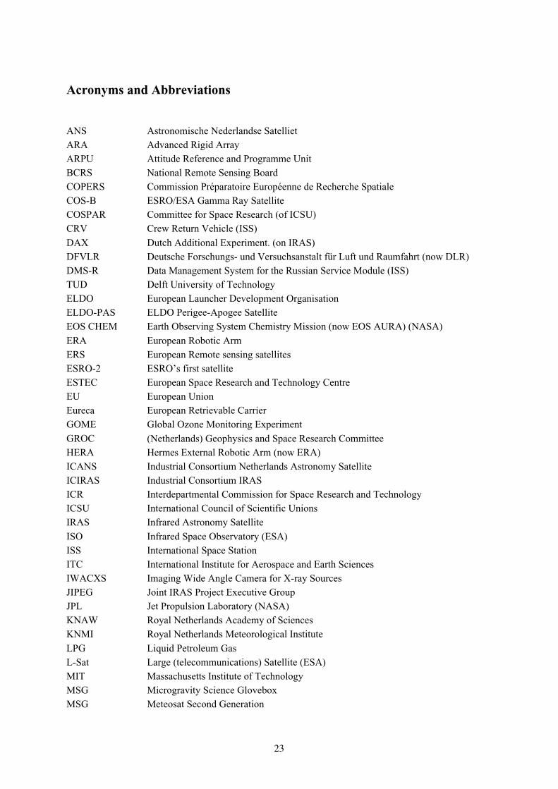
Acronyms and Abbreviations
ANS Astronomische Nederlandse Satelliet
ARA Advanced Rigid Array
ARPU Attitude Reference and Programme Unit
BCRS National Remote Sensing Board
COPERS Commission Préparatoire Européenne de Recherche Spatiale
COS-B ESRO/ESA Gamma Ray Satellite
COSPAR Committee for Space Research (of ICSU)
CRV Crew Return Vehicle (ISS)
DAX Dutch Additional Experiment. (on IRAS)
DFVLR Deutsche Forschungs- und Versuchsanstalt für Luft und Raumfahrt (now DLR)
DMS-R Data Management System for the Russian Service Module (ISS)
TUD Delft University of Technology
ELDO European Launcher Development Organisation
ELDO-PAS ELDO Perigee-Apogee Satellite
EOS CHEM Earth Observing System Chemistry Mission (now EOS AURA) (NASA)
ERA European Robotic Arm
ERS European Remote sensing satellites
ESRO-2 ESRO’s first satellite
ESTEC European Space Research and Technology Centre
EU European Union
Eureca European Retrievable Carrier
GOME Global Ozone Monitoring Experiment
GROC (Netherlands) Geophysics and Space Research Committee
HERA Hermes External Robotic Arm (now ERA)
ICANS Industrial Consortium Netherlands Astronomy Satellite
ICIRAS Industrial Consortium IRAS
ICR Interdepartmental Commission for Space Research and Technology
ICSU International Council of Scientific Unions
IRAS Infrared Astronomy Satellite
ISO Infrared Space Observatory (ESA)
ISS International Space Station
ITC International Institute for Aerospace and Earth Sciences
IWACXS Imaging Wide Angle Camera for X-ray Sources
JIPEG Joint IRAS Project Executive Group
JPL Jet Propulsion Laboratory (NASA)
KNAW Royal Netherlands Academy of Sciences
KNMI Royal Netherlands Meteorological Institute
LPG Liquid Petroleum Gas
L-Sat Large (telecommunications) Satellite (ESA)
MIT Massachusetts Institute of Technology
MSG Microgravity Science Glovebox
MSG Meteosat Second Generation

24
NETSAT Netherlands Satellite
NISO Netherlands Industrial Space Organisation
NIV Netherlands Agency for Aircraft Development
NIVR Netherlands Agency for Aerospace Programmes
NLR National Aerospace Laboratory
NRT NIVR Space Technology programme
NWO Netherlands Organisation for Scientific Research
OMI Ozone Monitoring Instrument
PHARUS Phased Array Universal Synthetic aperture radar
PTI Philips Telecommunications Industry
PTT Post, Telegraph and Telecommunications
RARA Retractable and Retrievable Array
RAWB (Netherlands) Science Policy Council
SAX Satellite per Astronomia in raggi-X (now BeppoSAX)
SERC Science and Engineering Research Council (UK)
SRON Space Research Organisation of the Netherlands
TERS Tropical Earth Resources Satellite
TIXTE Timing and Imaging X-ray Transient Explorer
TNO Netherlands Organisation for Applied Scientific Research
TPD TNO Physical Laboratory
TUD Delft University of Technology
XMM X-ray Multi-Mirror Observatory (now XMM-Newton) (ESA)
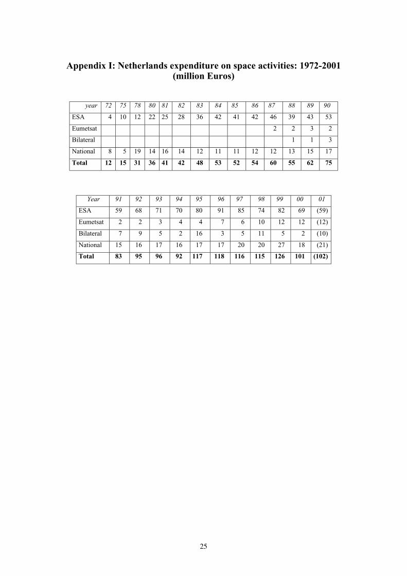
25
Appendix I: Netherlands expenditure on space activities: 1972-2001(million Euros)
year 72 75 78 80 81 82 83 84 85 86 87 88 89 90
ESA 4 10 12 22 25 28 36 42 41 42 46 39 43 53
Eumetsat 2 2 3 2
Bilateral 1 1 3
National 8 5 19 14 16 14 12 11 11 12 12 13 15 17
Total 12 15 31 36 41 42 48 53 52 54 60 55 62 75
Year 91 92 93 94 95 96 97 98 99 00 01
ESA 59 68 71 70 80 91 85 74 82 69 (59)
Eumetsat 2 2 3 4 4 7 6 10 12 12 (12)
Bilateral 7 9 5 2 16 3 5 11 5 2 (10)
National 15 16 17 16 17 17 20 20 27 18 (21)
Total 83 95 96 92 117 118 116 115 126 101 (102)

26
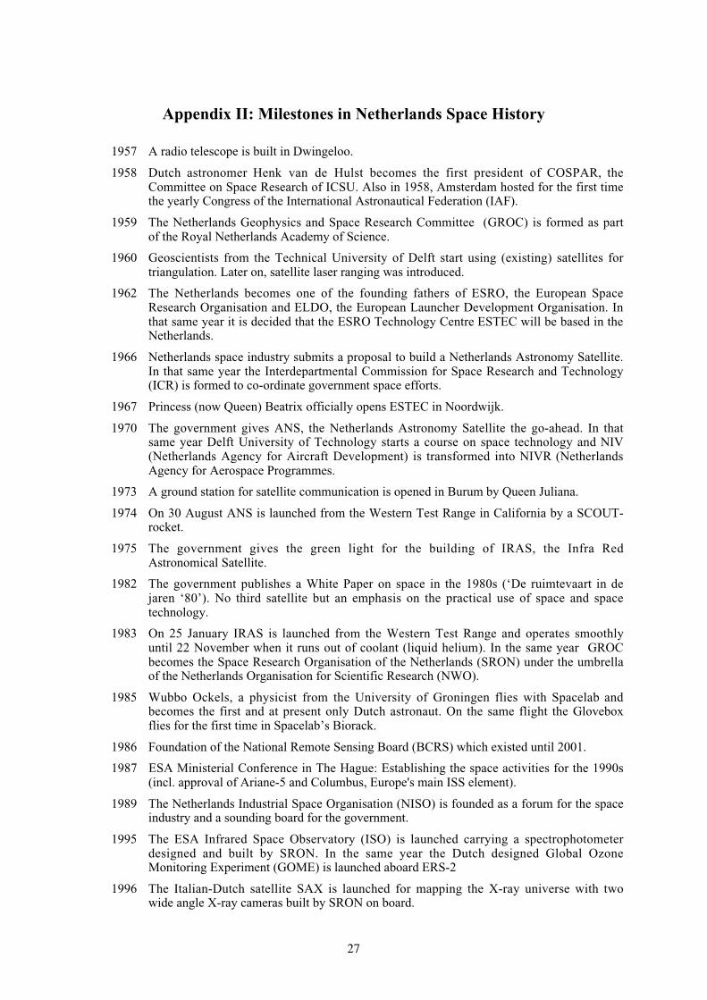
27
Appendix II: Milestones in Netherlands Space History
1957 A radio telescope is built in Dwingeloo.
1958 Dutch astronomer Henk van de Hulst becomes the first president of COSPAR, theCommittee on Space Research of ICSU. Also in 1958, Amsterdam hosted for the first timethe yearly Congress of the International Astronautical Federation (IAF).
1959 The Netherlands Geophysics and Space Research Committee (GROC) is formed as partof the Royal Netherlands Academy of Science.
1960 Geoscientists from the Technical University of Delft start using (existing) satellites fortriangulation. Later on, satellite laser ranging was introduced.
1962 The Netherlands becomes one of the founding fathers of ESRO, the European SpaceResearch Organisation and ELDO, the European Launcher Development Organisation. Inthat same year it is decided that the ESRO Technology Centre ESTEC will be based in theNetherlands.
1966 Netherlands space industry submits a proposal to build a Netherlands Astronomy Satellite.In that same year the Interdepartmental Commission for Space Research and Technology(ICR) is formed to co-ordinate government space efforts.
1967 Princess (now Queen) Beatrix officially opens ESTEC in Noordwijk.
1970 The government gives ANS, the Netherlands Astronomy Satellite the go-ahead. In thatsame year Delft University of Technology starts a course on space technology and NIV(Netherlands Agency for Aircraft Development) is transformed into NIVR (NetherlandsAgency for Aerospace Programmes.
1973 A ground station for satellite communication is opened in Burum by Queen Juliana.
1974 On 30 August ANS is launched from the Western Test Range in California by a SCOUT-rocket.
1975 The government gives the green light for the building of IRAS, the Infra RedAstronomical Satellite.
1982 The government publishes a White Paper on space in the 1980s (‘De ruimtevaart in dejaren ‘80’). No third satellite but an emphasis on the practical use of space and spacetechnology.
1983 On 25 January IRAS is launched from the Western Test Range and operates smoothlyuntil 22 November when it runs out of coolant (liquid helium). In the same year GROCbecomes the Space Research Organisation of the Netherlands (SRON) under the umbrellaof the Netherlands Organisation for Scientific Research (NWO).
1985 Wubbo Ockels, a physicist from the University of Groningen flies with Spacelab andbecomes the first and at present only Dutch astronaut. On the same flight the Gloveboxflies for the first time in Spacelab’s Biorack.
1986 Foundation of the National Remote Sensing Board (BCRS) which existed until 2001.
1987 ESA Ministerial Conference in The Hague: Establishing the space activities for the 1990s(incl. approval of Ariane-5 and Columbus, Europe's main ISS element).
1989 The Netherlands Industrial Space Organisation (NISO) is founded as a forum for the spaceindustry and a sounding board for the government.
1995 The ESA Infrared Space Observatory (ISO) is launched carrying a spectrophotometerdesigned and built by SRON. In the same year the Dutch designed Global OzoneMonitoring Experiment (GOME) is launched aboard ERS-2
1996 The Italian-Dutch satellite SAX is launched for mapping the X-ray universe with twowide angle X-ray cameras built by SRON on board.

28
1999 NASA's advanced X-ray research satellite Chandra and ESA’s X-ray Multi-Mirrorsatellite Newton are launched with SRON instruments.
2001 Government policy on space is evaluated and its goals are re-established.


![A Royal 'Haagse Klok' - Antique Horology · [02V_Charles2] [02V_Coronation] HUYGENS‟ AUTHORITIES (Back to TOC) Readers not familiar with Christiaan Huygens and the early pendulum-era](https://img.pdfslide.us/doc/110x75/5ec79d60c2bd727c0b32cb4e/a-royal-haagse-klok-antique-02vcharles2-02vcoronation-huygensa-authorities.jpg)