Embed Size (px)
Citation preview
106
Chapter 5.
Mapping genealogies – an observer epistemology – astronomy, modernity and the spatial revolution.
The modern world-view has been so lodged upon naturalist notions of experience that people are very reluctant to question their belief in the stability and reality of their visual world. …. The technologies of vision are complex and have been developed with great difficulty over hundreds of years. They encompass not only the material technologies of the lens, telescope, theodolite, microscope and myriad other apparatuses that have emerged in conjunction with the technologies of vision, but also the social ‘technologies’ by which we come to know and order the world visually, the ways it is inscribed and made ‘obvious’ and stable to us. These technologies include the difficult and hard-won practices of perspectival drawing, mapping and picturing technologies that now seem so natural and normal. 1 John Pickles, 2004. A History of Spaces – Cartographic reason, mapping and the geo-coded world.
In his text Opticae Thesaurus, the eleventh century A.D. Islamic
mathematician Abu Ali Al-hazan Ibn Alhazan, using the camera obscura as
an analogue, was able to demonstrate how an image formed on the eye. He
thought of light as a stream of particles, travelling at great speed, reflecting
off an object and entering the eye to create vision. What he also noticed was
that segments of crystal balls could be used to magnify small objects.
In this chaper I discuss the emergence of a cartographic language in early
Modern Europe in which the science of physical optics dominated European
vision. This took place through the concept of the cone of light rays
emanating from the object and entering the eye. It was to become the
foundation of perspective. Nature became the subject of visual interpretation
through human-centred observation. Described as perspectivalism, this was
the organizing principle for visual interpretation. This view redefined space. It
was a way of seeing that influenced the direction of both art and science.
Lise Bek comments on this change of focus:
1 Pickles, The History of Spaces, p. 81.
107
[s]ight was consequently no longer regarded as a fallacious tool for man’s orientation on the world of senses, but was privileged to function as the exact scientific instrument for measuring the geometric scheme not only of the immediate surroundings, but of the whole universe. The diminution of size, blurring of form, and fading of colours with the augmenting distance were no longer considered distortions due to the weakness of sight. They were classified, instead, as accidental features of the visible world that man would be able to compensate for intellectually through comparison and judgement. 2
The tradition of rational thought and scientific observation and analysis of the
natural world grew out of the desire to represent ‘reality’ through empirical
research. When Galileo finally invented his optik tube or telescope, and
mapped an as yet unseen part of the night sky, the understanding of light,
space and time underwent a seminal shift. The mapping of cosmic space
was determined by new evidence about the structure of the universe
revealed through the telescope. The night sky was mapped as a virtual
reality, extending the capacity of the naked eye and turning it in to a virtual
eye.
The New World revival of Classical knowledge enabled the observing subject
to reshape thinking about both celestial and terrestrial space. In European
modernity traditional mapping privileged a distanced and objective form of
seeing predicated on mastery and control. Cosgrove describes the classical
cartographic tendencies within the Renaissance humanist project, revived in
Latin Europe co-incidentally at the same time that Iberian mariners were
extending ideas about space to encompass the new world. Cosgrove
observes that:
‘[a]ccurate’ cartography was figured as a rationalist European science, rooted in pre-Socratic Greek astronomy and Alexandrian and Roman imperial administration, and synthesized by first-century Alexandrian scholars, most specifically Claudius Ptolemy … Thenceforth, with progressive technical and graphic accuracy, the shapes and surfaces of the earth’s continents and oceans and, at more detailed scales, its regions and resources, have been brought within the orbit of a cartographic science which systematically ridded itself of its early and disabling associations with religious belief and with imaginative art. 3
2 Lise Bek, ‘Creating Reality by Sight – A Contribution to the History of Man’s Visual
Relation to his Surroundings’, in Olafur Eliasson - Surroundings Surrounded, p.68. 3 Cosgrove, Mappings, p. 8.
108
My interest lies in the way in which space was shaped through technologies
surrounding the development of the telescope. This extended the view into
the night sky. It changed the possibilities for the role of the observer. In the
context of my own work, I revisit these developments. Every shift in
technology has required us to rethink our ideas about what is meant by
reality. The mapping impulse was particularly evident in northern European
art at this time. It was a response to the desire to understand reality through
the prism of science and the scientific method. What emerged were various
innovative mapping processes and optical technologies. Together with the
dissemination of knowledge through the printed image and word, space
continued to mutate and expand, reshaping ideas about reality that continue
to the present.
The emergence of a cartographic language.
At the commencement of the sixteenth century Albrecht Dürer, the German
artist and mathematician, produced an etching titled Melancholia, 1514. (See
fig. 61). It was charged with symbolic references. The winged goddess,
symbolizing certain earthly phenomena, is pictured as if caught between
mysticism and science, between the past, the present and the future. What is
captured here is the disorientation that is engendered with the premonition of
a revolutionary change in thinking. It is interesting to read the contemporary
observations of the mathematician Szpiro suggesting that in our own time,
[t]he investigations begun by Albrecht Dürer (have seen) a renaissance where computer scientists started dealing with the representation of three-dimensional objects on two-dimensional screens. They had to deal with the problems of hidden lines and – once again – of perspective. 4
In many different cultures for thousands of years, astronomy had been
shaped by a theologically-based physics which had produced few visualizing
concepts. Astronomy has its basis in maths and geometry, and in natural
philosophy; the search for the underlying causes and structures in nature. A
rekindled interest in Classical paradigms, and a focus on rational scientific
inquiry, unfolded with the European Renaissance in the sixteenth century. A
cartographic language developed and celestial mapping appeared in
4 George Szpiro, Kepler’s Conjecture, (New Jersey, Canada: Wiley: Canada, 2003), p. 39.
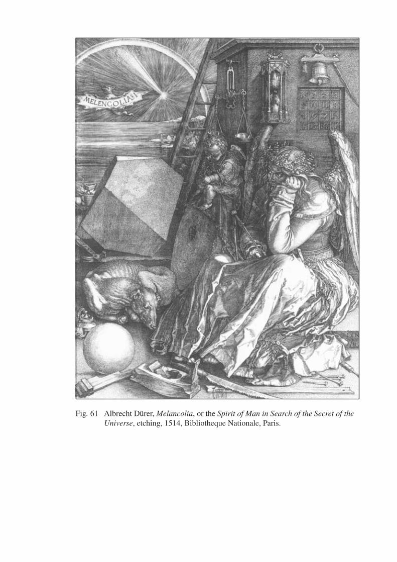
Fig. 61 Albrecht Dürer, Melancolia, or the Spirit of Man in Search of the Secret of the Universe, etching, 1514, Bibliotheque Nationale, Paris.
109
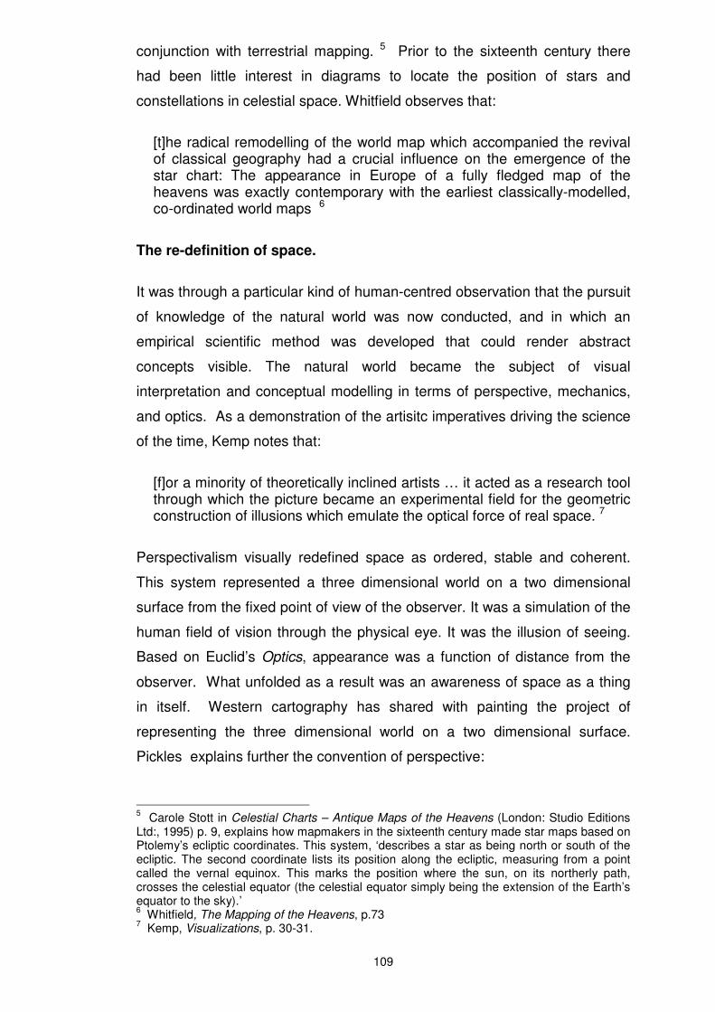
conjunction with terrestrial mapping. 5 Prior to the sixteenth century there
had been little interest in diagrams to locate the position of stars and
constellations in celestial space. Whitfield observes that:
[t]he radical remodelling of the world map which accompanied the revival of classical geography had a crucial influence on the emergence of the star chart: The appearance in Europe of a fully fledged map of the heavens was exactly contemporary with the earliest classically-modelled, co-ordinated world maps 6
The re-definition of space.
It was through a particular kind of human-centred observation that the pursuit
of knowledge of the natural world was now conducted, and in which an
empirical scientific method was developed that could render abstract
concepts visible. The natural world became the subject of visual
interpretation and conceptual modelling in terms of perspective, mechanics,
and optics. As a demonstration of the artisitc imperatives driving the science
of the time, Kemp notes that:
[f]or a minority of theoretically inclined artists … it acted as a research tool through which the picture became an experimental field for the geometric construction of illusions which emulate the optical force of real space. 7
Perspectivalism visually redefined space as ordered, stable and coherent.
This system represented a three dimensional world on a two dimensional
surface from the fixed point of view of the observer. It was a simulation of the
human field of vision through the physical eye. It was the illusion of seeing.
Based on Euclid’s Optics, appearance was a function of distance from the
observer. What unfolded as a result was an awareness of space as a thing
in itself. Western cartography has shared with painting the project of
representing the three dimensional world on a two dimensional surface.
Pickles explains further the convention of perspective:
5 Carole Stott in Celestial Charts – Antique Maps of the Heavens (London: Studio Editions
Ltd:, 1995) p. 9, explains how mapmakers in the sixteenth century made star maps based on Ptolemy’s ecliptic coordinates. This system, ‘describes a star as being north or south of the ecliptic. The second coordinate lists its position along the ecliptic, measuring from a point called the vernal equinox. This marks the position where the sun, on its northerly path, crosses the celestial equator (the celestial equator simply being the extension of the Earth’s equator to the sky).’ 6 Whitfield, The Mapping of the Heavens, p.73
7 Kemp, Visualizations, p. 30-31.
110
[it] centres everything on the eye of the beholder. It is like a beam from a lighthouse – only instead of light travelling outward, appearances travel in. The conventions called those appearances reality. Perspective converges on to the eye as to the vanishing point of infinity. The visible world is arranged for the spectator as the universe was once thought to be arranged for God. 8
The Scientific method – reality and the senses.
The development of scientific method involved the redefinition of space as a
mathematical visual system. As a philosophical inquiry it enabled careful
observation and thorough sifting of fact from fiction. This rejected theories
that could not demonstrate ‘reality’ through empirical research. This assumed
the fallibility of the observer. It also encouraged a growing belief in the fact
that the world consisted of a collection of material, physical objects. A fact is
a verifiable assertion about a thing. Promoting this view the English
philosopher, Sir Francis Bacon, suggested that although we receive
information through the senses, they are, like the mind, extremely unreliable.
It was through the application of disciplined observation, through
experimentation and looking at the facts and the causes, that things were
rendered ‘true’ and coherent. Rather than an idealized reality, the tradition of
Materialism assumed that the world itself was reality, and it was through
disciplined observation that this reality was to be fully revealed. O.B.Hardison
explains:
[a]s Bacon remarks in The Advancement of Learning (1606), “The mind of man is far from the nature of a clear and equal glass, wherein the beams of things should reflect according to their true incidence: nay, it is rather like an enchanted glass, full of superstition and imposture, if it be not delivered and reduced.” 9
Ironically, Bacon’s use of the metaphor of the glass, reflecting and refracting
the mind of man, presupposes the role of optics as a form of ‘truth’
verification in the developing scientific and artistic view of the world. The
development of lenses and telescopes as tools for observing and instruments
for ‘long seeing’, changed irrevocably the way that cosmological space was
comprehended. Through this virtual means, vision was extended deep into
the night sky, well beyond immediate physical experience. This revealed a
8 Pickles, (quoting Berger), in The History of Spaces, p. 85.
9 O.B. Hardison Jr., Disappearing Through The Skylight – Culture and Technology in the
Twentieth Century, (New York: Penguin Books, 1989), p. 18.
111
three dimensional celestial space replete with stars. Wertheim observes, ‘If
…. perspectival imagery trained Western minds to see with a ‘virtual eye’,
the telescope extended our virtual gaze beyond the wildest imaginings of the
Renaissance painters.’ 10
It was thought at the time however that the ‘naked’ eye was more believable
because it allowed things to be observed by more immediate modes of
human perception. Aristotle and Plato formed differing views on the veracity
of the world of the senses. Schechner describes the basis of this debate in
terms of the structure of the cosmos:
Plato argued that there were two worlds – the world of forms and the material world. A form, he said, was an external, perfect, pre-existing idea – a sort of blueprint – that was imperfectly replicated in the physical world, because matter had limitations and was transitory ….. In Timaeus, Plato offered an extended account of a cosmos designed according to mathematical principles. For him an external, divine source had been required to establish cosmic order from a pre-existing chaos … Whereas Plato distrusted the world of the senses, Aristotle, an experienced biologist and natural historian, took sensory experience as the starting point of his philosophy … contended(ing) that the forms of objects did not have prior or higher existence than matter.… (In) Aristotle’s cosmology … Everything below the moon was governed by terrestrial physics. Everything above the moon was governed by celestial mechanics. 11
Arguments about the ‘reality’ value of the ‘virtual’ (the telescopic view), and
‘actual’ (the naked eye view), were questioned. It was thought that in the
absence of proof through immediate sense experience, one could only make
assumptions about what was seen through the telescope, or any other form
of mediated vision. As I have mentioned in the context of my own work, these
are still being debated today as we negotiate new technologies for
observation and image capture that reshape concepts of space and our place
within it.
Lucia Nuti describes how these debates affected mapping and the content of
painting:
[m]apping places by means of drawing faithful portraits of the world as seen provides a record of visual choices, cultures and spatialities. … The desire to overcome the limits and subjectivity of sense knowledge
10
Wertheim, The Pearly Gates of Cyberspace, p. 144. 11
Schechner in Beyond Earth – Mapping The Universe, Ed. David de Vorkin, p. 17,18,19.
112
developed in different directions from the Renaissance to the nineteenth century: on the one hand it determined a general move towards the expulsion of pictorial language from every kind of map; on the other it fuelled the search for an image capable of expressing totality within the field of vision, the panoramic, all-embracing view of the divine eye. 12
Is what we see then a pre-ordained ‘divine-eye’ image of reality embedded in
our memories? Or is it a sense impression, which becomes a more complex
reality through memory? Today it is increasingly suggested that the virtual
spaces generated by technology are in fact a part of our physical, material
conditions. Regarded this way any construction of space is a conception of
our reality. The mapping of space can be considered therefore, a version of
reality.
Physical forces and the motions of the heavens.
Bacon had observed that we perceive physical things, and we perceive their
motions. Aristotle’s model of the universe was finite, with a motionless earth
at its centre, all things moving relative to it. This view was disrupted radically
by the Polish naked eye astronomer Nicolaus Copernicus. In the fifteenth
century, by studying the motion of the planets, he established that they rotate
around the sun, and not the earth. He proposed that the motion of the sky
was caused by the rotation of the earth as it spins around its axis. In the
context of ideas about perspective and the role of the observer already
circulating at the time, Schlain suggests that Copernicus asked himself a
question which allowed him to picture a sun-centred universe. He describes
how Copernicus posed the question:
[h]ow would the orbits of the planets appear if viewed from the vantage of the sun instead of the earth? …. Copernicus, stepping outside the existing model of the solar system and looking back on it from an imaginary outside perspectivist point of view, was able to rearrange the planets and the sun in an entirely new way. 13
For the lay person, the understanding of the relationship between ‘back here’
and ‘out there’ often raises confusing questions about the size and motion of
the solar system. In 2005, a project to de-mystify these phenomena was
created by a science graduate and former astronomy student turned artist,
12
Luci Nuti, ‘Mapping Places: Chorography and Vision in the Renaissance’, in Cosgrove in Mappings, p. 108. 13
Schlain, Art and Physics, p. 59.
113
Christopher Lansell, and Ed Redman a designer and photographer. They
created the St.Kilda Solar System Project, making spheres to represent the
nine planets (if one includes Pluto), at relative scales according to their actual
size. The sun around which they all travel was made a billion times smaller
than it actually is. It was painted gold to stand out in its position opposite the
lighthouse on the foreshore. The planets were strung along the beach in
accordance with the billion to one scale, and displayed over two weekends
with informed minders to answer questions. By walking the length of the
foreshore the viewer encountered the different planet models. These were
placed at the distances they actually are from each other, and from the sun,
Viewers were able to have a physical experience and sense of the Solar
System. The painted model of the Earth was only 1.28 centimetres across
and was a mere speck on the foreshore, just as earth is a tiny speck in the
vastness of space. It was the only planet shown with its moon. This was to
indicate that this is as far as man has travelled in space, emphasizing the
vulnerability and fragility of our planet. 14
While constructing a new star survey in the sixteenth century, Tycho Brahe,
the highly skilled Danish astronomer, suggested measuring the motions of
the heavens to try and establish the heliocentric proposition. He had
observed phenomena in the night sky that caused him to question the belief
in the immutable Aristotelian universe of static celestial objects. In 1572 a
bright new star appeared which he calculated to be farther away than the
moon. To the superstitious it seemed prophetic. This intensely shining light,
which later dissipated, was a super-nova, an exploding star. Later in 1577 his
thoughts were confirmed when he observed a comet moving amongst the
planets. (This I refer to in the Introduction in the context of the recent
McNaught Comet seen in the southern sky in January 2007).
Johannes Kepler, the seventeenth century German astronomer and
mathematician inherited Brahe’s uniquely detailed observations. He had
extraordinary powers of visualization which enabled him to make connections
between the new visual forms in perspectivalism, and a new astronomical
vision. He was able to imagine and integrate an overall vision of the world
into a scientific framework through the application of empirically derived laws
14
‘The planets line up …,’ in The Age (3 December 2005),. p. 3.

114
of mechanics. Kepler documented his findings in his Astronomia Nova in
1609. By the beginning of the seventeenth century he had devised the
fundamental laws of planetary motion seen in his famous geometrical model
of the solar system, the Cosmic Bowl, 1596. (See fig. 62). Whitfield explains:
[h]e discovered…. that the ratios of the planetary orbits conformed to a series of regular solids: between Saturn and Jupiter the cube, between Jupiter and Mars the tetrahedron, between Mars and Earth the dodecahedron, between Earth and Venus the icosahedron, and between Venus and Mercury the octahedron. These are the five regular solids of classical geometry; there are no others. This intriguing model does indeed approximate to the truth, but [interestingly], it transpires to be an isolated relationship, unrelated to any laws of science. 15
Kepler established that there were physical forces emanating from the sun
that propel the planets in their orbits, and he proposed that the planets’
paths were elliptical and not circular as the Greeks had thought. Marc
Lachieze -Rey and Jean-Pierre Luminet explain further:
[Kepler], considered, (the sun), to be not only the origin of daylight but also the cause of the earth’s motion. He attributed to it a “motivic force,” an abstract entity which causes the planets to move. 16
The growing awareness of this ‘motivic force,’ this gravitational pull on the
matter of the universe, has meant that today our understanding of space and
our place in the universe has been exponentially extended. I attempt to give
a sense of this ‘motivic force’ through the use of time lapse star trail images
in my work. The launching of spacecraft, probes, telescopes and satellites
into orbits in outer space, is a technical challenge that would not have been
possible without an understanding of gravitational forces. The astronaut Andy
Thomas describes here the experience of being launched into space:
[y]ou’re strapped to 2,500 tonnes of high explosive, basically, and it’s extraordinary to feel that huge explosion beneath you as the rockets ignite. You feel the thrust as you’re driven up into the sky and the vehicle vibrates and shudders as it lurches up. As you climb into space, you see the sky slowly fade from blue to purple to black. As you get higher and higher and faster and faster, you can feel the shockwaves forming around the vehicle and a red glow out the aft end. When the engines shut down 8 and a half minutes after lift-off, everything just floats up and you find yourself in zero gravity. .. I saw ice crystals that were shed from our fuel tank floating along
15
Whitfield, The Mapping of the Heavens, p. 69. 16
M. Lachieze-Rey, J.P.Luminet, Celestial Treasury, (England: Cambridge University Press, 2001), p. 34, 35.

Fig. 62 Johannes Kepler, The Cosmic Bowl, 1596, engraving, Bibliotheque Nationale, Paris.
115
with us against the blackness of space. They were glinting in the sunlight…Seeing the Earth from the vantage point of space is such a privilege and gives you a new appreciation for the planet that terrestrial-bound people don’t have. 17
Wertheim suggests that Kepler paved the way for astro-physics three
centuries before the NASA Apollo missions explored the moon, when he
imagined a trip to the moon in his book Somnium, (the dream). This work
contributed to the shift of astronomy away from a medieval world picture of
the heavens. He pictured the Moon as the physical space of matter.
Wertheim suggests that:
[e]schewing all hints of medievalism, (Kepler’s), moon is a solid material orb like the earth. On it there are mountains and caves, oceans and rivers, plants grow, animals are born and they die. With this moon we are definitively in the realm of nature. 18
The virtually naked eye and the motivic force.
The term camera obscura, is thought to have been coined by Kepler. He
used this optical device, (which pre-empted both the telescope and later
developments of the camera), as a model to accurately describe the effect of
lenses on light. The camera obscura, often aided with lenses and mirrors,
was used by Kepler and other astronomers to avoid looking directly into the
sun while making solar observations or for seeking knowledge of the light it
propagated. It is thought that a number of artists and architects used it as a
device to record images with meticulous veracity. The camera obscura
became a philosophical metaphor, both scientifically and culturally, for the
pursuit of truth. Crary suggests that:
from the late 1500’s to the end of the 1700’s, the structural and optical principles of the camera obscura coalesced into a dominant paradigm through which was described the status and possibilities of an observer… During the seventeenth and eighteenth century the camera obscura was without question the most widely used model for explaining human vision, and for representing the relation of a perceiver and the position of a knowing subject to an external world… it stood as model in both rationalist and empiricist thought, of how observation leads to truthful inferences about the world 19
17
Anne Lim quoting Andy Thomas in The Weekend Australian Magazine, (September 23-24, 2006), p. 14. 18
Wertheim, The Pearly Gates of Cyberspace, p.142. 19
Crary, Techniques of the Observer, p.27, 28.
116
Kepler was interested in the ways in which the camera obscura might be
analogous to human vision and a tool for observation. Although he never
actually made a telescope, he outlined in Dioptric, (dioptrics, being the part of
optics dealing with refraction), his experimentation with two convex lenses of
unequal focal length to magnify a distant image. Studying the eye, he
described it as an optical mechanism with a focusing lens, and a retina on
which images formed. He separated the eye as a viewing mechanism from
the thing observed, or the world seen from the world pictured, and in so doing
as Svetlana Alpers describes:
[h]is strategy was to separate the physical problem of the formation of retinal images (the world seen) from the psychological problems of perception and sensation… He stands aside and speaks of the prior world picturing itself in light and color on the eye. The function of the mechanism of seeing is defined as making a representation: representation in the dual sense that it is an artifice – in the very making - and that it resolves the rays of light into a picture … visual perception is itself an act of representation in Kepler’s analysis. 20
Experimenting with telescopes, the seventeenth century Dutch physicist and
astronomer Constantijn Huygens maintained this speculative tradition.
Conducting optical and mathematical experiments he developed and
improved lenses and discovered as Watson relates:
that two plano-convex lenses (a field lens and an eye lens), both with their flat surfaces towards the eye, will, if the ratio of their focal lengths and the separation between them are made to specific values, produce a dramatic improvement in performance. Not only is the field of view much improved, but so also is the quality of the image. 21
Huygens was able to observe the planet Saturn and its surrounding rings,
and he located its largest moon, Titan. 22 (I have made reference to this in my
work Bipolar 2. Also see appendix 7). The invention of magnifying lenses
20
Svetlana Alpers, The Art of Describing – Dutch Art in the Seventeenth Century, (Chicago: University of Chicago Press:1984), p. 34,35,36 21
Ibid., p. 98. 22
The twenty first century space craft Cassini, and its probe Huygens, have been investigating Saturn. This is a joint project of NASA, ESA (European Space Agency) and ASI (Agenzia Spatziale Italiana). The investigation is named for Huygens and another seventeenth century Italian astronomer Cassini, who also observed Saturn and is noted for his work surveying and mapping France. Some of the images collected have been incorporated into my digital prints.
117
however, in terms of spatial perception, raised for the observer new issues
relating to space: that of scale and relative size. Alpers makes the point that:
[a]n immediate and devastating result of the possibility of bringing to men’s eyes the minutest of living things (the organism viewed in the microscopic lens), or the farthest and largest (the heavenly bodies viewed through the telescopic lens), was the calling into question of any fixed sense of scale and proportion…. To many it seemed a devastating dislocation of the previously understood measure of the world, or in short, of man as its measure. 23
The sixteenth and seventeenth centuries were periods of remarkable
innovation in both astronomy and in painting. This situated the observer in an
ever-expanding space at both macro and micro scales. The Italian scientist
and mathematician Galileo Galilei focused the ideas of his time with the
telescope. Working with Flemish innovations in spectacle making he
developed this unique magnifying instrument, a refracting telescope, by
deducing that the magnification is the ratio of the focal lengths of the two
lenses. In this way the small concave lens renders a normal eye artificially
long-sighted, perfecting the image. It became an instrument for research into
astronomy and navigation. It became political, with the realization, through
evidence based observation, that the geocentric Ptolemaic system could no
longer be countenanced. 24 The possibility of an infinite space made real
through the lens of the telescope shifted spatial thinking. Burgin quotes
Michel Foucault who observes, ‘starting with Galileo and the seventeenth
century, extension was substituted for localization.’ 25
As Wertheim suggests:
just as today we are beginning to get a sense of the potential vastness of cyberspace, so also Europeans of the seventeenth century were just beginning to get a sense of the potential vastness of the new space they were discovering at the end of their optick tubes. 26
Through this virtual eye Galileo was able to view the physical, material nature
of the moon and stars as never before. Jacob Bronowski relates from
Galileo’s account, ‘(I have seen) stars in myriads, which have never been
seen before, and which surpass the old, previously known stars in number
23
Alpers, The Art of Describing, p. 18. 24
For further reading on this subject see Dava Sobel, Galileo’s Daughter, London: Fourth Estate, 1999. 25
Burgin, In/Different Spaces, p. 41. 26
Wertheim, The Pearly Gates of Cyberspace, p. 144.
118
more than ten times.’ 27 Today it is the view of deep space from NASA’s
Hubble Space Telescope that is extending our vision into the universe
beyond the Milky Way Galaxy. For the first time we have a view of several
hundred previously undetected galaxies beyond our own. It is a ‘needle-eye’
view of the observable limits of the universe, some of the galaxies being four
billion times fainter than the faintest object visible to the naked eye. (This
view I have referenced in my work Deep Field).
On the September 2, 2006, I read a newspaper report of the sighting of a
new supernova in the sky which reminded me of Tycho Brahe, and the night
in 1573 when he observed with the naked eye a bright new star, another
supernova. The newspaper article related that on February 18, 2006, radio
telescopes detected an unimaginably powerful burst of gamma rays which
lasted about forty minutes rather than the usual few thousandths of a second.
This was the brief and intense glow of the aftermath of a supernova, 440
million light years away in a star forming galaxy in the constellation of Aries.
This image, pictured in the newspaper, of the remnant of a supernova
explosion taken from the Hubble Space Telescope, is similar to SN1987A
(see fig. 63), and was originally detected in the invisible areas of the
electromagnetic spectrum. It has been processed through computerized
cameras attached to telescopes to reveal the information in visible light.
The reporter recounts:
[a]stronomers realized that it was an unusual event because it was 25 times closer and 100 times longer than typical. … The exceptionally long burst in the form of a jet of high energy x-rays, pierced through the doomed star from its core and sent out a warning within minutes that a supernova was imminent. As the gamma rays faded away the star exploded. Three telescopes on board NASA’s Swift satellite captured the whole experience. The star’s explosive power is equivalent … to giving off in half an hour as much energy as our sun radiates in about a billion years.28
At first blush the image seen by means of the telescope is imbued with a
luminescent beauty, enhanced and revealed through photographic processes
27
Jacob Bronowski, The Ascent of Man, ( London: British Broadcasting Corporation, 1976), p. 204. 28
Roger Highfield, ‘No theory needed – this really was a big bang,’ in The Age, (2 September 2006), p. 17.
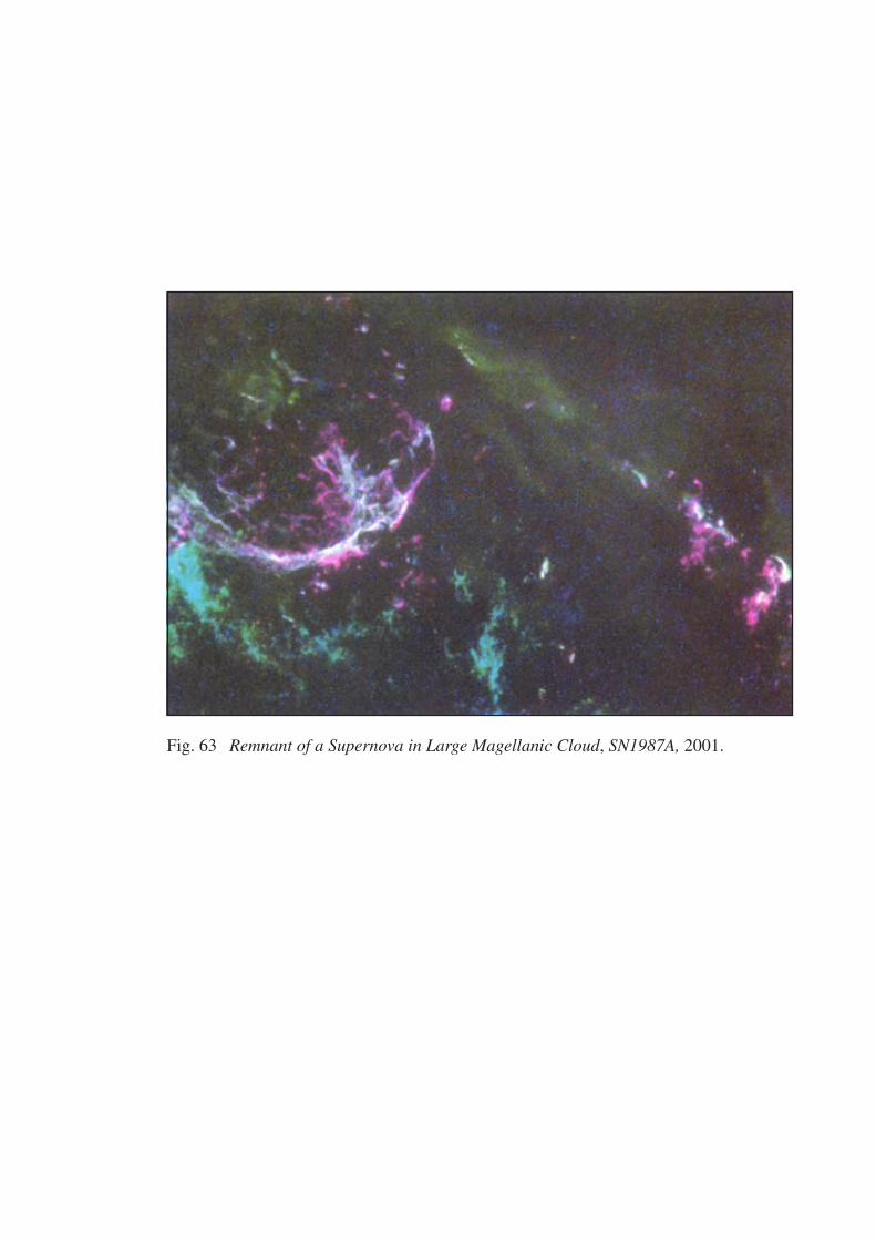
Fig. 63 Remnant of a Supernova in Large Magellanic Cloud, SN1987A, 2001.
119
that are aligned with the aesthetic. When we press for knowledge of its
origins however, other things come into play that transform our sense
experience. The artistic folds into the scientific and the social. This is the
intention of my work. I hope to open up a dialectic between data and the
senses, nature and culture, the real and the virtual, the observer and
observed which metaphorically situate us in time and space, and an ‘other’
reality.
In a limited way in the seventeenth century there was a reciprocity between
the astronomer and the artist. This was the result of a desire to understand,
in terms of light and shadow, the painterly qualities in the topography of the
moon. Bronowski recounts Galileo’s description, ‘full of vast protuberances,
deep chasms and sinuosities.,’ 29 He made paintings of his observations like
his image of Six Phases of the Moon, 1616. (See fig. 64). Kemp observes,
‘an essential ingredient was his ability to articulate his acts of scrutiny and
graphic record through a sophisticated understanding of mobile light on
bodies with uneven surfaces.’ 30 What was of particular interest was what
was known as ‘secondary light.’ For Galileo, this light represented a
confirmation of the Copernican world system. Eileen Reeves explains that
this concept was:
long used by artists and students of optics to describe the faint illumination that occurs when a bright light, falling on a certain kind of surface, is reflected to and scattered over the second surface. Galileo used the term to argue that the dark and opaque earth, when struck by the sun’s rays, was capable of sending that light back out into space and at certain times in the lunar cycle, onto the dim face of the moon itself. 31
Observing the moons of Jupiter, William Day explains, ‘Galileo [also]…
recognized that objects moving relative to a spinning earth meant that objects
moved relative to each other, regardless of any other movement that they
might have.’ 32 From his telescopic observations Galileo was able to
demonstrate the theory of a Sun-centred universe which he published in
1610 in the then politically controversial Siderius Nuncius, (the Starry
29
Bronowski, The Ascent of Man, p. 204. 30
Kemp, Visualizations, p. 41. 31
Eileen Reeves, Painting the Heavens – Art and Science in the Age of Galileo, (New Jersey: Princeton University Press, 1997), p. 8. 32
William Day, ‘Motion’, in Olafur Eliasson - Surroundings Surrounded, p. 152.
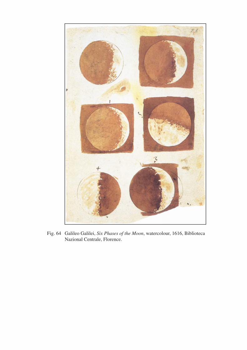
Fig. 64 Galileo Galilei, Six Phases of the Moon, watercolour, 1616, Biblioteca Nazional Centrale, Florence.
120
Messenger). The wider significance of Galileo’s discovery of the moons
around Jupiter is recounted by Whitfield:
[h]ere was a system of celestial master and satellite exactly mirroring the supposedly unique relationship of the sun and its planets. Clearly these were multiple centers of motion in the solar system, and therefore laws of motion which were valid throughout the universe: this discovery now undermined man’s former view of the uniqueness and centrality of the earth. 33
Considering the artists’ pre-occupation with perspective and light as both a
scientific and an enlightening phenomena, a number of artists became
interested in telescopes and astronomy and what they could reveal. There is
known to have been a practice among Tuscan painters at the time for
painting the telescopic moon. Reeves relates that:
[i]n 1611…Lodovico Cigoli and his fellow painter Domenico Cresti (“ïl Passignano”) divided their time between decorating the Pauline Chapel of Santa Maria Maggiore, (in Florence), and actually mastering the telescope, occasionally treating the church itself as an informal observatory from which they viewed first the clock at St. Peter’s, then the people and buildings of nearby Frascati and Tivoli, then the moon, the sun, and finally, the Medici stars or moons of Jupiter. 34
Galileo, although well informed as a draftsman and an expert on perspective,
relied on a number of artists to assist with his astronomical activities. One of
these artists was Giovanni Battista Agucchi, a theorist of Baroque art, who
used a telescope to observe Jupiter’s moons. Later it is said that he had an
image of Jupiter’s moons painted on the wall of his house. 35 Astronomers
often included artistic metaphors in their writings. The Jesuit astronomer
Christopher Scheiner, in 1612, published his observations of sunspots under
the pseudonym of the ancient painter Apelles.
In 1991, while an artist in residence at the American Academy in Rome,
Dorothea Rockburne visited a seventeenth century mannerist villa in which
there was a frescoed astronomy room, a sky chart covering the walls, (which
sloped in a curve), and the ceiling. It depicted the Galiean-Copernican
concept of the sun’s relation to the earth by charting the supposed elliptical
33
Whitfield, Mapping The Heavens, p. 70. 34
Eileen Reeves, Painting The Heavens , p. 5. 35
Ibid.
121
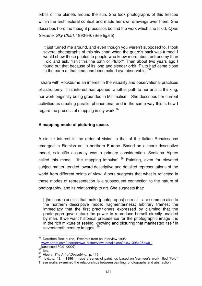
orbits of the planets around the sun. She took photographs of this frescoe
within the architectural context and made her own drawings over them. She
describes here the thought processes behind the work which she titled, Open
Sesame: Sky Chart. 1990-99. (See fig.65):
It just turned me around, and even though you weren’t supposed to, I took several photographs of this sky chart when the guard’s back was turned. I would show these photos to people who knew more about astronomy than I did and ask, “Isn’t this the path of Pluto?” Then about two years ago I found out that because of its long and slender orbit, Pluto had come close to the earth at that time, and been naked eye observable. 36
I share with Rockburne an interest in the visuality and observational practices
of astronomy. This interest has opened another path to her artisitc thinking,
her work originally being grounded in Minimalism. She describes her current
activities as creating parallel phenomena, and in the same way this is how I
regard the process of mapping in my work. 37
A mapping mode of picturing space.
A similar interest in the order of vision to that of the Italian Renaissance
emerged in Flemish art in northern Europe. Based on a more descriptive
model, scientific accuracy was a primary consideration. Svetlana Alpers
called this model ‘the mapping impulse’ 38 Painting, even for elevated
subject matter, tended toward descriptive and detailed representations of the
world from different points of view. Alpers suggests that what is reflected in
these modes of representation is a subsequent connection to the nature of
photography, and its relationship to art. She suggests that:
[t]he characteristics that make (photographs) so real – are common also to the northern descriptive mode: fragmentariness; arbitrary frames; the immediacy that the first practitioners expressed by claiming that the photograph gave nature the power to reproduce herself directly unaided by man. If we want historical precedence for the photographic image it is in the rich mixture of seeing, knowing and picturing that manifested itself in seventeenth century images. 39
36
Dorothea Rockburne, Excerpts from an Interview 1995: www.artnet.com/usernet/awc_historyview_details.asp?aid=139842&awc_i [accessed 30/01/2007] 37
Ibid. 38
Alpers, The Art of Describing, p. 119. 39
Ibid., p. 43. In1996 I made a series of paintings based on Vermeer’s work titled ‘Fold.’ These works examined the relationships between painting, photography and abstraction.
Fig. 65 Dorothea Rockburne, Open Sesame Sky Chart, pencil on photograph, 1990-1999, courtesy of the artist.
122
Artists were experimenting with different points of view made possible
through lenses and mirrors, basic elements of the modern camera. A convex
mirror is situated in Jan Van Eyck’s 1434 painting Arnolfini Wedding. In an
innovative way it projects back to the viewer the image of the couple in the
room from the rear. The contemporary British artist David Hockney has
written about Renaissance painting and the scientific and visual evidence for
ways of seeing. He observed that, ‘[l]enses and mirrors were still rare then,
and artists would have been fascinated by the strange effects they produced.’
40 The fascination with the metaphor of the mirror was more than an
experiment with strange effects. It represented a theory of knowledge which
situated the mind as a mirror of reality. Those things existing outside the
mind were represented by a concept or a work of art regarded as true and
accurate. Cosgrove relates that the French moral philosopher Charles de
Bovelles (1479-1567), refers to the human individual as a ‘mirror who stands
outside and opposite the rest of creation in order to observe and reflect the
world.’ 41 Subsequently the development of the telescope opened up the
night sky through the study of optics, magnification and the refraction and
reflection of light using specialized glass and mirrors.
Over time the metaphor of the mirror has shifted becoming a signifier for
developing modes of being and perception. The ‘space’ of the mirror behaves
not only as a scientific instrument, but it is a means of reflecting the way in
which the viewer constructs space. In this way I have used mirrors in my own
work. The mirror also returns the gaze, and all that is implied in this
reflection in the space of the present. In our current era, the impact of
computerization and reproduction technologies has continued a dialectic
about reality and the copy which is causing us to revisit and rethink the
nature of representation. The Australian artist Stephen Haley, working with
both painting and computer generated images, develops the idea of the
mirror as an echo. Through ‘mirroring’, Thomas says that the purpose of
Haley’s work is:
40
David Hockney, Secret Knowledge – Rediscovering the Lost Techniques of the Old Masters (London:Thames and Hudson, 2001), p. 72. Jan Van Eyck’s Arnolfini Wedding can be seen on p. 82, 83. I have referenced in earlier work fragments of this painting, and reflective elements and optical and topographical devices from other Flemish and Spanish paintings of this period. 41
Cosgrove, Apollo’s Eye, p. 118.
123
to assist us in understanding how we experience and construct meaning through language, form and technology, [observing that] Haley’s mirroring is a representation that accepts the reality of a copy that, like the echo, has its own identity and originality.42
My own work is created with reproductions of images through both analogue
and digital manipulation. In this way I engage with the process of mapping.
The found images from which I construct my work, rather like echoes, create
a map, (which is a form of visible reality), revealing an invisible reality, (the
space being mapped). In this way, removed from the idea of the singular
veracity of the original, I re-create the night sky, a space almost completely
incomprehensible to the senses. Filtered through viewing and interpretive
devices that stand in for first hand experience, it is not possible to understand
this space other than as a simulation that then recreates its own reality.
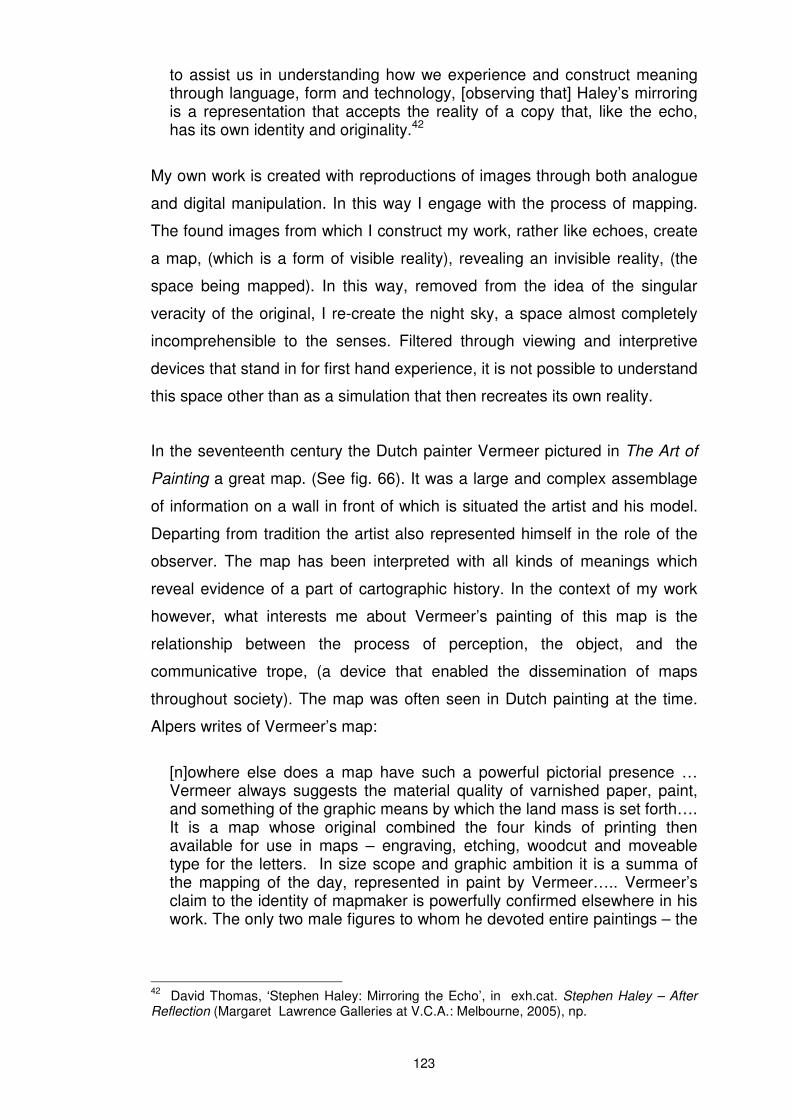
In the seventeenth century the Dutch painter Vermeer pictured in The Art of
Painting a great map. (See fig. 66). It was a large and complex assemblage
of information on a wall in front of which is situated the artist and his model.
Departing from tradition the artist also represented himself in the role of the
observer. The map has been interpreted with all kinds of meanings which
reveal evidence of a part of cartographic history. In the context of my work
however, what interests me about Vermeer’s painting of this map is the
relationship between the process of perception, the object, and the
communicative trope, (a device that enabled the dissemination of maps
throughout society). The map was often seen in Dutch painting at the time.
Alpers writes of Vermeer’s map:
[n]owhere else does a map have such a powerful pictorial presence … Vermeer always suggests the material quality of varnished paper, paint, and something of the graphic means by which the land mass is set forth…. It is a map whose original combined the four kinds of printing then available for use in maps – engraving, etching, woodcut and moveable type for the letters. In size scope and graphic ambition it is a summa of the mapping of the day, represented in paint by Vermeer….. Vermeer’s claim to the identity of mapmaker is powerfully confirmed elsewhere in his work. The only two male figures to whom he devoted entire paintings – the
42
David Thomas, ‘Stephen Haley: Mirroring the Echo’, in exh.cat. Stephen Haley – After Reflection (Margaret Lawrence Galleries at V.C.A.: Melbourne, 2005), np.
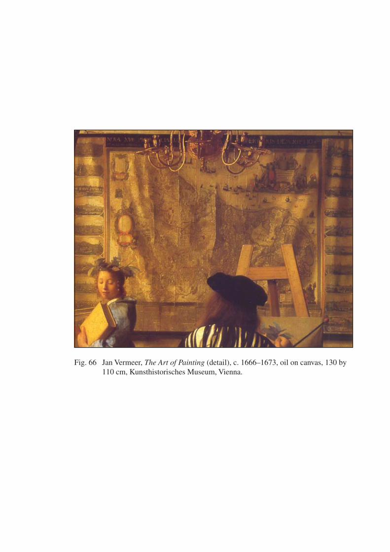
Fig. 66 Jan Vermeer, The Art of Painting (detail), c. 1666–1673, oil on canvas, 130 by 110 cm, Kunsthistorisches Museum, Vienna.
124
Astronomer… and the Geographer… were also by profession makers of maps and they encompassed the heavens and the earth between them. 43
In a virtual sense Vermeer has layered in his map image various kinds of
reproductive printing technologies of the day, just as I have done in my digital
works on paper. Vermeer seemed to use the picture as an experimental field,
just as I have used the mapping process. His generalized patches of paint,
on close view seeming quite abstract and lacking in detail, are carefully
placed to become optical illusions through the necessity of the viewer to do
the perceptual work. 44 Unlike Vermeer I am not able to be visibly present as
an observer in the spaces about which I make work. However, my pre-
occupation is with the process of observation.
Expanding space – reproductions and projections.
In the changing climate of thought in early modern Europe, the model of
perspective enabled, Burgin suggests:
something of the premodern worldview [to pass] into the Copernican universe – a universe that is no longer geocentric but is nevertheless homocentric and egocentric. A basic principle of Euclidean geometry is that space extends infinitely in three dimensions. The effect of monocular perspective however, is to maintain the idea that this space nevertheless does have a centre – the observer. By degrees the sovereign gaze is passed from God to man. With the “emplacement “(as pre-ordained by God) of the Medieval world now dissolved, this ocular subject of perspective, and of mercantile capitalism, is free to pursue its entrepreneurial ambitions wherever trade winds blow. 45
To discover meant to map. Mapping and European spatiality was stretched to
new limits by oceanic navigation, (through the discoveries of Columbus,
Magellan, and later Cook). The cartographer Andrea Corsali had observed ‘a
43
Alpers, The Art of Describing, p. 121,122. 44
The optical preoccupations of the day also appear in his Allegory of Faith, in which he paints the pure and symbolic form of a suspended crystal sphere reflecting patches of light
from an unseen window. In 1997 I made a series of paintings using the reflective image on
this sphere to work with ideas about revelation, concealment and photography. 45
Victor Burgin, In/Different Spaces, p. 41,42. Burgin makes the analogy between Aristotelian cosmological physics, where the place of the body between the centre and periphery of the universe, is determined by its relationship to the four elements, (earth, air, fire or water). He likens this to a humanist derived political philosophy where the ‘inherent ‘ qualities in the human being determine his or her ‘natural’ place in the space of a social hierarchy.
125
marvellous order of starres’ 46 in the Southern Hemisphere in 1679, and had
drawn the Southern Cross constellation, the circle representing sixty degrees
latitude south and centred on the South Celestial Pole. It was a time of new
global imaginings, influenced by an understanding of the conceptual logic
embedded in the theories of optics and vision. Cosgrove suggests that:
[g]iven the increased mobility of reproduced images promoted by moveable type, print-making and small scale oil painting on canvas, the imaginative and intellectual possibilities opened up by Ptolemaic mapping was considerable. It entered and enhanced a culture in which visual images of terrestrial, architectural, and natural spaces at a variety of scales circulated widely. 47
During the Renaissance key centres of printing and map production were
located in southern Germany, Antwerp and Venice. In these centres was to
be found a connection between painting and global mapping. This was
evidenced through the practice of world landscape painting which Cosgrove
suggests ‘appear to illustrate a substantial segment of the globe’s surface, a
vast panorama with multiple viewpoints…’ 48 An increasingly secularized
view but also still a Gods-eye view, in which planetary physics had a major
influence. Whitfield explains:
[there] was [an] empirical revolution in astronomy, and its effect was to produce an outpouring of research and of popular publications which described and portrayed the skies. The emergence and proliferation of published star maps after 1600 would have been unthinkable without the impetus provided by the central problem of planetary physics. Planetary positions were published in tables known as ephemerides, which the observer, professional or amateur, astronomer or astrologer, could then relate to his star chart. 49
The earth was now understood to be a spherical rather than a flat domain.
Interest intensified in projecting the earth’s surface upon a sphere. This
enabled the representation and wider awareness of the scope of the earth, of
the world encompassed, and the idea of the celestial sphere enclosing the
terrestrial sphere. In 1507, the cosmographer Martin Waldseemuller
designed a terrestrial globe by first drawing a map into twelve gored sections,
46
From Australia’s Great Libraries, p. 10. 47
Cosgrove, Apollo’s Eye, 106. See also http://bell.lib.umn.edu/map/WALD/GLOBE/mainw6.html [accessed 20.07.04]. 48
Ibid., p. 128. 49
Whitfield, The Mapping of the Heavens, p. 70,71

126
(like two dimensional sections of an orange). Recently rediscovered, this
Woodcut of Martin Waldseemuller’s Terrestrial Globe Gores, (see fig. 67), is
described here by Cosgrove: ‘each gore depicts 30 degrees of longitude on
both sides of a meridian stretching from pole to pole.’ 50 As deconstructed
fragments of these earlier spatial models these gore shapes have been used
in the construction of some of my paintings and digital works on paper.
Waldseemuller’s gore sheets were then transferred to woodblocks and
finally onto a globe. He incorporated in his work Cosmographiae introductio a
descriptive book, a map of the world and a terrestrial globe. Cosgrove notes
Waldseemuller’s description:
[t]he Cosmographia proposed to write an introduction to the cosmography which we have illustrated in solid form (a globe) as well as on a flat surface (a map). It is quite reduced in solid form, of course, because of the limited space, but more detailed on the flat surface. 51
Celestial and terrestrial global pairs were matched, at first using the ecliptic
co-ordinate system and then the equatorial system. Elaborate constellation
figures had earlier been developed through copper plate etching and the rich
artistry of the hand colourist. This culminated in the Venetian globe maker
Vincenzo Coronelli’s work that reflected the lavish detail of late Baroque art.
There were however both technical and political problems in projecting an
inexact representation of the world map upon a sphere. Inevitably Europe’s
spatio-temporal centrality continued to dominate. These models became
displays of power embedded in the idea of scholarship connected to wealth,
exemplified in Holbein’s painting in 1533 The Ambassadors. 52 The most well
known projection is the 1569 Mercator Projection, named for the Flemish
sixteenth century map and globe maker Gerard Mercator. Although the
Mercator Projection and other models are still used, they remain contentious
in mapping practice to this day. Buckminster Fuller’s and Shoji Sadao’s
50
Cosgrove, Mappings, p. 49. 51
Ibid., p. 79. 52
The Ambassadors can be seen in Hockney, Sacred Knowledge, p. 56. Holbein’s painting led me in to a small mapping project which explored the poetics of the globe. In 2004 I purchased from the Oxford Natural History Museum in the U.K., a paper model for hand assembling of the terrestrial globe in Holbein’s painting. I traced the template and made small globes on which were aerial photographs of the upper atmosphere, and the effects of light, taken from a jet on my way back from Europe. I have also referenced the anamorphic skull in this painting in previous work.
Fig. 67 Martin Waldseemuller’s Terrestrial Globe Gores, 1507, woodcut.

127
Dymaxion Airocean World Map 1954, and the Peter’s Projection (the world
up side down, a Pacific focus), are contemporary critiques of this practice. 53
I have referenced the Aitoff Projection in my digital prints Bipolar 1,2 and 3.
(See appendix 1).
The manifestations of this Eurocentric spatio-temporal centrality were
expressed in the immersive spaces of the map gallery. Today we might
describe these as an immersive space of virtual reality similar to
contemporary representations in art and architecture. Within the light and
space of late Renaissance and Baroque architectonics representations of the
heavens on ceilings absorbed the observer into immersive illusory spaces.
Cosgrove describes the map gallery, (commissioned for the Ufizzi Palace by
Cosimo de Medici in 1562), which consisted of fifty seven Ptolemaic maps,
and was created by the cosmographer Egnazio Danti, as follows:
[b]elow the maps were paintings of the plants and animals of each region, and above them were portraits of their rulers. From the ceiling which was decorated with zodiacal signs, a great terrestrial globe could be lowered by windlass. “so that when fixed, all the pictures and the maps on the cabinet will be reflected therein, each part being thus readily found on the sphere.” Cosimo could stand at the very centre of space surveying heavenly and earthly globes. 54
The dissemination of ideas, and the development of maps, (not least of which
were celestial atlases, globes and star charts), arose out of experimentation
with observational and mapping practices. They burgeoned between 1500
and 1800 as a result of the development of new and innovative printing and
publishing processes. Through original research astronomy was being
advanced through detailed charts and atlases. Astronomers like Piccolomini
in 1540, Bayer, (Uranometria 1603), Helvelius, (Uranographia 1687), Bode,
(Uranographia 1801, whose maps went to the limit of naked eye visibility and
beyond), and Flamsteeed’s (Atlas Coelestis), 1729, (produced
53
These projections can be viewed at www.progonos.com 20/07/04 www.bfi.org/map.htm 20/07/04 www.petersworldmap.org/index1.html 20/07/04. 54
Cosgrove, Apollo’s Eye, p. 124.
128
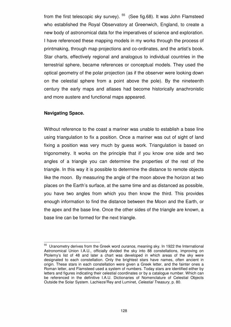
from the first telescopic sky survey). 55 (See fig.68). It was John Flamsteed
who established the Royal Observatory at Greenwich, England, to create a
new body of astronomical data for the imperatives of science and exploration.
I have referenced these mapping models in my works through the process of
printmaking, through map projections and co-ordinates, and the artist’s book.
Star charts, effectively regional and analogous to individual countries in the
terrestrial sphere, became references or conceptual models. They used the
optical geometry of the polar projection (as if the observer were looking down
on the celestial sphere from a point above the pole). By the nineteenth
century the early maps and atlases had become historically anachronistic
and more austere and functional maps appeared.
Navigating Space.
Without reference to the coast a mariner was unable to establish a base line
using triangulation to fix a position. Once a mariner was out of sight of land
fixing a position was very much by guess work. Triangulation is based on
trigonometry. It works on the principle that if you know one side and two
angles of a triangle you can determine the properties of the rest of the
triangle. In this way it is possible to determine the distance to remote objects
like the moon. By measuring the angle of the moon above the horizon at two
places on the Earth’s surface, at the same time and as distanced as possible,
you have two angles from which you then know the third. This provides
enough information to find the distance between the Moon and the Earth, or
the apex and the base line. Once the other sides of the triangle are known, a
base line can be formed for the next triangle.
55
Uranometry derives from the Greek word ouranos, meaning sky. In 1922 the International Astronomical Union I.A.U., officially divided the sky into 88 constellations, improving on Ptolemy’s list of 48 and later a chart was developed in which areas of the sky were designated to each constellation. Only the brightest stars have names, often ancient in origin. These stars in each constellation were given a Greek letter, and the fainter ones a Roman letter, and Flamsteed used a system of numbers. Today stars are identified either by letters and figures indicating their celestial coordinates or by a catalogue number. Which can be referenced in the definitive I.A.U. Dictionaries of Nomenclature of Celestial Objects Outside the Solar System. Lachieze’Rey and Luminet, Celestial Treasury, p. 80.
Fig. 68 John Flamsteed, Atlas Coelestis, 1729, (detail), The British Library.
129
In this way a survey of interconnecting triangles map a space. 56 The
coastline gave a triangle and a base line, (the distance between the two
observation points). Once the coastline was out of sight however, the mariner
had to rely on dead reckoning, using the direction of sail and the distance
travelled, to determine his longitude, (his east-west position, the parallel of
latitude providing the north-south position from the Equator). Experimenting
with this model I have created a tall cylindrical tube on which this
triangulation is marked. Like electronic signals in cyberspace, a network of
these lines flows around the tube. Intended to disrupt the idea of a flat
mapped surface, it suggests rather the continual horizon of curved space.
The search for a more accurate way of determining longitude at sea was an
Enlightenment imperative, born out of a belief in the ability of the rational
mind to order and control space. Central to this was the measuring of time
and the meridian of longitude at Greenwich, the location from which time
variation had to be calculated. (It later became the Universal Prime Meridian).
Together with marine astronomy tables, and a refined marine chronometer
(which had been invented by John Harrison to keep accurate shipboard
time 57), mariners were able to determine their position. Cosgrove reminds
us however that:
all mapping involves sets of choices, omissions, uncertainties and intentions –authorship – at once critical to, yet obscured within, its final product, the map itself. Paul Carter… in his discussion of the ‘coastline’ [notes that] … Not only are all coasts in fact zones rather than lines – the unstable space between high and low water in tidal zones for example – which the cartographer has to ‘fix’ according to criteria which are inevitably arbitrary, but their linearity is mapped by determining a finite set of points which are then joined by a sweep of the cartographer’s hand to create a coastline. That sweep is governed as much by corporeal dexterity as visual acuity and mimetic imperative. 58
56
Today closer celestial distances are measured by the parallax method. As Earth orbits the sun, nearby stars appear to move from side to side against a backdrop of more distant stars. The angle through which any star moves over a period of six months is called its parallax. The star’s distance can then be calculated using the geometry of angles – the larger the parallax the closer the star. For ground based observations the baseline should be the largest available, the diameter of the Earth’s orbit, one measurement of the position of the star made twice, half a year apart. Giles Sparrow, The Universe and How to See It, (London: New Burlington Books: 2001), p. 84. 57
To read more about the establishment of the accurate location of longitude using the marine chronometer see Dava Sobel, Longitude, London: Fourth Estate, 1998. 58
Cosgrove, Mappings, p. 7.
130
In just this vein Captain James Cook’s voyages to the Antipodes from
England in the late seventeen hundreds mapped new territory. The accuracy
of the marine tables was established by observing the Transit of Venus
across the sun from the Southern Pacific.59 Cook was able to test the
accuracy of Harrison’s clock, contributing to the establishment of a universal
coordinate system. In the process Cook determined the existence of terra
australis incognita, the unresolved space in Baroque maps.60
European intellectual imperatives and curiosity drove the urgency to make
available seminal scientific manuscripts in book form, and to circulate this
knowledge. The natural and human world was opened up for analysis
through diagrams and illustrations, maps, globes, planispheres and orreries
(moveable or mechanical cosmological models), and the reproduction of
images from classical antiquity. Once the transmission of knowledge and
skills had been an oral tradition, a function of the art of memory. It was often
secret and arcane knowledge passed on by specialist teachers. Frances
Yates observes, ‘in the ages before printing a trained memory was vitally
important; and the manipulation of images in memory must always to some
extent involve the psyche as a whole.’ 61 The development that occurred in
mapping opened up new realities and visualizations while paradoxically
functioning as an ‘aide-memoire,’ as a mnemonic device.
59
This was one of several international observations of this rare event, intended to help calculate the size of the solar system, and witnessed most recently in our time in 2004. The ‘transit’ technique has also been used with visible - light telescopes to detect extra – solar planets where a planet’s presence is inferred when it passes in front of its star, causing the star to dim or blink, and indirectly the planets mass and size is revealed. Now new planets are being detected at non-visible wavelengths by comparing the light emissions from the parent star and the suspected planet. For further information http://www.universetoday.com/am/publish/first_light_extrasolar.html?2232005 p 2. [accessed 10/05/05]. 60
On Cook’s second voyage in 1775, he was accompanied by the artist William Hodges, who through his work contributed to the veracity of Cook’s written record. His painting (Çascade Cove) Dusky Bay, shows the rugged mountains of the South Island of New Zealand, a darkly Romantic evocative landscape, in which sunlight shines through the intense white light of a water fall creating a coloured spectrum, (a rainbow), that flashes across the painting. Geoff Quilley, the editor of William Hodges 1744-1797 – The Art of Exploration, (National Maritime Museum, Greenwich – Yale University Press: New Haven and London, 2004), includes this work on p.111 of the catalogue. He spoke at my exhibition Which Way Is Up? mounted in 2005 in the United Kingdom with Sarah Winfrey. In his address he refers to this painting in relationship to my work Deep Field, with its coloured spectrum flash and elements of light. He makes an analogy between the two works, where observations about the natural world are made through the exploration of light and colour and developing techniques and technologies in art and science. 61
Frances A, Yates, The Art of Memory (London: Pimlico, 1966), p. 11.
131
In this chapter I have discussed the emergence of a cartographic language in
the European tradition, its relationship to astronomy, and the mapping of the
night sky. The development of perspective was an organizing principle of
visual representation where a human centred observer was placed at the
centre of projection. It was a system that simulated the human field of vision
through the physical eye, and where Nature became the subject of visual
interpretation. Coupled with this was the study of the science of optics and
the development of the telescope. This enabled new imaginings in which
vision was extended into a heliocentric and moving universe. I have noted in
the text various borrowed fragments of spatial concepts and mapping models
used in my work and their relationship to my cartographic turn of mind. These
reference such things as time lapse star trail images and gravitational
movements or forces, gore shapes from deconstructed globes, observing
technologies and the virtual eye of the telescope, the geometry of
triangulation and graticule, and printmaking practices.
Celestial and terrestrial mapping in Early Modern Europe attracted both
scientific and artistic interest. It was linked to an imperialist project that
explored new territory and was grounded in the Enlightenment belief in the
ability of the rational mind to order and control space. The re-definition of
space in this context was governed by an increasingly rigid scientific
determinism in which the nature of reality was re-thought through debates
about the relative value of the senses and the intellect, the mind and the
body. Although these ideas remained influential, at the end of the nineteenth
century, they began to be increasingly challenged.