Embed Size (px)
Citation preview
A9
B970
B970
B970
B970
B970
B915
2
A9
A9
Badan anDroma
T H E Q U E E N ' S F O R E S T
T H E Q U E E N ' S F O R E S T
Creag a'Ghreusaiche
CallartHill
Creag Mheadhonach
An Slugan
Meall a' Bhuachaille
Creagan Gorm
Castle Hill
Torr Dearg
KennapoleHill
Creag a' Chaillich
Craiggowrie
Airgiod-Meall
LochPityoulish
Lochan Dubha' Chadha
An LochanUaine
LochanMor
LochGamhna
Loch Morlich
Loch anEilein
Lochannan Geadas
River Druie
River Luineag
Am B
eana
idh
Allt Druidh
Allt Dubhag
Milton Burn
River
Spe
y
Spey
River
River Spey
810
732
456
729
644
435
711
447687
416
694
385
428
Coylumbridge
Inverdruie
ThePolchar
Doune
Aviemore
Granish
TreeZone
ReindeerCentre
GlenmoreLodge
Aviemore
0 1
0 1
2 3 Kilometres
2 Miles
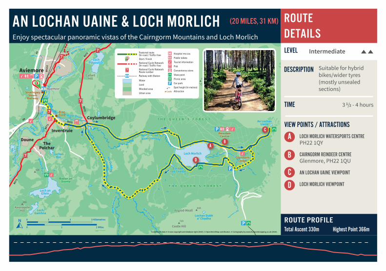
LEVEL Intermediate
ROUTE PROFILETotal Ascent 330m Highest Point 366m
A
C
BA
C
B
VIEW POINTS / ATTRACTIONS
LOCH MORLICH WATERSPORTS CENTRE PH22 1QY
CAIRNGORM REINDEER CENTREGlenmore, PH22 1QU
AN LOCHAN UAINE VIEWPOINT
LOCH MORLICH VIEWPOINT
TIME
DESCRIPTION
AN LOCHAN UAINE & LOCH MORLICH ROUTE DETAILSEnjoy spectacular panoramic vistas of the Cairngorm Mountains and Loch Morlich
3 1/2 - 4 hours
Suitable for hybrid bikes/wider tyres (mostly unsealed sections)
D
D
Contains OS data © Crown copyright and database right (2020). © OpenStreetMap contributors. © Cartography by www.fourpointmapping.co.uk (2020).
(20 MILES, 31 KM)
712
Castle
Featured routeOn-road / Traffic-freeStart / FinishNational Cycle NetworkOn-road / Traffic-freeNational Cycle NetworkRoute numberRailway with StationSpot height (in metres)Attraction
Water
Land
Wooded area
Urban area
Hospital (FK8 2AU)
Public toilets
Tourist information
Pub
Convenience store
Campsite
View point
Picnic area
Car park712
Castle
Featured routeOn-road / Traffic-freeStart / FinishNational Cycle NetworkOn-road / Traffic-freeNational Cycle NetworkRoute numberRailway with StationSpot height (in metres)Attraction
Water
Land
Wooded area
Urban area
Hospital (FK8 2AU)
Public toilets
Tourist information
Pub
Convenience store
Campsite
View point
Picnic area
Car park

AN LOCHAN UAINE & LOCH MORLICHROUTE LEVEL CLASSIFICATIONS
Enjoy spectacular panoramic vistas of the Cairngorm Mountains and Loch Morlich(20 MILES, 31 KM)
FRIENDLY STOPS
ROUTE DESCRIPTIONFollow the picturesque and traffic free Old Logging Way from Aviemore, through the native Scots Pine forest and heather moorlands of Glenmore, to the beautiful viewpoint at An Lochan Uaine (or Green Lochan) in the Ryvoan Pass.
Keep your eyes peeled for red squirrels as you double back on forest tracks around Loch Morlich for stunning views of the Cairngorms and Strathspey, before re-joining the Old Logging Way for a gentle downhill ride back towards Aviemore.
Insert photo Here
Insert photo Here
Introductory Intermediate Challenging
DISTANCETERRAIN
DISTANCETERRAIN
DISTANCETERRAIN
>35 KMHILLY
15-35 KMSOME HILLS
<15 KMFEW TO NO HILLS
THE DISTANCES MAY VARY SLIGHTLY FROM THE CLASSIFICATION DEPENDING ON THE AMOUNT OF HILLS AND THE NATURE OF THE ROUTE
MIKE’S BIKES5A Myrtlefield Shopping Centre, Aviemore, PH22 1SB01479 810478
THE GLENMORE SHOP & PINE MARTEN BARGlenmore, PH22 1QU01479 861253
VIA BOAT OF GARTEN AND NETHY BRIDGE
GLENMORE LODGEGlenmore, PH22 1QZ01479 861256
ROTHIEMURCHUS CENTRE & CAFÉAviemore, PH22 1QH 01479 812345