Embed Size (px)
Citation preview
Ocean DynamicsDOI 10.1007/s10236-015-0808-z
An investigation of ensemble-based assimilation of satellitealtimetry and tide gauge data in storm surge prediction
Paula Etala · Martın Saraceno · Pablo Echevarrıa
Received: 22 January 2014 / Accepted: 5 January 2015© Springer-Verlag Berlin Heidelberg 2015
Abstract Cyclogenesis and long-fetched winds along thesoutheastern coast of South America may lead to floodsin populated areas, as the Buenos Aires Province, withimportant economic and social impacts. A numerical model(SMARA) has already been implemented in the region toforecast storm surges. The propagation time of the surgein such extensive and shallow area allows the detectionof anomalies based on observations from several hoursup to the order of a day prior to the event. Here, weinvestigate the impact and potential benefit of storm surgelevel data assimilation into the SMARA model, with theobjective of improving the forecast. In the experiments,the surface wind stress from an ensemble prediction sys-tem drives a storm surge model ensemble, based on theoperational 2-D depth-averaged SMARA model. A 4-DLocal Ensemble Transform Kalman Filter (4D-LETKF)
Responsible Editor: Kevin Horsburgh
This article is part of the Topical Collection on the 13thInternational Workshop on Wave Hindcasting and Forecasting inBanff, Alberta, Canada October 27 - November 1, 2013
P. Etala (�)Servicio de Hidrografıa Naval, Av. Montes de Oca 2124,C1270ABV, City of Buenos Aires, Argentinae-mail: [email protected]
M. SaracenoCentro de Inv. del Mar y la Atmosfera (CIMA)/UBA/FCEN-CONICET, UMI3351-IFAECI/CNRS-CONICET-UBA, CiudadUniversitaria, Pab.II 2 piso, City of Buenos Aires, (1428),Argentina
P. EchevarrıaServicio Meteorologico Nacional, 25 de mayo 658 4 piso,C1002ABN, City of Buenos Aires, Argentina
initializes the ensemble in a 6-h cycle, assimilating thevery few tide gauge observations available along the north-ern coast and satellite altimeter data. The sparse coverageof the altimeters is a challenge to data assimilation; how-ever, the 4D-LETKF evolving covariance of the ensembleperturbations provides realistic cross-track analysis incre-ments. Improvements on the forecast ensemble mean showthe potential of an effective use of the sparse satellite altime-ter and tidal gauges observations in the data assimilationprototype. Furthermore, the effects of the localization scaleand of the observational errors of coastal altimetry and tidalgauges in the data assimilation approach are assessed.
Keywords Storm surge prediction · Data assimilation ·Ensemble Kalman filter
1 Introduction
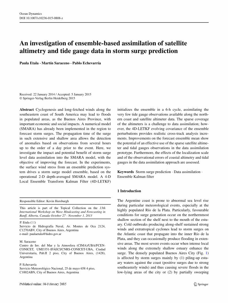
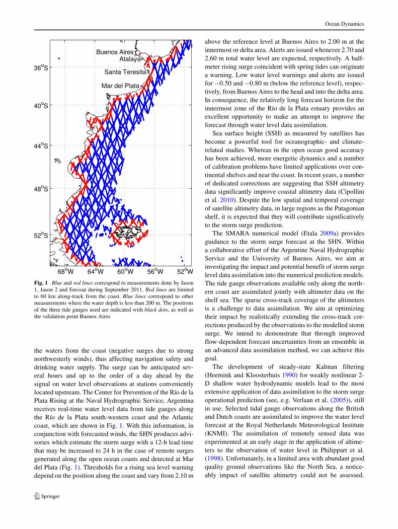
The Argentine coast is prone to abnormal sea level riseduring particular meteorological events, especially at thehighly populated Rıo de la Plata. Particularly, favourableconditions for surge generation occur on the northernmostshallow section of the shelf next to the mouth of the estu-ary. Cold outbreaks producing along-shelf sustained strongwinds and extratropical cyclones lead to storm surges onthe Atlantic coast that propagate into the inner Rıo de laPlata, and they can occasionally produce flooding in exten-sive areas. The most severe events occur when intense localwinds along the extremely shallow estuary enhance thesurge. The densely populated Buenos Aires City (Fig. 1)is affected by storm surges mainly by (1) piling-up estu-ary waters against the coast (positive surges due to strongsoutheasterly winds) and thus causing severe floods in thelow-lying areas of the city or (2) by partially sweeping
Ocean Dynamics
Fig. 1 Blue and red lines correspond to measurements done by Jason1, Jason 2 and Envisat during September 2011. Red lines are limitedto 60 km along-track from the coast. Blue lines correspond to othermeasurements where the water depth is less than 200 m. The positionsof the three tide gauges used are indicated with black dots, as well asthe validation point Buenos Aires
the waters from the coast (negative surges due to strongnorthwesterly winds), thus affecting navigation safety anddrinking water supply. The surge can be anticipated sev-eral hours and up to the order of a day ahead by thesignal on water level observations at stations convenientlylocated upstream. The Center for Prevention of the Rıo de laPlata Rising at the Naval Hydrographic Service, Argentinareceives real-time water level data from tide gauges alongthe Rıo de la Plata south-western coast and the Atlanticcoast, which are shown in Fig. 1. With this information, inconjunction with forecasted winds, the SHN produces advi-sories which estimate the storm surge with a 12-h lead timethat may be increased to 24 h in the case of remote surgesgenerated along the open ocean coasts and detected at Mardel Plata (Fig. 1). Thresholds for a rising sea level warningdepend on the position along the coast and vary from 2.10 m
above the reference level at Buenos Aires to 2.00 m at theinnermost or delta area. Alerts are issued whenever 2.70 and2.60 m total water level are expected, respectively. A half-meter rising surge coincident with spring tides can originatea warning. Low water level warnings and alerts are issuedfor −0.50 and −0.80 m (below the reference level), respec-tively, from Buenos Aires to the head and into the delta area.In consequence, the relatively long forecast horizon for theinnermost zone of the Rıo de la Plata estuary provides anexcellent opportunity to make an attempt to improve theforecast through water level data assimilation.
Sea surface height (SSH) as measured by satellites hasbecome a powerful tool for oceanographic- and climate-related studies. Whereas in the open ocean good accuracyhas been achieved, more energetic dynamics and a numberof calibration problems have limited applications over con-tinental shelves and near the coast. In recent years, a numberof dedicated corrections are suggesting that SSH altimetrydata significantly improve coastal altimetry data (Cipolliniet al. 2010). Despite the low spatial and temporal coverageof satellite altimetry data, in large regions as the Patagonianshelf, it is expected that they will contribute significativelyto the storm surge prediction.
The SMARA numerical model (Etala 2009a) providesguidance to the storm surge forecast at the SHN. Withina collaborative effort of the Argentine Naval HydrographicService and the University of Buenos Aires, we aim atinvestigating the impact and potential benefit of storm surgelevel data assimilation into the numerical prediction models.The tide gauge observations available only along the north-ern coast are assimilated jointly with altimeter data on theshelf sea. The sparse cross-track coverage of the altimetersis a challenge to data assimilation. We aim at optimizingtheir impact by realistically extending the cross-track cor-rections produced by the observations to the modelled stormsurge. We intend to demonstrate that through improvedflow-dependent forecast uncertainties from an ensemble inan advanced data assimilation method, we can achieve thisgoal.
The development of steady-state Kalman filtering(Heemink and Kloosterhuis 1990) for weakly nonlinear 2-D shallow water hydrodynamic models lead to the mostextensive application of data assimilation to the storm surgeoperational prediction (see, e.g. Verlaan et al. (2005)), stillin use. Selected tidal gauge observations along the Britishand Dutch coasts are assimilated to improve the water levelforecast at the Royal Netherlands Meteorological Institute(KNMI). The assimilation of remotely sensed data wasexperimented at an early stage in the application of altime-ters to the observation of water level in Philippart et al.(1998). Unfortunately, in a limited area with abundant goodquality ground observations like the North Sea, a notice-ably impact of satellite altimetry could not be assessed.
Ocean Dynamics
Philippart et al. (1998) applied to the fully nonlinear stormsurge prediction problem, the Reduced Rank SQuare RooT(RRSQRT) Kalman filter (Verlaan and Heemink 1997),which is an efficient approximation to the Extended KalmanFilter (EKF) through a simplification of the error covari-ance calculation. The same approach was implemented byCanizares et al. (1998) in a different 2-D model, also forthe North Sea. Both practical methods were later includedin a common general framework for data assimilation inhydrodynamic models, the COmmon Set of Tools for theAssimilation of Data (COSTA) (van Velzen and Verlaan2007), as well as the Ensemble Kalman Filter (EnKF). Otherapproaches to assimilate data for storm-surge operationalprediction considered adjoint techniques (Li et al. 2013;Lionello et al. 2006) and variational data assimilation (Pengand Xie 2006).
Since Evensen (1994) first proposed the EnKF as analternative to the EKF, where flow-dependent backgrounderrors were based on an ensemble, several approaches tothe model update or analysis step have been introduced andapplied to multiple problems in geophysics. The EnKF algo-rithm is naturally independent from the prediction modelused. An efficient square root EnKF scheme based on thesingular evolutive interpolated Kalman (SEIK) filter wasimplemented by Butler et al. (2012) to the problem of thestorm surge produced by hurricanes. The authors succeededin achieving improved maximum water levels by usinguncertainties from hindcasts of an advanced 2-D storm surgemodel for selected events. Ott et al. (2004) proved the fea-sibility of an entirely local scheme for the EnKF in theso-called Local Ensemble Kalman Filter (LEKF) and Huntet al. (2007) dramatically improved the efficiency of cal-culations in the Local Ensemble Transform Kalman Filter(LETKF). The latter belongs to the SQuare RooT (SQRT)filters type or “deterministic” EnKF, in which an analysisfor the ensemble mean is first produced and then the ensem-ble perturbations expanded through the analysis covariance.To our knowledge, this method has not been applied so farto the storm surge prediction problem and its potential per-formance is explored through the prototype presented in thiswork.
The main goal of this initiative is to investigate the feasi-bility and potential benefit of assimilating observations withstorm surge prediction purposes in a context of a large areaof generation lacking real-time conventional data, given theopportunity provided by newly available satellite observa-tion techniques. Section 2 refers to the observational dataused for both assimilation and validation. In Section 3, webriefly explain the basics of the data assimilation methodand describe the application of the Miyoshi and Yamane(2007) implementation of the 4D-LETKF. The data assim-ilation scheme is mainly focused on a deterministic-type6-h forecast, represented in this case by the ensemble mean.
Section 4 presents the design of 1-month assimilation exper-iments. Results are presented and discussed in Section 5.Finally, conclusions are summarized in Section 6.
2 The storm surge observations
Satellite altimetry data have been downloaded using RadarAltimeter Database System (RADS, http://rads.tudelft.nl).The data base contains validated and verified altimeter dataproducts that are consistent in accuracy, format, correctionand reference system parameters. Much effort has been putin calibrating and validating the raw data, i.e. harmoniza-tion of geophysical corrections, of secondary data and of themeasurements themselves. The validation includes editing,tide experiments, radiometer-model collocation and Rossbyand Kelvin waves propagation analysis (Naeije et al. 2000).Data for all satellite missions available for the periods oftime studied have been included in this study (Fig. 1).
Coastal water level stations are available from the SHNfor the northernmost part of the shelf and in the Rıo de laPlata only. In this study, hourly water level residuals fromthree tide gauges are used in the assimilation: Mar del Plataat the open sea coast, Santa Teresita at the mouth of the estu-ary and Atalaya at the mid-estuary (Fig 1). The last two arealso used for validation of the 6-h forecasts produced in thiswork. Satellite altimetry provides some coverage off-shoreand, occasionally, on the extensive areas lacking coastaldata.
3 The data assimilation method
A basic assumption is that the actual errors-of-the-day liewithin a lower dimension space than the full system. Then,if the ensemble system provides a reasonably good estima-tion of these errors, the dimension of the problem can bereduced locally. The general approach of the EnKF com-bines the flow-dependent background errors provided byan ensemble prediction and the observations to build theanalysis ensemble, including the analysis uncertainty. Theanalysis ensemble so obtained provides the initial state to anew ensemble forecast cycle. Due to the unavoidable pres-ence of model errors and non linearities, short cycles are ingeneral more suitable to the EnKF, and in particular to theLETKF, than a longer assimilation cycle (e.g. Kalnay et al.2007)
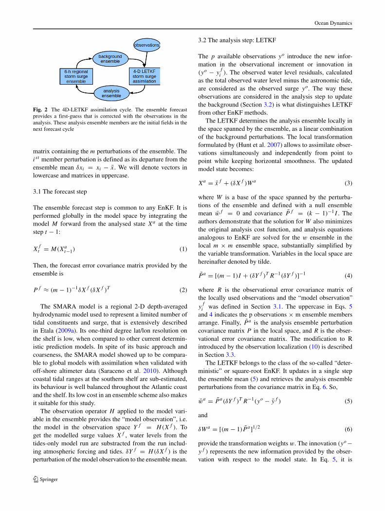
The 4D-LETKF, as originally coded by T. Miyoshi(Miyoshi and Yamane 2007), has been adapted to assimi-late storm surge data into an ad hoc 20-member storm surgemodel ensemble. This 4-D scheme initializes the ensem-ble in a 6-h cycle (Fig. 2). Given an n-dimensional modelstate x and an m-member model ensemble, δX is the m × n
Ocean Dynamics
Fig. 2 The 4D-LETKF assimilation cycle. The ensemble forecastprovides a first-guess that is corrected with the observations in theanalysis. These analysis ensemble members are the initial fields in thenext forecast cycle
matrix containing the m perturbations of the ensemble. Theist member perturbation is defined as its departure from theensemble mean δxi = xi − x. We will denote vectors inlowercase and matrices in uppercase.
3.1 The forecast step
The ensemble forecast step is common to any EnKF. It isperformed globally in the model space by integrating themodel M forward from the analysed state Xa at the timestep t − 1:
Xft = M(Xa
t−1) (1)
Then, the forecast error covariance matrix provided by theensemble is
P f ≈ (m − 1)−1δXf (δXf )T (2)
The SMARA model is a regional 2-D depth-averagedhydrodynamic model used to represent a limited number oftidal constituents and surge, that is extensively describedin Etala (2009a). Its one-third degree lat/lon resolution onthe shelf is low, when compared to other current determin-istic prediction models. In spite of its basic approach andcoarseness, the SMARA model showed up to be compara-ble to global models with assimilation when validated withoff-shore altimeter data (Saraceno et al. 2010). Althoughcoastal tidal ranges at the southern shelf are sub-estimated,its behaviour is well balanced throughout the Atlantic coastand the shelf. Its low cost in an ensemble scheme also makesit suitable for this study.
The observation operator H applied to the model vari-able in the ensemble provides the “model observation”, i.e.the model in the observation space Yf = H(Xf ). Toget the modelled surge values Xf , water levels from thetides-only model run are substracted from the run includ-ing atmospheric forcing and tides. δY f = H(δXf ) is theperturbation of the model observation to the ensemble mean.
3.2 The analysis step: LETKF
The p available observations yo introduce the new infor-mation in the observational increment or innovation in(yo − y
f
i ). The observed water level residuals, calculatedas the total observed water level minus the astronomic tide,are considered as the observed surge yo. The way theseobservations are considered in the analysis step to updatethe background (Section 3.2) is what distinguishes LETKFfrom other EnKF methods.
The LETKF determines the analysis ensemble locally inthe space spanned by the ensemble, as a linear combinationof the background perturbations. The local transformationformulated by (Hunt et al. 2007) allows to assimilate obser-vations simultaneously and independently from point topoint while keeping horizontal smoothness. The updatedmodel state becomes:
Xa = xf + (δXf )Wa (3)
where W is a base of the space spanned by the perturba-tions of the ensemble and defined with a null ensemblemean wf = 0 and covariance P f = (k − 1)−1I . Theauthors demonstrate that the solution for W also minimizesthe original analysis cost function, and analysis equationsanalogous to EnKF are solved for the w ensemble in thelocal m × m ensemble space, substantially simplified bythe variable transformation. Variables in the local space arehereinafter denoted by tilde.
P a = [(m − 1)I + (δY f )T R−1(δY f )]−1 (4)
where R is the observational error covariance matrix ofthe locally used observations and the “model observation”y
f
i was defined in Section 3.1. The uppercase in Eqs. 5and 4 indicates the p observations × m ensemble membersarrange. Finally, P a is the analysis ensemble perturbationcovariance matrix P in the local space, and R is the obser-vational error covariance matrix. The modification to Rintroduced by the observation localization (10) is describedin Section 3.3.
The LETKF belongs to the class of the so-called “deter-ministic” or square-root EnKF. It updates in a single stepthe ensemble mean (5) and retrieves the analysis ensembleperturbations from the covariance matrix in Eq. 6. So,
wa = P a(δY f )T R−1(yo − yf ) (5)
and
δWa = [(m − 1)P a]1/2 (6)
provide the transformation weights w. The innovation (yo−yf ) represents the new information provided by the obser-vation with respect to the model state. In Eq. 5, it is
Ocean Dynamics
expressed in terms of the perturbation from the ensemblemean.
Equations 4 to 6 are those actually solved by the algo-rithm in the local space of the ensemble. The full analysisensemble is then built through (3) back into the globalmodel space. Alternatively, we may choose to update theanalysis mean or the deterministic model in a hybrid-typeapproach by
xa = xf + (δXf )wa (7)
The analysis ensemble perturbations in this scheme areclose to the original background ensemble perturbations, as
δXa = (δXf )(δWa) (8)
from Eqs. 3 and 7.The full analysis ensemble is then built including addi-
tive inflation, which is a tuning parameter for the ensemblespread, as
Xa = xa + (δXa) + AI × (δXk) (9)
where AI is a tuning factor and (δXk) are the perturba-tions of an arbitrary ensemble. It is an usual practice to setany linear combination of the forecast perturbations afterthe spin-up of the assimilation, while additive perturbationsmay be generated by any other method or randomly at theinitiation of the cycles. The particular implementation in thiswork is detailed in Section 4.
3.3 Observation localization
Any corrections introduced by the observations only takeplace in the scale of the ensemble perturbations covarianceand cross-covariance, as will be shown in Section 5. Eitherthe extent of the ensemble perturbation covariances or anarbitrary localization scale may limit the influence of theobservations in space and time in the analysis. Nevertheless,some localization in space and time is required to overrideoccasional spurious background perturbations covariance,not related to the local background uncertainty. Due to thepotentially large scale of the surge phenomena, observa-tions within a wide local patch are selected for the analysisaround a grid point. The so-called “observation localiza-tion” approach is applied, in which the observational erroris exponentially increased with distance to the analysis gridpoint by the function ω in Eq. 10.
ω(dist) = e−dist2/2L2(10)
The weight factor ω is applied to the inverse R matrixin the calculations. In the local analysis of Eqs. 4 to 6, ω
is an attribute of every observation. This “smoothed local-ization” approach lowers the influence of an observation
to half its value at a distance L while decreasing expo-nentially. L is called the “localization scale”. Although ina classical EnKF approach, as discussed in (Miyoshi andYamane 2007), the impact of this scale is closely relatedto the observational errors and smoother than covariancelocalization, in this LETKF scheme, it impacts directlyon the weight of the individual innovation through R inEq. 5.
Asynchronous observations from altimeters and hourlyobservations from tide gauges are disposed at hourly timeslots within a 6-h assimilation window, centered on the anal-ysis time. The innovations calculated on an hourly basispair with evolving forecast error covariances in Eq.5. Alocalization in time ω(t), completely analogous to Eq. 10,limits the observation influence within the assimilation win-dow, where a parameter T plays the role of the localizationscale.
4 Experiments setup
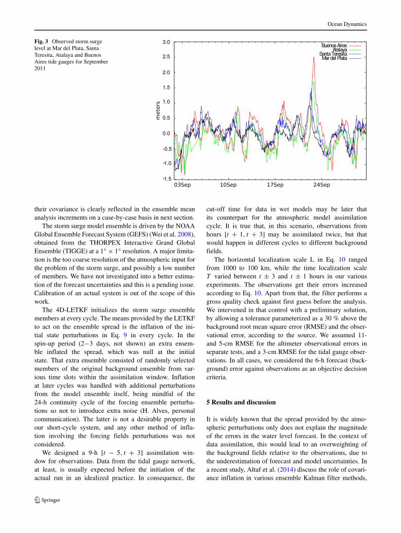
Data assimilation experiments of storm surge observationswere carried out on the Argentine continental shelf forSeptember 2011. The experiments on the current prototypewere aimed at the assessment of the benefit of data assimi-lation on the storm surge short-term prediction. We explorethe role of the basic parameters in the scheme, such as local-ization scales and observational errors, in such an impact.The period of study was chosen due to three moderate tostrong rising surge events that took place on the northernshelf and estuary in that month. Residuals from hourly waterlevel observations at tide gauges in Fig. 1 are plotted inFig. 3. The observation in the City of Buenos Aires, at thehead of the estuary, is also shown for reference, althoughit is not included in this study. It will be shown below thatthe prototype ensemble mean failed to predict accuratelythe peaks, providing a favourable scenario to test a potentialimprovement through the assimilation.
Coastal stations are conveniently located for the fol-lowup of the storm surge into the Rıo de la Plata. On theother hand, the lack of data on the rest of the shelf is onlytempered by the sparse and unevenly distributed altimeterobservations. Typical spatial distributions of data within a9-h assimilation window are seen in Figs. 6 and 8. This iswhy the knowledge of the forecast uncertainties becomesparticularly important for the correct estimation of analy-sis increments. Occasionally, covariance of the surge levelperturbations δxiδxj extends along the coastline. The along-shore storm surge produced by long-fetched southerly windsprovides the most suitable scenario for the data assimila-tion. Alternatively, local southwesterly winds produced byrelatively small size perturbations may only benefit fromlocal data. The horizontal scale of the uncertainties and
Ocean Dynamics
Fig. 3 Observed storm surgelevel at Mar del Plata, SantaTeresita, Atalaya and BuenosAires tide gauges for September2011
their covariance is clearly reflected in the ensemble meananalysis increments on a case-by-case basis in next section.
The storm surge model ensemble is driven by the NOAAGlobal Ensemble Forecast System (GEFS) (Wei et al. 2008),obtained from the THORPEX Interactive Grand GlobalEnsemble (TIGGE) at a 1◦ × 1◦ resolution. A major limita-tion is the too coarse resolution of the atmospheric input forthe problem of the storm surge, and possibly a low numberof members. We have not investigated into a better estima-tion of the forecast uncertainties and this is a pending issue.Calibration of an actual system is out of the scope of thiswork.
The 4D-LETKF initializes the storm surge ensemblemembers at every cycle. The means provided by the LETKFto act on the ensemble spread is the inflation of the ini-tial state perturbations in Eq. 9 in every cycle. In thespin-up period (2−3 days, not shown) an extra ensem-ble inflated the spread, which was null at the initialstate. That extra ensemble consisted of randomly selectedmembers of the original background ensemble from var-ious time slots within the assimilation window. Inflationat later cycles was handled with additional perturbationsfrom the model ensemble itself, being mindful of the24-h continuity cycle of the forcing ensemble perturba-tions so not to introduce extra noise (H. Alves, personalcommunication). The latter is not a desirable property inour short-cycle system, and any other method of infla-tion involving the forcing fields perturbations was notconsidered.
We designed a 9-h [t − 5, t + 3] assimilation win-dow for observations. Data from the tidal gauge network,at least, is usually expected before the initiation of theactual run in an idealized practice. In consequence, the
cut-off time for data in wet models may be later thatits counterpart for the atmospheric model assimilationcycle. It is true that, in this scenario, observations fromhours [t + 1, t + 3] may be assimilated twice, but thatwould happen in different cycles to different backgroundfields.
The horizontal localization scale L in Eq. 10 rangedfrom 1000 to 100 km, while the time localization scaleT varied between t ± 3 and t ± 1 hours in our variousexperiments. The observations get their errors increasedaccording to Eq. 10. Apart from that, the filter performs agross quality check against first guess before the analysis.We intervened in that control with a preliminary solution,by allowing a tolerance parameterized as a 30 % above thebackground root mean square error (RMSE) and the obser-vational error, according to the source. We assumed 11-and 5-cm RMSE for the altimeter observational errors inseparate tests, and a 3-cm RMSE for the tidal gauge obser-vations. In all cases, we considered the 6-h forecast (back-ground) error against observations as an objective decisioncriteria.
5 Results and discussion
It is widely known that the spread provided by the atmo-spheric perturbations only does not explain the magnitudeof the errors in the water level forecast. In the context ofdata assimilation, this would lead to an overweighting ofthe background fields relative to the observations, due tothe underestimation of forecast and model uncertainties. Ina recent study, Altaf et al. (2014) discuss the role of covari-ance inflation in various ensemble Kalman filter methods,
Ocean Dynamics
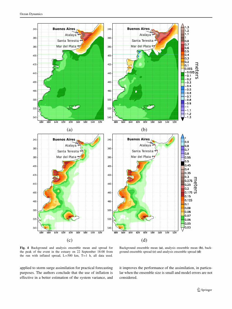
Fig. 4 Background and analysis ensemble mean and spread forthe peak of the event in the estuary on 22 September 18:00 fromthe run with inflated spread, L=500 km, T=1 h, all data used.
Background ensemble mean (a), analysis ensemble mean (b), back-ground ensemble spread (c) and analysis ensemble spread (d)
applied to storm surge assimilation for practical forecastingpurposes. The authors conclude that the use of inflation iseffective in a better estimation of the system variance, and
it improves the performance of the assimilation, in particu-lar when the ensemble size is small and model errors are notconsidered.
Ocean Dynamics
As mentioned in the previous section, the limitation tocapture actual sources of uncertainty has not been com-prehensively addressed in this work. We artificially modi-fied the spread by inflating the initial perturbations of theanalysis ensemble in various tests, so to roughly matchthe RMSE from the hindcast to the 12-h forecast stormsurge level. For the month of our study, the determin-istic SMARA model RMSE in Mar del Plata for thoseranges was in the order of 0.15 m. The analysis and back-ground ensemble mean and spread so obtained at the timeof the peak of the surge in Buenos Aires are presentedin Fig. 4.
The error in the background ensemble mean, i.e. the 6-h forecast after the assimilation evaluates the performance
of the data assimilation scheme. The improved initializa-tion should lead to a measurable benefit in the forecast fromcycle to cycle. In the following plots in this section, wepresent the partial effect of different factors we assessed inthe scheme. Finally, we present the integral impact of thedata assimilation by comparing the same error curves to acontrol run without data assimilation.
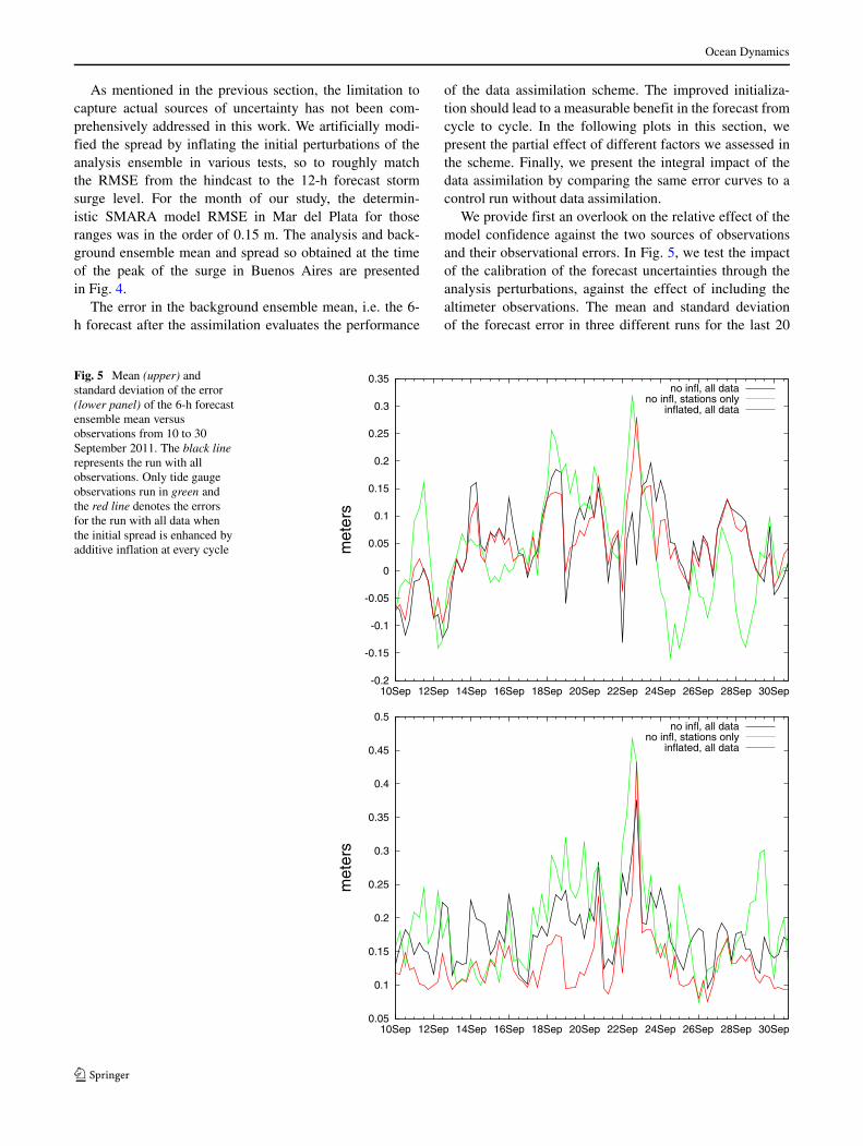
We provide first an overlook on the relative effect of themodel confidence against the two sources of observationsand their observational errors. In Fig. 5, we test the impactof the calibration of the forecast uncertainties through theanalysis perturbations, against the effect of including thealtimeter observations. The mean and standard deviationof the forecast error in three different runs for the last 20
Fig. 5 Mean (upper) andstandard deviation of the error(lower panel) of the 6-h forecastensemble mean versusobservations from 10 to 30September 2011. The black linerepresents the run with allobservations. Only tide gaugeobservations run in green andthe red line denotes the errorsfor the run with all data whenthe initial spread is enhanced byadditive inflation at every cycle
-0.2
-0.15
-0.1
-0.05
0
0.05
0.1
0.15
0.2
0.25
0.3
0.35
10Sep 12Sep 14Sep 16Sep 18Sep 20Sep 22Sep 24Sep 26Sep 28Sep 30Sep
met
ers
no infl, all datano infl, stations only
inflated, all data
0.05
0.1
0.15
0.2
0.25
0.3
0.35
0.4
0.45
0.5
10Sep 12Sep 14Sep 16Sep 18Sep 20Sep 22Sep 24Sep 26Sep 28Sep 30Sep
met
ers
no infl, all datano infl, stations only
inflated, all data
Ocean Dynamics
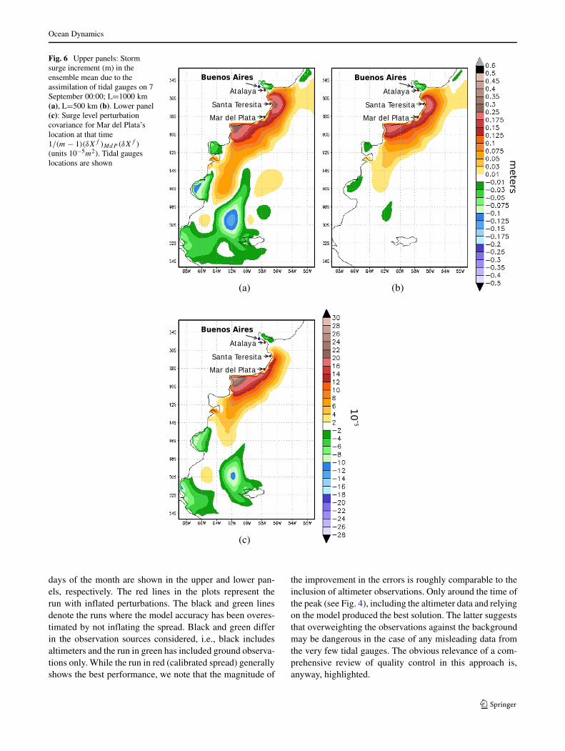
Fig. 6 Upper panels: Stormsurge increment (m) in theensemble mean due to theassimilation of tidal gauges on 7September 00:00; L=1000 km(a), L=500 km (b). Lower panel(c): Surge level perturbationcovariance for Mar del Plata’slocation at that time1/(m − 1)(δXf )MdP (δXf )
(units 10−5m2). Tidal gaugeslocations are shown
-
days of the month are shown in the upper and lower pan-els, respectively. The red lines in the plots represent therun with inflated perturbations. The black and green linesdenote the runs where the model accuracy has been overes-timated by not inflating the spread. Black and green differin the observation sources considered, i.e., black includesaltimeters and the run in green has included ground observa-tions only. While the run in red (calibrated spread) generallyshows the best performance, we note that the magnitude of
the improvement in the errors is roughly comparable to theinclusion of altimeter observations. Only around the time ofthe peak (see Fig. 4), including the altimeter data and relyingon the model produced the best solution. The latter suggeststhat overweighting the observations against the backgroundmay be dangerous in the case of any misleading data fromthe very few tidal gauges. The obvious relevance of a com-prehensive review of quality control in this approach is,anyway, highlighted.
Ocean Dynamics
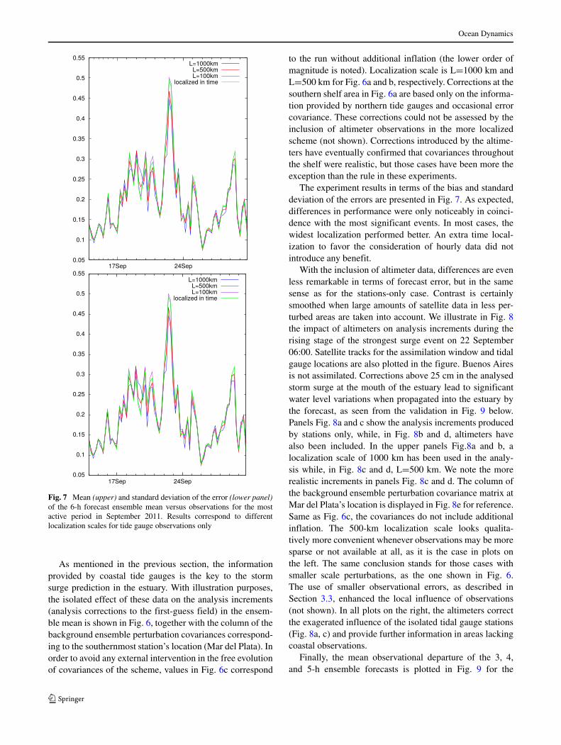
Fig. 7 Mean (upper) and standard deviation of the error (lower panel)of the 6-h forecast ensemble mean versus observations for the mostactive period in September 2011. Results correspond to differentlocalization scales for tide gauge observations only
As mentioned in the previous section, the informationprovided by coastal tide gauges is the key to the stormsurge prediction in the estuary. With illustration purposes,the isolated effect of these data on the analysis increments(analysis corrections to the first-guess field) in the ensem-ble mean is shown in Fig. 6, together with the column of thebackground ensemble perturbation covariances correspond-ing to the southernmost station’s location (Mar del Plata). Inorder to avoid any external intervention in the free evolutionof covariances of the scheme, values in Fig. 6c correspond
to the run without additional inflation (the lower order ofmagnitude is noted). Localization scale is L=1000 km andL=500 km for Fig. 6a and b, respectively. Corrections at thesouthern shelf area in Fig. 6a are based only on the informa-tion provided by northern tide gauges and occasional errorcovariance. These corrections could not be assessed by theinclusion of altimeter observations in the more localizedscheme (not shown). Corrections introduced by the altime-ters have eventually confirmed that covariances throughoutthe shelf were realistic, but those cases have been more theexception than the rule in these experiments.
The experiment results in terms of the bias and standarddeviation of the errors are presented in Fig. 7. As expected,differences in performance were only noticeably in coinci-dence with the most significant events. In most cases, thewidest localization performed better. An extra time local-ization to favor the consideration of hourly data did notintroduce any benefit.
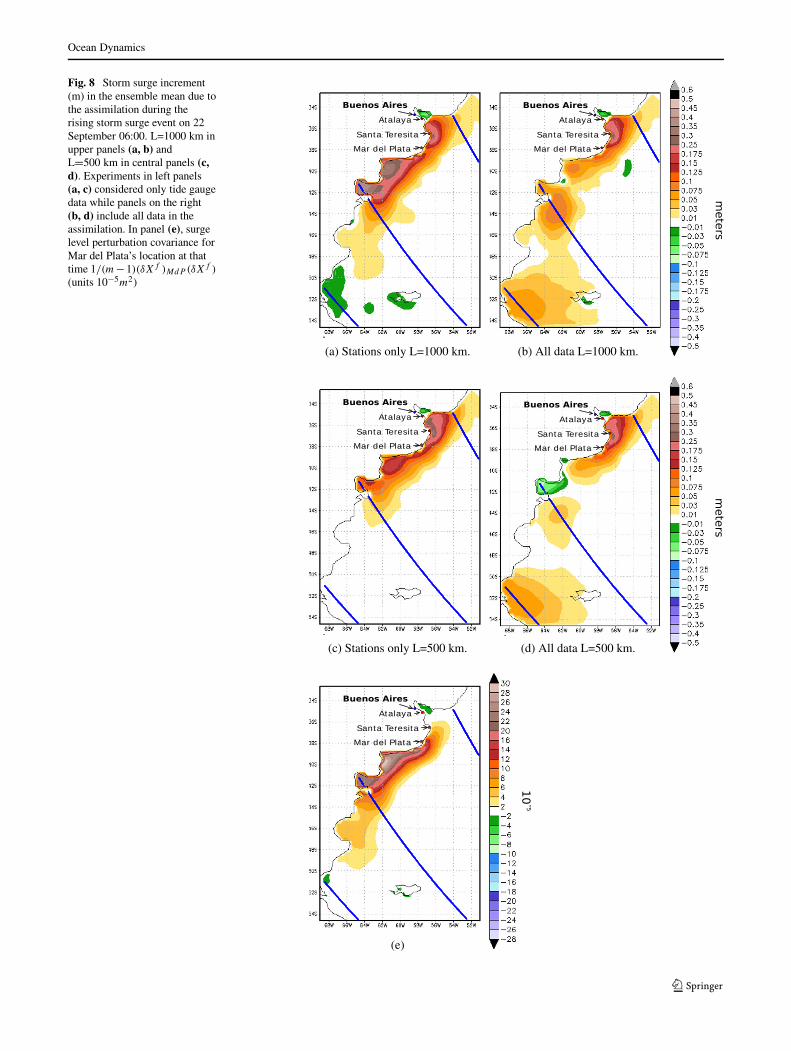
With the inclusion of altimeter data, differences are evenless remarkable in terms of forecast error, but in the samesense as for the stations-only case. Contrast is certainlysmoothed when large amounts of satellite data in less per-turbed areas are taken into account. We illustrate in Fig. 8the impact of altimeters on analysis increments during therising stage of the strongest surge event on 22 September06:00. Satellite tracks for the assimilation window and tidalgauge locations are also plotted in the figure. Buenos Airesis not assimilated. Corrections above 25 cm in the analysedstorm surge at the mouth of the estuary lead to significantwater level variations when propagated into the estuary bythe forecast, as seen from the validation in Fig. 9 below.Panels Fig. 8a and c show the analysis increments producedby stations only, while, in Fig. 8b and d, altimeters havealso been included. In the upper panels Fig.8a and b, alocalization scale of 1000 km has been used in the analy-sis while, in Fig. 8c and d, L=500 km. We note the morerealistic increments in panels Fig. 8c and d. The column ofthe background ensemble perturbation covariance matrix atMar del Plata’s location is displayed in Fig. 8e for reference.Same as Fig. 6c, the covariances do not include additionalinflation. The 500-km localization scale looks qualita-tively more convenient whenever observations may be moresparse or not available at all, as it is the case in plots onthe left. The same conclusion stands for those cases withsmaller scale perturbations, as the one shown in Fig. 6.The use of smaller observational errors, as described inSection 3.3, enhanced the local influence of observations(not shown). In all plots on the right, the altimeters correctthe exagerated influence of the isolated tidal gauge stations(Fig. 8a, c) and provide further information in areas lackingcoastal observations.
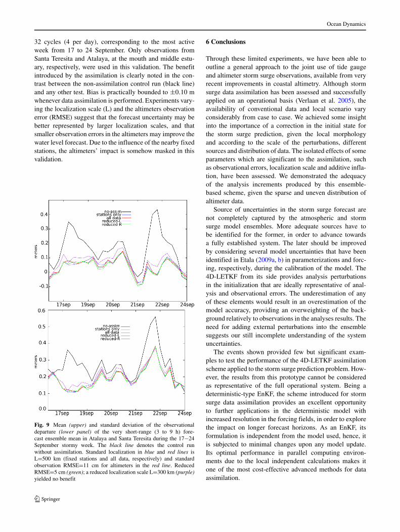
Finally, the mean observational departure of the 3, 4,and 5-h ensemble forecasts is plotted in Fig. 9 for the
Ocean Dynamics
Fig. 8 Storm surge increment(m) in the ensemble mean due tothe assimilation during therising storm surge event on 22September 06:00. L=1000 km inupper panels (a, b) andL=500 km in central panels (c,d). Experiments in left panels(a, c) considered only tide gaugedata while panels on the right(b, d) include all data in theassimilation. In panel (e), surgelevel perturbation covariance forMar del Plata’s location at thattime 1/(m−1)(δXf )MdP (δXf )
(units 10−5m2)
-
Ocean Dynamics
32 cycles (4 per day), corresponding to the most activeweek from 17 to 24 September. Only observations fromSanta Teresita and Atalaya, at the mouth and middle estu-ary, respectively, were used in this validation. The benefitintroduced by the assimilation is clearly noted in the con-trast between the non-assimilation control run (black line)and any other test. Bias is practically bounded to ±0.10 mwhenever data assimilation is performed. Experiments vary-ing the localization scale (L) and the altimeters observationerror (RMSE) suggest that the forecast uncertainty may bebetter represented by larger localization scales, and thatsmaller observation errors in the altimeters may improve thewater level forecast. Due to the influence of the nearby fixedstations, the altimeters’ impact is somehow masked in thisvalidation.
Fig. 9 Mean (upper) and standard deviation of the observationaldeparture (lower panel) of the very short-range (3 to 9 h) fore-cast ensemble mean in Atalaya and Santa Teresita during the 17−24September stormy week. The black line denotes the control runwithout assimilation. Standard localization in blue and red lines isL=500 km (fixed stations and all data, respectively) and standardobservation RMSE=11 cm for altimeters in the red line. ReducedRMSE=5 cm (green); a reduced localization scale L=300 km (purple)yielded no benefit
6 Conclusions
Through these limited experiments, we have been able tooutline a general approach to the joint use of tide gaugeand altimeter storm surge observations, available from veryrecent improvements in coastal altimetry. Although stormsurge data assimilation has been assessed and successfullyapplied on an operational basis (Verlaan et al. 2005), theavailability of conventional data and local scenario varyconsiderably from case to case. We achieved some insightinto the importance of a correction in the initial state forthe storm surge prediction, given the local morphologyand according to the scale of the perturbations, differentsources and distribution of data. The isolated effects of someparameters which are significant to the assimilation, suchas observational errors, localization scale and additive infla-tion, have been assessed. We demonstrated the adequacyof the analysis increments produced by this ensemble-based scheme, given the sparse and uneven distribution ofaltimeter data.
Source of uncertainties in the storm surge forecast arenot completely captured by the atmospheric and stormsurge model ensembles. More adequate sources have tobe identified for the former, in order to advance towardsa fully established system. The later should be improvedby considering several model uncertainties that have beenidentified in Etala (2009a, b) in parameterizations and forc-ing, respectively, during the calibration of the model. The4D-LETKF from its side provides analysis perturbationsin the initialization that are ideally representative of anal-ysis and observational errors. The underestimation of anyof these elements would result in an overestimation of themodel accuracy, providing an overweighting of the back-ground relatively to observations in the analyses results. Theneed for adding external perturbations into the ensemblesuggests our still incomplete understanding of the systemuncertainties.
The events shown provided few but significant exam-ples to test the performance of the 4D-LETKF assimilationscheme applied to the storm surge prediction problem. How-ever, the results from this prototype cannot be consideredas representative of the full operational system. Being adeterministic-type EnKF, the scheme introduced for stormsurge data assimilation provides an excellent opportunityto further applications in the deterministic model withincreased resolution in the forcing fields, in order to explorethe impact on longer forecast horizons. As an EnKF, itsformulation is independent from the model used, hence, itis subjected to minimal changes upon any model update.Its optimal performance in parallel computing environ-ments due to the local independent calculations makes itone of the most cost-effective advanced methods for dataassimilation.
Ocean Dynamics
The most important result we obtained in this workwas the remarkable positive impact of the data assimila-tion on the short-range surge prediction at the mid andouter Rıo de la Plata. The impact at the inner estuarywas not tested directly, but can be inferred. The strongestreduction of the error in the forecasted storm surge levelwas obtained by introducing the assimilation in the fore-cast cycle. Objective measures derived from differences inparameterization details were negligible when comparedwith the overall impact of the data assimilation. Satellitealtimetry data are very useful in the current scenario. Nev-ertheless, the value of extra off-shore information couldnot be fully assessed, due to the absence of real-time datafrom tide gauges in extensive areas along the Argentinecoast.
These preliminary results suggest that numerical predic-tion of the storm surge on the Argentine coast would benefitfrom the availability of real-time observations through anadvanced assimilation method. We have demonstrated theimpact of an improved initial state in the short-range fore-cast. The magnitude of the impact obtained at the mouthand middle estuary with the assimilation suggests that asignificant improvement in the storm surge forecast atthe populated head may be achieved, particularly whenwarning-levels are expected. This ongoing work is a partof a collaborative effort aimed at enhancing operationalcapabilities at the SHN.
Acknowledgments We are thankful to E. Kalnay and J. Ruiz fortheir comments and discussions on this work. This work was par-tially supported under grant PIDDEF 046/10, Ministry of Defense.C. Romero and S.M. Alonso provided support to the validation. Tothe anonymous reviewers whose remarks contributed to improve themanuscript. MS also acknowledges support from EUMETSAT/CNESDSP/OT/12-2118 and CONICET-YPF PIO 133-20130100242.
References
Altaf MU, Butler T, Mayo T, Luo X, Dawson C, Heemink AW, HoteitI (2014) A comparison of ensemble Kalman filters for storm surgeassimilation. Mon Weather Rev 142(8):2899–2914
Butler T, Altaf MU, Dawson C, Hoteit I, Luo X, Mayo T (2012) Dataassimilation within the advanced circulation (ADCIRC) modelingframework for hurricane storm surge forecasting. Mon WeatherRev 140(7):2215–2231
Canizares R, Heemink AW, Vested HJ (1998) Application of advanceddata assimilation methods for the initialisation of storm surgemodels. J Hydraul Res 36(4):655–674
Cipollini P, Benveniste J, Bouffard J, Emery W, Fenoglio-Marc L,Gommenginger C, Griffin D, Høyer J, Kurapov A, Madsen Ket al (2010) The role of altimetry in coastal observing systems.Proceedings of OceanObs 9
Etala P (2009a) Dynamic issues in the SE South America storm surgemodeling. Nat Hazards 51:79–95
Etala P (2009b) On the accuracy of atmospheric forcing for extra-tropical storm surge prediction. Nat Hazards 51(1):49–61
Evensen G (1994) Sequential data assimilation with a nonlinear quasi-geostrophic model using Monte Carlo methods to forecast errorstatistics. J Geophys Res 99(C5):10143–10162
Heemink AW, Kloosterhuis H (1990) Data assimilation for non-lineartidal models. Int J Numer Methods Fluids 11(8):1097–1112
Hunt BR, Kostelich EJ, Szunyogh I (2007) Efficient data assimila-tion for spatiotemporal chaos: a local ensemble transform Kalmanfilter. Physica D: Nonlinear Phenomena 230(12):112–126
Kalnay E, Li H, Miyoshi T, Yang SC, Ballabrera-Poy J (2007) 4DVaror ensemble Kalman filter? Tellus 59(5 09):758–773
Li Y, Peng S, Yan J, Xie L (2013) On improving storm surge fore-casting using an adjoint optimal technique. Ocean Modelling 72:185–197
Lionello P, Sanna A, Elvini E, Mufato R (2006) A data assimilationprocedure for operational prediction of storm surge in the northernAdriatic Sea. Cont Shelf Res 26(4):539–553
Miyoshi T, Yamane S (2007) Local ensemble transform Kalman filter-ing with an AGCM at a T159/L48 resolution. Mon Weather Rev135(11):3841–3861
Naeije M, Schrama E, Scharroo R (2000) The Radar AltimeterDatabase System project RADS, Geoscience and Remote SensingSymposium, IGARSS 2000, IEEE 2000, International, vol 2
Ott E, Hunt BR, Szunyogh I, Zimin AV, Kostelich EJ, Kostelich M,Corazza M, Sauer T, Kalnay E, Patil DJ, Yorke JA (2004) A localensemble Kalman filter for atmospheric data assimilation. Tellus56A:415–428
Peng SQ, Xie L (2006) Effect of determining initial conditions byfour-dimensional variational data assimilation on storm surgeforecasting. Ocean Model 14.1:1–18
Philippart M, Gebraad A, Scharroo R, Roest M, Vollebregt E, JacobsA, van den Boogaard H, Peters H (1998) Data assimilation withaltimetry techniques used in a tidal model, 2nd program. DATUM2 Project NRSP-2 98-19. Tech. rep., Netherlands Remote SensingBoard (BCRS)
Saraceno M, D’Onofrio EE, Fiore ME, Grismeyer WH (2010) Tidemodel comparison over the Southwestern Atlantic Shelf. ContShelf Res 30(17):1865–1875
van Velzen N, Verlaan M (2007) COSTA a problem solving environ-ment for data assimilation applied for hydrodynamical modelling.Meteorol Z 16(6):777–793
Verlaan M, Heemink AW (1997) Tidal flow forecasting using reducedrank square root filters. Stoch Hydrol Hydraul 11:349–368
Verlaan M, Zijderveld A, de Vries H, Kroos J (2005) Operationalstorm surge forecasting in the netherlands: developments in thelast decade. Phil Trans R Soc A: Math, Phys Eng Sci 363(1831):1441–1453
Wei M, Toth Z, Wobus R, Zhu Y (2008) Initial perturbations basedon the ensemble transform (ET) technique in the NCEP globaloperational forecast system. Tellus 60A:62–79