Embed Size (px)
Citation preview

Articles
An Integrated Strategy for Grassland EasementAcquisition in the Prairie Pothole Region, USAJohann Walker,* Jay J. Rotella, Charles R. Loesch, Randy W. Renner, James K. Ringelman,Mark S. Lindberg, Randal Dell, Kevin E. Doherty
J. Walker, R. Dell, R.W. Renner, J.K. RingelmanDucks Unlimited, Inc., Great Plains Regional Office, 2525 River Road, Bismarck, North Dakota 58503-9011
J.J. RotellaDepartment of Ecology, Montana State University, Bozeman, Montana 59717-3460
C.R. Loesch, K.E. DohertyUnited States Fish and Wildlife Service, 3425 Miriam Avenue, Bismarck, North Dakota 58501-7926
M.S. LindbergDepartment of Biology and Wildlife and Institute of Arctic Biology, University of Alaska Fairbanks,Fairbanks, Alaska 99775-7500
Abstract
Acquisition of perpetual grassland easements is a principal tactic used by the United States Fish and Wildlife Service(USFWS) and its partners to protect nesting habitat for migratory birds in the Prairie Pothole Region of North and SouthDakota, USA. This public–private partnership resulted in the conservation of .344,000 ha of grassland during 1998–2012.Past easement acquisition has been targeted to landscapes with greatest expected accessibility to breeding duck pairswithout active consideration of probability of conversion or cost of protection. The rising cost of easement acquisition inrecent years indicates that re-evaluation and refinement of the easement acquisition strategy could help to improveprogrammatic outcomes. We assessed regional patterns of easement acquisition during 1998–2012, evaluated the currenttargeting strategy, and used a combination of publicly available and proprietary geospatial data to develop an easement-targeting Geographic Information System that integrated information about conversion probability and protection costwith current targeting criteria. Our assessment indicated that grassland protection was negatively affected by rising landprices during 1998–2012. In the 5 y between 2008 and 2012, about 100,000 ha of grassland were protected at a cost of $83million (U.S. dollars). The 2008–2012 acquisitions represented 30% of total protection during 1998–2012 but composed47% of the total expenditure. We observed strong evidence that easements were targeted to priority landscapes bothbefore and after formalization of the USFWS conservation strategy in 2004. We also found evidence of an opportunity toincrease efficiency of future acquisitions. We identified 0.9 million ha of currently unprotected priority grassland in theregion with greater than expected conversion risk and smaller than expected protection cost. We suggest that futuregrassland easement acquisition be refocused on this refined priority area and that an adaptive approach to futureeasement acquisition (including targeted acquisitions, directed monitoring, and data-based decisions) provides a logicalframework for implementation of this new strategy and will facilitate continued conservation success.
Keywords: agricultural landscapes; Anatinae; conservation planning; ducks; land protection; private lands conservation
Received: May 23, 2013; Accepted: August 6, 2013; Published Online Early: August 2013; Published: December 2013
Citation: Walker J, Rotella JJ, Loesch CR, Renner RW, Ringelman JK, Lindberg MS, Dell R, Doherty KE. 2013. An integratedstrategy for grassland easement acquisition in the Prairie Pothole Region, USA. Journal of Fish and Wildlife Management4(2):267–279; 31944-687X. doi: 10.3996/052013-JFWM-035
Copyright: All material appearing in the Journal of Fish and Wildlife Management is in the public domain and may bereproduced or copied without permission unless specifically noted with the copyright symbol �. Citation of thesource, as given above, is requested.
The findings and conclusions in this article are those of the author(s) and do not necessarily represent the views of theU.S. Fish and Wildlife Service.
* Corresponding author: [email protected]
Journal of Fish and Wildlife Management | www.fwspubs.org December 2013 | Volume 4 | Issue 2 | 267

Introduction
The Prairie Pothole Region of North and South Dakota(hereafter, PPR) is a globally important region both foragriculture and migratory birds. Most land in the PPR isprivately owned and used for production of small grains,row-crops, or livestock (Johnson et al. 1994; Dohertyet al., in press). North and South Dakota are majorproducers of wheat and cattle, and recently the plantedarea of row crops in these states, particularly corn andsoybeans, has increased (USDA 2007). For example,during 2006–2011, 271,000 ha of grassland transitionedto corn and soybeans in the Dakotas (Wright andWimberly 2013). The native grasslands and shallowwetlands of the PPR provide continentally significantbreeding habitat for populations of wetland- andgrassland-dependent migratory birds (Skagen andThompson 2001; Kushlan 2002; PPJV 2005). During1998–2012, this region supported an average populationof 7.6 million (range = 4.5 M–12.5 million) breedingducks (Anas spp. and Aythya spp.; Zimpfer et al. 2012) athigher recorded densities than any other area on theNorth American continent. Grassland provides attractiveand secure nesting habitat for breeding ducks (Green-wood et al. 1995; Reynolds et al. 2001; Horn et al. 2005;Stephens et al. 2005); thus, conservation of grassland inthe PPR is a high priority under the North AmericanWaterfowl Management Plan (USFWS and CanadianWildlife Service 1986).
Purchasing perpetual easements that protect grass-land from conversion to cropland, but retain land inprivate ownership, is currently the principal tactic usedby the United States Fish and Wildlife Service (USFWS)and other conservation organizations to permanentlyprotect nesting habitat for ducks and other wetland- andgrassland-dependent migratory birds in the PPR (PPJV2005). Although the USFWS has acquired grasslandeasements in the PPR since 1970, the majority (73%) ofthe total protected area has been acquired since 1998.During 1998–2012, USFWS and its conservation partnersspent $156.2 million on grassland easement acquisitionin the PPR (T. Fairbanks and B. Mulvaney, USFWS Region6 Realty Program, unpublished data). Ducks Unlimited,Inc. was the major provider of private matching funds,with contributions totaling $26.9 million or about 17% oftotal funding. This public–private partnership resulted inthe permanent protection of .344,000 ha of grasslandby easements acquired during 1998–2012 (T. Fairbanksand B. Mulvaney, unpublished data).
In the past, a combination of professional judgment,logistical considerations, and breeding pair informationhas been used to target easement acquisitions tolandscapes with the greatest abundance of breedingduck pairs (USFWS 1992). This approach was furtherdeveloped and formalized by USFWS in 2004 (GAO 2007).Since 2005, easements have been prioritized based onexpected accessibility of grassland nesting habitat tobreeding duck pairs estimated from ongoing countsurveys (i.e., Four Square Mile Breeding WaterfowlPopulation and Production Survey; Cowardin et al.1995; Reynolds et al. 2006) and other potential migratorybird and endangered species benefits. The objective of
this approach is to direct grassland easement acquisitionto landscapes with the greatest potential benefit toupland nesting ducks (Anas spp. and Aythya spp.) and tomaximize the area of protected grassland in thesepriority landscapes.
Recent assessments of grassland easement objectivesindicate that if projected trends in grassland loss andprotection cost continue, current acreage goals forgrassland protection in the PPR will not be achieved(GAO 2007; Doherty et al., in press). During 1998–2012,average inflation-adjusted corn prices in North and SouthDakota increased 210% (from $1.89/bushel to $5.88/bushel) while average inflation-adjusted cropland rentalrate in the PPR increased 61% (from $109/acre to $175/acre; USDA, National Agricultural Statistics Service 2012).Concurrently, the average inflation-adjusted cost ofgrassland easements increased 300% from $195/acre in1998 to $778/acre in 2012. Conversion of grassland tocropland has also increased as the market price ofprofitable commodity crops such as corn has increased(Stubbs 2007; Stephens et al. 2008; Rashford et al. 2011;Wright and Wimberly 2013).
Increased commodity prices, increased cropland value,and rapid cropland expansion in the PPR indicate a needto adapt the current prioritization strategy for grasslandeasement acquisition in response to increased protectioncost. Additional need for refined targeting is evident inthe rising demand for easements from private landown-ers, which consistently exceeds available funding (B.Mulvaney, personal communication). Because conversionprobability and protection cost are spatially variable(Rashford et al. 2011; Walker 2011), incorporatinginformation about these factors may help focus grass-land easement acquisition to sites with greatest value forbreeding ducks and greater risk of loss relative toprotection cost and thereby lead to more cost-effectiveuse of limited funding (Newburn et al. 2005; Pressey et al.2007; Bode et al. 2008; Polasky 2008).
We investigated grassland easement acquisition byUSFWS and its conservation partners in the PPR during1998–2012 with three primary objectives: 1) assess theeffect of rising protection costs on grassland easementacquisition at the regional level; 2) evaluate whetherformalization of targeting strategy based on 2004changed the spatial distribution of acquisitions; and 3)develop a new, spatially explicit easement-targetingGeographic Information System (GIS) to facilitate morestrategic easement acquisition by augmenting the exist-ing GIS-based system with information about probabilityof grassland conversion and cost of protection.
Methods
Analysis areaThe analysis area comprised the Prairie Pothole Region
of North and South Dakota (Figure 1). The climate, landuse, and physical geography of this region are well-described elsewhere (e.g., Bluemle 1991; Johnson et al.1994; Millett et al. 2009). Because of the PPR’simportance to breeding ducks and other grassland birds,this area is the focus of easement acquisition efforts and
Grassland Easement Acquisition in the Prairie Pothole Region J. Walker et al.
Journal of Fish and Wildlife Management | www.fwspubs.org December 2013 | Volume 4 | Issue 2 | 268

accounts for 80% (0.9 million ha) of the total area of alltypes of easements held by USFWS nationwide (USFWS2011). We separated North and South Dakota in allcomparative analyses, because easement programs inthe two states are delivered by different personneland are subject to different state-level administrativeconstraints.
Assessment of recent easement acquisitionsWe assessed temporal patterns in region-wide grass-
land easement acquisition in North and South Dakotaduring 1998–2012 with data from the USFWS Region 6Realty Program (T. Fairbanks and B. Mulvaney, unpub-lished data). Specifically, we used the R environment(R 2.15.1; R Development Core Team 2012) and thecontributed package ggplot2 (Wickham 2009) to exam-ine the total number of U.S. dollars spent (in 2005dollars), the total area protected, and the unit cost ofgrassland protection (in 2005 dollars per hectare) by yearfor each state. We looked for patterns in the year-to-yeardata consistent with recent trends in commodity pricesand cropland rental rate, including increased overall cost,decreased area protected, and increased protection costper unit area.
Evaluation of current targeting strategyWe investigated whether the easement acquisition
strategy developed by USFWS in 2004 and subsequentlyadopted by the Prairie Pothole Joint Venture (jointventures are partnerships established under the NorthAmerican Waterfowl Management Plan to help conservethe continent’s waterfowl populations and habitats)
changed targeting of easements to priority landscapesafter it was implemented in 2005. We used publiclyavailable and proprietary geospatial data (Table 1;publicly available data in Data S1, proprietary USFWSgrassland easement data available by special requestfrom the current Project Leader, USFWS Region 6 HAPET,Bismarck, North Dakota) and standard tools in ArcGISDesktop 10.0 (ESRI, Inc., Redlands, California) to comparethe spatial distribution of grassland protected during1998–2004 (preconservation strategy) with the spatialdistribution of grassland protected during 2005–2012(postconservation strategy). To avoid errors whencalculating areas, all spatial analyses were conducted inthe same map projection and datum (Universal Trans-verse Mercator Zone 14 North, North American Datum1983). We ran the repair geometry tool on all featureclass layers before converting to grid data. We used thesnap raster tool to align all grid layers to a common gridwith the same extent as the analysis area.
We characterized the spatial distribution of grasslandeasements in terms of current priorities by combiningthe USFWS grassland easement layer with the 3-classlayer of USFWS acquisition priority based on accessibilityto breeding duck pairs (Pairs Class 1 comprises areasaccessible to $23 pairs/km2 on average, Pairs Class 2comprises areas accessible to 16–22 pairs/km2, and PairsClass 3 comprises areas accessible to 10–15 pairs/km2).These priority classes encompass the spatial distributionof uplands accessible to 94% of the expected breedingduck pairs in the PPR (4,343,248 pairs). Specifically, weconverted the USFWS priority layer to a 30-m grid andused the Zonal Statistics tool in ArcGIS to calculate the
Figure 1. Location and extent of the Prairie Pothole Region in North and South Dakota.
Grassland Easement Acquisition in the Prairie Pothole Region J. Walker et al.
Journal of Fish and Wildlife Management | www.fwspubs.org December 2013 | Volume 4 | Issue 2 | 269
majority (dominant) priority class associated with eachgrassland easement tract.
After we calculated the dominant priority classassociated with existing grassland easements acquiredduring 1998–2012, we used a chi-squared goodness-of-fit test (Sokal and Rolf 1995) to statistically compare thespatial distribution of protected grasslands before andafter implementation of the USFWS conservation strat-egy in 2005 (Fisher and Dills 2012). The null hypothesispredicted no change in the distribution of grasslandeasements relative to the priority classes in the periodbefore (pre-2005) and after (post-2004) the implementa-tion of the formal conservation strategy. We consideredchi-squared statistics that had a probability of #0.05under the null hypothesis of identical distributions to bestatistically significant, and we conducted all statisticaltests in the R environment (R 2.15.1; R Development CoreTeam 2012). We predicted that ongoing targeting ofgrassland easement acquisition to areas with greaterbreeding pair abundance had concentrated easements inthe higher ranking priority classes throughout the life ofthe program (USFWS 1992) and that formalization of theconservation strategy in 2004 would be associated withan increase in the number of easements acquired inhigher ranking priority classes.
Development of the integratedeasement-prioritization GIS
To facilitate refined targeting of easement acquisition,we combined the existing USFWS easement priorityclasses based on habitat value for breeding duck pairswith information about spatial variation in correlates ofconversion probability and protection cost. We wereparticularly interested in identification of unprotectedgrasslands in USFWS priority class 1 or 2 (areas accessibleto $16 breeding duck pairs/km2) with greater expectedprobability of conversion and reduced expected cost ofprotection relative to the remaining unprotected grass-land in the priority area. We used ArcGIS to combine theexisting USFWS priority layer based on spatial variation in
accessibility of grassland to breeding ducks with twoadditional layers describing spatial variation in probabil-ity of conversion and cost of protection (Table 1; dataavailable in Data S1). To avoid errors when calculatingareas, all spatial analyses were conducted in the samemap projection (Universal Transverse Mercator Zone 14North, North American Datum 1983). We ran the repairgeometry tool on all feature class layers beforeconverting to grid data. We used the snap raster toolto align all grid layers to a common grid with the sameextent as the analysis area.
Conversion probability of grassland in the analysis areais related to Land Capability Class (LCC): an index ofsuitability for cropping (Stephens et al. 2008; Rashford etal. 2011). Land Capability Class is an ordinal variable thatranges from 1 to 8 and increases with increasinglimitations to cultivation (NRCS 1995). As a broad-scaleindex to conversion probability, we used LCC data fromthe USDA Soil Survey Geographic database (NRCS 1995).We combined the eight LCC values from the Soil SurveyGeographic database (table physical name: muaggatt,column physical name: niccdcd [nonirrigated capabilityclass]) into 3 risk classes (Risk Class1 = LCC values 1 and2, Risk Class 2 = LCC values 3 and 4, and Risk Class 3 =LCC 5–8). We based our three classes on the results ofRashford et al. (2011), who found that conversionprobability averaged 0.95%/y in our analysis area, andthese classes were associated with a 3-fold (Risk Class 3to Risk Class 2) and 1.5-fold (Risk Class 2 to Risk Class 1)increase in annual conversion probability, respectively.
We used producer-reported average county-levelcropland rental rates for 2010–2012 (USDA, NationalAgricultural Statistics Service 2012) as an index tovariation in easement cost. These rental rates arecorrelated (r = 0.97) with per hectare cost of easementsacross the study area (Walker 2011). We used theInterpolation tool in ArcGIS with average county-specificcropland rental rate during 2010–2012 assigned to thegeographic centroid of the outer extent of each countyto calculate a continuous surface of inverse-distance-
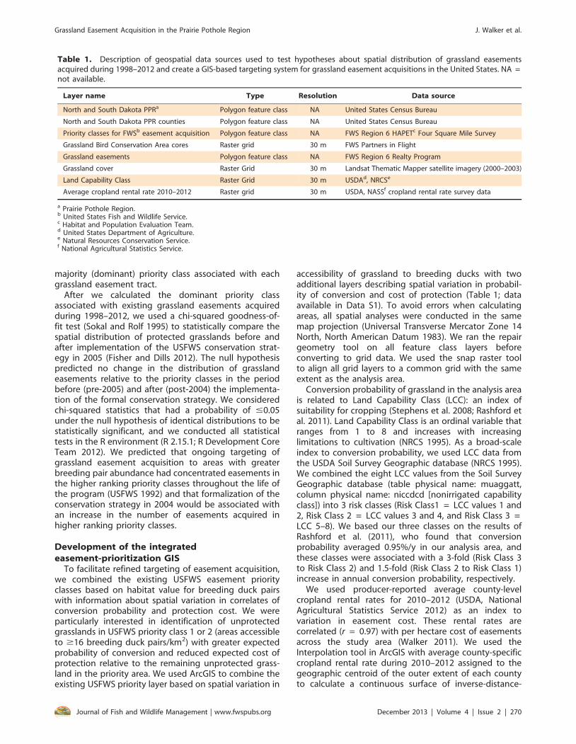
Table 1. Description of geospatial data sources used to test hypotheses about spatial distribution of grassland easementsacquired during 1998–2012 and create a GIS-based targeting system for grassland easement acquisitions in the United States. NA =not available.
Layer name Type Resolution Data source
North and South Dakota PPRa Polygon feature class NA United States Census Bureau
North and South Dakota PPR counties Polygon feature class NA United States Census Bureau
Priority classes for FWSb easement acquisition Polygon feature class NA FWS Region 6 HAPETc Four Square Mile Survey
Grassland Bird Conservation Area cores Raster grid 30 m FWS Partners in Flight
Grassland easements Polygon feature class NA FWS Region 6 Realty Program
Grassland cover Raster Grid 30 m Landsat Thematic Mapper satellite imagery (2000–2003)
Land Capability Class Raster Grid 30 m USDAd, NRCSe
Average cropland rental rate 2010–2012 Raster grid 30 m USDA, NASSf cropland rental rate survey data
a Prairie Pothole Region.b United States Fish and Wildlife Service.c Habitat and Population Evaluation Team.d United States Department of Agriculture.e Natural Resources Conservation Service.f National Agricultural Statistics Service.
Grassland Easement Acquisition in the Prairie Pothole Region J. Walker et al.
Journal of Fish and Wildlife Management | www.fwspubs.org December 2013 | Volume 4 | Issue 2 | 270

weighted county-level cropland rental rates. We thencombined the resulting 30-m grid into a 3-class protection-cost index layer based on the empirical quantiles of theobserved cropland rental-rate distribution across theanalysis area during 2010–2012 (Cost Class 1 = lowestone-third of rental rate, Cost Class 2 = middle one-third,and Cost Class 3 = top one-third).
To develop a single layer for targeting easementacquisition, we combined the USFWS priority layerbased on accessibility to breeding pairs, the grasslandconversion risk layer based on LCC, and the protection-cost layer based on cropland rental rate. First, we usedthe Map Algebra tool to sum the pairs, risk, and costlayers. Then, to adjust the resulting summed layer tothe remaining unprotected grassland in the analysisarea, we multiplied it by a binary land-cover grid (1 =unprotected grassland as of 2012 associated with22 hectare) Grassland Bird Conservation Area Cores[Johnson et al. 2010], 0 = other land-cover classes).The result was a 30-m grid describing remainingunprotected priority grassland on a summed scalefrom 3 to 9. Unprotected grassland with a summedvalue of 3 was therefore associated with $23 breedingduck pairs/km2, LCC rated 1 or 2, and cropland rentalrate in the lowest one-third of the distribution (i.e.,Pairs Class value = 1, Risk Class value = 1, and CostClass value = 1). Unprotected grassland with asummed value of 9 was associated with #15 breedingduck pairs/km2, LCC rated 5, 6, 7, or 8, and in the topone-third of the cropland rental rate distribution. Wethen recombined the seven grid sum values andcreated three integrated priority classes. Priority 1included grid values 3 and 4, Priority 2 included gridvalues 5 and 6, and Priority 3 included grid values 7, 8,and 9. Priority 1 consisted of unprotected grasslands
that fell below grid value 1 on no more than onecriterion, Priority 2 consisted of unprotected grasslandsthat fell below grid value 1 on no more than twocriteria, and Priority 3 consisted of unprotectedgrasslands that fell below grid value 1 on at leasttwo criteria. This prioritization was based on two ideas.First, we thought a relatively simple structure wouldresult in a more readily implemented conservationstrategy (Knight et al. 2008). Second, and moreimportantly, this structure focused on unprotectedgrassland within the existing highest priority area withlikely greatest probability of conversion and lowestcost of protection, which was our primary interest.
Results
Assessment of recent easement acquisitionsDuring 1998–2012, USFWS and its conservation
partners spent $149.0 million (all amounts adjusted toconstant Gross Domestic Product deflated 2005 U.S.dollars) on grassland easement acquisition in the PPR.More than 344,000 ha of grassland were protected at anaverage cost of $432/ha. Most of those funds ($104.9million) were spent to protect grassland (191,000 ha) inSouth Dakota. Average unit costs of grassland protectionwere $549/ha in South Dakota and $287/ha in NorthDakota. Despite a substantial increase in expenditureduring the study period, there was little realized gain inthe annual rate of protection. Funds expended ongrassland easement acquisition increased 3-fold in SouthDakota from $3.7 million in 1998 to $11.8 million in 2012and 9.7-fold in North Dakota from $0.6 million in 1998 to$5.8 million in 2012 (Figure 2). Area protected in SouthDakota ranged from 7,100 ha in 2010 to 19,300 ha in2000 and averaged 12,750 ha/yr during 1998–2012. Area
Figure 2. Annual expenditure (2005 U.S. Dollars [USD]) of the FWS perpetual grassland easement acquisition program in the PrairiePothole Region of North and South Dakota, 1998–2012.
Grassland Easement Acquisition in the Prairie Pothole Region J. Walker et al.
Journal of Fish and Wildlife Management | www.fwspubs.org December 2013 | Volume 4 | Issue 2 | 271

protected in North Dakota ranged from 3,800 ha in 1998to 16,300 ha in 2000 and averaged 10,300 ha/yr during1998–2012 (Figure 3). In South Dakota, average unit costof protection ranged from $201/ha in 1998 to $1,103/hain 2010. In North Dakota, average unit cost of protectionranged from $136/ha in 2002 to $568/ha in 2012(Figure 4).
Evaluation of current targeting strategyWe rejected the null hypothesis that easements were
identically distributed among USFWS priority classesbefore and after the 2005 implementation of the USFWSconservation strategy. The observed distribution ofeasements relative to the distribution of unprotectedgrassland in USFWS priority classes differed from
Figure 3. Area (ha) of perpetual grassland easements acquired by the U.S. Fish and Wildlife Service to prevent conversion ofgrassland bird nesting habitat to cropland during 1998–2012 in the Prairie Pothole Region of North and South Dakota.
Figure 4. Unit cost (2005 U.S. Dollars [USD]/ha) of perpetual grassland easements acquired by the U.S. Fish and Wildlife Service toprevent conversion of grassland bird nesting habitat to cropland in the Prairie Pothole Region of North and South Dakota, 1998–2012.
Grassland Easement Acquisition in the Prairie Pothole Region J. Walker et al.
Journal of Fish and Wildlife Management | www.fwspubs.org December 2013 | Volume 4 | Issue 2 | 272

expectations in both South (x23 = 17.67, P = 0.0005) andNorth (x23 = 25.61, P , 1024) Dakota. Counter to ourprediction, these results, although statistically significant,did not provide material evidence of practically signifi-cant changes associated with implementation of theconservation strategy (Figure 5). There were 3,032 and792 easements purchased in South and North Dakota,respectively, before the implementation of the conser-vation strategy. In South Dakota, 72% of easements wereexpected in Pairs Class 1 landscapes based on observedlocations of easements acquired before the implemen-tation of the conservation strategy, and 72% of the 868easements acquired after 2004 were in Pairs Class 1landscapes. In North Dakota, 89% of easements wereexpected in Pairs Class 1 landscapes based on observedlocations of easements acquired before the implemen-tation of the conservation strategy, and 93% of the 920easements acquired after 2004 were in Pairs Class 1landscapes.
Development of the integratedeasement-prioritization GIS
There were 3.2 million ha of unprotected grasslands inthe analysis area located in priority landscapes accessibleto $10 duck pairs/km2. Unprotected grassland wasdistributed unevenly among USFWS Pairs Classes, with1.8 million ha (56%) in Pairs Class 1, 0.8 million ha (25%)in Pairs Class 2, and 0.6 million ha (19%) in Pairs Class 3.Among conversion classes within priority landscapes, weobserved 1.0 million ha (32%) of unprotected grasslandin Risk Class 1, 1.2 million ha (39%) in Risk Class 2 and 0.9million ha (29%) in Risk Class 3. Among Cost Classes,
there were 1.4 million ha (44%) of unprotected prioritygrassland in Cost Class 1 (cropland rental rate from $72/ha to $124/ha), 1.3 million ha (40%) in Cost Class 2(cropland rental rate from $125/ha to $216/ha), and 0.5million ha (16%) in Cost Class 3 (cropland rental rate from$217/ha to $400/ha). When current USFWS Pairs Classeswere combined with the new Risk Classes and CostClasses, there were 0.9 million ha of Priority 1, 1.7 millionha of Priority 2, and 0.6 million ha of Priority 3unprotected grasslands in the analysis area (Figure 6).Most of the Priority 1 and Priority 2 unprotectedgrassland was located in central and northwest NorthDakota with a band of Priority 1 and Priority 2 grasslandin the westernmost portion of the analysis area in SouthDakota (Figure 7).
Discussion
Recent assessments of regional habitat protectionrates indicate regional goals for grassland easementacquisition (PPJV 2005) will not be achieved givencurrent grassland loss rates and increasing protectioncosts (GAO 2007; Doherty et al., in press). Our analyses ofrecent grassland protection activity in the PPR corrobo-rated these results. Largely due to increasing unit cost ofprotection, the annualized rate of grassland protection inthe PPR did not increase during 1998–2012. The effect ofdiminishing buying power in an appreciating landmarket was most apparent in recent years. In the 5 ybetween 2008 and 2012, about 100,000 ha wereprotected at a cost of $83 million. This acquisitionrepresented 30% of the total area protected during1998–2012 but 47% of total expenditure. Increases in
Figure 5. Expected and observed distribution of perpetual grassland easements acquired by the U.S. Fish and Wildlife Service toprevent conversion of grassland bird nesting habitat to cropland in the Prairie Pothole Region of North and South Dakota amongpriority classes based on expected accessibility to breeding duck pairs. Expected distribution corresponds to the distribution ofeasements acquired prior to the implementation of a formal conservation strategy in 2005. Observed distribution corresponds to thedistribution of easements acquired after the implementation of a formal conservation strategy in 2005.
Grassland Easement Acquisition in the Prairie Pothole Region J. Walker et al.
Journal of Fish and Wildlife Management | www.fwspubs.org December 2013 | Volume 4 | Issue 2 | 273

funding to the easement program have only kept pacewith increasing land values and, as a result, the annualrate of protection has not increased. For example, in1998, 22,000 ha were protected for $5.3 million, and in2012, 22,000 ha were protected for $20.8 million. The14% average year-over-year increase in easement ex-penditure only matches recent increases in protectioncost, mandating cost-efficient targeting of resources tounprotected grasslands. Given a continued trend ofincreasing cropland value in the PPR, we suspect a largerarea of at-risk priority grassland will ultimately beprotected if conversion risk and protection cost areformally integrated into the conservation strategy (New-burn et al. 2005; GAO 2007).
At the parcel-level, grassland easements acquiredduring 1998–2012 were effectively targeted to thehighest priority landscapes in terms of the currentconservation strategy, and formalization of the conser-vation strategy in 2004 did not change the pattern oftargeting. Over 95% of the grassland easements acquiredduring 1998–2012 were located in landscapes associatedwith the greatest expected accessibility to breeding duckpairs. This result has two implications. First, parcel-level
prioritization decisions made by field personnel over the15-y analysis period were compatible with the regionaltargeting strategy implemented by USFWS in 2004.Second, our analysis provided evidence that regional-scale prioritization schemes and local-scale, parcel-specific acquisition decisions can be coherent. Thus,efforts to add information about conversion risk andprotection cost to the current targeting strategy havethe potential for successful cross-scale implementation.
Implementation of easement-prioritization GIS will bemost effective when parcel-level protection decisions aremade in the context of the local knowledge base. Thestatistical relationships that formed the basis for our GISdo not predict parcel-level characteristics with certainty.Rather, they describe expected long-term, broad-scaleoutcomes. For example, at the regional and program-matic level, our GIS can direct easement acquisition tolandscapes with greater expected abundance of breed-ing pairs, greater expected risk of conversion, and smallerexpected cost of protection. It can also facilitateavoidance of areas with greater expected breeding-pairabundance but smaller expected conversion risk orgreater protection cost. Therefore, as an initial step, the
Figure 6. Area of remaining unprotected grassland in the Prairie Pothole Region of North and South Dakota by priority classes (1= highest priority, 2 = high priority, 3 = lower priority) corresponding to variation in expected abundance of breeding duck pairs(Pairs), risk of conversion (Risk), cost of protection (Cost), and Pairs, Risk, and Cost combined (Combined).
Grassland Easement Acquisition in the Prairie Pothole Region J. Walker et al.
Journal of Fish and Wildlife Management | www.fwspubs.org December 2013 | Volume 4 | Issue 2 | 274

Figure 7. Location and extent of remaining unprotected grassland (in million [M] of hectares) in the Prairie Pothole Region ofNorth and South Dakota by priority classes corresponding to variation in expected abundance of breeding duck pairs, risk ofconversion, and cost of protection.
Grassland Easement Acquisition in the Prairie Pothole Region J. Walker et al.
Journal of Fish and Wildlife Management | www.fwspubs.org December 2013 | Volume 4 | Issue 2 | 275

easement-prioritization GIS could be used by fieldpersonnel to provide a ranking of competing opportu-nities. Then, local knowledge could be applied by fieldpersonnel to improve the initial rankings. For example, iffield personnel know a local landowner who plans toconvert a parcel that has relatively small expectedconversion probability or a relatively costly parcel isoffered in a bargain sale or as a partial donation, thenthose parcels should be given additional priority.Nonetheless, when parcel-specific knowledge is lacking,acquisitions made using the rankings provided by oureasement-prioritization GIS are likely to balance costsand benefits in terms of the potential benefits lost perunit cost more effectively than would a strategy basedstrictly on breeding pair abundance.
Global change in economics, demographics, andclimate is predicted to increase worldwide demandfor food and energy, while increasing the uncertaintyof supply (Ramankutty et al. 2008; Searchinger et al.2008; Cirera and Masset 2010). As a result, expansion ofcultivated land (Wright and Wimberly 2013) ontoformer grasslands is likely to continue in the PPR.Integrated targeting of easement acquisitions can helpto counter this force by directing grassland protectionefforts to at-risk areas with a larger benefit–cost ratio.Our assessment indicated there were 3.3 million ha ofunprotected grasslands in the priority areas defined bythe current targeting strategy based on abundance ofbreeding duck pairs. This area was nearly 10 timeslarger than the 344,000 ha protected during 1998–2012. We suggest that future grassland easementacquisitions would likely be more cost-efficient ifefforts were refocused on the 0.9-million-ha highest-priority unprotected grasslands identified by ouranalysis. Targeting of grassland easement acquisitionto a smaller area with greater expected probability ofconversion and smaller expected cost of protectioncould provide needed support to easement acquisitionefforts during a time when purchasing power is beingdiminished by rising land prices. For example, thisapproach could help to both maximize the effect oflimited funding and buy time for efforts to affect land-use policies that promote grassland conservation(Carriazo et al. 2009).
Renewed focus on the strategic foundation of thegrassland easement program could help to mitigate thenegative effects of increasing protection cost andconversion rate. Our work to develop an integratedtargeting system addresses some potential deficienciesof the acquisition strategy, but in many respects ourtargeting utility represents a working hypothesis sup-ported by data and past studies. In keeping with theprinciples of Strategic Habitat Conservation (i.e., thecurrent USFWS adaptive habitat-conservation paradigmbased on iterative planning, implementation, andevaluation; USFWS 2008), we suggest that implementa-tion of an integrated strategy could proceed as part of anadaptive framework for easement acquisition guided bydirected monitoring and evaluation. By testing criticalassumptions on a periodic basis, an adaptive approachprovides needed structure for evaluating progress
toward near-term programmatic objectives and formaking strategic adjustments (Rissman et al. 2007;Conroy and Peterson 2009). For example, our proposedtargeting strategy is focused on protection of tracts withgreater than average values of breeding pair abundanceand conversion probability and smaller than averagevalues of protection cost. These assumptions could beperiodically evaluated by comparing the characteristicsof acquired easements with data generated by monitor-ing 1) distribution and abundance of breeding ducks,2) conversion of grassland to cropland, and 3) costof protection across the analysis area. The resultingcomparison of observation with predictions wouldprovide the objective basis for adapting easement-acquisition efforts to the current ecological, economic,and political environment. By continually testing keyassumptions and incorporating new information, thisapproach would help ensure continued success of thegrassland easement program in the changing environ-ment of the PPR.
Supplemental Material
Please note: The Journal of Fish and Wildlife Managementis not responsible for the content or functionality of anysupplemental material. Queries should be directed to thecorresponding author for the article.
Data S1. Publicly available geospatial and tabulardata for analysis of easement acquisition in the PPR ofNorth and South Dakota is contained in the zip foldertitled PPR_Easement_Acquisition
Found at DOI: http://dx/doi.org/10.3996/052013-JFWM-035.S1 (47.4 MB ZIP).
Reference S1. Carriazo F, Claassen R, Cooper J. 2009.Crop insurance, disaster payments, and incentives forland use change in agriculture: a preliminary assessment.American Agricultural Economics Association, Milwau-kee, Wisconsin.
Found at DOI: http://dx/doi.org/10.3996/052013-JFWM-035.S2; also available at http://ageconsearch.umn.edu/bitstream/49218/2/Carriazo_AAEA09_April27.pdf(142 KB PDF)
Reference S2. Conroy MJ, Peterson JT. 2009.Integrating management, research, and monitoring:balancing the 3-legged stool. Pages 2–10 in CederbaumSB, Faircloth BC, Terhune TM, Thompson JJ, Carroll JP,editors. Gamebird 2006: Quail VI and Perdix XII. 31 May–4June 2006. Athens, Georgia: Warnell School of Forestryand Natural Resources.
Found at DOI: http://dx/doi.org/10.3996/052013-JFWM-035.S3; also available at http://people.oregonstate.edu/,peterjam/ConroyandPeterson2009.pdf (324 KBPDF)
Reference S3. Cowardin LM, Shaffer TL, Arnold PM.1995. Evaluations of duck habitat and estimation of duckpopulation sizes with a remote-sensing-based system.Biological Science Report 2. Washington, D.C.: U.S. Fishand Wildlife Service.
Grassland Easement Acquisition in the Prairie Pothole Region J. Walker et al.
Journal of Fish and Wildlife Management | www.fwspubs.org December 2013 | Volume 4 | Issue 2 | 276

Found at DOI: http://dx/doi.org/10.3996/052013-JFWM-035.S4; also available at http://www.npwrc.usgs.gov/resource/birds/duckhab/ (2,489 KB PDF)
Reference S4. Kushlan JA. 2002. Waterbird conser-vation for the Americas: North American waterbirdconservation plan, version 1. Washington, D.C.: WaterbirdConservation for the Americas.
Found at DOI: http://dx/doi.org/10.3996/052013-JFWM-035.S5; also available at http://www.waterbirdconservation.org/pdfs/plan_files/complete.pdf (6,268 KBPDF)
Reference S5. [NRCS] Natural Resources Conserva-tion Service. 1995. Soil survey geographic survey(SSURGO) database: data use information. Miscellaneouspublication 1527. Fort Worth, Texas: National Cartogra-phy and GIS Center.
Found at DOI: http://dx/doi.org/10.3996/052013-JFWM-035.S6; also available at ftp://ftp.igsb.uiowa.edu/gis_library/Support_Data/Soils/SSURGO.PDF (339 KBPDF)
Reference S6. [PPJV] Prairie Pothole Joint Venture.2005. Prairie Pothole Joint Venture implementation plan:introduction. Denver: U.S. Fish and Wildlife Service.
Found at DOI: http://dx/doi.org/10.3996/052013-JFWM-035.S7; also available at http://www.ppjv.org/implement2.htm (2,886 KB PDF)
Reference S7. Stubbs M. 2007. Land conversion inthe Northern Plains. Washington, D.C.: CongressionalResearch Service, Library of Congress.
Found at DOI: http://dx/doi.org/10.3996/052013-JFWM-035.S8; also available at http://new.nationalaglawcenter.org/wp-content/uploads/assets/crs/RL33950.pdf(869 KB PDF)
Reference S8. [USDA] U.S. Department of Agricul-ture. 2007. Census of agriculture.
Found at DOI: http://dx/doi.org/10.3996/052013-JFWM-035.S9; also available at http://www.agcensus.usda.gov/Publications/2007/Full_Report/ (6,611 KB PDF)
Reference S9. [USFWS] U.S. Fish and Wildlife Serviceand Canadian Wildlife Service. 1986. North AmericanWaterfowl Management Plan: a strategy for cooperation.Washington, D.C.: U.S. Fish and Wildlife Service.
Found at DOI: http://dx/doi.org/10.3996/052013-JFWM-035.S10; also available at http://www.fws.gov/birdhabitat/nawmp/files/NAWMP.pdf (12.7 MB PDF)
Reference S10. [USFWS] U.S. Fish and WildlifeService. 2008. Strategic habitat conservation handbook.Washington D.C.: Department of the Interior, U.S. Fishand Wildlife Service Division of Realty.
Found at DOI: http://dx/doi.org/10.3996/052013-JFWM-035.S11; also available at http://www.fws.gov/landscape-conservation/pdf/SHCHandbook.pdf (2,390KB PDF)
Reference S11. [USFWS] U.S. Fish and WildlifeService. 2011. Annual report of lands under the control
of the U.S. Fish and Wildlife Service. Washington D.C.:Department of the Interior, U.S. Fish and Wildlife ServiceDivision of Realty.
Found at DOI: http://dx/doi.org/10.3996/052013-JFWM-035.S12; also available at http://www.fws.gov/refuges/realty/archives/pdf/2010_Annual_Report_of_Lands.pdf (2,688 KB PDF)
Reference S12. [USGAO] U.S. Government Account-ability Office. 2007. Prairie Pothole Region: at the currentpace of acquisitions the U.S. Fish and Wildlife Service isunlikely to achieve its habitat protection goals formigratory birds. GAO Report 07-1093.
Found at DOI: http://dx/doi.org/10.3996/052013-JFWM-035.S13; also available at http://www.gao.gov/assets/270/267291.pdf (6,542 KB PDF)
Reference S13. Zimpfer NL, Rhodes WE, SilvermanED, Zimmerman GS, Richkus KD. 2012. Trends in duckbreeding populations, 1955–2012. Washington, D.C.: U.S.Department of the Interior.
Found at DOI: http://dx/doi.org/10.3996/052013-JFWM-035.S14; also available at http://www.fws.gov/migratorybirds/Newreportspublications/PopulationStatus/Trends/2012_Trend_Report_final.pdf (2,317 KB PDF)
Acknowledgments
This project resulted from discussions with conservationworkers from a wide range of agencies and organizationsincluding the United States Fish and Wildlife Service, TheNorth Dakota Game and Fish Department, and The SouthDakota Department of Game, Fish, and Parks. Themanuscript was improved by critical reviews provided bythe Subject Editor, G. Soulliere, and an anonymous referee.
Any use of trade, product, or firm names is fordescriptive purposes only and does not imply endorse-ment by the U.S. Government.
References
Bluemle JP. 1991. The face of North Dakota. Revisededition. Educational Series 21. Bismarck: North DakotaGeological Survey. Available: https://www.dmr.nd.gov/ndgs/Publication_List/education.asp (August 2013).
Bode M, Wilson KA, Brooks TM, Turner WR, MittermeierRA, McBride MF, Underwood EC, Possingham, HP.2008. Cost-effective global conservation spending isrobust to taxonomic group. Proceedings of theNational Academy of Sciences 105:6498–6501.
Carriazo F, Claassen R, Cooper J. 2009. Crop insurance,disaster payments, and incentives for land use changein agriculture: a preliminary assessment. AmericanAgricultural Economics Association, Milwaukee, Wis-consin (see Supplemental Material, Reference S1,http://dx/doi.org/10.3996/052013-JFWM-035.S2); alsoavailable: http://ageconsearch.umn.edu/bitstream/49218/2/Carriazo_AAEA09_April27.pdf (August 2013).
Cirera X, Masset E. 2010. Income distribution trends andfuture food demand. Philosophical Transactions of theRoyal Society B: Biological Sciences 365:2821–2834.
Grassland Easement Acquisition in the Prairie Pothole Region J. Walker et al.
Journal of Fish and Wildlife Management | www.fwspubs.org December 2013 | Volume 4 | Issue 2 | 277

Conroy MJ, Peterson JT. 2009. Integrating management,research, and monitoring: balancing the 3-leggedstool. Pages 2–10 in Cederbaum SB, Faircloth BC,Terhune TM, Thompson JJ, Carroll JP, editors. Game-bird 2006: Quail VI and Perdix XII. 31 May–4 June 2006.Athens, Georgia: Warnell School of Forestry andNatural Resources (see Supplemental Material, Refer-ence S2, http://dx/doi.org/10.3996/052013-JFWM-035.S3); also available: http://people.oregonstate.edu/,peterjam/ConroyandPeterson2009.pdf (August 2013).
Cowardin LM, Shaffer TL, Arnold PM. 1995. Evaluations ofduck habitat and estimation of duck population sizeswith a remote-sensing-based system. Biological Sci-ence Report 2. Washington, D.C.: U.S. Fish and WildlifeService (see Supplemental Material, Reference S3,http://dx/doi.org/10.3996/052013-JFWM-035.S4); alsoavailable: http://www.npwrc.usgs.gov/resource/birds/duckhab/ (August 2013).
Doherty KE, Ryba AJ, Stemler CL, Neimuth ND, MeeksWA. In press. Conservation planning in an era ofchange: state of the U.S. Prairie Pothole Region.Wildlife Society Bulletin. Available: http://onlinelibrary.wiley.com/doi/10.1002/wsb.284/full (August 2013).
Fisher JR, Dills B. 2012. Do private conservation activitiesmatch science-based conservation priorities? PloSONE 7: e46429.
Greenwood RJ, Sargeant AB, Johnson DH, Cowardin LM,Shaffer TL. 1995. Factors associated with duck nestsuccess in the prairie pothole region of Canada.Wildlife Monographs 128.
Horn DJ, Phillips ML, Koford RR, Clark WR, Sovada MA,Greenwood RJ. 2005. Landscape composition, patchsize, and distance to edges: interactions affecting duckreproductive success. Ecological Applications 15:1367–1376.
Johnson RR, Granfors DA, Niemuth ND, Estey ME,Reynolds RR. 2010. Delineating grassland bird conser-vation areas in the US Prairie Pothole Region. Journalof Fish and Wildlife Management 1:38–42.
Johnson DH, Haseltine SD, Cowardin LM. 1994. Wildlifehabitat management on the northern prairie land-scape. Landscape and Urban Planning 28:5–21.
Knight AT, Cowling RM, Rouget, M, Balmford, A,Lombard, AT, Campbell, BM. 2008. Knowing but notdoing: selecting priority conservation areas and theresearch/implementation gap. Conservation Biology22:610–617.
Kushlan JA. 2002. Waterbird conservation for the Amer-icas: North American waterbird conservation plan,version 1. Washington, D.C.: Waterbird Conservationfor the Americas (see Supplemental Material, ReferenceS4, http://dx/doi.org/10.3996/052013-JFWM-035.S5);also available: http://www.waterbirdconservation.org/pdfs/plan_files/complete.pdf (August 2013).
Millett B, Johnson WC, Guntenspergen G. 2009. Climatetrends of the North American prairie pothole region1906–2000. Climatic Change 93:243–267.
[NRCS] Natural Resources Conservation Service. 1995. Soilsurvey geographic survey (SSURGO) database: datause information. Miscellaneous publication 1527. FortWorth, Texas: National Cartography and GIS Center(see Supplemental Material, Reference S5, http://dx/doi.org/10.3996/052013-JFWM-035.S6); also available:ftp://ftp.igsb.uiowa.edu/gis_library/Support_Data/Soils/SSURGO.PDF (August 2013).
Newburn D, Reed S, Berck P, Merenlender A. 2005.Economics and land use change in prioritizing privateland conservation. Conservation Biology 19:1411–1420.
[PPJV] Prairie Pothole Joint Venture. 2005. Prairie PotholeJoint Venture implementation plan: introduction.Denver: U.S. Fish and Wildlife Service (see Supplemen-tal Material, Reference S6, http://dx/doi.org/10.3996/052013-JFWM-035.S7); also available: http://www.ppjv.org/implement2.htm (August 2013).
Polasky S. 2008. Why conservation planning needssocioeconomic data. Proceedings of the NationalAcademy of Sciences 105:6505–6506.
Pressey RL, Cabeza M, Watts ME, Cowling RM, Wilson KA.2007. Conservation planning in a changing world.Trends in Ecology and Evolution 22:583–592.
R Development Core Team. 2012. R: a language andenvironment for statistical computing. Version 2.15.1.Vienna: R Development Core Team. Available: http://www.R-project.org (August 2013).
Ramankutty N, Foley JA, Olejniczak NJ. 2008. Land useand soil resources. Pages 23–40 in Braimoh AK, VlekPLG, editors. Land-use change and global foodproduction. New York: Springer Verlag.
Rashford BS, Walker JA, Bastian CT. 2011. Economics ofgrassland conversion to cropland in the PrairiePothole Region. Conservation Biology 25:276–284.
Reynolds RE, Shaffer TL, Loesch CR, Cox RR Jr. 2006. TheFarm Bill and duck production in the Prairie PotholeRegion: increasing the benefits. Wildlife SocietyBulletin 34:963–974.
Reynolds RE, Shaffer TL, Renner RW, Newton WE, BattBDJ. 2001. Impact of the Conservation ReserveProgram on duck recruitment in the US Prairie PotholeRegion. Journal of Wildlife Management 65:765–780.
Rissman, AR, Lozier L, Comendant T, Kareiva P, KieseckerJM, Rebecca M, Merenlender AM. 2007. Conservationeasements: biodiversity protection and private use.Conservation Biology 21:709–718.
Searchinger T, Heimlich R, Houghton RA, Dong F, ElobeidA, Fabiosa J, Tokgoz S, Hayes D, Yu TH. 2008. Use ofUS croplands for biofuels increases greenhouse gasesthrough emissions from land-use change. Science 319:1238–1240.
Skagen SK, Thompson G. 2001. Northern Plains/PrairiePotholes regional shorebird conservation plan. Wash-ington, D.C.: U.S. Fish and Wildlife Service.
Sokal RR, Rohlf FJ. 1995. Biometry. 3rd edition. New York:WH Freeman.
Stephens SE, Rotella JJ, Lindberg MS, Taper ML, Ringel-man JK. 2005. Duck nest survival in the Missouri
Grassland Easement Acquisition in the Prairie Pothole Region J. Walker et al.
Journal of Fish and Wildlife Management | www.fwspubs.org December 2013 | Volume 4 | Issue 2 | 278

Coteau of North Dakota: landscape effects at multiplespatial scales. Ecological Applications 15:2137–2149.
Stephens SE, Walker JA, Blunck DR, Jayaraman A, NaugleDE, Ringelman JK, Smith AJ. 2008. Predicting risk ofhabitat conversion in native temperate grasslands.Conservation Biology 22:1320–1330.
Stubbs M. 2007. Land conversion in the Northern Plains.Washington, D.C.: Congressional Research Service,Library of Congress (see Supplemental Material, Refer-ence S7, http://dx/doi.org/10.3996/052013-JFWM-035.S8); also available: http://new.nationalaglawcenter.org/wp-content/uploads/assets/crs/RL33950.pdf (August2013).
[USDA] U.S. Department of Agriculture. 2007. Census ofagriculture. (see Supplemental Material, Reference S8,http://dx/doi.org/10.3996/052013-JFWM-035.S9; alsoavailable: http://www.agcensus.usda.gov/Publications/2007/Full_Report/ (August 2013).
[USDA] U.S. Department of Agriculture, National Agricul-tural Statistics Service. 2012. Quick Stats 2.0. Available:http://quickstats.nass.usda.gov/ (August 2013).
[USFWS] U.S. Fish and Wildlife Service. 1992. U.S. Fish andWildlife Service Region 6 administrative and enforce-ment guidelines for perpetual grassland easements:Small Wetlands Acquisition Program. Revised February1997. Lakewood, Colorado: U.S. Fish and WildlifeService. (Living FWS document available by requestfrom FWS Region 6 Easement Coordinator).
[USFWS] U.S. Fish andWildlife Service. 2008. Strategic habitatconservation handbook. Washington, D.C.: Departmentof the Interior, U.S. Fish and Wildlife Service Division ofRealty (see Supplemental Material, Reference S10, http://dx/doi.org/10.3996/052013-JFWM-035.S11); also avail-able: http://www.fws.gov/landscape-conservation/pdf/SHCHandbook.pdf (August 2013).
[USFWS] U.S. Fish and Wildlife Service. 2011. Annualreport of lands under the control of the U.S. Fish andWildlife Service. Washington, D.C.: Department of theInterior, U.S. Fish and Wildlife Service Division of Realty
(see Supplemental Material, Reference S11, http://dx/doi.org/10.3996/052013-JFWM-035.S12); also avail-able: http://www.fws.gov/refuges/realty/archives/pdf/2010_Annual_Report_of_Lands.pdf (August 2013).
[USFWS] U.S. Fish and Wildlife Service and CanadianWildlife Service. 1986. North American WaterfowlManagement Plan: a strategy for cooperation. Wash-ington, D.C.: U.S. Fish and Wildlife Service (seeSupplemental Material, Reference S9, http://dx/doi.org/10.3996/052013-JFWM-035.S10); also available:http://www.fws.gov/birdhabitat/nawmp/files/NAWMP.pdf (August 2013).
[USGAO] U.S. Government Accountability Office. 2007.Prairie Pothole Region: at the current pace ofacquisitions the US Fish and Wildlife Service is unlikelyto achieve its habitat protection goals for migratorybirds. GAO Report 07-1093. (see Supplemental Mate-rial, Reference S12, http://dx/doi.org/10.3996/052013-JFWM-035.S13), also available: http://www.gao.gov/assets/270/267291.pdf (August 2013).
Walker J. 2011. Survival of duck nests, distribution ofduck broods, and habitat conservation targeting inthe Prairie Pothole Region. Doctoral dissertation.Fairbanks: University of Alaska Fairbanks.
Wickham H. 2009. ggplot2: elegant graphics for dataanalysis. New York: Springer.
Wright CK, Wimberly MC. 2013. Recent land use changein the Western Corn Belt threatens grasslands andwetlands. Proceedings of the National Academy ofSciences 110: 4134–4139.
Zimpfer NL, Rhodes WE, Silverman ED, Zimmerman GS,Richkus KD. 2012. Trends in duck breeding popula-tions, 1955–2012. Washington, D.C.: U.S. Departmentof the Interior (see Supplemental Material, ReferenceS13, http://dx/doi.org/10.3996/052013-JFWM-035.S14),also available: http://www.fws.gov/migratorybirds/Newreportspublications/PopulationStatus/Trends/2012_Trend_Report_final.pdf (August 2013).
Grassland Easement Acquisition in the Prairie Pothole Region J. Walker et al.
Journal of Fish and Wildlife Management | www.fwspubs.org December 2013 | Volume 4 | Issue 2 | 279


![Grassland Reserve Program2)[Read-Only].pdf · •First GRP Cooperative Agreement •1,200 acre Conservation Easement •Total Protected Area 3,670 acres •Benefits: exceptional habitat](https://img.pdfslide.us/doc/110x75/5c01c27609d3f2377a8dcc71/grassland-reserve-2read-onlypdf-first-grp-cooperative-agreement-1200.jpg)