Embed Size (px)
Citation preview
University of Massachusetts AmherstScholarWorks@UMass Amherst
Landscape Architecture Masters Theses Collection Landscape Architecture & Regional Planning
Spring 5-2017
An Incremental Intervention in Jakarta: AnEmpowering Infrastructural Approach forUpgrading Informal SettelmentsChristopher H. [email protected]
Follow this and additional works at: https://scholarworks.umass.edu/la_theses
Part of the Urban, Community and Regional Planning Commons, and the Urban Studies andPlanning Commons
This Article is brought to you for free and open access by the Landscape Architecture & Regional Planning at ScholarWorks@UMass Amherst. It hasbeen accepted for inclusion in Landscape Architecture Masters Theses Collection by an authorized administrator of ScholarWorks@UMass Amherst.For more information, please contact [email protected].
Counihan, Christopher H., "An Incremental Intervention in Jakarta: An Empowering Infrastructural Approach for Upgrading InformalSettelments" (2017). Landscape Architecture Masters Theses Collection. 1.Retrieved from https://scholarworks.umass.edu/la_theses/1
AN INCREMENTAL INTERVENTION IN JAKARTA: AN EMPOWERING INFRASTRUCTURAL APPROACH FOR UPGRADING INFORMAL
SETTLEMENTS
A Thesis Presented
By
CHRISTOPHER H. COUNIHAN
Submitted to the Graduate School of the University of Massachusetts Amherst in partial fulfillment
of the requirements for the degrees of
MASTER OF ARCHITECTURE MASTER OF LANDSCAPE ARCHITECTURE
May 2017
Department of Architecture
Department of Landscape Architecture & Regional Planning
AN INCREMENTAL INTERVENTION IN JAKARTA: AN EMPOWERING INFRASTRUCTURAL APPROACH FOR UPGRADING INFORMAL
SETTLEMENTS
A Thesis Presented
By
CHRISTOPHER H. COUNIHAN Approved as to style and content by: _________________________________________________ Kathleen Lugosch, Chair _________________________________________________ Carey Clouse, Member _________________________________________________ Mark Lindhult, Member
___________________________________ Stephen Schreiber, Department Chair Department of Architecture
___________________________________ Elisabeth Hamin, Department Chair Department of Landscape Architecture & Regional Planning
ACKNOWLEDGMENTS
I would like to thank my advisors, Kathleen Lugosch, Carey Clouse, and Mark Lindhult
for their guidance and support.
Thanks are also due to Steven Fenton, Carol Counihan, and Timothy Counihan. Together
their support, contributions, and direction have been invaluable and will forever be appreciated.
I would also like to extend my gratitude to the members of my committee, Lawson Reed
Wulsin Jr., Derek A. Noble, Jason, and Rachel Loeffler for their helpful comments and
suggestions at all stages of this project.
I wish to express my appreciation to Chip Counihan who hosted and guided me in
Jakarta.
A final thank you to all those whose support and friendship helped me to stay focused
and sane throughout this project and who have provided me with encouragement at every step
along the way.
iii
ABSTRACT
AN INCREMENTAL INTERVENTION IN JAKARTA:
AN EMPOWERING INFRASTRUCTURAL APPROACH FOR UPGRADING INFORMAL SETTLEMENTS
MAY 2017
CHRISTOPHER H. COUNIHAN, B.S., SKIDMORE COLLEGE
M.Arch/M.L.A., UNIVERSITY OF MASSACHUSETTS AMHERST
Directed by: Professor Kathleen Lugosch
Incrementalism is a growing movement within multiple design disciplines that approaches design with sustainable, social, and resilient aims structured around participatory, infrastructural, and phased approaches to design. Carefully considered structural and independent infrastructural frameworks allow infill and accretion according to the demands and needs of individuals and communities. This paper outlines the theories, case studies, and conditions driving incrementalism. My research has informed my project proposal for an incremental upgrade of a slum located in Jakarta using a phased, soft infrastructural, resident facilitated upgrade and development strategy creating new housing units, productive landscapes, and urban form. Incremental development will foster the social aims of my project, while affordably, equitably, and efficiently upgrading the standards of living for slum dwellers within the Waduk Pluit community.
iv
TABLE OF CONTENTS
Page
ACKNOWLEDGMENTS………………………………………………………………………...iii
ABSTRACT……………………………………………………………………………………….iv
LIST OF TABLES……………………………………………………..………………………....vii
LIST OF FIGURES………………………………………………………………………...…....viii
CHAPTER
I. INTRODUCTION……………………………………………………………………………….1
A. Argument for Slum Upgrading…………………………………………………………....1 B. Slum Morphology…………………………………………………………………………5
II. INTRODUCTION TO INCREMENTALISM………………………………………………….9
A. Incrementalism……………………………………………………………………….........9 B. Incremental Housing History………………………………………………………….....13
III. JAKARTA……………………………………………………………………………………16
A. Background………………………………………………………………………………16B. Jakarta Slum/Informal Conditions…………………………………………………….....33 C. KIP Slum Upgrading…………………………………………………………………......35
IV. INCREMENTALISM IN ACTION……………………………………………………….....39
A. Underlying Concepts………………………………………………………………….....39
1. How Buildings Learn……………………………………………………………392. Social Urbanism…………………………………………………………………423. Cradle-to-Cradle………………………………………………………………...434. Flexible Housing………………………………………………………………...44
B. Case Studies: Incremental Approaches……………………………………………………48
1. Kowloon Walled City…………………………………………………………...482. Japanese Metabolism……………………………………………………………503. Aranya Community Housing…………………………………………………....56
v
4. Alajandro Aravena………………………………………………………………575. Medellin…………………………………………………………………………606. KIP Successes and Failures……………………………………………………..70
V. KAMPUNG WADUK PLUIT………………………………………………………………...74
A. Kampung Muara Baru - Site in Context…………………………………………………74 B. Waduk Pluit Site Conditions…………………………………………………………......77
VI. PROPOSAL FOR INCREMENTAL INTERVENTION IN JAKARTA……………………83
A. Negatives into Positives………………………………………………………………….83B. Independent Infrastructure…………………………………………………………….....84 C. Kit-of-Parts………………………………………………………………………………85 D. Incremental Development………………………………………………………………..91
VII. PRESENTATION BOARDS………………………………………………………………..96
VIII. CONCLUSION……………………………………………………………………………102
BIBLIOGRAPHY…………………………………………………………………………….....104
vi
LIST OF TABLES
Table Page
1. Population growth in Jakarta………………………………………………………………......18
2. World city populations (municipal)............................................................................................18
3. Jakarta area affected by flooding…………………………………………………………........19
4. Rainfall during past flooding events……………………………………………………….......23
5. Correlation of percentage of slums and of flooded area in Jakarta……………………………29
vii
LIST OF FIGURES
Figure Page
1. Annual growth rate of cities and slums…………………………………………………………1
2. Jakarta’s location in the world and Indonesia…………………………………………………16
3. Developed area expansion 1970, 1980, 1990, and 2000………………………………………17
4. Jakarta slums with 2007 flood superimposed…………………………………………………20
5. Land subsidence and sea level rise……………………………………………………………21
6. Land subsidence in Jakarta 1974-1991 (left) and 1991-2010 (right)………………………….21
7. Subsidence along Jakarta waterfront…………………………………………………………..22
8. Causation, risks, and impacts of land subsidence in Jakarta…………………………………..22
9. Rainfall during past flooding events…………………………………………………………..26
10. Inundation maps for extreme scenarios of flooding………………………………………….26
11. Inundation map for flood events……………………………………………………………...27
12. Mean surface temperatures in Jakarta, 1880-1990 (2000 and 2010 projected)………………28
13. Percentage of unregistered land in Jakarta, 2007 flood superimposed………………………30
14. Stewart Brand shells………………………………………………………………………….39
15. Kowloon Walled City: Incrementalism unchecked………………………………………….49
16. Kanto earthquake aftermath………………………………………………………………….51
17. Tokyo post-WWII……………………………………………………………………………51
18. Tange’s phased framework…………………………………………………………………...52
19. Tange’s plan for Tokyo (1960)……………………………………………………………….53
20. Organizational Framework…………………………………………………………………...53
21. A-frame “artificial” land,” circulation, and spine……………………………………………54
22. Aranya Community housing…………………………………………………………………57
23. Elemental project Villa Verde……………………………………………………………......58
viii
24. Elemental project Villa Verde urban design…………………………………………………60
25. PUI urban fabric typologies, pre PUI………………………………………………………...62
26. PUI circulation hierarchy…………………………………………………………………….63
27. Conditions before PUI project upgrade………………………………………………………64
28. Metrocable serving the PUI…………………………………………………………………..65
29. PUI selective home relocation for green infrastructure upgrades……………………………67
30. PUI circulation, built form, and green infrastructure integrated……………………………..68
31. “Green” infrastructure approaches in PUI…………………………………………………...69
32. PUI circulation, runoff, and green infrastructure upgrade…………………………………...69
33. Jakarta aerial showing focus area……………………………………………………………74
34. Project focus area: Kampung Waduk Pluit…………………………………………………..75
35. Project focus area: Kampung Waduk Pluit…………………………………………………..76
36. Project focus area figure ground: Kampung Waduk Pluit……………………………………77
37. Project focus area: Kampung Waduk Pluit…………………………………………………..79
38. Conditions within Waduk Pluit………………………………………………………………80
39. Water edge conditions in Waduk Pluit……………………………………………………….83
40. Architectural kit-of-parts……………………………………………………………………..86
41. Landscape design kit-of-parts………………………………………………………………...89
42. Project focus area: Kampung Waduk Pluit…………………………………………………..90
43. Phased expansion of Waduk Pluit project……………………………………………………91
44. Phased expansion potential of the dwelling unit module…………………………………….92
45. Phased expansion of productive landscape components……………………………………..92
46. Phased expansion of urban plan and landscape components………………………………...93
47. Architectural details and joinery……………………………………………………………..94
48. Landscape design approaches………………………………………………………………..95
49. Streetscape and urban design approaches……………………………………………………95
ix
1
CHAPTER I
INTRODUCTION
A. Argument for Slum Upgrading
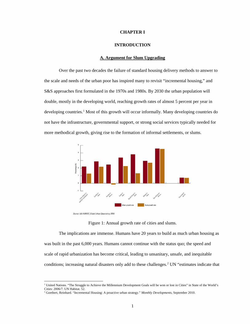
Over the past two decades the failure of standard housing delivery methods to answer to
the scale and needs of the urban poor has inspired many to revisit “incremental housing,” and
S&S approaches first formulated in the 1970s and 1980s. By 2030 the urban population will
double, mostly in the developing world, reaching growth rates of almost 5 percent per year in
developing countries.1 Most of this growth will occur informally. Many developing countries do
not have the infrastructure, governmental support, or strong social services typically needed for
more methodical growth, giving rise to the formation of informal settlements, or slums.
Figure 1: Annual growth rate of cities and slums.
The implications are immense. Humans have 20 years to build as much urban housing as
was built in the past 6,000 years. Humans cannot continue with the status quo; the speed and
scale of rapid urbanization has become critical, leading to unsanitary, unsafe, and inequitable
conditions; increasing natural disasters only add to these challenges.2 UN “estimates indicate that
1 United Nations. “The Struggle to Achieve the Millennium Development Goals will be won or lost in Cities” in State of the World’s Cities: 2006/7. UN Habitat. 52. 2 Goethert, Reinhard. “Incremental Housing: A proactive urban strategy.” Monthly Developments, September 2010.
2
if governments continue with business as usual, then an additional 400 million people will be
drawn into the misery of slum life as the global slum population reaches 1.4 billion in 2020.”3
Traditional “instant” housing approaches are costly, socially disruptive, (frequently)
culturally inappropriate, and overtax limited administrative resources. In the rapidly growing
cities of the developing world, informal construction and expansion, “pay-as-you-go,” is the de-
facto growth pattern, especially in low-income neighborhoods and on the periphery of cities.4
This process accounts for most new housing construction and improvements in developing
cities.5 The informal “sector” already provides about 70 percent of all urban housing in cities of
the developing world, making it the leading supplier in the housing supply chain.6
A problem with informal development patterns is that they can be prohibitively costly to
upgrade. Because informal settlements arise in areas not slated for development, they are devoid
of any significant infrastructure.7 Infrastructure needs are handed off to the private sector,
allowing the settlement’s existence, while reducing government involvement. Upgrading informal
settlements is a method of providing land tenure security to those who inhabit the settlement.8
This gives occupants of the community incentives to upgrade their housing and provides them
with better economic opportunities.9 “The concentration of population and enterprises in urban
areas significantly reduces the unit cost of piped water, sewers, drains, roads, electricity, garbage
collection, transport, health care, and schools.10 However, the cost-effectiveness of infrastructure
investment is greatly reduced when these investments are made too late.”11
Incremental housing involves a step-by-step process. Incremental housing goes by many
names: starter home, phased-development house, or owner-driven house. All act as an integral
3 United Nations. “The Struggle to Achieve the Millennium Development Goals will be won or lost in Cities” in State of the World’s Cities: 2006/7. UN Habitat. 50. 4 IBID 5 IBID 6 IBID 7 IBID 8 Wakely, Patrick and Riley, Elizabeth. The Case for Incremental Housing. Washington, D.C.: The Cities Alliance. 2011. 9 IBID 10 United Nations. “The Struggle to Achieve the Millennium Development Goals will be won or lost in Cities.” 2006/7. 49. 11 IBID
3
urban development processes, providing housing to individuals and communities. Incremental
housing is not quick, immediate, or complete, but provides owners with choice and time. It begins
with a core shelter that may be a kitchen/bathroom unit or a bare lot with the potential for utility
provision. The fundamental component is a multi-purpose room with integrated, or ancillary,
basic kitchen/bath facilities. Homeowners control the expansion of their home based on their
needs and resources over time.12
Incremental housing provides an affordable way to resettle households at a simple
housing and services level, linking the faculty of homeowners and community with larger-scale
city planning. Incremental housing can provide secure title and maximum flexibility in housing
decisions for residents. City expansion can be managed, creating a more predictable and effective
use of limited funds and administrative resources. But incremental housing has functions beyond
housing. It fosters the development of communities, allowing individuals to develop social
networks that can support services, small-scale commercial opportunities, and social mobility.13
Site and services (S&S) describes a strategy tested and implemented in the 1970s and
80s. S&S provided a plot with legal title and water, sanitation, streets, and supporting services.
These projects mimicked existing squatter settlements, but provided institutional support, legal
title, services, and a basic shelter option.14 S&S gradually fell out of favor, partly because it was a
lengthy and incomplete process, and not a typical instant-housing solution.15 Professor Pat
Wakely of University College, London explains, “Site and services was deemed unsuccessful and
discredited. They [projects] were evaluated too soon (after two to three years) and there was
misunderstanding about the criteria and indicators in this process-based type of project.”16 S&S is
being revisited by contemporary architects, urban designers, and city planners. It clearly works
(when evaluated over the long term) due to the growth evident in the communities where adopted
12 United Nations. “The Struggle to Achieve the Millennium Development Goals will be won or lost in Cities.” 2006/7. 49. 13 IBID 14 Goethert. “Incremental Housing: A proactive urban strategy.” 2010. 15 Wakely and Riley. The Case for Incremental Housing. 2011. 16 Goethert. “Incremental Housing: A proactive urban strategy.” 2010.
4
or tested. While construction quality may be marginal, and infrastructure services are lagging,
standards of living and residents prospects have improved.
Incremental housing allows for housing costs to be reduced, acknowledging that poor
households already build and extend dwellings incrementally in response to household needs and
resources. Incremental housing took two approaches with the addition of policy and legal
frameworks: upgrading existing informal settlements with potable water, sanitation, drainage,
electricity, and circulation; and providing legal tenure for new plots on serviced land (S&S)
where households could self-build dwelling units.17
Projects that were “evaluated” one or two years after initial development were incorrectly
assumed to have failed. When revisited a decade or more later, their successes are apparent. The
social and economic benefits of engaging communities and individuals in self-build projects have
become clearer with time. This highlights the need to reassess incremental housing methods and
approaches.18
Successful incremental housing projects build on customary practices. Projects must
focus on minimal interventions, or the absolute, acceptable minimum, rather than what is
ultimately desirable. Projects must establish a sense of identity and place for the homeowners and
the community. This fosters resiliency, where, after a disaster, stability and a sense of support are
inherent. Recent incremental housing interventions promote further development of this concept.
The physical, legal, and policy framework must include support for communities.19
Three basic physical options can provide a framework for subdivision in new settlements:
main streets, main streets with large-lot cluster divisions, and main streets with all lots defined.
The minimal approach is a grid of through-streets and infrastructure networks. The most complete
option provides a fully realized layout with individual lots, streets, and space for public amenities,
utilities, and facilities. All require the main service grids be built first and then expanded upon as
17 Wakely and Riley. The Case for Incremental Housing. 2011. 18 IBID 19 IBID
5
demand requires and resources permit. Infrastructure will develop incrementally alongside
dwelling units.20
Starter cores provide one multi-use room with kitchen/toilet facilities. Finished room
starter cores offer immediate identity, habitability, and place, helping to define a neighborhood
and street. Cores should be built with strict guidelines to provide a model and structure for safe
and predictable expansion while encouraging good construction practices. Households value
flexible expansion opportunities, local materials and skills, and vernacular appearance and
aesthetics. Settlers can focus on outfitting, program, adjacencies, and finish, while professionals
can focus on safety, sanitary, and economic factors including ensuring earthquake and hurricane
safe construction, the provision of water and sanitation, the initial cost, and mobilization time.
Many inventive, and exotic ideas have been offered, but most are unsuited for broader
applications. A straightforward plan rooted in situ is best.21
Given the rapid urbanization occurring in the developing world and the high proportion
of those settling in new and existing slums, it is important to understand slum conditions,
typologies, and locations so that early interventions can be made to prevent conditions from
worsening.
B. Slum Morphology
Informality is not confined to places of poverty and therefore should not only be
associated with slums. Every economy has a formal and informal sector, and so do all cities.
Cities are shaped by informal processes just as much as informal processes. “Informal
settlements” have become defined as urban fragments or districts that form and function largely
outside the formal control of the state. Informal settlements are not entirely unplanned or
undesigned because they are a result of strategic and speculative decisions by the occupants.22
20 Wakely and Riley. The Case for Incremental Housing. 2011. 21 IBID 22 Martin, R. and Mathema, A. “Clash of civilizations.” Informal Settlements. 2006.
6
Most informal settlements have a range of rental, squatting, and informal entitlements.
Land tenure is frequently irregular, unclear, and oftentimes contested, rather than being strictly
illegal.23 A slum is defined by the UN as “any dwelling with more than three people per room or
without access to clean water, sanitation, security, or durable shelter.”24 The formation of
informal settlements and slums indicates growth in population and urban employment that has not
been matched or anticipated by the capacity of the state or the formal market to provide
affordable housing.25
Three primary modes or processes of informal settlement growth have been identified.26
The first is called “settling,” or inhabitation on unclaimed and unbounded land as villages and
towns have done over millennia. The second has been called “inserting”: development along the
uninhabited abandoned, or leftover fragments of urban space. The third mode is “attaching”:
developmental accretions or growth within, or attached onto, structures of the formal city. Room
by room growth patterns can be a contiguous accretion that extends horizontally and vertically to
about five or six storeys. This process is driven by the slow accumulation of scarce resources over
time. Construction materials are commonly recycled and can range from plastic, timber, steel,
concrete, canvas, rubber, bamboo, to brick. Room types and their arrangement reflect local
culture, climate, urban density, and geography.27
Informal settlements and slums can be understood in eight ‘types.’28 District slums are
contiguous. Most notable large urban slums are large mixed-use districts that incorporate retail
and industrial functions. These develop over a long period of time, and are often the site of
upgrading as the informal becomes infiltrated by the formal city.29
23 Jenkins, P. “Informal settlements: infernal and eternal?” Informal Settlements. 2006. 24 United Nations. “The Struggle to Achieve the Millennium Development Goals will be won or lost in Cities.” 2006/7 25 Dovey, Kim and King, Ross. “Forms of Informality: Morphology and Visibility of Informal Settlements.” Built Environment 37, no. 1. 2011. 26 IBID 27 Dovey and King. “Forms of Informality: Morphology and Visibility of Informal Settlements.” 2011. 28 IBID 29 IBID
7
Waterfront slums are settlements on marginal land between a water body, and the formal
city. Previously, this land was considered unsafe for development due to flooding. Oftentimes an
ecological or economic connection exists to the water. These settlements can spread into and
above the water on stilts and boats.30
Escarpment slums develop on parts of urban topography that are considered too steep to
build upon are settled informally. This area is found frequently between the formal city and
mountainous areas.31
Easement slums occur along urban infrastructure like railways, highways, power lines,
and sewer lines which have buffer zones that can become the sites of informal settlements.
Sometimes the settlements turn infrastructure into pedestrian pathways. Elevated infrastructure
develops underneath. This slum typology occurs at a large scale or in small leftover spaces.32
Sidewalk slums emerge when sidewalks are lined with walls or fences and are not used
for access to property. Linear housing one room deep and several storeys high emerges. These are
some of the most venerable informal settlements, constructed of cheap and movable materials that
can be stored during the day.33
Adherence slums attach to, or protrude from, formal public facades. Informal additions
may be internal or external to the building, but relies on an existing formal building.34
Backstage slum settlement occurs in between and behind existing buildings hidden from
public view. Informality increases as the distance from street frontage increases. Typically, access
is provided by a small alleyway on the street that leads to an irregular amalgamation in the rear of
a city block. These developments are most common in conditions where a strong state authority is
present.35
30 Dovey and King. “Forms of Informality: Morphology and Visibility of Informal Settlements.” 2011. 31 IBID 32 IBID 33 IBID 34 IBID 35 IBID
8
Enclosure slums are contained within a large building, lot, or compound. The formal
boundary sets limits for the extension and visibility of the informal settlement.36
None of the previously listed “types” are static, nor mutually exclusive. Generally, they can be
grouped into three sets according to morphology: waterfronts and escarpments - dependent on
topography; sidewalks - dependent on circulation; and backstages, adherences, and enclosures -
related to public and private interfaces. Many informal settlements are intentionally temporary,
however most become permanent with time. The incremental construction process within the
urban informal sector is highly affordable and socially responsive, but develops inefficiencies and
insecurities derived from its informality and illegality.37
Incremental slums demonstrate a process that is both effective and efficient in responding
to occupants’ changeable needs and fortunes, but are constrained by minimal institutional support
that could improve the effectiveness and efficiency of incremental housing processes at larger
scales.
Understanding incremental slum typologies, conditions, and formation is essential when
dealing with cities of the developing world. Slums cannot be considered monolithic entities, but
rather must be confronted individually to best address the unique conditions within.
36 Dovey and King. “Forms of Informality: Morphology and Visibility of Informal Settlements.” 2011. 37 IBID
9
CHAPTER II
INTRODUCTION TO INCREMENTALISM
A. Incrementalism
Current initiatives promoting incremental housing tend to be small in scale, and are
executed through government, non-governmental organizations (NGOs), cooperatives, and
private sector partnerships. No national, metropolitan, or municipal housing polices or strategies
currently exist to support incremental housing, or to aid procurement of urban housing. Recent
and current projects are often a part of larger poverty mitigation programs. Early S&S projects
serve as important case studies, enhancing our understanding of informal housing processes and
their poverty alleviation over the past thirty years.38
Many developing world governments do not have the resources or capital required to
build complete subsidized housing for all low-income residents. Individuals demonstrate the
ability to ‘self-house’ informally if the formal market is too expensive or provides legal
difficulties. With existing and novel informal strategies for housing and urban planning, a higher
number of legal, safe, and sanitary dwellings for low-income individuals and communities can be
provided when compared to conventional low-income approaches. These methods must
encourage the upgrading of existing units as well as the provision of new plots to best raise these
individuals and communities out of poverty.39
Households and individuals are capable of raising funds by saving or borrowing. Their
investment in housing and neighborhood improvements can be encouraged if the security of their
investment be guaranteed. The threat of eviction due to unsecured tenure limits housing and
neighborhood infrastructure because individuals are weary of investing money, resources, and
time into structures they could lose to demolition or be evicted from. With the provision of land
38 Wakely and Riley. The Case for Incremental Housing. 2011. 39 IBID
10
tenure, property rights, and urban services, low-income households and government can share the
cost of incremental improvements with communities.40
Incremental housing initiatives rely on government to provide land, infrastructure, and
services, while individuals are responsible for constructing affordable housing that meets the
needs and priorities of residents. This cooperation is essential and should be created between
various levels of government, private sector, civil sector, and community groups to enhance and
improve the management and administration of services, utilities, and infrastructure within a
community.41
Incremental housing provides opportunities to regulate ongoing informal (frequently
illegal) development, and ensures infrastructure, service delivery, and efficient land use.
Incremental housing facilitates developments that correspond with strategic plans for urban areas,
rather than on a site-by-site basis. Incrementalism encourages development of higher-density,
compact neighborhoods that utilize land, resources, and infrastructure more efficiently.
Legitimizing low-income incremental housing allows governments to set strategic priorities for
an entire urban area.42
The organization and management of incremental development allows for the creation of
a decentralized participatory decision-making and a self-governance framework. Good local
governance promotes transparency and accountability when managing the financial and physical
components of housing, and neighborhoods, as well as community development that supports
local aims and activities. Household and community participation provides a sense of ownership
and pride that encourages the maintenance and upkeep of civic services, infrastructure, and
resources.43
Incremental housing can foster the social and economic development of low-income
households and communities. A “common cause” can unite and organize a community, especially 40 Wakely and Riley. The Case for Incremental Housing. 2011. 41 IBID 42 IBID 43 IBID
11
if focused on the construction of infrastructure and housing. Enterprises, cultural activities, and
empowerment result, stimulating the economic and social development of a community.44
Support for incremental housing processes can provide a basis for the wider social and economic
development of low-income households and communities. It requires, however, the cooperation
of many government and municipal departments responsible for housing. These departments must
develop their capacity to provide social and economic support, requiring the acquisition of new
skills and professional competencies.
Patrick Wakely and Elizabeth Riley’s “The Case for Incremental Housing” outlines the
six components that can be used to make incrementalism strategies possible and sustainable. They
include land, finance, infrastructure and services, site planning and building controls and
supports, community organization and asset management, and strategic planning.
Land is the primary component of government support for housing of low-income
groups. When making it available for incremental development, location, price, and title require
consideration. Land proposed for incremental, low-income housing requires careful cost and
benefit analysis beyond the initial price and the cost of servicing, as well as any potential social
and economic costs. Acquisition of desirably located private land typically is beyond the means
of government funds, requiring political will and risk-taking. Governments must negotiate with
private landowners with incentives, including trading development advantages, and land-sharing
schemes. Freehold ownership of land and property is the most secure, but can lead to profiteering.
Long and renewable land leases are possible, but less appealing to residents. Collective title, co-
operatives, and condos can provide low-income households security while protecting them from
market pressure.45
Incremental housing requires flexible, short-term loans that respond to the changeable
needs and demands of resident fortunes and priorities. Loans can be distributed incrementally to
44 Wakely and Riley. The Case for Incremental Housing. 2011. 45 IBID
12
ensure financial security and effective spending. Financial credit has been swapped with bulk
construction materials in many cases. When organized and stored in one location they can create
a depot for materials, advice, loans, and employment. Independent financial loan agencies are
more efficient and effective than government finance programs. Microfinance, aided by NGOs or
banks, is an effective means for dispersing money to low-income residents.46
Infrastructure and service provision timing, standard, and level are essential for
supporting housing initiatives. If infrastructure and services are provided beyond resident and
community needs, the price can become unaffordable. If services and infrastructure are provided
too scarcely, plots and land will go undeveloped or underdeveloped. The best way to assess needs
is to engage the community to understand cost benefits and usage potential. Low standards are
not always best. High standards can promote high quality development and pride in ownership.
Cost recovery is possible through user tariffs, district cost distribution, or local taxation.
Community labor used for construction is essential to reducing costs (sweat-equity). Prioritizing
services and implementing them with appropriate timing is key to affordable development.47
The distribution of land use, plot sizes, and layouts are usually determined by norms and
regulations. Incremental housing can be used, however, to test and demonstrate new planning
standards. Planning regulations and building constraints should be minimal in order to encourage
incremental development, while also ensuring the health and safety of occupants. Regulations
should be shifted from development constraints to development facilitation.48
A sense of ownership of local facilities encourages the community to commit to long
term maintenance and management. This requires participation at all stages of the project and
should be introduced as a high priority from the outset of the project.49 Accounting for these
elements in broad project plans is critical for the successful implementation of incremental
housing initiatives. National policies must seek to reduce poverty in urban areas and must 46 Wakely and Riley. The Case for Incremental Housing. 2011. 47 IBID 48 IBID 49 IBID
13
acknowledge architecture and planning plays a significant role in reducing it. Placing housing
initiatives in the broader housing market context is essential if incrementalism is to have an
impact of significant scale.50
B. Incremental Housing History
The first incremental housing plans and policies were developed and implemented
relatively recently, largely by NGOs, non-profits, and experimental governments. The World
Bank built one of the first S&S projects in Africa, Latin America, and Asia in the early 1970s.
This was the first time the World Bank focused on urban environments. During the same period, a
progressive government in Peru was implementing large-scale, “least-cost” urban housing near
Lima. Rebuilding was needed after a large earthquake, and an innovative surveyed plots system
was employed. S&S projects sought to provide “affordable” housing to low-income households,
which usually put them out of reach of the poorest urban dwellers.51 Both the S&S and the
surveyed plots system were inspired by John F.C. Turner. While working on the earthquake
reconstruction project in Peru in the early 1960s, Turner observed, “when left to their own
devices people produce the most efficient possible housing solutions for themselves, over time
and through self-help and mutual aid.”52
Turner served as a professor at MIT and influenced several practitioners. The first
settlement that stemmed from his academics was CUAVES, or Comunidad Urbana
Autogestionaria Villa El Salvador outside of Lima, Peru. Villa El Salvador was notable for its
urban design and that it initially consisted of surveyed plots. The design was a large-scale grid of
adjoining neighborhoods of 400 x 400 meters. Villa El Salvador has since become the second
50 Wakely and Riley. The Case for Incremental Housing. 2011. 51 Chavez, Roberto. “Incremental Housing: The Past and Future Dwelling Solution for the Poor.” Special Interest Group in Urban Settlement, Massachusetts Institute of Technology, School of Architecture and Planning. 52 IBID
14
largest city in Peru, now fused with Lima. The slums have evolved into one-to-three storey, brick
and mortar dwellings, with small businesses located on the ground floor.53
Another successful surveyed plot program supported by the World Bank was designed in
Ouagadougou, Burkina Faso in the mid-1980s. The government launched a large-scale surveyed
plot program that followed a master plan. Poor families arriving from rural areas were directed to
future residential neighborhoods, where they were provided a plot of land. As in Peru, essential
services such as water and cooking fuel, were provided by the informal sector. The Bank-
supported project eventually provided communal water fountains to the development.54 In
addition to surveyed plots, street addresses were provided. This was an important improvement,
allowing the government to collect a very small tax to cover the cost of operating and maintaining
the address system, but it also offered new residents a sense of belonging. It also enabled services
and utilities the ability to quickly provide infrastructure such as electricity, garbage collection,
and road maintenance without having to establish their own numbering system.55
Noukchott, Mauritania utilized a street addressing system, combining it with S&S, and a
preliminary “City Development Strategy.” The master plan designated low-income residential
areas, and helped prevent the formation of squatter and future slums. A large existing slum was
slated for upgrading, where a 400x400m grid would overlay the squatter settlement and the main
avenues would be bulldozed. In the interior of the grid, they preserved the organic and informal
layout of the plots of varying sizes. Water fountains were situated at the intersections of the
streets. Dwellings that were removed from the main thoroughfares were relocated nearby and
integrated into the grid and beyond to the road network of the city. The design of the surveyed
plot settlement included clusters and cul-de-sacs, as in the Caminos.56 This project focused on
53 Chavez.. “Incremental Housing: The Past and Future Dwelling Solution for the Poor.” 54 IBID 55 IBID 56 Caminos, Horacio and Goethert, Reinhard. Urbanization Primer: Project assessment, site analysis, design criteria for site and services of similar dwelling environments in developing areas. Cambridge: MIT Press. 1978.
15
incrementalism across scales, dealing with existing slums and squatter settlements as well as the
flow of new residents to the community at a national scale.57
Recent projects have focused on upgrading existing informal neighbourhoods in cities.
Strategies that include the provision of appropriately located, affordable, serviced land. S&S
projects geared towards new low-income urban households and communities are less common
and often limited in scale due to political, organizational, and social conditions.58
57 Chavez. “Incremental Housing: The Past and Future Dwelling Solution for the Poor.” 58 IBID
16
CHAPTER III
JAKARTA
A. Background
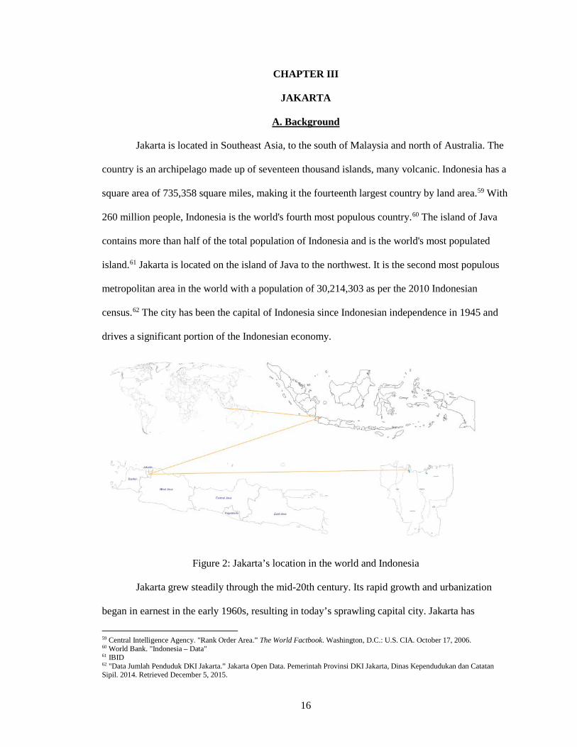
Jakarta is located in Southeast Asia, to the south of Malaysia and north of Australia. The
country is an archipelago made up of seventeen thousand islands, many volcanic. Indonesia has a
square area of 735,358 square miles, making it the fourteenth largest country by land area.59 With
260 million people, Indonesia is the world's fourth most populous country.60 The island of Java
contains more than half of the total population of Indonesia and is the world's most populated
island.61 Jakarta is located on the island of Java to the northwest. It is the second most populous
metropolitan area in the world with a population of 30,214,303 as per the 2010 Indonesian
census.62 The city has been the capital of Indonesia since Indonesian independence in 1945 and
drives a significant portion of the Indonesian economy.
Figure 2: Jakarta’s location in the world and Indonesia
Jakarta grew steadily through the mid-20th century. Its rapid growth and urbanization
began in earnest in the early 1960s, resulting in today’s sprawling capital city. Jakarta has
59 Central Intelligence Agency. "Rank Order Area.” The World Factbook. Washington, D.C.: U.S. CIA. October 17, 2006. 60 World Bank. "Indonesia – Data" 61 IBID 62 "Data Jumlah Penduduk DKI Jakarta.” Jakarta Open Data. Pemerintah Provinsi DKI Jakarta, Dinas Kependudukan dan Catatan Sipil. 2014. Retrieved December 5, 2015.
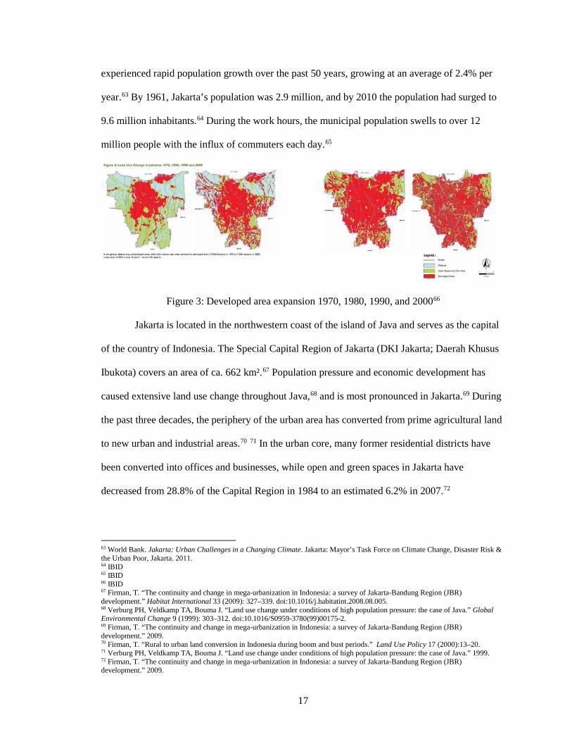
17
experienced rapid population growth over the past 50 years, growing at an average of 2.4% per
year.63 By 1961, Jakarta’s population was 2.9 million, and by 2010 the population had surged to
9.6 million inhabitants.64 During the work hours, the municipal population swells to over 12
million people with the influx of commuters each day.65
Figure 3: Developed area expansion 1970, 1980, 1990, and 200066
Jakarta is located in the northwestern coast of the island of Java and serves as the capital
of the country of Indonesia. The Special Capital Region of Jakarta (DKI Jakarta; Daerah Khusus
Ibukota) covers an area of ca. 662 km².67 Population pressure and economic development has
caused extensive land use change throughout Java,68 and is most pronounced in Jakarta.69 During
the past three decades, the periphery of the urban area has converted from prime agricultural land
to new urban and industrial areas.70 71 In the urban core, many former residential districts have
been converted into offices and businesses, while open and green spaces in Jakarta have
decreased from 28.8% of the Capital Region in 1984 to an estimated 6.2% in 2007.72
63 World Bank. Jakarta: Urban Challenges in a Changing Climate. Jakarta: Mayor’s Task Force on Climate Change, Disaster Risk & the Urban Poor, Jakarta. 2011. 64 IBID 65 IBID 66 IBID 67 Firman, T. “The continuity and change in mega-urbanization in Indonesia: a survey of Jakarta-Bandung Region (JBR) development.” Habitat International 33 (2009): 327–339. doi:10.1016/j.habitatint.2008.08.005. 68 Verburg PH, Veldkamp TA, Bouma J. “Land use change under conditions of high population pressure: the case of Java.” Global Environmental Change 9 (1999): 303–312. doi:10.1016/S0959-3780(99)00175-2. 69 Firman, T. “The continuity and change in mega-urbanization in Indonesia: a survey of Jakarta-Bandung Region (JBR) development.” 2009. 70 Firman, T. “Rural to urban land conversion in Indonesia during boom and bust periods.” Land Use Policy 17 (2000):13–20. 71 Verburg PH, Veldkamp TA, Bouma J. “Land use change under conditions of high population pressure: the case of Java.” 1999. 72 Firman, T. “The continuity and change in mega-urbanization in Indonesia: a survey of Jakarta-Bandung Region (JBR) development.” 2009.
18
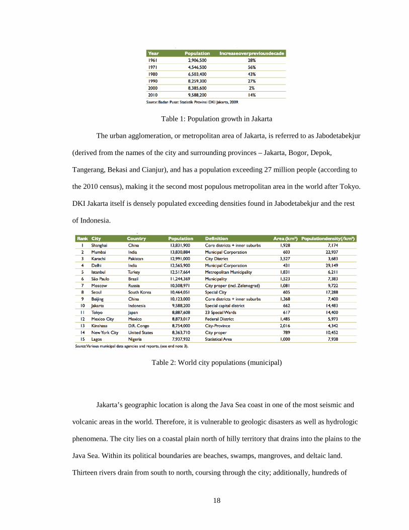
Table 1: Population growth in Jakarta
The urban agglomeration, or metropolitan area of Jakarta, is referred to as Jabodetabekjur
(derived from the names of the city and surrounding provinces – Jakarta, Bogor, Depok,
Tangerang, Bekasi and Cianjur), and has a population exceeding 27 million people (according to
the 2010 census), making it the second most populous metropolitan area in the world after Tokyo.
DKI Jakarta itself is densely populated exceeding densities found in Jabodetabekjur and the rest
of Indonesia.
Table 2: World city populations (municipal)
Jakarta’s geographic location is along the Java Sea coast in one of the most seismic and
volcanic areas in the world. Therefore, it is vulnerable to geologic disasters as well as hydrologic
phenomena. The city lies on a coastal plain north of hilly territory that drains into the plains to the
Java Sea. Within its political boundaries are beaches, swamps, mangroves, and deltaic land.
Thirteen rivers drain from south to north, coursing through the city; additionally, hundreds of
19
man-made drainage canals and tertiary drainage systems have been added with urbanization.
Approximately 40% of Jakarta lies below sea level, and a large portion of this low-lying land is
found in the north of the DKI near the sea.73
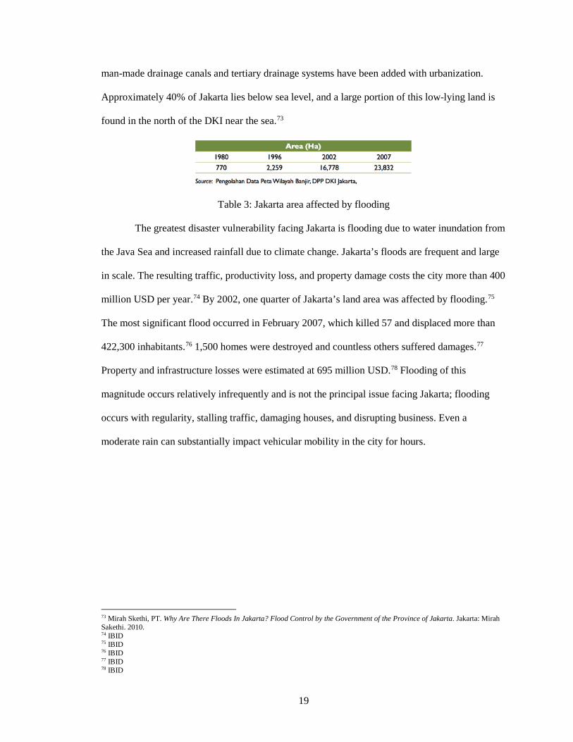
Table 3: Jakarta area affected by flooding
The greatest disaster vulnerability facing Jakarta is flooding due to water inundation from
the Java Sea and increased rainfall due to climate change. Jakarta’s floods are frequent and large
in scale. The resulting traffic, productivity loss, and property damage costs the city more than 400
million USD per year.74 By 2002, one quarter of Jakarta’s land area was affected by flooding.75
The most significant flood occurred in February 2007, which killed 57 and displaced more than
422,300 inhabitants.76 1,500 homes were destroyed and countless others suffered damages.77
Property and infrastructure losses were estimated at 695 million USD.78 Flooding of this
magnitude occurs relatively infrequently and is not the principal issue facing Jakarta; flooding
occurs with regularity, stalling traffic, damaging houses, and disrupting business. Even a
moderate rain can substantially impact vehicular mobility in the city for hours.
73 Mirah Skethi, PT. Why Are There Floods In Jakarta? Flood Control by the Government of the Province of Jakarta. Jakarta: Mirah Sakethi. 2010. 74 IBID 75 IBID 76 IBID 77 IBID 78 IBID
20
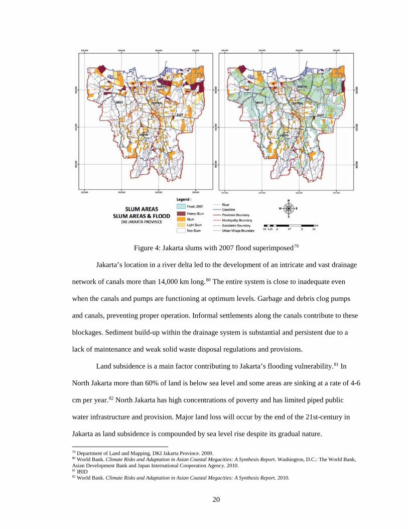
Figure 4: Jakarta slums with 2007 flood superimposed79
Jakarta’s location in a river delta led to the development of an intricate and vast drainage
network of canals more than 14,000 km long.80 The entire system is close to inadequate even
when the canals and pumps are functioning at optimum levels. Garbage and debris clog pumps
and canals, preventing proper operation. Informal settlements along the canals contribute to these
blockages. Sediment build-up within the drainage system is substantial and persistent due to a
lack of maintenance and weak solid waste disposal regulations and provisions.
Land subsidence is a main factor contributing to Jakarta’s flooding vulnerability.81 In
North Jakarta more than 60% of land is below sea level and some areas are sinking at a rate of 4-6
cm per year.82 North Jakarta has high concentrations of poverty and has limited piped public
water infrastructure and provision. Major land loss will occur by the end of the 21st-century in
Jakarta as land subsidence is compounded by sea level rise despite its gradual nature.
79 Department of Land and Mapping, DKI Jakarta Province. 2000. 80 World Bank. Climate Risks and Adaptation in Asian Coastal Megacities: A Synthesis Report. Washington, D.C.: The World Bank, Asian Development Bank and Japan International Cooperation Agency. 2010. 81 IBID 82 World Bank. Climate Risks and Adaptation in Asian Coastal Megacities: A Synthesis Report. 2010.
21
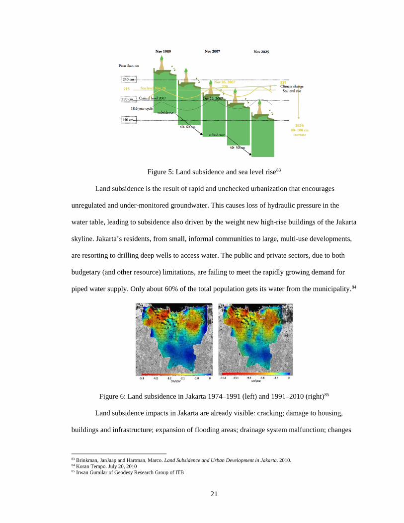
Figure 5: Land subsidence and sea level rise83
Land subsidence is the result of rapid and unchecked urbanization that encourages
unregulated and under-monitored groundwater. This causes loss of hydraulic pressure in the
water table, leading to subsidence also driven by the weight new high-rise buildings of the Jakarta
skyline. Jakarta’s residents, from small, informal communities to large, multi-use developments,
are resorting to drilling deep wells to access water. The public and private sectors, due to both
budgetary (and other resource) limitations, are failing to meet the rapidly growing demand for
piped water supply. Only about 60% of the total population gets its water from the municipality.84
Figure 6: Land subsidence in Jakarta 1974–1991 (left) and 1991–2010 (right)85
Land subsidence impacts in Jakarta are already visible: cracking; damage to housing,
buildings and infrastructure; expansion of flooding areas; drainage system malfunction; changes
83 Brinkman, JanJaap and Hartman, Marco. Land Subsidence and Urban Development in Jakarta. 2010. 84 Koran Tempo. July 20, 2010 85 Irwan Gumilar of Geodesy Research Group of ITB
22
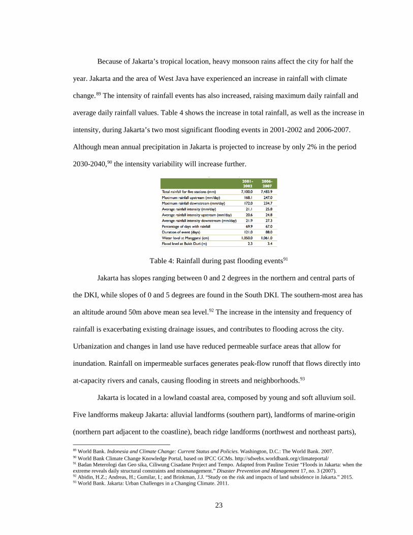
in river canal and drain flow systems; and increased inland sea water intrusion are all evident in
Jakarta, especially to the North. Impacts can be categorized into infrastructural, environmental,
economic and social.86
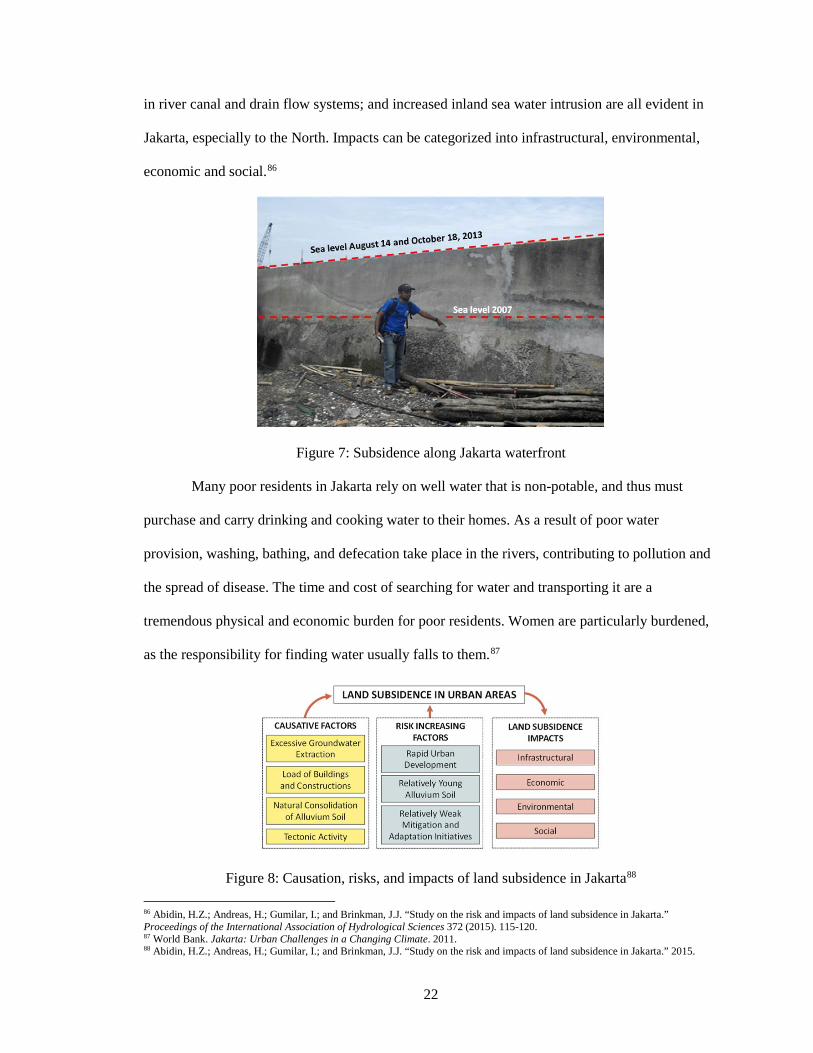
Figure 7: Subsidence along Jakarta waterfront
Many poor residents in Jakarta rely on well water that is non-potable, and thus must
purchase and carry drinking and cooking water to their homes. As a result of poor water
provision, washing, bathing, and defecation take place in the rivers, contributing to pollution and
the spread of disease. The time and cost of searching for water and transporting it are a
tremendous physical and economic burden for poor residents. Women are particularly burdened,
as the responsibility for finding water usually falls to them.87
Figure 8: Causation, risks, and impacts of land subsidence in Jakarta88 86 Abidin, H.Z.; Andreas, H.; Gumilar, I.; and Brinkman, J.J. “Study on the risk and impacts of land subsidence in Jakarta.” Proceedings of the International Association of Hydrological Sciences 372 (2015). 115-120. 87 World Bank. Jakarta: Urban Challenges in a Changing Climate. 2011. 88 Abidin, H.Z.; Andreas, H.; Gumilar, I.; and Brinkman, J.J. “Study on the risk and impacts of land subsidence in Jakarta.” 2015.
23
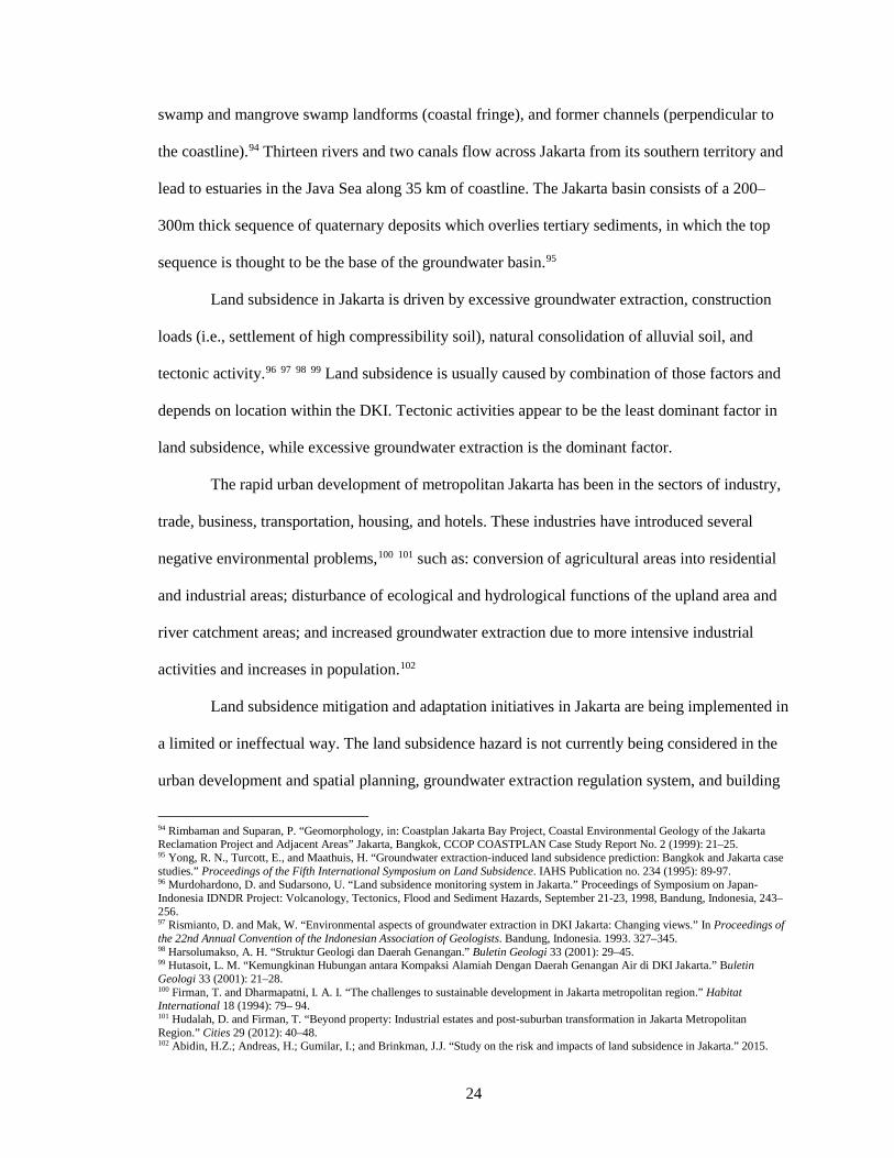
Because of Jakarta’s tropical location, heavy monsoon rains affect the city for half the
year. Jakarta and the area of West Java have experienced an increase in rainfall with climate
change.89 The intensity of rainfall events has also increased, raising maximum daily rainfall and
average daily rainfall values. Table 4 shows the increase in total rainfall, as well as the increase in
intensity, during Jakarta’s two most significant flooding events in 2001-2002 and 2006-2007.
Although mean annual precipitation in Jakarta is projected to increase by only 2% in the period
2030-2040,90 the intensity variability will increase further.
Table 4: Rainfall during past flooding events91
Jakarta has slopes ranging between 0 and 2 degrees in the northern and central parts of
the DKI, while slopes of 0 and 5 degrees are found in the South DKI. The southern-most area has
an altitude around 50m above mean sea level.92 The increase in the intensity and frequency of
rainfall is exacerbating existing drainage issues, and contributes to flooding across the city.
Urbanization and changes in land use have reduced permeable surface areas that allow for
inundation. Rainfall on impermeable surfaces generates peak-flow runoff that flows directly into
at-capacity rivers and canals, causing flooding in streets and neighborhoods.93
Jakarta is located in a lowland coastal area, composed by young and soft alluvium soil.
Five landforms makeup Jakarta: alluvial landforms (southern part), landforms of marine-origin
(northern part adjacent to the coastline), beach ridge landforms (northwest and northeast parts),
89 World Bank. Indonesia and Climate Change: Current Status and Policies. Washington, D.C.: The World Bank. 2007. 90 World Bank Climate Change Knowledge Portal, based on IPCC GCMs. http://sdwebx.worldbank.org/climateportal/ 91 Badan Meterologi dan Geo sika, Ciliwung Cisadane Project and Tempo. Adapted from Pauline Texier “Floods in Jakarta: when the extreme reveals daily structural constraints and mismanagement.” Disaster Prevention and Management 17, no. 3 (2007). 92 Abidin, H.Z.; Andreas, H.; Gumilar, I.; and Brinkman, J.J. “Study on the risk and impacts of land subsidence in Jakarta.” 2015. 93 World Bank. Jakarta: Urban Challenges in a Changing Climate. 2011.
24
swamp and mangrove swamp landforms (coastal fringe), and former channels (perpendicular to
the coastline).94 Thirteen rivers and two canals flow across Jakarta from its southern territory and
lead to estuaries in the Java Sea along 35 km of coastline. The Jakarta basin consists of a 200–
300m thick sequence of quaternary deposits which overlies tertiary sediments, in which the top
sequence is thought to be the base of the groundwater basin.95
Land subsidence in Jakarta is driven by excessive groundwater extraction, construction
loads (i.e., settlement of high compressibility soil), natural consolidation of alluvial soil, and
tectonic activity.96 97 98 99 Land subsidence is usually caused by combination of those factors and
depends on location within the DKI. Tectonic activities appear to be the least dominant factor in
land subsidence, while excessive groundwater extraction is the dominant factor.
The rapid urban development of metropolitan Jakarta has been in the sectors of industry,
trade, business, transportation, housing, and hotels. These industries have introduced several
negative environmental problems,100 101 such as: conversion of agricultural areas into residential
and industrial areas; disturbance of ecological and hydrological functions of the upland area and
river catchment areas; and increased groundwater extraction due to more intensive industrial
activities and increases in population.102
Land subsidence mitigation and adaptation initiatives in Jakarta are being implemented in
a limited or ineffectual way. The land subsidence hazard is not currently being considered in the
urban development and spatial planning, groundwater extraction regulation system, and building
94 Rimbaman and Suparan, P. “Geomorphology, in: Coastplan Jakarta Bay Project, Coastal Environmental Geology of the Jakarta Reclamation Project and Adjacent Areas” Jakarta, Bangkok, CCOP COASTPLAN Case Study Report No. 2 (1999): 21–25. 95 Yong, R. N., Turcott, E., and Maathuis, H. “Groundwater extraction-induced land subsidence prediction: Bangkok and Jakarta case studies.” Proceedings of the Fifth International Symposium on Land Subsidence. IAHS Publication no. 234 (1995): 89-97. 96 Murdohardono, D. and Sudarsono, U. “Land subsidence monitoring system in Jakarta.” Proceedings of Symposium on Japan- Indonesia IDNDR Project: Volcanology, Tectonics, Flood and Sediment Hazards, September 21-23, 1998, Bandung, Indonesia, 243–256. 97 Rismianto, D. and Mak, W. “Environmental aspects of groundwater extraction in DKI Jakarta: Changing views.” In Proceedings of the 22nd Annual Convention of the Indonesian Association of Geologists. Bandung, Indonesia. 1993. 327–345. 98 Harsolumakso, A. H. “Struktur Geologi dan Daerah Genangan.” Buletin Geologi 33 (2001): 29–45. 99 Hutasoit, L. M. “Kemungkinan Hubungan antara Kompaksi Alamiah Dengan Daerah Genangan Air di DKI Jakarta.” Buletin Geologi 33 (2001): 21–28. 100 Firman, T. and Dharmapatni, I. A. I. “The challenges to sustainable development in Jakarta metropolitan region.” Habitat International 18 (1994): 79– 94. 101 Hudalah, D. and Firman, T. “Beyond property: Industrial estates and post-suburban transformation in Jakarta Metropolitan Region.” Cities 29 (2012): 40–48. 102 Abidin, H.Z.; Andreas, H.; Gumilar, I.; and Brinkman, J.J. “Study on the risk and impacts of land subsidence in Jakarta.” 2015.

25
codes of Jakarta. Although regulations have been introduced to limit groundwater extraction
subsidence prone areas of Jakarta, enforcement is lacking.103
The potential losses due to land subsidence in Jakarta are significant.104 105
Infrastructural, social, and environmental costs due to direct, and indirect, impacts of land
subsidence are economically significant and should not be underestimated for sustainable urban
development. The planning, development, and maintenance costs of building and maintaining
infrastructure in affected areas are much higher than in normal circumstances. Collateral impacts
of coastal subsidence in Jakarta causing coastal flooding during high tides that are quite
damaging.106 Repeated coastal flooding in several areas along the coast will deteriorate the
structure and function of buildings and infrastructure, as well as contribute to reductions in the
quality of life, environment, health, economy, and social activities.
Rising sea level is a long-term climate change challenge for Jakarta. Figure 10 illustrates
the anticipated rise in global sea level until the year 2100 from thermal expansion of the oceans,
and melting of polar ice caps and glaciers. Climate change is also expected to increase the
frequency and severity of climatic extremes such as storm surges and violent tides.107 North
Jakarta, which borders the Java Sea and is home to a wide range of income levels, businesses,
industry, and the port, is especially susceptible.
103Abidin, H.Z.; Andreas, H.; Gumilar, I.; and Brinkman, J.J. “Study on the risk and impacts of land subsidence in Jakarta.” 2015. 104 Ward, P. J., Marfai, M. A., Yulianto, F., Hizbaron, D. R., and Aerts, J. C. J. H. “Coastal inundation and damage exposure estimation: a case study for Jakarta.” Natural Hazards 56 (2011): 899–916. 105 Viets, V. F. “Environmental and Economic Effects of Subsidence.” Publication of Lawrence Berkeley National Laboratory, LBNL Paper LBL-8615. 2010. 106 Abidin, H. Z., Andreas, H., Gumilar, I., Fukuda, Y., Pohan, Y. E., and Deguchi, T. “Land subsidence of Jakarta (Indonesia) and its relation with urban development.” Natural Hazards 59 (2011): 1753–1771. 107 Yusuf, Arief Anshory and Francisco, Herminia. Climate Change Vulnerability Mapping for Southeast Asia. Singapore: Economy and Environment Program for Southeast Asia. 2009.
26
Figure 9: Rainfall during past flooding events108
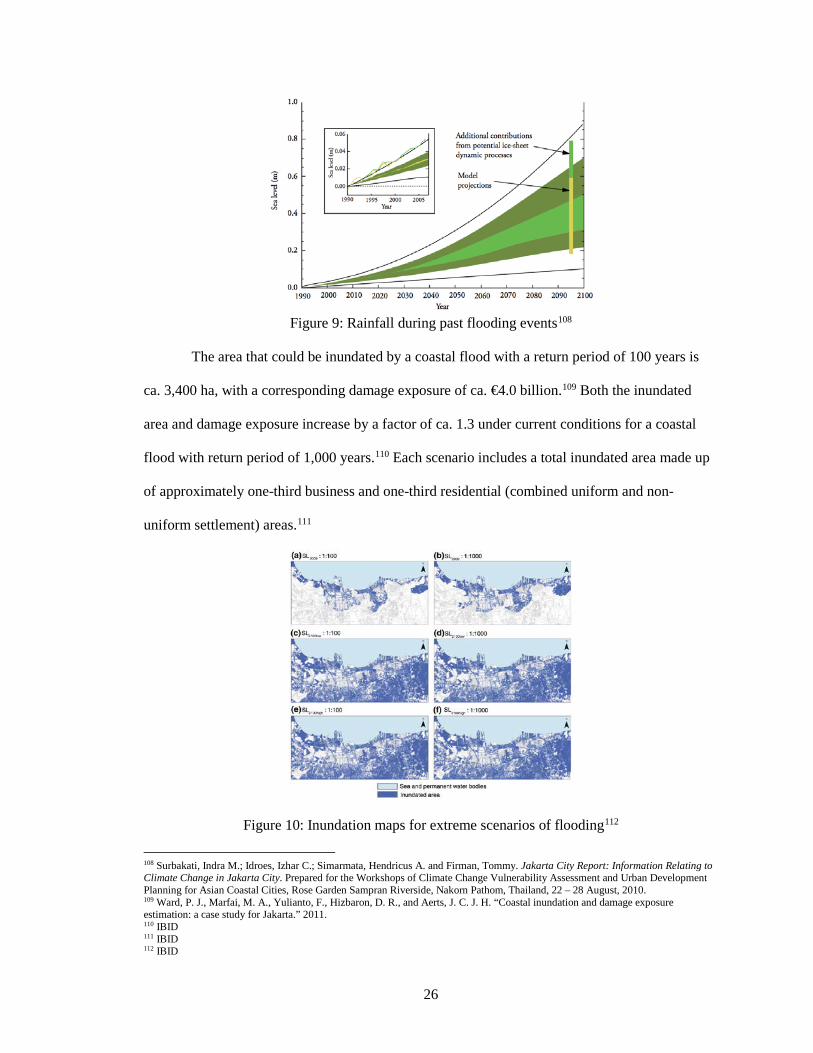
The area that could be inundated by a coastal flood with a return period of 100 years is
ca. 3,400 ha, with a corresponding damage exposure of ca. €4.0 billion.109 Both the inundated
area and damage exposure increase by a factor of ca. 1.3 under current conditions for a coastal
flood with return period of 1,000 years.110 Each scenario includes a total inundated area made up
of approximately one-third business and one-third residential (combined uniform and non-
uniform settlement) areas.111
Figure 10: Inundation maps for extreme scenarios of flooding112
108 Surbakati, Indra M.; Idroes, Izhar C.; Simarmata, Hendricus A. and Firman, Tommy. Jakarta City Report: Information Relating to Climate Change in Jakarta City. Prepared for the Workshops of Climate Change Vulnerability Assessment and Urban Development Planning for Asian Coastal Cities, Rose Garden Sampran Riverside, Nakorn Pathom, Thailand, 22 – 28 August, 2010. 109 Ward, P. J., Marfai, M. A., Yulianto, F., Hizbaron, D. R., and Aerts, J. C. J. H. “Coastal inundation and damage exposure estimation: a case study for Jakarta.” 2011. 110 IBID 111 IBID 112 IBID
27
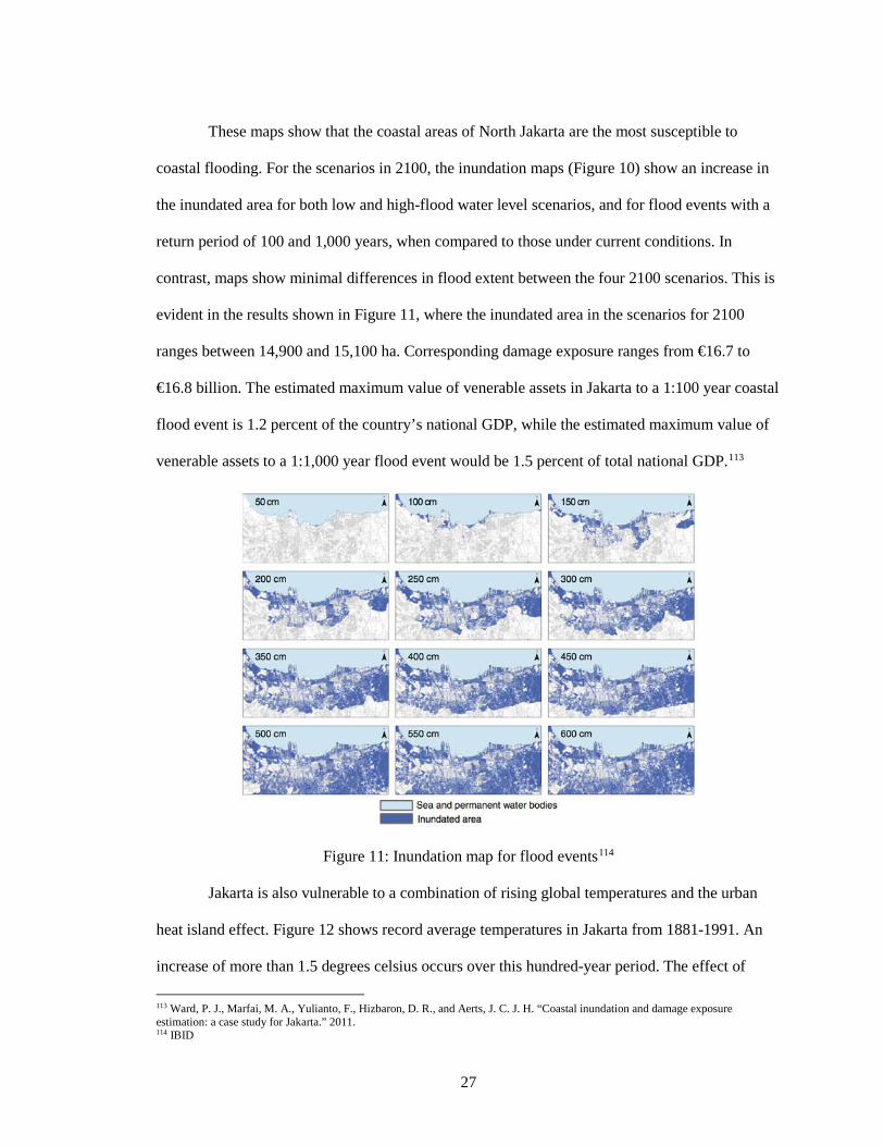
These maps show that the coastal areas of North Jakarta are the most susceptible to
coastal flooding. For the scenarios in 2100, the inundation maps (Figure 10) show an increase in
the inundated area for both low and high-flood water level scenarios, and for flood events with a
return period of 100 and 1,000 years, when compared to those under current conditions. In
contrast, maps show minimal differences in flood extent between the four 2100 scenarios. This is
evident in the results shown in Figure 11, where the inundated area in the scenarios for 2100
ranges between 14,900 and 15,100 ha. Corresponding damage exposure ranges from €16.7 to
€16.8 billion. The estimated maximum value of venerable assets in Jakarta to a 1:100 year coastal
flood event is 1.2 percent of the country’s national GDP, while the estimated maximum value of
venerable assets to a 1:1,000 year flood event would be 1.5 percent of total national GDP.113
Figure 11: Inundation map for flood events114
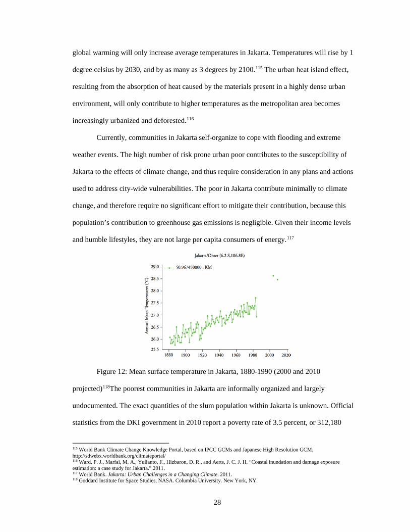
Jakarta is also vulnerable to a combination of rising global temperatures and the urban
heat island effect. Figure 12 shows record average temperatures in Jakarta from 1881-1991. An
increase of more than 1.5 degrees celsius occurs over this hundred-year period. The effect of
113 Ward, P. J., Marfai, M. A., Yulianto, F., Hizbaron, D. R., and Aerts, J. C. J. H. “Coastal inundation and damage exposure estimation: a case study for Jakarta.” 2011. 114 IBID
28
global warming will only increase average temperatures in Jakarta. Temperatures will rise by 1
degree celsius by 2030, and by as many as 3 degrees by 2100.115 The urban heat island effect,
resulting from the absorption of heat caused by the materials present in a highly dense urban
environment, will only contribute to higher temperatures as the metropolitan area becomes
increasingly urbanized and deforested.116
Currently, communities in Jakarta self-organize to cope with flooding and extreme
weather events. The high number of risk prone urban poor contributes to the susceptibility of
Jakarta to the effects of climate change, and thus require consideration in any plans and actions
used to address city-wide vulnerabilities. The poor in Jakarta contribute minimally to climate
change, and therefore require no significant effort to mitigate their contribution, because this
population’s contribution to greenhouse gas emissions is negligible. Given their income levels
and humble lifestyles, they are not large per capita consumers of energy.117
Figure 12: Mean surface temperature in Jakarta, 1880-1990 (2000 and 2010
projected)118The poorest communities in Jakarta are informally organized and largely
undocumented. The exact quantities of the slum population within Jakarta is unknown. Official
statistics from the DKI government in 2010 report a poverty rate of 3.5 percent, or 312,180
115 World Bank Climate Change Knowledge Portal, based on IPCC GCMs and Japanese High Resolution GCM. http://sdwebx.worldbank.org/climateportal/ 116 Ward, P. J., Marfai, M. A., Yulianto, F., Hizbaron, D. R., and Aerts, J. C. J. H. “Coastal inundation and damage exposure estimation: a case study for Jakarta.” 2011. 117 World Bank. Jakarta: Urban Challenges in a Changing Climate. 2011. 118 Goddard Institute for Space Studies, NASA. Columbia University. New York, NY.
29
people, based on a poverty line of per capita monthly income of IDR 331,169 (about 1.23 USD
per day at current exchange rates).119 While this percentage is lower than many rural and other
urban areas in Indonesia, it includes a significant number of people and households in Jakarta due
to its size and scale. If one were to raise the threshold of poverty, this number would rise
dramatically.
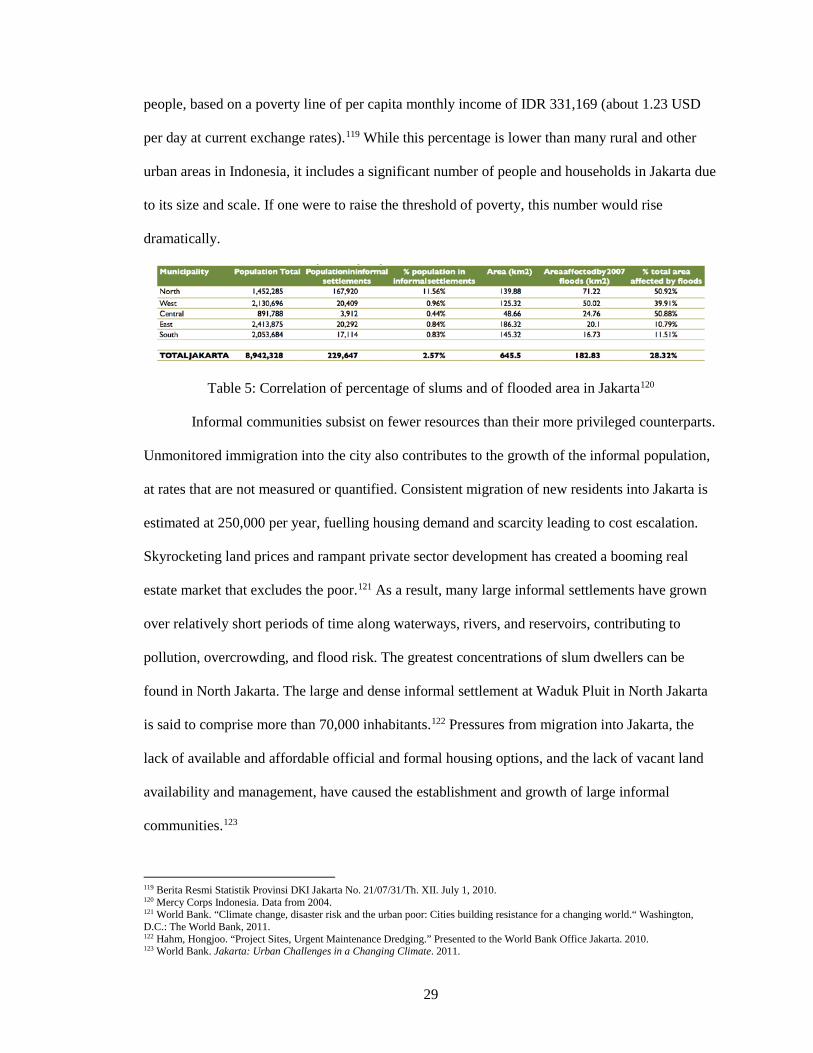
Table 5: Correlation of percentage of slums and of flooded area in Jakarta120
Informal communities subsist on fewer resources than their more privileged counterparts.
Unmonitored immigration into the city also contributes to the growth of the informal population,
at rates that are not measured or quantified. Consistent migration of new residents into Jakarta is
estimated at 250,000 per year, fuelling housing demand and scarcity leading to cost escalation.
Skyrocketing land prices and rampant private sector development has created a booming real
estate market that excludes the poor.121 As a result, many large informal settlements have grown
over relatively short periods of time along waterways, rivers, and reservoirs, contributing to
pollution, overcrowding, and flood risk. The greatest concentrations of slum dwellers can be
found in North Jakarta. The large and dense informal settlement at Waduk Pluit in North Jakarta
is said to comprise more than 70,000 inhabitants.122 Pressures from migration into Jakarta, the
lack of available and affordable official and formal housing options, and the lack of vacant land
availability and management, have caused the establishment and growth of large informal
communities.123
119 Berita Resmi Statistik Provinsi DKI Jakarta No. 21/07/31/Th. XII. July 1, 2010. 120 Mercy Corps Indonesia. Data from 2004. 121 World Bank. “Climate change, disaster risk and the urban poor: Cities building resistance for a changing world.“ Washington, D.C.: The World Bank, 2011. 122 Hahm, Hongjoo. “Project Sites, Urgent Maintenance Dredging.” Presented to the World Bank Office Jakarta. 2010. 123 World Bank. Jakarta: Urban Challenges in a Changing Climate. 2011.
30
The poorest communities in Jakarta live in self-constructed informal dwellings, usually
on land without legal title, and subsist on informal jobs in the informal economy. Jakarta has a
long history of large informal settlements, featuring areas where individuals and households have
lived in what are considered “slums” for decades. While individuals may have homes and
livelihoods that are risk prone and difficult to quantify, there are well established social networks
and cultural identities found within each of Jakarta’s slums. The informal social and economic
networks are one of the most adaptive and resilient strengths of Jakarta’s urban poor.
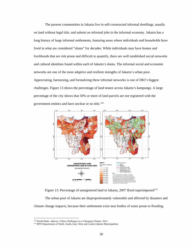
Appreciating, harnessing, and formalizing these informal networks is one of DKI’s biggest
challenges. Figure 13 shows the percentage of land tenure across Jakarta’s kampungs. A large
percentage of the city shows that 50% or more of land parcels are not registered with the
government entities and have unclear or no title.124
Figure 13: Percentage of unregistered land in Jakarta, 2007 flood superimposed125
The urban poor of Jakarta are disproportionately vulnerable and affected by disasters and
climate change impacts, because their settlements exist near bodies of water prone to flooding.
124 World Bank. Jakarta: Urban Challenges in a Changing Climate. 2011. 125 BPN Departments of North, South, East, West and Central Jakarta Municipalities
31
This exposes residents to flooding and related hazards caused by rain and tidal floods (locally
known as “rob”). These hazards, when combined with the economic and physical fragility of low-
income residents, exposes them to property loss, illness, economic supression, social disruption,
and physical displacement. Most of these high-risk areas were intended to remain vacant, but
weak enforcement by local government, and informal subletting and divisions within the private
sector have promoted growth.126
The urban poor of Jakarta are vulnerable to health risks and property loss because of
where they live. Many also experience socio-economic vulnerabilities because their livelihoods
are tied to risk areas as well. The ability of the urban poor to adapt is limited due to a lack of
access to basic services like potable water, healthcare, and education. North Jakarta experiences
the highest rates and concentrations of poverty in flooding areas. The communities of Kampung
Melayu and Bukit Duri experience regular neighborhood wide evacuations due to flood events.
Coastal communal wells experience saline intrusion, as well as inland garbage and sewage flow
into these communities, leading to the spread of illness stemming from unsanitary conditions.127
Weak government regulation of settlement and development are compounded by the lack
of basic services including housing, clean water and garbage collection. Informal physical
structures spill into waterways and block the already limited drainage capacity of canals and
rivers, leading to major issues and poor performance within the at-capacity system. Communities
utilize the rivers for disposal of their solid waste,refuse, and human waste, because disposal
options are inadequate or non-existent throughout most of Jakarta. There is currently no citywide
solid waste management plan or disposal method for Jakarta. Waste collection is dealt with by
private companies, with wealthier areas paying more to receive better service. In many areas,
waste is collected and picked over by an efficient, but informal, waste picker and recycling
community.128
126 World Bank. Jakarta: Urban Challenges in a Changing Climate. 2011. 127 IBID 128 World Bank. “Climate change, disaster risk and the urban poor: Cities building resistance for a changing world.“ 2011.
32
Consideration of the urban poor is essential when addressing issues of risk vulnerability
in Jakarta, especially when dealing with government implementation of city-wide spatial planning
initiatives and flood alleviation interventions.129 Housing, land use, and zoning laws exist, but are
mostly unenforced, aiding the development of informal settlements. Although laws and building
code require easements of ten to fifteen meters along waterways, these zones are where informal
settlements settle and flourish. Eviction policies and demolition have been a main strategy for
managing informal settlements, not without protests from NGOs, community organizations, and
other civil rights groups. When implemented, communities and households are moved into
apartment blocks in the relative vicinity of their informal settlements at very low costs, many do
not remain, however. Within a few years, informal housing reappears along the under regulated
cleared easements along the waterways, and are settled by new immigrants or returning
residents.130 When rapid resettlement occurs it oftentimes includes previous residents returning to
the neighborhood, but can also indicate scarce or expensive land, inadequate public housing, a
lack of government policies to deal with migrants, as well as the desirability of a given slum’s
location.
The residents of Jakarta’s informal settlements contribute to a large informal economy,
and support the functioning of the formal economy. While quantifying its contribution is difficult,
up to 38% of Jakarta’s economy is considered informal. In most areas, residents of informal
settlements work as maids, janitors, security guards, and parking attendants, or run small local
businesses like food stalls and retail kiosks.131 Coastal settlements employ fishermen and provide
larger and small businesses with fish to sell across the city.132
Mitigation and adaptation programs, projects, and actions have been implemented at all
scales in Jakarta. These measures rely on large scale projects and initiatives, leaving individuals
and communities responsible for site specific adaptations. Individual measures include moving to 129 World Bank. Jakarta: Urban Challenges in a Changing Climate. 2011. 130 United Nations Settlements Programme. Housing Finance Mechanisms in Indonesia. Nairobi: United Nations, 2008. 131 World Bank. Jakarta: Urban Challenges in a Changing Climate. 2011. 132 IBID
33
the second story to avoid frequent flood events, reconstruction of housing on stilts to avoid
flooded terrain, as well as community driven dredging and waste collection to reduce the impacts
of stormwater runoff and flooding due to sedimentation. Recent NGO projects relating to climate
change adaptation and the urban poor indicate a lack of program interest and investment in
understanding how low-income communities are adapting, as well as how the government can
support them locally. A mismatch exists between the sustainability of adaptation measures, and
the magnitude of possible future disasters.133 Successful provision and management of services
by the government lags in most cases. In spite of a rapidly expanding economy, private sector
property development, spatial planning and infrastructure, as well as service distribution and
provision (transportation, green space, affordable housing, clean water, healthcare, and education)
have not kept up with demand.134
B. Jakarta Slum/Informal Conditions
Most of Jakarta's urban poor cannot afford to buy housing provided by the State Housing
Provider Agency (PERUMNAS) or private developers. This has forced them to seek individual
solutions that include self-built housing units and squatter settlements that eventually lead to slum
establishment and growth.135136
Most poor residents of Jakarta live in spontaneous informal settlements called kampungs.
These are scattered throughout the city and consistently have substandard infrastructure, small
plots, and low quality buildings. Most dwellings in kampungs are constructed incrementally by
residents from permanent and non-permanent materials, based largely on what they can afford.137
133 World Bank. Jakarta: Urban Challenges in a Changing Climate. 2011. 134 World Bank. “Climate change, disaster risk and the urban poor: Cities building resistance for a changing world.“ 2011. 135 Sudarmo, Sri Probo. “Recent Development in Indonesian Urban Development Strategy.” In The Challenge of Sustainable Cities: Neoliberalism and Urban Strategies in Developing Countries, Eds. Rod Burgess, Marisa Carmona and Theo Kolstee. London: Zed Books. 1997. 136Tunas, Devisari and Peresthu, Andrea. “The Self-help Housing in Indonesia: The Only Option for the Poor?” Habitat International 34 (2010): 315-322. 137 Tunas and Peresthu. “The Self-help Housing in Indonesia: The Only Option for the Poor?” 2010.
34
Kampung residents occupy state land such as disposal sites, riverbanks, and railway tracks, and
private unoccupied land, where they illegally construct their dwellings.138
Indonesia has initiated three types of housing policies: self-help housing policy such as
the Kampung Improvement Program (KIP), Community-based Housing Development (P2BPK),
and Self-help Housing Assistance (BSPS). PERUMNAS is the national program for public
housing development.139 According to the National Indonesian Socioeconomic Survey
(SUSENAS), the dominant type of new housing in Indonesia is self-built, which accounts for
more than 70 percent of new housing produced between 2002 and 2007.140 141 Its prevalence in
Indonesia is due to the informal housing sector.142 143 144 The informal housing sector takes place
mostly in Indonesian kampungs.145 146 A kampung is an unplanned, incrementally developed area
frequently associated with slums.147 Informal and self-built housing in these kampungs constitutes
the majority of new housing construction in Indonesia.148
In order to address the issues found within Kampungs, KIP upgraded roads and footpaths,
improved drainage, water supply, sanitation, and solid waste disposal; and also supported the
construction of new schools and health clinics 149 150 In the 1980s, KIP was redesigned to work in
the Community Infrastructure Program as part of the Integrated Urban Infrastructure
Development Programme (IUIDP). KIP was redesigned to include the coordinated improvement
138 Winayanti, Lana and Lang, Heracles C. “Provision of urban services in an informal settlement: a case study of Kampung Penas Tanggul, Jakarta.” Habitat International 28, no. 1 (2004): 41-65. 139 Tunas and Peresthu. “The Self-help Housing in Indonesia: The Only Option for the Poor?” 2010. 140 Monkkonen, Paavo. “Housing deficits as a frame for housing policy: demographic change, economic crisis and household information in Indonesia.” International Journal of Housing Policy 13, no. 3 (2013 a): 247-267. 141 Mungkasa, Oswar. “Catatan Kritis tentang Hunian Berimbang.” HUD Magazine 4 (2013): 18-21. 142 Crane, Randall; Daniere, Amrita; and Harwood, Stacy. “The contribution of environmental amenities to low-income housing: a comparative study of Bangkok and Jakarta.” Urban Studies 34 (1997): 1495-1500. 143Leaf, M. “Land rights for residential development in Jakarta: the colonial roots of contemporary urban dualism.” International Journal of Urban and Regional Research 17 (1993): 477-491. 144Struyk, R.J.; Hoffman, M.L. and Katsura, H.M. The market for shelter in Indonesian Cities. Washington, D.C.: The Urban Institute. 1990. 145 Leaf. Land rights for residential development in Jakarta: the colonial roots of contemporary urban dualism. 146 Tunas and Peresthu. “The Self-help Housing in Indonesia: The Only Option for the Poor?” 2010. 147 Winarso, Haryo. “Urban dualism in the Jakarta Metropolitan Area.” In Megacities: Urban Form, Governance and Sustainability. Eds. A. Sorensen and J. Okata. New York: Springer. 2010. pp. 163-190. 148 Monkkonen, Paavo. “Housing deficits as a frame for housing policy: demographic change, economic crisis and household information in Indonesia.” 2013a. 149 Garr, Daniel. “Indonesia’s Kampung Improvement Program: Policy Issues and Local Impacts for Secondary Cities.” Journal of Planning Education and Research 9, no. 1 (1989): 79–83. 150 Tunas and Peresthu. “The Self-help Housing in Indonesia: The Only Option for the Poor?” 2010.
35
of physical quality (Bina Lingkungan), the improvement of quality of life (Bina Manusia), and
the improvement of the economy (Bina Usaha).151 152
The community-based housing development or Pembangunan Perumahan Bertumpu pada
Komunitas (P2BPK), is a housing program that facilitates informal and community-based
housing delivery and construction. It encourages communities to mobilize resources to lower
housing costs.153
The Ministry of Public Housing created the Self-help Housing Assistance (BSPS) in 2006
to address and support low-income households in urban and rural Indonesia. BSPS seeks to
develop new housing, improve home quality, and develop public infrastructure and utilities. They
do this by providing cash, construction tools, and materials. BSPS recipients must live below the
poverty line, be married, have title to land, and have a bank account. The number of built or
improved housing units and and other projects increased from 3,550 in 2006 to 16,403 units in
2011.154
Informal and self-help housing has become an essential and integral part of the urban
landscape in Indonesia. These informal settlements accommodate millions of urban poor who
otherwise lack access to affordable or public housing.155 Indonesian kampungs house most of the
urban poor in Indonesia and suffer from extreme density, poor quality of life, and lack
appropriate infrastructure and public facilities.156 157
C. KIP Slum upgrading
The Kampung Improvement Project (KIP) was launched in 1969 by the Governor of
Jakarta, in an effort to upgrade the living conditions within Jakarta’s kampungs. KIP was the first
151 Tunas and Peresthu. “The Self-help Housing in Indonesia: The Only Option for the Poor?” 2010. 152 Silver, Christopher. Planning the Megacity: Jakarta in the Twentieth Century. New York: Routledge. 2008. 153 Rukmana, Deden. “The Megacity of Jakarta: Problems, Challenges and Planning Efforts.” Indonesia’s Urban Studies. Last modified March 29, 2014. http://indonesiaurbanstudies.blogspot.com/2014/03/the-megacity-of-jakarta-problems.html 154 IBID 155 Tunas and Peresthu. “The Self-help Housing in Indonesia: The Only Option for the Poor?” 2010. 156 IBID 157 Winayanti, Lana and Lang, Heracles C. “Provision of urban services in an informal settlement: a case study of Kampung Penas Tanggul, Jakarta.” 2004.
36
slum upgrading project in the world, and was funded by the World Bank until 1982.158 The
program aimed to retain and improve existing housing stock and to provide services to sites for
the construction of new housing, utilizing self-build and self-help methods.159
The urban population of Indonesia spiked from 22.6 million in 1970 to 32.8 million in
1980, to 55.4 million in 1990.160 By 1995, Indonesia's total population was estimated at 175
million, 28 percent of whom live in urban areas.161 An annual urban growth rate of four percent
meant that the country's urban population rose to 36 percent of the entire population of the
country by 2000.162
Over the past three decades, the World Bank closely observed this rapid urbanization.
The first generation of World Bank-financed projects included Urban I, Urban II, Urban III, and
Urban IV.163 The primary component of these projects was the Kampung Improvement Program
(KIP). KIP funding ranged from 70 percent in Urban I to 32.8 percent in Urban IV.164
Components of the four projects included solid waste management, drainage, community health
service, land registration, and technical assistance and training provision and improvement. KIP
sought to alleviate poverty with support for efforts focused on improving housing services and
basic infrastructure in low-income areas. Although implemented in 1974 and the following
decades, Urban I-IV addressed problems that still affect Indonesia's cities today: inadequate
infrastructure and deteriorating environmental conditions.165
KIP Urban I-IV projects facilitated housing and environmental improvements for low-
income urban households in Indonesia and Jakarta at a low cost (ranging from 118 USD per
person in Jakarta to 23 USD in smaller cities, using 1993 US dollars). KIP improvements in non-
158 Juliman, D. “The world’s first slum upgrading programme.” Presented at the World Urban Forum III in Vancouver, BC, June 19-23, 2006. 159 Silver, Christopher. Planning the Megacity: Jakarta in the Twentieth Century. 2008. 160 World Bank. Indonesia Impact Evaluation Report: Enhancing quality of Life in Urban Indonesia: The Legacy of Kampung Improvement Program. Washington, D.C.: The World Bank, 1995. 161 IBID 162 IBID 163 IBID 164 IBID 165 World Bank. Indonesia Impact Evaluation Report: Enhancing quality of Life in Urban Indonesia: The Legacy of Kampung Improvement Program. 1995.
37
KIP kampungs have caught up with those in upgraded kampungs due to favorable economic
development. Evidence exists, however, showing that improvements to non-KIP kampungs were
completed at a slower speed when compared to the rapid changes KIP had on the kampungs
where it was implemented.166
The most positive result of KIP was improvement of the quality of life for kampung
residents. This was realized through improved footpaths, lighting, education and health facilities,
living space and reduction of housing density. KIP provided broader access to potable water,
private toilets/septic tanks, and less frequent flood events. More than two thirds of respondents in
project areas associated improvements in their kampung to KIP.167 Most respondents also
indicated overall environmental conditions in their neighborhood had improved since KIP
implementation, however, one-third of respondents were not fully satisfied. Garbage collection
(both frequency and quality), was cited as a persistent problem.168
Throughout Jakarta, environmental conditions have deteriorated as rapid population and
economic growth resulted in increased demand for urban infrastructure. Despite KIP Urban I-IV
improvements, the environment in Jakarta continues to deteriorate, fueled by population growth.
The urban environmental challenge today is more substantial than during Urban I-IV
implementation. Further actions should be taken to balance urban growth and environmental
conditions. At kampung and city-wide levels, KIP did not anticipate future environmental
problems, ranging from increased traffic congestion to air pollution. While the design standards
of KIP increased access to fire-fighting units, the use of flammable building materials and
overcrowding simultaneously increased fire risk.169
Indonesian cities are rapidly growing, meaning some kampungs have become valuable
urban real estate. Rising demand for well located real estate have driven kampungs into the
166 World Bank. Indonesia Impact Evaluation Report: Enhancing quality of Life in Urban Indonesia: The Legacy of Kampung Improvement Program. 1995. 167 IBID 168 IBID 169 IBID
38
private land and real estate market. Do kampung residents benefit from investment? Have Urban
I-IV projects failed when demolition occurs? Residents did benefit, but could have gained more
value had their property rights been secured. The study also found that KIP investments could see
returns of twelve percent even outside the five-year term period.170 Some of the Urban I-IV
impacts have since been demolished within improved kampungs to make space for market rate
urban development. The rising demand and scarcity of urban land within the Indonesian real
estate sector will lead to many situations where improved kampungs are demolished for
conversion into commercial and upmarket residential real estate.171
KIP did not lead to an influx of higher-income groups (gentrification) into kampungs.
KIP did not disturb the residential stability of the kampungs, even as the social profile of the
kampungs has improved. Residents are better educated and healthier; household sizes have
declined; residents are employed and have greater income; and women play a more significant
role in meeting economic needs of their families.172
KIP serves as a starting point for the upgrade and formalization of Jakarta’s plentiful
slums. The simple and somewhat rudimentary upgrades it provided helped improve the living
conditions of vast swathes of Jakarta. KIP, however, failed to address many aspects of the
informal architecture present in Jakarta’s slums, meaning individuals were not direct beneficiaries
of KIP improvements. Cooperation with institutional, government, and planning policies became
a component of later stages of KIP, highlighting physical improvements cannot be the sole
remedy for slum improvement.
170 World Bank. Indonesia Impact Evaluation Report: Enhancing quality of Life in Urban Indonesia: The Legacy of Kampung Improvement Program. 1995. 171 IBID 172 IBID
39
CHAPTER IV
INCREMENTALISM IN ACTION
A. Underlying Concepts The following chapter focuses on theories and case studies important to my
understanding of incrementalism. The theories I present are not directly linked to incrementalism,
but feature guides to the creation of resilient housing, architecture as impermanent and
changeable entities, self build methods, resource utilization and social empowerment aims. Each
theory played an important role in all stages of design for my project.
The chapter also highlights case studies that provide lessons, problems, and solutions that
various approaches to incrementalism can entail. The case studies I have focused on do not
outright link themselves to incrementalism, but feature many aspect, condition, and typological
links to the movement. Some case studies serve as anti-precedents, while others highlight positive
and negative aspects of their approach to incrementalism.
1. How Buildings Learn
In How Buildings Learn, Stewart Brand discusses the changes in use, form, program, and
technology that buildings experience over time. Brand examines how more time and money is
spent retrofitting existing buildings than building new structures. He argues that three major
forces are responsible: technology, money, and fashion. The most rapidly modified buildings are
commercial, while domestic architecture changes steadily and more discretely within its program,
while institutions are reluctant to change (and are most costly).173
173 Brand, Stewart. How Buildings Learn: what happens after they're built. New York, NY: Viking. 1994.
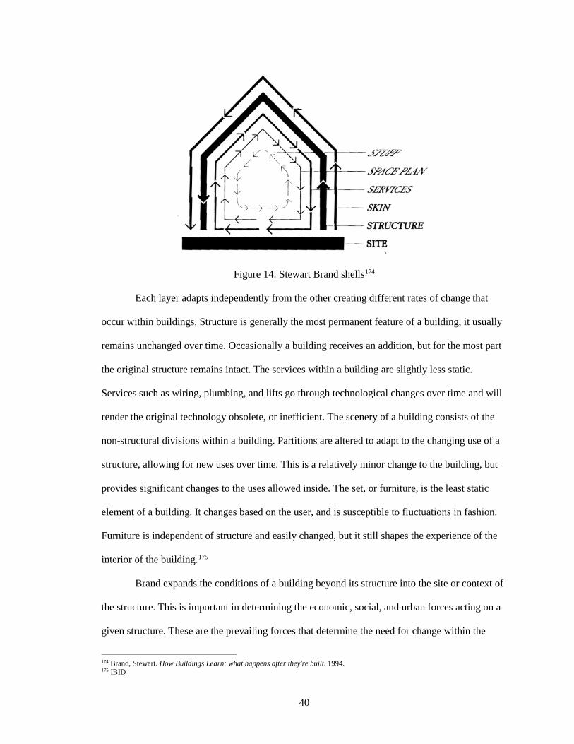
40
Figure 14: Stewart Brand shells174
Each layer adapts independently from the other creating different rates of change that
occur within buildings. Structure is generally the most permanent feature of a building, it usually
remains unchanged over time. Occasionally a building receives an addition, but for the most part
the original structure remains intact. The services within a building are slightly less static.
Services such as wiring, plumbing, and lifts go through technological changes over time and will
render the original technology obsolete, or inefficient. The scenery of a building consists of the
non-structural divisions within a building. Partitions are altered to adapt to the changing use of a
structure, allowing for new uses over time. This is a relatively minor change to the building, but
provides significant changes to the uses allowed inside. The set, or furniture, is the least static
element of a building. It changes based on the user, and is susceptible to fluctuations in fashion.
Furniture is independent of structure and easily changed, but it still shapes the experience of the
interior of the building.175
Brand expands the conditions of a building beyond its structure into the site or context of
the structure. This is important in determining the economic, social, and urban forces acting on a
given structure. These are the prevailing forces that determine the need for change within the
174 Brand, Stewart. How Buildings Learn: what happens after they're built. 1994. 175 IBID
41
subsequent categories. Brand separates the structure of a building from the skin. The structure is
altered far less than the envelope of a structure, due to the exposure to the elements. The skin of a
building is replaced at standard intervals to maintain insulation from the elements.176
A relative hierarchy is established within each category across time, rate of change, and
cost of change. The cheapest, most rapid, and least costly method of change is the “stuff” found
within a structure, and the site is the most static. This hierarchy is exhibited in structures we see
today.
Adaptive buildings allow ‘slippage’ between layers. Slower layers block quick changes,
while quick layers “tear up” the slow. Embedding these different layers may appear more
efficient initially, but cause conflicts over time. Growth does not equal adaptation. When a
building is able to age while providing adaptability, it becomes more valued.177
Brand discusses how the program of a building is a prediction (one that is often wrong).
He explains that program can be too specific, short term, and static. Programs should incorporate
multiple scenarios into their outcomes in order to provide adaptability for the future. He argues
medium-sized spaces are the most adaptable, and believes storage is adaptable - these unfinished
spaces can change use over time and allow reconfiguration in the future.178 He highlights that
designing around a specific technology can limit adaptability over time due to the rapid evolution
and progression of technology.
Brand’s architectural observations, categorization, and theories focus on the rates of
change present in all architecture. He explores architecture as infrastructure, composed of several
layers each experiencing change at predictable intervals due to weathering, technology upgrades,
new inhabitants, and programmatic changes. His thinking highlights the need for designers to
consider the programs, users, and technology of the future.
176 Brand, Stewart. How Buildings Learn: what happens after they're built. 1994. 177 IBID 178 IBID
42
2. Social Urbanism
The term “social urbanism” was coined to describe the physical intervention projects that
were implemented in the poorer sectors of Medellin from 2002-2010. 179 180 Public investment
was shifted to poor neighborhoods to provide infrastructure, public buildings, and service
upgrades, incorporating urban space and environmental improvements. Functionally, it improved
the provision and access to services, and improved quality of life. It also resulted in aesthetic
improvements, leading to high quality architecture that promoted a sense of inclusion into the
broader city of Medellin. This upgrading method was applied to many types of projects ranging
from an aerial cable-car to new schools and public spaces.181 The signature features of Medellin’s
social urbanism are the cable-cars, known as Metrocables. Their construction was the first
application of tourist infrastructure technology for public transport to serve urban poor, and to
connect them to the existing metro system.182
Another design feature of social urbanism in Medellin is the “library-park.” Library-
parks were conceived of as visual affirmations signaling state presence in communas. They
provide access to computer and information technology, training courses, cultural activities,
spaces for sport and recreation, social programs, business incubators, and more. Architecture
played a key role in signaling state presence. These sleek, minimalist buildings stand out for their
scale, form, materials, and color, in stark contrast to the surrounding informal and chaotic
appearing communa.183
In Medellin, social urbanism was important to redefining the city’s image as a
progressive, enlightened, and innovative place. This external success partially eclipsed the social
aims of social urbanism; local success, however, has superseded this ambition, raising the
179 Echeverri, A. and Orsini, F. “Informalidad y urbanismo social en Medellín” in Medellín: Medio Ambiente, Urbanismo y Sociedad. Medellín: Universidad EAFIT. 2010. 180 Architectural Review. “AR Special issue: recent work in Colombia ‘How architecture is healing the public realm. A tale of two cities – Bogotá and Medellín.’” CCXXIX, 1368. 2011. 181 Brand, Peter. “Governing inequality in the South through the Barcelona model: ‘social urbanism’ in Medellin, Colombia.” Paper presented at the “Interrogating Urban Crisis: Governance, Contestation, Critique” conference, De Montfort University, Leicester, United Kingdom, September 9-11, 2013. 182 IBID 183 Brand, Peter. “Governing inequality in the South through the Barcelona model: ‘social urbanism’ in Medellin, Colombia.” 2013.
43
standard of living, safety, outlook, and legitimacy for the residents of the communa.184 Social
urbanism provides the underpinning theories, approaches, and social aims required when
addressing slum upgrading. It provides methods of introducing various types of infrastructure,
community engagement, as well as policy frameworks necessary to upgrading slums.
3. Cradle-to-Cradle
Waste has long been approached with a “cradle-to-grave” mentality, which treats
materials as a waste management problem that has an impact natural systems, where “cradle”
represents manufacturing and “grave” suggests disposal.185 “Cradle-to-cradle” is a new approach
to design based on the closed-loop nutrient cycles present in nature, in which waste is not
unwanted, but instead serves as nutrition for another entity. This thinking was developed and
popularized by architect William McDonough and chemist Michael Braungart in their 2002 book,
Cradle to Cradle: Remaking the Way We Make Things.
As in nature, “cradle-to-cradle” design aims to create buildings, communities, and
systems that generate wholly positive effects for human and environmental health beginning with
the initial stages of design. Attempts are not made to reduce waste, instead waste is re-assessed
for possible positive uses. This approach suggests one should anticipate the design, materials, and
embedded energy of a project beyond a product's life cycle. In nature, one organism’s waste
serves as another’s food. Nutrients and energy flow continuously in closed-loop systems of
growth, decay, and rebirth.186
The concept “reduce, reuse, recycle” is fundamental to the cradle-to-cradle design
approach. The first step is to reduce the amount that we consume, and to consume well-designed
products and services. Finding constructive uses for “waste” and byproducts should follow.
184 Brand, Peter. “Governing inequality in the South through the Barcelona model: ‘social urbanism’ in Medellin, Colombia.” 2013. 185 Beame, Susie. "Cradle to Grave vs Cradle to Cradle." Design Industry 2009. January 01, 1970. 186 IBID
44
Recycling is the last step, and ideally limited in the cradle-to-cradle design approach due to
efficient reuse.187
The “cradle-to-cradle” design theory is an active movement committed to developing
safe materials, products, supply chains, and manufacturing processes in architecture and industry.
When architectural designs are modeled after this concept, they create useful, practical and
sustainable places to live. It encourages a stronger sense of community and cooperation, and also
allows for efficiency and cost-effectiveness to play larger roles.188
4. Flexible Housing
Jeremy Till and Tatjana Schneider’s “Flexible Housing: The Means to the End” outlines
methods that can be used to achieve flexible housing. It argues that flexible housing is an
essential part of future housing because of its emphasis on social, economic, and environmental
sustainability. Flexible housing is defined as “housing that can adapt to the changing needs of
users.”189 The resulting architecture is intentionally broad to allow for different interpretations
and housing layouts. It also leaves room to incorporate new technologies over time, and to adjust
to changing demographics or program throughout the building.
Flexibility is explored through determinate and indeterminate design, also known as
“hard” and “soft” systems. Previous approaches toward flexibility adopted all-or-nothing
approaches that were technically off-putting to designers or developers. Till and Schneider’s
process proposes alternative methods to achieve flexibility that allow a range of possibilities from
wholesale change to discrete alterations.190
In order to achieve flexibility, design should seek to “design out inflexibility,” using three
approaches. First, construction methods should seek to reduce load bearing or solid internal
partitions, as well as avoid roof construction that limits future expansion. Second, technological
187 Beame, Susie. "Cradle to Grave vs Cradle to Cradle." Design Industry 2009. January 01, 1970. 188 IBID 189 Till, Jeremy and Schneider, Tatjana. “Flexible Housing: the means to the end.” Architectural Research Quarterly 9, no. 3-4 (2005): 287-296. 190 IBID
45
choices should be considered in order to reduce non-accessible or non-adaptable services. Third,
space should be considered to eliminate tight-fit functions and rooms that can be used or accessed
in only one way. These methods help avoid inflexibility.191
Till and Schneider researched various examples of flexible housing and discovered the
terraced house, a row house typology common in England since the 17th century, was a common
and effective example of flexible housing. They observed that over time these terraced houses
had been modified both horizontally and vertically, and were divided, joined, and used for
multiple other purposes than their initial intended program. Terraced houses possessed relatively
generous space compared to contemporary housing standards. The adaptability of the space
allowed for subdivision within the structure, often leading to room partitioning, the addition of a
bathroom, or in the case of high ceilings, allowed for lofts and false ceilings. Terraced houses
were constructed using repetitive simple techniques, making it easy for unskilled labor to alter the
space.192
From these observations Till and Schneider devised generic principles for achieving
flexible housing. A correlation exists between the amount of space and level of flexibility.
Limited space may appear to limit flexibility, but encourages and demands multiple uses. The
complexity of construction methods used can severely limit the flexibility of a given structure.
Simple and robust construction techniques allow for future modifications. If specialist
construction methods or services are required, they should be placed in accessible and separate
zones so that only one set of specialists is required to make changes. The placement of staircases,
service cores, or entrances allow future flexibility at no extra cost, but must be considered in the
early stages of design.193
Recalling Stewart Brand’s work, the identification of layers in construction range from
structure, skin, services, internal partitions to finishes. External shells are inflexible, while cores
191 Till, Jeremy and Schneider, Tatjana. “Flexible Housing: the means to the end.” 2005. 192 IBID 193 IBID
46
provide access and services. The space within is indeterminate with large spaces, and allows for
the addition and removal of partitions. Services can be placed vertically in accessible ducts, while
horizontal services can be tucked under raised floors or dropped ceilings, thus allowing for
services to be distributed anywhere, and to provide ease of access. Each can be categorized into
the broader categories: “hard” and “soft.”194
“Soft” use allows the user to adapt the plan according to their needs; here the designer
works in the background. “Hard” use places the designer in the foreground; they are responsible
for determining how spaces can be used over time. “Soft” generally requires more space,
redundancy, and a reduced approach to planning and technology. “Hard” use is appropriate when
space is scarce and multifunctionality is important.195
Modernist housing of the 1920s and 30s responded to a housing shortage that occurred
after WWI through the provision of housing with rooms that were undefined. New structural
systems allowed indeterminate space to emerge as a new type available to early modernists. It
accommodated longer spans and non-structural partitions. This approach made room for flexible
modules that could vary in size and repetition. The occupation and program of the rooms was
determined by the occupants. Similarly sized spaces with separate zones for circulation and
services give way to multiple configurations from individual to household occupation. Future
changes are made with ease, however coordination with adjacent apartments would be required
for expansion and contraction in the future. This suggests designers should provide raw space that
can be divided according to the needs of occupants. However, open space alone can be inefficient
in terms of space usage.196
“Soft” space lends itself to a participative approach to design. It allows tenants to control
spaces during the design stages of a project and throughout the life of the building. “Hard” use is
determined by the architect. Here the architect keeps control of the project, and is a much more
194 Till, Jeremy and Schneider, Tatjana. “Flexible Housing: the means to the end.” 2005. 195 IBID 196 IBID
47
common approach. “Hard” approaches work best when space is at a premium. Moving or folding
components that result in highly specific configurations are produced. It can require users to be
participants in an architectural experiment, leading to spaces that become more and more difficult
to rent and sell over time.197
Technology can also help achieve flexibility, when considering construction techniques,
structural solutions, and servicing strategies. “Hard” technology is developed specifically to
achieve flexibility and can be essential to a scheme. This led to the development of the “open
building movement.” Mass housing, an example of “hard” design, is a common approach to the
housing market, “reduces the dwelling to a consumer article and the dweller to consumer.”198
Instead users should be given control of the process of dwelling and should be considered as a
structure of supports (infrastructure) and infills (short-term user adaptations). This requires the
designer to relinquish control of portions of the design process, however. If flexibility is applied
at all scales it can become a means for social empowerment.199
“Soft” technology can create greater flexibility in structure over time. If load bearing
columns and beams are completely eliminated, partition walls can be removed to combine units
into larger units. The strategic placement of service cores is necessary to equip kitchens and
bathrooms, while allowing their position to remain somewhat flexible. Access to services is
required to allow future upgrades and should be distributed across the floor plate so they can be
accessed in any configuration.
Till and Schneider encourage designers to relinquish control of parts of their designs to
users for the creation of dwelling units. They encourage the consideration of hard and soft
infrastructures as a means to create flexible architecture. When flexibility is applied at all scales it
can become a means for social empowerment.
197 Till, Jeremy and Schneider, Tatjana. “Flexible Housing: the means to the end.” 2005. 198 IBID 199 IBID
48
B. Case Studies: Incremental Approaches
1. Kowloon Walled City
The site of the Kowloon Walled City at the northeastern corner of Kowloon peninsula
was first fortified in 1668 when a signal station was established. Since this date a small
fortification existed on this site in Hong Kong until it was developed by squatters. With two
governments claiming jurisdiction over it, the Walled City fell between two jurisdictions, one
undertook minimal administrative responsibility to avoid diplomatic embarrassment, the other
took no action at all. The result was a vacuum of administrative function and authority.200
Although squatters had filtered in after 1899, the population was still fewer than 500 in
the 1930s. Conditions were unsanitary but here residents were able to escape the over-crowding
of adjacent parts of the city. In 1933, the government announced plans to demolish the settlement
for its poor sanitation. By 1940, most buildings had been demolished, sparing only those used for
public purposes. The clearance continued under Japanese rule when the wall was torn down to
harvest materials to extend Kai Tak Airport.201
After WWII, refugees fled to Hong Kong where many settled in the Walled City. By
1947, the population had risen to 2,000. The Hong Kong government again attempted to expel
settlers, but no eviction took place. Instead, the area was left to its own devices developing into a
compact, vertical slum.202 The area experienced massive construction in the 1960s and developers
were forced to erect new buildings and structures above older ones. Over 30,000 people inhabited
300 buildings that occupied just over 7 acres (2.8 ha). The Walled City reached its maximum size
by the late 1970s due to a height restriction of 13-14 storeys, imposed by the adjacent Kai Tak
Airport flight paths.203 The proximity to the airport also subjected residents to significant noise
and air pollution for the final 20 years of the city’s existence.
200 Sinn, Elizabeth. “Kowloon Walled City: its origin and early history.” Journal of the Hong Kong Branch of the Royal Asiatic Society 27 (1987): 30-45. 201 Sinn, Elizabeth. “Kowloon Walled City: its origin and early history.” 1987. 202 IBID 203 Lambot, Ian. City of Darkness: Life in Kowloon Walled City. Honolulu: Watermark. 1999.
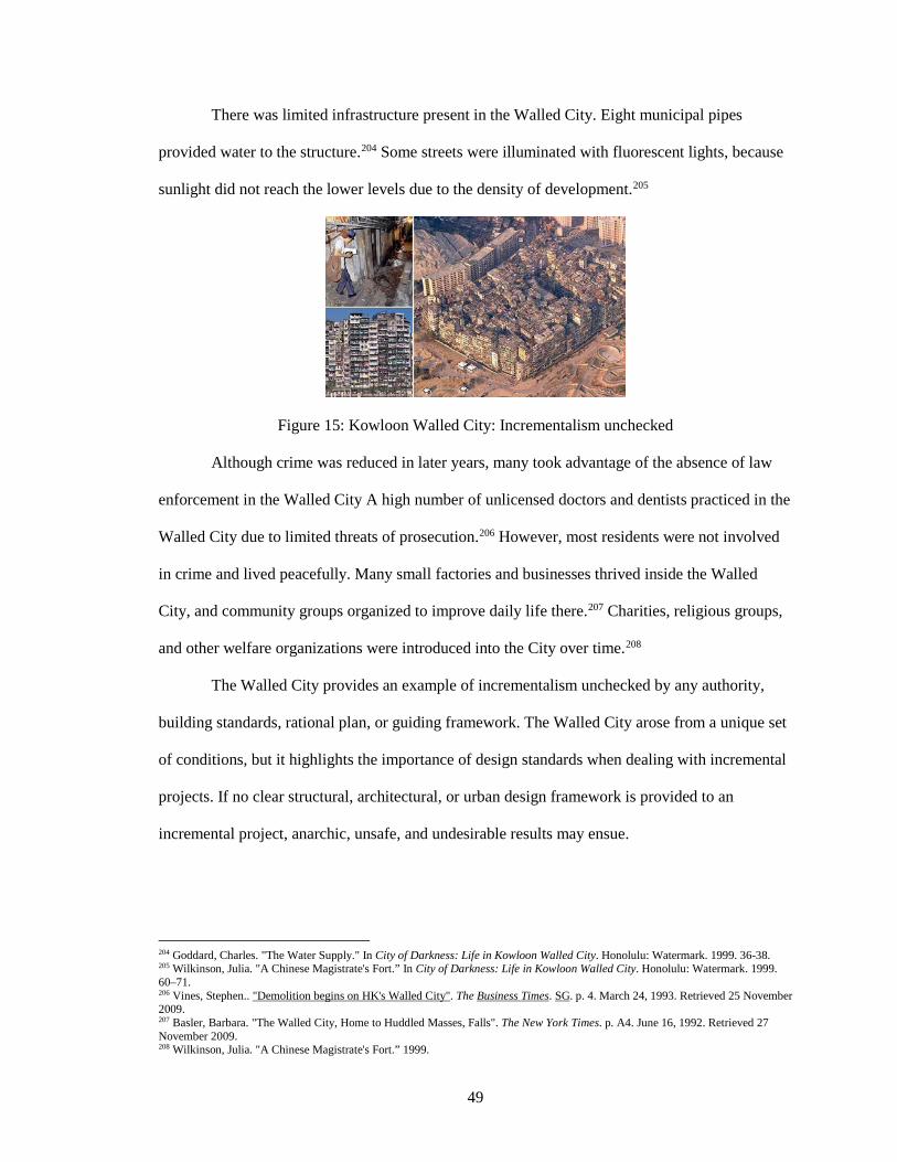
49
There was limited infrastructure present in the Walled City. Eight municipal pipes
provided water to the structure.204 Some streets were illuminated with fluorescent lights, because
sunlight did not reach the lower levels due to the density of development.205
Figure 15: Kowloon Walled City: Incrementalism unchecked
Although crime was reduced in later years, many took advantage of the absence of law
enforcement in the Walled City A high number of unlicensed doctors and dentists practiced in the
Walled City due to limited threats of prosecution.206 However, most residents were not involved
in crime and lived peacefully. Many small factories and businesses thrived inside the Walled
City, and community groups organized to improve daily life there.207 Charities, religious groups,
and other welfare organizations were introduced into the City over time.208
The Walled City provides an example of incrementalism unchecked by any authority,
building standards, rational plan, or guiding framework. The Walled City arose from a unique set
of conditions, but it highlights the importance of design standards when dealing with incremental
projects. If no clear structural, architectural, or urban design framework is provided to an
incremental project, anarchic, unsafe, and undesirable results may ensue.
204 Goddard, Charles. "The Water Supply." In City of Darkness: Life in Kowloon Walled City. Honolulu: Watermark. 1999. 36-38. 205 Wilkinson, Julia. "A Chinese Magistrate's Fort.” In City of Darkness: Life in Kowloon Walled City. Honolulu: Watermark. 1999. 60–71. 206 Vines, Stephen.. "Demolition begins on HK's Walled City". The Business Times. SG. p. 4. March 24, 1993. Retrieved 25 November 2009. 207 Basler, Barbara. "The Walled City, Home to Huddled Masses, Falls". The New York Times. p. A4. June 16, 1992. Retrieved 27 November 2009. 208 Wilkinson, Julia. "A Chinese Magistrate's Fort.” 1999.
50
2. Japanese Metabolism
The Japanese Metabolist movement arose from rapid development and housing shortages
similar to the conditions found in developing cities throughout the world. Land was held by
multiple landowners with few large landholders. This caused the development patterns of the city
to occur incrementally, and without large social housing projects.
The Metabolist movement promoted top-down solutions. Architects were “social
architects.” reimagining the way individuals interacted as well as the framework of the entire city
of Tokyo. The plans for Tokyo called for massive infrastructural projects that would “grow” over
time according to demand. While this approach is grounded in incrementalism, the proposed
plans required individuals to adapt to architectural plans. Individual choice, design freedom, and
community empowerment were overlooked in order to adhere to the architect’s vision.
After the second World War, most of Tokyo required rebuilding. The city expanded at a
rapid pace, especially in 1950 at the onset of the Korean War. Despite massive reconstruction and
rapid industrialization, Tokyo retained its pre-modern urban structure passed down from the
feudal era. The city developed piecemeal; new housing was built to accommodate the surge in
population, and infrastructure lagged behind. The various issues facing Tokyo during this period
included: “the vast population movement, fast proliferation of automobiles, inadequacy of social
services, shortage of land and widespread private land ownership, as well as initial inexperience
of the authorities in charge all contributed to Tokyo’s predicament.”209 During the five years after
the war Tokyo’s population grew from 2.78 million to 5.38 million. The population surged as a
result of “evacuees and soldiers returning from war, repatriated Japanese from lost colonies, and
thousands upon thousands of desperate job seekers from impoverished prefectures and devastated
cities.”210 Growth continued throughout the 1950s reaching 8.31 million by the end of the decade.
209 Lin, Zhongjie. Kenzo Tange and the Metabolist movement: urban utopias of modern Japan. Abingdon: Routledge. 2010. 134. 210 IBID
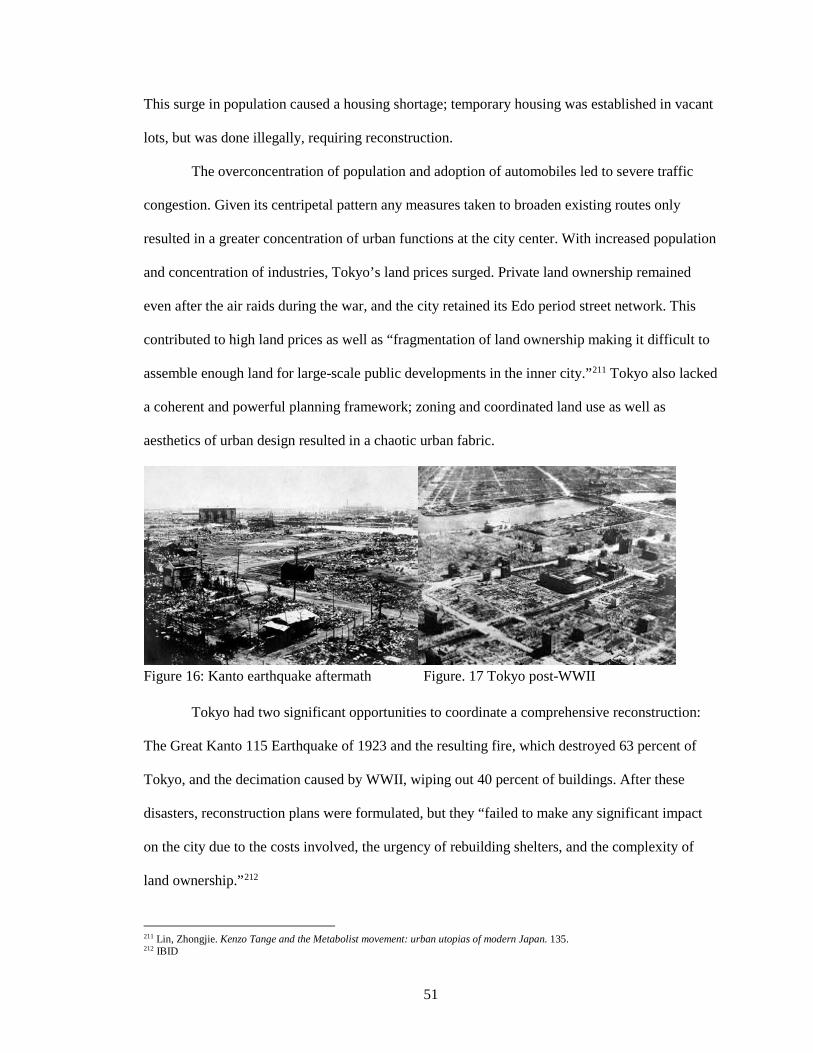
51
This surge in population caused a housing shortage; temporary housing was established in vacant
lots, but was done illegally, requiring reconstruction.
The overconcentration of population and adoption of automobiles led to severe traffic
congestion. Given its centripetal pattern any measures taken to broaden existing routes only
resulted in a greater concentration of urban functions at the city center. With increased population
and concentration of industries, Tokyo’s land prices surged. Private land ownership remained
even after the air raids during the war, and the city retained its Edo period street network. This
contributed to high land prices as well as “fragmentation of land ownership making it difficult to
assemble enough land for large-scale public developments in the inner city.”211 Tokyo also lacked
a coherent and powerful planning framework; zoning and coordinated land use as well as
aesthetics of urban design resulted in a chaotic urban fabric.
Figure 16: Kanto earthquake aftermath Figure. 17 Tokyo post-WWII Tokyo had two significant opportunities to coordinate a comprehensive reconstruction:
The Great Kanto 115 Earthquake of 1923 and the resulting fire, which destroyed 63 percent of
Tokyo, and the decimation caused by WWII, wiping out 40 percent of buildings. After these
disasters, reconstruction plans were formulated, but they “failed to make any significant impact
on the city due to the costs involved, the urgency of rebuilding shelters, and the complexity of
land ownership.”212
211 Lin, Zhongjie. Kenzo Tange and the Metabolist movement: urban utopias of modern Japan. 135. 212 IBID
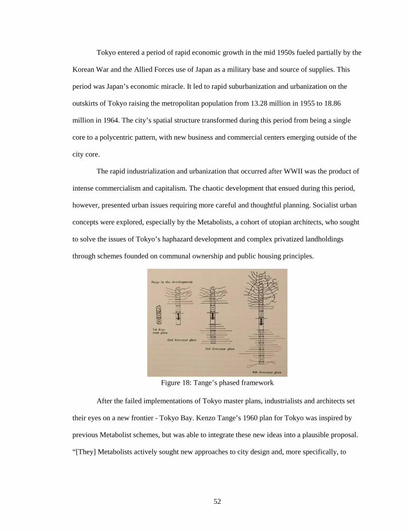
52
Tokyo entered a period of rapid economic growth in the mid 1950s fueled partially by the
Korean War and the Allied Forces use of Japan as a military base and source of supplies. This
period was Japan’s economic miracle. It led to rapid suburbanization and urbanization on the
outskirts of Tokyo raising the metropolitan population from 13.28 million in 1955 to 18.86
million in 1964. The city’s spatial structure transformed during this period from being a single
core to a polycentric pattern, with new business and commercial centers emerging outside of the
city core.
The rapid industrialization and urbanization that occurred after WWII was the product of
intense commercialism and capitalism. The chaotic development that ensued during this period,
however, presented urban issues requiring more careful and thoughtful planning. Socialist urban
concepts were explored, especially by the Metabolists, a cohort of utopian architects, who sought
to solve the issues of Tokyo’s haphazard development and complex privatized landholdings
through schemes founded on communal ownership and public housing principles.
Figure 18: Tange’s phased framework
After the failed implementations of Tokyo master plans, industrialists and architects set
their eyes on a new frontier - Tokyo Bay. Kenzo Tange’s 1960 plan for Tokyo was inspired by
previous Metabolist schemes, but was able to integrate these new ideas into a plausible proposal.
“[They] Metabolists actively sought new approaches to city design and, more specifically, to
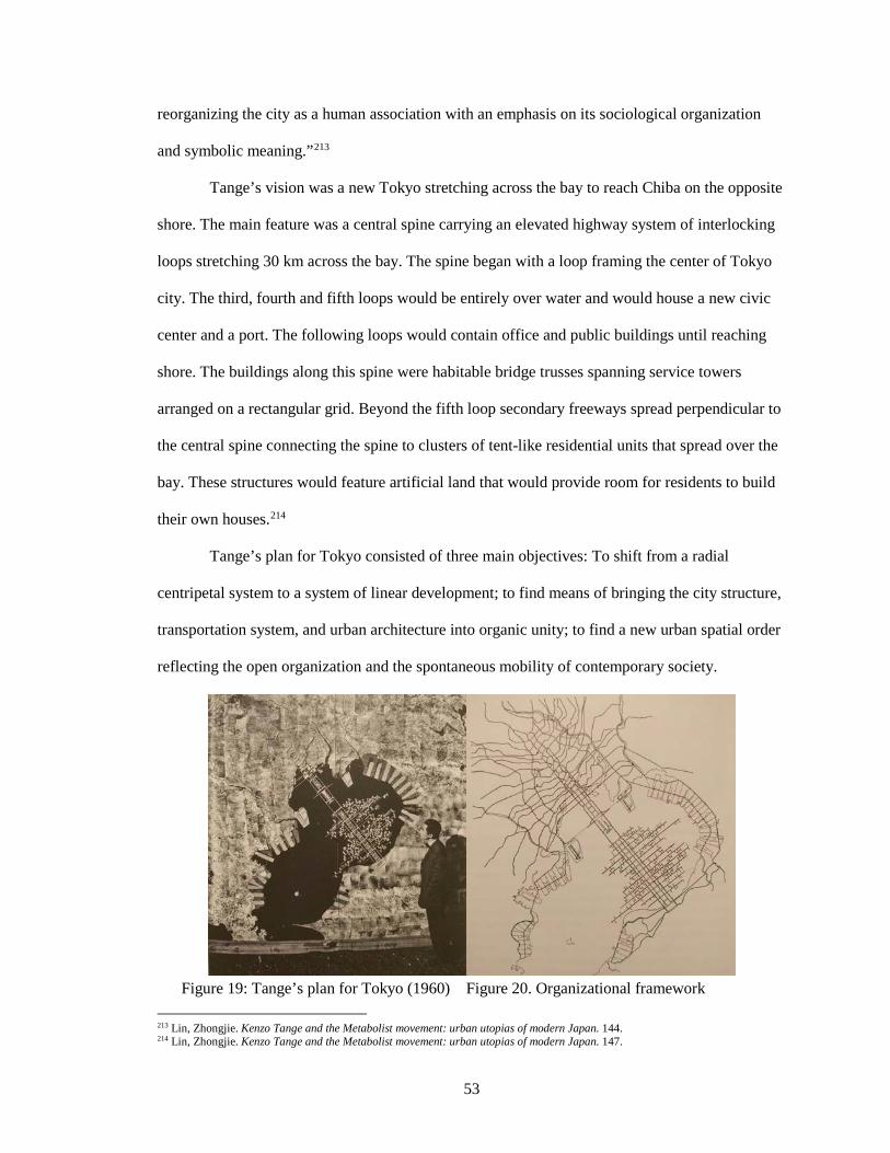
53
reorganizing the city as a human association with an emphasis on its sociological organization
and symbolic meaning.”213
Tange’s vision was a new Tokyo stretching across the bay to reach Chiba on the opposite
shore. The main feature was a central spine carrying an elevated highway system of interlocking
loops stretching 30 km across the bay. The spine began with a loop framing the center of Tokyo
city. The third, fourth and fifth loops would be entirely over water and would house a new civic
center and a port. The following loops would contain office and public buildings until reaching
shore. The buildings along this spine were habitable bridge trusses spanning service towers
arranged on a rectangular grid. Beyond the fifth loop secondary freeways spread perpendicular to
the central spine connecting the spine to clusters of tent-like residential units that spread over the
bay. These structures would feature artificial land that would provide room for residents to build
their own houses.214
Tange’s plan for Tokyo consisted of three main objectives: To shift from a radial
centripetal system to a system of linear development; to find means of bringing the city structure,
transportation system, and urban architecture into organic unity; to find a new urban spatial order
reflecting the open organization and the spontaneous mobility of contemporary society.
Figure 19: Tange’s plan for Tokyo (1960) Figure 20. Organizational framework 213 Lin, Zhongjie. Kenzo Tange and the Metabolist movement: urban utopias of modern Japan. 144. 214 Lin, Zhongjie. Kenzo Tange and the Metabolist movement: urban utopias of modern Japan. 147.
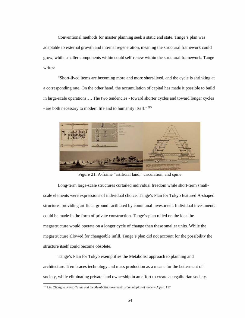
54
Conventional methods for master planning seek a static end state. Tange’s plan was
adaptable to external growth and internal regeneration, meaning the structural framework could
grow, while smaller components within could self-renew within the structural framework. Tange
writes:
“Short-lived items are becoming more and more short-lived, and the cycle is shrinking at
a corresponding rate. On the other hand, the accumulation of capital has made it possible to build
in large-scale operations…. The two tendencies - toward shorter cycles and toward longer cycles
- are both necessary to modern life and to humanity itself.”215
Figure 21: A-frame “artificial land,” circulation, and spine
Long-term large-scale structures curtailed individual freedom while short-term small-
scale elements were expressions of individual choice. Tange’s Plan for Tokyo featured A-shaped
structures providing artificial ground facilitated by communal investment. Individual investments
could be made in the form of private construction. Tange’s plan relied on the idea the
megastructure would operate on a longer cycle of change than these smaller units. While the
megastructure allowed for changeable infill, Tange’s plan did not account for the possibility the
structure itself could become obsolete.
Tange’s Plan for Tokyo exemplifies the Metabolist approach to planning and
architecture. It embraces technology and mass production as a means for the betterment of
society, while eliminating private land ownership in an effort to create an egalitarian society. 215 Lin, Zhongjie. Kenzo Tange and the Metabolist movement: urban utopias of modern Japan. 117.
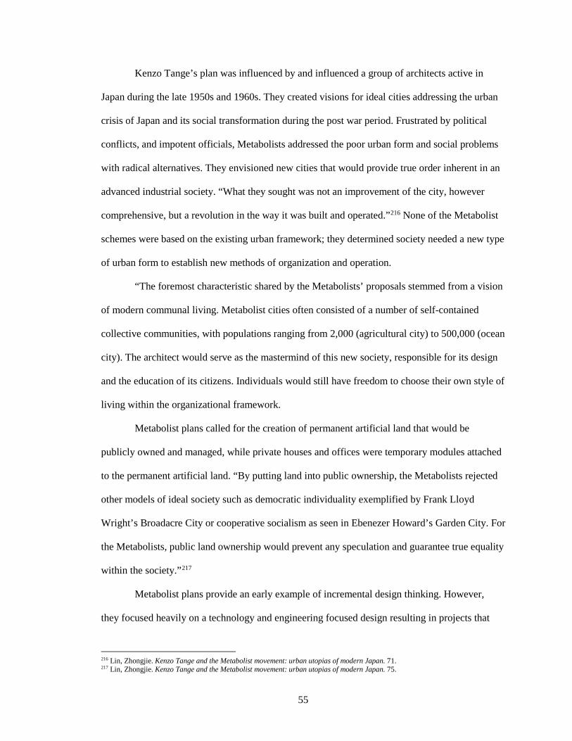
55
Kenzo Tange’s plan was influenced by and influenced a group of architects active in
Japan during the late 1950s and 1960s. They created visions for ideal cities addressing the urban
crisis of Japan and its social transformation during the post war period. Frustrated by political
conflicts, and impotent officials, Metabolists addressed the poor urban form and social problems
with radical alternatives. They envisioned new cities that would provide true order inherent in an
advanced industrial society. “What they sought was not an improvement of the city, however
comprehensive, but a revolution in the way it was built and operated.”216 None of the Metabolist
schemes were based on the existing urban framework; they determined society needed a new type
of urban form to establish new methods of organization and operation.
“The foremost characteristic shared by the Metabolists’ proposals stemmed from a vision
of modern communal living. Metabolist cities often consisted of a number of self-contained
collective communities, with populations ranging from 2,000 (agricultural city) to 500,000 (ocean
city). The architect would serve as the mastermind of this new society, responsible for its design
and the education of its citizens. Individuals would still have freedom to choose their own style of
living within the organizational framework.
Metabolist plans called for the creation of permanent artificial land that would be
publicly owned and managed, while private houses and offices were temporary modules attached
to the permanent artificial land. “By putting land into public ownership, the Metabolists rejected
other models of ideal society such as democratic individuality exemplified by Frank Lloyd
Wright’s Broadacre City or cooperative socialism as seen in Ebenezer Howard’s Garden City. For
the Metabolists, public land ownership would prevent any speculation and guarantee true equality
within the society.”217
Metabolist plans provide an early example of incremental design thinking. However,
they focused heavily on a technology and engineering focused design resulting in projects that
216 Lin, Zhongjie. Kenzo Tange and the Metabolist movement: urban utopias of modern Japan. 71. 217 Lin, Zhongjie. Kenzo Tange and the Metabolist movement: urban utopias of modern Japan. 75.
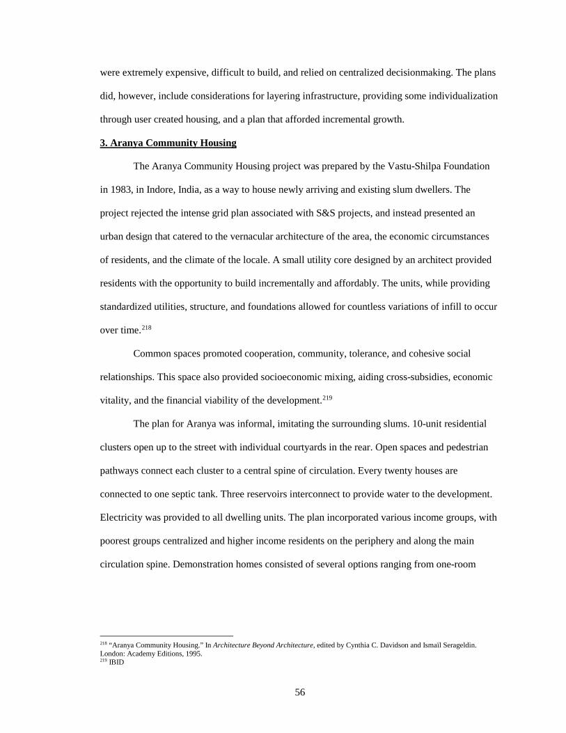
56
were extremely expensive, difficult to build, and relied on centralized decisionmaking. The plans
did, however, include considerations for layering infrastructure, providing some individualization
through user created housing, and a plan that afforded incremental growth.
3. Aranya Community Housing
The Aranya Community Housing project was prepared by the Vastu-Shilpa Foundation
in 1983, in Indore, India, as a way to house newly arriving and existing slum dwellers. The
project rejected the intense grid plan associated with S&S projects, and instead presented an
urban design that catered to the vernacular architecture of the area, the economic circumstances
of residents, and the climate of the locale. A small utility core designed by an architect provided
residents with the opportunity to build incrementally and affordably. The units, while providing
standardized utilities, structure, and foundations allowed for countless variations of infill to occur
over time.218
Common spaces promoted cooperation, community, tolerance, and cohesive social
relationships. This space also provided socioeconomic mixing, aiding cross-subsidies, economic
vitality, and the financial viability of the development.219
The plan for Aranya was informal, imitating the surrounding slums. 10-unit residential
clusters open up to the street with individual courtyards in the rear. Open spaces and pedestrian
pathways connect each cluster to a central spine of circulation. Every twenty houses are
connected to one septic tank. Three reservoirs interconnect to provide water to the development.
Electricity was provided to all dwelling units. The plan incorporated various income groups, with
poorest groups centralized and higher income residents on the periphery and along the main
circulation spine. Demonstration homes consisted of several options ranging from one-room
218 “Aranya Community Housing.” In Architecture Beyond Architecture, edited by Cynthia C. Davidson and Ismaïl Serageldin. London: Academy Editions, 1995. 219 IBID
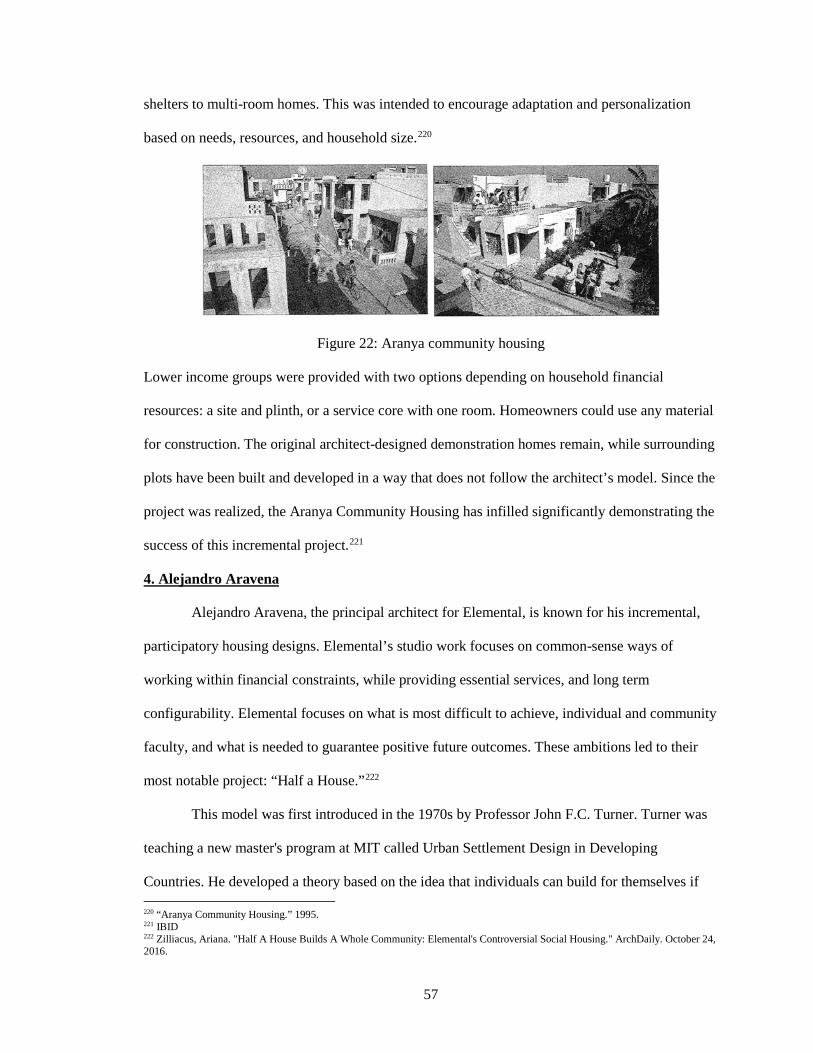
57
shelters to multi-room homes. This was intended to encourage adaptation and personalization
based on needs, resources, and household size.220
Figure 22: Aranya community housing
Lower income groups were provided with two options depending on household financial
resources: a site and plinth, or a service core with one room. Homeowners could use any material
for construction. The original architect-designed demonstration homes remain, while surrounding
plots have been built and developed in a way that does not follow the architect’s model. Since the
project was realized, the Aranya Community Housing has infilled significantly demonstrating the
success of this incremental project.221
4. Alejandro Aravena
Alejandro Aravena, the principal architect for Elemental, is known for his incremental,
participatory housing designs. Elemental’s studio work focuses on common-sense ways of
working within financial constraints, while providing essential services, and long term
configurability. Elemental focuses on what is most difficult to achieve, individual and community
faculty, and what is needed to guarantee positive future outcomes. These ambitions led to their
most notable project: “Half a House.”222
This model was first introduced in the 1970s by Professor John F.C. Turner. Turner was
teaching a new master's program at MIT called Urban Settlement Design in Developing
Countries. He developed a theory based on the idea that individuals can build for themselves if 220 “Aranya Community Housing.” 1995. 221 IBID 222 Zilliacus, Ariana. "Half A House Builds A Whole Community: Elemental's Controversial Social Housing." ArchDaily. October 24, 2016.
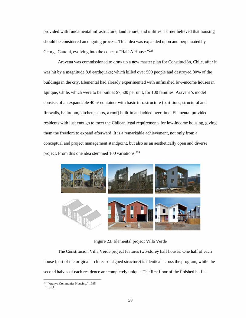
58
provided with fundamental infrastructure, land tenure, and utilities. Turner believed that housing
should be considered an ongoing process. This Idea was expanded upon and perpetuated by
George Gattoni, evolving into the concept “Half A House.”223
Aravena was commissioned to draw up a new master plan for Constitución, Chile, after it
was hit by a magnitude 8.8 earthquake; which killed over 500 people and destroyed 80% of the
buildings in the city. Elemental had already experimented with unfinished low-income houses in
Iquique, Chile, which were to be built at $7,500 per unit, for 100 families. Aravena’s model
consists of an expandable 40m² container with basic infrastructure (partitions, structural and
firewalls, bathroom, kitchen, stairs, a roof) built-in and added over time. Elemental provided
residents with just enough to meet the Chilean legal requirements for low-income housing, giving
them the freedom to expand afterward. It is a remarkable achievement, not only from a
conceptual and project management standpoint, but also as an aesthetically open and diverse
project. From this one idea stemmed 100 variations.224
Figure 23: Elemental project Villa Verde
The Constitución Villa Verde project features two-storey half houses. One half of each
house (part of the original architect-designed structure) is identical across the program, while the
second halves of each residence are completely unique. The first floor of the finished half is
223 “Aranya Community Housing.” 1995. 224 IBID
59
comprises unfinished concrete floors, while the second floor is fitted with unfinished plywood.
The kitchen features one sink with no other appliances. This makes the house cheap, practical,
and efficient. Fundamental structural and architectural needs were provided to residents,
including concrete foundations, plumbing, and electricity. The Chilean government paid for,
constructed, and provided roads, drainage, sewage, garbage collection, busses and other vital
infrastructure important to fostering community. Residents were responsible for contributing
time, labor, and any additional materials.225
Residents were given the option to participate in community design meetings hosted by
Elemental. Each homeowner received a manual highlighting ways to expand using standard
affordable building materials. The project aims to offer residents a higher quality home than what
they otherwise would have been able to construct themselves or receive support to do so. Efforts
were made to make the architecture highly affordable and basic so any extra resources could go
into improving the surrounding area uplifting the neighborhood, showcasing Elemental’s social
conscience.
Elemental has produced low-income houses with architecture that is disaster resistant.
The concept appears to be succeeding in using “scarcity as a tool.” Alejandro Aravena has
recently been recognized by the architectural community, winning the Pritzker Prize in 2016, for
epitomizing “the revival of a more socially engaged architect…fighting for a better urban
environment for all.”226
Participatory design has been lauded as a means to face the challenges of unprecedented
urbanization and urban poverty. However, little has been written about the way information-
sharing can be a disruptor to the construction industry. Aravena recently made some of his
socially oriented architectural projects open source online, making it available to anyone with
internet access.227
225 Zilliacus, Ariana. "Half A House Builds A Whole Community: Elemental's Controversial Social Housing." 226 IBID 227 "Why Aravena's Open Source Project is a Huge Step Toward Better, Cheaper Housing for Everyone." ArchDaily. April 29, 2016.
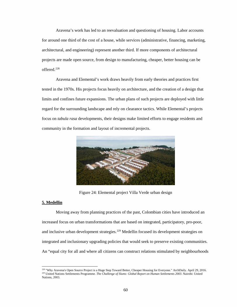
60
Aravena’s work has led to an reevaluation and questioning of housing. Labor accounts
for around one third of the cost of a house, while services (administrative, financing, marketing,
architectural, and engineering) represent another third. If more components of architectural
projects are made open source, from design to manufacturing, cheaper, better housing can be
offered.228
Aravena and Elemental’s work draws heavily from early theories and practices first
tested in the 1970s. His projects focus heavily on architecture, and the creation of a design that
limits and confines future expansions. The urban plans of such projects are deployed with little
regard for the surrounding landscape and rely on clearance tactics. While Elemental’s projects
focus on tabula rasa developments, their designs make limited efforts to engage residents and
community in the formation and layout of incremental projects.
Figure 24: Elemental project Villa Verde urban design 5. Medellin
Moving away from planning practices of the past, Colombian cities have introduced an
increased focus on urban transformations that are based on integrated, participatory, pro-poor,
and inclusive urban development strategies.229 Medellin focused its development strategies on
integrated and inclusionary upgrading policies that would seek to preserve existing communities.
An “equal city for all and where all citizens can construct relations stimulated by neighbourhoods
228 "Why Aravena's Open Source Project is a Huge Step Toward Better, Cheaper Housing for Everyone." ArchDaily. April 29, 2016. 229 United Nations Settlements Programme. The Challenge of Slums: Global Report on Human Settlements 2003. Nairobi: United Nations, 2003.
61
rich in services, culture and public space” became the main goal of the 3-year development plan
of Medellin 2004-2007.230 Deprived neighborhoods of the city were seen as a limitation to
improve Medellin as a whole. Therefore, poverty, inequity, violence, and the lack of participatory
governance were identified as obstacles for achieving Medellin’s goals. This led to integrated and
participatory upgrading projects given highest priority in the political arena. Local administration
saw this as strategic, believing that improving the social, economic, and spatial problems of these
neighborhoods would contribute to the development of the city as a whole.231
The ideas developed by designers and planners in Medellin were collected by the local
administration into a strategy of urban development coined “social urbansim.” This became the
main framework for all urban projects in Medellin, especially in communa neighborhoods.232 It
was conceived as a development strategy that combined physical transformations,
social/institutional programs, and participatory processes simultaneously. Social urbanism’s
objective was: “whenever there was an urban intervention, in parallel to the physical
transformation, there were new social/institutional programs and activities that complemented the
physical change.”233 Social and institutional programs would reinforce and make active use of
new public spaces and public facilities. This was done through an integrated approach that
engaged multiple municipal agencies and involved the community at different stages of the
project.
The first Proyecto Urbano Integral (PUI) was located in northeastern Medellin. Its
approach was to concentrate on a delineated area with an integrated intervention that converged
resources, projects, and programs of the government. It was thought that this strategy would
create more impactful, faster, and more visible results for the area. Three components informing
the project were: physical components, based on new public spaces and facilities; social 230 Municipio de Medellin. “Plan de desarrollo 2004 - 2007 ‘Medellin, Compromiso de toda la Ciudadania.’” Medellin: Municipio de Medellin. 2004. 231 IBID 232 BID. Medellin - Transformacion de una ciudad. Medellin: BID - Banco Interoamericano de Desarrollo, Alcaldia de Medellin. 2009. 233 Echeverri, A. “La Transformación de Medellín - Urbanismo Social 2004-2007.” Presented to the Sociedad Central de Arquitectos, Medellin, Colombia, April 20, 2009.
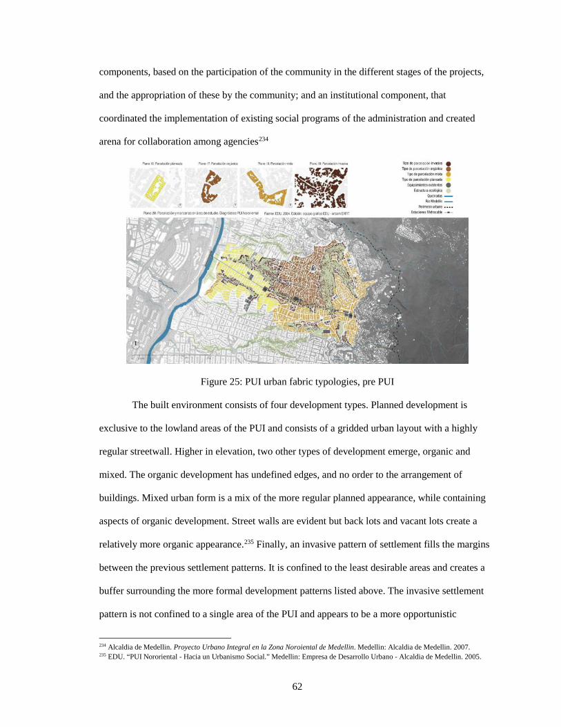
62
components, based on the participation of the community in the different stages of the projects,
and the appropriation of these by the community; and an institutional component, that
coordinated the implementation of existing social programs of the administration and created
arena for collaboration among agencies234
Figure 25: PUI urban fabric typologies, pre PUI
The built environment consists of four development types. Planned development is
exclusive to the lowland areas of the PUI and consists of a gridded urban layout with a highly
regular streetwall. Higher in elevation, two other types of development emerge, organic and
mixed. The organic development has undefined edges, and no order to the arrangement of
buildings. Mixed urban form is a mix of the more regular planned appearance, while containing
aspects of organic development. Street walls are evident but back lots and vacant lots create a
relatively more organic appearance.235 Finally, an invasive pattern of settlement fills the margins
between the previous settlement patterns. It is confined to the least desirable areas and creates a
buffer surrounding the more formal development patterns listed above. The invasive settlement
pattern is not confined to a single area of the PUI and appears to be a more opportunistic
234 Alcaldia de Medellin. Proyecto Urbano Integral en la Zona Noroiental de Medellin. Medellin: Alcaldia de Medellin. 2007. 235 EDU. “PUI Nororiental - Hacia un Urbanismo Social.” Medellin: Empresa de Desarrollo Urbano - Alcaldia de Medellin. 2005.
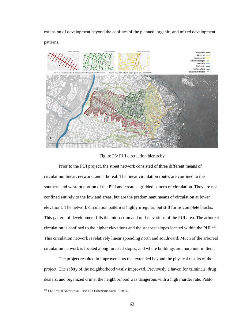
63
extension of development beyond the confines of the planned, organic, and mixed development
patterns.
Figure 26: PUI circulation hierarchy
Prior to the PUI project, the street network consisted of three different means of
circulation: linear, network, and arboreal. The linear circulation routes are confined to the
southern and western portion of the PUI and create a gridded pattern of circulation. They are not
confined entirely to the lowland areas, but are the predominant means of circulation at lower
elevations. The network circulation pattern is highly irregular, but still forms complete blocks.
This pattern of development fills the midsection and mid-elevations of the PUI area. The arboreal
circulation is confined to the higher elevations and the steepest slopes located within the PUI.236
This circulation network is relatively linear spreading north and southward. Much of the arboreal
circulation network is located along forested slopes, and where buildings are more intermittent.
The project resulted in improvements that extended beyond the physical results of the
project. The safety of the neighborhood vastly improved. Previously a haven for criminals, drug
dealers, and organized crime, the neighborhood was dangerous with a high murder rate. Pablo 236 EDU. “PUI Nororiental - Hacia un Urbanismo Social.” 2005.
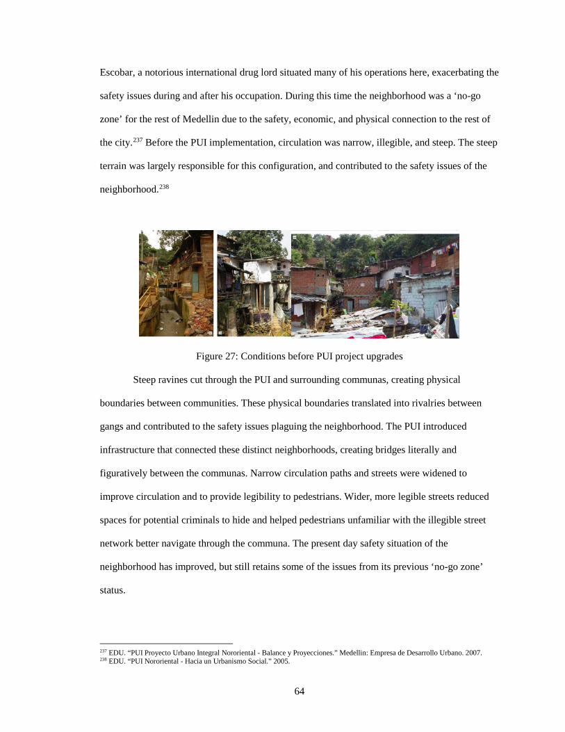
64
Escobar, a notorious international drug lord situated many of his operations here, exacerbating the
safety issues during and after his occupation. During this time the neighborhood was a ‘no-go
zone’ for the rest of Medellin due to the safety, economic, and physical connection to the rest of
the city.237 Before the PUI implementation, circulation was narrow, illegible, and steep. The steep
terrain was largely responsible for this configuration, and contributed to the safety issues of the
neighborhood.238
Figure 27: Conditions before PUI project upgrades
Steep ravines cut through the PUI and surrounding communas, creating physical
boundaries between communities. These physical boundaries translated into rivalries between
gangs and contributed to the safety issues plaguing the neighborhood. The PUI introduced
infrastructure that connected these distinct neighborhoods, creating bridges literally and
figuratively between the communas. Narrow circulation paths and streets were widened to
improve circulation and to provide legibility to pedestrians. Wider, more legible streets reduced
spaces for potential criminals to hide and helped pedestrians unfamiliar with the illegible street
network better navigate through the communa. The present day safety situation of the
neighborhood has improved, but still retains some of the issues from its previous ‘no-go zone’
status.
237 EDU. “PUI Proyecto Urbano Integral Nororiental - Balance y Proyecciones.” Medellin: Empresa de Desarrollo Urbano. 2007. 238 EDU. “PUI Nororiental - Hacia un Urbanismo Social.” 2005.
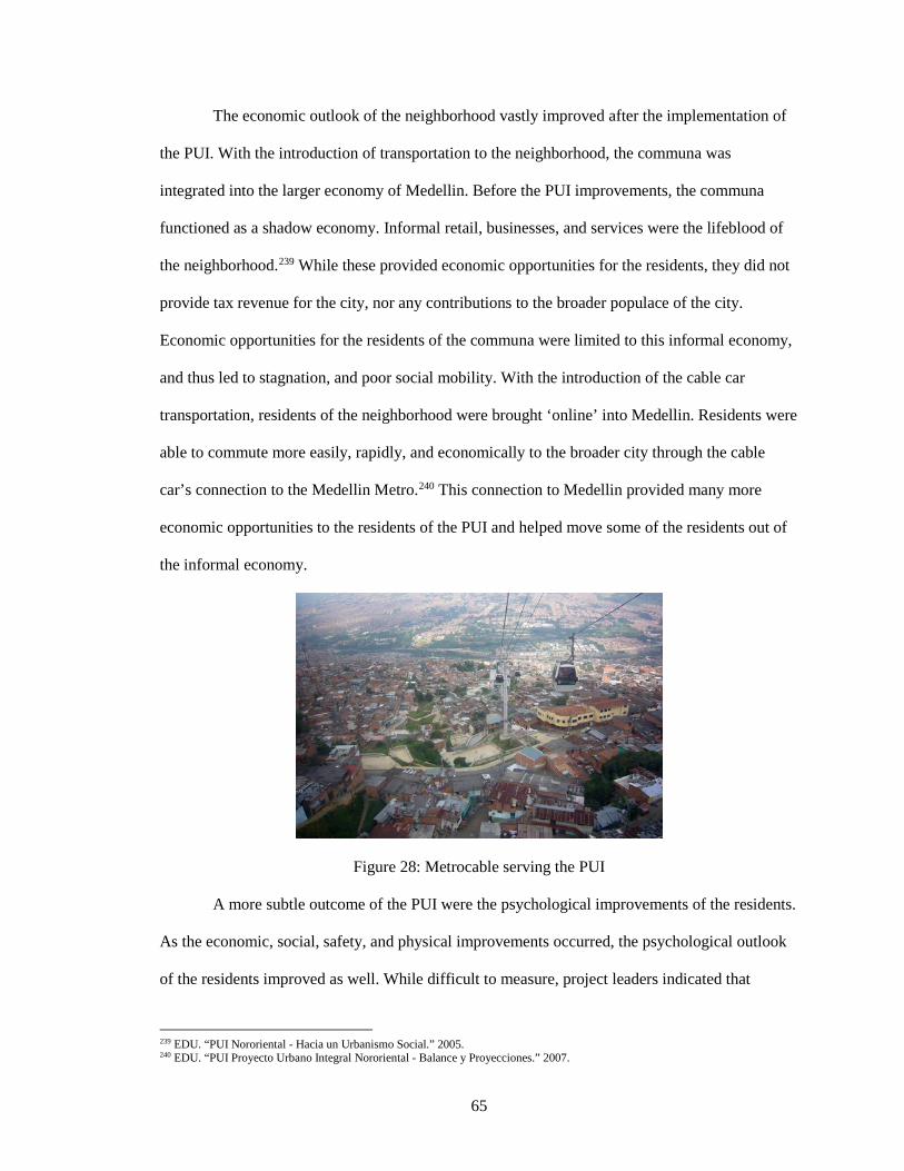
65
The economic outlook of the neighborhood vastly improved after the implementation of
the PUI. With the introduction of transportation to the neighborhood, the communa was
integrated into the larger economy of Medellin. Before the PUI improvements, the communa
functioned as a shadow economy. Informal retail, businesses, and services were the lifeblood of
the neighborhood.239 While these provided economic opportunities for the residents, they did not
provide tax revenue for the city, nor any contributions to the broader populace of the city.
Economic opportunities for the residents of the communa were limited to this informal economy,
and thus led to stagnation, and poor social mobility. With the introduction of the cable car
transportation, residents of the neighborhood were brought ‘online’ into Medellin. Residents were
able to commute more easily, rapidly, and economically to the broader city through the cable
car’s connection to the Medellin Metro.240 This connection to Medellin provided many more
economic opportunities to the residents of the PUI and helped move some of the residents out of
the informal economy.
Figure 28: Metrocable serving the PUI
A more subtle outcome of the PUI were the psychological improvements of the residents.
As the economic, social, safety, and physical improvements occurred, the psychological outlook
of the residents improved as well. While difficult to measure, project leaders indicated that
239 EDU. “PUI Nororiental - Hacia un Urbanismo Social.” 2005. 240 EDU. “PUI Proyecto Urbano Integral Nororiental - Balance y Proyecciones.” 2007.
66
residents had much better outlooks. One of the greatest contributing factors was related to safety.
The past, semi-warlike state of the neighborhood attributed to Pablo Escobar’s connection to the
communa left residents traumatized and trapped. With his expulsion and the PUI improvements,
the community was lifted out of this state of trauma and given opportunities that were previously
unavailable to residents in the broader city of Medellin.241
Echeverri was careful not to attribute all improvements to the PUI, due to the political,
social, and economic changes that were sweeping Medellin in the early 2000s. However, it is
evident the PUI ameliorated the conditions of the communa.242
The Social Urbanism employed in the PUI Nororiental features many components of
“green infrastructure.” Green infrastructure is defined as “an interconnected network of natural
areas and other open spaces that conserves natural ecosystem values and functions, sustains clean
air and water, and provides a wide array of benefits to people and wildlife. Used in this context,
green infrastructure is the ecological framework for environmental, social, and economic health-
in short, our natural life-support system.”243 While the PUI area focused heavily on social factors
and community efforts, there were significant green infrastructure improvements as well. Green
infrastructure works in concert with land development and man-made infrastructure planning to
better lead to land conservation and natural resource protection.244 Because the PUI was
previously developed, it was necessary to introduce green infrastructure that worked alongside
development. Utilizing the hydrological network present in the neighborhood, green corridors
were introduced to the design area using selective demolition and relocation.245
241 EDU. “PUI Proyecto Urbano Integral Nororiental - Balance y Proyecciones.” 2007. 242 IBID 243 Benedict, Mark A. and McMahon, Edward T. “Chapter 1 Why green Infrastructure?” Green Infrastructure: Linking landscapes and Communities. Washington, D.C.: Island Press. 2006. 1-22. 244 IBID 245 EDU. “PUI Nororiental - Hacia un Urbanismo Social.” 2005.
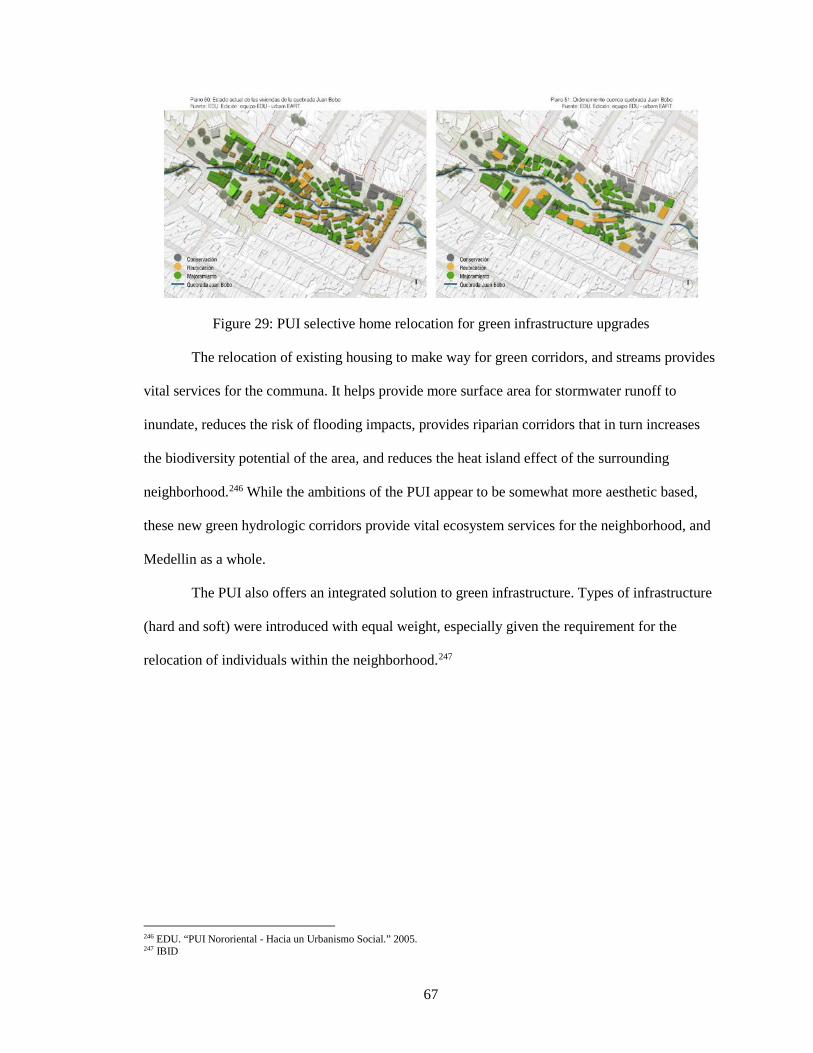
67
Figure 29: PUI selective home relocation for green infrastructure upgrades
The relocation of existing housing to make way for green corridors, and streams provides
vital services for the communa. It helps provide more surface area for stormwater runoff to
inundate, reduces the risk of flooding impacts, provides riparian corridors that in turn increases
the biodiversity potential of the area, and reduces the heat island effect of the surrounding
neighborhood.246 While the ambitions of the PUI appear to be somewhat more aesthetic based,
these new green hydrologic corridors provide vital ecosystem services for the neighborhood, and
Medellin as a whole.
The PUI also offers an integrated solution to green infrastructure. Types of infrastructure
(hard and soft) were introduced with equal weight, especially given the requirement for the
relocation of individuals within the neighborhood.247
246 EDU. “PUI Nororiental - Hacia un Urbanismo Social.” 2005. 247 IBID
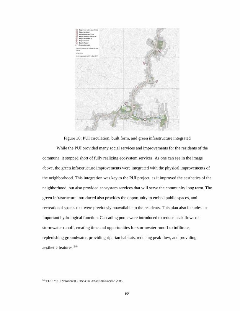
68
Figure 30: PUI circulation, built form, and green infrastructure integrated
While the PUI provided many social services and improvements for the residents of the
communa, it stopped short of fully realizing ecosystem services. As one can see in the image
above, the green infrastructure improvements were integrated with the physical improvements of
the neighborhood. This integration was key to the PUI project, as it improved the aesthetics of the
neighborhood, but also provided ecosystem services that will serve the community long term. The
green infrastructure introduced also provides the opportunity to embed public spaces, and
recreational spaces that were previously unavailable to the residents. This plan also includes an
important hydrological function. Cascading pools were introduced to reduce peak flows of
stormwater runoff, creating time and opportunities for stormwater runoff to infiltrate,
replenishing groundwater, providing riparian habitats, reducing peak flow, and providing
aesthetic features.248
248 EDU. “PUI Nororiental - Hacia un Urbanismo Social.” 2005.
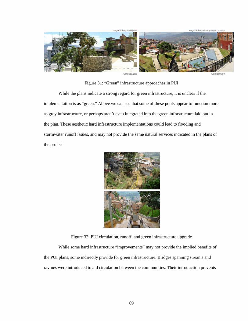
69
Figure 31: “Green” infrastructure approaches in PUI
While the plans indicate a strong regard for green infrastructure, it is unclear if the
implementation is as “green.” Above we can see that some of these pools appear to function more
as grey infrastructure, or perhaps aren’t even integrated into the green infrastructure laid out in
the plan. These aesthetic hard infrastructure implementations could lead to flooding and
stormwater runoff issues, and may not provide the same natural services indicated in the plans of
the project
.
Figure 32: PUI circulation, runoff, and green infrastructure upgrade
While some hard infrastructure “improvements” may not provide the implied benefits of
the PUI plans, some indirectly provide for green infrastructure. Bridges spanning streams and
ravines were introduced to aid circulation between the communities. Their introduction prevents
70
any impacts on the stream and riparian corridor, while also encouraging any future development
higher up the faces of the ravine.249
The PUI Nororiental is clearly successful in its social and sustainability aims. Through a
five phased approach, the community was engaged and consulted at all stages of development.
The development sought to introduce various new physical forms of infrastructure ranging from
roads, footpaths, bridges, cable car, riparian corridors, and streetscape improvements. The project
also effectively introduced institutional infrastructure that will improve and upgrade the
community over time. It is clear that this integrated approach to planning and design is highly
effective in upgrading an existing neighborhood in place, and demonstrates the potential of Social
Urbanism going forward.
6. KIP Successes and Failures
The Kampung Improvement Program (KIP) largely improved the quality of life and
living standards of Indonesian urban slums at a low cost of investment. KIP had an immediate
and positive impact on kampungs where the inputs were directed. Improvements to the kampungs
encouraged residents to invest in home repairs, higher quality architecture, and participate in the
operations and maintenance of community infrastructure.250
The immediate areas surrounding KIP kampungs benefited from the projects as the
physical and economic impacts of KIP expanded into neighboring communities. At the citywide
level, however, environmental conditions deteriorated as rapid population and economic growth
increased demand for urban infrastructure elements like housing, water, sanitation, footpaths,
roads, and drainage. KIP kampungs and their immediate surroundings became islands of
environmental improvements.251
Community consultation and participation in early stages of design was essential to
instilling a sense of ownership and participation for the community. KIP did not provide urban 249 EDU. “PUI Nororiental - Hacia un Urbanismo Social.” 2005. 250 Independent Evaluation Group. “Indonesia- Enhancing the Quality of Life in Urban Indonesia: the Legacy of Kampung Improvement Program.” 2012. Accessed April 2, 2017. 251 IBID
71
mobility, but it promoted tenure and senses of house ownership. KIP's rapid and extensive
implementation may have led to a low level of household turnover and mobility. Residents,
widely aware of KIP’s broad territory across the city, did not feel the need to move in order to
take advantage of the program.252
The rising demand for scarce urban land in major Indonesian cities, especially Jakarta,
will lead to the redevelopment of kampungs into commercial and high-end residential real estate.
Despite KIP’s focus on physical improvements to infrastructure, Urban I-IV did have some
significant and notable impacts on institutional developments in the urban sector of Indonesia.
New agencies and existing institutions were strengthened at the central level.253
KIP provided many lessons for the future of slum upgrading in Jakarta, as well as around
the world. However, several recommendations can be made to ensure future approaches best
address the many Kampungs still present in Jakarta. Future upgrade programs should integrate
flood control measures as well as drainage networks at the citywide scale. Improved drainage
systems helped to reduce flooding with KIP investments and interventions. However, some issues
arose from drainage backlogs at entrances to city drains where backups were common when
drains are not cleared regularly. Any improvements to drainage in one area should not negatively
impact neighboring areas. This issue often arises when the project addresses site specific issues
piecemeal.254
Some aspects of infrastructure and environmental conditions can be managed and
maintained by the communities they serve. Residents and communities can help improve and
manage dwelling conditions, road and footpath maintenance, solid waste collection, and the
upkeep of local drains. The illegal dumping of solid waste, the integration of kampung
infrastructure into city-wide infrastructure, and the effects of pollution, are beyond the control of
252 Independent Evaluation Group. “Indonesia- Enhancing the Quality of Life in Urban Indonesia: the Legacy of Kampung Improvement Program.” 2012 253 IBID 254 IBID
72
communities and require government intervention and management.255
Future urban projects in Indonesia should consider and assess the dynamics of the local
real estate market. Demand for modern real estate development in Indonesia's cities can limit low
income infrastructure improvements to Kampungs in prime locations. The redevelopment of
kampungs is occurring rapidly, indicating future projects should address policy issues relating to
compensation for displaced low income families, as well as their relocation.256
Future projects should promote partnerships with community groups and NGOs as a
means to ensure that they are responsive to kampung needs. The participation of communities and
NGOs at early stages of design should be addressed early in planning stages, due to their
important role instilling a sense of project ownership by the community. Although the concept of
community consultation and participation is now widely accepted, those at the local government
level understand the concept but do not translate it into practice. This signals better guidelines for
community members, NGOs, and project staff should be created.257
It is important to document, monitor, and quantify the successes and failures of such
projects to provide guidance for future endeavors, as well as to facilitate the sharing of knowledge
for these aims worldwide. Steps should be taken to consolidate institutional memory within
government and the World Bank for future projects. An urban development arm of the Indonesian
national government, BAPPENAS, plans to develop an in-house evaluation for all sectors,
including impact evaluations.258
KIP serves as a starting point for the upgrade and formalization of Jakarta’s plentiful
slums. The simple and somewhat rudimentary upgrades it provided helped improve the living
conditions of vast swathes of Jakarta. KIP, however, failed to make upgrades across scales, and
engage and encourage any significant community participation. KIP provides a history and local
255 Independent Evaluation Group. “Indonesia- Enhancing the Quality of Life in Urban Indonesia: the Legacy of Kampung Improvement Program.” 2012. 256 IBID 257 IBID 258 IBID
73
knowledge among Indonesians as to what they can expect from slum improvement projects,
perhaps making them more receptive to proposed projects.
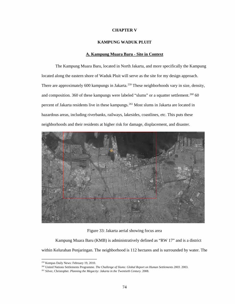
74
CHAPTER V
KAMPUNG WADUK PLUIT
A. Kampung Muara Baru - Site in Context The Kampung Muara Baru, located in North Jakarta, and more specifically the Kampung
located along the eastern shore of Waduk Pluit will serve as the site for my design approach.
There are approximately 600 kampungs in Jakarta.259 These neighborhoods vary in size, density,
and composition. 360 of these kampungs were labeled “slums” or a squatter settlement.260 60
percent of Jakarta residents live in these kampungs.261 Most slums in Jakarta are located in
hazardous areas, including riverbanks, railways, lakesides, coastlines, etc. This puts these
neighborhoods and their residents at higher risk for damage, displacement, and disaster.
Figure 33: Jakarta aerial showing focus area
Kampung Muara Baru (KMB) is administratively defined as “RW 17” and is a district
within Kelurahan Penjaringan. The neighborhood is 112 hectares and is surrounded by water. The
259 Kompas Daily News: February 19, 2010. 260 United Nations Settlements Programme. The Challenge of Slums: Global Report on Human Settlements 2003. 2003. 261 Silver, Christopher. Planning the Megacity: Jakarta in the Twentieth Century. 2008.
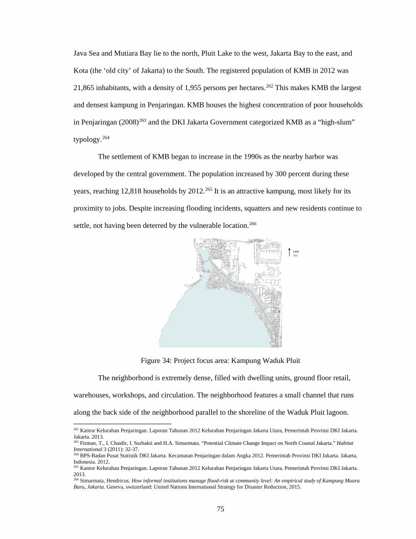
75
Java Sea and Mutiara Bay lie to the north, Pluit Lake to the west, Jakarta Bay to the east, and
Kota (the ‘old city’ of Jakarta) to the South. The registered population of KMB in 2012 was
21,865 inhabitants, with a density of 1,955 persons per hectares.262 This makes KMB the largest
and densest kampung in Penjaringan. KMB houses the highest concentration of poor households
in Penjaringan (2008)263 and the DKI Jakarta Government categorized KMB as a “high-slum”
typology.264
The settlement of KMB began to increase in the 1990s as the nearby harbor was
developed by the central government. The population increased by 300 percent during these
years, reaching 12,818 households by 2012.265 It is an attractive kampung, most likely for its
proximity to jobs. Despite increasing flooding incidents, squatters and new residents continue to
settle, not having been deterred by the vulnerable location.266
Figure 34: Project focus area: Kampung Waduk Pluit
The neighborhood is extremely dense, filled with dwelling units, ground floor retail,
warehouses, workshops, and circulation. The neighborhood features a small channel that runs
along the back side of the neighborhood parallel to the shoreline of the Waduk Pluit lagoon. 262 Kantor Kelurahan Penjaringan. Laporan Tahunan 2012 Kelurahan Penjaringan Jakarta Utara, Pemerintah Provinsi DKI Jakarta. Jakarta. 2013. 263 Firman, T., I. Chaidir, I. Surbakti and H.A. Simarmata. “Potential Climate Change Impact on North Coastal Jakarta.” Habitat International 3 (2011): 32-37. 264 BPS-Badan Pusat Statistik DKI Jakarta. Kecamatan Penjaringan dalam Angka 2012. Pemerintah Provinsi DKI Jakarta. Jakarta, Indonesia. 2012. 265 Kantor Kelurahan Penjaringan. Laporan Tahunan 2012 Kelurahan Penjaringan Jakarta Utara, Pemerintah Provinsi DKI Jakarta. 2013. 266 Simarmata, Hendricus. How informal institutions manage flood-risk at community level: An empirical study of Kampung Muara Baru, Jakarta. Geneva, switzerland: United Nations International Strategy for Disaster Reduction, 2015.
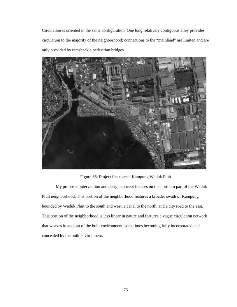
76
Circulation is oriented in the same configuration. One long relatively contiguous alley provides
circulation to the majority of the neighborhood; connections to the “mainland” are limited and are
only provided by ramshackle pedestrian bridges.
Figure 35: Project focus area: Kampung Waduk Pluit
My proposed intervention and design concept focuses on the northern part of the Waduk
Pluit neighborhood. This portion of the neighborhood features a broader swath of Kampung
bounded by Waduk Pluit to the south and west, a canal to the north, and a city road to the east.
This portion of the neighborhood is less linear in nature and features a vague circulation network
that weaves in and out of the built environment, sometimes becoming fully incorporated and
concealed by the built environment.
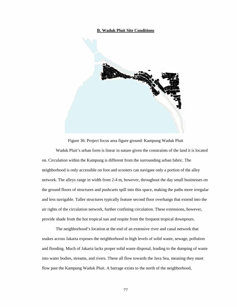
77
B. Waduk Pluit Site Conditions
Figure 36: Project focus area figure ground: Kampung Waduk Pluit
Waduk Pluit’s urban form is linear in nature given the constraints of the land it is located
on. Circulation within the Kampung is different from the surrounding urban fabric. The
neighborhood is only accessible on foot and scooters can navigate only a portion of the alley
network. The alleys range in width from 2-4 m, however, throughout the day small businesses on
the ground floors of structures and pushcarts spill into this space, making the paths more irregular
and less navigable. Taller structures typically feature second floor overhangs that extend into the
air rights of the circulation network, further confining circulation. These extensions, however,
provide shade from the hot tropical sun and respite from the frequent tropical downpours.
The neighborhood’s location at the end of an extensive river and canal network that
snakes across Jakarta exposes the neighborhood to high levels of solid waste, sewage, pollution
and flooding. Much of Jakarta lacks proper solid waste disposal, leading to the dumping of waste
into water bodies, streams, and rivers. These all flow towards the Java Sea, meaning they must
flow past the Kampung Waduk Pluit. A barrage exists to the north of the neighborhood,
78
restricting the flow of solid materials leading to a concentration and backlog of solid waste in
Waduk Pluit. For the same reasons pollution and sewage reach higher concentrations in Waduk
Pluit due to its downstream location, and the poor disposal and treatment options present in the
rest of Jakarta. Solid waste contributes to the flooding experienced in Waduk Pluit as it clogs
drainage systems and canals. Removal efforts are rudimentary, relying on individuals to collect
and ship it away.
Flooding in the neighborhood is caused by several factors. Given the proximity to the
Java Sea, the neighborhood experiences tidal flooding during tidal maximas. While tides do not
influence the water levels within the lagoon, due to a barrage that disconnects and actively
manages the water level of the lagoon independent of the Java Sea, tidal maximas cause
widespread flooding along the coastline, including within Waduk Pluit. Due to land subsidence,
elevations at or slightly below sea level, and an ineffective city drainage and canal system,
Waduk Pluit experiences tidal floods at regular intervals during tidal maximas. Flood events in
Waduk Pluit also occur from runoff during rain events flowing downstream to the Java Sea from
much of the city of Jakarta. A river and canal network facilitates drainage from parts of the city at
higher elevations, but as this runoff reaches the broad coastal plain its flow slows. Water collects
in drainage canals, rivers, and low lying areas, causing flooding during heavy rainfall. Minimal
stormwater treatment and collection also contributes to localized flooding, quickly leading to
impassable roads, sidewalks, and alleys. Jakarta’s rapid urbanization has also led to higher peak
flows during storm events, leading to flash flooding, as permeability has been significantly
reduced over time. As subsidence accelerates due to groundwater extraction, the potential for
flood events and more localized pooling and ponding will increase. The neighborhood of Waduk
Pluit is one of the neighborhoods most impacted by subsidence, experiencing rates of up to 16 cm
per year. Waduk Pluit’s location at the convergence of tidal flood events as well as downstream
floods means the neighborhood is highly susceptible to increasing flooding, and eventually the
possibility of submergence.
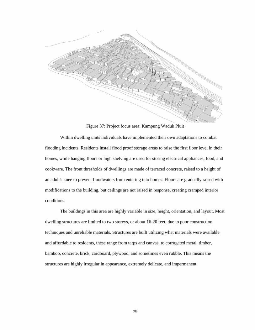
79
Figure 37: Project focus area: Kampung Waduk Pluit
Within dwelling units individuals have implemented their own adaptations to combat
flooding incidents. Residents install flood proof storage areas to raise the first floor level in their
homes, while hanging floors or high shelving are used for storing electrical appliances, food, and
cookware. The front thresholds of dwellings are made of terraced concrete, raised to a height of
an adult's knee to prevent floodwaters from entering into homes. Floors are gradually raised with
modifications to the building, but ceilings are not raised in response, creating cramped interior
conditions.
The buildings in this area are highly variable in size, height, orientation, and layout. Most
dwelling structures are limited to two storeys, or about 16-20 feet, due to poor construction
techniques and unreliable materials. Structures are built utilizing what materials were available
and affordable to residents, these range from tarps and canvas, to corrugated metal, timber,
bamboo, concrete, brick, cardboard, plywood, and sometimes even rubble. This means the
structures are highly irregular in appearance, extremely delicate, and impermanent.
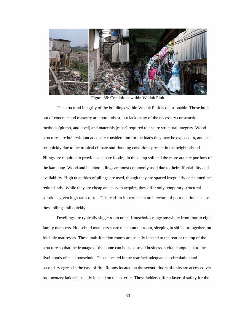
80
Figure 38: Conditions within Waduk Pluit
The structural integrity of the buildings within Waduk Pluit is questionable. Those built
out of concrete and masonry are more robust, but lack many of the necessary construction
methods (plumb, and level) and materials (rebar) required to ensure structural integrity. Wood
structures are built without adequate consideration for the loads they may be exposed to, and can
rot quickly due to the tropical climate and flooding conditions present in the neighborhood.
Pilings are required to provide adequate footing in the damp soil and the more aquatic portions of
the kampung. Wood and bamboo pilings are most commonly used due to their affordability and
availability. High quantities of pilings are used, though they are spaced irregularly and sometimes
redundantly. While they are cheap and easy to acquire, they offer only temporary structural
solutions given high rates of rot. This leads to impermanent architecture of poor quality because
these pilings fail quickly.
Dwellings are typically single room units. Households range anywhere from four to eight
family members. Household members share the common room, sleeping in shifts, or together, on
foldable mattresses. These multifunction rooms are usually located to the rear or the top of the
structure so that the frontage of the home can house a small business, a vital component to the
livelihoods of each household. Those located in the rear lack adequate air circulation and
secondary egress in the case of fire. Rooms located on the second floors of units are accessed via
rudimentary ladders, usually located on the exterior. These ladders offer a layer of safety for the
81
residents since they can be removed to protect the individuals and belongings within. Doors are
common, but windows are atypical due to the expense of glass.
Most dwellings have no running or potable water, meaning water has to be transported
into the neighborhood via push cart (due to the lack of vehicular circulation). Cooking fuel ranges
from woody biomass/debris, to kerosene tanks that are brought in via pushcart. The open flames
of these cooking fuels expose these (already unsafe) structures to high fire risk, and explains the
frequent fires that destroy portions of the neighborhood.
Sanitation is limited in the neighborhood as well. Squat toilets have been fitted in the
households with greater economic resources, but much of the neighborhood relies on buckets as
makeshift toilets. Since sewers are not present in the neighborhood, buckets and toilets with
rudimentary plumbing are emptying directly into the lagoon or canal. Solid waste (trash) is either
burned or dumped into adjacent water bodies, creating piles of trash throughout the
neighborhood.
Electricity is present in the neighborhood, but widescale availability and adoption is
limited due to associated costs and limited infrastructure deep within the Kampung. It is unclear if
the electricity that is present in some dwellings is distributed by electric companies, or hijacked.
Waduk Pluit inhabitants rely largely on an informal economy that is confined largely to
the neighborhood itself, but extends beyond for employment. Most households maintain a small
business in their dwelling that may include a small convenience store, restaurant, warehousing
function, or workshop. These businesses primarily employ household members and provide
income to the household. Employment is also available in the surrounding waterfront area where
shipping, fishing, warehousing, and transport are common businesses. This proximity has
promoted the development and density of Waduk Pluit due to the difficulty of navigating and
commuting within Jakarta. This is the most substantial connection Waduk Pluit has to the broader
Jakarta economy, and Jakarta at large. Otherwise, Waduk Pluit lies in relative isolation due to its
separation from most essential infrastructure and transportation networks.
82
The conditions listed above highlight the complex and compounding issues facing
residents in Waduk Pluit. Left to their own devices, residents have found inventive and adaptive
methods to address the numerous issues present. However, the outlook, conditions, and quality of
life of the slum could be vastly improved with the provision of vital infrastructure, quality
architecture, and resilient design. Given the limited financial resources of residents, NGOs, and
government, any upgrades to the kampung must be “least-case,” rather than “best-case” options.
Projects must provide the most essential services and infrastructure with minimal cost and
interventions. It should also be noted that the formalization of this neighborhood can contribute
greatly to the economy of Jakarta as a whole, whereas if this kampung were slated for demolition,
as is the common practice in Jakarta, any investment would remain with developers and those
already with financial means.
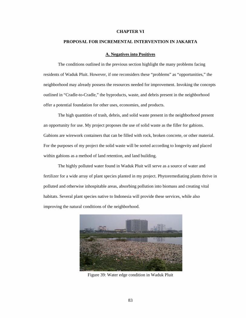
83
CHAPTER VI
PROPOSAL FOR INCREMENTAL INTERVENTION IN JAKARTA
A. Negatives into Positives
The conditions outlined in the previous section highlight the many problems facing
residents of Waduk Pluit. However, if one reconsiders these “problems” as “opportunities,” the
neighborhood may already possess the resources needed for improvement. Invoking the concepts
outlined in “Cradle-to-Cradle,” the byproducts, waste, and debris present in the neighborhood
offer a potential foundation for other uses, economies, and products.
The high quantities of trash, debris, and solid waste present in the neighborhood present
an opportunity for use. My project proposes the use of solid waste as the filler for gabions.
Gabions are wirework containers that can be filled with rock, broken concrete, or other material.
For the purposes of my project the solid waste will be sorted according to longevity and placed
within gabions as a method of land retention, and land building.
The highly polluted water found in Waduk Pluit will serve as a source of water and
fertilizer for a wide array of plant species planted in my project. Phytoremediating plants thrive in
polluted and otherwise inhospitable areas, absorbing pollution into biomass and creating vital
habitats. Several plant species native to Indonesia will provide these services, while also
improving the natural conditions of the neighborhood.
Figure 39: Water edge condition in Waduk Pluit
84
Human waste is a major problem within Waduk Pluit. Residents will be provided with
composting toilets for each household, allowing the waste to be converted into valuable compost.
This compost can then provide the nutrients and soil necessary for the growth of food within a
small rooftop garden located on each structure. The roof will also feature a butterfly design for
the collection of the heavy and frequent tropical downpours. This roof shape will help collect
rainwater for filtration into potable drinking water for the residents of each dwelling unit.
As my project matures and the financial means of residents improve, solar panels will be
made available at low cost to generate electricity. These panels will be able to convert the bright
tropical sunlight into energy for cooking, lighting, electronics, and appliances. Given Jakarta’s
location near the equator, the orientation of the solar panels is more flexible, giving the potential
for widespread implementation.
Each of these approaches utilizes the natural resources, byproducts, or discarded
materials present in Waduk Pluit and converts them into useful products and resources for the
neighborhood. Each approach was evaluated to ensure affordability, ease of implementation, and
usefulness. An effort was also made to use methods and resources that were independent from
external infrastructure, helping the neighborhood function without input from government or
external organizations, and giving residents the ability to take ownership for upgrading their
residences and neighborhood.
B. Independent Infrastructure
As outlined previously, independent infrastructure plays an important role in my project
for the provision of essential utilities and resources for the residents of Waduk Pluit. Independent
infrastructure refers to services and utilities independent and discrete from those provided by
government and corporations and is essential for habitation and quality of life.
My project will employ independent infrastructure to provide potable water, electricity,
sanitation, cooking fuel, phytoremediation, and solid waste disposal. Independent infrastructure
gives residents with the opportunity to elect which resources and utilities are most essential to
85
their needs, while providing the opportunity for future upgrade with minimal intrusion. Current
forms of infrastructure rely on networks of permanent pipes, wires, roads, and sewers. Taking
lessons from Brand, these forms of static and unchangeable infrastructure within architecture
limit adaptability, modification, and changing programs and needs. For residents of Waduk Pluit
independent infrastructure will remove these utilities and services from hard infrastructure and
provide a means for future upgrades independent of broader static infrastructure.
Independent infrastructure will allow for the provision of utilities and services
independent from local and national government entities. Given the weak and corrupt nature of
government in Indonesia and Jakarta, and the isolated and anarchic nature of Kampungs,
independent infrastructure will enable residents to play an active role in the provision of
infrastructure independent of these entities. This type of infrastructure can also be appealing to
government, NGOs, and utility companies, allowing for minimal financial investments to be
made in hard infrastructure into dense unplanned neighborhoods, while providing the same
services. Independent infrastructure and utilities will also enable residents to reduce long-term
costs of utilities, while also producing products and benefits in many cases.
C. Kit-of-Parts
My project will employ a “kit of parts” method for the production of new dwelling units.
My kit comprises components readily available in Waduk Pluit, and can be assembled simply to
create a core structure from which future incremental architectural additions may occur. The same
kit of parts approach is also part of the design for the landscape and urban design of my project.
The architectural kit of parts comprises: rubble and trash filled gabions used as a pad for
construction; steel screw piles, capable of being driven into the earth by hand, will provide a
stable footing for the dwelling; bamboo structural members will be lashed together forming the
framework and structure for the dwelling unit; woven bamboo fibers will provide walls for the
unit; concrete blocks will make up a vertical core that provides support for heavier components;
pallets will be inserted into the bamboo structure providing the flooring and ceiling for the
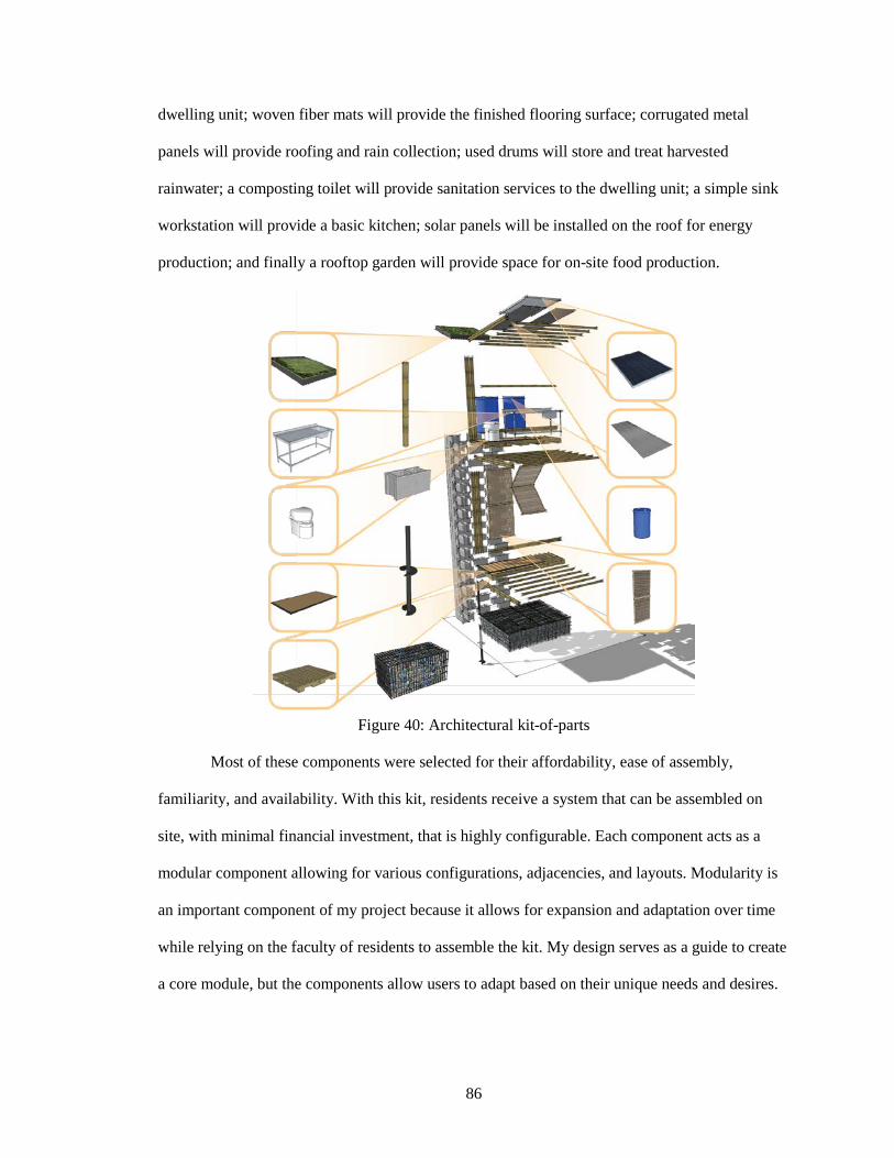
86
dwelling unit; woven fiber mats will provide the finished flooring surface; corrugated metal
panels will provide roofing and rain collection; used drums will store and treat harvested
rainwater; a composting toilet will provide sanitation services to the dwelling unit; a simple sink
workstation will provide a basic kitchen; solar panels will be installed on the roof for energy
production; and finally a rooftop garden will provide space for on-site food production.
Figure 40: Architectural kit-of-parts
Most of these components were selected for their affordability, ease of assembly,
familiarity, and availability. With this kit, residents receive a system that can be assembled on
site, with minimal financial investment, that is highly configurable. Each component acts as a
modular component allowing for various configurations, adjacencies, and layouts. Modularity is
an important component of my project because it allows for expansion and adaptation over time
while relying on the faculty of residents to assemble the kit. My design serves as a guide to create
a core module, but the components allow users to adapt based on their unique needs and desires.
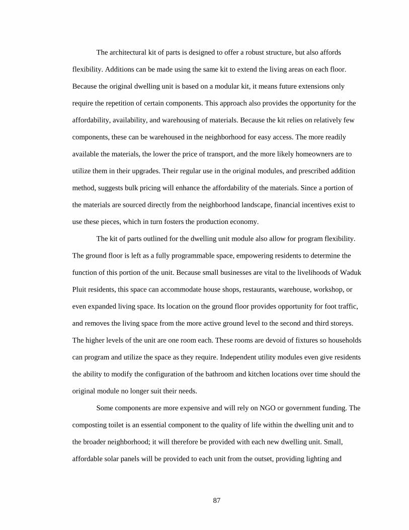
87
The architectural kit of parts is designed to offer a robust structure, but also affords
flexibility. Additions can be made using the same kit to extend the living areas on each floor.
Because the original dwelling unit is based on a modular kit, it means future extensions only
require the repetition of certain components. This approach also provides the opportunity for the
affordability, availability, and warehousing of materials. Because the kit relies on relatively few
components, these can be warehoused in the neighborhood for easy access. The more readily
available the materials, the lower the price of transport, and the more likely homeowners are to
utilize them in their upgrades. Their regular use in the original modules, and prescribed addition
method, suggests bulk pricing will enhance the affordability of the materials. Since a portion of
the materials are sourced directly from the neighborhood landscape, financial incentives exist to
use these pieces, which in turn fosters the production economy.
The kit of parts outlined for the dwelling unit module also allow for program flexibility.
The ground floor is left as a fully programmable space, empowering residents to determine the
function of this portion of the unit. Because small businesses are vital to the livelihoods of Waduk
Pluit residents, this space can accommodate house shops, restaurants, warehouse, workshop, or
even expanded living space. Its location on the ground floor provides opportunity for foot traffic,
and removes the living space from the more active ground level to the second and third storeys.
The higher levels of the unit are one room each. These rooms are devoid of fixtures so households
can program and utilize the space as they require. Independent utility modules even give residents
the ability to modify the configuration of the bathroom and kitchen locations over time should the
original module no longer suit their needs.
Some components are more expensive and will rely on NGO or government funding. The
composting toilet is an essential component to the quality of life within the dwelling unit and to
the broader neighborhood; it will therefore be provided with each new dwelling unit. Small,
affordable solar panels will be provided to each unit from the outset, providing lighting and
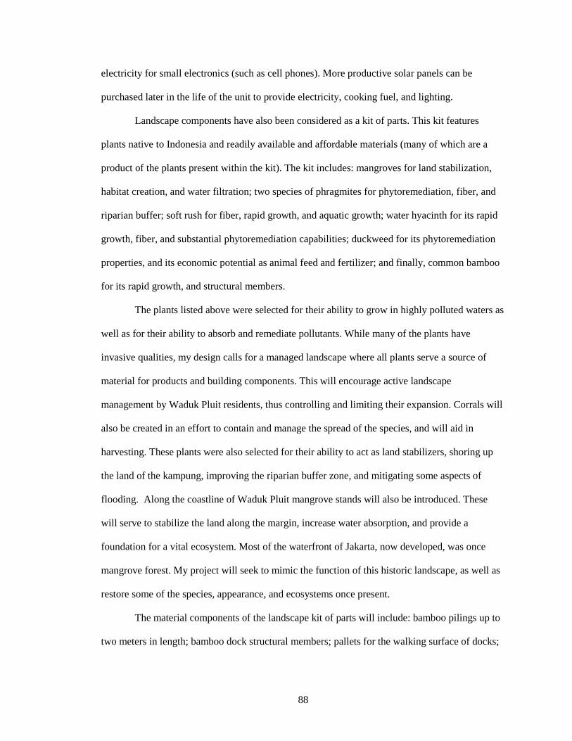
88
electricity for small electronics (such as cell phones). More productive solar panels can be
purchased later in the life of the unit to provide electricity, cooking fuel, and lighting.
Landscape components have also been considered as a kit of parts. This kit features
plants native to Indonesia and readily available and affordable materials (many of which are a
product of the plants present within the kit). The kit includes: mangroves for land stabilization,
habitat creation, and water filtration; two species of phragmites for phytoremediation, fiber, and
riparian buffer; soft rush for fiber, rapid growth, and aquatic growth; water hyacinth for its rapid
growth, fiber, and substantial phytoremediation capabilities; duckweed for its phytoremediation
properties, and its economic potential as animal feed and fertilizer; and finally, common bamboo
for its rapid growth, and structural members.
The plants listed above were selected for their ability to grow in highly polluted waters as
well as for their ability to absorb and remediate pollutants. While many of the plants have
invasive qualities, my design calls for a managed landscape where all plants serve a source of
material for products and building components. This will encourage active landscape
management by Waduk Pluit residents, thus controlling and limiting their expansion. Corrals will
also be created in an effort to contain and manage the spread of the species, and will aid in
harvesting. These plants were also selected for their ability to act as land stabilizers, shoring up
the land of the kampung, improving the riparian buffer zone, and mitigating some aspects of
flooding. Along the coastline of Waduk Pluit mangrove stands will also be introduced. These
will serve to stabilize the land along the margin, increase water absorption, and provide a
foundation for a vital ecosystem. Most of the waterfront of Jakarta, now developed, was once
mangrove forest. My project will seek to mimic the function of this historic landscape, as well as
restore some of the species, appearance, and ecosystems once present.
The material components of the landscape kit of parts will include: bamboo pilings up to
two meters in length; bamboo dock structural members; pallets for the walking surface of docks;
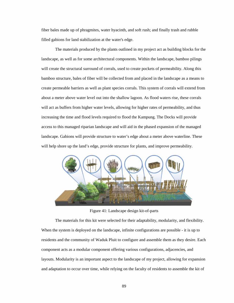
89
fiber bales made up of phragmites, water hyacinth, and soft rush; and finally trash and rubble
filled gabions for land stabilization at the water's edge.
The materials produced by the plants outlined in my project act as building blocks for the
landscape, as well as for some architectural components. Within the landscape, bamboo pilings
will create the structural surround of corrals, used to create pockets of permeability. Along this
bamboo structure, bales of fiber will be collected from and placed in the landscape as a means to
create permeable barriers as well as plant species corrals. This system of corrals will extend from
about a meter above water level out into the shallow lagoon. As flood waters rise, these corrals
will act as buffers from higher water levels, allowing for higher rates of permeability, and thus
increasing the time and flood levels required to flood the Kampung. The Docks will provide
access to this managed riparian landscape and will aid in the phased expansion of the managed
landscape. Gabions will provide structure to water’s edge about a meter above waterline. These
will help shore up the land’s edge, provide structure for plants, and improve permeability.
Figure 41: Landscape design kit-of-parts
The materials for this kit were selected for their adaptability, modularity, and flexibility.
When the system is deployed on the landscape, infinite configurations are possible - it is up to
residents and the community of Waduk Pluit to configure and assemble them as they desire. Each
component acts as a modular component offering various configurations, adjacencies, and
layouts. Modularity is an important aspect to the landscape of my project, allowing for expansion
and adaptation to occur over time, while relying on the faculty of residents to assemble the kit of
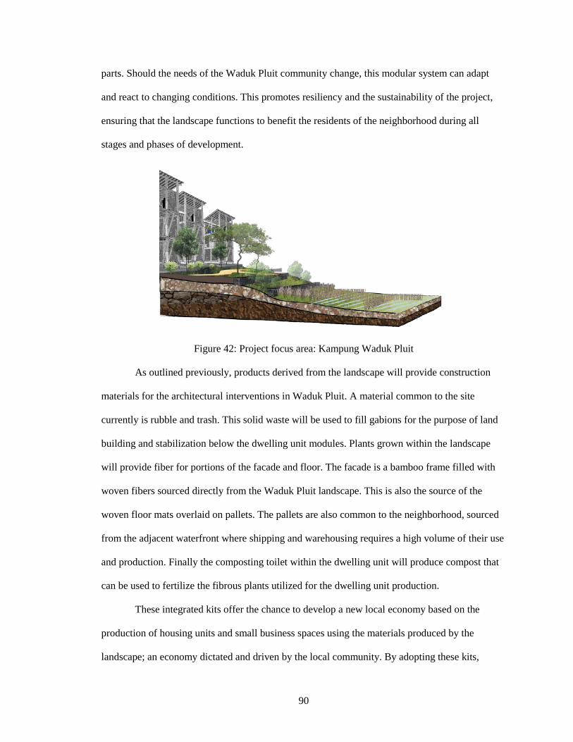
90
parts. Should the needs of the Waduk Pluit community change, this modular system can adapt
and react to changing conditions. This promotes resiliency and the sustainability of the project,
ensuring that the landscape functions to benefit the residents of the neighborhood during all
stages and phases of development.
Figure 42: Project focus area: Kampung Waduk Pluit
As outlined previously, products derived from the landscape will provide construction
materials for the architectural interventions in Waduk Pluit. A material common to the site
currently is rubble and trash. This solid waste will be used to fill gabions for the purpose of land
building and stabilization below the dwelling unit modules. Plants grown within the landscape
will provide fiber for portions of the facade and floor. The facade is a bamboo frame filled with
woven fibers sourced directly from the Waduk Pluit landscape. This is also the source of the
woven floor mats overlaid on pallets. The pallets are also common to the neighborhood, sourced
from the adjacent waterfront where shipping and warehousing requires a high volume of their use
and production. Finally the composting toilet within the dwelling unit will produce compost that
can be used to fertilize the fibrous plants utilized for the dwelling unit production.
These integrated kits offer the chance to develop a new local economy based on the
production of housing units and small business spaces using the materials produced by the
landscape; an economy dictated and driven by the local community. By adopting these kits,
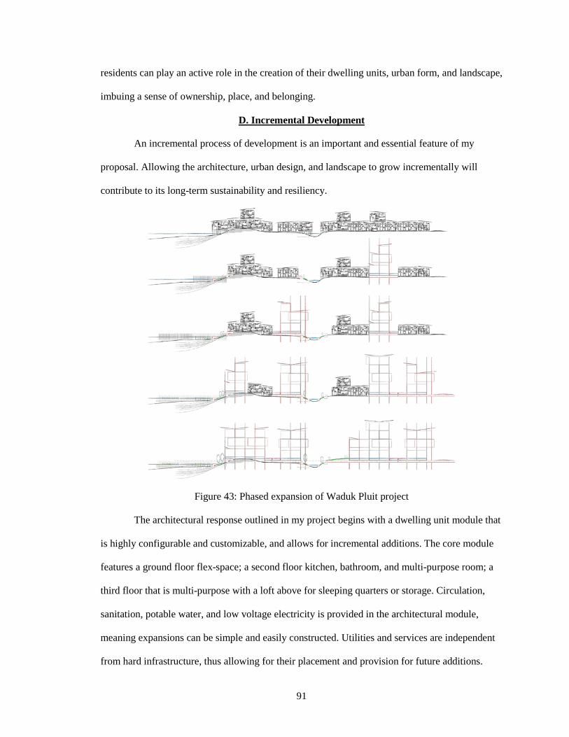
91
residents can play an active role in the creation of their dwelling units, urban form, and landscape,
imbuing a sense of ownership, place, and belonging.
D. Incremental Development
An incremental process of development is an important and essential feature of my
proposal. Allowing the architecture, urban design, and landscape to grow incrementally will
contribute to its long-term sustainability and resiliency.
Figure 43: Phased expansion of Waduk Pluit project
The architectural response outlined in my project begins with a dwelling unit module that
is highly configurable and customizable, and allows for incremental additions. The core module
features a ground floor flex-space; a second floor kitchen, bathroom, and multi-purpose room; a
third floor that is multi-purpose with a loft above for sleeping quarters or storage. Circulation,
sanitation, potable water, and low voltage electricity is provided in the architectural module,
meaning expansions can be simple and easily constructed. Utilities and services are independent
from hard infrastructure, thus allowing for their placement and provision for future additions.
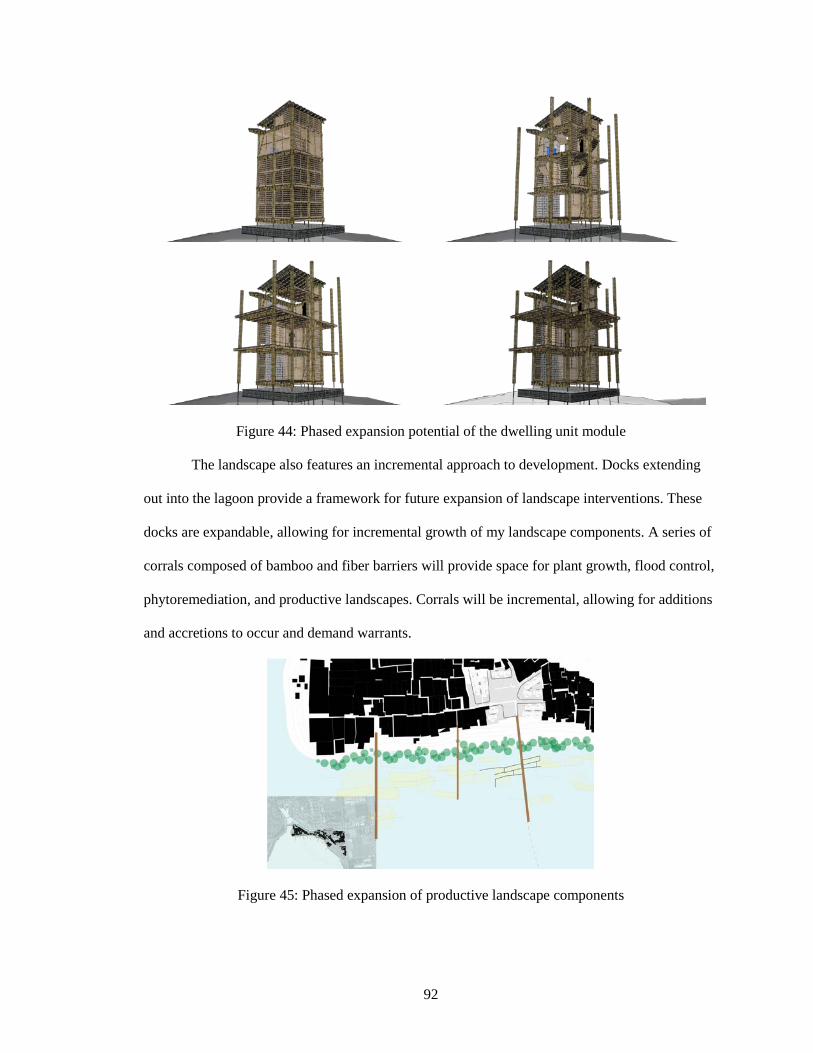
92
Figure 44: Phased expansion potential of the dwelling unit module
The landscape also features an incremental approach to development. Docks extending
out into the lagoon provide a framework for future expansion of landscape interventions. These
docks are expandable, allowing for incremental growth of my landscape components. A series of
corrals composed of bamboo and fiber barriers will provide space for plant growth, flood control,
phytoremediation, and productive landscapes. Corrals will be incremental, allowing for additions
and accretions to occur and demand warrants.
Figure 45: Phased expansion of productive landscape components
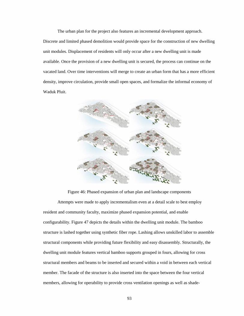
93
The urban plan for the project also features an incremental development approach.
Discrete and limited phased demolition would provide space for the construction of new dwelling
unit modules. Displacement of residents will only occur after a new dwelling unit is made
available. Once the provision of a new dwelling unit is secured, the process can continue on the
vacated land. Over time interventions will merge to create an urban form that has a more efficient
density, improve circulation, provide small open spaces, and formalize the informal economy of
Waduk Pluit.
Figure 46: Phased expansion of urban plan and landscape components
Attempts were made to apply incrementalism even at a detail scale to best employ
resident and community faculty, maximize phased expansion potential, and enable
configurability. Figure 47 depicts the details within the dwelling unit module. The bamboo
structure is lashed together using synthetic fiber rope. Lashing allows unskilled labor to assemble
structural components while providing future flexibility and easy disassembly. Structurally, the
dwelling unit module features vertical bamboo supports grouped in fours, allowing for cross
structural members and beams to be inserted and secured within a void in between each vertical
member. The facade of the structure is also inserted into the space between the four vertical
members, allowing for operability to provide cross ventilation openings as well as shade-
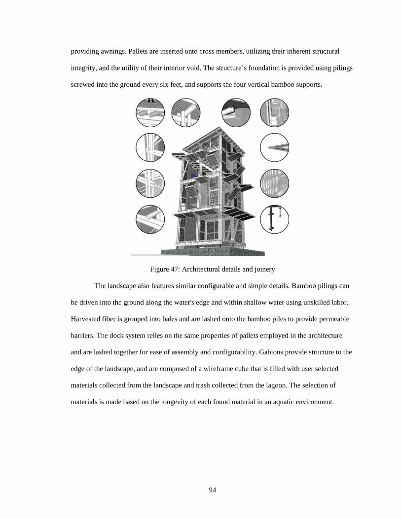
94
providing awnings. Pallets are inserted onto cross members, utilizing their inherent structural
integrity, and the utility of their interior void. The structure’s foundation is provided using pilings
screwed into the ground every six feet, and supports the four vertical bamboo supports.
Figure 47: Architectural details and joinery
The landscape also features similar configurable and simple details. Bamboo pilings can
be driven into the ground along the water's edge and within shallow water using unskilled labor.
Harvested fiber is grouped into bales and are lashed onto the bamboo piles to provide permeable
barriers. The dock system relies on the same properties of pallets employed in the architecture
and are lashed together for ease of assembly and configurability. Gabions provide structure to the
edge of the landscape, and are composed of a wireframe cube that is filled with user selected
materials collected from the landscape and trash collected from the lagoon. The selection of
materials is made based on the longevity of each found material in an aquatic environment.
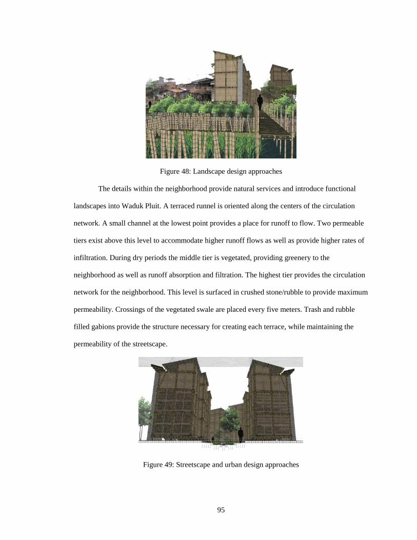
95
Figure 48: Landscape design approaches
The details within the neighborhood provide natural services and introduce functional
landscapes into Waduk Pluit. A terraced runnel is oriented along the centers of the circulation
network. A small channel at the lowest point provides a place for runoff to flow. Two permeable
tiers exist above this level to accommodate higher runoff flows as well as provide higher rates of
infiltration. During dry periods the middle tier is vegetated, providing greenery to the
neighborhood as well as runoff absorption and filtration. The highest tier provides the circulation
network for the neighborhood. This level is surfaced in crushed stone/rubble to provide maximum
permeability. Crossings of the vegetated swale are placed every five meters. Trash and rubble
filled gabions provide the structure necessary for creating each terrace, while maintaining the
permeability of the streetscape.
Figure 49: Streetscape and urban design approaches
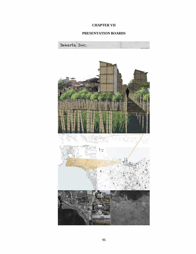
96
CHAPTER VII PRESENTATION BOARDS

97
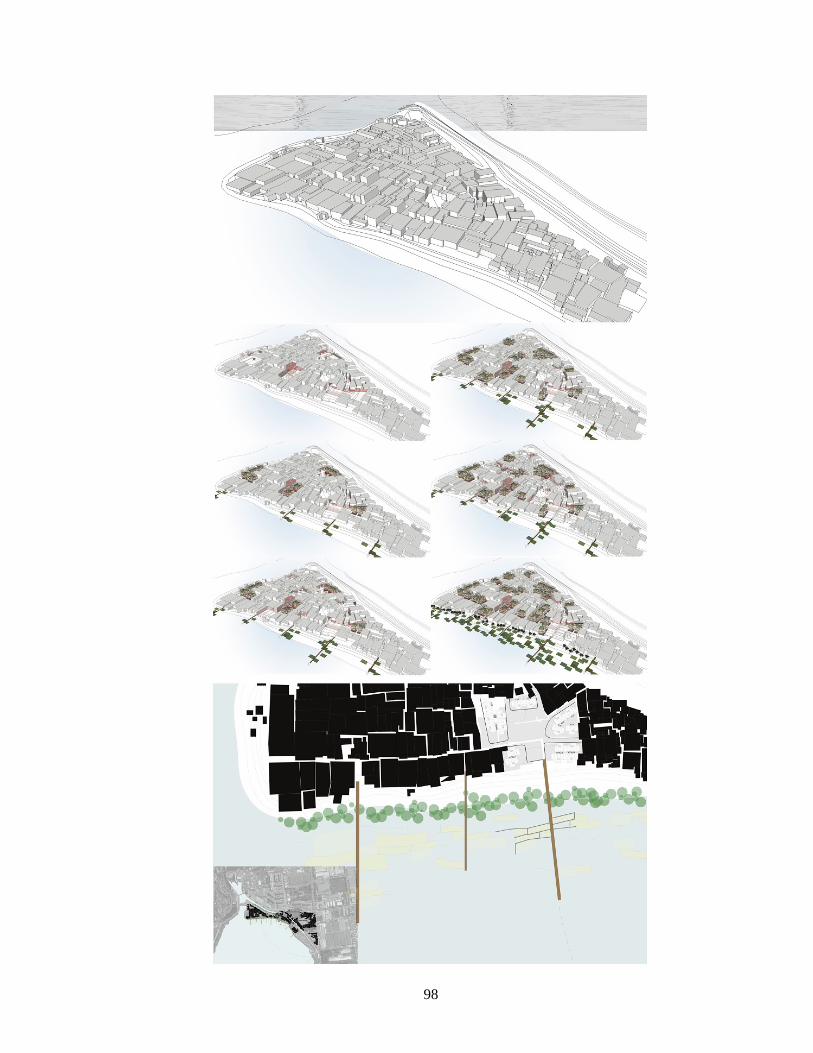
98
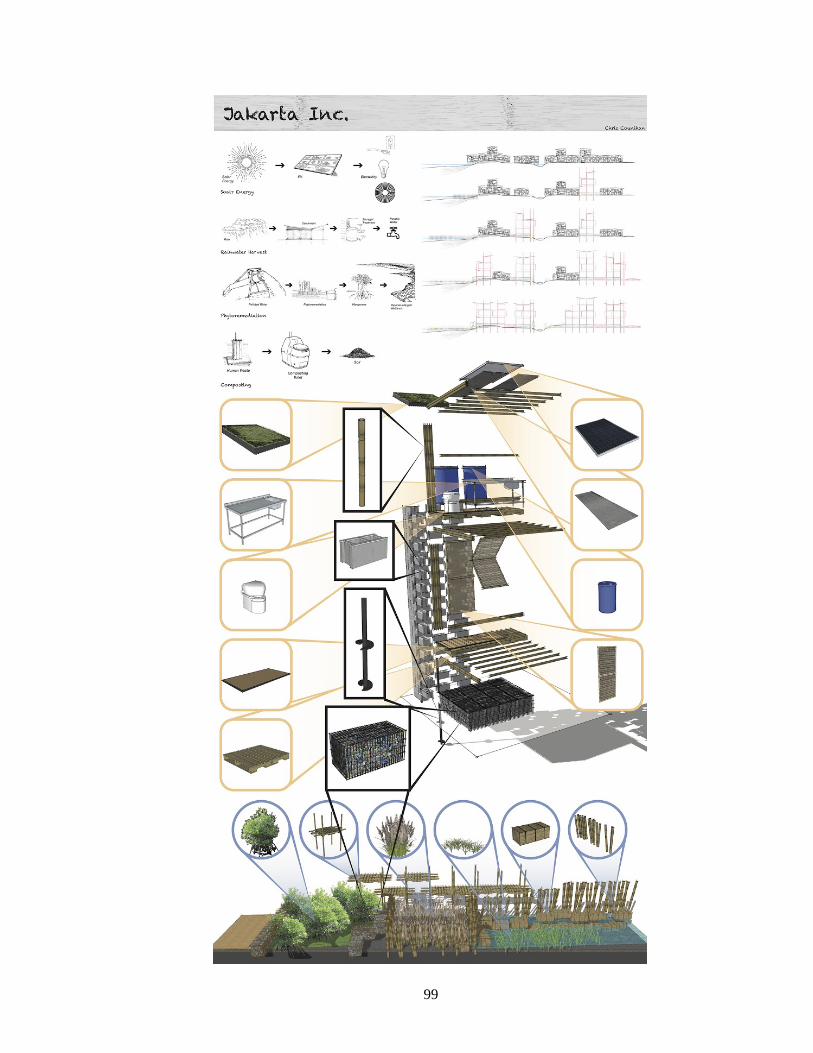
99
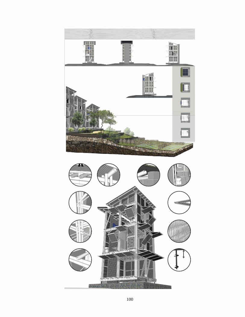
100
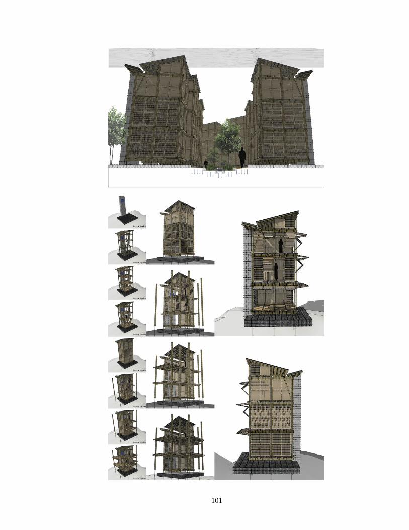
101
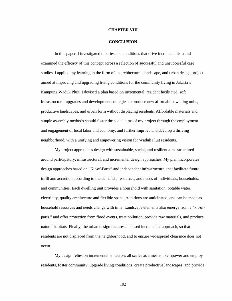
102
CHAPTER VIII
CONCLUSION In this paper, I investigated theories and conditions that drive incrementalism and
examined the efficacy of this concept across a selection of successful and unsuccessful case
studies. I applied my learning in the form of an architectural, landscape, and urban design project
aimed at improving and upgrading living conditions for the community living in Jakarta’s
Kampung Waduk Pluit. I devised a plan based on incremental, resident facilitated, soft
infrastructural upgrades and development strategies to produce new affordable dwelling units,
productive landscapes, and urban form without displacing residents. Affordable materials and
simple assembly methods should foster the social aims of my project through the employment
and engagement of local labor and economy, and further improve and develop a thriving
neighborhood, with a unifying and empowering vision for Waduk Pluit residents.
My project approaches design with sustainable, social, and resilient aims structured
around participatory, infrastructural, and incremental design approaches. My plan incorporates
design approaches based on “Kit-of-Parts” and independent infrastructure, that facilitate future
infill and accretion according to the demands, resources, and needs of individuals, households,
and communities. Each dwelling unit provides a household with sanitation, potable water,
electricity, quality architecture and flexible space. Additions are anticipated, and can be made as
household resources and needs change with time. Landscape elements also emerge from a “kit-of-
parts,” and offer protection from flood events, treat pollution, provide raw materials, and produce
natural habitats. Finally, the urban design features a phased incremental approach, so that
residents are not displaced from the neighborhood, and to ensure widespread clearance does not
occur.
My design relies on incrementalism across all scales as a means to empower and employ
residents, foster community, upgrade living conditions, create productive landscapes, and provide

103
natural services. Due to the incremental nature of my project, as time passes, each service and
provision contributed by my design will grow and strengthen as individuals and communities
become directly engaged in shaping, constructing, and maintaining Waduk Pluit.
104
BIBLIOGRAPHY Abidin, H.Z.; Andreas, H.; Gumilar, I.; and Brinkman, J.J. “Study on the risk and impacts of land subsidence in Jakarta.” Proceedings of the International Association of Hydrological Sciences 372 (2015): 115-120. Abidin, H. Z., Andreas, H., Gumilar, I., Fukuda, Y., Pohan, Y. E., and Deguchi, T. “Land subsidence of Jakarta (Indonesia) and its relation with urban development.” Natural Hazards 59 (2011): 1753–1771. Alberti, Marina. “Chapter 1: The Urban Ecosystem” in Advances in Urban Ecology. New York: Springer. 2008. 1-26. Alcaldia de Medellin. Proyecto Urbano Integral en la Zona Noroiental de Medellin. Medellin: Alcaldia de Medellin. 2007. Alcamo, Serena; Bosco, Daniel; and Federighi, Valeria. “Incremental Open Spaces: The Case of Bharavi, India.” Journal of Design Strategies 6 (2013). http://sds.parsons.edu/designdialogues/?post_type=article&p=190 Angelidou, Ioanna and Yatsuka, Hajime. “Metabolism and After: A Correspondence with Hajime Yatsuka.” Log 24 Architecture Criticism (Winter/Spring 2012): 33–41. http://www.jstor.org/stable/41765464 “Aranya Community Housing.” In Architecture Beyond Architecture, edited by Cynthia C. Davidson and Ismaïl Serageldin. London: Academy Editions, 1995. Aravena, Alejandro. “Elemental-Interview.” Perspecta 42 (2010): 85-89. Aravena Mori, Alejandro and Andrés Iacobelli. Elemental: Incremental housing and participatory design manual. Ostfildern: Hatje Cantz Verlag. 2016. Architectural Review. “AR Special issue: recent work in Colombia ‘How architecture is healing the public realm. A tale of two cities – Bogotá and Medellín.’” CCXXIX, 1368. 2011. Arifin, Zainal. Local Millennium Ecosystem Assessment: Condition and trend of the greater Jakarta Bay Ecosystem. Jakarta: The Ministry of Environment, 2004. Arroyo, Ivette. Organized self-help housing as an enabling shelter & development strategy. Lessons from current practice, institutional approaches and projects in developing countries. Licentiate thesis, Lund University, 2013.
ARUP. Cities Alive: Rethinking Green Infrastructure. London: ARUP. 2014. http://www.arup.com/Homepage_Cities_Alive.aspx Asada, Akira. "Beyond the Biomorphic.” In Tokyo Bay Experiment/Emerging Complexities Symposium, Columbia University, Graduate School of Architecture, Planning and Preservation, New York, 1994.
105
Badan Meterologi dan Geo sika, Ciliwung Cisadane Project and Tempo. Adapted from Pauline Texier, “Floods in Jakarta: when the extreme reveals daily structural constraints and mismanagement.” Disaster Prevention and Management 17, no. 3 (2007). Baker, Judy L. Urban Poverty: A Global View. Washington, D.C.: The World Bank. 2008. Basler, Barbara. "The Walled City, Home to Huddled Masses, Falls". The New York Times. p. A4. June 16, 1992. Retrieved 27 November 2009. Beame, Susie. "Cradle to Grave vs Cradle to Cradle." Design Industry 2009. January 01, 1970. Benedict, Mark A. and McMahon, Edward T. “Chapter 1 Why green Infrastructure?” Green Infrastructure: Linking landscapes and Communities. Washington, D.C.: Island Press. 2006. 1-22. Berger, Allan. “Drosscape.” In The Landscape Urbanism Reader. Ed. Charles Waldheim, Ed. New York: Princeton University Press. 2006. 197-217. Berita Resmi Statistik Provinsi DKI Jakarta No. 21/07/31/Th. XII. July 1, 2010. BID. Medellin - Transformacion de una ciudad. Medellin: BID - Banco Interoamericano de Desarrollo, Alcaldia de Medellin. 2009. Bijutsukan, Mori and Shinbunsha, Nihon Keizai. Metaborizumu no mirai toshi = Metabolism, the city of the future. Tōkyō: Shinkenchikusha. 2011. Blanco, C. and Kobayashi, H. “Urban transformation in slum districts through public space generation and cable transportation at north-eastern area: Medellín, Colombia.” Journal of International Social Research 2, no.8 (2009): 75-90. BPN Departments of North, South, East, West and Central Jakarta Municipalities. BPS-Badan Pusat Statistik DKI Jakarta. Kecamatan Penjaringan dalam Angka 2012. Pemerintah Provinsi DKI Jakarta. Jakarta, Indonesia. 2012. BPS Jakarta. Jakarta dalam angka 2007. Katalog BPS: 1403.31. Badan pusat statistik propinsi DKI Jakarta, Jakarta, Indonesia. 2007. Brand, Peter. “Governing inequality in the South through the Barcelona model: ‘social urbanism’ in Medellin, Colombia.” Paper presented at the “Interrogating Urban Crisis: Governance, Contestation, Critique” conference, De Montfort University, Leicester, United Kingdom, September 9-11, 2013. Brand, Peter and Davila, Julio. "Aerial cable-car systems for public transport in low-income urban areas: lessons from Medellin, Colombia." Presented at the World Planning Schools Congress, Perth, July 4-8, 2011. Brand, Stewart. How buildings learn: what happens after they're built. New York: Penguin Books. 1994.
106
Braungart, Michael and McDonough, William. Cradle to Cradle: Remaking the Way We Make Things. New York: North Point Press. 2002. Brinkman, JanJaap and Hartman, Marco. Land Subsidence and Urban Development in Jakarta. 2010. Bunnell, Tim and Miller, Michelle Ann. “Jakarta in Post-Suharto Indonesia: Decentralization, Neoliberalism and Global City Aspiration.” Space and Polity 15, no.1 (2011): 35-48. Calderon, C. “Learning from Slum Upgrading and Participation: A case study of participatory slum upgrading in the emergence of new governance in the city of Medellín – Colombia.” Saarbrucken: VDM Publishing. 2009. Caminos, Horacio and Goethert, Reinhard. Urbanization Ptimer: Project assessment, site analysis, design criteria for site and services of similar dwelling environments in developing areas. Cambridge: MIT Press. 1978. Carracedo, Oscar. “Shaping informality. The role of street-based strategies in revitalizing informal and low-income areas.” In Designing Productive Cities. Ed. Urban Design Conference. New York: Routledge. 2014. Chavez, Roberto. “Incremental Housing: The Past and Future Dwelling Solution for the Poor.” Special Interest Group in Urban Settlement, Massachusetts Institute of Technology, School of Architecture and Planning. Central Intelligence Agency. “Rank Order Area.” The World Factbook. Washington, D.C.: United States CIA. October 17, 2006. Cities Alliance. Slum Upgrading Up Close: Experience of six cities. Washington, D.C.: The Cities Alliance, 2008. Corner, James. “Terra Fluxus.” In The Landscape Urbanism Reader. Ed. Charles Waldheim, Ed. New York: Princeton University Press. 2006. 13-33. Crane, Randall; Daniere, Amrita; and Harwood, Stacy. “The contribution of environmental amenities to low-income housing: a comparative study of Bangkok and Jakarta.” Urban Studies 34 (1997): 1495-1500. da Silva, Jo. City Resilience Index: Understanding and measure city resilience. Ove ARUP and Partners. Rockefeller Foundation. 2014.http://publications.arup.com/Publications/C/City_Resilience_Framework.aspx de Oliveira, F.L., “Of Metabolism: future cities for our contemporary world.” RISCO 14, no.2 (2011): 77-81. Daily, Gretchen. “Introduction: What are Ecosystem Services?” In Nature’s Services. Washington, D.C.: Island Press. 1997. 1-10. "Data Jumlah Penduduk DKI Jakarta.” Jakarta Open Data. Pemerintah Provinsi DKI Jakarta, Dinas Kependudukan dan Catatan Sipil. 2014. Retrieved December 5, 2015. Davis, Mike. Planet of slums. London: Verso. 2006.
107
Davis, Sam. The architecture of affordable housing. Berkeley: University of California Press. 1995. Diaz, David R. “Barrious and Planning Ideology: The Failure of Suburbia and the Dialectics of New Urbanism”. In Latino Urbanism: The Politics of Planning, Policy and Redevelopment, edited by David R. Diaz Rodolfo D. Torres, New York: NYU Press. 2012.: 21–46. http://www.jstor.org/stable/j.ctt9qg0h1.5. Dovey, Kim and King, Ross. “Forms of Informality: Morphology and Visibility of Informal Settlements.” Built Environment 37, no. 1 (2011): 11-29. Echanove, Matias and Srivastava, Rahul. "When Tokyo Was a Slum.” The Rockefeller Foundation. Last modified January 8, 2013. https://nextcity.org/informalcity/entry/when-tokyo-was-a-slum Echeverri, A. “La Transformación de Medellín - Urbanismo Social 2004-2007.” Presented to the Sociedad Central de Arquitectos, Medellin, Colombia, April 20, 2009. Echeverri, A. and Orsini, F. “Informalidad y urbanismo social en Medellín” in Medellín: Medio Ambiente, Urbanismo y Sociedad. Medellín: Universidad EAFIT. 2010. EDU. “PUI Nororiental - Hacia un Urbanismo Social.” Medellin: Empresa de Desarrollo Urbano - Alcaldia de Medellin. 2005 (a). EDU. “PUI Nororiental Etapa de Diagonostico y Formulacion - Informe Final.” Medellin: Empresa de Desarrollo Urbano - Alcadia de Medellin. 2005 (b).
EDU. “PUI Proyecto Urbano Integral Nororiental - Balance y Proyecciones.” Medellin: Empresa de Desarrollo Urbano. 2007 (b). Ferguson, Bruce and Smets, Peer. “Finance for incremental housing; current status and prospects for expansion.” Habitat International 34, no. 3 (2010): 288-298. Firman, T. “Rural to urban land conversion in Indonesia during boom and bust periods.” Land Use Policy 17 (2000): 13–20. Firman, T. “The continuity and changes in mega-urbanization in Indonesia: a survey of Jakarta-Bandung REgion (JBR) development.” Habitat International 33 (2009): 327-339. Firman, T., I. Chaidir, I. Surbakti and H.A. Simarmata. “Potential Climate Change Impact on North Coastal Jakarta.” Habitat International 3 (2011): 32-37. Firman, T. and Dharmapatni, I. A. I. “The challenges to sustainable development in Jakarta metropolitan region.” Habitat International 18 (1994): 79– 94. Firman, Tommy; Surbakti, Indra M.; Idroes, Ichzar C. and Simarmata, Hendricus. “Potential climate-change related vulnerabilities in Jakarta: Challenges and current status.” Habitat International 35, no. 2 (2011): 372-378.
108
Foster, John Bellamy; Clark, Brett and York, Richard. “The Metabolism of Twenty-first Century Socialism.” In The Ecological Rift: Capitalism’s War on the Earth. 401–22.New York: NYU Press. 2010. Garr, Daniel. “Indonesia’s Kampung Improvement Program: Policy Issues and Local Impacts for Secondary Cities.” Journal of Planning Education and Research 9, no. 1 (1989): 79–83. Goddard, Charles. "The Water Supply." In City of Darkness: Life in Kowloon Walled City. Honolulu: Watermark. 1999. 36-38. Goddard Institute for Space Studies, NASA. Columbia University. New York, NY. Goethert, Reinhard. “Incremental Housing: A proactive urban strategy.” Monthly Developments, September 2010: 23-25. Greene, Margarita and Rojas, Eduardo. “Incremental Construction: a strategy to facilitate access to housing.” Environment & Urbanization 20, no. 1 (2008): 89-108. Hahm, Hongjoo. “Project Sites, Urgent Maintenance Dredging. Presented to the World Bank Office Jakarta. 2010. Hammond, Allen; Kramer, William J.; Kratz, Rob; Tran, Julia and Walker, Courtland. “The Next 4 Billion - The Housing Market.” Global Urban Development Magazine, 4, no. 2 (2008). Harsolumakso, A. H.”Struktur Geologi dan Daerah Genangan.” Buletin Geologi 33 (2001): 29–45.. Harvard College President and Fellows. "The Veronica Rudge Green Prize in Urban Design." Medellín - Introduction. Accessed May 2, 2016. http://urbandesignprize.org/medellin/#medellin-intro. Hudalah, D. and Firman, T. “Beyond property: Industrial estates and post-suburban transformation in Jakarta Metropolitan Region.” Cities 29 (2012): 40–48. Hutasoit, L. M. “Kemungkinan Hubungan antara Kompaksi Alamiah Dengan Daerah Genangan Air di DKI Jakarta.” Buletin Geologi, 33 (2001): 21–28. Hylton, Forrest. "Medellín's makeover." New Left Review 44 (2007): 71-89. Incremental Cities. “What is the Incremental City.” Last modified February 9, 2013. https://incrementalcity.wordpress.com/2013/02/09/what-is-the-incremental-city/ Independent Evaluation Group. “Indonesia- Enhancing the Quality of Life in Urban Indonesia: the Legacy of Kampung Improvement Program.” 2012. http://lnweb90.worldbank.org/oed/oeddoclib.nsf/DocUNIDViewForJavaSearch/AF5763D1CAA63252852567F5005D1133 Indonesia’s Urban Studies: http://indonesia616.rssing.com/chan-15714089/all_p2.html Institute of Urbanology. http://urbanology.org/publications/
109
Jellinek, L. “Jakarta, Indonesia: Kampung culture or consumer culture?” In Consuming Cities: The Urban Environment in The Global Economy After The Rio Declaration. Ed. N. Low. London: Routledge. 1999. Jellinek, Lea. Life of the poor in Indonesian cities. Melbourne: Monash University. 1978. Jellinek, Lea. A bottom-up view of involuntary resettlement and impoverishment risks in Jakarta. Jakarta: INFID. 1996. Jenkins, P. “Informal settlements: infernal and eternal?” In Informal Settlements. Eds. Huchzermeyer, M. and Karam, A. Cape Town: UCT Press. 2006. 84-102. Juliman, D. “The world’s first slum upgrading programme.” Presented at the World Urban Forum III in Vancouver, BC, June 19-23, 2006. Kantor Kelurahan Penjaringan. Laporan Tahunan 2012 Kelurahan Penjaringan Jakarta Utara, Pemerintah Provinsi DKI Jakarta. Jakarta. 2013. Kenworthy, J. "Urban ecology in Indonesia: the kampung improvement program (KIP).” Asian Sustainable Development, Murdoch University, Perth, Australia. 1997. Available at www.asdev.murdoch.edu.au/cases/kip/kip.pdf Kompas Daily News: February 19, 2010. Koolhaas, Rem. “The Generic City.” In The Urban Design Reader. Eds. M. Larice and E. MacDonald. New York: Routledge. 2007. 215-226. Koolhaas, Rem; Obrist, Hans-Ulrich; Ota, Kayoko and Westcott, James. Project Japan: Metabolism talks. Köln: Taschen. 2011. Koran Tempo. July 20, 2010. http://www.jakartawater.org/index.php?option=com_content&view=article&id=284:operator-air-cuma-layani-44-persen-penduduk&catid=59:berita&Itemid=1&lang=en Lal Schmidt, Deidre. “Informality, the phenomenon of slums, and embracing incrementalism.” Powerpoint presentation to Department of Urban Planning and Design, Graduate School of Design, Harvard University, Cambridge, Massachusetts, February 12, 2014. Lambot, Ian. City of Darkness: Life in Kowloon Walled City. Honolulu: Watermark. 1999. Lawrence, Roderick J.; Turgut, Hülya and Kellett, Peter. Requalifying the built environment: challenges and responses. Toronto: Hogrefe. 2012. Leaf, M. “Land rights for residential development in Jakarta: the colonial roots of contemporary urban dualism.” International Journal of Urban and Regional Research 17 (1993): 477-491. Lin, Zhongjie. Kenzo Tange and the Metabolist movement: urban utopias of modern Japan. Abingdon: Routledge. 2010.
110
Maciag, Mike. Gentrification in America Report. Governing: the states and localities. February 2015. Accessed March 09, 2016. http://www.governing.com/gov-data/census/gentrification-in-cities-governing-report.html. Mahendra, Anjali. Universal Access to Affordable Housing, Social Services, and Public Utilities: Water & Sanitation, Transport, Energy, and Waste Management. New York: Communitas Coalition, 2014. Malaque III, Isidoro; Bartsh, Katharine and Scriver, Peter. “Learning from informal settlements: provision and incremental construction of housing for the urban poor in Davao City, Philippines.” In Living and Learning: Research for a Better Built Environment: 49th International Conference of the Architectural Science Association 2015, edited by R.H. Crawford and A. Stephan, 163-172. Melbourne: The Architectural Science Association and University of Melbourne, 2015. Marcussen, L. Third World Housing in Social and Spatial Development. Newcastle: Athenaeum Press Ltd. 1990. Marshall, Colin. "Pruitt-Igoe: The Troubled High-rise That Came to Define Urban America – a History of Cities in 50 Buildings, Day 21." The Guardian. 2015. Accessed March 09, 2016. http://www.theguardian.com/cities/2015/apr/22/pruitt-igoe-high-rise-urban-america-history-cities. Marshall, Stephen. “New Urbanism: An Introduction.” Built Environment 29, no. 3 (2003): 188–92. http://www.jstor.org/stable/23287648. Martin, R. and Mathema, A. “Clash of civilizations.” In Informal Settlements. Eds. Huchzermeyer, M. and Karam, A. Cape Town: UCT Press. 2006. 126-145. Marx, Karl; Engels, Friedrich; Moore, Samuel and McLellan, David. The Communist Manifesto. Oxford: Oxford University Press.1992. Massachusetts Institute of Technology. “Urban Upgrading: Kampun Improvement Project III.” http://web.mit.edu/urbanupgrading/upgrading/case-examples/ce-IO-jak.html Millennium Ecosystem Assessment. Ecosystems and Human Wellbeing: Synthesis. Washington, D.C.: Island Press. 2005. Milton, Lianne. “Social Urbanism.” Maptia. https://maptia.com/liannemilton/stories/social-urbanism Mirah Sakethi, P.T. Why Are There Floods In Jakarta? Flood Control by the Government of the Province of Jakarta. Jakarta: Mirah Sakethi. 2010. Monkkonen, Paavo. “Housing deficits as a frame for housing policy: demographic change, economic crisis and household information in Indonesia.” International Journal of Housing Policy 13, no. 3 (2013 a): 247-267. Moser, Caroline and Satterthwaite, David. “Towards pro-poor adaptation to climate change in the urban centers of low- and middle-income countries.” Paper presented at the World Bank’s Social Development Department Workshop on the “Social Dimensions of Climate Change,” Washington, D.C., March 5-6, 2008.
111
Mungkasa, Oswar. “Catatan Kritis tentang Hunian Berimbang.” HUD Magazine 4 (2013): 18-21. Municipio de Medellin. “Plan de desarrollo 2004 - 2007 ‘Medellin, Compromiso de toda la Ciudadania.’” Medellin: Municipio de Medellin. 2004. Murdohardono, D. and Sudarsono, U. “Land subsidence monitoring system in Jakarta.” Proceedings of Symposium on Japan-Indonesia IDNDR Project: Volcanology, Tectonics, Flood and Sediment Hazards, September 21-23, 1998. Bandung, Indonesia, 243–256. Newman, Peter and Jennings, Isabella. “Chapter 5. Modeling Cities as Ecosystems.” In Cities as Sustainable Ecosystems: Principles and Practices. Washington, D.C.: Island Press. 2008. 92- 142. Payne, Geoffrey and Durand-Lasserve, Alain. “Holding On: Security of Tenure - Types, Policies, Practices and Challenges.” Geneva: Office of the United Nations High Commissioner for Human Rights, 2012.
Pickett, S.T.A. “Resilient Cities: meanings, models and metaphors for integrating the ecological, socio-economic and planning realms.” Annual Review of Ecology, Evolution, and Systematics. 2002. 369-384. PM Global Infrastructure Inc. Assessment of the UN-HABITAT Slum Upgrading Facility. Stockholm: Swedish International Development Cooperation Agency, 2006. Rimbaman and Suparan, P. “Geomorphology, in: Coastplan Jakarta Bay Project, Coastal Environmental Geology of the Jakarta Reclamation Project and Adjacent Areas.” Jakarta, Bangkok, CCOP COASTPLAN Case Study Report No. 2 (1999): 21–25. Rismianto, D. and Mak, W. "Environmental aspects of groundwater extraction in DKI Jakarta: Changing views” In Proceedings of the 22nd Annual Convention of the Indonesian Association of Geologists/ Bandung, Indonesia. 1993. 327–345. Rodas, Mario R. “How Modest, Incremental Site Drive Interventions Differ in Their Impact on Slum Upgrading From Iconic Projects.” M. Arch Thesis, Georgia Institute of Technology, 2015. Rosenfield, Karissa. "Take a Walk on the High Line with Iwan Baan.” ArchDaily. September 23, 2014. Accessed 30 Mar 2016. http://www.archdaily.com/550810/take-a-walk-on-the-high-line-with-iwan-baan/ Rukmana, Deden. “The Megacity of Jakarta: Problems, Challenges and Planning Efforts.” Indonesia’s Urban Studies. Last modified March 29, 2014. http://indonesiaurbanstudies.blogspot.com/2014/03/the-megacity-of-jakarta-problems.html Rukmana, Deden. “The Transformation of Indonesian Housing Policies.” Indonesia’s Urban Studies. Last modified September 8, 2015. https://indonesiaurbanstudies.blogspot.com/2015/09/the-transformation-of-indonesian.html Salim, Wilmar. “Urban Development and Spatial Planning of Greater Jakarta.” Powerpoint Presentation to Forum Komunikasi Pembangunan Indonesia, Jakarta, March 18, 2013.
112
Schalk, Meike. "The Architecture of Metabolism. Inventing a Culture of Resilience." Arts 3, no. 2 (2014): 279-297. Schneider, Tatjana and Till, Jeremy. “Flexible Housing: opportunities and limits.” Architectural Research Quarterly 9, no. 2 (2005): 157-166. Silver, Christopher. Planning the Megacity: Jakarta in the Twentieth Century. New York: Routledge. 2008. Simarmata, Hendricus. How informal institutions manage flood-risk at community level: An empirical study of Kampung Muara Baru, Jakarta. Geneva, switzerland: United Nations International Strategy for Disaster Reduction, 2015. Sinn, Elizabeth. “Kowloon Walled City: its origin and early history.” Journal of the Hong Kong Branch of the Royal Asiatic Society 27 (1987): 30-45. "Sistematización PUI AFD-EDU-EAFIT." Sistematización PUI. Universidad EAFIT. April 28, 2013. Accessed online May 2, 2016. http://www.eafit.edu.co/centros/urbam/articulos-publicaciones/Paginas/sistematizacion-pui-.aspx#. Souza, Eduardo. "AD Classics: Parc de la Villette / Bernard Tschumi." ArchDaily. January 9, 2011. Accessed March 30, 2016. http://www.archdaily.com/92321/ad-classics-parc-de-la-villette-bernard-tschumi/ Struyk, R.J.; Hoffman, M.L. and Katsura, H.M. The market for shelter in Indonesian Cities. Washington, D.C.: The Urban Institute. 1990. Sudarmo, Sri Probo. “Recent Development in Indonesian Urban Development Strategy.” In The Challenge of Sustainable Cities: Neoliberalism and Urban Strategies in Developing Countries, Eds. Rod Burgess, Marisa Carmona and Theo Kolstee. London: Zed Books. 1997. Supriatna, Andri. “The Feasibility Study of Land Readjustment for Kampung Upgrading in Jakarta.” MS Thesis, University of Twente, 2011. Surbakati, Indra M.; Idroes, Izhar C.; Simarmata, Hendricus A. and Firman, Tommy. Jakarta City Report: Information Relating to Climate Change in Jakarta City. Prepared for the Workshops of Climate Change Vulnerability Assessment and Urban Development Planning for Asian Coastal Cities, Rose Garden Sampran Riverside, Nakorn Pathom, Thailand, 22 – 28 August, 2010. Sustainable Sites Initiative. The Sustainable Sites Initiative: Guidelines and Performance Benchmarks 2009. http://www.coconino.az.gov/documentcenter/view/5469. Accessed January 6, 2015. Sustainable Sites Initiative. The Case for Sustainable Landscapes. 2009. http://landscapeforlife.org/new/downloads/publications/The%20Case%20for%20Sustainable%20Landscapes_2009.pdf. Accessed January 6, 2015. Till, Jeremy and Schneider, Tatjana. “Flexible Housing: the means to the end.” Architectural Research Quarterly 9, no. 3-4 (2005): 287-296.
113
Tamari, Tomoko. “Metabolism: Utopian Urbanism and the Japanese Modern Architecture Movement.” Theory, Culture & Society 31, no. 7-8 (2014): 201-225. doi:10.1177/0263276414547777 Tunas, Devisari and Peresthu, Andrea. “The Self-help Housing in Indonesia: The Only Option for the Poor?” Habitat International 34 (2010): 315-322. Turenscape. "Zhongshan Shipyard Park." Landscape Architecture Works Landezine RSS. July 2, 2012. Accessed March 09, 2016. http://www.landezine.com/index.php/2012/07/zhongshan-shipyard-park-by-turenscape/. Turok, Ivan. “Medellin’s ‘social urbanism’ a model for city transformation.” Mail & Guardian. Last modified May 16, 2014. https://mg.co.za/article/2014-05-15-citys-social-urbanism-offers-a-model United Nations. “Summary for Decision Makers.” Millennium Ecosystem Assessment, Ecosystems and Human Wellbeing, United Nations. Washington, D.C.: Island Press. 2005. United Nations. “The Struggle to Achieve the Millennium Development Goals will be won or lost in Cities” in State of the World’s Cities. Nairobi: UN-Habitat. 46-55. United Nations Habitat. “Urban Challenges and the Need to Revisit Urban Planning” in Planning Sustainable Cities. London: Earthscan. 2010. 3-22. United Nations Human Settlements Programme UN-HABITAT, and The World Bank. Cities without Slums Action Plan. Berlin: The Cities Alliance, 1999. http://www.citiesalliance.org/cws-action-plan United Nations Settlements Programme. The Challenge of Slums: Global Report on Human Settlements 2003. Nairobi: United Nations, 2003. United Nations Settlements Programme. Housing Finance Mechanisms in Indonesia. Nairobi: United Nations, 2008. United Nations Settlements Programme. Streets as Tools for Urban Transformation in Slums: A street-led approach to citywide slum upgrading. Nairobi: United Nations, 2012. United Nations Settlements Programme. Practical Guide to Designing, Planning and Implementing Citywide Slum Upgrading Programs. Nairobi: United Nations, 2014. United Nations Settlements Programme. Slum Almanac 2015/2016: Tracking Improvement in the Lives of Slum Dwellers. Nairobi: United Nations, 2016. van de Westerlo, Bas. Sustainable Development and the Cradle to Cradle Approach: A literature study of the opportunities to apply the Cradle to Cradle approach in the built environment. Enschede, the Netherlands: C2C ExpoLAB Foundation, 2011. van der Linden, Johannes J. The Bastis of Karachi, Types and Dynamics. Ph.D Diss, Vrije Universiteit Amsterdam, 1977.
114
Verburg, P.H.; Veldkamp, T.A. and Bouma, J. “Land use change under conditions of high population pressure: the case of Java.” Global Environmental Change 9 (1999): 303–312. doi:10.1016/S0959-3780(99)00175-2 Viets, V. F. “Environmental and Economic Effects of Subsidence.” Publication of Lawrence Berkeley National Laboratory, LBNL Paper LBL-8615. 2010. http://escholarship.org/uc/item/1sb4c8vh . Last accessed: October 20, 2015. Vines, Stephen. "Demolition begins on HK's Walled City." The Business Times. March 24, 1993. SG. p. 4. Retrieved 25 November 2009. Vinnitskaya. Irina. "Landfill Reclamation: Fresh Kills Park Develops as a Natural Coastal Buffer and Parkland for Staten Island." ArchDaily. March 3, 2013. Accessed 30 Mar 2016. http://www.archdaily.com/339133/landfill-reclamation-fresh-kills-park-develops-as-a-natural-coastal-buffer-and-parkland-for-staten-island/ Wackernagel, M. and Rees, W. “What is an Ecological Footprint?” in The Sustainable Urban Development Reader. Eds. Wheeler, S.W., and Beatley, T. New York: Routledge. 2004. 211-219. Wall Street Journal. “Kowloon Walled City.” Last modified April 1, 2014. http://projects.wsj.com/kwc/#chapter=people Ward, P.J.; Marfai, M.A.; Yulianto, F.; Hizbaron, D.R. and Aerts, J.C.J. H. “Coastal inundation and damage exposure estimation: a case study for Jakarta.” Natural Hazards 56, no. 3 (2011): 899-916. Wainer, Sara, Ndengeyingoma, Billy, and Murray, Sally. Incremental Housing, and Other Design Principles for Low-Cost Housing. London: International Growth Centre. 2016. Wakely, Patrick and Riley, Elizabeth. The Case for Incremental Housing. Washington, D.C.: The Cities Alliance, 2011. Waldheim, Charles. “Landscape as Urbanism” in The Landscape Urbanism Reader. New York: Princeton University Press, 2006. 37-51. Western Cape Department of Human Settlement. “Incremental Housing: research paper (final).” Cape Town: Department of Human Settlement, 2013. "Why Aravena's Open Source Project is a Huge Step Toward Better, Cheaper Housing for Everyone." ArchDaily. April 29, 2016. Wilkinson, Julia. "A Chinese Magistrate's Fort.” In City of Darkness: Life in Kowloon Walled City. Honolulu: Watermark. 1999.. 60–71. Winarso, Haryo. “Urban dualism in the Jakarta Metropolitan Area.” In Megacities: Urban Form, Governance and Sustainability. Eds. A. Sorensen and J. Okata. New York: Springer. 2010. pp. 163-190. Winayanti, Lana and Lang, Heracles C. “Provision of urban services in an informal settlement: a case study of Kampung Penas Tanggul, Jakarta.” Habitat International 28, no. 1 (2004): 41-65.
115
Wiryomartono, A.B.P. Seni Bangunan dan Seni Binakota di Indonesia: Kajian mengenai konsep, struktur, dan elemen fisik kota sejak peradaban hindu-buddha, Islam hingga sekarang. Jakarta: PT Gramedia 1995. World Bank Climate Change Knowledge Portal, based on IPCC GCMs. http://sdwebx.worldbank.org/climateportal/ World Bank. Indonesia Impact Evaluation Report: Enhancing quality of Life in Urban Indonesia: The Legacy of Kampung Improvement Program. Washington, D.C.: The World Bank, 1995. World Bank. Indonesia and Climate Change: Current Status and Policies. Washington, D.C.: The World Bank, DFID, PEACE. 2007. World Bank. Approaches to Urban Slums.: Multimedia sourcebook on adaptive and proactive strategies. Washington, D.C.: The World Bank, 2008. World Bank. Climate Risks and Adaptation in Asian Coastal Megacities: A Synthesis Report. Washington, D.C.: The World Bank, Asian Development Bank and Japan International Cooperation Agency. 2010. World Bank. Cities and Climate Change: An urgent agenda. Washington, D.C.: The World Bank, 2010. World Bank. “Climate change, disaster risk and the urban poor: Cities building resistance for a changing world.“ Washington, D.C.: The World Bank, 2011. World Bank. Jakarta: Urban Challenges in a Changing Climate. Jakarta: Mayor’s Task Force on Climate Change, Disaster Risk & the Urban Poor, Jakarta. 2011. World Bank. “World Development Indicators.” http://data.worldbank.org/data-catalog/world-development-indicators Wu, Jinguao. “Landscape sustainability science: ecosystem services and human wellbeing in changing landscapes.” Landscape Ecology 28 (2013): 999-1023.
Yong, R. N., Turcott, E., and Maathuis, H. “Groundwater extraction-induced land subsidence prediction: Bangkok and Jakarta case studies.” Proceedings of the Fifth International Symposium on Land Subsidence. IAHS Publication no. 234 (1995): 89-97. Yusuf, Arief Anshory and Francisco, Herminia. Climate Change Vulnerability Mapping for Southeast Asia. Singapore: Economy and Environment Program for Southeast Asia. 2009. Zilliacus, Ariana. "Half A House Builds A Whole Community: Elemental's Controversial Social Housing." ArchDaily. October 24, 2016.