Embed Size (px)
Citation preview

An Evaluation of Various WRF-ARW Microphysics Using Simulated GOES Imagery for an Atmospheric
River Event Affecting the California Coast
Isidora Jankov, Lewis D. Grasso, Manajit Sengupta, Paul J. Neiman, Dusanka Zupanski, Milija Zupanski, Daniel Lindsey, and Renate Brummer

o The main purpose of the present study was to assess value of synthetic satellite imagery as a tool to evaluate the performance of a model in addition to more traditional approaches.
o Use of synthetic imagery is a unique way to indirectly evaluate the performance of various microphysical schemes available within current models for NWP.
o For this purpose, synthetic GOES-10 imagery at 10.7 µm was produced using output from the WRF-ARW model.
o Simulation of an atmospheric river event that occurred on 30 December 2005 was performed.
MOTIVATION

o During the winter season significant precipitation events in California are often caused by land-falling “atmospheric rivers” associated with extra tropical cyclones in the Pacific.
o Atmospheric rivers are elongated regions of high values of vertically integrated water vapor over the Pacific and Atlantic oceans that extend from the tropics and subtropics into the extratropics and are readily identifiable using SSM/I.
ATMOSPHERIC RIVERS

30 December 2005 ATMOSPHERIC RIVER EVENT
Observed precipitation 12302005 12 UTC and 12312005 00 UTC

EXPERIMENT DESIGN SIMULATIONS
• 24hr simulation starting 30 December 2005 at 12 UTC
• WRF-ARW 20km horizontal grid spacing mother domain with 5km grid spacing nest
• 5 different Microphysics Lin, WSM6, Thompson, Schultz and double moment Morrison
• YSU PBL
• LAPS analysis and 40 km Eta LBCs

MODEL SIMULATIONS 0F 500 MB HEIGHT , 925 MB TEMEPRATURE AND VERTICALY INTEGRATED WATER VAPOR VALID AT 12312005 00 UTC
12-hr FCST 500 MB GEOP. HEIGHT 12-hr FCST 925 MB TEMPERATURE
12-hr FCST VERTICALY INTEGRATED WATER VAPOR

Lin WSM6
Thompson Schultz Morrison
12-hr PRECIPITATION ACCUMULATIONS FROM THE FIVE MODEL RUNS VALID AT 00 UTC 12312005

Observations Lin WSM6
Thompson Schultz Morrison
OBSERVED AND SIMULATED BRIGHTNESS TEMPEARTURES VALID AT 12312005 00UTC
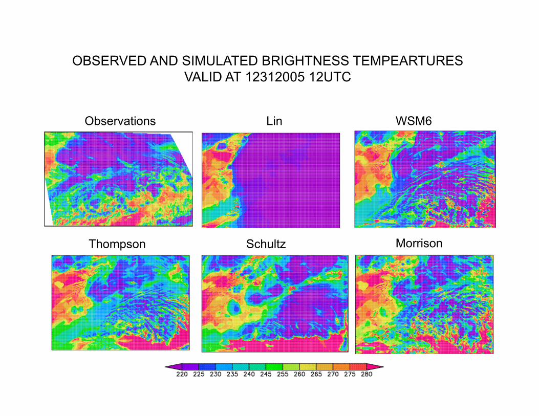
Observations Lin WSM6
Thompson Schultz Morrison
OBSERVED AND SIMULATED BRIGHTNESS TEMPEARTURES VALID AT 12312005 12UTC
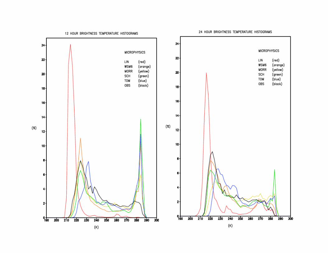
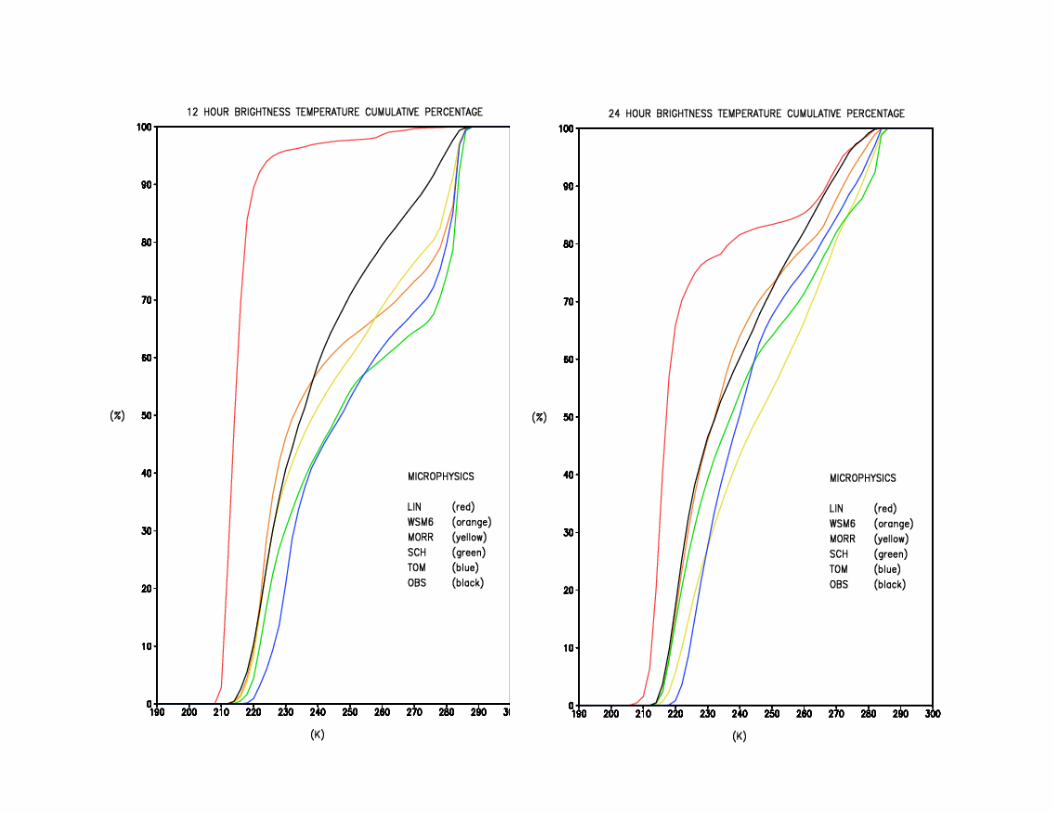
Probability of occurrence histograms
SUMMARY
o All of the evaluated microphysical schemes, except Lin, performed generally well in simulating high clouds, while the lower cloud coverage was somewhat underestimated, especially at earlier times.
o The Lin microphysics showed tendency to produce too many high clouds.
o Results suggest that synthetic satellite imagery can be very useful as a tool to evaluate the performance of a model.
o Further more, synthetic satellite imagery can be potentially useful in better understanding and improvement of the existing microphysical schemes