Embed Size (px)
Citation preview
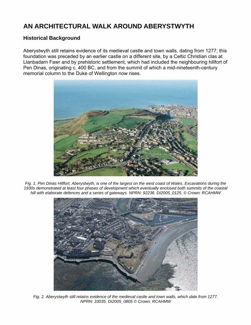
AN ARCHITECTURAL WALK AROUND ABERYSTWYTH Historical Background Aberystwyth still retains evidence of its medieval castle and town walls, dating from 1277; this foundation was preceded by an earlier castle on a different site, by a Celtic Christian clas at Llanbadarn Fawr and by prehistoric settlement, which had included the neighbouring hillfort of Pen Dinas, originating c. 400 BC, and from the summit of which a mid-nineteenth-century memorial column to the Duke of Wellington now rises.
Fig. 1. Pen Dinas vations during the
1930s demon its of the coastal hill with elabo n: RCAHMW
Fig. 2. Aberystwyth still retains evidence of the medieval castle and town walls, which date from 1277. NPRN: 33035. DI2005_0805 © Crown: RCAHMW
Hillfort, Aberystwyth, is one of the largest on the west coast of Wales. Excastrated at least four phases of development which eventually enclosed both summ
rate defences and a series of gateways. NPRN: 92236. DI2005_0125. © Crow
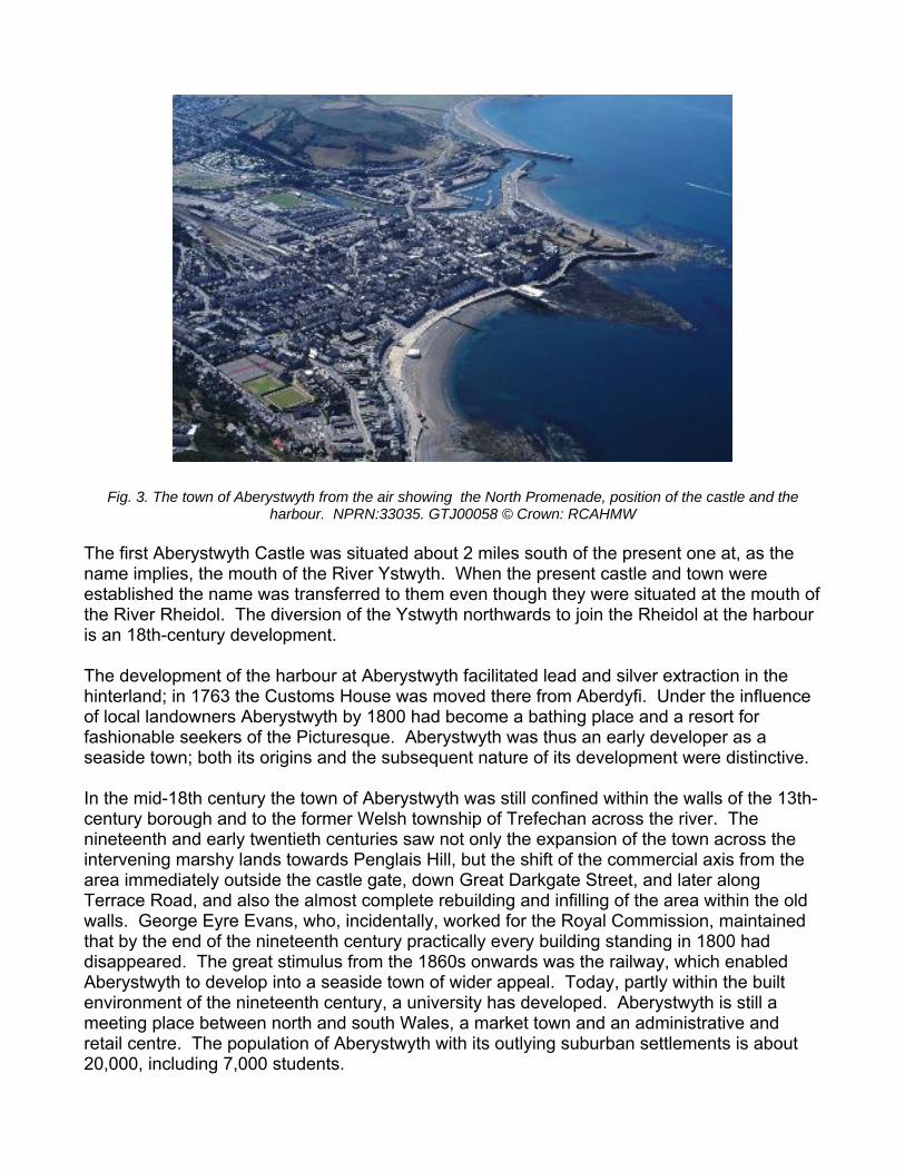
Fig. 3. The town of Aberystwyth from the air showing the North Promenade, position of the castle and the harbour. NPRN:33035. GTJ00058 © Crown: RCAHMW
The first Aberystwyth Castle was situated about 2 miles south of the present one at, as the name implies, the mouth of the River Ystwyth. When the present castle and town were established the name was transferred to them even though they were situated at the mouth of the River Rheidol. The diversion of the Ystwyth northwards to join the Rheidol at the harbour is an 18th-century development. The development of the harbour at Aberystwyth facilitated lead and silver extraction in the hinterland; in 1763 the Customs House was moved there from Aberdyfi. Under the influence of local landowners Aberystwyth by 1800 had become a bathing place and a resort for fashionable seekers of the Picturesque. Aberystwyth was thus an early developer as a seaside town; both its origins and the subsequent nature of its development were distinctive. In the mid-18th century the town of Aberystwyth was still confined within the walls of the 13th-century borough and to the former Welsh township of Trefechan across the river. The nineteenth and early twentieth centuries saw not only the expansion of the town across the intervening marshy lands towards Penglais Hill, but the shift of the commercial axis from the area immediately outside the castle gate, down Great Darkgate Street, and later along Terrace Road, and also the almost complete rebuilding and infilling of the area within the old walls. George Eyre Evans, who, incidentally, worked for the Royal Commission, maintained that by the end of the nineteenth century practically every building standing in 1800 had disappeared. The great stimulus from the 1860s onwards was the railway, which enabled Aberystwyth to develop into a seaside town of wider appeal. Today, partly within the built environment of the nineteenth century, a university has developed. Aberystwyth is still a meeting place between north and south Wales, a market town and an administrative and retail centre. The population of Aberystwyth with its outlying suburban settlements is about 20,000, including 7,000 students.
The Walking Tour
d home of
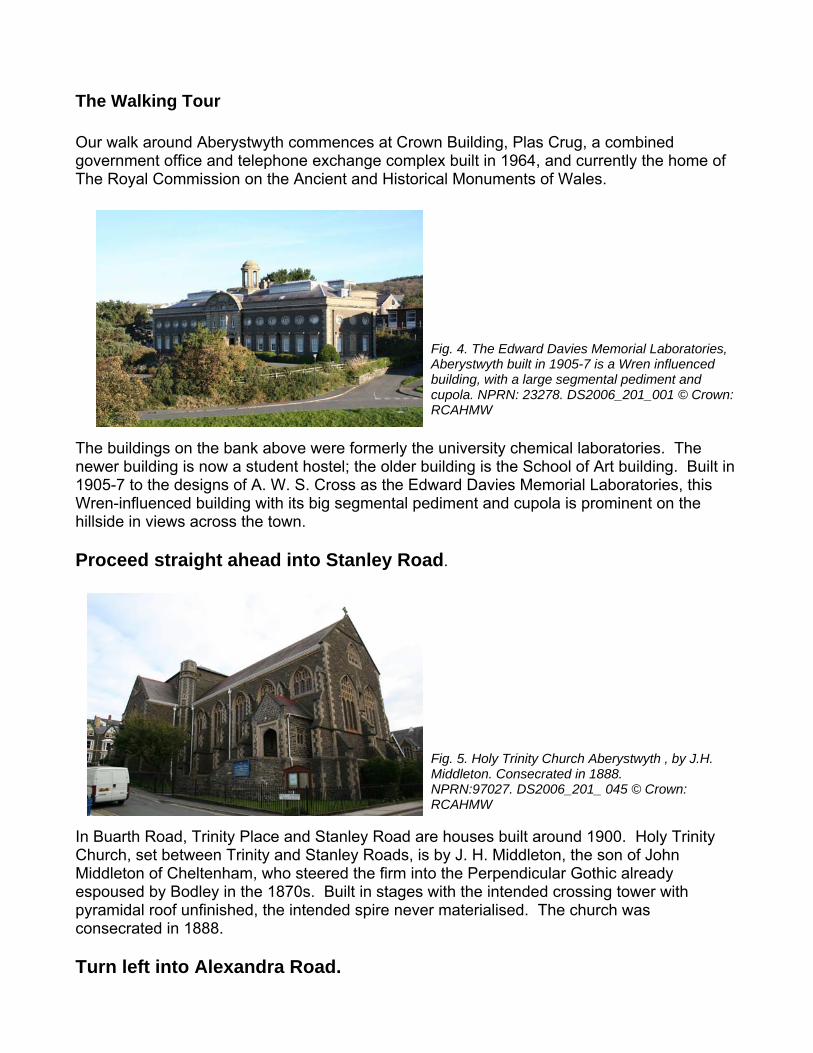
Fig. 4. The EdwAberystwyth buibuilding, with a cupola. NPRN: RCAHMW
ard Davies Memorial Laboratories, lt in 1905-7 is a Wren influenced large segmental pediment and 23278. DS2006_201_001 © Crown:
The buildings on the bank above were formerly the university chemical laboratories. The newer building is now a student hostel; the older building is the School of Art building. Built in 1905-7 to the designs of A. W. S. Cross as the Edward Davies Memorial Laboratories, this Wren-influenced building with its big segmental pediment and cupola is prominent on the hillside in views across the town.
.
Fig. 5. Holy Trinity Church Aberystwyth , by J.H. Middleton. Consecrated in 1888. NPRN:97027. DS2006_201_ 045 © Crown: RCAHMW
In Buarth Road, Trinity Place and Stanley Road are houses built around 1900. Holy Trinity Church, set between Trinity and Stanley Roads, is by J. H. Middleton, the son of John Middleton of Cheltenham, who steered the firm into the Perpendicular Gothic already espoused by Bodley in the 1870s. Built in stages with the intended crossing tower with pyramidal roof unfinished, the intended spire never materialised. The church was consecrated in 1888. Turn left into Alexandra Road.
Our walk around Aberystwyth commences at Crown Building, Plas Crug, a combinegovernment office and telephone exchange complex built in 1964, and currently the The Royal Commission on the Ancient and Historical Monuments of Wales.
Proceed straight ahead into Stanley Road
The bus station and retail stores are built on the site of the old railway goods yard. Opposite the bus station, on the site of the Job Centre, was Green’s Foundry, which produced a vast range of items from garden gates to steam engines, but was best known for its ore-dressing equipment; its machinery was exported all over the world. A fire in 1908 finished the works; after several other uses, it was demolished in 1994 and replaced by the present office and housing complex.
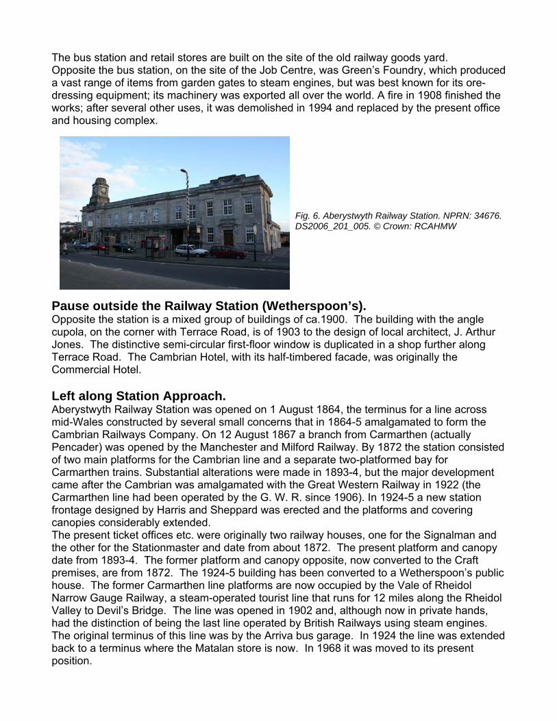
Fig. 6. Aberystwyth Railway Station. NPRN: 34676. DS2006_201_005. © Crown: RCAHMW
Pause outside the Railway Station (Wetherspoon’s). Opposite the station is a mixed group of buildings of ca.1900. The building with the angle cupola, on the corner with Terrace Road, is of 1903 to the design of local architect, J. Arthur Jones. The distinctive semi-circular first-floor window is duplicated in a shop further along Terrace Road. The Cambrian Hotel, with its half-timbered facade, was originally the Commercial Hotel. Left along Station Approach. Aberystwyth Railway Station was opened on 1 August 1864, the terminus for a line across mid-Wales constructed by several small concerns that in 1864-5 amalgamated to form the Cambrian Railways Company. On 12 August 1867 a branch from Carmarthen (actually Pencader) was opened by the Manchester and Milford Railway. By 1872 the station consisted of two main platforms for the Cambrian line and a separate two-platformed bay for Carmarthen trains. Substantial alterations were made in 1893-4, but the major development came after the Cambrian was amalgamated with the Great Western Railway in 1922 (the Carmarthen line had been operated by the G. W. R. since 1906). In 1924-5 a new station frontage designed by Harris and Sheppard was erected and the platforms and covering canopies considerably extended. The present ticket offices etc. were originally two railway houses, one for the Signalman and the other for the Stationmaster and date from about 1872. The present platform and canopy date from 1893-4. The former platform and canopy opposite, now converted to the Craft premises, are from 1872. The 1924-5 building has been converted to a Wetherspoon’s public house. The former Carmarthen line platforms are now occupied by the Vale of Rheidol Narrow Gauge Railway, a steam-operated tourist line that runs for 12 miles along the Rheidol Valley to Devil’s Bridge. The line was opened in 1902 and, although now in private hands, had the distinction of being the last line operated by British Railways using steam engines. The original terminus of this line was by the Arriva bus garage. In 1924 the line was extended back to a terminus where the Matalan store is now. In 1968 it was moved to its present position.
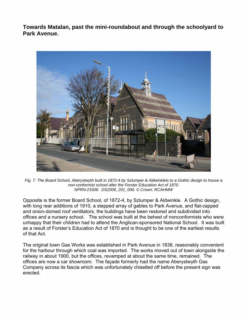
Towards Matalan, past the mini-roundabout and through the schoolyard to Park Avenue. Fig. 7. The Board School, Aberystwyth built in 1872-4 by Szlumper & Aldwinkleis to a Gothic design to house a
non-conformist school after the Forster Education Act of 1870. NPRN:23306. DS2006_201_006. © Crown: RCAHMW
Opposite is the former Board School, of 1872-4, by Szlumper & Aldwinkle. A Gothic design, with long rear additions of 1910, a stepped array of gables to Park Avenue, and flat-capped and onion-domed roof ventilators, the buildings have been restored and subdivided into offices and a nursery school. The school was built at the behest of nonconformists who were unhappy that their children had to attend the Anglican-sponsored National School. It was built as a result of Forster’s Education Act of 1870 and is thought to be one of the earliest results of that Act. The original town Gas Works was established in Park Avenue in 1838, reasonably convenient for the harbour through which coal was imported. The works moved out of town alongside the railway in about 1900, but the offices, revamped at about the same time, remained. The offices are now a car showroom. The façade formerly had the name Aberystwyth Gas Company across its fascia which was unfortunately chiselled off before the present sign was erected.
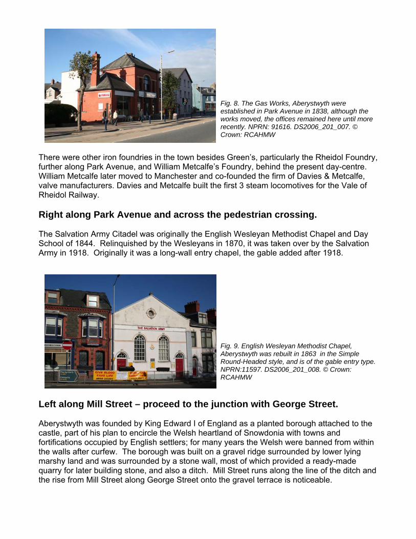
Fig. 8. The Gas Works, Aberystwyth were established in Park Avenue in 1838, although the works moved, the offices remained here until more recently. NPRN: 91616. DS2006_201_007. © Crown: RCAHMW
des Green’s, particularly the Rheidol Foundry, Foundry, behind the present day-centre.
and co-founded the firm of Davies & Metcalfe, the first 3 steam locomotives for the Vale of
across the pedestrian crossing.
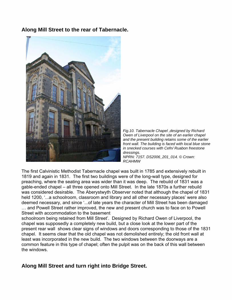
e English Wesleyan Methodist Chapel and Day
in 1870, it was taken over by the Salvation wall entry chapel, the gable added after 1918.
Fig. 9. English Wesleyan Methodist Chapel, Aberystwyth was rebuilt in 1863 in the Simple Round-Headed style, and is of the gable entry type. NPRN:11597. DS2006_201_008. © Crown: RCAHMW
Left along Mill Street – proceed to the junction with George Street. Aberystwyth was founded by King Edward I of England as a planted borough attached to the castle, part of his plan to encircle the Welsh heartland of Snowdonia with towns and fortifications occupied by English settlers; for many years the Welsh were banned from within the walls after curfew. The borough was built on a gravel ridge surrounded by lower lying marshy land and was surrounded by a stone wall, most of which provided a ready-made quarry for later building stone, and also a ditch. Mill Street runs along the line of the ditch and the rise from Mill Street along George Street onto the gravel terrace is noticeable.
There were other iron foundries in the town besifurther along Park Avenue, and William Metcalfe’s William Metcalfe later moved to Manchester valve manufacturers. Davies and Metcalfe built Rheidol Railway.
Right along Park Avenue and
The Salvation Army Citadel was originally thSchool of 1844. Relinquished by the Wesleyans Army in 1918. Originally it was a long-
Along Mill Street to the rear of Tabernacle.
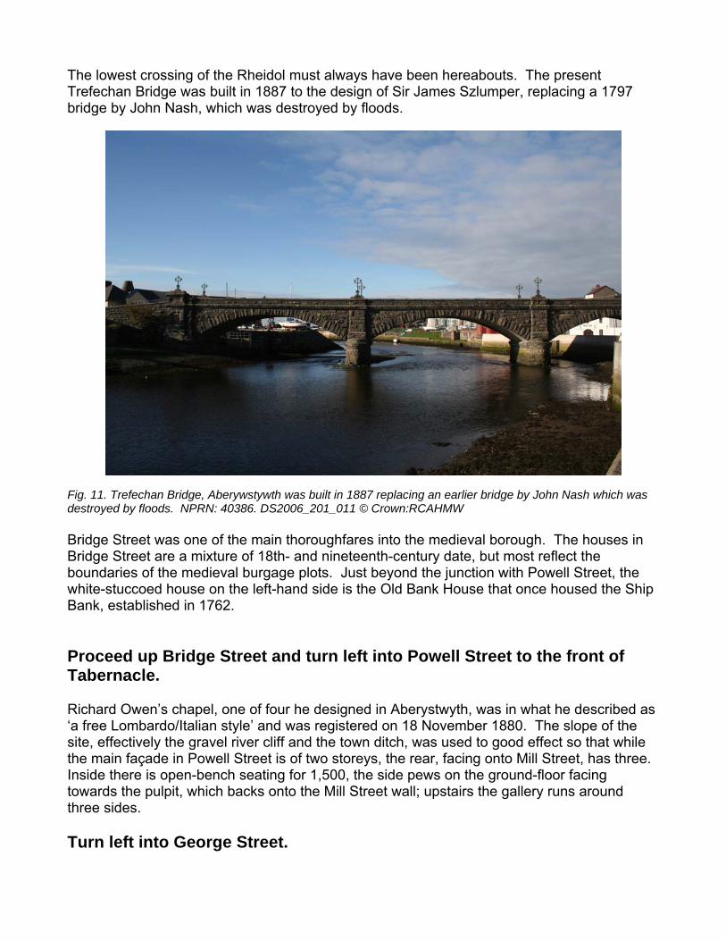
Fig.10. Tabernacle Chapel ,designed by Richard Owen of Liverpool on the site of an earlier chapel and the present building retains some of the earlier front wall. The building is faced with local blue stone in snecked courses with Cefn/ Ruabon freestone dressings. NPRN: 7157. DS2006_201_014. © Crown: RCAHMW
The first Calvinistic Methodist Tabernacle chapel was built in 1785 and extensively rebuilt in 1819 and again in 1831. The first two buildings were of the long-wall type, designed for preaching, where the seating area was wider than it was deep. The rebuild of 1831 was a gable-ended chapel – all three opened onto Mill Street. In the late 1870s a further rebuild was considered desirable. The Aberystwyth Observer noted that although the chapel of 1831 held 1200, ‘...a schoolroom, classroom and library and all other necessary places’ were also deemed necessary, and since ‘...of late years the character of Mill Street has been damaged … and Powell Street rather improved, the new and present church was to face on to Powell Street with accommodation to the basement schoolroom being retained from Mill Street’. Designed by Richard Owen of Liverpool, the chapel was supposedly a completely new build, but a close look at the lower part of the present rear wall shows clear signs of windows and doors corresponding to those of the 1831 chapel. It seems clear that the old chapel was not demolished entirely; the old front wall at least was incorporated in the new build. The two windows between the doorways are a common feature in this type of chapel; often the pulpit was on the back of this wall between the windows. Along Mill Street and turn right into Bridge Street.
The lowest crossing of the Rheidol must always have been hereabouts. The present Trefechan Bridge was built in 1887 to the design of Sir James Szlumper, replacing a 1797 bridge by John Nash, which was destroyed by floods. Fig. 11. Trefechan Bridge, Aberywstywth was built in 1887 replacing an earlier bridge by John Nash which was destroyed by floods. NPRN: 40386. DS2006_201_011 © Crown:RCAHMW Bridge Street was one of the main thoroughfares into the medieval borough. The houses in Bridge Street are a mixture of 18th- and nineteenth-century date, but most reflect the boundaries of the medieval burgage plots. Just beyond the junction with Powell Street, the white-stuccoed house on the left-hand side is the Old Bank House that once housed the Ship Bank, established in 1762. Proceed up Bridge Street and turn left into Powell Street to the front of Tabernacle. Richard Owen’s chapel, one of four he designed in Aberystwyth, was in what he described as ‘a free Lombardo/Italian style’ and was registered on 18 November 1880. The slope of the site, effectively the gravel river cliff and the town ditch, was used to good effect so that while the main façade in Powell Street is of two storeys, the rear, facing onto Mill Street, has three. Inside there is open-bench seating for 1,500, the side pews on the ground-floor facing towards the pulpit, which backs onto the Mill Street wall; upstairs the gallery runs around three sides. Turn left into George Street.
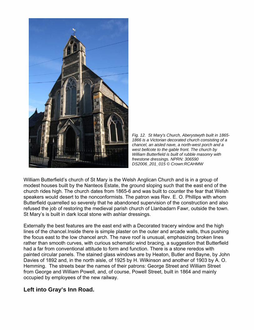
Fig. 12. St Mary's Church, Aberystwyth built in 1865-1866 is a Victorian decorated church consisting of a chancel, an aisled nave, a north-west porch and a west bellcote to the gable front. The church by William Butterfield is built of rubble masonry with freestone dressings. NPRN: 306590 DS2006_201_015 © Crown:RCAHMW
William Butterfield’s church of St Mary is the Welsh Anglican Church and is in a group of modest houses built by the Nanteos Estate, the ground sloping such that the east end of the church rides high. The church dates from 1865-6 and was built to counter the fear that Welsh speakers would desert to the nonconformists. The patron was Rev. E. O. Phillips with whom Butterfield quarrelled so severely that he abandoned supervision of the construction and also refused the job of restoring the medieval parish church of Llanbadarn Fawr, outside the town. St Mary’s is built in dark local stone with ashlar dressings. Externally the best features are the east end with a Decorated tracery window and the high lines of the chancel.Inside there is simple plaster on the outer and arcade walls, thus pushing the focus east to the low chancel arch. The nave roof is unusual, emphasizing broken lines rather than smooth curves, with curious schematic wind bracing, a suggestion that Butterfield had a far from conventional attitude to form and function. There is a stone reredos with painted circular panels. The stained glass windows are by Heaton, Butler and Bayne, by John Davies of 1892 and, in the north aisle, of 1925 by H. Wilkinson and another of 1903 by A. O. Hemming. The streets bear the names of their patrons: George Street and William Street from George and William Powell, and, of course, Powell Street, built in 1864 and mainly occupied by employees of the new railway. Left into Gray’s Inn Road.
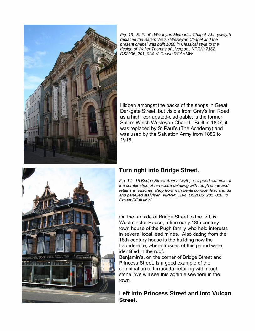
Fig. 13. St Paul's Wesleyan Methodist Chapel, Aberystwyth replaced the Salem Welsh Wesleyan Chapel and the present chapel was built 1880 in Classical style to the design of Walter Thomas of Liverpool. NPRN: 7162. DS2006_201_024. © Crown:RCAHMW Hidden amongst the backs of the shops in Great Darkgate Street, but visible from Gray’s Inn Road as a high, corrugated-clad gable, is the former Salem Welsh Wesleyan Chapel. Built in 1807, it was replaced by St Paul’s (The Academy) and was used by the Salvation Army from 1882 to 1918. Turn right into Bridge Street. Fig. 14. 15 Bridge Street Aberystwyth, is a good example of the combination of terracotta detailing with rough stone and retains a Victorian shop front with dentil cornice, fascia ends and panelled stallriser. NPRN: 5164. DS2006_201_018. © Crown:RCAHMW On the far side of Bridge Street to the left, is Westminster House, a fine early 18th century town house of the Pugh family who held interests in several local lead mines. Also dating from the 18th-century house is the building now the Launderette, where trusses of this period were identified in the roof. Benjamin’s, on the corner of Bridge Street and Princess Street, is a good example of the combination of terracotta detailing with rough stone. We will see this again elsewhere in the town. Left into Princess Street and into Vulcan Street.
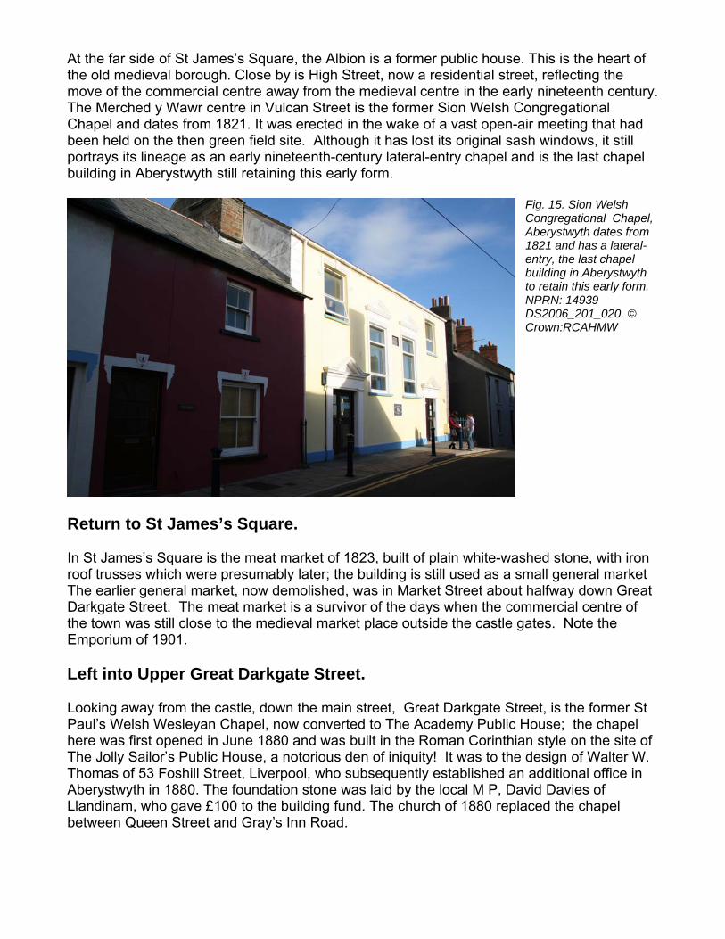
At the far side of St James’s Square, the Albion is a former public house. This is the heart of the old medieval borough. Close by is High Street, now a residential street, reflecting the move of the commercial centre away from the medieval centre in the early nineteenth century. The Merched y Wawr centre in Vulcan Street is the former Sion Welsh Congregational Chapel and dates from 1821. It was erected in the wake of a vast open-air meeting that had been held on the then green field site. Although it has lost its original sash windows, it still
chapel and is the last chapel
Fig. 15. Sion Welsh Congregational Chapel, Aberystwyth dates from 1821 and has a lateral-entry, the last chapel building in Aberystwyth to retain this early form. NPRN: 14939 DS2006_201_020. © Crown:RCAHMW
Return to St James’s Square. In St James’s Square is the meat market of 1823, built of plain white-washed stone, with iron roof trusses which were presumably later; the building is still used as a small general market The earlier general market, now demolished, was in Market Street about halfway down Great Darkgate Street. The meat market is a survivor of the days when the commercial centre of the town was still close to the medieval market place outside the castle gates. Note the Emporium of 1901. Left into Upper Great Darkgate Street. Looking away from the castle, down the main street, Great Darkgate Street, is the former St Paul’s Welsh Wesleyan Chapel, now converted to The Academy Public House; the chapel here was first opened in June 1880 and was built in the Roman Corinthian style on the site of The Jolly Sailor’s Public House, a notorious den of iniquity! It was to the design of Walter W. Thomas of 53 Foshill Street, Liverpool, who subsequently established an additional office in Aberystwyth in 1880. The foundation stone was laid by the local M P, David Davies of Llandinam, who gave £100 to the building fund. The church of 1880 replaced the chapel between Queen Street and Gray’s Inn Road.
portrays its lineage as an early nineteenth-century lateral-entry building in Aberystwyth still retaining this early form.
Along Upper Great Darkgate Street towards the castle, then right into Laura Place.
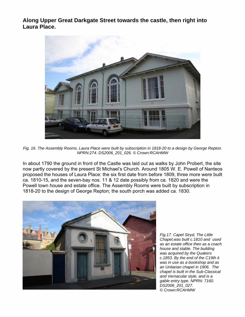
Fig. 16. The Assembly Rooms, Laura Place were built by subscription in 1818-20 to a design by George Repton.
NPRN:274. DS2006_201_026. © Crown:RCAHMW In about 1790 the ground in front of the Castle was laid out as walks by John Probert, the site now partly covered by the present St Michael’s Church. Around 1805 W. E. Powell of Nanteos
date from before 1809, three more were built e possibly from ca. 1820 and were the ly Rooms were built by subscription in
ch was added ca. 1830.
Fig.17. Capel Stryd, The Little Chapel,was built c.1810 and used as an estate office then as a coach house and stable. The building was acquired by the Quakers c.1853. By the end of the C19th it was in use as a bookshop and as an Unitarian chapel in 1906. The chapel is built in the Sub-Classical and Vernacular style, and is a gable entry type. NPRN: 7160. DS2006_201_027. © Crown:RCAHMW
proposed the houses of Laura Place: the six first ca. 1810-15, and the seven-bay nos. 11 & 12 datPowell town house and estate office. The Assemb1818-20 to the design of George Repton; the south por
Right into New Street. On the corner of New Street and Castle Street is the Little Chapel, which may be a candidate for smallest town chapel in Wales. Originally built in the early nineteenth century as an
a
coach hous
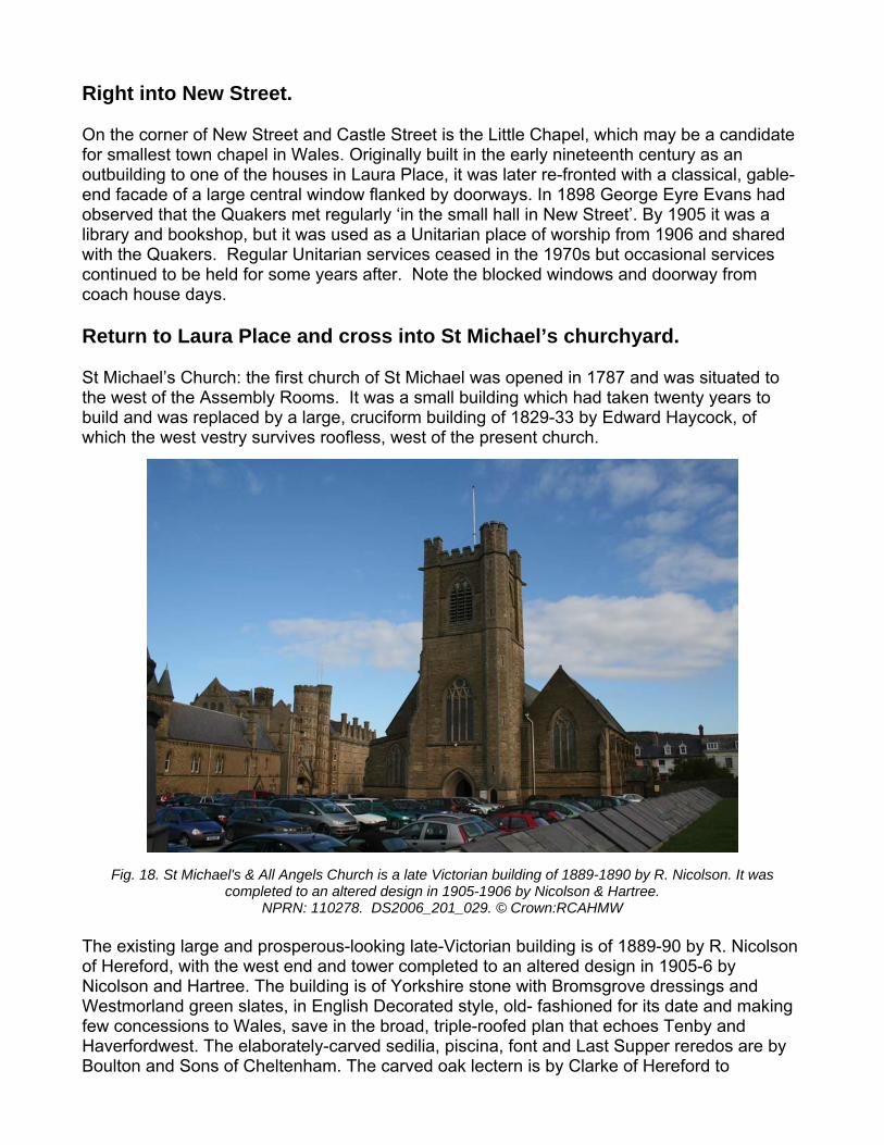
Fig. 18. St Michael's & All Angels Church is a late Victorian building of 1889-1890 by R. Nicolson. It was completed to an altered design in 1905-1906 by Nicolson & Hartree.
NPRN: 110278. DS2006_201_029. © Crown:RCAHMW The existing large and prosperous-looking late-Victorian building is of 1889-90 by R. Nicolson of Hereford, with the west end and tower completed to an altered design in 1905-6 by Nicolson and Hartree. The building is of Yorkshire stone with Bromsgrove dressings and Westmorland green slates, in English Decorated style, old- fashioned for its date and making few concessions to Wales, save in the broad, triple-roofed plan that echoes Tenby and Haverfordwest. The elaborately-carved sedilia, piscina, font and Last Supper reredos are by Boulton and Sons of Cheltenham. The carved oak lectern is by Clarke of Hereford to
outbuilding to one of the houses in Laura Place, it was later re-fronted with a classical, gable-end facade of a large central window flanked by doorways. In 1898 George Eyre Evans had observed that the Quakers met regularly ‘in the small hall in New Street’. By 1905 it waslibrary and bookshop, but it was used as a Unitarian place of worship from 1906 and shared with the Quakers. Regular Unitarian services ceased in the 1970s but occasional services continued to be held for some years after. Note the blocked windows and doorway from
e days.
Return to Laura Place and cross into St Michael’s churchyard.
St Michael’s Church: the first church of St Michael was opened in 1787 and was situated to the west of the Assembly Rooms. It was a small building which had taken twenty years to build and was replaced by a large, cruciform building of 1829-33 by Edward Haycock, of which the west vestry survives roofless, west of the present church.
Nicholson’s design. Of the stained glass, the east window and north aisle east window are of 1889, both by A. O. Hemming, and good in the strong colours of Clayton and Bell. The four later south aisle windows are of 1903, also by Hemming. The north aisle window is of 1914 by Powell. W. D. Caröe’s chancel screen and rood are of 1921-7. A few of the early-nineteenth-century monuments have been removed to the west porch; the west memorial in the north aisle is by Chantrey. There seems to have been an inability in Aberystwyth to complete spires. The tower here, completed in 1906, was intended to have a spire. You may recall that Holy Trinity, on the Buarth, was planned to have a spire, and St Winefrede’s Roman Catholic Church, which we will see later, was also to have had one. Walk through the car park to the Old Vestry.
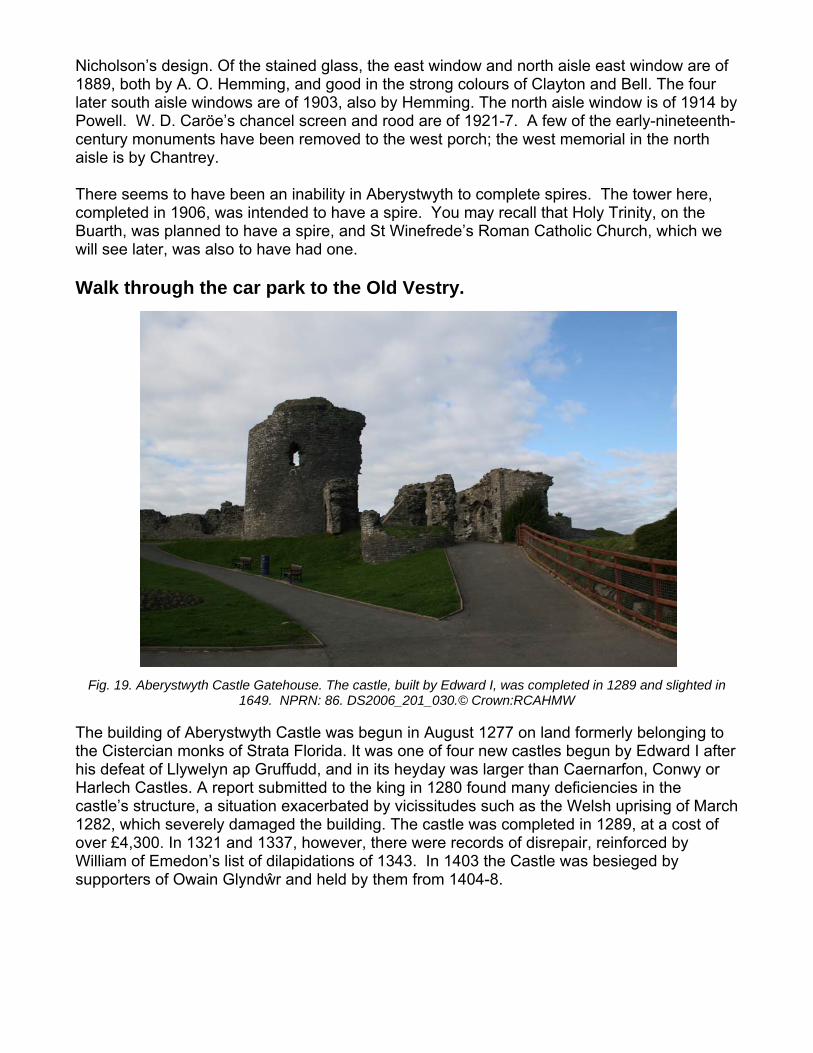
Fig. 19. Aberyst ghted in
The building of Aberystwyth Castle was begun in August 1277 on land formerly belonging to the Cistercian monks of Strata Florida. It was one of four new castles begun by Edward I after his defeat of Llywelyn ap Gruffudd, and in its heyday was larger than Caernarfon, Conwy or Harlech Castles. A report submitted to the king in 1280 found many deficiencies in the castle’s structure, a situation exacerbated by vicissitudes such as the Welsh uprising of March 1282, which severely damaged the building. The castle was completed in 1289, at a cost of over £4,300. In 1321 and 1337, however, there were records of disrepair, reinforced by William of Emedon’s list of dilapidations of 1343. In 1403 the Castle was besieged by supporters of Owain Glyndŵr and held by them from 1404-8.
wyth Castle Gatehouse. The castle, built by Edward I, was completed in 1289 and sli1649. NPRN: 86. DS2006_201_030.© Crown:RCAHMW
The Castle and War Memorial
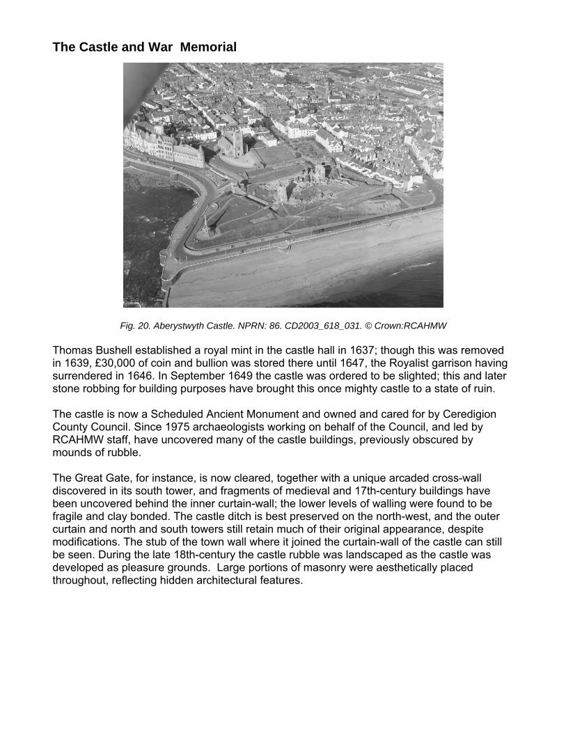
Thomas Bushell established a royal mint in the castle hall in 1637; though this was removed in 1639, £30,000 of coin and bullion was stored there until 1647, the Royalist garrison having surrendered in 1646. In September 1649 the castle was ordered to be slighted; this and later stone robbing for building purposes have brought this once mighty castle to a state of ruin. The castle is now a Scheduled Ancient Monument and owned and cared for by Ceredigion County Council. Since 1975 archaeologists working on behalf of the Council, and led by RCAHMW staff, have uncovered many of the castle buildings, previously obscured by mounds of rubble. The Great Gate, for instance, is now cleared, together with a unique arcaded cross-wall discovered in its south tower, and fragments of medieval and 17th-century buildings have been uncovered behind the inner curtain-wall; the lower levels of walling were found to be fragile and clay bonded. The castle ditch is best preserved on the north-west, and the outer curtain and north and south towers still retain much of their original appearance, despite modifications. The stub of the town wall where it joined the curtain-wall of the castle can still be seen. During the late 18th-century the castle rubble was landscaped as the castle was developed as pleasure grounds. Large portions of masonry were aesthetically placed throughout, reflecting hidden architectural features.
Fig. 20. Aberystwyth Castle. NPRN: 86. CD2003_618_031. © Crown:RCAHMW
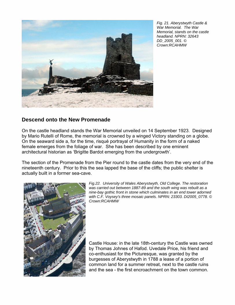
Fig. 21. Aberystwyth Castle & War Memorial. The War Memorial, stands on the castle headland. NPRN: 32643 DD_2005_001. © Crown:RCAHMW
On the castle headland stands the War Memorial unveiled on 14 September 1923. Designed by Mario Rutelli of Rome, the memorial is crowned by a winged Victory standing on a globe. On the seaward side a, for the time, risqué portrayal of Humanity in the form of a naked female emerges from the foliage of war. She has been described by one eminent architectural historian as ‘Brigitte Bardot emerging from the undergrowth’. The section of the Promenade from the Pier round to the castle dates from the very end of the nineteenth century. Prior to this the sea lapped the base of the cliffs; the public shelter is actually built in a former sea-cave.
Fig.22. University of Wales Aberystwyth, Old College. The restoration was carried out between 1887-89 and the south wing was rebuilt as a nine-bay gothic front in stone which culminates in an end tower adorned with C.F. Voysey's three mosaic panels. NPRN: 23303. DI2005_0778. © Crown:RCAHMW Castle House: in the late 18th-century the Castle was owned by Thomas Johnes of Hafod. Uvedale Price, his friend and co-enthusiast for the Picturesque, was granted by the burgesses of Aberystwyth in 1788 a lease of a portion of common land for a summer retreat, next to the castle ruins and the sea - the first encroachment on the town common.
Descend onto the New Promenade
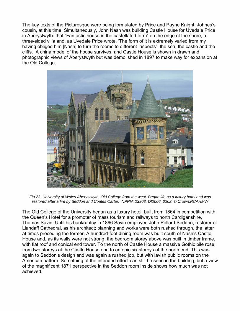
The key texts of the Picturesque were being formulated by Price and Payne Knight, Johnes’s cousin, at this time. Simultaneously, John Nash was building Castle House for Uvedale Price in Aberystwyth: that “Fantastic house in the castellated form” on the edge of the shore, a three-sided villa and, as Uvedale Price wrote, ‘The form of it is extremely varied from my having obliged him [Nash] to turn the rooms to different aspects’- the sea, the castle and the cliffs. A china model of the house survives, and Castle House is shown in drawn and photographic views of Aberystwyth but was demolished in 1897 to make way for expansion at the Old College.
Fig.23. Uni l and was restored W
the Queen’s Hotel for a promoter of mass tourism and railways to north Cardiganshire, Thomas Savin. Until his bankruptcy in 1866 Savin employed John Pollard Seddon, restorer of Llandaff Cathedral, as his architect; planning and works were both rushed through, the latter at times preceding the former. A hundred-foot dining room was built south of Nash’s Castle House and, as its walls were not strong, the bedroom storey above was built in timber frame, with flat roof and conical end tower. To the north of Castle House a massive Gothic pile rose, from two storeys at the Castle House end to an epic six storeys at the north end. This was again to Seddon’s design and was again a rushed job, but with lavish public rooms on the American pattern. Something of the intended effect can still be seen in the building, but a view of the magnificent 1871 perspective in the Seddon room inside shows how much was not achieved.
versity of Wales Aberystwyth, Old College from the west. Began life as a luxury hote
after a fire by Seddon and Coates Carter. NPRN: 23303. DI2006_0202. © Crown:RCAHM
The Old College of the University began as a luxury hotel, built from 1864 in competition with
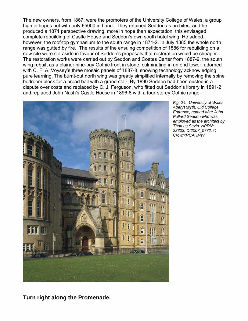
The new owners, from 1867, were the promoters of the University College of Wales, a group high in hopes but with only £5000 in hand. They retained Seddon as architect and he produced a 1871 perspective drawing, more in hope than expectation; this envisaged complete rebuilding of Castle House and Seddon’s own south hotel wing. He added, however, the roof-top gymnasium to the south range in 1871-2. In July 1885 the whole north range was gutted by fire. The results of the ensuing competition of 1886 for rebuilding on a new site were set aside in favour of Seddon’s proposals that restoration would be cheaper. The restoration works were carried out by Seddon and Coates Carter from 1887-9, the south wing rebuilt as a plainer nine-bay Gothic front in stone, culminating in an end tower, adorned with C. F. A. Voysey’s three mosaic panels of 1887-8, showing technology acknowledging pure learning. The burnt-out north wing was greatly simplified internally by removing the spine bedroom block for a broad hall with a grand stair. By 1890 Seddon had been ousted in a dispute over costs and replaced by C. J. Ferguson, who fitted out Seddon’s library in 1891-2 and replaced John Nash’s Castle House in 1896-8 with a four-storey Gothic range.
Fig. 24. University of Wales Aberystwyth, Old College Entrance, named after John Pollard Seddon who was employed as the architect by Thomas Savin. NPRN: 23303. DI2007_0772. © Crown:RCAHMW
Turn right along the Promenade.
In the small seaward court outside the college building is a rare, probably unique, statue of the later Edward VIII as Prince of Wales, executed in 1922 by Rutelli; Edward was Chancellor of the University.
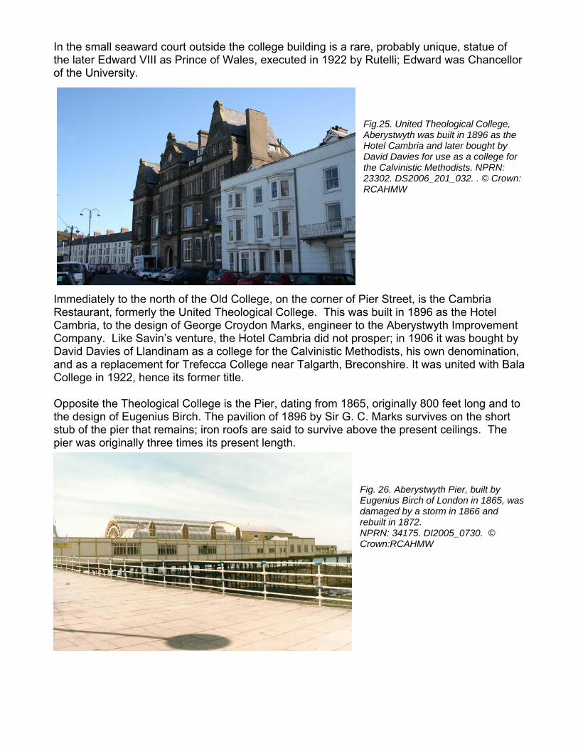
Fig.25. United Theological College, Aberystwyth was built in 1896 as the Hotel Cambria and later bought by David Davies for use as a college for the Calvinistic Methodists. NPRN: 23302. DS2006_201_032. . © Crown: RCAHMW
Immediately to the north of the Old College, on the corner of Pier Street, is the Cambria Restaurant, formerly the United Theological College. This was built in 1896 as the Hotel Cambria, to the design of George Croydon Marks, engineer to the Aberystwyth Improvement Company. Like Savin’s venture, the Hotel Cambria did not prosper; in 1906 it was bought by David Davies of Llandinam as a college for the Calvinistic Methodists, his own denomination, and as a replacement for Trefecca College near Talgarth, Breconshire. It was united with Bala College in 1922, hence its former title.
ginally 800 feet long and to 1896 by Sir G. C. Marks survives on the short
above the present ceilings. The
Fig. 26. Aberystwyth Pier, built by Eugenius Birch of London in 1865, was damaged by a storm in 1866 and rebuilt in 1872. NPRN: 34175. DI2005_0730. © Crown:RCAHMW
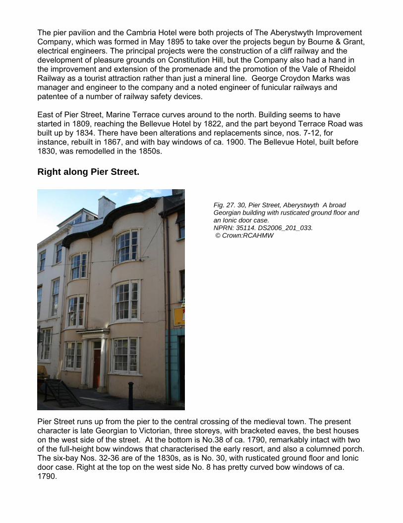
Opposite the Theological College is the Pier, dating from 1865, orithe design of Eugenius Birch. The pavilion of stub of the pier that remains; iron roofs are said to survive pier was originally three times its present length.
The pier pavilion and the Cambria Hotel were both projects of The Aberystwyth Improvement Company, which was formed in May 1895 to take over the projects begun by Bourne & Grant, electrical engineers. The principal projects were the construction of a cliff railway and the development of pleasure grounds on Constitution Hill, but the Company also had a hand in the improvement and extension of the promenade and the promotion of the Vale of Rheidol Railway as a tourist attraction rather than just a mineral line. George Croydon Marks was manager and engineer to the company and a noted engineer of funicular railways and patentee of a number of railway safety devices. East of Pier Street, Marine Terrace curves around to the north. Building seems to have
he Bellevue Hotel by 1822, and the part beyond Terrace Road was s and replacements since, nos. 7-12, for
ca. 1900. The Bellevue Hotel, built before
Fig. 27. 30, Pier Street, Aberystwyth A broad Georgian building with rusticated ground floor and an Ionic door case. NPRN: 35114. DS2006_201_033. © Crown:RCAHMW
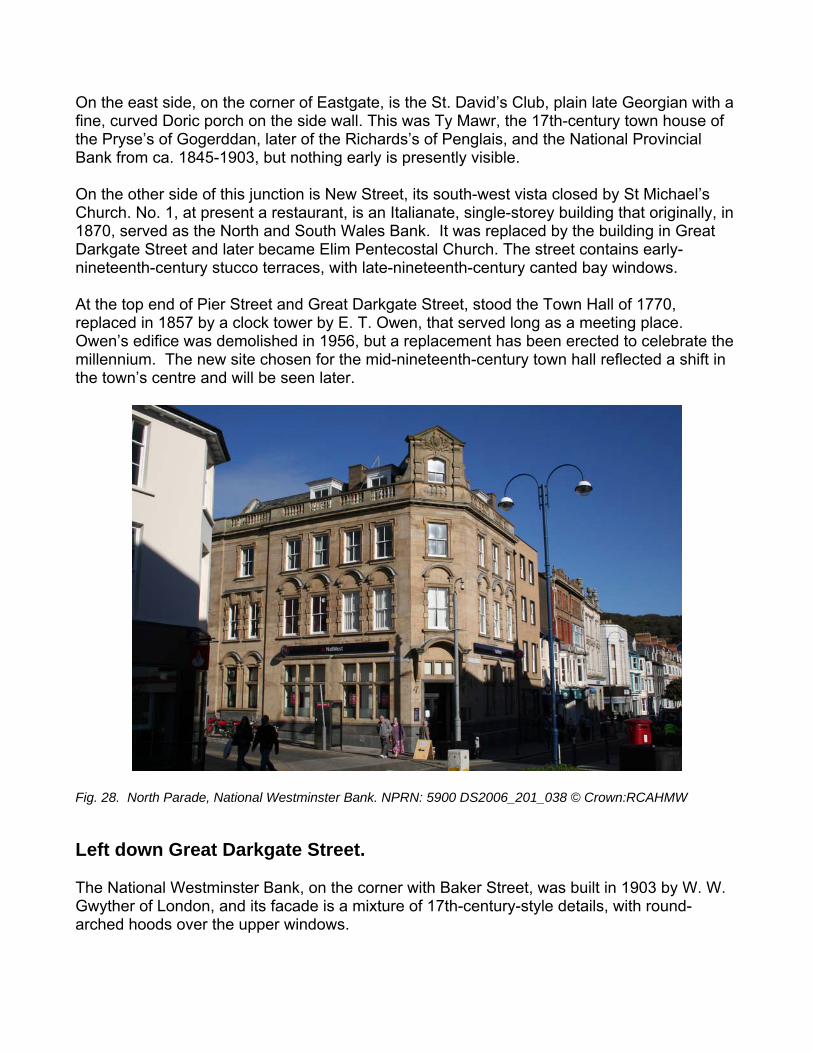
Pier Street runs up from the pier to the central crossing of the medieval town. The present character is late Georgian to Victorian, three storeys, with bracketed eaves, the best houses on the west side of the street. At the bottom is No.38 of ca. 1790, remarkably intact with two of the full-height bow windows that characterised the early resort, and also a columned porch. The six-bay Nos. 32-36 are of the 1830s, as is No. 30, with rusticated ground floor and Ionic door case. Right at the top on the west side No. 8 has pretty curved bow windows of ca. 1790.
started in 1809, reaching tbuilt up by 1834. There have been alterationinstance, rebuilt in 1867, and with bay windows of1830, was remodelled in the 1850s. Right along Pier Street.
On the east side, on the corner of Eastgate, is the St. David’s Club, plain late Georgian with a fine, curved Doric porch on the side wall. This was Ty Mawr, the 17th-century town house of the Pryse’s of Gogerddan, later of the Richards’s of Penglais, and the National Provincial Bank from ca. 1845-1903, but nothing early is presently visible. On the other side of this junction is New Street, its south-west vista closed by St Michael’s Church. No. 1, at present a restaurant, is an Italianate, single-storey building that originally, in 1870, served as the North and South Wales Bank. It was replaced by the building in Great Darkgate Street and later became Elim Pentecostal Church. The street contains early-nineteenth-century stucco terraces, with late-nineteenth-century canted bay windows. At the top end of Pier Street and Great Darkgate Street, stood the Town Hall of 1770, replaced in 1857 by a clock tower by E. T. Owen, that served long as a meeting place. Owen’s edifice was demolished in 1956, but a replacement has been erected to celebrate the millennium. The new site chosen for the mid-nineteenth-century town hall reflected a shift in the town’s centre and will be seen later.
Fig. 28. North Parade, National Westminster Bank. NPRN: 5900 DS2006_201_038 © Crown:RCAHMW
Left down Great Darkgate Street. The National Westminster Bank, on the corner with Baker Street, was built in 1903 by W. W. Gwyther of London, and its facade is a mixture of 17th-century-style details, with round-arched hoods over the upper windows.
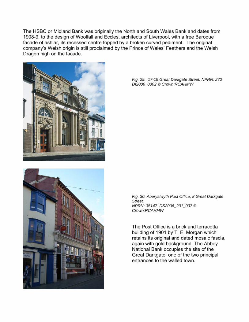
The HSBC or Midland Bank was originally the North and South Wales Bank and dates from 1908-9, to the design of Woolfall and Eccles, architects of Liverpool, with a free Baroque facade of ashlar, its recessed centre topped by a broken curved pediment. The original
the Prince of Wales’ Feathers and the Welsh
Fig. 29. 17-19 Great Darkgate Street. NPRN: 272 DI2006_0302 © Crown:RCAHMW Fig. 30. Aberystwyth Post Office, 8 Great Darkgate Street. NPRN: 35147. DS2006_201_037 © Crown:RCAHMW The Post Office is a brick and terracotta building of 1901 by T. E. Morgan which retains its original and dated mosaic fascia, again with gold background. The Abbey National Bank occupies the site of the Great Darkgate, one of the two principal entrances to the walled town.
company’s Welsh origin is still proclaimed by Dragon high on the facade.
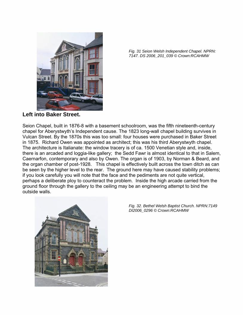
Fig. 31 Seion Welsh Independent Chapel. NPRN: 7147. DS 2006_201_039 © Crown:RCAHMW
h a basement schoolroom, was the fifth nineteenth-century
he 1823 long-wall chapel building survives in Vulcan Str four houses were purchased in Baker Street
t; this was his third Aberystwyth chapel. acery is of ca. 1500 Venetian style and, inside,
e gallery; the Sedd Fawr is almost identical to that in Salem, The organ is of 1903, by Norman & Beard, and
This chapel is effectively built across the town ditch as can he ground here may have caused stability problems; face and the pediments are not quite vertical,
perhaps a deliberate ploy to counteract the problem. Inside the high arcade carried from the ground floor through the gallery to the ceiling may be an engineering attempt to bind the outside walls.
Fig. 32. Bethel Welsh Baptist Church. NPRN:7149 DI2006_0296 © Crown:RCAHMW
Left into Baker Street.
Seion Chapel, built in 1876-8 witchapel for Aberystwyth’s Independent cause. T
eet. By the 1870s this was too small: in 1875. Richard Owen was appointed as architecThe architecture is Italianate: the window trthere is an arcaded and loggia-likCaernarfon, contemporary and also by Owen. the organ chamber of post-1928. be seen by the higher level to the rear. Tif you look carefully you will note that the
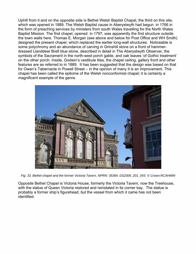
Uphill from it and on the opposite side is Bethel Welsh Baptist Chapel, the third on this site, which was opened in 1889. The Welsh Baptist cause in Aberystwyth had begun in 1766 in the form of preaching services by ministers from south Wales travelling for the North Wales Baptist Mission. The first chapel, opened in 1797, was apparently the first structure outside the town walls here. Thomas E. Morgan (see above and below for Post Office and WH Smith) designed the present chapel, which replaced the earlier long-wall structures. Noticeable is some polychromy and an abundance of carving in Grinshill stone on a front of hammer-dressed Llanddewi Brefi blue stone, described in detail in The Aberystwyth Observer, the symbols of the Sacrament in the north-west porch gable, and oak leaves ‘of Gothic treatment’ on the other porch. Inside, Godwin’s vestibule tiles, the chapel ceiling, gallery front and other features are as referred to in 1889. It has been suggested that the design was based on that for Owen’s Tabernacle in Powell Street – in the opinion of many it is an improvement. This chapel has been called the epitome of the Welsh nonconformist chapel; it is certainly a magnificent example of the genre.
Fig. 33. Bethel chapel and the former Victoria Tavern. NPRN: 35364. DS2006_201_043. © Crown:RCAHMW Opposite Bethel Chapel is Victoria House, formerly the Victoria Tavern, now the Treehouse, with the statue of Queen Victoria restored and reinstated in its corner bay. The statue is probably a former ship’s figurehead, but the vessel from which it came has not been identified.
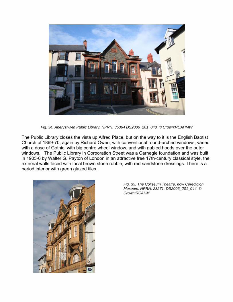
Fig. 34. Aberystwyth Public Library. NPRN: 35364 DS2006_201_043. © Crown:RCAHMW The Public Library closes the vista up Alfred Place, but on the way to it is the English Baptist Church of 1869-70, again by Richard Owen, with conventional round-arched windows, varied with a dose of Gothic, with big centre wheel window, and with gabled hoods over the outer windows. The Public Library in Corporation Street was a Carnegie foundation and was built in 1905-6 by Walter G. Payton of London in an attractive free 17th-century classical style, the external walls faced with local brown stone rubble, with red sandstone dressings. There is a period interior with green glazed tiles.
Fig. 35. The Coliseum Theatre, now Ceredigion Museum. NPRN: 23271. DS2006_201_044. © Crown:RCAHM
Right into Lower Eastgate. The Coliseum Theatre, now Ceredigion Museum, was built on the site of stables with a hall above, all of which burnt down in 1903. David Phillips built a new theatre, following the advice of the Chief of the London Fire Brigade, Captain Shaw (of Gilbert and Sullivan fame), by ensuring that it had plenty of good exits. The architect was Arthur Jones (see below for the schoolroom to St David’s United Reform Church in Bath Street and for Cambrian Chambers and the nearby corner building in Terrace Road). The building is faced with tiles, probably made in Ruabon, North Wales, as were many on new, early-twentieth-century buildings in Aberystwyth, except that the Coliseum tiles are yellow and the others are terracotta. The Coliseum was converted into a cinema in 1932 simply by installing a concrete projection box on the top gallery. It closed in 1977 and opened as a museum in 1983. Phillips was unable to purchase the entire site, hence the T-shape of his building, with facades on Terrace Road, Bath Street and Portland Street. It is unusual in having a statue of King Edward VII in each façade. There was a local manufacturer of terracotta. Dr. Harries’ Aqua-Terra-Cotta works was beside the River Rheidol where Aberystwyth Holiday Village now is. Is the building in Corporation Street of local material? On the corner of Lower Eastgate and Terrace road is the Varsity, formerly the White Horse Hotel and before that Rea’s Bar, as the decorative tiles still proclaim. Left into Terrace Road. As we have walked around the town you will have noticed that the majority of bay windows are flat-sided. This is the result of a curious by-law, enacted by the town council about the turn of the century, which insisted that whenever alterations were to be carried out to a house, the early-nineteenth-century rounded bays were to be converted to straight-sided bays. We saw a rare example of the original bow windows in Pier Street. The National Milk Bar shows examples of both. It was originally two separate houses – one was improved at about the turn of the century, the other was not. Onto the Promenade and turn right.
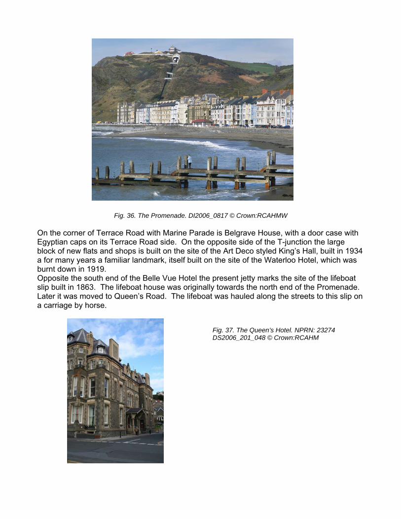
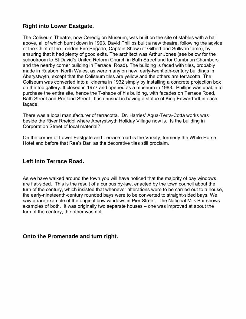
Fig. 36. The Promenade. DI2006_0817 © Crown:RCAHMW On the corner of Terrace Road with Marine Parade is Belgrave House, with a door case with Egyptian caps on its Terrace Road side. On the opposite side of the T-junction the large block of new flats and shops is built on the site of the Art Deco styled King’s Hall, built in 1934 a for many years a familiar landmark, itself built on the site of the Waterloo Hotel, which was burnt down in 1919. Opposite the south end of the Belle Vue Hotel the present jetty marks the site of the lifeboat slip built in 1863. The lifeboat house was originally towards the north end of the Promenade. Later it was moved to Queen’s Road. The lifeboat was hauled along the streets to this slip on a carriage by horse.
Fig. 37. The Queen’s Hotel. NPRN: 23274 DS2006_201_048 © Crown:RCAHM
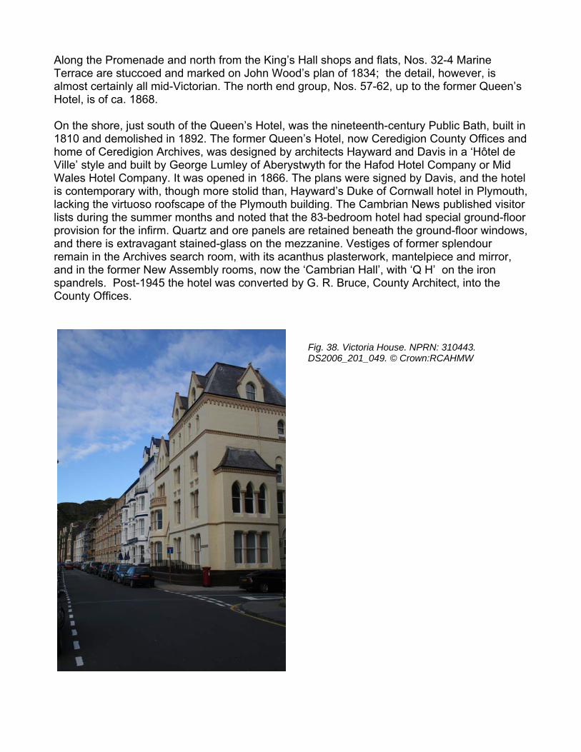
Along the Promenade and north from the King’s Hall shops and flats, Nos. 32-4 Marine Terrace are stuccoed and marked on John Wood’s plan of 1834; the detail, however, is almost certainly all mid-Victorian. The north end group, Nos. 57-62, up to the former Queen’s Hotel, is of ca. 1868. On the shore, just south of the Queen’s Hotel, was the nineteenth-century Public Bath, built in 1810 and demolished in 1892. The former Queen’s Hotel, now Ceredigion County Offices and home of Ceredigion Archives, was designed by architects Hayward and Davis in a ‘Hôtel de Ville’ style and built by George Lumley of Aberystwyth for the Hafod Hotel Company or Mid Wales Hotel Company. It was opened in 1866. The plans were signed by Davis, and the hotel is contemporary with, though more stolid than, Hayward’s Duke of Cornwall hotel in Plymouth, lacking the virtuoso roofscape of the Plymouth building. The Cambrian News published visitor lists during the summer months and noted that the 83-bedroom hotel had special ground-floor provision for the infirm. Quartz and ore panels are retained beneath the ground-floor windows, and there is extravagant stained-glass on the mezzanine. Vestiges of former splendour remain in the Archives search room, with its acanthus plasterwork, mantelpiece and mirror, and in the former New Assembly rooms, now the ‘Cambrian Hall’, with ‘Q H’ on the iron spandrels. Post-1945 the hotel was converted by G. R. Bruce, County Architect, into the County Offices.
Fig. 38. Victoria House. NPRN: 310443. DS2006_201_049. © Crown:RCAHMW
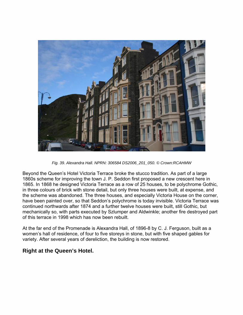
Fig. 39. Alexandra Hall. NPRN: 306584 DS2006_201_050. © Crown:RCAHMW Beyond the Queen’s Hotel Victoria Terrace broke the stucco tradition. As part of a large 1860s scheme for improving the town J. P. Seddon first proposed a new crescent here in 1865. In 1868 he designed Victoria Terrace as a row of 25 houses, to be polychrome Gothic, in three colours of brick with stone detail, but only three houses were built, at expense, and the scheme was abandoned. The three houses, and especially Victoria House on the corner, have been painted over, so that Seddon’s polychrome is today invisible. Victoria Terrace was continued northwards after 1874 and a further twelve houses were built, still Gothic, but mechanically so, with parts executed by Szlumper and Aldwinkle; another fire destroyed part of this terrace in 1998 which has now been rebuilt. At the far end of the Promenade is Alexandra Hall, of 1896-8 by C. J. Ferguson, built as a women’s hall of residence, of four to five storeys in stone, but with five shaped gables for variety. After several years of dereliction, the building is now restored. Right at the Queen’s Hotel.
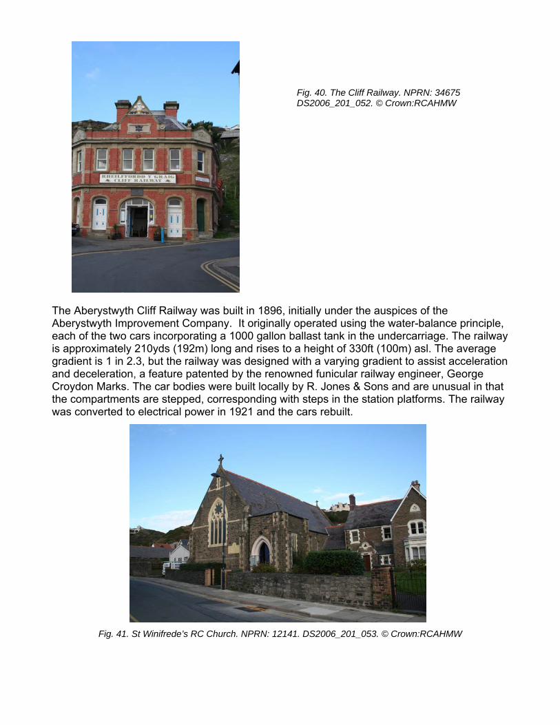
Fig. 40. The Cliff Railway. NPRN: 34675 DS2006_201_052. © Crown:RCAHMW
1896, initially under the auspices of the ginally operated using the water-balance principle,
each of the two cars incorporating a 1000 gallon ballast tank in the undercarriage. The railway is approximately 210yds (192m) long and rises to a height of 330ft (100m) asl. The average gradient is 1 in 2.3, but the railway was designed with a varying gradient to assist acceleration and deceleration, a feature patented by the renowned funicular railway engineer, George Croydon Marks. The car bodies were built locally by R. Jones & Sons and are unusual in that the compartments are stepped, corresponding with steps in the station platforms. The railway was converted to electrical power in 1921 and the cars rebuilt.
n:RCAHMW
The Aberystwyth Cliff Railway was built in Aberystwyth Improvement Company. It ori
Fig. 41. St Winifrede’s RC Church. NPRN: 12141. DS2006_201_053. © Crow
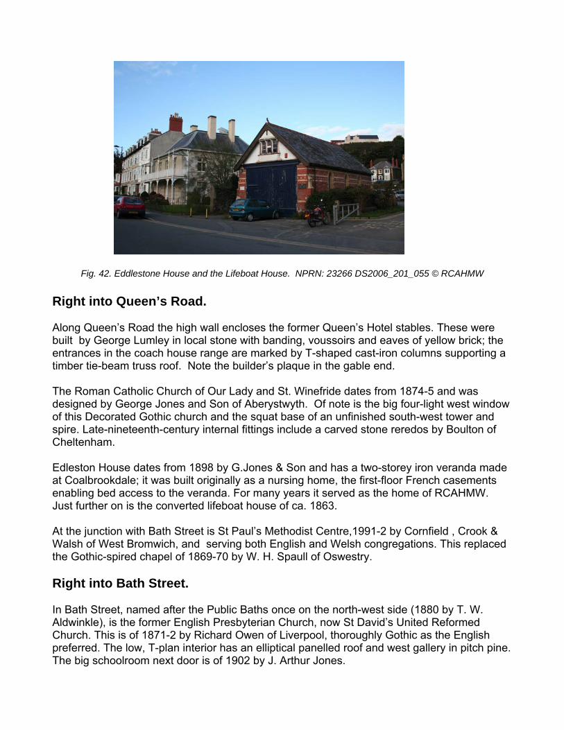
1_055 © RCAHMW Right into Queen’s Road. Along Queen’s Road the high wall encloses the former Queen’s Hotel stables. These were built by George Lumley in local stone with banding, voussoirs and eaves of yellow brick; the entrances in the coach house range are marked by T-shaped cast-iron columns supporting a timber tie-beam truss roof. Note the builder’s plaque in the gable end. The Roman Catholic Church of Our Lady and St. Winefride dates from 1874-5 and was designed by George Jones and Son of Aberystwyth. Of note is the big four-light west window of this Decorated Gothic church and the squat base of an unfinished south-west tower and spire. Late-nineteenth-century internal fittings include a carved stone reredos by Boulton of Cheltenham. Edleston House dates from 1898 by G.Jones & Son and has a two-storey iron veranda made at Coalbrookdale; it was built originally as a nursing home, the first-floor French casements enabling bed access to the veranda. For many years it served as the home of RCAHMW. Just further on is the converted lifeboat house of ca. 1863. At the junction with Bath Street is St Paul’s Methodist Centre,1991-2 by Cornfield , Crook & Walsh of West Bromwich, and serving both English and Welsh congregations. This replaced the Gothic-spired chapel of 1869-70 by W. H. Spaull of Oswestry. Right into Bath Street. In Bath Street, named after the Public Baths once on the north-west side (1880 by T. W. Aldwinkle), is the former English Presbyterian Church, now St David’s United Reformed Church. This is of 1871-2 by Richard Owen of Liverpool, thoroughly Gothic as the English preferred. The low, T-plan interior has an elliptical panelled roof and west gallery in pitch pine. The big schoolroom next door is of 1902 by J. Arthur Jones.
Fig. 42. Eddlestone House and the Lifeboat House. NPRN: 23266 DS2006_20
Left along the Church Surgery Alley to Portland Road.
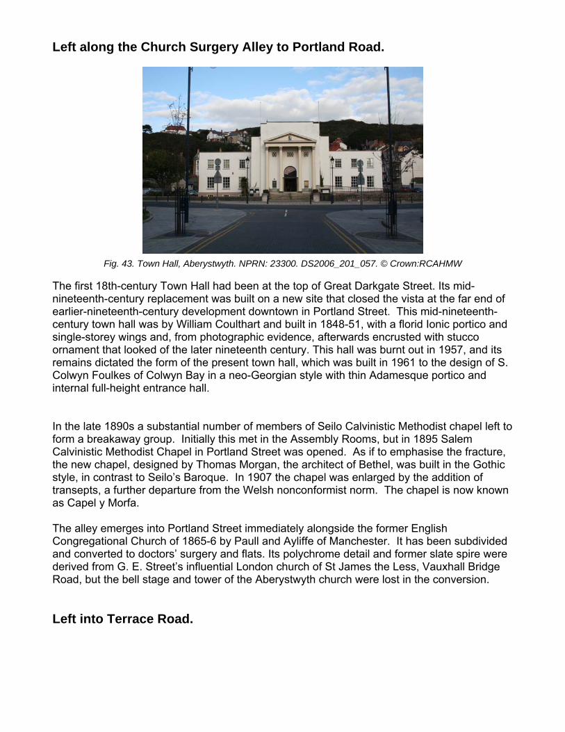
Fig. 43. Town Hall, Aberystwyth. NPRN: 23300. DS2006_201_057. © Crown:RCAHMW The first 18th-century Town Hall had been at the top of Great Darkgate Street. Its mid-nineteenth-century replacement was built on a new site that closed the vista at the far end of earlier-nineteenth-century development downtown in Portland Street. This mid-nineteenth-century town hall was by William Coulthart and built in 1848-51, with a florid Ionic portico and single-storey wings and, from photographic evidence, afterwards encrusted with stucco ornament that looked of the later nineteenth century. This hall was burnt out in 1957, and its remains dictated the form of the present town hall, which was built in 1961 to the design of S. Colwyn Foulkes of Colwyn Bay in a neo-Georgian style with thin Adamesque portico and internal full-height entrance hall. In the late 1890s a substantial number of members of Seilo Calvinistic Methodist chapel left to form a breakaway group. Initially this met in the Assembly Rooms, but in 1895 Salem Calvinistic Methodist Chapel in Portland Street was opened. As if to emphasise the fracture, the new chapel, designed by Thomas Morgan, the architect of Bethel, was built in the Gothic style, in contrast to Seilo’s Baroque. In 1907 the chapel was enlarged by the addition of transepts, a further departure from the Welsh nonconformist norm. The chapel is now known as Capel y Morfa. The alley emerges into Portland Street immediately alongside the former English Congregational Church of 1865-6 by Paull and Ayliffe of Manchester. It has been subdivided and converted to doctors’ surgery and flats. Its polychrome detail and former slate spire were derived from G. E. Street’s influential London church of St James the Less, Vauxhall Bridge Road, but the bell stage and tower of the Aberystwyth church were lost in the conversion. Left into Terrace Road.
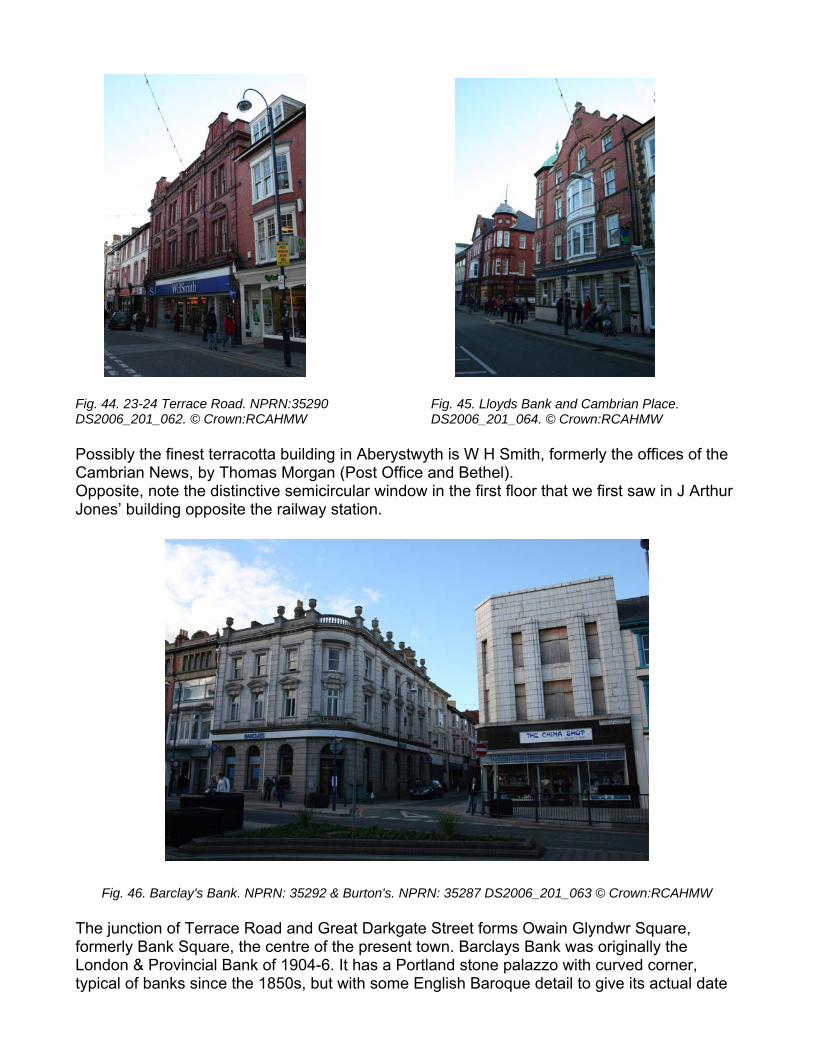
Fig. 44. 23-24 Terrace Road. NPRN:35290 DS2006_201_062. © Crown:RCAHMW
Fig. 45. Lloyds Bank and Cambrian Place. DS2006_201_064. © Crown:RCAHMW
th is W H Smith, formerly the offices of the
rgan (Post Office and Bethel). rcular window in the first floor that we first saw in J Arthur
Fig. 46. Barclay's Bank. NPRN: 35292 & Burton's. NPRN: 35287 DS2006_201_063 © Crown:RCAHMW
Possibly the finest terracotta building in AberystwyCambrian News, by Thomas MoOpposite, note the distinctive semiciJones’ building opposite the railway station.
The junction of Terrace Road and Great Darkgate Street forms Owain Glyndwr Square, formerly Bank Square, the centre of the present town. Barclays Bank was originally the London & Provincial Bank of 1904-6. It has a Portland stone palazzo with curved corner, typical of banks since the 1850s, but with some English Baroque detail to give its actual date
away. Opposite, the distinctive white-cladded art-deco style betrays the building as a former Burton’s store of the 1930s! The buildings on the other two corners are characteristic Edwardian corner buildings: Laura Ashley’s with a spirelet; Siop y Pethe with red brick Dutch gables and a cupola. Proceed towards the railway station. No. 20, Caffi Morgan, retains its original mosaic fascia, with “Jukes Draper” in green letters on a gold background. Lloyd’s Bank, further down, is dated 1902 and is of red brick and terracotta, with corner cupola. Cambrian Chambers, of red brick and plentiful terracotta, also dating from 1902, is possibly by J. Arthur Jones. This perambulation is merely a walking introduction to this fascinating and interesting Welsh coastal town. There is of course, much more of architectural interest in Aberystwyth. Enjoy your walk around the town.. These notes originally written to accompany a tour of Aberystwyth by the Victorian Society. They were compiled by David Percival, with additional information from David Browne, Geoff Ward, Olwen Jenkins and Julian Orbach, W.J.Lewis (Born on a Perilous Rock) and the National Monuments Record of Wales.