Embed Size (px)
Citation preview

-----~SL\T:~~ L;' ,- J i
UN;'fEU 2: ,',;',: :~:= '
___D_C_"_:'::L_}/_"::'_:'\_'.;_~:_----Jil
UlJrCi}'
An Archeological OverviewofRedwood National Park
Michael J. Moratto
Publications in Anthropology, Number 8
Cultural Resources Management DivisionWestern Archeological CenterNational Park ServiceTucson, Arizona

To Earnest L. Cassel, my grandfather -Del Norte County pioneer, woodsman, sawyerand avocational historian -- this paper iswarmly and appreciatively dedicated.
M.J.M.11/1/73
iii

Contents
Dedication
Illustrations
Preface and Acknowledgements
I Introduction
II Linguistics in Northwestern California Prehistory
III Ethnographic Background
IV Ethnohistorical Notesby Patricia Parker Hickman and Michael Moratto
V Previous Archeological Research in Northwest California
VI Archeological Sampling within Redwood National ParkThe Enderts Beach SiteThe Stone Lagoon Site
VII The Archeological Reconnaissance of Redwood National Park
VIII Inventory of Cultural ResourcesIn and Near Redwood National Park
IX Conclusions and Recommendations
Bibliography
v
iii
vii
ix
1
3
10
37
51
696974
79
87
99
103

Map 1 : Distribution of native languages in northwest California~1ap 2 : Areas surveyed in the nOrthern portion of the parkMap 3: Areas surveyed in the southern portion of the park
Figure 1 : Artifacts from the Gunther Island siteFigure 2 : Artifacts from the Patricks Point siteFigure 3: Artifacts from the Patricks Point siteFigure 4: Artifacts from Tsurai
Summary data on survey work in the park
r' ,, ,Ii
Plate I:Plate II:Plate III:Plate IV:Plate V:Plate VI:Plate VII:
Table 1:
Illustrations
Yurok family house at Re'kwoiNoledin, a Chilula villageBone harpoon points from the Point St. George siteArtifacts from the Point St. George siteStone artifacts from Del Norte County sitesBone and antler artifacts from the Enderts Beach siteArtifacts from the Stone Lagoon site
Table
vi
48081
52S4SS57
22236163717277
84

Preface
This overview was written in 1973 as a report to the National ParkService, entitled "A Survey of Cultural Resources in and Near RedwoodNational Park, California." Minor editorial changes and the deletion ofprecise site-location data have been made for the purposes of this publication.
Acknowledgements
Compiled here are data gathered during three seasons of fieldwork(1971-1973) in and near Redwood National Park, California. The projectwould have been impossible without the assistance of many persons. I amdeeply grateful to the following individuals and organizations for theirgenerous efforts on behalf of the Redwood National Park ArcheologicalProject:
Arcata Redwood Company (Orick)--Eugene Hofsted (Director, Orick office) and Lou Tirado (Field Representative); California Department ofParks and Recreation--Francis Riddell (State Archeologist); Humboldt StateUniversity (Arcata)--Rudolph Becking (Forest Research Consultant); SanFrancisco State University--Patricia Hickman (graduate archeologist),Thomas Jackson (graduate archeologist) and Paul Schumacher (Director,Treganza Museum); Frederick Burk Foundation for Education (San Francisco)-Lawrence Eisenberg (Director), Roy Heidtman (Director of Research) andDick Judy (Contracts Officer); Simpson Lumber Company (Arcata)--CharlesEvers and H. A. Peterson, Jr.; University of California, Berkeley--Alb~rt
Elsasser (Director of Archeology, Lowie Museum) and Robert Heizer (Professor of Anthropology); University of Hawaii (Honolulu)--Richard Gould (Professor of Anthropology); individuals--Amelia Brown (Tolowa, Smith River)and Thomas King (research archeologist, Santa Rosa).
People in various offices of the National Park Service played essential roles in our study: Western Archeological Center (Tucson)--KeithAnderson (Chief, Division of Internal Archeological Studies); John Bancroft (Editor) and Sally Tobola and Vonna Lou Mason (Typists); RedwoodNational Park--John Davis (Superintendent), Linda Finn (Naturalist), HomerLeach, Edie Nielsen and Steve Veirs; Western Regional Office--Astrid Schenk(Environmental Planner) and Garland Gordon (Chief, Interagency Archeologi:al Services); and Washington Office--Douglas Scovill (Chief Archeologist).
vii

I: Introduction
Cultural resources, such as historic and prehistoric archeological
sites, are among the features of Redwood National Park. These resources
are protected by the provisions of the 1906 Act for the Preservation
of Antiquities, the 1935 Historic Sites Act, the 1969 Environmental
Policy Act, Executive Order 11593 regarding the "Protection and
Enhancement of the Cultural Environment" and by other measures. In
order to design a program for the preservation and interpretation of
the cultural features in Redwood National Park, the National Park
Service has sponsored detailed studies of the local history and arch
eology. The former topic is comprehensively described in History
Basic Data: Redwood National Park, by E. Bearss (1969). The archeo
logical study, based upon three seasons of library research and field
reconnaissance, provided the data for this overview.
The chapters dealing with linguistics and archeology (II, V and
VI) endeavor to reconstruct the arrival and evolution of prehistoric
cultures in the vicinity of Redwood National Park. Materials from
these chapters may be abstracted directly for interpretive purposes.
More importantly, however, the assessments of the archeological
status quo form a perspective for evaluating the significance of
the archeological features which remain within the park and for
generating anthropological questions which might be answered through
field investigations in the future 0
Chapters III and IV deal with the ethnography and ethnohistory
of the native peoples--Yurok, Tolowa and Chilula--of the Redwood
National Park vicinity as they were known during the historic period.
These chapters attempt to depict the aboriginal lifeways as they
existed before AD 1800 and to recount memorable incidents in the
painful era of inter-cultural hostilitieso The information pre
sented in these chapters should be useful in interpretive programs.
Certainly an understanding of the archeology, ethnography and ethno
history of the north coast Indians will contribute greatly to an
appreciation of the role of ~fan in the redwoods; never was nan's
1

1:I:I
: '
II.
I I
relationship with this environment more harmonious than when the
Indians alone held the rivers and seashore.
My bbjectives in Chapters VII and VIII are to describe the
field reconnaissance of Redwood National Park and to inventory the
various archeological features discovered. Nearly 21 square miles
of land were covered on foot between 1971 and 1973, resulting in the
discovery of nearly two score sites or previous site locations. Eac}
site is described in terms of its nature, condition and significance.
Chapter IX provides recommendations for preserving, managing and
interpreting the archeological resources described.
2

: i \.: , .
3
II: Linguistics in Northwestern California Prehistory
! '
J
There are three main ways in which linguistics can illuminate prehistory: (a) by establishing facts concerningthe common origin and subsequent divergence of languages,implying the earlier unity and subsequent separations of'peoples; (b) by discovering diffused features (of phonetics,structure, or vocabulary) among languages, which bear evidence of prehistoric culture contacts; and (c) by reconstructing the vocabulary of old stages of language in orderto bring out suggestions of the physical environment andcontent of prehistoric cultures. (Swadesh 1959: 20)
..... v __ •
\~
The Distribution of Native Languages in Northwest California
Six separate languages were spoken by the historic Indians of
" California's northwest coast culture sub-area (Map 1). The terrii
, tories of these people coincided almost exactly with stream drain-
c..J~'" ages: (1) Smith River and the adjacent ocean frontage were held by
':: the Tolowa (Drucker 1937; Waterman 1925); (2) immediately south,"f"
". the Yurok occupied the lowermost dozen miles of Redwood Creek, a
40-mile stretch of the coast and the entire Klamath River watershed
'<~' downstream from the mouth of the Trinity River (Kroeber 1911, 1925;~~;. ..
'" Waterman 1920); (3) Karok boundaries included the Klamath River
Basin upstream from its confluence with the Trinity River (Bright
1957; Kroeber 1925); (4) the Hupa claimed the lower Trinity River,
an elongate valley parallel to the middle Redwood Creek homeland of
the Chilula (Goddard 1911, 1914a, 19l4bj Kroeber 1925) and (6)
Wiyot lived along the coast around Humboldt Bay, just south of
The purposes of this chapter are (1) to describe the linguistic
territories of northwest California and (2) to develop a hypothesis,
based upon lexico-statistics, to account for the ethnographic diver
sity in the region. As a device for reconstructing the probable
lji sequence of population movements into this part of the state, parti1! ' cular attention will be given to the problem of establishing the
approximate dates at which languages diverged from their parent
'i' stocks.

I '
i
..I,
MILES
o 5 10 15I , I I
",
Map 1. Distribution of nilanguages in northwestCalifornia.
NEW RIVEFSHASTA l:
1ill:L'HUPA " ~
I E~
,-rrirtf ~~\CHIMARIKO :-c" 1,'-2, ,~-, '
<.TOLOWA
REDWOOD NATIONAL PARK
ALGONQUIAN LANGUAGE FAMILY
HOKAN LANGUAGE FAMILY
ATHABASCAN LANGUAGE FAMILY
PENUTIAN LANGUAGE FAMILY
POI NT ""----~
SAINTGEORGE
fWd&l(:~: ~: j: ~:~: ~: (: j:j:::::::::IIITIIIIIIJ]]I II I
, I
i
I: ,If
;,,, ,'II, I,II' ,
I!I, IiI I
, Ii :;1
1'
, '
I:,

the Yurok (Dixon and Kroeber 1913; Loud 1918; Nomland and Kroeber
1936; Teeter 1964).
These groups represent three language families: Athabascan
(Tolowa, Hupa and Chilula), Hokan (Karok) and Algonquian (Yurok
and Wiyot) (Dixon and Kroeber 1919; Voegelin and Voegelin 1966).
The California Athabascan languages are closely related to Navajo
and Apache of the southwestern United States and to Kutenai,
Chipewyan, Galice, Beaver and other languages of sub-arctic and
boreal Canada (Hoijer 1956; Hymes 1957). Karok has its nearest
ties with six scattered groups of other Hokan languages in Nevada,
California and Mexico (~f. Heizer and Whipple 1971: Map 1; Kroeber
1925). Yurok and Wiyot number among their Algonquian kin such
northeastern American tongues as Menomini, Cree, Fox, Ojibwa and
Algonquin (Bloomfield 1946; Reichard 1926; Sapir 1913; Voegelin and
Voegelin 1966).
Although the external relationships of California's Athabascan
and Hokan languages have been accepted since 1900, much controversy
has attended the placement of Yurok and Wiyot within the Algonquian
familyo Early in this century Dixon and Kroeber (1913) and Sapir
(1913) demonstrated the connection between Yurok and Wiyot and
assigned these languages to the "Ritwan family" of the "Algonquian
stock." Michelson (1914) and others contested this, initiating a
long debate in American linguistics. Ultimately, both Yurok and
Wiyot were intensively restudied in order to clarify their relation
ships with other languages (Robins 1958; Teeter 1964). This work
has shown unequivocally that the "Ritwan" languages belong to the
Algonquian family (Haas 1958).
Time-Depth of Northwest California Languages
More than 30 years ago Voegelin proposed a relative chronology
of American linguistic phylao Reasoning that internal diversity
could be used to indicate time-depth, Voegelin (1945: 232-233)
inferred the following temporal ordering:
5

(Early)
eLate)
Hokan-Siouan (25 families; 60 languages)Penutian (16 families; 29 languages)Algonquian-Wakashan ( 8 families; 50 languages)Na-Dene (Athabascan) ( 4 families; 33 languages)Uto-Aztecan-Tanoan ( 4 families; 19 languages)Eskimo-Aleut ( 2 families; 4 languages)
Voegelin further assumed that "a broken distribution implies
more elapsed time than a smooth, continuous distribution" (1945: 233),
but he did not attempt to develop a temporal ordering based upon
this criterion.
These approaches are inconclusive when applied to the languages
of northwestern California. There is, of course, no certainty that
the North American relative chronology holds, even approximately, for
smaller regions; even if Voegelin's early-to-late Hokan-Algonquian
Athabascan ordering correctly sequences North American arrivals,
the appearance of member languages in California may have followed
a different pattern. The criterion of "broken distribution" also
gives ambiguous results. While it may be that an older, continuous
distribution of coastal Athabascans was disrupted by a more recent
incursion of Algonquian speakers, it is possible that the Athabascans .
came later and settled around established Algonquians (Map 1). The
first reconstruction (ioe., disruption of Athabascans by Algonquians)
does seem more plausable on one count: as measured by the great
diversity within coastal Athabascan (six languages with 14 dialects), :
compared with the relative homogeneity of Algonquian (two languages
with three dialects), the former would emerge as older in California
(cf. Heizer and Whipple 1971: Map 1).
A more fruitful approach to the matter of linguistic time-depth
is offered by glottochronologyo With this method, provisional dates
of language separation are calculated on the basis of percentages of
shared non-cultural cognates (cf. Gudschinsky 1964). An early glotto
chronological study indicated that Hupa had separated from the parent!
Athabascan family some 20 centuries ago and that California Hokan
speakers had diverged from their linguistic relatives as much as 5S
6

centuries ago (Swadesh 1954: 362). ~bre conservative dates were
calculated by Hoijer, who suggested that the Pacific Coast languages
broke off from the common Athabascan body around 1000 to 1300 years
ago (Hoijer 1956: 231).
Using Hymes (1957) data, I calculated 1062 years to be the
average (X) separation among the sampled California Athabascan groups
(i.e., Hupa, Kato and Mattole). The arrival date of Athabascans in
California may approximate the calculated time of their divergence
from the Canadian Athabascans. Using Hymes' (1957: 292-293) infor
mation for 21 language pairs, I computed 1231 years ago as the (X)
provisional time for this separation. Thus, Hymes' detailed analysis
suggests that the Pacific Coast Athabascan split from the northern
branch around AD 742, a date entirely consistent with Hoijer's
(1956) estimate of 1000 to 1300 years ago. The calculated date of
1062 years, or AD 911, for the divergence among California Athabas
cans is also in harmony with this reconstruction.
Ancillary data concerning the relative ages of native California
languages were provided by Klimek's (1935) matrix cluster analysis
of ethnographic traits. Using a coefficient of association (Q6)'
Klimek (1935: 22 ff.) quantified the degrees of similarity among '60
"tribes" and clustered them into "strata." Each stratum was then
shown to be connected with a specific linguistic group. Noting that
"the definition of the ethnical nature of particular strata permits
us to determine the nature of the historical facts which they repre
sent", Klimek (1935: 61) developed an "historical sequence of Cali
fornia Indians." Klimek's mathematical analysis of non-linguistic
traits led him to conclude that (1) the Hokan-related stratum was
the most ancient in California and (2) the Athabascan and Algonquian
migrations occurred very late in the sequence (Klimek 1935: 64).
Although Klimek may be faulted for assuming that high levels of
shared cultural traits indicated common times of sociolinguistic ori
gin (as between Northwest Coast Algonquian and Athabascan speakers),
it should be noted that his sequence agreed in most respects with
the subjective impressions of Kroeber (1935). The Northwest Coast
7

culture pattern was assumed to be more ancient by Kroeber (1935: 8),
but both scholars agreed fully that the "Hokan stratum" was much
older than the stratum associated with Algonquian or Athabascan.
In retrospect, it would appear that near-complete diffusion of
cultural traits among the Northwest Coast groups had masked the
diversity of their origins in Klimek's study.
Cultural blending apparently was accompanied by extensive
genetic mixing on the Northwest Coast. The following passage from
Hulse (1960: 51) is illustrative:
Certainly one cannot maintain that the Hupa resemble, intheir blood-type frequencies, the other Athabascans ••••one suspects, the influence of Northwest Coast culture,even in attenuated form, led to such extensive and longcontinued intermarriage that the original Hupa gene-poolmerged into another, larger one long ago.
Summary
There are adequate data to postulate a schedule of prehistoric
population movements into northwestern California. The Hokan speake
are considered to be the most ancient, both in California (Klimek
1935; Kroeber 1935) and in the remainder of North America (Voegelin
1945). Their presence in California is thought to date earlier
than 5500 years ago (Hopkins 1965; Taylor 1961), a view consistent
with the glottochronological dates of 5500 years ago for the earlies
divergences among California Hokan languages (Swadesh 1954).
The Athabascan immigration occurred relatively late in Californ
prehistory (Klimek 1935; Kroeber 1935). Glottochronology variously
places the Athabascan entry at 2000, 1000-to-1300 and 1200 years ago
(Swadesh 1964; Hoijer 1956; Hymes 1957, respectively).
It is generally accepted that the Algonquian speakers were
also late arrivals in California (Klimek 1935; Kroeber 1935), but
no glottochronological studies are available to fix the absolute
age of California Algonquian. Nevertheless, the criterion of inter
nal diversity does suggest that Algonquian is at least several cen
turies younger than Athabascan. The best order and probable ages
8

for the relevant ancestral languages in northwestern California,
therefore, would be:
Proto-KarokProto-Hupa/Chilula/TolowaProto-Yurok/Wiyot
9
(-55 centuries?)(-12-13 centuries?)(- 9-10 centuries?)

"
il
1'1
I,I II,
J .i
III: Ethnographic Background
There are many fascinating accounts of the cultures of the
Tolowa, Yurok and Chilula Indians, who once lived in the area now
within the Redwood National Park. It is my intent here to review
the aspects of northwestern California etlmography which may be
germane to National Park Service interpretive and resource manage
ment programs. With present-day foci on ecological topics, park
planners and visitors alike will be interested to learn how the
Indians coped with the redwood wilderness.
Specific purposes of this chapter are: (1) to identify points
of anthropological interest in and near Redwood National Park and
to provide data concerning their significance; (2) to sketch the
ancient life-ways of the Indians in the vicinity of the park so as
to provide the National Park Service with information useful in the
preparation of interpretive exhibits and literature; (3) to documen"
the salient cultural activities of aboriginal northwest California
as a stimulus for the Park Service to encourage the perpetuation
of native practices for the benefit of local Indian people and the
edification of park visitors, and (4) to review a wide range of
technical sources in the hope that this chapter will serve as a key
resource for non-specialists who may wish to research ethnographic
matters in more detail than can be provided here. Toward this end,
an extensive bibliography has been appended to this report.
The Northwest California Culture Area
As a culture area, northwest California included the territori
of the Yurok, Tolowa, Hupa, Karok, Wiyot, Chilula and Chimariko (cf
Map 1), as well as the more southerly Whilkut, Nongatl, Mattole,
Lassik, Wailaki and Sinkyone (cf. Heizer and Whipple 1971: Map 1).
Although each of these cultures was distinctive in speech and certa
customs, they shared the fundamentals of the northwest coastal phil
sophical and socio-economic patterns. In particular, these groups
were adapted to riverine, littoral and forest environments. Their
10

subsistence was based upon the taking of salmon, shellfish and pinni
peds--activities which contrast rather sharply with the terrestrial
hunting-gathering economy of central California Indians (Kroeber
1925, 1939; Baumhoff 1963). Accordingly, Beals and Hester (1960)
have included the "tribes" of northwestern California in their
"Riverine" and "Coastal Tideland Gatherers" ecologic types.
Relative to other California culture areas, the northwest area
is marked by numerous idiosyncratic traits. Among these are split
wooden-plank houses and sweathouses; wooden.dugout canoes; carved
wooden pillows, acorn mush paddles, and boxes; emphasis upon wealth,
with Dentalium shell money and certain "treasure" items; twined
basketry caps and receptacles; special adzes, mauls, antler chisels
and wedges for woodworking; carved elkhorn spoons with fancy handles;
tubular tobacco pipes with wooden shafts and stone bowls, and carved
antler purses for shell money. The north coastal Indians were also
known for their minimal political organization and for their parti
cipation in the World Renewal religious cult (Heizer 1951b; Kroeber
1925; Kroeber and Gifford 1949).
Demographic Notes
Because of the rugged topography and dense forests which charac
terize the Klamath Mountains, Indian settlements were customarily
located along the coast or on river banks. Small streams seem to
have been virtually unoccupied, and the hinterlands served only for
deer hunting, gathering firewood and collecting acorns, berries and
seeds. Permanent inland villages were situated on riverine terraces
well above winter flood levels. On the coast, the shores of lagoons
or sheltered streamsides were most often selected as habitation
places (Drucker 1937; Kroeber 1925; Waterman 1920, 1925).
Settlements of northwest California seem to have been of three
types: major villages, small hamlets and temporary encampments. The
first-order villages were recognized as places where there were many
houses, where important ceremonies were held and where especially
wealthy men resided (cf. Drucker 1937; Kroeber 1925). Subsidiary to
11

these villages were nearby hamlets of several houses each; often
these had been settled by overflow from the main village. The
third class of settlements included camp sites, which were occupied
seasonally for special activities, such as smelt fishing or acorn
harvesting (Gould 1966a),
Although one might suspect that a degree of political cohesion
would have united the villages with their tributary hamlets, Kroeber
(1925: 16) stressed that:
, •• since there was no definite community sense within avillage, there was no opportunity for a larger or politicalcommunity to develop out of a group of adjacent villages.One settlement in such a group--"a suburb"--was sometimesinvolved in a feud mlile another directly across the riverlooked on. Of course, wherever kinship existed, it formeda definite bond between towns as within them; .••
Ethnographic accounts of Yurok settlements report one to 22
houses per village, in addition to sweathouses. The reconstructed
averages for settlements of all sizes and kinds would be 7.5 persons
per house, six houses per town and about 45 persons per tO~l (Kroeber
1925: 17). That these figures probably apply to other north coastal
groups is supported by data from the Tolowa area, where 14 villages
had an average of 5.5 houses each (Drucker 1937).
Tolowa Settlements
Since the first listing of Tolowa Village names appeared in
Hodge's (1910) Handbook, many other scholars have reported upon
aspects of Tolowa demography. The works of Curtis (1924), Gould
(1966a), Drucker (1937) and Waterman (1925) are especially valuable.
The following list combines data from all of these sources and pre
sents the various orthographies which have appeared in print over
the years. Preferred spellings follow Drucker's (~937) usage.
(1) Xa/wunhwut (also Hawinwet, Hmrunkut, Khoonkhwuttunne,
Xawinwet or Siesta Peak Rancheria)--on the north bank of Smith
River; destroyed by settlers in 1853; rebuilt on an island; 13
12

houses and three sweathouses; two divisions, "upriver" and "down
river," each centered around the house of a rich man (Curtis 1924;
Drucker 1937; Kroeber 1925; Waterman 1925).
(2) Ya' ta/ :kut (also Yontakit, Yotokut, Ataakut, Y6!!t/ akit or
Yontucket Rancheria)--on the old Burnt Ranch, north of Lake Earl;
a large number of To10wa people were massacred here by white settlers
in 1853; seven houses, two sweathouses and a sacred sweathouse; two
divisions, "on the hill" and "oceanward" (Drucker 1937; Kroeber 1925;
Curtis 1924; Waterman 1925).
(3) Tro/:let--a small suburb of Y~ ta/:kut (Drucker 1937).
(4) rvlu/nsantun (also Munsontun)--on the east bank of Smith
River; site of an annual salmon weir; one house, occupied by a man
from Y~ ta/:kut (Drucker 1937).
(5) Kehasli/' hwut (also Kehoslihwut)--an "old site" on the
east bank of Smith River; three houses and an above-ground men's
sleeping house; reinhabited from Ya'ta/:kut (Drucker 1937).
(6) MI/litcuntan (also Melishenten)--on Smith River at a for
mer weir site; one house on each side of the river and one sweathouse
(Drucker 1937; Kroeber 1925); probably the hamlet named Minitce/nten
by Waterman (1925).
(7) Si'tragf"/tum (also Stragitum) --an "old site" on the west
bank of Smith River, inhabited by a man from E/:tcTIlet; one house
and one sweathouse (Drucker 1937).
(8) Tcunsu/ltun--on the north bank of Smith River; two houses
and a sweathouse; a suburb of Ta/:tatun (Drucker 1937).
(9) Te/:nltcuntun (also Tenitcuntun)--"at the foot of the
trail"; no data on number of houses (Drucker 1937).
(10) 1vluslye'/ --abandoned in 1937; said to be a suburb of
Y~ta/:kut (Drucker 1937).
(11) Tunme:/tun--on the south bank of the Middle Fork of
Smith River; two houses; a suburb of Ya'ta/:kut (Drucker 1937).
(12) Tcestu/mtun (also Chestltshtun)--on the west bank of
the South Fork of Smith River, east of Crescent City; two or three
houses; most inhabitants were slain in a feud during historic times;
13

i!I,
i I
I: i :
1
""':,1
,
:,,' I
! 1
I
~'; !I !
1<1:1:II'"I ! 1
", ,
I, i
! I.
the survivors moved in with relatives at Ta/:tatun (~urtis 1924;
Drucker 1937).
(13) Na/kutat--on the north bank of the South Fork of Smith
River; a suburb of Ta/tatun (Prucker 1937),
(14) E/:tculet (also Echulet, Echulit, Aichulet, E/tculet or
Lake Earl Rancheria) --on the edge of Lake Earl; a large to\'l11 noted
for its wealth; 11 houses and four sweathouses (~urtis 1924; Hodge
1910; Drucker 1937; Kroeber 1925; Warburton and Endert 1966).
(15) Tucracku/ctun (also Tatrghatkustan) --on the shore of
Lake Earl; nine houses and two sweathouses; offshoot of E/:tculet,
established after a quarrel over whale rights ca. 1850 (J) (~urtis
1924; Drucker 1937; Waterman 1925).
(16) T'aYi/a/te (also T'ai'(a?n, T/agiatun, Targhinaatun or
Point Saint George Rancheria)--"pointing seaward"; an extremely
large prehistoric town, occupied by 300 BC; used historically as a
camping place for shellfish gathering and sea lion hunting; depopu
lated early in the historic period by an epidemic, possibly of
cholera (Curtis 1924; Drucker 1937; Gould 1966a; Waterman 1925).
(17) Ta/tP/ tun (also Tatin tin) --northern end of Pebble Beach;
abandoned early in the 20th century; possibly a suburb of Ta/:tatun
(Drucker 1937; Kroeber 1925; Waterman 1925).
(18) Mesl te/ltun (also Metel ting, l"estethltun, Mesl teln or
Pebble Beach Rancheria)--near the southern end of Pebble Beach; a
weal thy satellite of Ta/: tatun; nine houses and t,% sweathouses
(Curtis 1924; Drucker 1937; Kroeber 1925; Waterman 1925).
(19) Ta/:tatun (also Tatlatunne or Tata/ten)--a village at
Crescent City; moved in historic times to Senf/gxat (~urtis 1924;
Drucker 1937; Waterman 1925).
(20) Senf/gxat (also Seninghat, Se/:ninhat or Crescent City
Rancheria)--at the site of Seaside Hospital in Crescent City; occu
pied historically by people from Ta/: tatun; 11 houses and two
sweathouses (Drucker 1937; Kroeber 1925; Waterman 1925).
(21) Sxme? (also Cushing or Cushion)--a hamlet along Cushing
Creek; occupied during the mid-19th century; one house and a sweat-
14

house (Moratto 1972). Bearss (1969: Plate 1) refers to this Cushing
Creek village as "Nec-Kah." This designation apparently is incorrect;
it may be a misplaced reference to Neke/l, which was the Yurok name
for the village (No. 22) at Nickel Creek (Drucker 1937; t-1oratto 1972:
22). Gould (1966a: 25) states that Nos. 21 and 23 are the same.
(22) ThniYatYo (also Shinyatlchi, Cinya/lcri, Cinya/tltci or
Nickel Creek Rancheria)--on the north bank of Nickel Creek; "summer
fishing" place; at least two houses and a sweathouse; abandoned about
1880 (Boratto 1972; Waterman 1925; Kroeber 1925).
(23) Ltru/cme--south of No. 22; a suburb of Ta/:tatun \'1ith two
or three houses (Drucker 1937).
(24) Ta/geslsa:tun--along Wilson Creek, on both sides of the
stream; a village with both Tolowa and Yurok residents; Drucker gives
almen as the Yurok name for this site, but Waterman (1920) shows
a1menhipur as the village at Wilson Creek and almen as a village 1/2
mile further south (Waterman 1920: Map 6).
(25) Sastaso"/ --"spoon holder," a settlement on Point Saint
George; no data on houses (Waterman 1925).
Yurok Settlements
The Yurok inhabited the banks of the Klamath River from Bluff
Creek, a few miles above Trinity River, to the ocean and along the
coast from Trinidad to the mouth of Wilson Creek (Curtis 1924). The
-54 named Yurok towns either were clustered around lagoons and the
mouths of streams or were strung out along the Klamath River; there
were no villages on smaller streams deep in the forest. The river
towns were situated on old terraces, usually 100 feet or more above
the stream. In the winter of 1862 a tremendous flood destroyed
many villages and forced the Yurok to relocate in new, higher places.
Settlements frequently were moved-for other reasons, including
disease, attacks by enemies, bad dreams and feuding (Waterman 1920:
201-204).
Early lists of Yurok village names were compiled by Randall
(1866) and NcKee (1952; cf. Heizer 1972, 1973). Curtis (1924) and
15

IiI'III';1
"il
I'!i
Kroeber (1925) published excellent synopses of Yurok culture, including
data on settlements, but the nost comprehensive treatment available
is Waterman's (1920) Yurok Geography. Using Waterman's orthography,
I describe here the principal Yurok settlements in and very near
Redwood National Park.
(1) O/menhipu/r--"O/men down river"; on Wilson Creek; seven
or eight house pits were visible in 1914 on both sides of the creek,
but there was no appreciable accumulation of shell (Kroeber 1925;
Waterman 1920). Refer to Waterman's (1920) Map 6./ ~"~(2) a men (also Amme or Amen)--on the coast near Lagoon
Creek; the most important settlement in the vicinity; four houses
and one sweathouse; at the time of Waterman's visit there were
extensive accumulations of shell, less than 18 inches deep, "much
eroded by wind and wave"; a spring in the sand just east of the
village provided drinking water (Curtis 1924; Kroeber 1925; Waterman
1920: 230-231)./
(3) Re/kwoi (also R~q~ i or Requa)--"creek mouth"; an exten-
sive village of 22 to 25 houses along the Klamath River near a small
spring; Re/kwoi was important ceremonially as one of the places
where the Jumping Dance was held; at least one sacred dance house
was located at this village (Randall 1866; Curtis 1924; Waterman
1920). Kroeber lists Weltkwau, Tsekwetl, Pegwolau and Keskitsa as
suburbs, and Tmeri and Otwego as somewhat doubtful separate villages
(1925: 10). A map of Yurok house sites at Re/kwoi is given by
Waterman (1920: Map 8).
(4) We/lkwaw (also Weltkwau, lVetlko, Wekeswah or Wehlku )--a
town situated across the river from Re/kwoi; nine houses are reported;
a few house frames were still standing before 1920, but modern barns
and outbuildings occupied much of the former village site; in this
town lived an Indian \vith extremely valuable fishing medicine (Randall
1866; Curtis 1924; Waterman 1920). We/lkwaw was one of a half-dozen
Yurok villages with a sacred sweathouse where White Deerskin or
Jumping dances could be performed (Kroeber 1925: 10).
16

17
(5) Tse/kwel (also Otwego) -- on the south bank of the Klamath
River; Tse/kwel means "flat place in front of a bluff;" no data regarding
houses (Kroeber 1925; Waterman 1920)./
(6) Ho/:>paw (also Hoppaw, Hoppeu, Ho'pau or HaCpau) -- on the north
bank of the Klamath River; a small but wealthy town of four houses; a
smallpox epidemic all but decimated this village in the early historic
period; one wealthy woman in this town was cremated, along with her house,
in compliance with her last request (Randall 1866; Kroeber 1925; Curtis
1924; Waterman 1920)./
/ J " v c(7) Wo ke 1 (also Wokkel, Wakhel, Wohkel, Wakhkel or Wahke 1)
"pepperwood"; on the Klamath River opposite No.6; two or three houses;
this site was destroyed by flood before 1920 (Curtis 1924; Waterman 1920).
(8) Sa/ :>a1 (also Sa/ aihl or Sa/ aitl) -- "spirit people"; located
on the Klamath River's north bank opposite TIT/rip; Sii/:>iil was an impor
~tant town of seven houses, with one or two very wealthy families; the
town was thought to be inhabited by spirits, as well as by human beings
(Kroeber 1925; Waterman 1920)./
(9) TIT/rip (also Tarep, Turip or Turwrep) -- one of two towns on a
"fine redwood flat;" this town contained eight houses and three sweat
houses (Randall 1866; Curtis 1924; Kroeber 1925; Waterman 1920).
The many additional Yurok villages upriver from TIT/rip are not de
scribed here because of their distance from Redwood National Park. Lo
cations and cultural details for these settlements are given by Kroeber
(1925) and Waterman (1920)./ " .j(10) 0 segen (also Osegen, As/eghen, Ashegen or Ossagon)--on the
north bank of Ossagon (or Ojagon) Creek; a small town with three houses
and two s\l1eathouses (Curtis 1924; !Croeber 1925; Waterman 1920); two sweat
houses were still visible in the meadow north of the creek in 1935 (Hood
1965)./ W ".f ""/ /(11) E spa (also Eshpeu, Espav
, Aspau or A spa w) --on the coast
near Espa Lagoon; an important town of four to seven houses; many resi
dents of r:/spaw had relatives in the towns of the lower Klamath River and
\'there were direct trails between the two areas; the town was occupied
fllntil early in the 20th century and has accumulations of shell "severaltt~:·~,
I~t,~'~~.'~
~~{!':

yards thick" (Curtis 1924; Kroeber 1925; Waterman 1920).
(12) Otmekwo/r--at the edge of Redwood Lagoon; an old site with
five house pits visible in 1920; possibly the site from which the inhabi
tants of Ore/q~ originated (Waterman 1920)./
(13) O-re/qW (also Orek~ Araq or ArekW)--near Redwood Lagoon; this
was the most important town in the neighborhood; in 1920 there were traces
of six houses, a sweathouse and a cemetery; this was one of the villages
at which the Jumping Dance was held; the early population of O-re/qW is
estimated to have been 25 to 35 persons (Waterman 1920).
(14) Hr/gwr)W (also Hergwer or Plepe/i)--at the edge of Stone Lagoon;
seven houses and two sweathouses are reported for this site; during the
early l860s Chilula Indians from Bald Hills raided this village and killed
10 people; the survivors moved across the lagoon and settled at Tsa/hpekw
(Kroeber 1925; Waterman 1920)./
(15) Tsa/hpekw (also Tsapek or Tsa/p. aq) --at the edge of Stone Lagoon;
11 house names were recorded; this site was occupied until about 1935
(Moratto 1970, 1972; Waterman 1920).
(16) Tso/tskwi--at the edge of Dry Lagoon; an old site, possibly
with as many as 12 houses and two sweathouses (Waterman 1920).
(17) Tmr/i--an old village site; no data on houses; the American
town of Requa rests squarely upon this place (Waterman 1920).
(18) Si/gwets (or Cigwe/tsu)--an old town site at the edge of Red
wood Lagoon; a suburb of O-re/qW (Waterman 1920).
(19) O-ra/~--on the west bank of Prairie Creek; a camp site with
a collection of shelters used while gathering acorns; the last outpost
of Yuroks on Redwood Creek (Waterman 1920).
Chilula Settlements
Goddard (19l4b) has documented the location of 28 Chilula villages
and camps along the Redwood Creek drainage. All but one of the perman
ent villages were situated on the northeastern bank of this stream; the
temporary (summer) camps were to be found on the higher "prairies" and
hills on both sides (Kroeber 1925: 137). The Chilula are said to have
been traditional enemies of the Teswan (i.e., Coast Yurok) and the heavily-
18

""ooded region separating their villages was a pI ace of danger (Goddard
1914b)~ Kroeber ()925: 137) estimated that the average Chilula village
'was home to about 30 people.
Chilula sites of relevance to Redwood National Park are listed below.
(1) XOwUnnakut (or Ho~nnakut)--on a small flat east of Redwood
,Creek; the lowest Chilula village recorded by Goddard (.l914b); several
possible housepits were visible in 1914 (Goddard); if Goddard's (;9l4b)
map is correct, XOwUnnakut would have been in the vicinity of Counts Hill
Prairie. In passing, it should be noted that Waterman (1920: 262) men
tioned the Chilula village of Otlep as being the first settlement upstream
from Yurok territory; Otlep may be a Yurok name for XowUnnakut.
(2) Noledin (or Noleding)--a village on the northeast bank of Red
wood Creek upstream from No.1; this large settlement was occupied until
1888, when the last residents moved to Hoopa Valley. Both this village
site and that of XOwUnnakut possibly lie in or near the National Park.
Goddard (19l4b: 273) noted:
The village derived its name, and perhaps its existence,from a nole, or waterfall, a short distance up the stream.The creek bed was formerly choked with huge boulders,causing a fall, which was jumped by the salmon with difficulty. The fishing for both lamprey and eels, carried onwith nets below the fall, was excellent.
Important information regarding Noledin was received in a letter from
R.W. Becking of Arcata to the Director of the Cultural Resources Section
of the California Department of Parks and Recreation in Sacramento. In
part, this letter reads:
In 1972, a study was made of the Chilula Indian tribe whichinhabited the middle portion of the Redwood Creek drainage.According to accounts by Pliny E, Goddard ()9l4), a nunberof Indian villages were visited in 1906 ••• One village,"Nolemdin," was described as , •• above a waterfall in Red-wood Creek , •• Some 5-6 house pit sites were discovered ".and two stone hearths erected on the site later by the miners,Contact was made through Dr. Thomas Parsons with the HoopaIndians and two aged women were found who have lived at Nolemdinand were anxious to go to the former site and identify three
,J' grave sites .•• Nolemdin seemed also to have been the largestl; permanent Chilula village and is in close proximity to the Red-
19

II1 !I;I,·
il!i
iiiIiI'
II!
wood National Park. (Becking 1973: 2-3)
(3) Lotcimme--a village upstream from N6ledin and east of Redwood
Creek; site of an old lamprey weir; housepits were visible on the northel
edge before 1914; probably outside the Redwood National Park boundary lci
Goddard 19l4b: 273).
(4) Yltsinneakuttciff--a temporary camp site west of N6ledin; this
camp was occupied by Indians from the main village ~1en they were gather
ing tan oak acorns (~oddard 1914b).
(5) Lotsxotdawillindiff--a temporary camp site east of Noledin (Godt
19l4b).
(6) Fort near LotciTMae:
On the east side of Redwood Creek ••• above N6ledin theruin of a fortification was examined. It was quitehidden in the redwood timber .••• A house had beenbuilt of large redwood logs put together horizontallyin the form of a square, like a log cabin. There werefour logs still in place, one above the other. Thebottom logs, which were the larger, were about one anda half feet in diameter. Loop holes were made between thelogs. Dan Hill said the roof, supported by a post inthe center, was of split redwood planks. The door inthe middle of the western wall was of tan oak planksabout four inches thick. The floor was almost three feetbelow the surface of the ground outside. A small log houseformerly stood south of the blockhouse and a house hadstood near the creek. Among others, Tom Hill lived herefor some time in anticipation of an attack by white people.The fortification, which was made during the trouble withwhite people, was never used. It is possible that thisstructure was copied from similar ones built by the whitepeople of the region, for the Indians of NorthwesternCalifornia seem not to have used fortifications of anykind. (Goddard 19l4b: 281)
The many additional Chilula camp and village sites upstream from
Lotcimme are described by Goddard (1914b). Since they fall outside the
National Park boundaries, no mention of them will be made here.
Houses
Northwest coastal houses were made of redwood or cedar p1ank~ split
from felled logs with antler wedges and stone mauls, Cross cuts were ma,
with fire, which was controlled with wet clay to prevent irregular burnt:,
20

21
are to be
facing "pp. Ji~:
Iii,
near a stream. a lake or the ocean so that the
Sweathous~s were usedwater after sweating.
Yurok sweathouses were built over a rectangular pit. about 9 feet"'j
~\rWide. 12 feet long and 4 feet deep. The \Valls of the pit were lined with
i;:heavy planks. which were cut to form a gable about 2 feet above ground
\level on the ends. A ridge pole was set into the end planks and thick
':roof boards were laid between the ridge and the earthen side walls. Sweat
1houses were always located
;,men could plunge into cold:::l
;,~for ritual, social and medicinal sweating, but they also served as dormi~~: '
~:tories for men and older boys (Warburton and Endert 1966: 74-75; Heizer
ri9S1b: Fig. 32).~1:if::~.':' Kroeber (1925: 140) made the following observation on Chilula housing:
The Chilula built the typical north\vestern plank house andsmall square sweathouse in their permanent village. Theywere the most southerly Athabascan tribe to use this type ofsweathouse. In addition. two villages contained large rounddance houses of the kind charaCteristic of the region to thesouth, but not otherwise known in northwestern California.
e rough plank was then dressed \Vith an adze (Heizer 1951b).
Yurok houses were rectangular in plan, measuring about 20 to 24 feet
,~~ide by 30 to 36 feet long. The vertical wall planks, 1 to 3 feet wide":U'.?~'.
;~~1nd up to 4 inches thick, were secured to horizontal plates with withes orrt{~~~·~,;:rope. The truncated-gable roof was formed of three rows of planks: one.~;?;
~frilitched to the right, one to the left and one nearly horizontal rowan'~l~~ .:~;~~top. ThIS tripartite roof was supported by four heavy stringers set intokfb1'::~~notches in the end-wall siding planks. A circular doorway, which could be[;1;;,:"
~~~hut with a board, was cut into one of the end-wall planks, near the groundfE}','~~(and next to a corner (Plate 1). About half of the enclosed area was occu-,,'~::.'j,,:';
1:pied by a rectangular pit, 2 or 3 feet deep, wi thin which the fire pit
f':'~as centered. The earthen "deck" between the pit and the wall was used
::for the storage of firewood, food baskets, fishnets and other household.>.~:
'effects. Certain parts of this deck \Vere reserved for sleeping and were£~/ .,,~furnlshed with matresses of woven tules or the skins of deer, elk or "pani~:i:
~~1.ther" (mountain lion) (Kroeber 1925; Heizer 1951b; Warburton and Endertf,~B;'~~966; Curtis 1924). Excellent photographs of such structures~~~ :
~!ound in Warburton and Endert (1966: 45-46) and Curtis (1924:
/52 and 54).~,~, .

22
Plate I. Yurok family hosue at Re'kwoi on the north bank of theKlamath River. The house has been reconstructed and is
maintained by the Del Norte County Historical Society. An exactreplica was created in 1976 at the Wattis Hall of Man.
California Academy of Sciences, San Francisco .
Ii,
, 1ij ~
I ~II, ,!I
,1~.j~~
,[:1<~$
~II
I
I: IIj:
1: Ii.: if
,I:
i
. :"

A
23
~p
t~~~J;''::.~
B'
~f;-
a~~ 8~;.'~~;
ft FIG. XV: Noledifi, a Chilula village near Redwood Creek. (A) Remnantof a stone fireplace at Noledifi. (8) Hollow redwood trees north of the
if site which were used as shelters by the Chilula (see Chapter III).

I.I
In addition to the "standard" residence and sweathouse, the Chilula,;
are reported to have made brush-covered summer houses at their temporary'
camps. They also apparently used hollow redwood trees (Plate II) as eph
eral shelters during inclement weather (Goddard 1914b: 271). In most reo
spects, Chilula dwellings must have been similar to those of the /iupa,
which are described by Goddard (1903a: 11-17). Good photographs of /iupa
or Chilula dwellings are published in Kroeber (1925; Plate 13), Goddard
(1903a: Plate 2) and Curtis (1924: facing pp. 12 and 14).
Detailed accounts of Tolowa houses are given by Curtis (1924), DrucJ
(1937: 234-236) and Gould (1966a: 22-27). Tolowa dwellings differed fror!
their Yurok counterparts, in that they tended to be square, their gabled:
roofs had only two slopes and their entrance holes were more commonly
square than round. Tolowa sweathouses were subterranean, like Yurok
sweathouses, but the former were covered with a single-pitch shed roof,
which in turn was buried beneath a thick mantle of earth. Gould's (1966a\
Plate 2 depicts such a sweathouse. .
Boats
Typical canoes of northwest California are illustrated in Heizer
(1951b: Fig. 12), Kroeber (1925: Plates 5, 13), Warburton and Endert
(1966: 84), Kroeber and Barrett (1960; Plate 5) and Curtis (1924: facing,fI
pp. 26, 44 and 78). '
Prior to the construction of a canoe, the Yurok held a special dani
and sang a boat-making song. A redwood tree about 5 feet in diameter
would then be chosen for felling, a tedious enterprise which might take fl
six months. Another six months could be consumed as the canoe took form:
under the wedges, adzes and gouges used for carving (Warburton and Ende~
1966: 67-70). In contrast to this account, it was asserted by Kroeber
(1925: 83) that fallen trees or drift logs were customarily used and tha
fire was used to excavate the canoe's interior. Kroeber provides these'
details:
The Yurok t~)e of canoe, \~hich waS made also by the Tolowaand Wiyot and sold to the Hupa and Karok, is dug out of halfa redwood log, and is a clumsy but symmetrical and carefullyfinished vessel. It is used on the ocean, but is obviously a
24
'Ii.i

~'.':
k
type devised for a rushing river full of rocks. . .. the roundbelly of the boat and its gradually curving underside, withoutstem, allow a single stroke of the steersman I s paddle to swingit as on a pivot, and in the rapids many a rock is approachedhead on and then shot by so close that the hand could reach it .....The paddle ... is a combination of pushing and sweepingimplement, a stout pole 6 to 8 feet long, spreading below to anarrow, heavy blade, and used by standing men. Only the seatedhelmsman holds a true canoeing paddle (Kroeber 1925: 82-83).
c·~, Northwestern canoes averaged about 18 feet in length, 3 to 4 feet of
beam and 10 to 18 inches deep (Kroeber 1925: 83). The dimensions of a
iurok canoe at Orleans were: length, 18 feet 2 inches; beam, 3 feet 8
Lnches; bow width 3 ·feet 1 inch; depth amidships 1 foot 5 inches (Curtis
1924: 39). Larger sea-going canoes were apparently in use during recent
:imes to haul goods between Requa and Crescent City (Warburton and Endert
1966: 67-70). All canoes were equipped with carved footbraces for the
IOwsman and with both bootbraces and a carved seat for the steersman
~Kroeber 1925).
The Tolowa canoes described by Drucker (1937) are essentially the
;ame as those made by the Yurok, except that some Tolowa boats were much
arger. Powers (1877: 169) saw on Humboldt Bay one of these sea-going
anoes, which he said was made on Smith River and which measured 42 feet
IT length and had a beam of 8 feet 4 inches. It was capable of carrying
4 men or five tons of freight ecf. Kroeber and Barrett 1960: 126). Drucker
tates that the Tolowa made five-man "sea lion boats," which were up to
.5 fathoms (-27 feet) long, 3. feet deep and 1 fathom af beam (Drucker
937: 237). This description is certainly consistent with Amelia Bro\~'s
ecollection that "four or five" Talowa "boys" and "two or three" sea
ions could fit in one of the canoes stationed at TsiniYa~a (Amelia Brown
g72: personal communication).
The Chilula are said not to have employed watercraft (Kroeber 1925).
Ibsistence Activities
Diversity characterized both the subsistence technology and the
Lnge of resources utilized by the north coast Indians. Fishing and
lllecting shellfish were emphasized in the native economy, but hunting,
25
ti,;'i,'
, "..

fowling and gathering floral products were also quite important. The
resources of the northwest coast were so abundant that the Indians of the
area were able to attain some of the highest levels of population density
and cultural complexity known among food-gathering peoples anywhere. It
should be pointed out, however, that although the northwest coast area
produced literally tons of salmon, sea lion, \vhale, deer, elk, bear and
waterfowl meat, these resources were available on a sporadic schedule and
there were times of privation or outright starvation (Suttles 1968: 56-58).
Many techniques \'Jere developed to store surplus food for later use.
Fish were smoked or dried in the sun; clams were steamed and dried; dried
acorns, nuts, seeds, berries and seaweed were stored in baskets or boxes,
and sea mammal meat and certain fish were rendered for oil, then hung
within the family house to dry. Other foods, such as mussels and salmon
berries, could not be preserved and had to be eaten fresh (Drucker 1937;
Gould 1966a; Suttles 1968; Kroeber 1925).
The best accounts of native fishing practices in northwest California
are given by Hewes (1942, 1947), Kroeber and Barrett (1960) and Rostlund
(1952). Both marine and freshwater species of fish were taken with a great
variety of nets, spears, leisters, hooks, harpoons, traps, weirs and poisons'
(cL Bennyhoff 1950; Drucker 1937; Kroeber 1925; !Croeber and 13arrett 1960;
Hewes 1947), The main riverine fishes sought by the Indians were king or
Chinook salmon (Oncorhynchus tschawytscha), coho or silver salmon (0. kisutc
red or sockeye salmon (0. nerka), steelhead (Salmo gairdnerii), white sturg~,
(Acipenser transmontanus), green sturgeon (A. medirostris), lamprey eel ~
(Endosphenus tridentatus) and several varieties of suckers (Catostomus
spp.) CKroeber and Barrett 1960). Of marine fishes, the Tolowa, at least,
are known to have taken soupfin shark (~aleorhinus zyopterus), Pacific
hake (Merliccius productus), Pacific halibut (Hippoglossus stenolepsis),
redtail surfperch (Holconotus rhodoterus), striped seaperch (Taeniotoca
lateralis), bocaccio (Sebastodes paucispinis), yellowtail rockfish
(Sebastodes flavidus), black rockfish (~ebastodes melanops), vermilion
rockfish ($ebastodes miniatus), turkey-red rockfish (Sebastodes ruberrimus);,I
lingcod (Ophiodon elongatus), kelp greenling (Hexagrammos decagrammus),
Cabezon (Scorpaenichthys marmoratus) and red Irish lord O-Iemilepidotus
26

~ilepidotus) (Gould 1966a: 85). Photos of native fishermen have been
published by Curtis (1924) ~ Warburton and Endert (1966) and Krqeber and
Barrett (1960).
Sea mammals were highly prized for food in northwest California,
especially by the Tolowa. Both the Yurok and the Tolowa respected indi
vidual ownership of stretches of beach where sea lions could be harpooned
or where beached whales could be processed. Whales were not hunted on the
sea, but seals and sea lions were taken regularly (cf. Driver 1939; Hewes
1947; Kroeber 1925). Accounts of sea lion hunting are given by Warburton
md Endert (1966: 111-113) and by Kroeber and Barrett (1960; 116-117).
n1e Yurok hunted sea lions
... on the rocks, about six men going out in a boat. Three orfour of these might bring deerskin blankets, or sometimes abearskin because some sea lions are black. These men landedon the rock to act like sea lions and attract them; the othersstayed in the boat, off to one side, out of sight .... When thoseleft there saw sea lions coming, they began to sway and crawland shout like them, to persuade the sea lions to cone up close.Meanwhile they got their harpoons ready; and when a sea lionwas near enough, all the men cast their harpoons at the sametime •.•. The sea lion would drag off whatever harpoon he wasstruck by. Then the boat came close to the stack and tookoff the hunters, and they looked about for the sea lion toemerge •... Two of the men in the boat stood ready with morespears ... Sometimes the animal had to be struck five times before it was killed .... Usually they did not attempt to harpoona large sea lion when the sun was getting low, because thebig ones took a long time to kill and sometimes dragged theboat far out into the ocean ... Morning was the right time tospear big ones, because it might take up to half a day tokill them. A good sized sea lion cannot be taken into theboat; holes were punched through its lips and flippers, andthen it was towed back to land. (Kroeber and Barrett 1960:116-117)
Not fewer than six species of sea mammals were represented in the
rcheological remains at the Point Saint George site; whale (sp. 1),
te11ar sea lion (Eumetopias jubata), California sea lion (~alophus
aliforianus), harbor seal (phoca vitulina), northern fur seal (Callo
hinus ursinus) and sea otter (Enhydra lutra) (Gould 1966a).
In addition to sea mammals, shellfish were staples in the diet of
he Tolowa and Coast Yurok. Excellent data regarding the exploitation of
olluscan resources by the northern California peoples are recorded by27

Driver (1939), Gould (1966a), Ilewes (1947) and Kroeber and Barrett (1960).
Among the species collected were the ocean mussel (r.1ytilus californianus),
abalone (HaIiotis refescens and [1. cracherodii), Washington clam (SaxidoJilu5
nuttallii), common Ii ttleneck (Protothaca staminea), heart cockle
(Clinocardium nuttallii), razor clam (Siliqua patula), gaper (Tresus
nuttallii), rock scallop CHinni tes giganteus), barnacles (Balanus sp.),
sea urchin (Strongylocentrotus purpuratus), giant chi ton (Cryptoc~liton
stelleri) and various crabs (Cancer spp.) (Gould 1966a; Kroeber and Barrett
1966).
Although many types of resident and migratory birds occur in the
northwest coastal region, they seem not to have been exploited in propor
tion to their abundance. TIle Talowa customarily got young cormorants
(Phalacrocorax sp.) from their nests before they could fly (Gould 1966a:
85). Geese, ducks, scoters, coots, gulls and pelicans were probably also
taken for food, although the ethnographies are vague in terms of slJecies
identification. It is certain that pileated woodpeckers (Dryocopus pileatl
and acorn woodpeckers (Melanerpes formiciverous) \vere killed for their red
crests (Kroeber 1925; Gould 1966b; Drucker 1937).
All of the north coastal groups seem to have held private tracts
of land for hunting and collecting. Animals were secured in traps or
snares or were shot with arrows. Important food creatures included deer
(Odocoileushemionus), elk (Cervus canadensis), black bear (Euarctos
americanus), racoon (Procyon lotor), coyote (Canis latrans), rabbits
(Sylvilagus spp.), hares (Lepus spp.) and mountain lions (Felis concolor)
(Gould 1966a; Drucker 1937; Kroeber 1925; Curtis 1924; Suttles 1968).
A nunber of autllors have described the seasonal round practiced
by the Indians of the north coast. These data may be synopsized as
follows:
Spring: Chinook and silverside salmon and sturgeon caught in rivers
and creeks; certain roots and berries collected in late spring; hazel
shoots gathered for Inaking baskets; young greens aathered; eels trapped;
various land mammals hunted; clams dug.
SUl1hl1er: Ferns, beargrass and hazel shoots gathered for baskets;
blackberries, thimbleberries, salmonberries, huckleberries and raspberries
28
t:··
',".",
picked; deer, rabbits, etc. hunted; surf fishing (for smelt) in later
summer; hazel nuts collected; cormorant eggs and nestlings gathered;
foraging for seaweed, mOlluscs, abalone, etc.; some sea mammals hunted.
Fall: Special work groups left the main villages to gather acorns
and then to fish for Chinook and silver salmon; numerous plant foods
gathered, including hazel nuts, wild onions, camas, wild popatoes, chin
quapin nuts, huckleberries, manzanita berries, fern roots, soap root,
skunk cabbage roots, many kinds of grass seeds and pine nuts; quail, deer
and rabbits hunted; sea mammal lrunting continued.
Winter: Best sea lion hunting was in late winter/early spring;
waterfowl hunted; steelhead, candlefish, eels and sturgeon caught; deer
and elk hunted; most likely period for beached whales; economic pursuits
diminished and increased reliance placed on stored foods.
Additional details are provided by Suttles (1968), Warburton and
Endert (1966: 104-105), Gould (1966a: 88-92, 1966b), Drucker (J937:
231-235) and Kroeber 0925: 84-88).
Money and Wealth
Among the Indians of northwest California, all material items--baskets,
houses, tobacco, canoes, bows, etc.--had some recognized worth, but they
were not considered to be money or treasure goods Qlcizer 1951b; Kroeber
1925). Special treasures included white deerskins, red woodpecker scalps
and excessively large (up to 33 inches) flint and obsidian blades (Kroeber
1925: 26-28; Drucker 1937: 242). Dentalium shells, acquired in trade from
more northerly Indians and strung on fiber twine, functioned as money.
Kroeber (1925: 23) said that "the Yurok grade their shells very exactly
according to length, on which alone the value depends"; but Warburton and
Endert (1966: 86) observed that incised dentalia were worth a little more
than plain ones. Dentalia sizes and values are reported by Kroeber (1925:
23); the function of the shells is described by Drucker (1937: 240-241):
The uses of the dentalia were virtually the same as those ofour money. One could pay damages; hire a doctor to cure; buya magical formula, a canoe, a quiverful of arrows, or a danceheadband with the shells •••. The chief points of difference arethat the Tolowa currency counted for more in determining social
29

I
i,'I
I ;
status, and that it was not normally exchanged for the necessities of life.
Dentalia strings were measured against tatoos on the arms of men
(see Curtis 1924: facing p. 108). Illustrations of these wealth items
are widely available: Dentalia shells (~ould 1966b: 71; Curtis 1924:
facing p. 10); woodpecker scalp headband (Gould 1966b: 71); white deer
skins (Curtis 1924: facing pp. 30 &32; Heizer 1951b: Fig. 25; Kroeber
1925: Plate 3; Kroeber and Gifford 1949: Plate 2), and obsidian blades
(Curtis 1924: facing p. 34; Kroeber 1925: Plate 2; Gould 1966b: 73).
Kroeber (1925: 2) stressed the significance of wealth and the role
of wealthy men in maintaining social cohesion. In a later paper, DuBois
(1936: 50) made a distinction between "subsistence" and "prestige" econ
omies of the Tolowa:
By subsistence economy is meant the exploitation of the plentiful natural resources available to any industrious individual •.•. By prestige economy, on the other hand, is meant a series ofsocial prerogatives and status values ••.
Gould, in a comprehensive examination of The Wealth Quest Among the
Tolowa Indians, argued, instead, that subsistence and prestige economies
were inter-related on the northwest coast:
It will be shown that the quest for wealth among the Tolowahinged primarily upon the acquisition and disposal of women.The fact that the ultimate goal of an ambitious Tolowa manwas prestige (for which the possession of wealth was a prerequisite) has been amply demonstrated ••• What this paper willshow is that the workings of this quest for wealth--and ultimately prestige--were substantially different from what hasbeen previously suggested for these people. With certain modifications which will be described, Tolowa "treasures" wereall-purpose money. with women's labor serving as the link between the subsistence and prestige aspects of the economy(Gould 1966b: 68)
Following an exhaustive review of Tolowa economics, it was concluded
that:
While the exchange of subsistence goods (particularly food)for "treasures" was not an everyday affair, it neverthelesswas cornrnon ...• Given the fact that "treasures" could be and wereexchanged for food, it becomes easier to realize the basicimportance of a man's access to women's labor in his quest forwealth. The more women a man had working for him, the more
30

food he could expect to store--thus furnishing him with articles~Jhich could be exchanged for "treasures" and at the same timefurnishing a direct means of enhancing his prestige at feasts ...(Gould 1966b: 87)
Clothing and Ornamentation
Dress for women consisted of a skirt, about 26 inches long, made
of fringed buckskin or, less often, shredded maple bark. A t\Jined apron,
lavishly decorated \'1i th beads, shells and pine nuts, was worn over the
front of the skirt (cf. Curtis 1924 : facing p. 98). Finely-woven twined
basketry caps were worn almost constantly and necklaces of Dentalium
shells or other beads were Duch admired. All women were tatooed on the
chin with vertical strips running from the mouth downward (\/ar1)urton and
Endert 1966: 150-151; Curtis 1924: facing p. 100).
Men customarily wore a buckskin \"rap or breechclout. When hunting
in brushy country, leggins \vere indispensabl e. In winter or \vhen trekking
great distances, men and women wore moccasins. Both single-piece deerskin
moccasins and moccasins with extra elkhide sales were made. Blankets or
capes of animal fur augmented the standard dress in cold weather.
Illustrations of northwest coast Indian clothing are to be found
in Goddard (1903a: Plates 4 and 5) ; Heizer (1973: Figs. 1-4); Kroeber
and Heizer C1968 : Figs. 23, 24, 61, 73 and 98); Warburton and Endert
(1966 : 142), and Curtis (1924 : facing pp. 64, 72, 86, 92, 96, 93, 100,
102, 110 and 112).
Basketry
Chilula, Tolowa and Yurok women brought the craft of basl,et weaving
to a high degree of excellence. Aside for minor elements of finish, all
northwestern California basketry was made by the twining technique. Baskets
were twined of spruce, redwood, bullpine, sugarpine, alder, willow or wild
grape roots over warps of hazel, willow or myrtle sticks. Overlay ,vas
completed with wllite grass (Xerophyllum tenax), ferns or porcupine quills.
Special basketry forms were made for cooking, storage, grinding acorns,
carrying burdens and toting infants; there were also fish baskets, soup
baskets, dippers, water baskets, gift baskets, dance baskets and oasketry
31

:i
caps for women, all fashioned by twining. Fine examples of all these
types are illustrated by O'Neale (1932: Plates 5-58). Other north coast
baskets are to be seen in r~ason (1904: Plates 86, 88, 92, 96, 170 and 171)
and Goddard (1903a: Plates 20-27).
Miscellaneous r,laterial Arts
In addition to the many sorts of baskets and a considerablenumber of dance paraphernalia, nearly 100 different kinds ofimplements ... have been preserved in museums. Adding thosewhich went out of use before they were collected, it is safeto say that the group made at least 150 and perhaps 200 distinct types of utensils. This is evidence of a fairly richcivilization. (Kroeber 1925: 97)
Some of these implements include bows and arrows (Warburton and Endert
1966: 89-90; Schumacher 1951; Ray 1886; Pope 1962), musical instruments
(Curtis 1924; Kroeber 1925: 96), woodworking tools (Kroeber 1925; Goddard
1903a; Curtis 1924) and fishing tackle (Kroeber and Barret 1960; Hewes 194,
Bennyhoff 1950; Curtis 1924; Kroeber 1925). tlany details regarding culture:
material are given in the general summaries by Driver (1939), Flannery
(1939), Kroeber (1925), Curtis (1924), Warburton and Endert (1966), Goddarc
(1903a, 1914b) and Drucker (1937).
Tobacco and Smoking
Native tobacco (Nicotiana sp.) was the only plant cultivated by the
Indians of northwest California. A level place was prepared for cultiva
tion by covering it with spruce, fir and her-dock boughs, which were then
burned to ash. Wild tobacco seeds ItJere sown with the aid of a digging
stick early in the spring and the young plants were tended with care. Hen
customarily smoked their tobacco pipes in the sweathouses before retiring
(Warburton and Endert 1966: 88).
Shamanism
Among California's north coast Indians there developed a unique
complex of traits associated with shamanism. Customarily women, shamans
were persons who derived special power from the possession of a "pain" (a
pathological object with its own power) and the ability to control it.
32

33
There also was a special class of sorcerers:
Whereas some sorcerers are said to have practiced their evilart in secret, others openly boasted of their misdeeds. Usuallytheir reputation for invulnerability was sufficient to save themfrom retaliation, though modern firearms seem to have been moreeffective against them than aboriginal weapons. I have the notionthat often sorcery may have been an outlet for a thirst for recognition. It is certain that the wizard was greatly feared. (Drucker1937: 259)
Curing was accomplished by sucking the pain out of the patient during a
singing and dancing ritual (Drucker 1937; Kroeber 1925). Doctors' fees
were high and had to be paid in advance. One man is reported to have paid
$20 and a string of Dentalium shells for a cure; a particularly reputable
shaman is said to have consistently charged $100 per case (Warburton and
Endert 1966: 76-78). Detailed accounts of shamanism are given by Spott
and Kroeber (1951), Kroeber (1925), Curtis (1924: 43-46) and Drucker (1937:
257-259).
Mortuary Practices
Disposal of the dead by burial was the universal custom in north
western California, except that persons who had starved to death were
sometimes thrown into a river (Curtis 1924: 42; Gould 1963). A corpse
was retained in the family house for one to three days while kinsmen
assembled for the funeral. The body was then removed from the house
through a special opening in the wall; a corpse was never carried through
the regular door. In the cemetery, which was near the houses, a shallow
grave was prepared by a kinsman. Dentalium shells and broken wealth
items--obsidian blades, woodpecker scalp headbands, etc.--were placed
with the deceased in the board-lined grave. After the burial, poles were
erected at the grave site and were hung with baskets, dance costumes and
other valuables. After the funeral all persons associated with the burial
had to undergo ritual cleansing, lest they be contaminated by the death
(Curtis 1924: 42; Kroeber 1925: 46-47; Warburton and Endert 1966: 123;
Drucker 1937: 255-256; Gould 1963).
An absolute taboo is laid on the names of the dead; the violation
this constitutes a mortal offense, voidable only by a considerable
;.,

i :i "
payment (Kroeber 1925: 48; Curtis 1924: 42).
The property of the deceased was inherited by patrilineal relatives.
That which could not be used was burned rather than given to non-kinsmen
(Drucker 1937). llelatives were expected to show grief for about a year
after the funeral. This requirement was particularly binding upon widows,
who had to singe their hair, cover their faces with pitch and/or ashes and
generally refrain from social contacts for the mourning period.
Religion
The Indians of California's north coast region vigorously participate
in the World Rene\val Cult, one of three native ceremonial systems in the
state:
The esoteric magic and avowed purpose of the focal ceremoniescomprising the system include reestablishment or firming ofthe earth, first-fruits observances, new fire, prevention ofdisease and calamity for another year or biennium. These several motivations, some of which are explicit or alluded to ineach of the dozen local cults, appear to be conveniently suggested by our name "world renewal";... (Kroeber and Gifford1949: 1-3)
World Renewal ceremonies consisted of esoteric rites performed by a
priest or formulist, along with the White Deerskin and Jumping dances:
The two used different characteristic regalia--woodpeckerscalp headbands and dance baskets in the Jumping Dance;albino and other deerskins along with long flint and obsidian blades in the Deerskin. The prescribed steps \vere quitedifferent, and the songs can ahvays be told apart. (Kroeberand Gifford 1949: 3)
These sacred dances were held only in a few special locations, where
tradition and the availability of religious structures permitted them.
Among the villages which held World Renewal dances were Re/kwoi, We/lkwa";'
O-re/qW, Pekwan, Kepel and Weitspus CGurtis 1924: 47-48; Kroeber and
Gifford 1949: 2). The Chilula are reported to have held White Deerskin
Dances in prehistoric times also, but details are lacking (Goddard 19l4b:
272). Descriptions of the World Renewal dances are to be found in Kroeber
(1925), Kroeber and Gifford (1949), Woodruff (1892), Goddard (1903a) andCurtis (1924).
34

In addition to the dances associated with the World Renewal rites,
the Brush Dance was held by northwestern groups for the purpose of curing
children (Kroeber 1925; Kroeber and Gifford 1949).
Mythology
The rich mythologies of the various cultures relevant to this study
have been documented by Goddard (1903a, 1904, 19l4a), Drucker (1937),
Graves (1929), Kroeber (1908, 1925), Kroeber and Gifford (1949), Warburton
and Endert (1966), Waterman (1951), Curtis (1924) and many others. Only a
few comments on mythology will be offered here.
The Yurok seem to have recognized countless spiritual entltles, of/
which three were particularly important. w3.hpeku-mau was the creator and
a spirit who controlled natural resources, Pulu/kuhl-gerreg was character
ized as a spirit who could transform evil beings into harmless ones and
Coyote was the paragon of deceit, a trickster who often emerged victorious
(Curtis 1924: 54). Of the many Yurok myths, two will be recounted briefly
because of their relevance to the Redwood National Park vicinity.;I
Oregos: At the time of creation, Wahpl:lku-mau informed all spirits
that they could choose what they wanted to be. Oregos decided to be the
tall rock on the north bank at the mouth of the Klamath River (cf. Warburton
and Endert 1966: 33). To Oregos \vas given the responsibility of directing
the salmon into the river when spa\vning conditions were right. Oregos
also saved people from drowning and fishermen prayed to her for calm seas
(Warburton and Endert 1966: 14-16).
Nock Maye (Split Rock): Long ago, Nock Haye was a single great rock
on the coast a few miles south of the Klamath River. Nearby lived an
aging widower with his unmarried daughter of 20 years. When the old man
announced that his daughter wished to marry, a large nUJilber of single men
gathered at Nock Maye to compete for her hand. The bride, it was deter
mined, would go to the man who could cast his net into the sea and catch
the most fish. The men fished all day, but they caught nothing. Finally,
Beaver (Tesear) came along and entered the contest. After making fishing
magic, Beaver flung his great net into the sea as far as the sun, securing
the near end of his net to a stake driven into Nock Maye. So many tons of
35

fish were netted that the strain on the anchor stake split the rock.
Beaver was permitted to marry the girl and the split in Nock Haye may be
seen to this day (Warburton and Endert 1966: 23-25).
Tolowa myths were similar to those of the Yurok. There was a crea
tor (KWD'E le/cun) who was rather remote but who was prayed to, nonethe
less. There were supernatural serpents in every river and lagoon and
every sea lion rock was owned by a giant octopus, which ate people ~10
broke taboos associated with the rock. The Tolowa also believed fervently
in wood devils--wild hairy beings of human forEl--as well as benevolent
wood sprites (Drucker 1937: 267-268).
Miscellaneous Aspects of Social Organization
Space limitations prevent even an introduction to the complex and
fascinating matters of social structure, marriage, kinship, law and re
lated aspects of northwest coastal etlmography. These topics are well
described by Kroeber (1925), Goddard (1903a, 1914b), Drucker (1937) and
Curtis (1924).
36

by
37
IV: Ethnohistorical Notes
Patricia Parker Hickman and Michael Moratto
More than 170 years after Vizca{no's voyage, two vessels under the
The first voyage of exploration along the Alta California coast
occurred in 1542 under the command of Juan Rodriguez Cabrillo.
When Cabrillo died following an accident, his pilot, Bartolome
Ferrelo, pressed on northward as far as the mouth of Rogue River.
Because of the heavy storms ffilcountered in early 1543, Ferrelo
remained 70 or 80 miles offshore and made no contacts with the
natives of far northern California. The next outsider to visit the
area was Francis Drake. Although he closely skirted the Humboldt
County coast in 1579, no landfall was attempted until he was much
further south. In 1595 the Spanish Captain Cermeiio piloted his
Manila galleon San Agust{n across the North Pacific to Trinidad
Head, thence southward into Trinidad Bay and beyond. Fearing rocks,
Cermef10 did not anchor until he reached Drakes Bay. It was not
until 1603 that an explorer's journal mentioned Indians. In that
year Sebasti{n Vizca{no sailed northward as far as Lat. 43° and
noted the presence of Indians in boats made of "pine and cedar" at
a place which may have been the mouth of the Eel River. Hoping
to entice the sailors to visit them upstream, the Indians are said
to have offered acorns, nuts, fish and game (Coy 1929: 19-22; Bearss
1969: 17-21; Palais 1958: 7).
I~~:
. <.~' t;:~~;.;I;~~~',I,I The purpose of this chapter is not to duplicate the excellent syn
t:' thetic history of Redwood National Park by Bearss (1969), nor is it pos
i~ sible to introduce new primary data of the sort compiled in the regional~~ifi. studies by Coy (1929), Bledsoe (1881, 1885) and others. Rather, it is our
~ft.. intent to review the historical events which had a direct bearing upon the
!lives of California's north coast Indians.
\~. 1542I, 1603
I
II'f.~ti',.':'
~~

1817 In this year the British schooner Columbia arrived in Trinidad Bay
In active trading the sailors received furs, venison and berries i1
exchange for hoop iron cut into six-inch lengths. Notes on the
1792
1793
1803
1808
command of Bruno de Heceta made their way up the Alta California
coast. One of these ships, La Sonora, captained by Juan Francisco
de la Bodege y Cuadra, put into Trinidad Bay and remained there
from June 9th to 20th. Yurok Indian customs were noted, including
the fact that iron implements \~ere already in use (~urtis 1924:
39-40; Palais 1958: 8; Coy 1929; 13-23; Bledsoe 1885; 50),
In April, 1792, the English Captain George Vancouver explored the
area around Cape J~endocino and returned the following year to look
for Trinidad. His ships anchored in Trinidad Bay from May 2nd to
5th, while his sailors spent two days on shore exploring and study
ing the natives (Palais 1958: 9; Bancroft l890).
Between 1803 and 1805 the Russians reconnoitered the Humboldt Count
coast with the ultimate objective of finding a location suitable f(
occupation. At about the same time, on I-lay 11, 1804, the American
ship Lelia Byrd put into Trinidad Bay. Trade commenced with the
local Indians, but as they grew more numerous Capt. William Shaler
decided to weigh anchor before trouble developed. The following
year, American Captain Johnathan Winship arranged with Governor
Baranov of Sitka to take 100 Aleuts on a sea otter hunting expedi
tion to California. Winship's vessel, the O'Cain, appeared in
Trinidad Bay on June 11, 1805, whereupon a vigorous trade in furs
with the Indians was undertaken. As a conflict with the Indians
began to materialize, Winship left Trinidad on June 22, but he
continued to work the coastal otter colonies during the following
years. In 1809, when the Russian Kuskov landed at Trinidad, he
found that the sea otter populations had been decimated and that
the local Yurok villages were abandoned. CPalais 1958: 10; Bearss
1969: 26-27; Coy 1929: 29).
38

39
(Yurok) Indians included the facts that their "daggers" were made
of stone. the women ,yore fine "leather petticoats" and leather
capes. shell ornaments were used to embellish the clothing and
women were adorned with chin tatoos (Bearss 1969: 28).
1828 Encumbered with a herd of 300 half-wild horses and mules. Jedediah
Smith and his small band of mountain men became the first Caucasians
to penetrate the redwood 'vilderness by an overland route. During
their peregrinations. Smith and his men discovered the river that
now bears his name and carne to visit the plank lodges of the Hupa
on Trinity River. After exceedingly arduous trekking do\m to the
Klamath. Smith induced some Yurok near Kepel, with gifts of razors
and beads. to ferry the trappers across the river. About two weeks
later. with his band near starvation. Smith purchased lamprey eels,
mussels and other foods from enterprising Yurok traders on High
Prairie Creek. The Indians later returned with dried fish, clams.
"seagrass mixed with weeds" and blubber. r~oving north\vard along
the coast. Smith's party made camp at "Nec~Kah" near the mouth of
Cushing Creek (probably Sxmef or Tsini'( af'.a; see Chapter lIT). Press
ing northward to Elk Creek. Smith encountered Tolowa Indians. who
supplied him with fish. clams. strawberries and camas roots. From
the Elk Creek camp. Smith skirted Lake Earl and traveled along the
coast until he reached the Umpqua River. 'vhere his company was
drastically reduced by the Indians (Bearss 1969: 31-39; Palais
1958: 11).
1828- During the two decades following 1828 sporadic parties of fur trap
pers entered northwest California. Among these were Alexander
McCloud. Peter Ogden and Michael La Frambois. but the details con
cerning their routes through the region are vague. However, it is
certain that a team of beaver hunters led by Eldng Young crossed
the Eel River near Middle Fork and proceeded via Jed Smith's old
trail northward into Oregon (Bearss 1969: 40-41).

1848 Gold was reportedly discovered on the Trinity River and miners
began to swarm into Trinity and Siskiyou counties; a convenient
seaport near the diggings was being sought (Chase 1959: 16).
1849
1850
In this year a contingent of about 40 miners at Rich Bar on the
Trinity River, finding themselves without sufficient food for the
winter, decided to seek a route to the coast. Having heard India!
descriptions of a fine bay to the west, Dr. Josiah Gregg and seve!
companions struck out for the coast. Despite extreme hardships,
Gregg's party made its way over Bald Hills, along the old Chilula
trail across Redwood Creek (near The Tall Trees), down to the coa:
at the mouth of Little River and then up the coast as far as Big
Lagoon. Turning southward, the expedition discovered and named [.1;
River, Eel River and other landmarks. Dealings with the Humboldt
County Indians consisted primarily of minor trading for foodstuff:
(Bledsoe 1885; Bearss 1969; Palais 1958).
Shortly after the discovery of gold on the Trinity River busy min:
camps sprang up in the Klamath Mountains. With no white settlemel
between the Columbia River and Fort Ross, the interior population:
were dependent upon the slow, expensive route up tlle Sacramento
Valley for their supplies. It was clear that a coastal tie \~ith
the diggings was needed. Consequently, in March, 1850, 12 ships
set out to rediscover Trinidad Bay and to seek a navigable river
course to the interior. One of these vessels was the brig Cameo,
which landed explorers at the mouth of the Klamath River and at
Point Saint George. The Yurok and Tolowa at these landfalls met
the visitors peacefully and received beads and other trinkets fr01
them (Bledsoe 1885: 50; Palais 1958: 13). Less fortunate was the
schooner Paragon, which ran aground in Crescent Bay (Chase 1859:
16-17; Bledsoe 1881: 12).
No lives were lost in the stranding of the Paragonbut the crew and passengers spent several uneasynights ashore, as the Tolawa were not overly friendly,
40

as the occupants of a small boat, which had landedhere several days before, had shot and killed anIndian. (Bearss 1969: 50)
It was in 1850 that hostilities with the Indians became commonplace.
Eight miles south of Happy Camp, for example, three persons were
killed. The whites retaliated with the massacre of a large (uniden
tified) village of Indians (Bledsoe 1881: 9). In another incident,
two whites were killed by Indians during the late SUJJUTler 18 miles
from Union. And when hostilities erupted near the forks of Salmon
River white militants burned three villages and killed 50 to 60
Indians (Coy 1929: 137). Notwithstanding these atrocities, many of
the Indians and whites remained on good terms, with the former con
tinuing to aid the latter in times of need:
Before Tarquin broke up in the pounding surf, several Yurok waded out to assist those aboard. Thesurvivors were able to send a line ashore, whichthe Indians made fast to. the rocks, and the crewand passengers were landed through the breakers,just before the ship broke up. (Bearss 1969: 52-53)
Because of their native laws proscribing conflicts, the Yurok
and Tolowa were steadfastly reluctant to instigate hostilities.
Tensions increased as hydraulic mining upstream silted the rivers
and diminished the salmon runs. Then, in June, 1851, five settlers
were killed near Trinidad and another four men were eliminated at
Thompkins Ferry, 12 miles below IVitchepec (Schulmeyer 1963: 321-324).
Later, volunteers banded together and retaliated by attacking an
Indian settlement and killing an elderly woman (Bancroft 1890: 486).
In another clash, vigilantes from Yreka "avenged" the deaths of two
prospectors by attacking local Shasta Indians and then moving into
the upper Smith River drainage \vhere four Tolowa wer.e killed at 'a
village of nine houses (Beckham 1971: 49; cf. King 1972: 6). The
scattered deaths of other whites in 1851 also were followed by
indiscriminate retaliation (Coy 1929: 137).
In the spring of 1851 Captain McDermott led a party to the
vicinity of French Hill to search for a legendary cabin and lost
41

gold mine; their Cibola Ivas never found. When tkDermott' s men
ascended French Hill they saw before them the sweeping arc of
Crescent Bay. The legend of the lost mine and j~cDermott's de
scription of the bay enticed later explorers into the area and
ultimately led to the founding of Crescent City (~ledsoe 1881:
12-14; Palais 1958: 26).
From the standpoint of ethnohistory, the 1851 expedition of
Indian Connnissioner Redick McKee from Sonoma to the Oregon border
is highly significant. Accompanied by 70 men, 140 mules and horSE
and 160 head of cattle, IvJcKee marched northward by way of the sout
fork of the Eel River. On the lower Eel he proposed the establisl
ment of an Indian reservation to extend from the mouth of the rive
13 miles up the coast to Cape Nendocino and 6 miles inland (~oy
1929: 138-139). Closer to Redwood National Park, McKee arrived iJ
Wiyot territory and persuaded most of the Indians to move away fr(
white settlements. Before long, most of the Wiyot were concentra1
on Gunther Island in Humboldt Bay (Loud 1918: 323; Schulmeyer 196:
f.lcKee then moved north, where he found the Chil ula Indians gatherj
acorns on a ridge west of Redwood Creek (Goddard 19l4b: 267-268).
Heizer's edition of George Gibbs' journal concerning McKee's expel
tion contains some excellent accounts of the Indians of far north(
California:
The grass (on the Bald Hills) is often burned (inthe fall) ..• The men here surprised a party ofIndians, who fled at sight, leaving their squawsand baskets to follow as best they could. TheseBald Hills Indians, as they are called, have avery bad reputation among the packers, and severallives, as well as much property have been lostthrough their means. They appear to live a moreroving life than those of the Klamath and TrinityRivers ..•. It was the opinion of some .•. that eachvillage (on the Klamath River) would average ninehouses, of ten souls to the house; but this estimate, which would give a population of nearlythree thousand, and a village to about everymile and a half on the river, seems clearly toolarge .•.. a very liberal conjecture of the numberof inhabitants would be fifteen hundred .•••
42

Still less is kno\m of the Indians north of theKlamath; but we were informed that the first tribeon the coast were a warlike band called Tol-e-wahs,of whom the Klamaths (i, e, ,the Yurok) stand insome awe. Above them on Smith's river are theEenahs or Eenaghs, and on the head waters of thatstream are the Sians or Siahs ... With regard totheir form of government (on the Klamath River) ...the rnow-ce-ma, or head of each family, is masterof his Olm house, and there is a sci-as-lau, orchief in every village. There are also head chiefsto the different tribes; but whether their powerhas definite limits, is confined to peace or war,or extends to both, seems very doubtful. It iscertainly insufficient to control the relations ofthe several villages. (Heizer 1972: 134, 138-140)
Gibbs recorded a great many additional details of Yurok dress,
customs, rituals, houses, crafts, etc. These data would be of
great value to anyone conducting research into the Tilid-19th century
status of the north coast Indians (cf. Heizer 1972, 1973; Gibbs
1853). Of prime concern here, however, is the fact that HcKee may
have averted a full-scale war between the settlers and the native
residents of the north coast. In October, 1851, a council was held
at Durkee's Ferry. At this meeting NcKee signed treaties with
representatives of 24 Indian groups (presumably separate village
clusters). The Chilula boycotted the council (Bearss 1969: 67).
1852- In spite of the treaties, inter-cultural violence persisted. In
1853 February, 1852, the Mattole Indians killed two men near the con
fluence of the Eel and Van Duzen rivers. The Wiyot were wrongly
blamed for the deaths and in the same month a band of ,,,hites mur
dered 15 to 20 Wiyot people near Humboldt Bay and nearly 40 others
at the mouth of Eel River (Coy 1929: 141; Loud 1918: 318-324; Schul
meyer 1963). Col. McKee denounced the cruelty of the ,,,hites in a
letter to the governor, but state senators from the northern coun
ties were vigorously pressing for Indian removal as the best solu
tion to the "problem" (Coy 1929: 141). Pressure was brought to
bear on Brig. Gen. E. A. Hitchcock to act in the matter. Two com
panies of the 4th U.S. Infantry were dispatched to Humboldt Bay in
43
i!j'
1854
1855
January, 1853, ~lere they established a post to be called Fort
Humboldt (~earss 1969: 69; Coy 1929: 1421.
Following the discovery of Elk Valley in 1352 and the further
reconnaissance of the Crescent Bay region, the tmm of Crescent
City was laid out and construction was started (Bledsoe 1881: 15;
Palais 1958; 27), The first building was erected by February,
1853, and before the end of the year there were over a hundred
houses in the town and homesteads along Smith River and Rowdy
Creek (Bledsoe 1881; 17; Palais 1958: 27).
Hostilities persisted. In 1853, three whites were killed
in the neighborhood of Shannons Creek, presumably by Indians, and. .f vthe Tolowa village of IIn,wunl$wut (sic) on the north bank of the
Smith River was destroyed by settlers (Curtis 1924; 229; Bledsoe
1881; 20).
At about this time the settlers organized a company of volun
teers to exterminate or deport the Redwood Creek Indians. The
Chilula were deceived into gathering for a council, whereupon they
were taken as prisoners to Humboldt Bay. From there the Indians
were shipped to the Mendocino Reseryation at Fort Bragg, where they
were treated despicably. The Chilula managed to escape from their
confines and started their ISO-mile trek homeward. However, they
were attacked by Lassik Indians on the Eel River near Fort Seward
and only one or two Chilula escaped. When word of the massacre
reached ~edwood Creek, a band of about 70 Chilula and Whilkut armed
themselves to retaliate;
While camped near the site of Blocksburg they sawsmoke to the east near the base of Lassik Peaks.Scouts sent out reported a large summer camp, Thiswas surrounded about daybreak and the people killedwithout mercy, neither women or children beingspared. Some of the Lassik took refuge under alog, where they were killed and remained unburiedfor many years •.• (Goddard 19l4b: 269}
In NoYember, 1885, an Indian named "Black How" (either Yurok or
Tolowa) reportedly killed a white farmer, A. ,French, a short dis
tance north of Crescent City. A teaJil of vigilantes, led by J. H.
44

Rosborough, discovered French's body and promptly arranged for a
warrant to arrest Black Mow and two other Indians suspected of
complicity in the murder. All three Indians were ca,ptured nea.r the
mouth of the Klamath and, on November 22, 1854, were hanged on
Battery Point in Crescent City. When rumors of impending Indian
revenge began to circulate, a committee of settlers visited the
Tolowa village of Ya\a/:kut and observed apparent prepara,tions for
a fight. On January 1, 1855, a local militia of "Klamath Rangers"
attacked the village and killed 30 Indians. These hostilities
were brought to a close with the signing of a treaty with the
Smith River Indians (~ledsoe 1881: 28-31; Gould 1966b: 81-82),
In January, 1855, war broke out along the Klamath. In antic
ipation of trouble, the miners began to cluster in larger settle
ments and the Indians sent their women and children into the moun
tains. On January 6, the miners held a meeting at Orleans Bar, at
which they decided to disarm the Indians and to chastize any whites
caught selling guns to the Indians. Renegade miners burned several
villages and shamed Indian women. In retaliation, a band of Yurok
and Karok swept dO\vn upon the diggings near I'leitchpec and killed
six whites. Because one of the Karok headmen wore a red cap, the
collected series of incidents has become known as the Red Cap War.
After the attack at Weitchpec a "Trinidad Volunteer Company" made
several raids on the villages of the Lower Klamath River. Another
unit of volunteer militiamen was led into an ambush by their Yurok
guides; 26 of the Indians were immediately condemned to death for
treachery. Finally, a group ofYurok sympathetic with the whites
was armed and ordered to track down and kill the hostile "Red Caps"
(Coy 1929: 143-145; Bearss 1969: 72-77; Bledsoe 1885; Schulmeyer
1963: 333-341).
Open conflict was terminated, at least temporarily, when the
Klamath River Indian Reservation was set aside by Superintendent T.
Henley. As designed, the reservation was to cover a band 2 miles
wide along the Klamath River for a distance of 20 miles above its
mouth (Coy 1929; Bledsoe 1881: 35; Chase 1959).
45

1856 By 1856 the Klamath Reservation boasted five log houses, 11 board
or slab houses, ranch buildings, 30 Indian dwellings and garden
plots. The 30 native houses belonged to an estimated 500 Tolowa
who had been moved from the north. Approximately 100 Karok from
Salmon River are said to have arrived in 1855, but they left be
cause there were no provisions or houses available (J(roeber 1925:
1857
1858
9-10; Schul meyer 1963: 348; Bledsoe 1881). It was also in 1856
that fresh conflicts developed with the Chilula. Alarmed by rumors
that the Chilula were preparing for combat, 20 settlers left Union
Town for Redwood Creek, where they captured one Indian. They later
killed seven Indians at a village about 27 miles from Union Town
(Schulmeyer 1963: 345).
In March, 1856, an uprising of Rogue River Indians caused much
uneasiness around Crescent City. Rumors of killings and burnings
caused the town's populace to congregate in brick buildings and to
order soldiers to patrol Crescent City and the Smith River Valley
(Bledsoe 1881: 40).
Lt. George Crook received orders to construct military facilities
Jmd chose Ter-Wah Flat as the site for "Fort Ter-wah" (Rogers 1947).
On the morning of November 17, 1857, while the fort was being con
structed, a number of Tolowa and Chetco attempted to kill the Indian
agent. Crook's forces subdued the Indians, killing 10 of them and
wounding a number of others. Twenty-six men and a number of women
and children were captured and forced to swear that they would
remain on the reservation (Bearss 1959: 89).
Conditions on the Klamath Reservation continued to deteriorate fol
lowing the 1857 revolt. In his fall report for 1858 Special Interio
Department Agent G. Bailey stated:
At present the reservations are simple governmentalmshouses, where an inconsiderable number ofIndians are insufficiently fed and scantily clothed,at an expense wholly disproportionate to the benefitconferred. (Coy 1929: 154)
46

Settlers complained bitterly that the Indians were not learning
to farm and that they were assuming the roles of vagrants (Bledsoe
1881: 60).
Many of the Tolowa congregated in Crescent City.At nights they could be found everywhere. DrunkenIndians were in the habit of sleeping in barns,sheds, and abandoned buildings .... Protests hadbeen made, but the officials in charge of thereservation took no action. (Bearss 1969: 94;Bledsoe 1881: 61)
By 1858 hostilities were brewing anew in the Bald Hills area. Raids
were made by the Indians after the whites had slaughtered most of
the game animals in the area and usurped the Indians' seed-bearing
fields as pasturage for their cattle. On June 3, 1858, the Chilula
killed a settler, W. Ross, with whom they had a grudge. Three com
panies of volunteers retaliated in battles fought at Grouse Creek,
Iagua Buttes and Pardee's Ranch. Fighting continued until more
than 100 Indians had been killed and 153 had been captured. The
prisoners were sent to the Mendocino Reservation (Coy 1929: 146
150; Loud 1918: 319-321).
1859 A Tolowa from Yontocket (sic) murdered another India.n from Smith
River. The guilty party was taken by a contingent of Smith River
Tolowa to Battery Point and there hung. The citizens of Crescent
City stood by and watched (Bledsoe 1881: 61).
1860 One of the most infamous atrocities committed by the whites against
the Indians took place in this year. During the night of February
25, 1860, five to seven white men slipped out to the Wiyot village
on Gunther Island, armed with axes, hatchets and knives. The sleep
ing Indians were butchered fiendishly and their mutilated bodies
strewn about the village.
The wounded, dead and dying were found all around,and in every lodge the skulls and frames of womenand children cleft with axes and hatchets, andstabbed with knives ••. Where is the good to comeof these murders of 55 on Indian Island (Gunther
47

Island), 58 on South Beach, 40 on South Fork ofEel River previously, and 35 subsequently on EaglePrairie--188 lives of human beings in all? (Loud1918: 331)
Although many settlers were outraged by the massacre and public
opinion as far away as San Francisco ran high against the JJlurders,
no legal action was taken. The many important details regarding
the causes and events of the Gunther Island massacre are given by
Loud (1918), Bledsoe (1885), Coy (1929) and Bearss (1969), After
the killings, the surviving lViyot were removed from the Humboldt
Bay area to the Klamath Reservation. The Wiyot soon found reser
vation conditions to be intolerable and within three or four months
small parties began to drift back to their old homes (Loud 1918;
Coy 1929).
1861- A tremendous flood struck the Klamath River during the winter of
1862 1861-1862. Countless Yurok settleQents along the river were washed
away and the Indians were compelled to relocate in new, higher
places (Waterman 1920: 204). This flood also covered every acre of
arable land on the Klamath Reservation, destroyed 30 government
buildings, demolished Fort Ter-wah (Tenler) and swept away crops,
fencing, tools, hogs, fowl and cattle (Loud 1918: 336; Rogers 1947:
2; Bledsoe 1881: 74). Following this catastrophic flood Fort Ter-wah
and the Klamath Reservation were abandoned. In the spring of 1862
a new reservation ",as established at the mouth of Smith River and
Fort Lincoln was erected in Elk Valley (Bledsoe 1881: 75). The
fort was garrisoned until 1867, with the official abandonment and
sale of property in 1870 (Bledsoe 1881; Rogers 1947: 9).
Regarding the Smith River Reservation, we have the following
instructive notes from the Superintendent of Indian Affairs, Northern
District of California:
Feb. 14, 1862: .•• 1 at once removed one of thetribes, numbering between four and five hundred,and called the Humboldt Indians, from Klamath.These were so anxious to be removed that theyactually travelled through snow, rain and mud
48

barefooted, over a distance of forty miles .•.Aug. 18, 1862; I am now about to remove some 600or 700 Indians from Fort Humboldt to said valley(Smith River). ".How I am to provide shelter,food, and clothing for so many Indians •.. I cannotdivine, except it be by a miracle. The poor creatures must suffer the ensuing winter, for the creditof the government is so impaired that I will not beable to procure further supplies ••• the Indians tobe removed are destitute of clothing entirely.•.Oct. 10, 1862: Having very recently removed 840additional Indians from Fort Humboldt, .. there arenow over 2,000 in the aggregate already upon theproposed reservation, and several hundred more collecting at Fort Humboldt who must be removed to thesame locality at an early day .••July 18, 1863: The unsettled condition of threefourths or more of the Indians, who have been compelled to lie on the cold, damp ground ..• has causeddisease and death in many instances ..• (ef, Loud1918: 336)
Although hundreds of Indians were being removed to the reservation,
others managed to elude capture or to slip away from their detention
facility. Small-scale raiding continued, with attacks and killings
in 1862 at Daby's Ferry, Oak Camp, Camp Anderson and Redwood Creek
(Coy 1929: 172-175),
1863- With the continuation of Indian raids into 1863, the white citizens
1864 of the Humboldt Bay region formed six companies of volunteers to
subdue hostile Indians. At the same time, militant Indians were
organizing against those who were sympathetic with the whites. On
April 11, 1863, for example, a group of Chilula from Bald Hills
attacked Hr/gwr'Won Stone Lagoon and killed 10 Yurok there (Kroeber
1925). The Chilula and Hoopa, expecting reprisals, erected four
log forts in the Bald Hills area (Coy 1929; Goddard 1914b), Other
clashes in 1863 included Indian attacks at Trinidad and Little
River; a battle on Redwood Creek in which six Indians were killed
and several whites were wounded, and the killing of two whites by
Indians near Arcata (Coy 1929). Finally, Col. H, H. Black was
ordered to "make a clean sweep of rascally Indians." A tireless
49

~' .0'. I
Post
1864
soldier, Black pursued Indians in all parts of the region through
out 1864 and had taken roughly 350 Indians captive by January of
1865 (Coy 1929: 189-191).
By 1870 Fort Lincoln and Smith River Reservation were abandoned and
the Indians removed to Hoopa and Round Valley (Coy 1929: 192-194;
Bledsoe 1881: 75). Although there were occasional clashes between
the settlers and the Indians between 1865 and 1871, the former date
marks the end of significant hostilities bet\~een the cultures in
the Redwood National Park area.
50

V: Previous Archeological Research in Nortllwest California
Early Studies
A widespread interest in the antiquities of northwest California
was generated early by the publication of articles describing shellmounds
and archeological collections from the area (cf. nason 1889; Morehead
1900; MacLean 1884). Some digging was undertaken by avocational collec
tors during the turn-of-the-century era, but the earliest scientific work
was L. L. Loud's (1918) reconnaissance and description of 115 shellrnounds
in historic Wiyot territory (Map 1). As part of his research, Loud exca
vated a large trench in r~m-67, a prominent midden on Gunther Island in
Humboldt Bay. This digging brought to light rich evidence of prehistoric
affiliation with regions to the north (i.e., the greater Northwest Coast
Culture Area) in the form of Dentalium shells, bone and antler harpoon
points and a full inventory of woodworking devices, such as mauls, adzes
and wedges. Traits apparently unique to coastal northern California,
especially ground stone "slave killers" (zoomorphs) and ceremonial "blades"
of chipped flint or obsidian, also were uncovered (Loud 1918).
The Gunther Island site also produced six dorsally-extended inhuma
tions and 16 cremations, the latter being stratigraphically lower. Re
lying upon stratigraphy and the character of surface vegetation, Loud
estimated a maximum age of 1500 years for Hum-67 (Loud 1918:350). This
estimate was essentially substantiated by a radiocarbon date of 1050 +
200 RC yr: AD 900, determined from charcoal collected from the midden
base many years after the original excavation (Elsasser and Heizer 1966).
The most extensive digging at Hum-67 was done by an avocational arche
ologist. During the three decades after 1918, H. H. Stuart, a Eureka den
tist, excavated some 382 graves; records were kept on only 142 of these.
When R. F. Heizer and A. IL Elsasser examined the Stuart materials they
found that most of the artifacts could not be confidently assigned to
specific grave lots. Notwithstanding these limitations, Stuart's collec
tion represents an important addition to the corpus of data regarding
north coast prehistory. Among the artifacts which Stuart recovered from
the Hum-67 cemetery (Fig. 1) were at least 50 red and black obsidian blades
51

A. Baked Clay FigurinEB. Bone Harpoon PointC. Slate Object (Knife?D. Slate Zooform Club
o
Figure 1: Artifacts from the Gunther Island site,Hurn-67 (after Heizer and Elsasser 1964).
52

53
in the Yurok Area
(up to 20 inches long), "Gunther-barbed" arrow points, mauls, flanged and
.offset pestles, grooved and notched sinkers, stone bowls, zooform clubs
'("slave killers"), baked clay figurines, antler and bone wedges, bone and
~ntler harpoons, bone hairpins and head-scratchers, and a variety of shell
ornaments (Heizer and Elsasser 1964: 24-33).
Archeological attention was again directed to the northwest corner of
state in 1948, when University of California crews, directed by Heizer,
about 80% of the Patricks Point site, Hum-1l8. Sixteen years
later, in 1964, Elsasser secured charcoal samples from the lowest levels
of Hum-118. These gave radiocarbon ages of 640 ~ 90 RC yr: AD 1310
, (GX018l) and 545 ~ 115 RC yr: AD 1405 (GX0182). In their report on this
site Elsasser and Heizer drew attention to the remarkable similarity be
tween the assemblage from Hum-1l8 (Fig. 2 and 3) and that from Hwn-67.
summarized as follows:
If we assume that the deposit represents a steady accretion ofliving refuse over the years, essentially in one spot, we arefaced with the picture of a fairly uniform group, possibly composed of several allied families and their descendents, beingresponsible for the midden deposit from bottom to top. In thelimited amount of soil deposit below the 12 foot depth werefound only pebble choppers and scrapers, but immediately abovethat depth appear elements diagnostic of north\vestern Californiaprehistoric culture, such as elk antler wedges, notched sinkers,bell-shaped mauls, zoomorphic clubs (or miniatures of these),evidences of simple harpoons in the form of bone or antler tips,and two types of projectile points, both thought to have beenused in connection with simple harpoons. Between the latterdepth and the 72 inch level, which should be designated theeffective midpoint of the deposit, most of the other importantarcheological elements of northwestern California are seen toemerge. These include probable arrow points, grooved sinkers,flanged and unflanged pestles, artifacts of slate, toggle harpoon spurs, tubular steatite pipes, stone adze handles, steatite dishes, bone head scratchers, and bone awls and flakers.Above 72 inches, new increments to the site seem to decreasein number, with only miniature obsidian blades, bone gouges,worked sea lion teeth, and stone acorn anvils appearing forthe first time, all below the 30 inch level •.•• In addition toa limited number of historic artifacts (e.g., bottle glassfragments and glass beads) in the upper 30 inches of deposit,

f · hnettone lSs 'nt site,POl 6)
'zer 196 ,Bel
3 em_,__----SCALE
S4
l and. e vesse2' Steatlt h PatricksF' ure, t e
19 sinkers from Elsasser andHum-U8 (from
10 em.

11\: ,I,
r,.orI
I,
f('
9
a. -c. Decorated headscratchers
d. -e. Perforated deer or elkmetapodials
f. Perforated needle fragment
g. Bi rd bone whistle fragment
h. Bone fishhooki .-k. Simple harpoon tips
h
d
,I,.,"
,,1,1
"'11 01
:11\';'\ 'III:':, ,,',
"
.", ,
f_,II "
3 em.
SCALE
k
55
c
j
5 em.
Figure 3: Bone and antler artifacts from the PatricksPoint site, Hum-1l8 (from Elsasser and Heizer 1966).
i

I:
aboriginal types of artifacts such as the barbed (and slotted)arrow foreshaft, bone whistles, "C"-shaped fishhooks, and boneneedles were found to be confined in or near the upper portion.(Elsasser and Heizer 1966: 55-56)
Observing that Hum-118 apparently was not a major village, these writ~
ers concluded that much of the northwest California culture pattern had
already been established by the time the site was first settled. It was
further suggested that, while IIum-67 was probably first occupied somewhat
earlier than Hum-1I8, the peoples of Gunther Island and Patricks Point must
have had contacts with each other in prehistoric times. Their respective
manners of living would have differed only in detail, in spite of the fact
that Hum-67 seems to have been a major village, whereas Hum-118 was most
likely an intensively-used seasonal camp spot (Flsasser and Heizer 1966:
56-57),
Under the direction variously of Heizer, J. E. lUlls and F, Fenenga,
University of California archeologists returned to the northwest coast in
1949. Excavations in that year at the Yurok site of Tsurai (Hum-169) on
Trinidad Bay produced over 3300 artifacts, many of which were ascribable
to the historic period. Using historical documents in conjunction with
archeological discoveries, Heizer and Mills 0952, n.d.} separated the
cuI ture sequence into four periods: (1) Prehistoric, AD 1620-1775; (2)
Discovery and Exploration, AD 1775-1800; (3) Exploitation and the Fur
Trade, AD 1800-1849, and (4) Decline and Fall: The American Invasion,
AD 1850-1916.
Unlike the Patricks Point site, but akin to Hum-67 on Gunther Island,
Tsurai was evidently a substantial and important village. Because excava
tions were not permitted in the cemetery areas, however, nothing is known
of the mortuary customs at Hum-169 and no comparisons can be made with the
pattern at Gunther Island. The artifacts (Fig. 4), on the other hand, are
quite amenable to comparative study. Observing that the lower cultural
deposits at Hum-169 are most similar to the "middle levels" at Gunther
Island and Patricks Point, Elsasser and Heizer (.1966) postulated a termi
nal prehistoric date (AD l620?) for Tsurai's earliest habitation:
The lower five feet of the Hum-169 deposit ••• show••• the beginning finds of what we have come to recognize as matrix elementsin prehistoric northwestern California culture: stone projec-
56

6 em.
SCALE
Figure 4: Stone adze handle and steatite vesselsfrom Tsurai, HUIil-169 (from Elsasser and lleizer 1966).
57

\ '
, IiI
• i!: ii
:11
tile points for simple harpoons; pebble choppers; flake scrapers;chipped blades of chert; steatite vessels (grease catchers);simple pestles; side-notched sinkers; (decorative) objects ofslate; bone and antler simple and composit harpoons; antlerwedges; bone flakers and awls; and bone whistles ....Above the72 inch depth ... are encountered for the first time additionalmatrix traits: bone gouges, needles, bipointed pins, and beads;unshaped hammerstones; offset pestles; slab mortars; slate clubs;and stone drills. Flanged pestles and stone adze handles in the36 to 48 inch level and bell-shaped mauls in the 48 to 60 inchlevel are included in the latter category .... The curved bonefishhook found in the 60 to 72 inch level probably correspondsto the similar specimens found in the upper levels of thePatricks Point site. (Elsasser and Heizer 1966: 100).
The uppermost levels of lIum-169 yielded a variety of artifacts which
were virtually identical to those used by the historic Yurok: steatite
pipe inserts, elk horn spoons, barbed bone spear points, bone and antler
netting shuttles, a wooden pillow, pine nut and Olivella beads and Halioti~
ornaments. Conspicuously absent in the Tsurai assemblage were zoomorphic
clubs, ceremonial obsidian "blades" and Dentalium shells. While these
valuable artifacts may have been present at the site in cemetery contexts,
it is quite possible that such wealth items were covetously passed on from
generation to generation, without ever being lost or discarded into the
accumulating midden. The archeological absence of these artifacts notwith
standing, Tsurai was shown to have been a major Yurok settlement during
the three centuries preceding AD 1916 (Elsasser and Heizer 1966: 100-102).
Late in the summer of 1949 University of California fieldworkers
discovered and investigated an apparent Yurok ceremonial site (Hum-174) at
offshore Cone Rock south of Patricks Point.
Visible on the surface were not fewer than 67 partial or complete sea lion skulls, and minor excavations showed that the6000 square feet of surface of the west slope of the rock witha soil cover about 18 inches deep contained large numbers ofadditional skulls. We would estimate that the number of skullsmight run to 1000 or more. Ho sea lion long bones, mandibles,or vertebrae were found, and it is clear that the skulls alonewere brought and left by the Indians. (Heizer 1951a: 1)
From this evidence it was inferred that Hum-174 functioned as a sacre(
place for the ritual disposal of sea lion crania (Heizer 19S1a).
Thus by 1949 researchers from the University of Ca,lifornia had com-
58

I'~'{.ill;i pleted thorough investigations of several sites in Wiyot and Yurok terri
._} tory. The 1948 and 1949 seasons resulted in the recording of scores of
Ii. ".~.";~ ,, i sites in Humboldt County and the archeological sampling of about 10 of'1 ;,
;; :~ these. Finally, this work provided for the establishment of a tentative'~' .<'~' sequence of prehistoric cultural development in north coast California
I (Mills 1950; Heizer and Elsasser 1964; Elsasser and Heizer 1966).
I"'i
!'o;,:';
~ ~:. Research in the Tolo\va Area'l;~.~: Fifteen years intervened between the digging at Tsurai and the nextI;ft~~ full-scale field proj ect in far northwest California. During the lateI...;:".~.. summer of 1964 R. A. Gould, of the University of California at Berkeley,, excavated four large trenches at the Point Saint George site (DNo-ll).
Formerly the Tolowa village of T)ayi/a/te, the midden cluster at DNo-ll
is the largest prehistoric deposit on California's north coast.
Through ethnographic research and archeological sampling, Gould de
fined three separate activity areas at this site; (1) a habitation area,
(2) a cemetery Cnot excavated, but located on the basis of Indian accounts)
and (.3) a place where flint was chipped and where sea mammals, fish and
shellfish were processed before they were brought to the residential area
(Gould 1966). Two sequential components were identified at m~o-ll. The
first of these, "Point Saint George-I," reflects a limited settlement,
where flint knapping apparently was the chief economic venture:
The nature of the association in the excavated parts of thisarea strongly suggests that the collecting and chipping offlint was the only important activity for the people wholived here. Evidence of food remains was scanty in theselevels, indicating little interest in the abundant marinefauna at the point. Also, there is no conclusive evidenceof any technology associated with the gathering and preparation of acorns. Bone tools, woodworking tools, and fishingequipment were all absent. The only important items thatwere present besides chipped stone tools were pieces of redclay O-Iematitel and occasional fragments of smooth rock thatshowed the stains of this clay. It is interesting, too, tonote the probable structural use of whalebone in the flintchipping workshop structure.
In the absence of more evidence than this, it is easyto speculate. It may be that the first human occupation ofthis part of the northwestern California coastline came as a
59

; :1'Ii, I
I,', III I;,:
"IIii' '1;'
']'1'"'I':1!, i
:,:1':,I-i
i,lli,I",I, !,
,,,.' .~ !
"
response to the discovery that large quantities of excellentnatural flint were to be found along the beaches surroundingthe point. This may have been only a small camp which wasoccupied by people from the interior who came here when theyneeded this important raw material. Or perhaps this was theend of a long trade route with the interior, where flint wastraded inland in exchange for hematite and obsidian. But theseare speculations, of course, and more evidence will be neededbefore a truly adequate interpretation is possible, (~ould
1966a: 87-88)
In sharp contrast with this early component, llPoint Saint 6eorge-2"
represents an exceptionally large, late prehistoric village of marine
adapted peoples ancestral to the historic Tolowa. Especially abundant
in the subsistence refuse of this component were the remains of cormo
rants, stellar sea lions and a variety of molluscs. Of particular inter
est is the fact that 17 species of fish were represented in the faunal
remains:
The most numerous remains are those of the turkey-red rockfish,the black rockfish, the cabezon, the Pacific halibut, and thevermilion rockfish. The presence of remains of the turkey-redrockfish and the vermilion rockfish is noteworthy. These species occur in water thirty fathoms or more in depth, over rockybottom. Such conditions are found in the vicinity of NorthwestSeal Rock ... , some six and one-half miles off Point Saint George(Gould 1966a: 85).
Augmenting these archeological findings was native testimony describ
ing a seasonal pattern of inland exploitation, in addition to the marine
and littoral hunting, collecting and fishing at DNo-ll. From early to
late fall foraging parties fished for smelt near Lake Talawa (the western
arm of Lake Earl), then shifted camp to Mill Creek for the acorn harvest
and salmon run and finally returned to the village at the point with
foodstuffs to be stored for winter use (Gould 1966a. 1966b).
During Point Saint George-2 times subsistence economics must have
been squarely focused upon the sea and shore for the remainder of the
year, as judged from the surviving artifacts: large and small grooved or
notched stone net weights, bone and antler harpoon tips (plate III), chipp€
stone points for slot-end harpoon tips, bipointed and composite bone fish
hooks and bone net mesh gauges. Noting that the archeological record
contained no clear evidence of historic period contacts and considering
60

Plate III. Bone harpoon points from the Point Saint George site (4-DNo11): (above) part of a single grave lot discovered in 1958; (below)
miscellaneous harpoon types from various levels of the midden.
61
oral traditions to the effect that Point Saint George had been depopulated
by a lethal epidemic, Gould suggests that DNo-ll may have been swept by
cholera before acculturative effects were felt (Gould 1966a: 94-97).
After the publication of his report, Gould submitted a charcoal sampl{
(from a cluster of hearths near the bottom of the site) for radiocarbon
dating. The resultant age of 2260 ~ 210 RC yr: 310 BC (J-4006) is strong]
supportive of Gould's hypothesis. Furthermore, this is the earliest avail
able date for any site in northwestern California or southwestern Oregon
(Buckley and Willis 1970: 116).
Gould (1972: 42) sur:unarized the chronometric data for the northwest
region as follows:
As summarized by Heizer (1964: 132-133), there are radiocarbondates for site Cs-23 on the lower Coquille River, Oregon, andthe base of Gunther Island (Hum-67) at Humboldt Bay, California,of 350 and 1050 years, respectively. There is an estimated dateof 1620 AD for the Tsurai site (Hum-169) at Trinidad Bay, Cali~
fornia .•. and further along the Oregon coast there are threeradiocarbon dates from site Ti-l of 150, 280 and 500 years.More recently, there is a radiocarbon date of about 1310 ADfor the early levels of Hum-US, a site excavated at PatricksPoint, California (Elsasser and Heizer 1966: 103). A comparison of artifact assemblages shows that there are close resem~
blances between the materials from Gunther Island (Loud 1918;Heizer and Elsasser 1964), Patricks Point, and Tsurai (Heizerand Mills 1952) and the Point Saint George-2 occupation. Comparative as well as stratigraphic evidence supports the ideaof a relatively late date for Point Saint George-2.
Although Gould was not aware of it, J. E. Boratto and I had dug at
DNo-ll intermittently between 1955 and 1960 (Horatto 1960). As youthful
avocationals, we undoubtedly recorded our finds poorly and failed to rec
ognize many subtle artifacts and features. Nonetheless, some of our find
ings would modify certain of Gould's (1966a) interpretations. For example,
we found evidence of a limited historic-era settlement on the southern
extremity of the site. Localized near Gould's later Trench 2 (1966a: 18)
were lumps of fused green glass, a blue glass bead (Plate IV) and two smal~
rectangular copper sheets, each perforated near the end (Moratto 1960).
Similar objects were in fact also discovered by Gould in 1964, but these
were not reported in 1966 because they had come from disturbed contexts
and their relationships to the aboriginal strata could not be clearly
62

Plate IV. Various artifacts from the Point Saint George site (4-DNo11) : (above) bone needles. awls and other pointed implements; (below)blue glass trade bead. ceramic pipe stem fragment. lump of fused greenglass. two conical steatite pipe sections. two copper rectangles and
two bilaterally chipped stone fishnet sinkers.
---
"
63

established (R. Gould 1972: personal communication).
Also, and possibly contrary to the ethnographic assertion that the
T)ayi/a/te cemetery was located some distance south of the habitation
area, our early work uncovered five inhumations on the point of land
immediately north of Gould's Trench 3 (1966a: 18). One of these was a
badly disarticulated (vandalized ?) secondary interment, two were dorsally
extended burials without grave goods and one dorsally-extended individual
was accompanied by a large Haliotis gorget at the throat. The last burial
was also extended on its back, but with notable associations: remnants of
a redwood grave liner were found to the sides, a massive cairn of large
boulders was piled over the body and eight slot-end, double-barbed bone
harpoon points had been placed over the chest and upper arms G1oratto
1960). At least in general configuration, these burials appear similar to
the ones discovered by Loud (1918) in the upper levels of the Gunther
Island site. It is unlikely that additional data pertaining to mortuary
practices in north coastal California will be forthcoming in the near
future, since responsible archeologists have agreed to respect Indian
sentiments by avoiding all graves.
Other Recent Work in the Northwest Area
No large-scale excavations have been attempted in northwest California
since Gould's work at DNo-ll, but several reconnaissance and testing pro
jects have been completed. In 1969, 15 sites were located by E. Ritter
during his survey of Prairie Creek, Del Norte Coast Redwoods and Jedediah
Smith state parks (Ritter 1969). Another survey had been undertaken three
years earlier by Ostrovsky in the deep Eel River canyon south of Eureka.
Aerial photos and first-hand reconnaissance by railroad showed excessive
flood damage and little promise of sites in the rugged terrain (Ostrovsky
1966).
In 1970 D. Wood, N. Hannion and I reconnoitered the Dry Lagoon and
Stone Lagoon areas of Dry Lagoon State Park (an area to be incorporated by
Redwood National Park). Much of our time was spent screening the backdirt
of countless looters' pits at Tsahpekw, Hum-129. Now virtually destroyed
by vandals and bottle-hunters, Tsahpekw was once the third-largest of all
64

Yurok coastal villages (Kroeber 1925). Without opening any new units,
nearly 1000 artifacts were recovered through surface collecting and back
filling during the salvage and stabilization effort at Tsahpekw, Repre
sented among the artifacts were (1) items of native (prehistoric ?) manu
facture, (2) Caucasian-made goods and (3) Caucasian artifacts with native
modifications (see Chapter VI). The inventory includes concave-base tri
angular projectile points of chert or bottle glass, finely-made triangular
barbed arrow points of chert or obsidian, notched stone net weights, ste
atite vessels (grease catchers), an incised ivory cylinder, sandstone
arrow shaft planes, double-barbed bone harpoon tips, bone and Haliotis
ornaments, simple pestles, heavy percussion-flaked stone choppers, elk
antler wedges, glass bottles and jars, ironware receptacles and plates, a
percussion-lock rifle, Ivagon parts and numerous other historic and late
prehistoric items. In conjunction with structural remains, this assem
blage provides a detailed record of Yurok acculturation fron the terminal
pre-contact period until early in the 20th century a~oratto 1970, 1971b).
Another recent project in northwestern California was the location of
12 sites along the Mad River system within the proposed take-area of Butler
Valley Reservoir (Ostrovsky and Schenk 1966). This Butler Valley survey
is notable as the only archeological project ever undertaken in the terri
tory of the little-known Whilkut Indians (cf. Kroeber 1925).
More recently, T. P'. King, W. Henn and R. Helander completed an arche
ological survey of the Highway 199 corridor along Smith River, east of
Crescent City, to a point about 5 miles south of the Oregon border. Useful
data regarding more than 30 historic and prehistoric sites in the area were
presented in the resultant Environmental Impact Report to the State Division
of Highways (King 1972).
To summarize the work in coastal northern California, only four sites-
~IDm-67, Hum-lIB, Hum-169 and DNo-ll--have been significantly investigated
by archeologists; perhaps a dozen others, including Hurn-174 (Heizer 1951a),
Hum-129 (see Chapter VI) and DNo-14 (see Chapter VI), have been tested.
Even less work has been attempted in interior northwest California.
Wallace and Taylor (1952) excavated a late prehistoric-historic (Achomawi
?) rock shelter in Siskiyou County. Two seasons of reconnaissance and
65

digging in tenth-century and younger IVintu sites along the Trinity River
(Map 1) were completed by Treganza (l958b, 1959) and Leonhardy unearthed
three 15th to 17th century housepits in a Klamath River village within
Irongate Reservoir (Leonhardy 1967). Another project in this region was
survey of the Klamath River between Happy Camp and Bluff Creek by students
from Michigan State University, directed by Joseph and Kerry Chart-
koff. As much as 80% of the previously-known Karok sites along this stretc
of the river were found to have been destroyed by logging operations and
recent floods (Don Miller 1972: personal communication). As part of the
Michigan project, excavations were conducted at the May site (?Asapitvu'
nup) in western Siskiyou County at the Karok-Shasta border. The Hay site
produced king and silver salmon remains and nearly SOO artifacts, includ
ing "Gunther-barbed" arrow points (cf. Datta 1967), a mica pendant and
retouched milky quartz and obsidian flakes; no structural remains were
found. It was concluded that the May site appeared to be a late-period,
two-component riverine habitation site (Chartkoff and Chartkoff 1973).
Similarly, extreme southwest Oregon has witnessed few archeological
projects of any consequence. Not far north of the California line were
the salvage excavations at Chetleshin on Pistol River (Helfin 1966) and
Berreman's (1944) work at the Lone Ranch site on the Chetco River. Other
work in the area is mentioned in synopsis by Henn (Cf. King 1972: 5):
While southwest Oregon in general and the Rogue River Basin inparticular have never been the focus of intensive archeologicalexploration, sufficient work has been done to indicate that thearea has considerable archaeological potential. On the lowerRogue, Berreman (1935) recorded several sites in the vicinityof the junction of the Illinois River and Shasta Costa Creek,and a recent survey of the lower Illinois has located four sites(Cole 1965a). Somewhat to the east •.• , Cressman (1933) has reported excavation of 22 burials, many with elaborate grave goods,near Gold Hill, and surveys and minor excavations have been conducted on Willow Creek, Bear Creek, Snider Creek, and EmigrantReservoir (Henn 1972). On the upper Rogue near Elk and LostCreeks several sites have been reported (Cole 1965b), and preliminary analysis of excavation data suggests considerableantiquity for local human occupation (Davis 1968). Nearer tothe project area, relatively brief surveys along the ApplegateRiver (Hendrickson 1967) and on Sucker Creek (Cole 1965b) haverevealed no archaeological sites.
66

Summary of Previous Archeological Research
Archeologists have investigated many site locations in northwest
California and southwest Oregon, but only a few of these have been exca
vated thoroughly. Most of the studied sites are on the coast, with the
remainder being situated along the predominant inland watercourses. There
has never been a significant archeolgoical excavation within the proposed
boundaries of Redwood National Park. Sites Hum-lIB, Hum-169 and Hum-67
are not far to the south and DNo-11 is only a few miles north. Of the
sites within the park, only Hum-129 and DNo-14 have been sampled even
slightly (see Chapter VI).
Excepting the lower component of 4-DNo-lI, all of the excavated coastal
sites reflect the activities of societies fully adapted to a littoral
maritime environment. Again with the possible exclusion of lower DNo-ll,
none of these sites has produced evidence of significant culture change or
population replacement during the prehistoric period. Furthermore, none
of the deposits is truly ancient. Aside from the date of 310 BC for Point
Saint George-l (Gould 1972), all of the deposits were accumulated during
the millennium following AD 900. These observations suggest that the
coastal strip extending 100 miles or more north of Humboldt Bay ,~as scarce
ly inhabited until maritime-littoral preadapted peoples from else~lere
settled there around 1100 years ago.
Concomitantly, there are improbable elements of this hypothesis.
Considering (1) the wealth of natural resources in the northwest, (2)
the mild climate, (3) the easy coastal or riverine access to the area and
(4) the known presence of people in the more easterly Klamath Basin as
early as 5750 + 130 RC yr ago (GaK-1840; cf. Jolmson 1969), the "sudden"
appearance of coastal villages after AD 900 is a highly suspect proposi
tion. It is remarkable that earlier archeological components have not
been discovered on the coast and in the western Klamath Mountains. One
possible explanation would be the chronic flooding of river terraces and
the active erosion of coastal bluffs. r.1y own observations along Redwood
Creek have shown very deep silt accumulations over historic structures.
Waterman (1920: 204) has reported that a severe flood in lB62 destroyed
countless Yurok villages and forced their relocation on higher terraces
67

along the Klamath River. Although such factors may have obliterated a
great many northwestern sites, additional fieldwork should result in the
discovery of at least a few "early" sites in protected places. Plainly,
while important preliminary work has been done, the fundamentaJ problems
in the archeology of northwest California are still to be defined and
resolved.
68

69
VI: Archeological Sampling within Redwood National Park
Given here are summary data concerning the only two archeological
sites within Redwood t~ationa1 Park which have been tested by archeolo
gists: the Enderts Beach site (DNo-14) near Crescent City and the Stone
Lagoon site (Hum-129) in Dry Lagoon State Park. Since full reports re
garding these sites have been published, only the most cursory synopsis
will be presented here (cf. Horatto 1972).
Description of DNo-14. The archeological midden is found mainly in three
The Enderts Beach Site
Ethnographic data regarding this site were obtained from published
sources (Gould 1966; Drucker 1937; Waterman 1925) and from Amelia Brown.
a. To1owa informant who has lived more than a century in coastal northern
California. Archeological excavations completed during August, 1972, by
Torn Jackson and me provided additional information.
There is in the literature some ambiguity concerning the To1owa name
for the Enderts Beach site. The matter is evaluated in my earlier paper
(Moratto 1972: 22), with the conclusion that Thniyata best approximates
the Native usage.
;' places, which were arbitrarily termed "Bluff," "Eastern Terrace" and,,:
,~ ItWestern Terrace." Hodifications of the original midden, in the forms of
c' erosion, road-building and leveling, have occurred in recent times.i'
f The location of DNo-14 offers an excellent vantage for viewing sea
;; lions'among the offshore rocks or for locating schools of smelt by the
,j' antics of diving pelicans. Looking up the beach, the ancient residents of~.
; Tsiniyatamight have seen the smoke of distant villages near Crescent City,v
. but nearby Sxme? would have been hidden by an intervening promontory.i:, __
1 The selection of TsiniYata as a habitation site ,~as probably based~.'
ii on several factors. Aside from the commanding view, the location offers~r superb smelt-fishing, the fresh water of Nickel Creek, easy beach ac}
~ cess, ample firewood and close proximity to conifers for making canoes or
I houses. Bea.ch cobbles near the site include sandstone for cooking rocks,

clearly visible in our profiles at DNo-14. Of the notable features en
countered, mention should be made of two shellfish and bone dumps and a
.;
Strata, or at least lenses, of cultural material were
The latter, with associated hearth and artifacts, CaI:le to
70
housefloor.
29).
tough metamorphics \vhich could be fashioned into choppers, mauls or axes,
and nodules of chert and agate amenable to controlled flaking. Other
advantages are the abundant marine, littoral and terrestrial plants and
animals in the vicinity (cf. ~Ioratto 1972: 26-28).
Archeological Sampling. Richard A. Gould first tested DNo-14 with a single
3 x 3 foot unit in 1964. Placed on the northwestern edge of the bluff,
this sondage was dug to a depth of more than 4 feet without exposing sig
nificant features or stratigraphy (Gould 1972: personal communication).
Three additional units, one 2 x 2 meters and two 1 x 2 meters, were exca
vated in August, 1972, by Jackson and me. These units \vere placed to\vard
the northern and southern edges of the bluff midden. Excavation methods
and research obj ectives \vere discussed in my earlier report (Noratto 1972: ~§
gular
chert
*~an abundance of fire-cracked rock, fish and mammal bones and 10 artifacts. ~.1
Resting on the floor in the eastern half of the unit was a circular hearth ~~{~
made of seven large (and many smaller) stones with ample evidence of heat i~fracturing. Large lumps of charcoal were discovered at the base of the 'I!,~
hearth. Both the floor and hearth correspond with Gould's (1966a: 23) ~is
description of historic Tolowa indoor cooking places. jAmong the artifacts discovered at DNo-14 (Plates V and VI) were trian-l
'''.and lanceolate arrow points, large triangular chert points, a small Idrill, heavy chert knives, cobble choppers, chert cores, pecked ,
~Ii
light in the 20-40 cm level of Unit 1. The floor was a patchy affair of
compacted earth and powdered shell, which could be traced through most of
the unit (cf. Moratto 1972: Fig. 2). Above the floor the midden contained
Cultural Remains.
stone sinkers, a tobacco pipe fragment, a whetstone, red ochre, antler
wedges, bone harpoon points, curved single-piece bone fishhooks, bone ,;,needles, bone tube :Zragments and other functionally-indeterminate objects "

. .; ~
71
.. '" .
.. )~t:~~?i- '.
.~
~'.,
~'
~~
1:1,:,'~~
~&"
~if Plate V. Stone artifacts from Del Norte County sites: (above) projectile
.n~.~.,.. points and large bifaces (knives?) of chert and obsidian from 4-DNo-14;~ (below) pecked, fUll-grooved fishnet sinker stones from 4-DNo-ll .

Plate VI. Bone and antler artifacts from the Enderts Beach site (4-DNo-l4);(above, top row) four bone fishhook fragments and a bit of incised bone;
(bottom row) bone harpoon fragment, needle eye and three artifacts of groundand polished bone; (below) antler wedge fragment with deep transverse grooves.
72

(Moratto 1972: 37-41).
73
of bone (cf. Moratto 1972: 32-37, Figs. 3-5).
Animal remains from this site represent many species: brush rabbit,
ground squirrel, whale, gray fox, black bear, racoon, sea otter, mountain
lion, sea lion, harbor seal, Roosevelt elk, deer, seal, miscellaneous
Lithic and Faunal Remains. Quantitative studies of midden constituents
from DNo-14 showed that chert was easily the most common silicate in use.
This presumably is a function of availability, since nodules of good
quality red, gray, green, brown and blue-gray chert frequently occur in
beach gravels near the site. Furthermore, the presence of surf-worn cor
tex on many of the archeological specimens confirms the local source.
Obsidian, on the other hand, does not occur locally and must have been ac
quired by coastal peoples through trade. X-ray fluorescence analysis of
trace elements in obsidian recovered at DNo-14 shows that the source was
probably Glass Mountain or Medicine Lake:
The results of the X-ray fluorescence analysis of the 10 obsidian specimens from DNo-14 indicate that the obsidian falls wellwithin the range of variation of the chemical attributes c.i.e.,for the RB, SR, Y, ZR, and Nb trace elements) determined for obsidian source meterial recovered from the f.1edicine Lake area ofSiskiyou and Modoc Counties ... A number of obsidian flows in theimmediate area of Little Hedicine Lake, including "Glass Mountain"... demonstrate nearly identical chemical compositions.
Roughly computed, the distance from DNo-l4 to the eastern flankof Glass Mountain approaches 150 miles. It might be safely assumed that the actual distance covered in trade would be somewhatgreater than this, perhaps approaching 200 miles. (~ackson 1972:2)
clams, mussels, shore birds, etc. A complete listing of faunal remains,
including scientific names and quantities, is given in the site report41"
Conclusions. Based upon archeological sampling and on testimony from a
Tolowa informant, it would appear that DNo-14 was a small settlement of
three or four houses occupied principally during the protohistoric andV~ historic periods. Although the archeological remains are limited, there
is no indication of appreciable cultural change. The close similarity

between the artifacts from DNo-14 and those found in the upper levels of
DNo-ll. Hum-llB and I-Ium-169 (see Chapter V) suggests a single-component
occupation at Enderts Beach dating back three or four centuries at most.
Information supplied by Amelia Brown places the site's abandonment in the
l870s.
Both the native name for the site (TSini'tatl'a: "summer fishing")
and the profusion of archeological fish remains attest to the importance
of fishing in the local economy. Salmon. trout. cormorants. deer. elk.
sea lions. gapers. rock cockles and California mussels also figured prom
inently in the diet of those living at TsiniYatYa (cf. r·10ratto 1972: 42
44). There were no archeological mortars. pestles or other implements
diagnostic of seed-processing. This could be a simple matter of sampling
bias. or it might indicate the use of DNo-14 on a seasonal basis only.
All of the recovered faunal remains represent species which could have
been collected during the summer and the numerous deer and elk antlers
show that the site was inhabited during the summer at the very least. Th.
extreme scarcity of waterfowl bones may be taken as evidence that the sit·
was not extensively used in winter. or it could mean simply that \Vaterfow
were not taken in large numbers. Thus. while there are hints of season
ality. the archeological sample is presently inadequate for any sort of
meaningful conclusion, even though the Tolowa name gives weight to the
seasonality hypothesis. As a proposition to be tested. it might be argue
that TsiniYa~a was a summertime hamlet annually resettled by fishing
gathering parties from another, more permanent village.
The Stone Lagoon Site
This section synthesizes published data regarding the site of Tsahpc
(Hum-129). I have reported upon the archeology of this site more fully j
earlier papers (Moratto 1970. 1971b. 1972).
The Stone Lagoon site has never been excavated by archeologists. A:
of our information comes from interviews with Yurok informants and from
10-day reconnaissance and stabilization effort in early 1970. At that
time. Donald Wood. Michael Mannion and I mapped the site. screened loote-
backdirt while refilling their "pot holes." made surface collections. su-
74

75
veyed other nearby sites and elicited etlmographic information regarding
Hum-129. Since no controlled excavations were made, no stratigraphic
association of artifacts was possible. A full-scale scientific excavation
of this site was scheduled for June, 1970, but the program was abandoned
in the face of Yurok opposition to further disturbance of the site.
Location and Description of Hum-129. From Tsahpek~ sea, shore, lagoon and
land resources could be exploited easily. A listing of the economically
important flora, fauna and lithics in the Stone Lagoon vicinity is to be
found in my earlier report (Moratto 1972: 47-48).
A. L. Kroeber (1925) noted that Tsahpekw was the third largest of the
Yurok coastal settlements, surpassed only by Tsurai and Opyuweg, both to
the south. An extensive bone and shell midden and vestiges of native
structures are all that remain of Tsahpek...... The cultural deposits cover
nearly 5000 m2. At one time the site proje~ted further to the west, but
over the years much of the bluff has sloughed into the sea Wilton Harks
1970: personal communication).
Archeological Investigations. When the site was visited in January, 1970,
there were evidences of five structures, two of which were still standing.
Judged from building materials and methods of construction, all of them
appeared to have been built during the last 100 years. Surface collecting
and screening of looter's backdirt near the structures produced some 1000
artifacts, which could be grouped into three general classes: (1) objects
of Caucasian manufacture, (~) artifacts of native (aboriginal style) manu
facture and (3) Caucasian artifacts with native modifications. Together,
these structures and artifacts provided insights into the patterns of
19th century acculturation among the Yurok.
An analysis of the structural remains produced a temporal and devel
opmental series of residence forms, which was compared \dth the aboriginal
dwelling type (Moratto 1972: 51-53). It was learned that the native house
type did not inunediately give way to that of the Caucasians but that there
was a series of intermediate types, each of which reflected a different
level of acculturation. The semi-subterranean features and truncated

gable roof of the aboriginal house yielded first to a surface house with
a simple gabled roof. A little before 1900 the plank roof was replaced by
a shaked shed roof and wooden flooring was introduced. The 20th century
dwelling shows that split planks were omitted in favor of horizontally
nailed sawn boards and the cabin itself was elevated on piers and girders
(cf. Moratto 1972: 52-53).
Artifacts. Constituting the assemblage from Tsahpekw (Plate VII) \~ere
"Gunther Barbed" arrow points (cf. Dotta 1967); triangular, ovate and
concave base points; lanceolate knives; drills; chipped pebble fishnet
sinkers; heavy percussion-flaked choppers; pestles; arrow shaft planes;
steatite vessels; bird bone tubes; an incised ivory cylinder, and har
poons, wedges, needles, awls and fishhooks of bone or antler (cf. Moratto
1972: 53-58). Items of non-Indian nanufacture included porcelain and
ironstone tablewares, glass bottle fragments, iron nails, a file, metal
stove parts, wagon parts, harness fittings, an animal trap and a rifle
barrel. Of particular interest are five large triangular, concave-base
points (for harpoons?) made of green bottle glass. Our Yurok informants
reported that local children had discovered glass trade beads in the
midden, but we found no historic beads in our screening.
Interpretations. Even allowing for the severe limitations of our archeo
logical sample, certain inferences regarding the culture history of Tsahpekw
may cautiously be dra\ffi. Considering first the temporal dinension it appear
that the site was occupied continuously from the 1860s to the early 1940s.
Combining our knowledge of the prehistoric component with ethnographic in
formation, it can be demonstrated that Tsahpekw was inhabited during pre
historic times, \vas then abandoned for a time of unknown duration and
finally was reoccupied following the Chilula raid at Herg\~er (see Boratto
1972: 48-49). The date of the earliest settlement is uncertain, but it
was probably well within the most recent millennium. None of the native
artifacts from Tsahpekw is significantly different froQ the types recovered
in the late prehistoric and early historic components at Tsurai and the
Patricks Point site (cf. Elsasser and Heizer 1966).
76

t .
Plate VII. Artifacts from the Stone Lagoon site (4-Hum-129): (above)projectile points, including chert and obsidian arrow points (toprow) and chert and bottle glass harpoon tips (bottom row); (below,
left to right) bone pendant, spatulate fragment, needle, incised bonepiece and two wedges. The bone harpoon point (bottom) is notched to
receive a stone or glass tip.
77

, '
By the 1860s the native culture was already somewhat altered by intro
ductions from the whites, but many of the old Yurok practices persisted
well into the fully historic period. In matters of housing, transportation
diet and subsistence-related technology there is good evidence for a gradua
metamorphosis from traditional to introduced patterns. Seventy to 100 year
ago, the subsistence base included salmon, smelt, some waterfowl, molluscs,
sea lions, deer, elk, berries, greens and marine plants. The brushy area
south of Tsahpek w was burned seasonally to retard the growth of alders and
to encourage fresh browse for deer and elk. This practice was discontinued
during the opening years of the present century. After ca. 1900 the Indian
at Tsahpekw supported themselves increasingly by agriculture. They grew
potatoes and grain in large plots on and east of the site and also raised
a few head of cattle. Ivith the exception of occasional venison, mussels,
clams and fish, aboriginal foods were not part of the regular diet after
1910"
Similar patterns of acculturative transition are evidenced in aspects
of transportation, teclmology and other facets of culture. Al though the
available data are biased and unquestionably inconclusive, they do permit
valuable insights into the sequence of Yurok acculturation in the late
19th century. The archeological evidence from Tsahpekwrepresents an im
portant contribution to the understanding of changing patterns of economy
and technology in early historic northwest California.
78

VII: The Archeological Reconnaissance of Redwood National Park
Procedures
Areas to be surveyed for possible cultural sites were selected on the
basis of two criteria. First, an attempt was made to examine the most prom
ising localities; that is, the coastal strip, the banks of major streams
or places known to have been settled during the historic period. Second,
proposals for specific developments within the park were considered. The
goals of the reconnaissance, therefore, were to gather field data concerning
the full range of archeological remains within Redwood National Park and to
examine specific development sites in order to determine whether cultural
resources \vould be adversely affected by the planned modifications.
All surveys were conducted on foot. Of immediate concern were soil
discolorations, shell, worked lithic material, unusual contours, fire
fractured rocks and all other unnatural conditions which might reflect
prior cultural activity. Discovered sites were recorded on standard "site
survey forms," photographed and sketch-mapped. Artifacts from Hum-129 and
DNo-14 were collected and are being retained at the Treganza Anthropology
Museum in San Francisco. Artifacts from all other sites within the park
were left in situ. Field maps, notes, photographs and other data are
filed in the Department of Anthropology, San Francisco State University.
Description of Areas Surveyed
The areas searched for archeological remains are shown on Maps 2 and 3.
During the course of three field seasons, the following areas were sur
veyed:
1. The west side of Smith River from a point opposite Peacock Creek
to the Hiouchi Bridge--1973.
2. Lower Clarks Creek between Highway 199 and Smith River--1973.
3. The west side of Smith River from the Hiouchi Bridge to a point
ca. 1/2 mile \vest of Sheep Pen Creek--1973.
4. Lower Mill Creek from the Nicke:cson Ranch site and Metcalf Grove
to Smith River--1973.
79

PACIFIC OCEAN
I
I•----II_______ I
I L_~.
CALIFORNIA
·I,..:I.I.I1·I·I
Map 2, Areas surveyed in the northern portion of the park,
IX
I .5 ° 2 3 4 5 KM
POINT ST.GEORGE
",I:.:::::i,5oc:::i0"'_oi:::==2i.:..==3"==:::>4 MILES
- - - REDWOOD NATIONAL PARK BOUNDARY
MJ&%~$4 SURVEYED AREAS

CALIFORNIA
I 5 ° 2:5 4 5 KM
...1 C'z5o:::0:m.........oi::==:i2__:5==4 MILES
--- REDWOOD NATIONAL PARK BOUNDARY
wr;ftt0J SURVEYED AREAS
'---II'-.
,-.-. DEL NORTE CO,r--------------------- -----HU;:,;BOLDT-CO'----------------
PACIFICOCEAN

S. Cedar Creek from a point ca. 400 m into Sec. 21 downstream to its
confluence with Smith River--1973.
6. The eastern bank of Smith River from a point ca. 1 mile north of
the Hiouchi Bridge to a point within Sec. 9, ca. 300 m west of Sec. 10-
1973.
7. The Point Saint George locality and the coastal strip between
the Point and Crescent City--197l, 1973.
8. The Redwood National Park Headquarters site in Crescent City-
1971 (now under construction).
9. The entire coastline between the Whaler Island Breakwater in
Crescent City and the mouth of the Klamath River. Particular attention
was devoted to the Crescent Beach recreation area, the Coast Trail, the
Yurok Loop Trail, the Lagoon Creek parking area and foot-bridge site, the
Requa (Coast Trail) parking area, beach access trail routes, the Enderts
Beach camping area and the locations of kno\ffi ethnographic village sites-
1971, 1972.
10. The south bank of the Klamath River from the sandpit to the
Douglas Hemorial Bridge--l97l~
11. Lower Richardson Creek and the Old H\o/. 101 corridor between
the Klamath River and the coast--197l.
12. The coastside between the Klamath River and a point ca. 300
m south of the Del Norte County line--197l, 1973.
13. The coastside between the Ossagon Creek drainage and Espa Lagoon,
including the lower reaches of Boat Creek, Home Creek and Squashan Creek-
1971.
14. The coastside between Espa Lagoon and Redwood Lagoon, including
lower Major Creek and the hills southwest of the Hufford Ranch--1973.
15. The coastside between Redwood Lagoon and the southern edge of Dry
Lagoon, including much of the Stone Lagoon shoreline--1970, 1971, 1972.
16. The Lady Bird Johnson Grove and Trail, the "dedication site" and
the parking facility site on Bald Hills Road--197l.
17. The Elk Grove-Elk Prairie vicinity of Prairie Creek Redwoods
State Park--1971.
18. The Prairie Creek-Highway 101 corridor for a distance of ca.
82

along the low
There are no
83
Field Conditions
The significance of any archeological survey must be measured against
the background of field conditions actually encountered. Put simply, the
nature of landforms, erosion patterns, vegetation, ground cover and other
factors govern, in large measure, the intensity and reliability of archeo
logical reconnaissance work.
Conditions for field survey are generally excellent
bluffs from Point Saint George to Crescent City (Hap 2).
Survey Statistics
In sum, the entire coastal frontage of Red\~od National Park has now
been examined for archeological remains. In addition, reconnaissance work
has been completed along the sections of Smith River, Klamath River, Red
wood Creek and many smaller streams within the park. A total area of
20.93 square miles (ca. 13,510 acres) was surveyed during the three sea
sons of reconnaissance work in the park (12 man-days in 1971, six man-days
in 1972 and 16 man-days in 1973, counting actual field survey time only).
A more detailed breakdown of surveyed areas and man-days invested
is provided in Table 1.
3 1/2 miles north of Brown Creek in Prairie Creek Redwoods State Park-
1971, 1973.
19. Lower Lost Man and Little Lost Han creeks upstream from Highway
101--1973.
20. Lower Redwood Creek between Redwood Lagoon and the confluence
of Prairie Creek--197l.
21. The Redwood Creek drainage between the trailhead near Bald Hills
Road and Tall Trees, including the Tall Trees Loop Trail; various portions
surveyed in 1971, 1972 and 1973.
22. Redwood Creek between Tall Trees and the upstream boundary of
Redwood National Park, including the "Rocky Gap" section of the drainage-
1973.
23. The northeastern half of Counts Hill Prairie and the adj acent
wooded areas between Bald Hills Road and the Park boundary--1973.
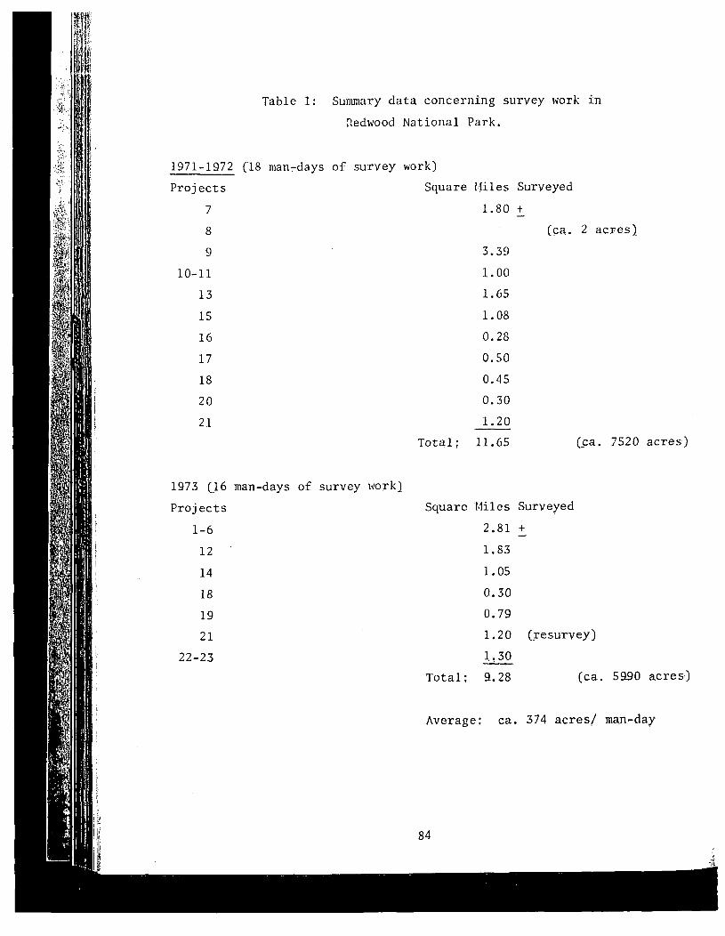
Table 1: Summary data concerning survey work in
Redwood National Park.
84
Average: ca. 374 acresl man-day
(s;a. 7520 acres)
(ca. 2 acres}
3.39
1. 00
1.65
1.08
0.28
0.50
0.45
0.30
1.20--11.65
Square Miles Surveyed
2.81 +
1.83
1.05
0.30
0.79
1. 20 (resurvey)
1~30
Total: 9.28 (ca. 5990 acres)
Total;
1973 (]6 man-days of survey work)
Projects
1-6
12
14
18
19
21
22-23
1971-1972 (18 man~days of survey work)
Projects Square Hiles Surveyed
7 1.80 t
8
9
10-11
13
15
16
17
18
20
21

",;\
<.
forests on this part of the coastline and the local vegetation is chiefly
composed of low strand plants. Because of these factors and the numerous
soil exposures in gulleys and aeolan scars, it seems probable that all of
the remaining archeological sites in this vicinity have been discovered.
Completely different circur.lstances are encountered in the Smith
River-Mill Creek vicinity (Map 2). Much of this area, particularly along
lower Mill and Clarks creeks, is heavily forested, with a dense understory
of ferns, huckleberries, hazel, etc. Beneath the duff on the forest floor
the natural soils on higher terraces are red to red-brown in color. IJear
Smith River, as much as 40-60 feet above the summer water level, the soil
is blanketed with gray to gray-white silt, which grades to sand and then
to gravel in the river channel. Exposures of silt more than 2 feet deep
were observed on habitable terraces just below Stout Grove. Aside from
the expectation that some sites may have been eradicated by flooding, the
combination of dense vegetation, duff and silt raise the possibility that
buried sites of any size could have gone undetected.
Similar forest conditions continue along Clarks Creek, except for a
large grassy meadow adjacent to Walker Road about 1/2 mile west of Clarks
Creek. This flat appears to have been used as homestead, as evidenced by
old fruit trees toward the western edge. The location would have been
ideal for an Indian camp site, but no traces of midden or aboriginal fea
tures could be found in the pale gray soil.
On the eastern side of Smith River the problems of silt and dense
vegetation are compounded by recent modifications, such as roads, houses,
stores and park developments. As on the western side of the river, it is
to be expected that some sites may have been destroyed and that others may
remain buried beneath the silt.
South of Crescent City the field situation is quite favorable between
Whaler Island and Enderts Beach. The vegetation is inconsequential from
an archeological standpoint and the terrain is quite amenable to survey
work. It is possible that drifting sand along Crescent Beach or earth
slippage between Cushing Creek and Nickel Creek could have removed or ob
scured sites. Nonetheless, it is very probable that the existing sites
in this vicinity have been discovered.
85

With few exceptions, the coastline between Enderts Beach and the
southern end of the park is characterized by steep to precipitous slopes,
with much evidence of slippage and landslides. It seems very likely that
ancient archeological sites, if they ever existed along this part of the
coast, would have sloughed off the unstable bluffs into the sea long ago.
Those sites discovered tended to be located on sheltered terraces or slopes
near the mouths of streams or on the shores of lagoons. Vegetation creates
an undeniable problem for the archeological surveyor along this part of
the coastside. There are many places where the rank stands of thimble~
berries, cow parsnip, nettles, blackberries, etc. are so dense that the
soil cannot be seen. Test holes 6" to 18" deep were dug periodically in
terraces, stream banks and other "suspicious" locations. Nevertheless,
there is a clear possibility that some coastal sites may remain unknown,
camouflaged beneath dense plant cover.
Redwood Creek (~lap 3) is another place where field conditions have
clearly affected the reliability of archeological survey data. In gener~
aI, the lower Redwood Creek Basin shows evidence of massive erosion and
flooding. Below Rocky Gap the channel tends to be broad and shallow.
Excessive accumulations of gray silt, in some palces as much as 6 feet
deep, are found on the occasional terraces and meadows near the river.
It is clear that any archeological sites which may have existed along
Redwood Creek within Redwood National Park have either been washed away
or smothered beneath a mantle of silt. Because of the danger of flooding
near this stream and the fact that dense forests extend to the very banks
of Redwood Creek, it is likely that most archeological sites will be en
countered on the lower prairies several hundred yards or more above the
water. However, the possibility of sites nearer Redwood Creek cannot be
discounted; such sites might include seasonal settlements or special pur
pose camps. This possibility must be kept in mind should any developments
be planned for the Redwood Creek drainage.
86
n/Sastaso(2)
87
VIII: Inventory of Cultural Resources
In and Near Redwood National park
This chapter describes significant archeological remains within or
adjacent to the National Park. Each site is considered in terms of its
name, nature, condition and significance.
Waterman (1925) mentioned in passing the name of this settlement
on Point Saint George. It is probable that Waterman's Sastaso"/ \~as
represented by a shellmound (now destroyed) about 1/2 mile south of the
Coast Guard Station on Point Saint George. I visited this midden in
1956, shortly before it was bulldozed into the sea to make way for a
quarrying operation. This information is largely of academic interest
now, since the midden has been eradicated.
(1) T) ay~ erte (DNo-ll)
The Point Saint George site was occupied as early as 300 BC and was
settled intensively thereafter by the ancestors of the historic Tolowa.
Known to have been used historically as a camping place for shellfish
gathering and sea lion hunting, this site was depopulated early in the
historic period by an epidemic, possibly of cholera (Gould 1966a; Drucker
1937; Waterman 1925). Today, the archeological remains at DNo-ll form the
most extensive, and possibly the oldest, midden complex on the northwest
coast of California. Archeological excavations at this site have produced
rich evidence of a maritime culture (Gould 1966a; Moratto 1960). Although
DNo-ll has been greatly disturbed by vandalism, slippage and aeolan defla
tion, the site is so large that perhaps 60% to 80% of the original deposits
remain intact. Although this site lies a few miles west of the park bound
ary, it is so important archeologically that the NPS should be aware of
its location and status. DNo-ll was nominated for inclusion on the National
Register of Historic Places in 1972.

Possibly a suburb of Ta/: tatun, Ta/ti>/ tun was situated at the norther
end of Pebble Beach (Drucker 1937; Waterman 1925). This Tolowa settlement
is represented today by DNo-13, an extensive sand, bone, shell and rock
midden. Much of the site has been disturbed by vandalism, virtually all
of which has occurred since 1959. One possible subrectangular housepit
and choppers, pestle fragments and other artifacts were observed on the
surface of DNo-13 at the time of my 1971 visit. This site undoubtedly
still has considerable archeological interest and value. However, since
it is located outside of Redwood National Park on private land, it would
appear that the NPS can do little--except in the area of public education-
to protect DNo-13 from further depredations.
(4) Meslte/ltun (DNo-17)
Located near the southern end of Pebble Beach, this wealthy offshoot
of Ta/:tatun once had nine houses and two sweathouses (Curtis 1924; Drucker
1937; Waterman 1925; Kroeber 1925). Host of the previously-extensive midde
at DNo-17 has eroded into the sea or was bulldozed during the grading for
Pebble Beach Drive. It was reported to me by local residents that numerou~
burials came to light when this site Has graded. Today, traces of shell
midden are still visible in the cliffs near the public beach access, and
there may be additional deposits beneath the parking lot. Little or nothin
of archeological significance remains at DNo-17. The site of old Y.·lesl te/11
is marked by a bronze plaque erected by the Del Norte Historical Society
at the instigation of Richard Gould.
"/(5) Sen! gxat
At the site of Seaside Hospital in Crescent City, this village was
occupied historically be people from Ta/:tatun. Sen!/gxat once had 11
houses and two sweathouses (Drucker 1937; Droeber 1925; Waterman 1925).
No archeological remnants of Sen!/gxat could be discovered, but it is
possible that some cultural deposits have survived beneath the hospital
and its landscaping.
(6) DNo-18
88

89
(8) DNo-Sl (Possible Indian Grave)
During the summer of 1969, Ritter reported that the grave of a "Chief
Phillips" (Tolowa?) was located near a large rock outcrop on the south edge
of Smith River, downstream from the Hiouchi Bridge. The site is located
within a mixed forest of redwood, fir, hemlock and madrone, and its surface
(7) Si) tragI)/tum
Drucker (1937) describes this as an "old site" with one house and one
sweathouse, inhabited by a man from E/:tculet. This settlement was appar
ently situated on a terrace on the west bank of Smith River, north of the
Hiouchi Bridge. The locality has been logged and flooded in the past and
is presently covered with dense forest. No trace of Indian habitation
could be discovered here during King's (1972) examination or during my
survey in 1973. What is apparently the same location was visited by E.
Ritter in 1969. Ritter did not inspect the site closely, but he recorded
the fact that two local residents had collected broken projectile points
there. The presumed archeological site was designated "DNo-S4" by Ritter
(cf. files of the State Department of Parks and Recreation, Cultural
Resources Section).
Regarding this site, which apparently is (or was) located near the
northeastern periphery of Jedediah Smith Redwoods State Park, we have the
following information:
According to the files of the University of California (Berkeley)Archaeological Research Facility, an aboriginal site known as4-DNo-18 is located in the (vicinity) ... We found no evidenceof such a site, however, and Mr. Peacock, who owns the property,assured us that no such site existed. Instead, he informed us,there was a site which he had showed to an archaeologist in thepast, '" This site included a cemetery and a s\veathouse depression, but was covered by the construction of Route 197 afew years ago. At the prescribed location we found a broadlower terrace, moderately alluviated, and a narrow upper terrace almost completely covered by the Route 197 roadbed. Asidefrom a few possible fire-cracked rocks on the ,remnant terraceprotruding from beneath the road fill, no clear evidence of anarchaeological site was noted. We surmise, however, that thisis the most likely real location for DNo-18. (King 1972: 11)
<,,
is covered with river alluvium. Information regarding this putative site
was provided to Ritter by C. O. Young, a local resident. No cultural
manifestations were observed at DNo-Sl (cf. files of the State Department
of Parks and Recreation, Cultural Resources Section).
(9) Tcunsu/ltun
This ethnographic Tolowa village on the north bank of Smith River
reportedly had two houses and a sweathouse and was a suburb of Ta/:
tatun at Crescent City (Drucker 1937). A very extensive archeological
site discovered during the 1973 survey presumably represents the old
village of Tcunsu/ltun. This site is located within Jedediah Smith
Redwoods State Park. Rich, black midden is present. Four chipped stone
fishnet sinkers, two 19th century bottle glass fragments and numerous
pieces of worked chert and obsidian were found on the surface. This may
be the site designated DNo-S2 by Ritter in 1969, but Ritter's verbal de
scription is inconsistent with his map coordinates. Ritter notes that a
Mr. Sawyer had collected about 20 projectile points, retouched flakes,
ocean shell scrapers, hammerstones and core tools from the surface of
DNo-S2 (cf. files of State Department of Parks and Recreation, Cultural
Resources Section).
T. F. King, in the course of his 1972 survey for the State Division
of Highways, also reported a site which he considered to be Tcunsu/ltun:
This village had two houses and a sweathouse, and was a suburbof Tatatun, a large village near Crescent City. This propertyhas recently been purchased by the National Park Service •••(King 1972: 11)
It seems clear that the north bank of Smith River in this area was
extensively utilized by the Indians. Although it is probable that the,
site described by King is merely the periphery of the midden discussed
above, the ascription of the name Tcunsu/ltun to either site (or to Doth
of them collectively) would seem reasonable. It may be, in fact, that the
"two" sites merely reflect settlements by the same community at different
times. In any event, the archeological remains would appear to be of
exceptional scientific value. The apparent site of Tcunsu/ltun seems to
90

~ -:
be the only midden site within Jedediah Smith Redwoods State Park. Fur
thermore, this is the only reasonably intact inland archeological site
known to exist within the proposed boundaries of Redwood National Park.
(10) DNo-S3
This midden site, located north of Smith River and northeast of the
park boundary, was first recorded in 1969 by Ritter, who discovered scat
tered lithic flakes on the surface. The site is so badly disturbed by
erosion, gardening, a residence and a roadcut that it would seem to be of
little archeological value (cf. files of the State Department of Parks and
Recreation, Cultural Resources Section).
(11) DNo-S5
Based on information received from C. Sa\~er of Crescent City, Ritter
recorded DNo-S5 as a "rock outcrop and midden deposit with bedrock mortars"
on the western edge of Mill Creek. According to the report given to Ritter,
a stone pestle and two bowl mortars were collected from this site (cf. files
of the State Department of Parks and Recreation, Cultural Resources Section).
nle site could not be found during the 1973 reconnaissance. It is possible
that forest litter obscures the site or that the location given to Ritter
was inaccurate.
(12) Te/:nItcuntun
Since the recorded location of Te/:nItcuntun falls nearly a mile
northeast of the park, no attempt was made to search for the site in 1973.
However, a survey of the area was made in 1972:
We assiduously searched the area ••. without finding any evidenceof aboriginal occupation. The margins of the ridge ••• haveclearly been subjected to extreme erosion, however, and placeroperations are reported in the vicinity.•• At this location tooare several massive cobble walls ••• and an apparent old dumpwell excavated by bottle hunters •••• It is quite possiblethat these various modifications have removed all traces ofTe/:nItcuntun ••• (King 1972: 12)
(13) Ta/:tatun (DNo-16)
91

This was the main Tolowa village in Crescent City, located on Battery
Point. In historic times this village was raoved to Scn~/gxat (Drucker
1937; Waterman 1925). All archeological evidences of Ta/:tatun appear to
have been obliterated by rock quarrying.
v (
(14) Sxme (DNo-ls)This was a 19th century Tolowa hamlet on the north side of Cushing
Creek. It is said to have had one house and a sweathouse (Moratto 1972).
A reasonably intact, but apparently shallow, shell midden occupies the
place of old SxmJ. This midden is the most northerly coastal archeolog
ical site within the National Park. At present, the site seems endangered
only by gradual erosion.
(15) TSiniYa~ (DNo-14)Located on both sides of Nickel Creek, Tsiniyat~ was a late pre-
historic-early historic Tolowa village of at least two houses and a sweat
house. This site may have been utilized most intensively during the summer
fishing season. It was abandoned around 1880 (Moratto 1972; Waterman 1925;
Kroeber 1925). A moderately disturbed archeological site remains.
(16) DNo-S7Ritter first discovered this archeological site in 1969 during his
survey of Del Norte Redwoods State Park (cf. files of the State Department
of Parks and Recreation, Cultural Resources Section). Located on a small
terrace along Damnation Creek, DNo-S7 consists of a shell midden ca. 50
meters in diameter and 1 meter deep. Flakes of chert were found on the
surface. This site is essentially intact and does not appear to be in
danger of disturbance.
(17) DNo-S8DNa-58, located at the base of a rocky cliff, is of unusual interest
because it is the only rockshelter site known within Redwood Hational
Park. A small, shallow shell midden extends about 8 or 9 meters down the
slope from the mouth of the cave. If this site dates to the protohistoric
92

or early historic period, it is probably the most southerly Tolowa settle
ment \vithin the National Park. a/menhipu/r, a village a little further
south, was known to have been settled by the Yurok.
(18) a/menhipu/r (DNo-2 and DNo-7; also, DNo-S9)
This village of seven or eight houses, located on both sides of
Wilson Creek, was the most northerly Yurok settlement (Waterman 1920).
Recent highway construction has virtually obliterated the archeological
remains of a/menhipu/r. Highly disturbed lenses of shell midden are pres
ent, as are scattered bits of shell. The University of California (Berke
ley) Archaeological Survey has assigned separate numbers (DNo-2 and DNo-7)
to the middens north and south (respectively) of Wilson Creek. In 1948,
when A. P. Miller of U.C. surveyed the site, there were still extensive
midden deposits and at least three house pits visible. Three cairns of
stones, possibly grave sites, were also recorded in 1948 at a point about
500 yards north of DNo-2. Unless some relatively undisturbed deposits are
concealed, this site would appear to be of little worth to archeology.
(19) a/men (DNo-l; also, DNo-SlO)
Situated on the coast, the village of a/men contained at least four
houses and a sweathouse (Waterman 1920). Disturbed remnants of a once
extensive archeological deposit are to be found and the remaining shell
midden has been considerably damaged. The four house pits still visible
in 1948 (at the time of the U.C., Berkeley, survey) have been obliterated.
Nevertheless, a sufficient portion of the midden remains to warrant mean
ingfUl archeological sampling in the future.
(20) Re/kwoi (DNo-5)
With 22 to 25 houses, Re/kwoi was not only the largest Yurok village
on the coast, but ,also one of the best preserved. An extensive midden,
one reconstructed family house and several house pits remain today. The
dark, sandy midden contains numerous shells, fire-fractured rocks, chert
flakes and sea mammal bones. Presumably, the site would also contain a
great quantity of salmon bones, but these were not observed on the surface.
93

Al though Re/kwoi falls a fe\~ hundred yards east of the Redwood National
Park boundary, its preservation and interpretation should be a matter of
concern for the !~ational Park Service. In 1971, Re/kwoi was nominated
for inclusion on the National Register of Historic Places.
(21) We/lkwaw (DNo-6)
Nine houses are reported to have stood in this town. We/lkwaw was
one of a half-dozen Yurok villages with a sacred sweathouse where a White
Deerskin or Jumping dance could be performed (Kroeber 1925; Waterman 1920).
A few native house frames were still standing in 1920, but barns and out
buildings occupied much of the former Yurok site (Waterman 1920). No
trace of aboriginal settlement could be discovered during our survey.
Much of the locality has been bulldozed to bedrock, the remainder being
covered with vestiges of sawmill and ranch structures. TIlis former site
falls within park borders, but nothing of archeological value remains.
(22) Tse/kwel
According to Waterman (1920), this village was located on the south
bank of the Klamath River. The area is now overgrown by alder brush and
no evidence of native habitation could be discovered.
(23) O/segen (Hum-136)
This was a small coastal Yurok hamlet of three houses and two sweat
houses (Waterman 1920). Two sweathouses were still standing in 1935 (Hood
1965). Much of the site has been disturbed by historic activities and
only scattered traces of shallow midden could be discovered.
(24) E/spaw (Hum-133)
E/spa.w was an important Yurok coastal town of four to seVen houses.
This settlement was occupied until early in the 20th century and had accu
mulations of shell "several yards thick" (Curtis 1924; Waterman 1920;
Kroeber 1925). Surveys by Ritter in 1969 and by me in 1971 failed to pro
duce any traces of the former midden. The area has been modified consid
erably by roads, logging, mining, Coast Guard activities, recreation use
94

and modern residences. A dense, young forest of conifers and alders also
covers a portion of the area. It would appear that all traces of the old
village of E/spaw have vanished during the last half century.
(25) Major Creek Settlement
The 1973 reconnaissance disclosed the presence of a historic coastal
site. Although there is no appreciable midden buildup in this location,
there are bits of glass, porcelain and pieces of iron scattered over the
surface. None of the artifacts appears to be more than 50 or 60 years
old. It is surmised that a house or cabin once stood here, probably dur
ing the early 20th century.
(26) O-tmekwo/r (Hum-135)
Waterman (1920) described this as an old site with five house pits
near Redwood Lagoon. Waterman further postulated that O-tmekwo/r might
be the site from which the inhabitants of Ore/qWoriginated. Bearss (1969:
14) states, in apparent conflict with waterman's statements, that the site
was occupied in 1912. This site, designated Hum-135, was visited and
recorded in detail as part of the 1973 reconnaissance program. It was
discovered that a virtually undisturbed, deep midden--comprised of shell,
mammal bone, fire-fractured rocks, etc.--covers an area measuring ca. 40 x
75 meters. An elk antler wedge, several pestles, stone fishnet sinkers
and numerous chert cores and flakes were observed on the surface of the
midden. Hum-135 is of particular importance because it has not been dis
turbed by vandals and because it is the only reasonably intact archeolog
ical site of its kind within the park. Since many crucial questions re
garding lagoon-related adaptive strategies might ultimately be answered
through the scientific investigation of this site, it is imperative that
the midden be safeguarded as one of Redwood National Park's most valuable
cultural resources.
(27) Ore/qW (Hum-131)
Also in the vicinity of Redwood Lagoon was Ore/qW, a Yurok settlement
of six houses, a sweathouse and a cemetery. This was one of the villages
95

96
Waterman (1920 describes sI/gwets as an old to\ffi site, a suburb of
Ore/qw. The site was destroyed by the construction of Highway 101 and a
parking area.
(31) Hum-S3
No Yurok name is knO\ffi for this archeological site, which was first
recorded by Ritter in 1969 (cf. files of the State Department of Parks and
Recreation, Cultural Resources Section), Apparently used as a hunting
camp, the site consists of a scatter of chert flakes and point fragments
-/Si gwets (Hum 132)
where the Jumping Dance was held. The early population of this settlement
is estimated to have been 25 to 35 persons (Waternan 1920). The 1961 re
routing of U.S. Highway 101 greatly damaged the site and exposed 23 burials.
No trace of midden could be found in the vicinity of Ore/qW ouring two
visits in 1971. However, the place is overgrown with alder, thimbleberries ,cow parsnip, etc., and it is possible that some portion of the original
midden has escaped both damage and detection. Ore/qW was important et}mo
graphically as the principal Yurok village in the neighborhood of Redwood
Lagoon. Modern Orick is named after this site.
(28)
(30) Ori:i/w
This was a Yurok camp site with a collection of shelters used during
acorn harvests (Waterman 1920). It was located on the bank of Prairie
Creek. Any midden which may have existed has been destroyed or buried
beneath Highway 101.
(29) Hr/gwr)W (Hum-130)
More than a century ago, Hr/gwr)W was a Yurok village of seven houses
and two sweathouses near Stone Lagoon. In 1863 Chilula Indians from Bald
Hills raided this village and killed 10 people; the survivors settled at
Tsa/hpekw (Waterman 1920; Kroeber 1925), The archeological remains of
I-Ir/gwr)W were destroyed by highway construction during the early 1960s.
The midden was recorded in 1948 by University of California archeologists.

on Elk Prairie. The site shows no appreciable depth of deposit or midden
buildup.
:' (32) Hum-180
This archeological site in Prairie Creek Redwoods State Park was
discovered by University of California archeologists in 1948. It is com
prised of shell fragments, chert flakes and other artifacts scattered over
the surface. It is probable that Hum-180, Hum-53 and other as yet undis
covered sites were used as temporary hunting camps by small bands of Yurok
from more permanent coastal villages.
(33) Split Rock ("Nock Haye")
This cleft monolith was of mythological significance to the Yurok
(see Ch. III). The native explanation of Split Rock is given on a road
side plaque set up by the National Park Service.
(34) Tsa/hpekW (Hum-129)
This was a village of 11 houses near Stone Lagoon (Waterman 1920;
Moratto 1970, 1972). Hum-129 is a very large and deep, but badly van
dalized, midden, which has produced abundant evidence of protohistoric
historic Yurok culture (see Ch. VI; l.1oratto 1972). This site is deserving
of special protection, not only because of its value as an archeological
resource, but also because it contains an Indian cemetery with the remains
of persons related to Yuroks still living along the northwest coast.
Tsa/hpekw is still a place of considerable religious value for the local
Indians.
(35) Stone Lagoon Fishing Camp
In 1970 D. Wood and I located what was presumably a Yurok fishing
place. This site consisted of nearly 100 stone fishnet sinkers and chop
pers scattered along a laO-meter stretch of rocky shoreline. A hopper
mortar base was discovered, but no midden or other vestiges of settlement
could be found. It is surmised that this site was used as a fishing place
by Indians living at one of the nearby villages (cf. ~bp XI),
97

(36) Tso/tskwi (Hum-121)
This old village site near Dry Lagoon may have had as many as 12
houses and two sweathouses (Waterman 1920). Today, a large midden with
considerable evidence of vandalism remains. The midden consists of dark
ened soil with fire-cracked rocks, chert flakes, shell frawnents, chipped
pebble sinkers and miscellaneous artifacts. The activities of pot hunters
have resulted in the destruction of some 30% or more of the midden.
(37) Nolediii
Goddard (1914b) has provided considerable information concerning
this Chilula settlement along Redwood Creek (see Ch. III). The site
was visited in 1973 and positively identified on the basis of the hollow
redwood trees within which "families used to spend the winter" (Goddard
1914b: 273). N61edifi today consists of two, or possibly three, house
pits and two fireplaces made of fieldstone set in mud mortar. No midden
or aboriginal artifacts were discovered. It is ~resumed that N61edifi
was occupied by acculturated Chilula during the historic period. The
fireplaces and contiguous house pits clearly represent small cabins of
non-aboriginal design,. Given the fact that the Chilula of the 1860s built
a log cabin-style fort, it is not at all unreasonable that cabins of the
American type would have been constructed by the Indians at N61ed:iii.
(39) X6wUnnakut
Goddard (1914b) reported this settlement to have been the first
Chilula village on Redwood Creek. If Goddard's (l914b) location for
N61ediii is correct, then it almost certainly is well outside of Redwood
National Park.
98

IX: Conclusions and Recorunendations
This report has summarized the status of anthropological knowledge
about the area of Redwood National Park. An attempt has be.cn made to
describe the ric~less of prehistoric and etlmographic cultures of the
north coast region and to review prcvious anthropological rcsearch in the
area. It is hoped that the archeological remains described in this paper
will be evaluated against this background and be managed accordingly.
A number of recommendations may be offered with respect to the anthro
pology of the Redwood National Park region:
(1) Although approximately 21 square miles of land within and adja
cent to the park have been examined for archeological remains, additional
surveys may become necessary as future development plans are approved.
(2) Among the objectives for the park are the protection of resources
and the explanation of their significance (i-JPS 1971: 6-7). These goals
apply to cultural, as well as natural, resources. Suggestions for the
protection of specific archeological sites lmve been given in the pre
ceding chapters. However, little has been said regarding archeological
interpretive programs.
The resources of the park contain great interpretive potential.
An obvious proposal would be the reconstruction of a native village-
complete with family houses, a sweathouse, perhaps a canoe and other
artifacts--at one of the scenic archeological sites within the park.
TsiniyatYa, Tcunsu/ltun or a/men would be ideal locations for village
reconstructions. It would also be desirable to install major "conven
tional" exhibits regarding local Indian cultures at the planned inter
pretive centers. Other suggestions for educational endeavors include
establishment of explanatory plaques at landmarks important to the Indians
(as has been done at Split Rock) and the preparation of a booklet (for
sale at Visitor Centers) dealing with the Indians of the park area.
(3) The Park Service should explicitly and programmatically recog
nize that viable Indian cultures are still very much a part of the north
coast area. This recognition carries with it both obligations and oppor
tunities. If possible, the Park Service should take advantage of the fact
99

that much useful ethnography may still be done among elderly Indian people.
A conscientious effort to record Yurok, Tolowa and Chilula "r.1cJilory cultures"
would undoubtedly produce new data concerning man's relationship with the
redwood region as it was a century ago. In a few more years much of this
information will have vanished. At the same time, it may be possible to
cooperate with the local Indian people in the establishment of a program-
possibly to include native dances or craft displays--for the edification
of park visitors. In this regard it cannot be stressed too strongly that
any such program must be developed hand-in-hand with the Indian partici
pants. It cannot be designed solely to meet the needs of the National
Park Service or be imposed upon the Indians as a fait accompli.
(4) Three archeological sites were nominated in April, 1972, for
inclusion on the National Register of Historic Places. Two of these,
DNo-ll and DNo-S, are just outside of the park. It is suggested, there
fore, that Redwood National Park personnel be instructed to visit these
sites periodically and to report any apparent violation of the federal
statutes governing such historic places. The third site is the Jedediah
Smith campsite at Cushing Creek. The Cushing Creek location was the site
of the historic Tolowa Village (or camp) called SxmJ. Since Jed Smith
referred to his camp site as "Nec-kah," a name which I have previously
shown to have been associated with Nickel Creek rather than Cushing Creek
(Moratto 1972), it may be that Smith pitched camp at T~iniYatY,;) instead of
Sxme? This entire business should be studied thoroughly by a cOlilpetent
historical geographer. When the historic campsite has been established
with certainty, appropriate interpretive devices should be set up at the
site. It would also be useful to have signs or plaques at the other sites
on the National.Register.
(5) Recognizing the fact that the National Park Service does exert
some influence beyond the actual confines of Redwood Hational Park, it is
recommended that steps be taken toward the preservation of whatever arche
ological sites might exist in the "Cooperative Management Zone" outside
the park. For example, logging companies and other private landowners in
the Cooperative Management Zone ought to be formally notified that the
California Environmental Quality Act (and subsequent court interpretations
100

101
Pt. St. George Phase: As early as several centuries BC;
known only from the lower levels
of Point Saint George (PNo_ll)
(see Chapter V).
It is also possible that evidence of substantially earlier cultural
activity may be discovered in northwest California. In any event, a great
deal of work needs to be done in order to clarify the nature, cultural
Historic period; characteristic
assemblages have been excavated
at Tsurai, Tsahpek w and southern
DNo-11 (see Ch. V for diagnostic
artifacts}.
Late prehistoric period, back to
AD 900 or earlier; as represented
at Gunther Island, Patricks Point,
T§iniYat'a and Point Satnt George
II (see Ch. V).
Gunther Is. Phase:
thereof) require archeological assessments prior to significant modifica
tions of the landscape. Thus, logging operations in the Cooperative Man
agement Zone should be preceded by environmental impact studies which
include archeological impact evaluations.
(6) Ultimately, the Park Service should develop an archeological
management and research strategy in consultation with local Indian leaders
and professional archeologists. No excavations in the archeological sites
of the park should ever be permitted unless the site is unavoidably jeop
ardized by developments or significant anthropological research questions
are to be answered.
In light of the great damage suffered by archeological remains through
out northern California, the extant sites in Redwood National Park have
significant value and potential for contributing to the unders-tanding of
regional prehistory. Chapter V has suggested that three, or possibly
four, vaguely known cultural phases exist in the sequence of hu~an occu
pation in northwest California. These might be tentatively na,med and
represented as follows:
Trinidad Phase:

affiliation and dating of the phases proposed above. Any future archeo
logical studies should consider these phases in terms of possible ties
with archeological phenomena in southern Oregon, northeastern California
and the Coast Ranges to the south (cf. Fredr ickson 1973).
We are left with an uncomfortably large number of anthropological
questions: When did man first arrive in the redwood region? What were
the approximate times at which the ancestors of the Karok, Tolowa-Hupa
Chilula and Yurok-Wiyot appeared in the area? HO\~ and why did adaptive
strategies and demographic patterns change throughout the prehistoric
sequence on the north coast? What sorts of forces shaped diverse peoples
and cultures into the distinctive Northwest California Culture Area of the
ethnographic horizon? How did the evolving social, economic and political
patterns interact and how did these, in turn, relate to subsistence efforts
and food surplus; that is, is it possible to archeologically trace the
development and origins of the complex socio-economic network described by
Gould (1966b)? How did coastal lifeways differ from those of the interior
when practiced by the same society?
Many other similar questions could be formulated, even with the lim
ited information available at present. The extent to which answers may be
provided will depend to a great extent upon the thoroughness and sophisti
cation of the archeological management and research program designed for
Redwood National Park. Such a far-reaching program cannot be devised until
park development proposals are clarified and until the Indian people are
willing to permit significant excavations. Meanwhile, the complete preser
vation of every archeological site known in the park constitutes the only
justifiable course of action.
102

103
Bibliography
Bancroft, H. H.1883 The native races of the Pacific states. San Fr~ncisco.
University of California Publications
History of California: 1860-1890. In The works ofHubert Howe Bancroft, Vol. 24. The History Co., S~n
Francisco.
1885
1890
The Karok language.in Linguistics 13.
Buchanan, R. C.1857 Number, characteristics, etc., of the Indians of California,
Bright, W.1957
J.History of Del Norte County, California. Wendy's Books,Crescent City.
Indian wars of the Northwest: A California sketch.Biobooks, Oakland.
Bloomfield, L.1946 Algonquian. In Linguistic structures of Native America.
Viking Fund Publications in Anthropology, No.6: 85-129.
Bledsoe, A.1881
Baumhoff,1963
M. A.Ecological determinants of aboriginal California populations. University of C~lifornia Publications in AmericanArchaeology and Ethnology 49: 155-235.
L. and J. A. HesterA new ecological typology of the California Indians.Acts of the International Congress of Anthropologicaland Ethnological Sciences 5: 411-419.
Bearss, E. C.1969 History basic data, Redwood National Park. U.S. National
Park Service, Washington.
Beals, R.1960
Becking, R, W,1973 Letter to director, Cultural Resources, of Parks and
Recreation, Sacramento. Dated June 20, 1973.
Bennyhoff, J. A.1950 California fish spears and harpoons. University of
California Anthropological Records 9 (4),
Berreman, J, V.1937 Tribal distributions in Oregon. American Anthropological
Association Memoir, No. 47.
1944 Chetco archaeology. General Studies in Archaeology, No.11.

104
They pushed back the forest. Del Norte County HistoricalSociety, Crescent City.
The epidemic of 1830-1833 in California and Oregon.University of California Publications in AmericanArchaeology and Ethnology 43: 303-326.
The aboriginal population of the north coast of California.University of California Anthropological Records 16:81-130.
Archaeological survey of the Buzzards Roost Dam Reservoir.Unpublished manuscript. On file at Natural History r.1useum,University of Oregon, Eugene.
Report on investigations of archaeological sites in thereservoir areas of: Sucker Creek Dam, Applegate Dam,Lost Creek Dam, and Collier State Park. Unpublishedmanuscript. On file at Natural History Museum, University of Oregon, Eugene.
J. L. and K. K. ChartkoffTest excavations at the Hay site, Seiad Valley, SiskiyouCounty, California. Unpublished manuscript. On file atMichigan State University, East Lansing.
Buckley, J,1970
1965b
1956
California1955
Oregon, and Washington. H. R. Ex. Documents, No. 76(Serial No. 906), 34th Congress, 3rd Session.
and E. WillisPoint Saint George I, California. Radiocarbon 12 (1).
State SenateProgress report to the legislature by the Senate InterimCommittee on California Indian Affairs. Senate Resolution, No. 115.
Caughey, J. W.1961 California. Prentice-Hall, Englewood Cliffs.
Chartkoff,1973
Cole, D. L.1965a
Cook, S. F.1955
Chase, D.1959
The Humboldt Bay region, 1850-1875. California StateHistorical Association, Los Angeles.
Cressman, L. S.1933a Aboriginal burials in southwestern Oregon. haerican
Anthropologist 35.
1933b Contributions to the archaeology of Oregon: Final reporton the Gold lIill Burial site. University of OregonStudies in Anthropology 1 (1).
1951 Western prehistory in the light of carbon-14 dating.Southwestern Journal of Anthropology 7 (3): 289-314.
Coy, O. C.1929

105
Curtis, E. S.1924 The North American Indian (Vol. 13), Published by E, S.
Curtis and E. p. Morgan, Norwood.
Barbed projectile point: A description andSan Francisco State University.
The Tolowa and their southwest Oregon kin. Universityof California Publications in American Archaeology andEthnology 36: 221-300.
Culture element distributions: XXVI, Northwest Coast.University of California Anthropological Records 9 (3).
Cultures of the north Pacific coast. Chandler PublishingCo., San Francisco.
Archaeology of the Lost Creek Dam Reservoir. Unpublishedmanuscript. On file at Department of Anthropology, OregonState University, Corvalis.
E.Culture element distributions: X, Northwest California.University of California Anthropological Records 1;297-433.
B.The Chimariko Indians and language. University of California Publications in American Archaeology and EthnologyS: 293-380.
and A. L. KroeberNew linguistic families in California. American Anthropologist 13: 647-655.
Linguistic families in California. University of CaliforniaPublications in American Archaeology and Etlmology 16:47-118.
D.The Guntherevaluation.Dittoed.
1950
1965
1919
Elsasser,1965
Dixon, R.1910
The wealth concept as an integrative factor in Tolo\'laTututni culture. In Essays in Anthropology Presentedto A. L. Kroeber, edited by R. H. Lowie. Universityof California Press, Berkeley.
A. B.The archaeology of the north coast of California.Unpublished Ph.D. dissertation. Department of ~ltlITo
pology, University of California, Berkeley.
Elsasser, A. B. and R. F. Heizer1966 Excavation of two northwestern California coastal sites.
Dubois, C.1936
Davis, W.1968
Dotta, J.1967
Dixon, R.1913
Driver, H.1939
Drucker, P.1937

106
Californian shell artifacts. University of CaliforniaAnthropological Records 9 (1).
E.Life and culture of the Hupa. University of CaliforniaPublications in American Archaeology and Ethnology 1:1-88.
Unpublished field notes (11 vol.) collected at SmithRiver, California, 1902-1903. On file with the AmericanPhilosophical Society, Philadelphia.
Hupa texts. University of California Publications inAmerican Archaeology and Etlmology 1; 89-368.
Athabascan. In Handbook of American Indian languages.Bureau of American Ethnology Bulletin 40 (1): 85-158.
Wayside shrines in northwestern California. AmericanAnthropologist 15: 702-703.
Chilula texts. University of California Publications inAmerican Archaeology and Ethnology 10: 289-379.
Notes on the Chilula Indians of northwestern California.University of California Publications in American Archaeology and Ethnology 10: 265-288.
Journal of the expedition of Col. Redick M' Kee •.. throughNorthwestern California ... in 1851. In Indian Tribes 3:99-177.
19l4a
19l4b
1913
1973
1904
1947
1903b
1911
Evermann,1931
University of California Archaeological Survey Reports,No. 67, Part 1.
B. W. and H, W, ClarkA distributional list of freshwater fishes knO\ffl to occurin California. Bulletin of the California Fish and GaneCommission 35.
Fredrickson, D. A.1973 Early cultures of the North Coast Ranges. Unpublished
Ph.D. dissertation. Department of Anthropology, University of California, Davis.
Fry, W. S.1904 Humboldt Indians. Out West 21: 503-514.
Gibbs, G.1853
Goddard, P.1903a
Observations on the Indians of the Klamath River andHumboldt Bay, accompanying vocabularies of the Languages,edited by R. Heizer. University of California Archaeological Research Facility, Berkeley.
Gifford, E. W.1940 Californian bone artifacts. University of California
Anthropological Records 13 (2).

Goddard, P.E.1924 Indians of the northwest coast. American Huseum of Natural
History Publications, No. 10.
107
The Indians of California: A syllabus (with additionalmimeographed course outline). University of CaliforniaPress, Berkeley.
The western coast of North America. In Prehistoric Manin the New World, edited by J. Jennings and E. Norbeck.Aldine, Chicago.
George Gibb's journal of Redick McKee's expedition throughnorthwestern California in 1851. University of CaliforniaArchaeological Research Facility, Berkeley.
Field notes from Patricks Point. University of CaliforniaArchaeological Survey Manuscripts, Berkeley.
The archaeology of northwestern California. Universityof California Archaeological Survey 14anuscripts, Berkeley.
Algonkian-Ritwan: The end of a controversy. InternationalJournal of American Linguistics 24: 159-173.
F.Curved single-piece fishhooks of shell and bone in California. American Antiquity 15:89-97.
A prehistoric Yurok ceremonial site (Hum-174). Universityof California Archaeological Survey Reports, 11:1-4.
n.d.b
n.d.a
1964
1972
1951a
1951b
Haas, N.1958
A.Aboriginal California burial and cremation practices.University of California Archaeological Survey Reports,No. 60: 149-168.
1966a Archaeology of the Point Saint George site and Tolowaprehistory. University of California Publications inAnthropology 4.
1972 A radiocarbon date from the Point Saint George site,northwestern California. Contributions of the Universityof California Archaeological Research Facility, 14:41-44.
Graves, Co S.1929 Lore and legends of the Klamath River Indians. Yreka
(California) Times Press.
Gudschinsky, S.1964 The ABCs of lexicostatistics (glottochronology). In
Language in culture and society, edited by D. Hymes.Harper and Row, New York.
Gould, R.1963
Heizer, R.1949

108
Hoijer, H.1956 The chronology of the Athabascan languages. International
relations of aboriginal fishingCalifornia Fish and Game 28 l2):
The Pistol River site of southwest Oregon. University ofCalifornia Archaeological Survey Reports, No. 67, Part 2.
Notes on environment, prehistory, and ethnography ofsouthwest Oregon. Unpublished manuscript. On file atDepartment of Anthropology, University of Oregon, Eugene,
O.Archaeological survey of the pipeline distribution system,Applegate Division of Rogue River Basin Project, Bureauof Reclamation. Unpublished manuscript. On file atNatural History Museum, University of Oregon, Eugene.
The California Indians:and enlarged edition).Berkeley.
F. and A. B. ElsasserThe four ages of Tsurai: A documentary history of theIndian village on Trinidad Bay. University of CaliforniaPress, Berkeley.
Archaeology of Hum-67, the Gunther Island site in HumboldtBay, California. University of California ArchaeologicalSurvey Reports, No. 62: 1-122.
The archaeology of northwestern California. University ofCalifornia Archaeological Survey Manuscripts, Berkeley.
F. and A. E. TreganzaMines and quarries of the Indians of California. CaliforniaJournal of Mines and Geology 40 (p): 291-359.
F. and M. A. Whipple (Eds.)The California Indians: A source book. University ofCalifornia Press, Berkeley.
W.Economic and geographicin northern California.103-110.
1947 Aboriginal use of fishing resources in northwestern NorthAmerica. Unpublished Ph.D. dissertation. University ofCalifornia, Berkeley.
Heizer, R.1952
n.d.
1971
1964
Heizer, R.1944
Heizer, R.1951
Helfin, E.1966
Henrickson,1967
Henn, W. G.1972
Hewes, G.1942
Hi t tell, T. H.1885 History of California. San Francisco.
Hodge, F. W.1910 Handbook of American Indians north of Mexico. Bureau
of American Ethnology, Bulletin 30.

Hostler, P.1967 History of the Hoopa tribe. Hoopa Valley Tribe.
American Anti-Great Basin prehistory and Uto-Aztecan.quity 31 (1): 48-60.
109
Letter to O. Jones regarding archaeological sites onCalifornia's northwest coast. On file with the StateDepartment of Parks and Recreation, Sacramento.
Journal of American Linguistics 22: 219-232,
Culture element distributions: The structure of CaliforniaIndian culture. University of California Publications inAmerican Archaeology and Ethnology 37: 12-70.
L.Basket designs of the Indians of northwestern California.University of California Publications in American Archaeology and Ethnology 2: 104-164.
Wiyot folklore. Journal of American Folklore 21: 37-39.
The languages of the coast of California north of San
An assessment of the potential impact of proposed improvements to U.S. Highway 199 on historic and prehistoricresources. California Division of Highways, Eureka andSacramento.
Interaction and innovation: A research design for archeology in the North Coast Ranges. Manuscript in preparation.
S.Ripples on a gene pool: The shifting frequencies of theblood-type alleles among the Indians of the Hupa Reservation. American Journal of Physical Anthropology 18 cn:141-152.
H.A note on Athabascan glottochronology. InternationalJournal of American Linguistics 23: 291-297,
n.d.
1908
1911
Klimek, S.1935
Kroeber, A.1905
King, T. F.1972
Hood, J. D.1965
Hopkins, N.1965
Hulse, F.1960
Hymes, D.1957
Jackson, T.1972
L.X-ray fluorescence analysis of obsidian from 4-DNo-14.In Archeological investigations in the Redwood NationalPark region, California, by M. J. Moratto. NationalPark Service, Tucson.
Johnson, L., Jr.1969 Obsidian hydration rate for the Klamath Basin of California
and Oregon. Science 165: 1354-1355.

Smithsonian
110
H.Unpublished Tolowa field notes and vocabulary, collectedat Smith River and Crescent City, California, 1910-1938.Universi ty of California Archaeological Research Facil i ty,Berkeley. Hanuscript.
Francisco. University of California Publications inAmerican Archaeology and Ethnology 9; 273-435.
Handbook of the Indians of California. Bureau of AmericanEthnology, Bulletin 78.
Preface to The structure of California Indian culture,by S. Klimek. University of California Publications inAmerican Archaeology and Ethnology 37: 1-11.
Cultural and natural areas of native North America.University of California Publications in American Archaeology and Ethnology 38.
L. and S. A. BarrettFishing among the Indians of northwestern California.University of California Anthropological Records, 21 (1).
L. and E. W. GiffordWorld renewal, a cult system of native northwest California.University of California Anthropological Records 13: 1-156.
and R. F. HeizerAlmost ancestors. Sierra Club - Ballentine Books, SanFrancisco.
The Yurok of Trinidad Bay. In The California Indians:
Ethnography and archaeology of the lViyot territory.University of California Publications in American Archaeology and Ethnology 14 (3): 221-437.
J.Remarks on shellmounds near Camp Hendocino, HwnboldtCounty. In Prehistoric fishing, by C. Ran. SmithsonianInstitution, Washington.
1904
1925
1939
1935
Kroeber, A.1949
Kroeber, A.1960
Kroeber, T.1968
Loud, L. L.1918
Meyer, C.1951
T.The Ray Collection from Hupa Reservation.Institution Annual Report, Year 1886.
Aborigina1 American basket ry • .::S:::.m:.:i:.,:t:.:.;h:.:s:.,:o:.:.;n:.:i:.:a:;.n::.........:I:;.n:..:s:..;t:..;i:.:t:..;u:.:t:.:i:.:o:.:.:,nAnnual Report, Year 1902.
Meredith, H. C.1900 Archaeology of California: Central and northern California.
In Prehistoric implements, by W. K. Moorehead. Cincinnati.
Mason, O.1889
Merriam, C.19101938
MacLean, J.1884

111
Palais, B.1958 History. In Natural resources of northwestern California.
UnpublishedCalifornia
Archaeology and cross-cultural ethics in coastal northwestCalifornia. R.E. Schenk Archives of California Archaeology,Ho. 28
R. and R. E. SchenkAn archaeological survey of the proposed Butler ValleyReservoir, Humboldt County, California. Department ofAnthropology, San Francisco State University.Manuscript.
H.Yurok-Karok basket weavers. University of CaliforniaPublications in American Archaeology and Ethnology 32:1-184.
R.Preliminary survey, Sequoia Dam Project.manuscript. Department of Anthropology,State University, San Francisco.
A source book, edited by R. F, Heizer and M. A. Whipple.University of California Press, Berkeley.
T.Two alleged Algonquian languages of California. AmericanAnthropologist 16: 361-367.
E.Recent developments in the study of northwest Californiaarchaeology. University of California ArchaeologicalSurvey Reports, 7:21-25.
W. K.Prehistoric implements. Cincinnati.
J.Notes concerning excavations at 4-mJo-ll, 1956-1960.Unpublished manuscript. On file at Department of Anthropology, San Francisco State University.
Tsahpekw: An archaeological record of nineteenth centuryacculturation among the Yurok. R. E. Schenk Archivesof California Archaeology, No.7.
An archaeological survey of selected areas \\lithin RedwoodNational Park, California. U.S. National Park Service,Tucson.
1972
1971a
1970
1971b
Mills, J.1950
Michelson,1914
Moratto, i-1.1960
Moorehead,1900
O'Neale, L.1932
Ostrovsky,1966-
Ostrovsky,1966
Archaeological investigations in the Redwood National ParkRegion, California. U.S, National Park Service, Tucson.
Nomland, G, A. and A, L. Kroeber1936 Wiyot towns. University of California Publications in
American Archaeology and Ethnology 35: 39-48.

National Park Service, Pacific Southwest Field Committee.
Rogers, F. B,1947 Early military posts of Del Norte County, California
Historical Society Quarterly 26: 1-11.
Rostlund, E,1952 Freshwater fish and fishing in native north America.
University of California Publications in Geography 9.
among the Natano (Hupa)American Naturalist 20:
northern California.
University of California Press, Berkeley.Bows and arrows,
112
Notes on the Takelma Indians of southwestern Oregon.American Anthropologist 9: 251-275.
Wiyot and Yurok, Algonkin languages of California.American Anthropologist 15: 617-646.
A. W.Northern California Indian relations: 1850 to 1860.Unpublished Masters thesis. San Francisco StateUniversity.
P.Stone flaking of the Klamath River Yurok. In The CaliforniaIndians: A source book, edited by R. F. Heizer-and M. A.M1ipple. University of California Press, Berkeley.
P. J. F.Unpublished notes concerning archaeological sites innorthwest California. On file with the U.S. NationalPark Service, Tucson.
Observations on the indigenous tribes of the NorthwestCoast of America. Journal of the Royal GeographicalSociety 11: 215-249.
Manufacture of bows and arrowsand Kenuck (~lamath) Indians.832-833,
G, A,Wiyot: An Indian language ofAmerican Speech 1: 654-658.
Reichard,1926
Pope, S. T.1962
Ray, P. H.1886
Ritter, E.1969 Unpublished notes concerning archaeological sites in the
state parks of northwest California, On file with theState Department of Parks and Recreation, Sacramento.
Robins, R, H,1958 The Yurok lanb~age: Grammer, texts, lexicon. University
of California Publications in Linguistics 15.
1913
Sapir, E.1907
Schulrneyer,1963
Schumacher,1951
Schumacher,1961
Scouler, J.1841

113
Thompson, L.1916 To The American Indian. Eureka.
Wallace, W. and E, Taylor1952 Excavation of Sis-13, a rock shelter in Siskiyou County,
American
Coping with abundance: Subsistence on the Northwest Coast.In Man the hunter, edited by R. B. Lee and I. DeVore.Aldine, Chicago.
Time depth of American linguistic groupings.Anthropologist 56 C3}: 361-377.
Linguistics as an instrument of prehistory. SouthwesternJournal of Anthropology 25 0): 71-81.
W.Archaeology and language in western North America.American Antiquity 25 (1): 71-81.
V.The Wiyot language. University of California Publicationsin Linguistics 37.
and A. L. KroeberYurok shamanism. In The California Indians: A sourcebook, edited by R, F. Heizer and t1, A. Whipple. Universityof California Press, Berkeley.
J, and G. L. GrosscupPreliminary report of archaeological excavations in lowerKlamath Basin, California: 1954. University of CaliforniaArchaeological Survey Manuscripts, No. 183.
1959
Voegelin,1945
Voegelin,1966
C. F.Relative chronology of North American linguistic types.American Anthropologist 47 (2): 232-234.
C. F. and F. M. VoegelinMap of North American Indian languages.· American Ethnological Society and Rand-McNally &Co., Chicago.
Wallace, W. J.1949 Hoopa warfare. Southwest Museum Leaflets, No. 23.
Squier, R.n.d.
Spott, R.1951
Swadesh, M.1954
Suttles, lV,1968
Treganza, A, E.1958a An evaluation of the pre-Caucasian human resources of
northwestern California. In Natural resources of northwestern California; History and archaeology supplement.U.S. National Park Service, San Francisco.
1958b Salvage archaeology in the Trinity Reservoir area, northernCalifornia. University of California ArchaeologicalSurvey Reports, No. 43, Part 1.
Taylor, W.1961
Teeter, K.1964

California. University of California Archaeological SurveyReports, No. 15.
Warburton, A. D. and J. F. Endert1966 Indian lore of the north California coast. Pacific Pueblo
Press, Santa Clara.
Waterman, T. T.1920 Yurok geography. University of California Publications
in American Archaeology and Ethnology 16 (5).
1925 Village sites in Tolowa and neighboring areas. AmericanAnthropologist 27: 528-543.
1951 All is trouble along the Klamath: A Yurok idyll. InThe California Indians: A source book, edited by R. F.Heizer and M. A. Whipple. University of CaliforniaPress, Berkeley.
Waterman, T. T. and A. L. Kroeber1938 The Kepel Fish Darn. University of California Publica
tions in American Archaeology and Ethnology 35: 49-80.
Woodruff,1892
Woodward,1927
C. E.Dances of the Hupa Indians. American Anthropologist 5:53-61.
A.Some Tolowa specimens. Indian Notes. t·fuseum of theAmerican Indian, Heye Foundation 4: 137-150.
1
114


![Andrew Putnam Hill, Sourisseau Photographer · [148] Redwood Park. Devastated, Hill moved his studio to his home; and in 1911, he opened a small store in Redwood Park to sell his](https://img.pdfslide.us/doc/110x75/5f9851cc11d92710de31408a/andrew-putnam-hill-sourisseau-148-redwood-park-devastated-hill-moved-his-studio.jpg)