Embed Size (px)
Citation preview

source: https://doi.org/10.7892/boris.38957 | downloaded: 25.2.2022
Neff, B., C. Kummli, A. Stickler, J. Franke, and S. Brönnimann (2013) An analysis of the Galveston Hurricane using the 20CR data set. In: Brönnimann, S. and O. Martius (Eds.) Weather extremes during the past 140 years. Geographica Bernensia G89, p. 27-34, DOI: 10.4480/GB2013.G89.03.
An analysis of the Galveston Hurricane using the 20CR data set
Basil Neff, Claudio Kummli, Alexander Stickler, Jörg Franke, and Stefan Brönnimann*
Oeschger Centre for Climate Change Research and Institute of Geography, University of Bern, Switzerland
Abstract
The Twentieth Century Reanalysis (20CR) is an atmospheric dataset consisting of 56 ensemble members, which covers the entire globe and reaches back to 1871. To assess the suitability of this dataset for studying past extremes, we analysed a prominent extreme event, namely the Galveston Hurricane, which made landfall in September 1900 in Texas, USA. The ensemble mean of 20CR shows a track of the pressure minimum with a small standard deviation among the 56 ensemble members in the area of the Gulf of Mexico. However, there are systematic differences between the assimilated “Best Track” from the International Best Track Archive for Climate Stewardship (IBTrACS) and the ensemble mean track in 20CR. East of the Strait of Florida, the tracks derived from 20CR are located systematically northeast of the assimilated track while in the Gulf of Mexico, the 20CR tracks are systematically shifted to the southwest compared to the IBTrACS position. The hurricane can also be observed in the wind field, which shows a cyclonic rotation and a relatively calm zone in the centre of the hurricane. The 20CR data reproduce the pressure gradient and cyclonic wind field. Regarding the amplitude of the wind speeds, the ensemble mean values from 20CR are significantly lower than the wind speeds known from measurements.
1. Introduction
In order for climate scientists to understand regional impacts of large scale weather or climate events (e.g., El Niño) and to study the atmosphere on a global scale it is important to have global three-dimensional data for quantitative analysis. Reanalyses provide this information, but until recently these datasets only covered the past few decades for which upper-air observations are available. Recently, it was shown that an assimilation of only surface and
* Corresponding author: Stefan Brönnimann, University of Bern, Institute of Geography, Hallerstr. 12, CH-3012 Bern, Switzerland. E-mail: [email protected]
Neff et al.: Galvestone Hurricane
28
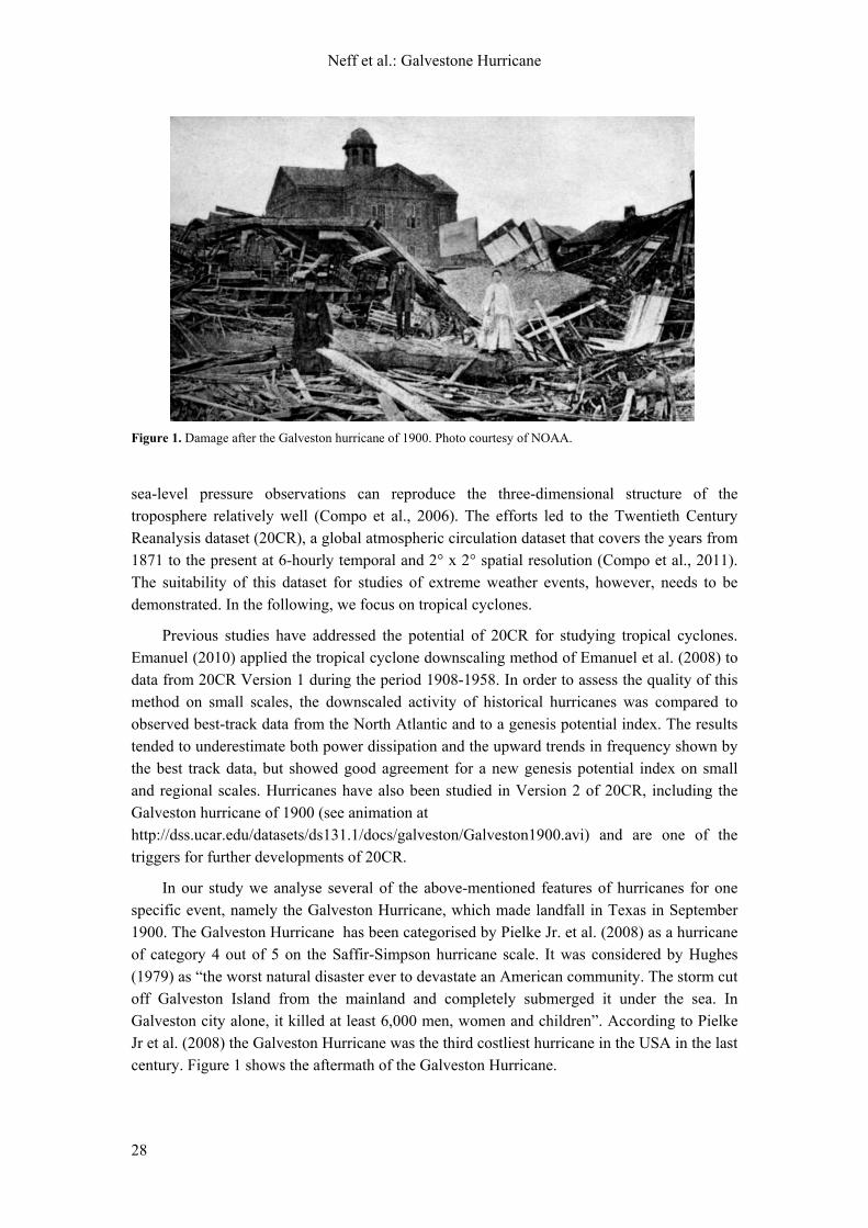
Figure 1. Damage after the Galveston hurricane of 1900. Photo courtesy of NOAA.
sea-level pressure observations can reproduce the three-dimensional structure of the troposphere relatively well (Compo et al., 2006). The efforts led to the Twentieth Century Reanalysis dataset (20CR), a global atmospheric circulation dataset that covers the years from 1871 to the present at 6-hourly temporal and 2° x 2° spatial resolution (Compo et al., 2011). The suitability of this dataset for studies of extreme weather events, however, needs to be demonstrated. In the following, we focus on tropical cyclones.
Previous studies have addressed the potential of 20CR for studying tropical cyclones. Emanuel (2010) applied the tropical cyclone downscaling method of Emanuel et al. (2008) to data from 20CR Version 1 during the period 1908-1958. In order to assess the quality of this method on small scales, the downscaled activity of historical hurricanes was compared to observed best-track data from the North Atlantic and to a genesis potential index. The results tended to underestimate both power dissipation and the upward trends in frequency shown by the best track data, but showed good agreement for a new genesis potential index on small and regional scales. Hurricanes have also been studied in Version 2 of 20CR, including the Galveston hurricane of 1900 (see animation at http://dss.ucar.edu/datasets/ds131.1/docs/galveston/Galveston1900.avi) and are one of the triggers for further developments of 20CR.
In our study we analyse several of the above-mentioned features of hurricanes for one specific event, namely the Galveston Hurricane, which made landfall in Texas in September 1900. The Galveston Hurricane has been categorised by Pielke Jr. et al. (2008) as a hurricane of category 4 out of 5 on the Saffir-Simpson hurricane scale. It was considered by Hughes (1979) as “the worst natural disaster ever to devastate an American community. The storm cut off Galveston Island from the mainland and completely submerged it under the sea. In Galveston city alone, it killed at least 6,000 men, women and children”. According to Pielke Jr et al. (2008) the Galveston Hurricane was the third costliest hurricane in the USA in the last century. Figure 1 shows the aftermath of the Galveston Hurricane.

Neff et al.: Galvestone Hurricane
29
2. Data and Methods
20CR is an atmospheric reanalysis that is based on the assimilation of only surface and sea-level pressure data (Compo et al., 2011). The reanalysis uses the NCEP/CFS model at a spectral truncation of T62, corresponding to a horizontal resolution of 2° x 2°, and 28 levels in the vertical. The model was forced with monthly sea-surface temperatures and sea ice concentrations as boundary conditions (Rayner et al., 2003). An Ensemble Kalman Filter is used for the assimilation, and the ensemble consists of 56 equally likely members. In order to assimilate hurricane information, tropical cyclone tracks from the International Best Track Archive for Climate Stewardship (IBTrACS) were assimilated by attributing to each point of the track a pressure value. Figure 2 shows the locations of pressure measurements that were assimilated into 20CR in the case of the Galveston hurricane, the IBTrACS for the hurricane as well as the land-sea mask of the 20CR model. Considering cyclones, the ensemble mean is expected to cause a slight spatio-temporal smoothing of amplitude and gradients in a given field (see Brönnimann et al., this volume). For studying extremes, it is therefore advisable to analyse the individual ensemble members.
In this study we use the ensemble mean and the ensemble standard deviation in order to examine sea level pressure and wind. Furthermore we use the individual ensemble members in order to analyse the tracks. At each time step, the location of the minimum pressure was interpolated according to Eq. (1) separately for longitude and latitude:
)p,max(pp2
pp
110
11min
0
(1)
where p−1 and p1 refer to the pressure at the grid points east and west (or north and south), respectively, of the minimum in the gridded pressure field (p0), φ0 is the latitude (or longitude)
Figure 2. Map of the Gulf of Mexico area showing the surface and sea-level pressure data assimilated for the analysis of 8 September 1900, 6 UTC, as well as the land sea mask of 20CR as depicted in the Gaussian grid (192 x 94 cells). The hurricane track is shown with white dots; Galveston is marked with a red dot.

Neff et al.: Galvestone Hurricane
30
Figure 3. Schematic depiction of the approach used for determining longitude and latitude of the pressure minima.
of p0, and Δφ is the resolution of 20CR, i.e., 2°. A sketch is given in Figure 3. Equation (1) follows from the assumption that from the “true” point of minimum pressure along a given axis, pressure increases symmetrically to both sides. The rate is equal to the steeper of the two rates emanating from the grid point of minimum pressure. To get a clear track at the beginning and at the end of the life cycle of the storm, the track is only calculated if p0 was below 1000 hPa.
3. Results
The location of the hurricane is best visible in the sea-level pressure field. To the east side of Cuba, where the hurricane formed, and about one week prior to the landfall on 8 September 1900, a sea-level pressure minimum caused by the cyclone is visible (Fig. 4). After passing Cuba, the central pressure of the cyclone decreased rapidly until landfall occurred (Fig. 5). The minimum pressure, in the ensemble mean, is 970 hPa with a standard deviation of 3 hPa on 8 September 1900.
Figure 4. Ensemble mean sea-level pressure (colour shading), ensemble standard deviations of sea-level pressure (grey contours, at 1 hPa intervals, bold grey line denotes the 5 hPa contour) and wind at the 0.995 sigma level (ca. 40 m above model surface, black arrows) on 2 September 1900, 12 UTC. The red dot denotes the position of Galveston.

Neff et al.: Galvestone Hurricane
31
Figure 5. Ensemble mean sea-level pressure (colour shading), ensemble standard deviation of sea-level pressure (grey contours, at 0.5 hPa intervals, bold grey line denotes the 2 hPa contour) and ensemble mean 10 m wind (black arrows) in the Gulf of Mexico during the Galveston Hurricane for 7 September 1900, 12:00 UTC (top left), 8 September 1900, 00:00 UTC (top right), 8 September 1900, 12:00 UTC (bottom left), and 9 September 1900, 00:00 UTC (bottom right). The red dot denotes the position of Galveston.
The ensemble standard deviation is shown by grey contour lines in Figures 4 and 5. The standard deviations have their highest values close to the centre of the hurricane. The standard deviations in high pressure areas are very small. Furthermore the standard deviations over the ocean are larger than the standard deviations over land.
In the beginning of the hurricane development (Fig. 4) the standard deviations around the centre of the tropical cyclone were very high (7 hPa on 2 September 1900). After having reached the Gulf of Mexico, the standard deviations remained around 3 hPa. The wind field at the lowermost level is very distinctive in Figure 5 and shows a cyclonic rotation. The symmetric form of the hurricane is visible in the wind field. The wind speed increases with decreasing central pressure. The highest winds in 20CR occurred on 8 September with 45 ms−1. A very small wind vector can be identified in the centre of the hurricane, although this is not expected to really represent the fine details and strong gradients occurring in a real hurricane eye, considering the resolution of 2° x 2°.
The tracks of the hurricane for every ensemble member are visualised in Figure 6. In the beginning of the life cycle of the hurricane the different tracks disagree by roughly 400 km in north-south direction, even though the IBTrACS track (black line in Fig. 6) reaches further to the east. Arguably sea-level pressure minima in each member were close to or above the threshold used (1000 hPa) and the ensemble spread was high (Fig. 4). After passing Cuba, the disagreement of the tracks decreases. Most of the ensemble tracks follow roughly the same line, with the notable exception of two tracks, one (blue in Fig 6) passing south of Cuba and another one (orange) turning towards Mexico after landfall.

Neff et al.: Galvestone Hurricane
32
Figure 6. Tracks of the Galveston hurricane from all ensemble members of 20CR calculated according to Eq. 1. One coloured line represents one ensemble member minimum pressure over time (from east to west) from 2 September 1900 to 12 September 1900. Positions were only calculated if sea-level pressure dropped below 1000 hPa between. Galveston is marked with a green dot on the map. The black line represents the assimilated “Best Track” from IBTrACS (http://www.ncdc.noaa.gov/oa/ibtracs/).
4. Discussion
Comparing the 20CR tracks with the “Best Track” data, two phases can be distinguished. The first phase begins over the Atlantic Ocean and ends when the hurricane enters the Gulf of Mexico. The second phase represents the remainder of the tracks. Since all 20CR ensemble member tracks roughly cross Galveston, they can, at least for the second part, basically be considered close to reality (Fig. 6). The partial disagreement of the tracks after landfall (where the “Best Track” from IBTrACS continues a far distance over land, see Fig. 6) and at the beginning over the Atlantic Ocean might be due to the thresholds used (1000 hPa) and perhaps also due to limitations of our very simple tracking using Eq. 1.
Considering the overlap of the ensemble with IBTrACS as a measure of agreement, there seems to be substantial disagreement east of the Strait of Florida (despite the large ensemble spread there), upon entering the Gulf of Mexico (where the 20CR standard deviation is small), and after landfall, where 20CR tracks mostly continue westward while the IBTrACS “Best Track” turns sharply to the north. Tracks in 20CR are too far south for most of the track. Again, our very simple tracking (Eq. 1) assuming symmetric gradients might be wrong, and better algorithms might have to be used.
Concerning the general structure of the hurricane, 20CR shows many of the features realistically. According to Hawkins and Rubsam (1968) the eye of a hurricane is the region of lowest surface pressure. It is a more or less circular area of comparatively light winds and fair weather found at the centre of severe tropical cyclones (Hawkins and Rubsam, 1968). This is in agreement with the 20CR ensemble mean where the wind in the centre of the hurricane is

Neff et al.: Galvestone Hurricane
33
weaker. Emanuel (2003) states, that winds increase rapidly outward from the centre and then fall off more gradually with increasing distance from the cyclone centre (Emanuel, 2003). These characteristics of a tropical cyclone are qualitatively well reproduced in the 20CR ensemble mean (Fig. 6), even though the detailed structure of the eye and the very strong pressure gradient close to the eye’s walls are obviously not adequately simulated at the 2° x 2° resolution. Concerning the ensemble spread in sea-level pressure in 20CR, there are large areas of small ensemble standard deviations further away from the hurricane towards the subtropical high, but large standard deviations near the centre of the storm.
One factor that does not agree well is maximum wind speed. The wind speeds in 20CR are much smaller than the required wind speeds for a hurricane of category 4 on the Saffir-Simpson scale. As mentioned already, coarse resolution and inadequate model physics may prevent models to reproduce the maximum wind speeds. Here, a downscaling may yield better results.
The kinetic energy of hurricanes is maintained in the presence of boundary layer dissipation by conversion of latent heat energy acquired from the underlying ocean (Holton, 1992). Therefore the intensity of a hurricane decreases substantially once it has made landfall. This feature is well represented in 20CR.
5. Conclusions
The Twentieth Century Reanalysis dataset (20CR) qualitatively reproduces several characteristic features of the Galveston Hurricane. All ensemble members show almost the same track in the Gulf of Mexico, as illustrated in Figure 6 but also in the small standard deviation of the pressure in Figure 5. For hurricanes over the North Atlantic Ocean away from station observations, the 20CR data has possibly not the same quality as in the Gulf of Mexico. This is apparent in Figure 6 in the beginning of the simulated hurricane tracks over the Atlantic, which deviate strongly from each other. However, we find systematic and significant differences with the assimilated IBTrACS “Best Track” in both the Atlantic and the Gulf of Mexico as well as after landfall, at least when considering the full range of all 56 ensemble members to be representative of total model uncertainty. The cause of these differences could not conclusively be established in this paper.
The near-surface wind field of the hurricane in 20CR realistically depicts several expected features such as a relatively calm zone close to the centre of the hurricane in the ensemble mean.
Quantitatively the hurricane has been categorised as a hurricane of category 4 on the Saffir-Simpson scale. The maximum wind speed in our data (and accordingly the maximum pressure gradients) was strongly underestimated with only 45 ms−1 which according to Schott et al. (2012) corresponds only to a hurricane of category 2. One reason is that coarse resolution models such as the one used in 20CR seem to systematically underestimate the potential intensity of hurricanes (Emanuel, 2010).

Neff et al.: Galvestone Hurricane
34
Acknowledgments
20CR data were obtained courtesy of the NOAA/OAR/ESRL PSD, Boulder, Colorado, USA, from their Web site at http://www.esrl.noaa.gov/psd/. Support for the Twentieth Century Reanalysis Project dataset is provided by the U.S. Department of Energy, Office of Science Innovative and Novel Computational Impact on Theory and Experiment (DOE INCITE) program, and Office of Biological and Environmental Research (BER), and by the NOAA Climate Goal. The project used resources of the National Energy Research Scientific Computing Centre and of the National Centre for Computational Sciences at Oak Ridge National Laboratory, which are supported by the Office of Science of the U.S. Department of Energy under Contract No. DE-AC02-05CH11231 and Contract No. DE-AC05-00OR22725, respectively. The work was supported by the Swiss National Science Foundation (Project “EVALUATE”) and by the EC FP7 project ERA-CLIM.
References
Brönnimann, S., O. Martius, J. Franke, A. Stickler, and R. Auchmann (2013) Historical weather extremes in the “Twentieth Century Reanalysis”. In: Brönnimann, S. and O. Martius (Eds.) Weather extremes during the past 140 years. Geographica Bernensia G89, p. 7-17, DOI: 10.4480/GB2013.G89.01.
Compo, G. P., J. S. Whitaker, and P. D. Sardeshmukh (2006) Feasibility of a 100-Year Reanalysis Using Only Surface Pressure Data. Bull. Amer. Meteor. Soc., 87, 175–190.
Compo, G. P., J. S. Whitaker, P. D. Sardeshmukh, N. Matsui, R. J. Allan, X. Yin, B. E. Gleason, R. S. Vose, G. Rutledge, P. Bessemoulin, S. Brönnimann, M. Brunet, R. I. Crouthamel, A. N. Grant, P. Y. Groisman, P. D. Jones, M. C. Kruk, A. C. Kruger, G. J. Marshall, M. Maugeri, H. Mok, O. Nordli, T. F. Ross, R. M. Trigo, X. L. Wang, S. D. Woodruff, and S. J. Worley (2011) The Twentieth Century Reanalysis Project. Q. J. Roy. Meteorol. Soc., 137, 1–28.
Emanuel, K. (2003) Tropical Cyclones. Ann. Rev. Earth Planet. Sci., 31, 75–104. Emanuel, K. (2010) Tropical Cyclone Activity Downscaled from NOAA-CIRES Reanalysis, 1908-1958. J. Adv.
Model. Earth Syst, 2, DOI:10.3894/JAMES.2010.2.1. Emanuel, K., R. Sundararajan, and J. Williams, J. (2008) Hurricanes and Global Warming: Results from
Downscaling IPCC AR4 Simulations. Bull. Amer. Meteorol. Soc., 89, 347–367. Hawkins, H. F. and D. T. Rubsam (1968) Hurricane Hilda, 1964. Mon. Wea. Rev., 96, 617–636. Holton, J. R. (1992) An introduction to dynamic meteorology. Academic Press, San Diego, 3rd ed. edition. Hughes, P. (1979) The great Galveston hurricane. Weatherwise, 32, 148–156. Pielke Jr, R. A., J. Gratz, C. W. Landsea, D. Collins, M. A. Saunders, and R. Musulin (2008) Normalized
Hurricane Damage in the United States: 1900–2005. Natural Hazards Review, 9, 29–42. Rayner, N. A., D. E. Parker, E. B. Horton, C. K. Folland, L. V. Alexander, D. P. Rowell, E. C. Kent, and A.
Kaplan (2003) Global analyses of sea surface temperature, sea ice, and night marine air temperature since the late Nineteenth Century. J. Geophys. Res., 108, 4407, doi:10.1029/2002JD002670.
Schott, T., C. Landsea, G. Hafele, J. Lorens, A. Taylor, H. Thurm, B. Ward, M. Willis, and W. Zaleski (2012) The Saffir-Simpson Hurricane Wind Scale. http: http://www.nhc.noaa.gov/pdf/sshws.pdf. [accessed 7 February 2013].


![[ 6.7 ] A Hurricane and the Oil Boom. Learning Objectives Understand why the Galveston Hurricane caused a large amount of destruction. Explain the ways](https://img.pdfslide.us/doc/110x75/56649ce35503460f949aff6e/-67-a-hurricane-and-the-oil-boom-learning-objectives-understand-why-the.jpg)