Embed Size (px)
Citation preview
An Analysis of River Bank Slope and UnsaturatedFlow Effects on Bank Storageby Rebecca Doble1, Philip Brunner2,3, James McCallum2,4, and Peter G. Cook2,4,5
AbstractRecognizing the underlying mechanisms of bank storage and return flow is important for understanding
streamflow hydrographs. Analytical models have been widely used to estimate the impacts of bank storage, butare often based on assumptions of conditions that are rarely found in the field, such as vertical river banks andsaturated flow. Numerical simulations of bank storage and return flow in river-aquifer cross sections with verticaland sloping banks were undertaken using a fully-coupled, surface-subsurface flow model. Sloping river bankswere found to increase the bank infiltration rates by 98% and storage volume by 40% for a bank slope of 3.4◦ fromhorizontal, and for a slope of 8.5◦, delay bank return flow by more than four times compared with vertical riverbanks and saturated flow. The results suggested that conventional analytical approximations cannot adequately beused to quantify bank storage when bank slope is less than 60◦ from horizontal. Additionally, in the unconfinedaquifers modeled, the analytical solutions did not accurately model bank storage and return flow even in riverswith vertical banks due to a violation of the dupuit assumption. Bank storage and return flow were also modeledfor more realistic cross sections and river hydrograph from the Fitzroy River, Western Australia, to indicate theimportance of accurately modeling sloping river banks at a field scale. Following a single wet season flood eventof 12 m, results showed that it may take over 3.5 years for 50% of the bank storage volume to return to the river.
IntroductionBank storage is an important hydrological process.
It can reduce flood intensity at downstream sites as theflood hydrograph peak is reduced and delayed becauseevent water is stored within the saturated and unsatu-rated zones of the alluvial aquifer. Bank storage thensustains flow in streams for some time after flood events as
1Corresponding author: Water for a Healthy Country, NationalResearch Flagship, CSIRO Land and Water, Adelaide, SA, Australia;[email protected]
2School of Chemistry, Physics and Earth Sciences, FlindersUniversity, Adelaide, Australia.
3Centre for Hydrogeology and Geothermics, University ofNeuchatel, Switzerland.
4National Centre for Groundwater Research and Training,Adelaide, SA, Australia.
5Water for a Healthy Country, National Research Flagship,CSIRO Land and Water, Adelaide, SA, Australia.
Received October 2010, accepted March 2011.© 2011, CSIROGround Water © 2011, National Ground Water Association.doi: 10.1111/j.1745-6584.2011.00821.x
the stream stage recedes. Where regional groundwater issaline, bank storage can provide a fresh source of ground-water to streams for sustained periods of time followingflow events.
Analytical models are widely used for estimating thedynamics of bank storage. Cooper and Rorabaugh (1963)provided analytical solutions for changes in watertable,flow, and bank storage occurring from a single flood waveoscillation in both finite and semi-infinite aquifers with avertical river bank. They showed that in infinite aquifers,the return flow from bank storage after the flood wave haspassed is very slow, with 50% of the bank storage volumereturned to the river after 1.3 flood wave periods (t = τ )and 90% returned after 18 flood wave periods. Rorabaugh(1964) then used these models to estimate changes in bankstorage and groundwater contribution to streamflow forthe Bitterroot River basin in Montana, USA. This includedgroundwater recharge from irrigation and precipitation.
Hall and Moench (1972) applied the convolutionequation to solve for groundwater flow and head varia-tions due to stream perturbations for four idealized cases
NGWA.org Vol. 50, No. 1–GROUND WATER–January-February 2012 (pages 77–86) 77
of finite and semi-infinite aquifers with and without semi-pervious stream banks. This allowed input flood pulsesof an arbitrary shape to be used. Moench et al. (1974)then used the convolution equation to model channel lossand base flow resulting from a reservoir release in cen-tral Oklahoma. On the basis of this method, Hunt (1990)used a perturbation approach to calculate an approximateflood-routing solution for the coupled groundwater andopen channel flow equations in order to apply the bankstorage effects discussed in the study by Moench et al.(1974) longitudinally down a river.
Limitations to the above-mentioned bank storagemodels include assumptions of homogeneity, validDupuit-Forchheimer conditions, fully penetrating streams,vertical river banks, and bank storage return undersaturated conditions. These conditions are rarely foundin the field, as highlighted by Sharp (1977). From ourbest knowledge, all of the analytical solutions are basedon these assumptions. A quantitative assessment of mostof these assumptions, however, has so far not beencarried out.
Whiting and Pomeranets (1997) modeled return flowafter an instantaneous river stage reduction from alluvialaquifers using a two-dimensional (2-D) numerical modelwith a free surface watertable and partially penetratingriver. For the widest floodplain scenario presented, resultswere similar to those of Cooper and Rorabaugh (1963) andRorabaugh (1964), with depletion of bank storage takingover 7 months for 50% of the water to drain from thebank for a sand aquifer. Recently, Chen and Chen (2003)and Chen et al. (2006) modeled streamflow infiltration andbank storage changes in a partially penetrating streamdue to stage fluctuations using the numerical groundwa-ter model, MODFLOW. They noted changes in the rate ofinfiltration and baseflow as a response to a series of param-eters, including river hydrographs, hydraulic conductivityof the streambed and the underlying aquifer, and regionalgroundwater gradients. Both of these studies assumed ver-tical river banks, and did not explicitly model unsaturatedzone processes using the full Richards Equation.
The first study to look at the impacts of slopingriver banks was done by Li et al. (2008a). Dimensionlessnumerical simulations were undertaken to quantify bankstorage in variably saturated, homogeneous, anisotropicaquifers with fully penetrating rivers with variable bankslopes, as a result of a simulated flood event using themodel described by Boufadel et al. (1999). The studydetermined that bank storage was an increasing func-tion of the rate of stream level rise, that smaller domainaspect ratios (or smaller bank slope) resulted in largerbank storage volumes due to a larger bank surface areafor a given river stage. They also included an unsaturatedzone, showing that materials with a low capillary suctionresulted in higher volumes of bank storage. Also usingdimensionless numerical relationships, Naba et al. (2002)and Li et al. (2008b) modeled similar problems associatedwith seepage flows and tidal seawater-groundwater inter-actions. The model used did not, however, consider thereturn flow of bank storage into the river, and therefore
could not determine how these variables affected the rateof return flow.
McCallum et al. (2010) modeled solute dynamicsduring bank storage and return flow for confined andunconfined aquifers and rivers with vertical banks, includ-ing single wave and multiple streamflow wave events.They observed vertical head gradients present in the unsat-urated models due to the pressure head moving morequickly in the deep part of the aquifer than at the watertable. As a result, they suggested that it was important tomodel the unsaturated zone near the stream environmentto accurately simulate the bank storage process. The studyalso showed that including the unsaturated zone reducedthe magnitude of the return flow peak compared with mod-els that assume saturated flow conditions.
For the conceptual approach of MODFLOW 2000(Harbaugh et al., 2000), it is assumed that the stream is arectangular shape with vertical banks and flux exchangethrough the stream bed. To model rivers with slopingbanks, it would be necessary to create a stepped riverprofile with localized fine discretization, or use a depthdependent conductance term, which may be possible withthe SFR2 package of MODFLOW (Niswonger and Prudic,2005).
This paper explores the implications of assuming avertical river bank and not allowing for variable satura-tion for calculations of bank storage fluxes and the returnflow. Generic simulations use a regular cosine-wave vari-ation in the river level and a triangular-shaped river toexplore the role of bank slope on bank storage processes.Additional simulations using more realistic river hydro-graph and floodplain geometries have been modeled onthe Fitzroy River in Western Australia.
Conceptualization and Model Development
Generic SimulationsGeneric simulations of a river-aquifer transect per-
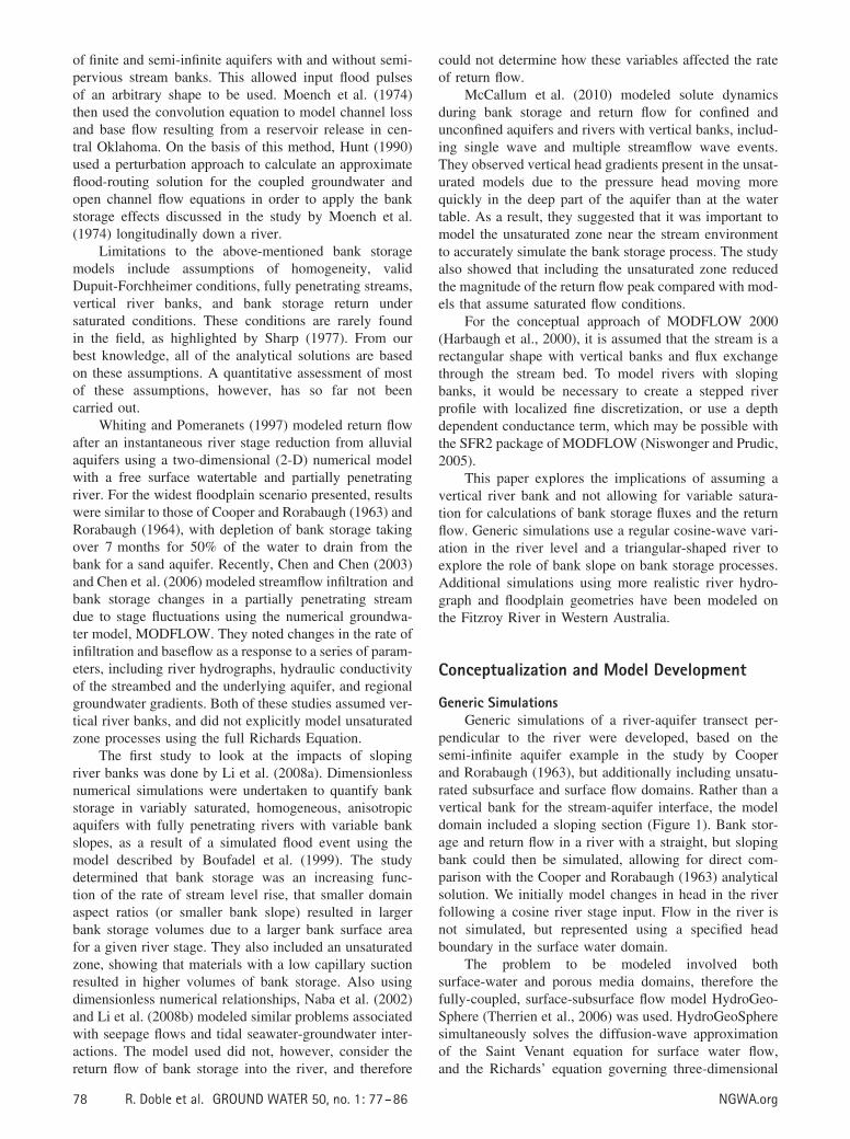
pendicular to the river were developed, based on thesemi-infinite aquifer example in the study by Cooperand Rorabaugh (1963), but additionally including unsatu-rated subsurface and surface flow domains. Rather than avertical bank for the stream-aquifer interface, the modeldomain included a sloping section (Figure 1). Bank stor-age and return flow in a river with a straight, but slopingbank could then be simulated, allowing for direct com-parison with the Cooper and Rorabaugh (1963) analyticalsolution. We initially model changes in head in the riverfollowing a cosine river stage input. Flow in the river isnot simulated, but represented using a specified headboundary in the surface water domain.
The problem to be modeled involved bothsurface-water and porous media domains, therefore thefully-coupled, surface-subsurface flow model HydroGeo-Sphere (Therrien et al., 2006) was used. HydroGeoSpheresimultaneously solves the diffusion-wave approximationof the Saint Venant equation for surface water flow,and the Richards’ equation governing three-dimensional
78 R. Doble et al. GROUND WATER 50, no. 1: 77–86 NGWA.org
(a)
(b)
Figure 1. Bank cross sections used in the study with (a) vertical and (b) sloping river/aquifer interfaces (not to scale). Bankangle (α) is defined in degrees from a horizontal plane. Actual aquifer dimensions are 4 m thick and 250 m long.
(3-D) unsaturated/saturated subsurface flow with a phys-ical coupling between the two domains. The ability ofHydroGeoSphere to simulate bank storage and unsaturatedzone processes in rivers with vertical banks has been veri-fied by Brunner et al. (2009) and McCallum et al. (2010).
In this paper, the 250-m-wide, 4-m-thick aquifer wasmodeled as homogeneous and isotropic with an imperme-able base and constant head on the right hand boundary.The stream was fully penetrating. Rainfall and evapotran-spiration were not considered in this study. A series ofriver bank scenarios were modeled, based on bank slopesranging from vertical (90◦ from horizontal) to an angle of3.4◦ from horizontal, as shown in Table 1.
The model was run using the finite differenceapproach. To maintain a high level of accuracy whensimulating coupled flows across the surface and vari-ably saturated subsurface, the model required localizeddiscretization near the river to 5 mm horizontally, and20 mm vertically, particularly for the less steeply slopingexamples. Further from the river, a coarser discretizationof 10 m was applied. Adaptive time-stepping was used,with a maximum time-step of 0.1 d, and it was neces-sary to model the problem in steady state first in order toimport initial saturation conditions. The initial river heightand aquifer saturated thickness was 2.0 m.
The river flood pulse (�) was defined using aspecified head boundary applied to model cells withinthe permanently saturated part of the river, given by the
equation:
ψ(t) ={
(h0/2)(1 − cos ωt), when 0 ≤ t ≤ τ
0, when t > τ(1)
where h0 is the maximum rise in stage, t is the time sincethe beginning of the flood wave, τ is the duration of thewave and (Cooper and Rorabaugh 1963). The wave heighth0 was 1 m and the wave length was 5 d.
Table 1Bank Slope Dimensions and Associated Angles
Used in This Study
Angle (Degrees froma Horizontal Plane) Slope 1:x
90 088.1 0.03371.6 0.3356.3 0.6731 1.6716.7 3.338.5 6.675.7 10.04.3 13.33.4 16.7
NGWA.org R. Doble et al. GROUND WATER 50, no. 1: 77–86 79
The aquifer is conceptualized as a zone of porousmedia, overlain by overland flow cells (Figure 1). Theoverland flow cells allow the river to flow up its banks,so that the river width increases during high flows. Thedomains were linked with a dual node arrangement, witha coupling length of 0.01 m.
Specified head cells were assigned to the over-land flow cells beneath the initial water table position(Figure 1). Initial conditions included a constant pres-sure head within the aquifer and river, which were inequilibrium. The flood wave was applied to these cells.The overland flow parameters were chosen in a wayso that there was no resistance and therefore no delayin the propagation of the wave in the surface domain.These consisted of a friction factor (Manning’s n) of10−5 s m−1/3 in both x and y directions, rill storageheight of 0.00001 m and an obstruction storage heightof 0 m.
Soil parameters for the porous media domain werebased on a sandy loam from the soil types describedby Carsel and Parrish (1988), shown in Table 2. Thescenarios were also modeled using pseudo-soil param-eters to remove the effect of the unsaturated zone. InHydroGeoSphere, it is not possible to switch off theunsaturated zone, but it is possible to get very closeto this approximation by using pseudo-soil parameters,where the vertical hydraulic conductivity (Kv) is inde-pendent of the degree of saturation. This represented thesystem without an unsaturated zone, necessary to both val-idate the model against the analytical solution and separatethe individual effects of river bank slope and unsaturatedzone.
This model was initially used for a comparison withthe analytical solution, and then to test the scenariosdescribed above. Results were presented as the flux intothe river bank varying with time and the proportion ofwater volume that had infiltrated the river bank that wasstill held in storage (“bank storage remaining”) vary-ing with dimensionless time. The results for a verticalbank matched the analytical solution for the proportionof bank storage remaining well. Results did not changewith alterations of the right boundary condition betweenno-flow and constant head, and as the right boundary
Table 2Soil and Aquifer Parameters Used in the
Scenarios Modeled
Parameter UnitsScenarioValues
Saturated water content (θ s) — 0.41Residual water content (θ r) — 0.158Saturated hydraulic conductivity (Ks) m/d 1.06Isotropic ratio (KV:KH) — 1.0van Genuchten α m−1 7.5N (or β) — 1.89Specific storage (Ss) — 10−4
was located sufficiently far away that the results were notaffected by the boundary condition, the aquifer approxi-mated the semi-infinite system represented by the Cooperand Rorabaugh (1963) problem.
Realistic River Geometry and HydrographA series of simulations were also performed using
realistic river cross sections and flood hydrographs. Forthese simulations cross sections and hydrographs fromthe Fitzroy River in Western Australia were used. How-ever, the modeling is intentionally not fully representativeof the field situation, as the effects of riparian evap-otranspiration and regional groundwater gradients, forexample, would obscure the impacts of the slopingbank. The intent of the following section is to observethe isolated effects of river bank slope in a field-scaleexample.
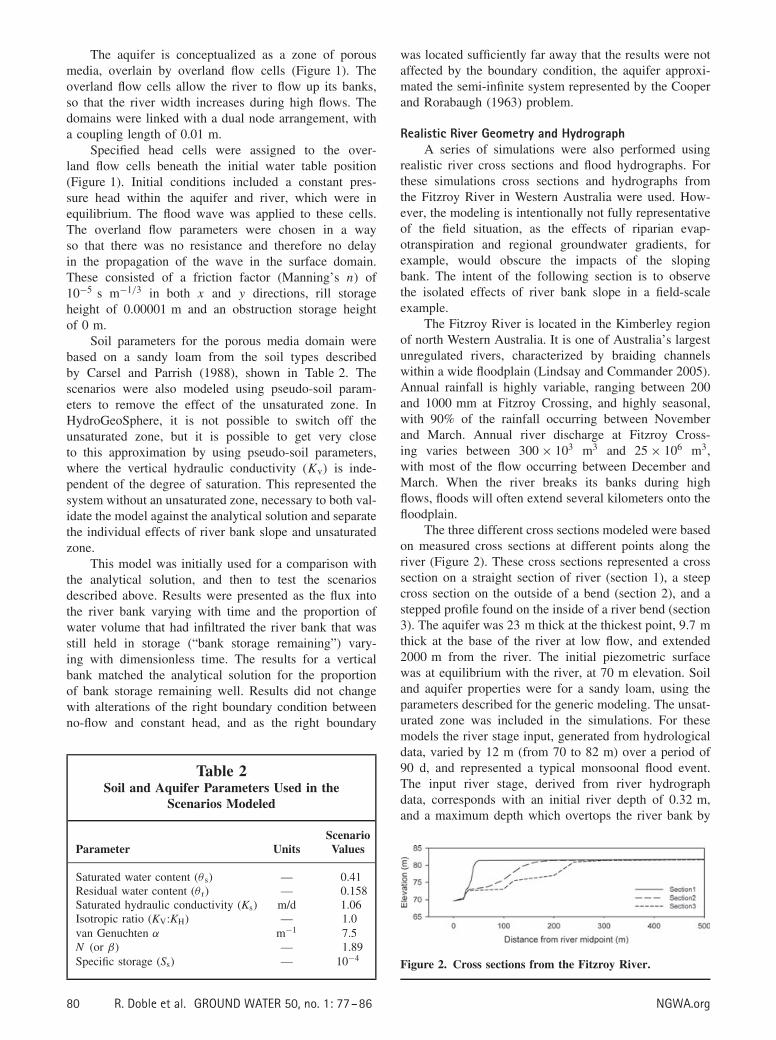
The Fitzroy River is located in the Kimberley regionof north Western Australia. It is one of Australia’s largestunregulated rivers, characterized by braiding channelswithin a wide floodplain (Lindsay and Commander 2005).Annual rainfall is highly variable, ranging between 200and 1000 mm at Fitzroy Crossing, and highly seasonal,with 90% of the rainfall occurring between Novemberand March. Annual river discharge at Fitzroy Cross-ing varies between 300 × 103 m3 and 25 × 106 m3,with most of the flow occurring between December andMarch. When the river breaks its banks during highflows, floods will often extend several kilometers onto thefloodplain.
The three different cross sections modeled were basedon measured cross sections at different points along theriver (Figure 2). These cross sections represented a crosssection on a straight section of river (section 1), a steepcross section on the outside of a bend (section 2), and astepped profile found on the inside of a river bend (section3). The aquifer was 23 m thick at the thickest point, 9.7 mthick at the base of the river at low flow, and extended2000 m from the river. The initial piezometric surfacewas at equilibrium with the river, at 70 m elevation. Soiland aquifer properties were for a sandy loam, using theparameters described for the generic modeling. The unsat-urated zone was included in the simulations. For thesemodels the river stage input, generated from hydrologicaldata, varied by 12 m (from 70 to 82 m) over a period of90 d, and represented a typical monsoonal flood event.The input river stage, derived from river hydrographdata, corresponds with an initial river depth of 0.32 m,and a maximum depth which overtops the river bank by
Figure 2. Cross sections from the Fitzroy River.
80 R. Doble et al. GROUND WATER 50, no. 1: 77–86 NGWA.org
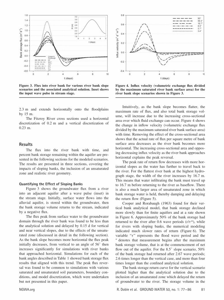
Figure 3. Flux into river bank for various river bank slopescenarios and the associated analytical solution. Inset showsthe input wave pulse in stream stage.
2.3 m and extends horizontally onto the floodplainsby 15 m.
The Fitzroy River cross sections used a horizontaldiscretization of 0.2 m and a vertical discretization of0.23 m.
ResultsThe flux into the river bank with time, and
percent bank storage remaining within the aquifer are pre-sented in the following sections for the modeled scenarios.The results are presented in three sections, covering theimpacts of sloping banks, the inclusion of an unsaturatedzone and realistic river geometry.
Quantifying the Effect of Sloping BanksFigure 3 shows the groundwater flux from a river
into an adjacent aquifer after a wave pulse (inset) inthe stream stage. Initially, surface water flows into thealluvial aquifer, is stored within the groundwater, thenthe bank storage volume returns to the stream, indicatedby a negative flux.
The flux peak from surface water to the groundwaterdomain through the river bank was found to be less thanthe analytical solution and delayed by 0.15 d for verticaland near vertical slopes, due to the effects of the unsatu-rated zone (discussed in detail in the following section).As the bank slope becomes more horizontal the flux peakinitially decreases, from vertical to an angle of 56◦ thenincreases significantly for simulations with river banksthat approached horizontal. Simulations for each of thebank angles described in Table 1 showed bank storage fluxresults that aligned with this trend. The peak flux rever-sal was found to be common to simulations with varioussaturated and unsaturated soil parameters, boundary con-ditions, and model discretization, which were undertakenbut not presented in this paper.
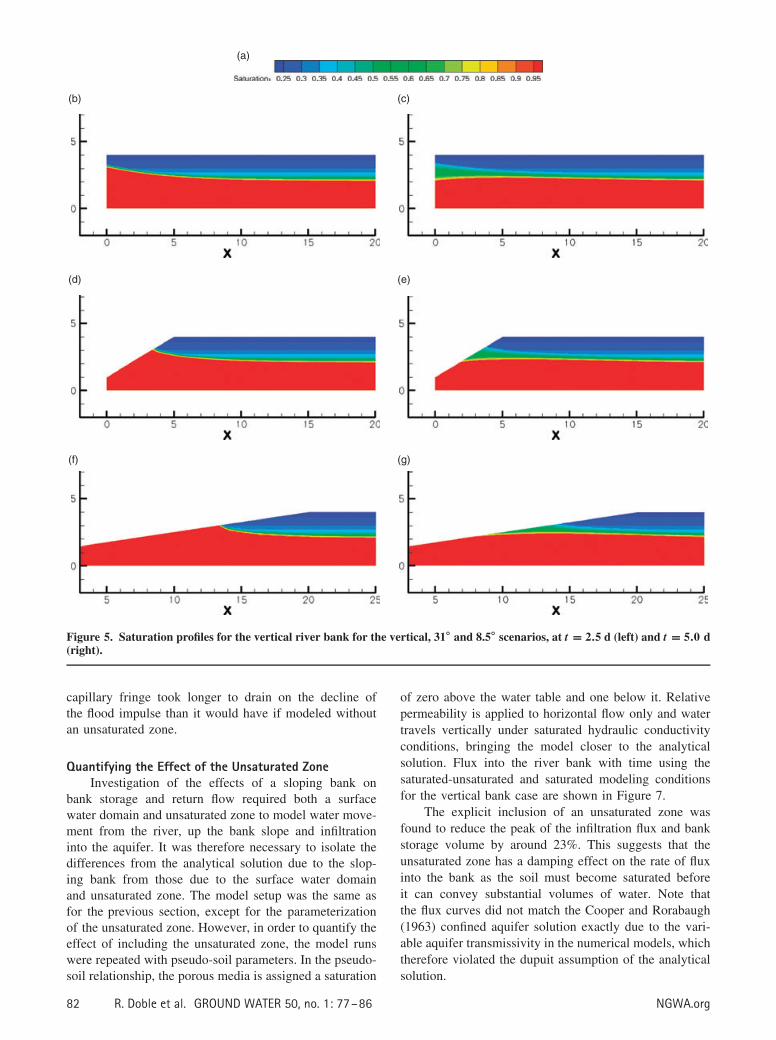
Figure 4. Influx velocity (volumetric exchange flux dividedby the maximum saturated river bank surface area) for theriver bank slope scenarios shown in Figure 3.
Intuitively, as the bank slope becomes flatter, themaximum rate of flux, and also total bank storage vol-ume, will increase due to the increasing cross-sectionalarea over which fluid exchange can occur. Figure 4 showsthe change in inflow velocity (volumetric exchange fluxdivided by the maximum saturated river bank surface area)with time. Removing the effect of the cross-sectional areashows that the actual rate of flux per square metre of banksurface area decreases as the river bank becomes morehorizontal. The increasing cross-sectional area and oppos-ing decreasing influx velocity as the river bank approacheshorizontal explains the peak reversal.
The peak rate of return flow decreases with more hor-izontal slopes as the water has further to travel back tothe river. For the flattest river bank at the highest hydro-graph stage, the width of the river increases by 16.7 m.This means that water infiltrating the bank must travel upto 16.7 m before returning to the river as baseflow. Thereis also a much larger area of unsaturated zone in whichbank storage water is held, thereby damping and delayingthe return flow (Figure 5).
Cooper and Rorabaugh (1963) found for their ver-tical bank analytical model, that bank storage declinedmore slowly than for finite aquifers and at a rate shownin Figure 6. Approximately 50% of the bank storage hadreturned to the river after 0.6 wave periods (t /τ*), whilefor rivers with sloping banks, the numerical modelingindicated much slower rates of return (Figure 6). Thevariable “τ” represents the flood wave period and the∗ denotes that measurement begins after the maximumbank storage volume, that is at the commencement of netflow out of the aquifer. For the 8.5◦ slope scenario, 50%of the bank storage had returned after 2.67 wave periods;2.6 times longer than the vertical case, and more than fourtimes longer than the confined analytical solution.
The bank storage return curve for the vertical scenarioplotted higher than the analytical solution due to theinclusion of an unsaturated zone which delayed the returnof groundwater to the river. The storage volume in the
NGWA.org R. Doble et al. GROUND WATER 50, no. 1: 77–86 81
(b)
(a)
(c)
(d) (e)
(f) (g)
Figure 5. Saturation profiles for the vertical river bank for the vertical, 31◦ and 8.5◦ scenarios, at t = 2.5 d (left) and t = 5.0 d(right).
capillary fringe took longer to drain on the decline ofthe flood impulse than it would have if modeled withoutan unsaturated zone.
Quantifying the Effect of the Unsaturated ZoneInvestigation of the effects of a sloping bank on
bank storage and return flow required both a surfacewater domain and unsaturated zone to model water move-ment from the river, up the bank slope and infiltrationinto the aquifer. It was therefore necessary to isolate thedifferences from the analytical solution due to the slop-ing bank from those due to the surface water domainand unsaturated zone. The model setup was the same asfor the previous section, except for the parameterizationof the unsaturated zone. However, in order to quantify theeffect of including the unsaturated zone, the model runswere repeated with pseudo-soil parameters. In the pseudo-soil relationship, the porous media is assigned a saturation
of zero above the water table and one below it. Relativepermeability is applied to horizontal flow only and watertravels vertically under saturated hydraulic conductivityconditions, bringing the model closer to the analyticalsolution. Flux into the river bank with time using thesaturated-unsaturated and saturated modeling conditionsfor the vertical bank case are shown in Figure 7.
The explicit inclusion of an unsaturated zone wasfound to reduce the peak of the infiltration flux and bankstorage volume by around 23%. This suggests that theunsaturated zone has a damping effect on the rate of fluxinto the bank as the soil must become saturated beforeit can convey substantial volumes of water. Note thatthe flux curves did not match the Cooper and Rorabaugh(1963) confined aquifer solution exactly due to the vari-able aquifer transmissivity in the numerical models, whichtherefore violated the dupuit assumption of the analyticalsolution.
82 R. Doble et al. GROUND WATER 50, no. 1: 77–86 NGWA.org
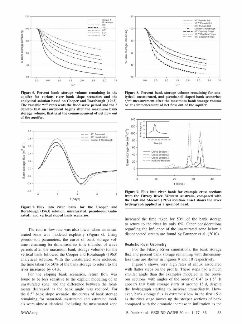
Figure 6. Percent bank storage volume remaining in theaquifer for various river bank slope scenarios and theanalytical solution based on Cooper and Rorabaugh (1963).The variable “τ” represents the flood wave period and the *denotes that measurement begins after the maximum bankstorage volume, that is at the commencement of net flow outof the aquifer.
Figure 7. Flux into river bank for the Cooper andRorabaugh (1963) solution, unsaturated, pseudo-soil (satu-rated), and vertical sloped bank scenarios.
The return flow rate was also lower when an unsat-urated zone was modeled explicitly (Figure 8). Usingpseudo-soil parameters, the curve of bank storage vol-ume remaining for dimensionless time (number of waveperiods after the maximum bank storage volume) for thevertical bank followed the Cooper and Rorabaugh (1963)analytical solution. With the unsaturated zone included,the time taken for 50% of the bank storage to return to theriver increased by 64%.
For the sloping bank scenarios, return flow wasfound to be less sensitive to the explicit modeling of anunsaturated zone, and the difference between the treat-ments decreased as the bank angle was reduced. Forthe 8.5◦ bank slope scenario, the curves of bank storageremaining for saturated-unsaturated and saturated mod-els were almost identical. Including the unsaturated zone
Figure 8. Percent bank storage volume remaining for ana-lytical, unsaturated, and pseudo-soil sloped bank scenarios;t/τ ∗ measurement after the maximum bank storage volumeor at commencement of net flow out of the aquifer.
Figure 9. Flux into river bank for example cross sectionsfrom the Fitzroy River, Western Australia, compared withthe Hall and Moench (1972) solution. Inset shows the riverhydrograph applied as a specified head.
increased the time taken for 50% of the bank storageto return to the river by only 6%. Other considerationsregarding the influence of the unsaturated zone below adisconnected stream are found by Brunner et al. (2010).
Realistic River GeometryFor the Fitzroy River simulations, the bank storage
flux and percent bank storage remaining with dimension-less time are shown in Figures 9 and 10 respectively.
Figure 9 shows very high rates of influx associatedwith flatter steps on the profile. These steps had a muchsmaller angle than the examples modeled in the previ-ous sections, with angles of the order of 0.4◦ to 1.5◦. Itappears that bank storage starts at around 15 d, despitethe hydrograph starting to increase immediately. How-ever, bank storage flux is extremely low in the first 15 das the river stage moves up the steeper sections of bankcompared with the dramatic increase in infiltration as the
NGWA.org R. Doble et al. GROUND WATER 50, no. 1: 77–86 83
Figure 10. Percent bank storage volume remaining forexample cross sections from the Fitzroy River, WesternAustralia, compared with the analytical solution for avertical bank. The Hall and Moench (1972) solution wasused to allow an irregular input wave. It produced the sameresults as the Cooper and Rorabaugh (1963) solution with asinusoidal wave.
wave reaches the flatter profiles higher up the bank. Thebank storage flux curves for the numerical models alsoshow two peaks, or three in the case of cross section 3.This is due to two effects: firstly the number of flatter seg-ments in the cross-sectional profiles (two for section 2 andthree for section 3) and secondly the shape of the inputwave. There are two rapid rises in the river hydrograph,with a small plateau in between. As bank storage flux isrelated to the rate of change of river stage rather than theabsolute stage, the results for cross section 1 and the Halland Moench solution also reflect the two peaks, despitenot having any flatter sections in their profiles. For verysteep sections of bank (e.g., cross section 1) the bank stor-age flux rate followed the analytical solution (Figure 9).The presence of a resistive layer on the river bank, suchas a deposited silt layer, would restrict the inflow of bankstorage, particularly for flatter parts of the cross sectionand overbank flow recharge.
The return flow for all three cross sections wasdelayed compared with the Hall and Moench (1972) ana-lytical solution (Figure 10). The Hall and Moench solutionallowed the use of an irregular river hydrograph with asemi-infinite aquifer with a vertical river bank. It pro-duced the same result as the Cooper and Rorabaugh (1963)solution with a sinusoidal wave input. Since the durationof the wave (τ ) is around 90 d, this figure suggests thatfor the flatter cross sections it may take over three and ahalf years for 50% of the bank storage volume to returnto the river. In reality, evapotranspiration from riparianvegetation is likely to use some of this water and returnflow to the river would be less than shown here.
Discussion
Slope AngleAs a river bank slope angle decreases, the time taken
for bank storage to return to the river increases. This is
Figure 11. Relative error in the time taken for 50% ofbank storage volume to return to the river due to theassumption of vertical banks. Actual bank angle is plottedagainst percentage variation from the 50% return time of avertical bank.
thought to be due to the longer distance to travel fromwhere the greatest volume of water infiltrates into the bankback to the river after the wave has passed (Figure 5).Thus, numerical models that represent a river with verti-cal bank slope can significantly under-predict return timesfor rivers with sloping banks. Figure 11 shows the error,or percentage difference in the time taken for 50% of thebank storage volume to return to the river (t50) for slop-ing banks compared with a vertical bank standard, plottedagainst the river bank angle. This gives an indication ofthe error associated with assuming a vertical bank in anumerical model of rivers with sloping banks. This sug-gests that in order to keep modeling errors to within areasonable limit, rivers with bank slope angles of less than60◦ should be modeled in a way that includes a slopingbank rather than using an analytical solution or numericalmodel that assumes vertical banks.
Unsaturated ZoneThe explicit inclusion of an unsaturated zone in
numerical modeling reduced the volume of bank stor-age in the vertical bank example by 23%. Birkhead andJames (2002) also note that, generally, the Cooper andRorabaugh (1963) analytical model has a tendency tounderestimate the seepage into and out of the bank zonedue to the assumption of the constant transmissivity andthat modeled bank seepage rates reduce when flow in theunsaturated zone is accounted for. This finding is impor-tant as often bank storage is modeled with either analyticalor numerical groundwater models that do not include anexplicit unsaturated zone (Hunt 1990; Chen and Chen2003; Chen et al. 2006).
The importance of including an unsaturated zone tomodel bank storage and return depends on the aquifercharacteristics. The unsaturated zone is more critical formodeling aquifers with a lower transmissivity, such assilts or loams, or where aquifers are thin relative tothe height of the flood pulse. The duration of the flood
84 R. Doble et al. GROUND WATER 50, no. 1: 77–86 NGWA.org
pulse relative to aquifer transmissivity is also likely to beimportant.
GeneralThe modeling presented in this paper did not include
other parameters that will affect bank storage and returnflow, including:
• aquifer transmissivity, likely to result in higher bankstorage with higher transmissivity;
• wave duration relative to transmissivity, with increas-ing wave duration likely to increase the bank storagevolume and delay return flow;
• aquifer thickness to wave height ratio, with potentiallyless impact of slope and unsaturated zone as the aquiferthickness increases;
• the inclusion of a silt layer overlying the riverbank,reducing and damping infiltration and return flow;
• the state of connection between river and aquifer:gaining, losing, or losing disconnected, particularlyimpacting the proportion of bank storage returning tothe river;
• regional groundwater gradients resulting from distantrecharge, increasing the rate of return flow; and
• evapotranspiration from riparian vegetation, which isexpected to significantly reduce return flow rates.
There is no provision for the last three points to beincluded in the analytical solutions for bank storage andreturn flow.
Although it was not modeled in the simulationsdescribed above, bank infiltration will be lower, and returnflow faster than presented in this study if the regionalwater table was sloping toward the stream. This has beenconfirmed by Chen et al. (2006) and McCallum et al.(2010). Similarly, evapotranspiration in the riparian zonewill locally draw down the water table in the vicinityof the river, increasing the rate of influx and reducingthe rate of return flow (Chen et al., 2006). These effectsare particularly pertinent for the field application resultsshown in Figure 10. A sloping regional watertable willdecrease the peak bank storage fluxes and hasten thereturn flow, while evapotranspiration from riparian vege-tation will act in an opposing way, increasing bank storageand reducing return flow. The overall impact on such asystem will depend on local characteristics, and requiresfurther modeling backed up by additional field monitoringto parameterise the model.
ConclusionsNumerical simulations of bank storage and return
flow were undertaken for generic river—aquifer crosssections with straight but sloping river banks. Slopingriver banks were found to increase the peak bank storageflux and volume, and delay the rate of flow returning to theriver. Explicit modeling of an unsaturated zone decreasedbank storage and the rate of influx, but delayed the rate
of return flow, more significantly in rivers with verticalbanks.
The analyses on a sandy loam aquifer presentedin this paper suggest that further investigation of theapplication of analytical and numerical approximationsthat assume vertical river banks, such as Cooper andRorabaugh (1963), to real scenarios should be undertaken.For the analyses undertaken in this paper, a bank slopeangle of less than 60◦ from a horizontal plane was atrigger to consider more sophisticated methods of anal-ysis. Similarly, the potential errors from applying theseapproximations to thin, silty, or loamy aquifers wherean unsaturated zone is likely to have a significant effectshould be considered.
Bank storage and return flow were also modeled inthree representative cross sections of the Fitzroy River,Western Australia, using a single flood pulse derived fromhistorical hydrograph information. Results suggested thatfor the flatter cross sections it may take over three and ahalf years for 50% of the bank storage volume to returnto the river.
AcknowledgmentsThis work was jointly funded by the Tropical Rivers
and Coastal Knowledge (TRaCK) consortium and theWater for a Healthy Country National Research Flagship,CSIRO. Parts of this research were funded by the SwissNational Foundation, Ambizione grant PZ00P2_126415.The authors would like to thank Professor Rene Therrien,Rob McLaren and Young-Jin Park for their assistance withHydroGeoSphere modeling, and Professor Craig Simmonsfor inspiring initial discussions. Thanks also to GlennHarrington, Brian Smerdon, Hailong Li, John Guswaand an anonymous reviewer who provided critiques thatsignificantly improved the manuscript.
ReferencesBirkhead, A.L., and C.S. James. 2002. Muskingum river routing
with dynamic bank storage. Journal of Hydrology 264:113–132.
Boufadel, M.C., M.T. Suidan, and A.S. Venosa. 1999. A numeri-cal model for density-and-viscosity-dependent flows in two-dimensional variably-saturated porous media. Journal ofContaminant Hydrology 37, no. 1-2: 1–20.
Brunner, P., P.G. Cook, and C.T. Simmons. 2009. Hydrogeo-logic controls on disconnection between surface water andgroundwater. Water Resources Research 45: W01422.
Brunner, P., C.T. Simmons, P.G. Cook, and R. Therrien.2010. Modeling surface water-groundwater interaction withMODFLOW: some considerations. Ground Water 48, no.2: 174–180; ISSN: 1745-6584.
Carsel, R.F., and R.S. Parrish. 1988. Developing joint proba-bility distributions of soil water retention characteristics.Water Resources Research 24, no. 5: 755–769.
Chen, X., D.Y. Chen, and X. Chen. 2006. Simulation ofbaseflow accounting for the effect of bank storage and itsimplication in baseflow separation. Journal of Hydrology327, no. 3-4: 539–549; ISSN: 0022-1694.
Chen, X., and X. Chen. 2003. Stream water infiltration, bankstorage, and storage zone changes due to stream-stagefluctuations. Journal of Hydrology 280, no. 1-4: 246–264;ISSN: 0022-1694.
NGWA.org R. Doble et al. GROUND WATER 50, no. 1: 77–86 85
Cooper, H.H., and M.I. Rorabaugh. 1963. Ground-water Move-ments and Bank Storage Due to Flood Stages in SurfaceStreams. Washington: United States Department of the Inte-rior, Geological Survey Water-Supply Paper 1536-J.
Hall, F.R., and A.F. Moench. 1972. Application of the con-volution equation to stream-aquifer relationships. WaterResources Research 8, no. 2: 487–493.
Harbaugh, A.W., E.R., Banta, M.C., Hill, and M.G. McDonald,2000. MODFLOW-2000, the US Geological Survey mod-ular ground-water model - User guide to modularizationconcepts and the ground-water flow process. US GeologicalSociety, Open-File Report 00-92. Reston, Virginia.
Hunt, B. 1990. An Approximation for the bank storage effect.Water Resources Research 26, no. 11: 2769–2775.
Li, H., M.C. Boufadel, and J.W. Weaver. 2008a. Quantifyingbank storage of variably saturated aquifers. Ground Water46, no. 6: 841–850.
Li, H., M.C. Boufadel, and J.W. Weaver. 2008b. Tide-inducedseawater-groundwater circulation in shallow beach aquifers.Journal of Hydrology 352, no. 1-2: 211–224.
Lindsay, R.P., and D.P. Commander. 2005. HydrologicalAssessment of the Fitzroy Alluvium. Western Australia:Department of Water, Hydrological Record Series HG 16.
McCallum, J.L., P.G. Cook, P. Brunner, and D. Berhane. 2010.Solute dynamics during bank storage flows and implica-tions for chemical baseflow separation. Water ResourcesResearch 46: W07541.
Moench, A.F., V.B. Sauer, and M.E. Jennings. 1974. Modifica-tion of routed streamflow by channel loss and baseflow.Water Resources Research 10, no. 5: 963–968.
Naba, B., M.C. Boufadel, and J. Weaver. 2002. The role ofcapillary forces in steady-state and transient seepage flows.Ground Water 40, no. 4, 407–415.
Niswonger, R.G., and D.E. Prudic. 2005. Documentation of theStreamflow-Routing (SFR2) Package to include unsaturatedflow beneath streams-A modification to SFR1. USGSTechniques and Methods 6-A13. Reston, Virginia: USGS.
Rorabaugh, M.I. 1964. Estimating changes in bank stor-age and groundwater contribution to streamflow. Interna-tional Association of Scientific Hydrology Publication 63:432–441.
Sharp, J.M. Jr. 1977. Limitations of bank-storage modelassumptions. Journal of Hydrology 35, no. 1-2: 31–47;ISSN: 0022-1694.
Therrien, R., R.G. McLaren, E.A. Sudicky, and S.M. Panday.2006. HydroGeoSphere—a three-dimensional numericalmodel describing fully-integrated subsurface and surfaceflow and solute transport. Groundwater Simulation Group,Waterloo, Ont., Canada, Universite Laval, University ofWaterloo.
Whiting, P.J., and M. Pomeranets. 1997. A numerical study ofbank storage and its contribution to streamflow. Journal ofHydrology 202, no. 1-4: 121–136.
86 R. Doble et al. GROUND WATER 50, no. 1: 77–86 NGWA.org