Embed Size (px)
Citation preview
TS08H - 3D Principles and Technology, 5889. Edward Eric DUNCAN and Alias ABDUL RAHMAN An Amalgamation of 3D Spatial Data Model for Surface and Subsurface Spatial Objects. FIG Working Week 2012 Knowing to manage the territory, protect the environment, evaluate the cultural heritage Rome, Italy, 6-10 May 2012
1/21
AN AMALGAMATION OF 3D SPATIAL DATA MODEL FOR SURFACE AND SUBSURFACE SPATIAL OBJECTS
Edward Eric DUNCAN and Alias ABDUL RAHMAN
Key words: 3D Model, 3D TIN, UML, 3D Unified Model, City Earth Surface, 3D Spatial Objects SUMMARY 3D spatial data models for city models have advanced for the past two decades and most
modern cities around the globe are attempting to create virtual 3D models of their cities. The
current city Earth surface is actually an amalgamation of natural and man-made objects
above, on and below the city terrain surface. 3D modelling of subsurface objects and their
integration with the surface and above surface objects currently lacks behind despite efforts of
researchers and the attempt at viewing above surface and subsurface man-made objects for
earth realism not achieved. Levels of Details (LoD) for spatial objects has been extensively
studied however these has not been extended to man-made features below the surface. LoD 0
maps for surface and subsurface integration exist for most city centres and this does not exist
for 3D city modelling. This paper provides a discussion for 3D surface objects, 3D subsurface
objects and surface subsurface integration. Various 3D spatial data models currently in
existence for the integration of surface and subsurface models are discussed and a geometric,
topological 3D object oriented model (3DOOM) is suggested and the UML diagram for the
top hierarchy class presented. A conceptual model for surface and subsurface integration is
also presented. A simulation of the above and below 3D spatial models for man-made
constructions is assessed up to LoD 4 for the subsurface and LoD 3 for the above surface in
an integrated model. Simulations for 3D spatial models for the above and below surface
models are created using a vector approach are presented. 3D Spatial Analysis is the next
phase for this research.
TS08H - 3D Principles and Technology, 5889. Edward Eric DUNCAN and Alias ABDUL RAHMAN An Amalgamation of 3D Spatial Data Model for Surface and Subsurface Spatial Objects. FIG Working Week 2012 Knowing to manage the territory, protect the environment, evaluate the cultural heritage Rome, Italy, 6-10 May 2012
2/21
AN AMALGAMATION OF 3D SPATIAL DATA MODEL FOR SURFACE AND SUBSURFACE SPATIAL OBJECTS
Edward Eric DUNCAN and Alias ABDUL RAHMAN, Malaysia
1. INTRODUCTION Population growth in most major city centres of countries of the world is of great concern to
the authorities of such modern cities. Tourists and visitors both within and outside the country
visit these cities on a daily basis. Surface space is limited for a booming city, space above, on
and below the city surface is being stretched to its limits and competition for space in these
cities have increased thus introducing a high level of complexity for most modern cities. Man-
made structures for underground space currently consist of tunnels, buildings, underground
car parks, rail transport and road transport. Currently the urban space is a complex cadastre
issue where land parcels or lots can be described for the above, on and below surface parcel
lots thus further complicating the complexities of objects above, on and below the surface for
all cities in most countries of the world. For man-made objects the 3D data is obtainable from
vector data or Computer Aided Design (CAD) drawings and can be represented in any 3D
data model using the basic geometry element i.e. the node. Description of spatial information
for any 3D city object is complex due to the complexities of the various objects that can found
in any modern city. Cities around the world are currently catching up on the creation of 3D
city models. The city surface for such modern cities is currently just becoming a surface
comprising of above, on and below the natural surface of the earth. The construction of man-
made structures in cities invariably involves an in-depth study of the subsurface to obtain
information such as geology, geotechnical investigations, hydro geological considerations
amongst other considerations before a city object is constructed, hence information about the
subsurface exists for most city objects but these are not integrated. 3D GIS can support such
city models when all the geospace has been unified. Disasters in also underground areas is
very possible in city centres and if the underground space is not well modelled, rescue teams
could find it very difficult to undertake rescue operations should disaster occur. Recent
TS08H - 3D Principles and Technology, 5889. Edward Eric DUNCAN and Alias ABDUL RAHMAN An Amalgamation of 3D Spatial Data Model for Surface and Subsurface Spatial Objects. FIG Working Week 2012 Knowing to manage the territory, protect the environment, evaluate the cultural heritage Rome, Italy, 6-10 May 2012
3/21
disasters in mining areas (Chile and New Zealand in 2010) should inform the geoinformation
community of the need to incorporate the integration of surface objects with man-made
subsurface objects or cavities. Section 2 is a review of current 3D surface and 3D subsurface
models and their integration. Section 3 presents the concept for the unified model and Section
4 presents the methodology, results. Summary and discussions in Section 5. Section 6 is the
concluding remarks and future directions for this research.
2. PREVIOUS WORKS 3D city models such as the City Geography Markup Language (CityGML) and the Keyhole
Markup Language are currently being used and has been accepted as a standard for exchange
for 3D information (Ross et .al., 2009). According to Kolbe (2009) CityGML is to provide a
city model which can be applicable to many disciplines such as urban planning, disaster
management, rescue operations, flooding, noise mapping, cadastre and facility management,
the introduction of Abstract Data Extensions (ADE) will help to achieve more of the
application areas.
2.1 Surface objects Surface 3D objects in the case of 3D city models have been studied by various researchers
using the vector approach (Molenaar, 1990; Abdul Rahman, 2000; Zlatanova, 2000; Coors,
2003). 3D data models such as the tetrahedral network (TEN) (Pilouk, 1996) the constrained
tetrahedral network (TEN) (Penninga and Oosterom, 2008), the Object Oriented Data Model
(OODM) (Wang, 2006; Wenzhong et.al. 2003; Koshak and Flemming, 2002), Unified Data
Model (UDM) (Coors, 2003) and the Simplicial Simplex Model (SSM) (Zlatanova, 2000)
approaches have been used for 3D city models. The 3D Formal Data Structure (3D FDS) has
been the basis for most models for surface and above surface objects.
The 3D FDS model has been studied and enhanced: Abdul Rahman (2000) enhanced it to 3D
TIN using object-oriented techniques, Coors (2003) and Wang (2006) enhanced the 3D TIN
using the UDM and OO3D-ISDM respectively. Pilouk (1996) introduced the 3D TEN (TIN)
TS08H - 3D Principles and Technology, 5889. Edward Eric DUNCAN and Alias ABDUL RAHMAN An Amalgamation of 3D Spatial Data Model for Surface and Subsurface Spatial Objects. FIG Working Week 2012 Knowing to manage the territory, protect the environment, evaluate the cultural heritage Rome, Italy, 6-10 May 2012
4/21
by introducing the simplex and complex concepts and Zlatanova (2000) introduced the SSM
concept using the simplex concept. Shi et. al.(2003) to OODM using concepts of 3D TIN and
incorporating the simplex and complex concept from Pilouk (1996) and Zlatanova (2000).
This model has also been modified into the cell concept by Zhou et. al. (2008). These models
have been used for above surface city models, below surface models (geology) and on surface
(terrain) but these have not been integrated for man-made features. Surface 3D objects have
made significant impacts in the areas of 3D structuring and topology (Zlatanova et. al., 2002),
3D visualization and virtual reality (Zlatanova, 2000; Coors, 2003; Shi and Yang, 2002;
Horne et. al., 2007; Charlton et. al., 2008; Podevyn et.al. 2008, Thompson and Horne, 2010),
Surface 3D objects have seen remarkable progress and much more research is being
conducted in the area of texturing, rendering, dynamism, change detection and navigation.
2.2 Subsurface objects
Research into subsurface data models have been reported extensively by Breunig et. al.,
(1994, 2001). 3D subsurface objects have been studied for the past two decades, some of the
models that have been represented includes serial sections (Tipper,, 1977), TIN (Barry, 1991;
Sapidis and Renato, 1991; Tsai and Alan, 1993; Abdul Rahman and Pilouk, 2008), NURBS
(Fisher and Wales, 1991), TEN (Tsai, 1993; Pilouk et. al., 1994), block (Simon, 1994), hybrid
(Shi, 1996, 2000), octree (Chen and Huang, 1998), 3D voronoi (Gabriel et. al., 2001), tri-
prism (Zhang and Bai, 2001; Dai and Zou, 2001; Cheng and Gong, 2001; Gong et. al., 2002)
and 3D Voronoi Diagrams (VD) and Delaunay Triangulations (DT) (Ledoux and Gold, 2008).
Some of these models have been classified as facial models, volumetric models and mixed
models (Wu et. al., 2003) in Table 1
Facial Model Volumetric model Mixed model Regular Volume
Irregular Volume
Triangular Irregular Network (TIN) CSG
Tetrahedral Network (TEN)
TIN-CSG
Grid Voxel Pyramid TIN-Octree mixed or Hybrid
Boundary Representations (B-
Octree Tri-Prism (TP) Octree-TEN mixed
TS08H - 3D Principles and Technology, 5889. Edward Eric DUNCAN and Alias ABDUL RAHMAN An Amalgamation of 3D Spatial Data Model for Surface and Subsurface Spatial Objects. FIG Working Week 2012 Knowing to manage the territory, protect the environment, evaluate the cultural heritage Rome, Italy, 6-10 May 2012
5/21
Rep) TIN OODM GTP OO3D-ISDM
Table 1: Classification of 3D data models for subsurface objects (Modified After Wu et. al., 2003) Although stand–alone subsurface 3D models have been investigated and implemented (Raper,
1989; Raper and Maguire 1992; Latuada, 2006; Hack et. al., 2006; Apel 2006; Breunig and
Zlatanova 2006; Tegtmeier and Zlatanova 2009)) it is yet to be integrated with the on and
above surface scenarios, Subsurface objects currently being understudied are in the areas of
geology, hydrogeology, geotechnical, oceanography and geophysics, dealing with natural
objects such as the spatial distribution of three-dimensional (3D) continuous geological
stratigraphy, borehole information and ore modelling of a mineral underground. These objects
are referred to as fields whilst the object view approach considers the space as being ‘empty
and populated with discrete entities such as buildings, roads etc (Ledoux and Gold, 2008).
Most of the research carried out for subsurface 3D models have been to model the natural
subsurface: Abdul Rahman (2000) used the 3D TIN for drillhole locations, This idea was
extended by Wang (2006). Breunig (2001) carried out extensive research on geological bodies
(GeoToolKit) using the TEN model. Tegtmeier and Zlatanova (2009) implemented the
simplex concept for subsurface geotechnical consideration. Zhou et. al. (2008) also used the
cell complex and implemented the model for geology. All the models above have been used
for subsurface natural feature applications. Standards such as CityGML, GeoSciML and
Industry Foundation Classes (IFC) has been developed for 3D spatial artificial and natural
features above and below the Earth’s terrain, these features have not been integrated due to
challenges in geometric, topologic and semantic heterogeneities.
2.3 Surface and Subsurface objects
Surface and subsurface unified models have been studied by many researchers (Abdul
Rahman and Pilouk, 2008, Wang, 2006, Breunig and Zlatanova, 2006 and Zhou et. a., 2008).
Underlying their research is enhanced forms of the 3D Formal Data Structure (3D FDS) for
3D spatial data for 3D objects for both the surface and the subsurface. Molenaar (1990)
TS08H - 3D Principles and Technology, 5889. Edward Eric DUNCAN and Alias ABDUL RAHMAN An Amalgamation of 3D Spatial Data Model for Surface and Subsurface Spatial Objects. FIG Working Week 2012 Knowing to manage the territory, protect the environment, evaluate the cultural heritage Rome, Italy, 6-10 May 2012
6/21
proposed the 3D FDS for 2D GIS and this concept has been enhanced and made applicable
for 3D GIS. This model has the point, line, surface and body as the entity object. An enhanced
data model of the 3D FDS has been studied by other researchers such as the 3D Triangular
Irregular Network (3D TIN) by Abdul Rahman (2000), Simplified Spatial Model (SSM) by
Zlatanova (2000), Object Oriented Data Model (OODM) by Koshak and Flemming (2002),
Object Oriented 3D (OO3D) by Wenzhong Shi et. al., (2003), Urban Data Model (UDM) by
Coors (2003) and the Object Oriented 3D Integrated Spatial Data Model (OO3D-ISDM) by
Wang (2006). Current models for surface and subsurface integration by some researchers are
presented in Table 2.
Surface Subsurface
Application
Researcher(s)
3D TIN Borehole data Abdul-Rahman and
Pilouk (2008)
OODM-
ISDM
Borehole and
Geological data Wang (2006)
GTP
Geological bodies and
engineering
excavations
Wu and Shi (2004)
0-3 Cell
Complex Geology Zhou et. al., 2008
Table 2: Current 3D data models for surface and subsurface integration. These models were used for city and complex objects, visualization, terrain and geology using
the 3D TIN concept. The OO3D-ISDM spatial data model was used for the integration of city
objects and drill hole data based on the concept of 3D TIN. Wu and Shi, (2004) proposed a
spatial data model based on G-GTP and E-GTP based on the generalized tri-prism (GTP) for
geosciences applications, this model basically also uses the idea of 3D TIN to implement the
models. The cell complex which also is an enhanced concept from 3D TIN was applied as an
integrated model in the area of city objects and geology (Pigot, 1992; Zhou et. al., 2008).
TS08H - 3D Principles and Technology, 5889. Edward Eric DUNCAN and Alias ABDUL RAHMAN An Amalgamation of 3D Spatial Data Model for Surface and Subsurface Spatial Objects. FIG Working Week 2012 Knowing to manage the territory, protect the environment, evaluate the cultural heritage Rome, Italy, 6-10 May 2012
7/21
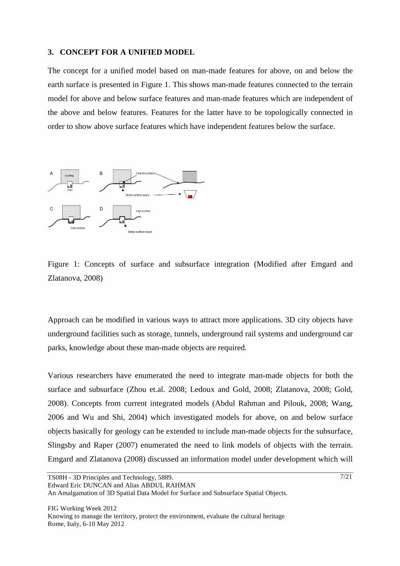
3. CONCEPT FOR A UNIFIED MODEL The concept for a unified model based on man-made features for above, on and below the
earth surface is presented in Figure 1. This shows man-made features connected to the terrain
model for above and below surface features and man-made features which are independent of
the above and below features. Features for the latter have to be topologically connected in
order to show above surface features which have independent features below the surface.
Figure 1: Concepts of surface and subsurface integration (Modified after Emgard and
Zlatanova, 2008)
Approach can be modified in various ways to attract more applications. 3D city objects have
underground facilities such as storage, tunnels, underground rail systems and underground car
parks, knowledge about these man-made objects are required.
Various researchers have enumerated the need to integrate man-made objects for both the
surface and subsurface (Zhou et.al. 2008; Ledoux and Gold, 2008; Zlatanova, 2008; Gold,
2008). Concepts from current integrated models (Abdul Rahman and Pilouk, 2008; Wang,
2006 and Wu and Shi, 2004) which investigated models for above, on and below surface
objects basically for geology can be extended to include man-made objects for the subsurface,
Slingsby and Raper (2007) enumerated the need to link models of objects with the terrain.
Emgard and Zlatanova (2008) discussed an information model under development which will
TS08H - 3D Principles and Technology, 5889. Edward Eric DUNCAN and Alias ABDUL RAHMAN An Amalgamation of 3D Spatial Data Model for Surface and Subsurface Spatial Objects. FIG Working Week 2012 Knowing to manage the territory, protect the environment, evaluate the cultural heritage Rome, Italy, 6-10 May 2012
8/21
integrate features above, on and below the surface into a common semantic and geometric
model by representing two alternatives in a conceptual model. Some of these concepts will be
adopted and modified in this research.
Most modern cities have underground rail systems or tunnels or utility lines. Current city
models are integration of above and on surface applications. Researchers have been trying to
bridge the gap between 2D, 2.5D and 3D GIS for surface objects but this has to be enhanced
by looking for the ‘missing link’ between surface and subsurface 3D models for man-made
objects and not for geosciences applications alone. In an urban city model with underground
facilities what if disaster strikes underground? What evacuation plans can be put in place?
What safe exits can be modelled? How will this affect the surrounding buildings? How will
the city authorities be able to indicate precisely where it occurred? City planners should be
able to locate all buildings with underground facilities, hence the need to model surface and
subsurface man-made objects.
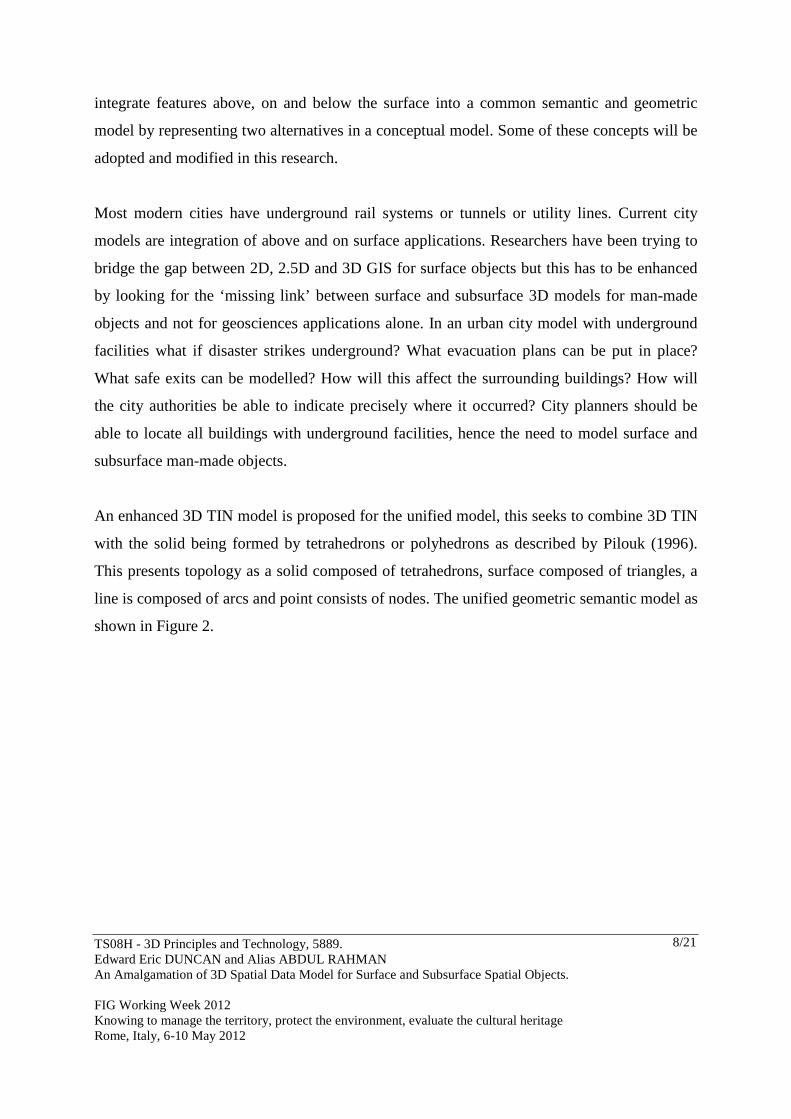
An enhanced 3D TIN model is proposed for the unified model, this seeks to combine 3D TIN
with the solid being formed by tetrahedrons or polyhedrons as described by Pilouk (1996).
This presents topology as a solid composed of tetrahedrons, surface composed of triangles, a
line is composed of arcs and point consists of nodes. The unified geometric semantic model as
shown in Figure 2.
TS08H - 3D Principles and Technology, 5889. Edward Eric DUNCAN and Alias ABDUL RAHMAN An Amalgamation of 3D Spatial Data Model for Surface and Subsurface Spatial Objects. FIG Working Week 2012 Knowing to manage the territory, protect the environment, evaluate the cultural heritage Rome, Italy, 6-10 May 2012
9/21
Figure 2. 3D Object Oriented Model (3DOOM)
Implicit geometry will be used to form the nodes with appropriate identifiers, the line
identifier will have a beginning node and an ending node with the topological relationship of
is on, is in, point and solid, line and solid, line and surface, point and surface being used to
form the relationship for the unified model. The TEN is formed by four nodes, six lines and
four triangles, to form solids for both the surface and subsurface.
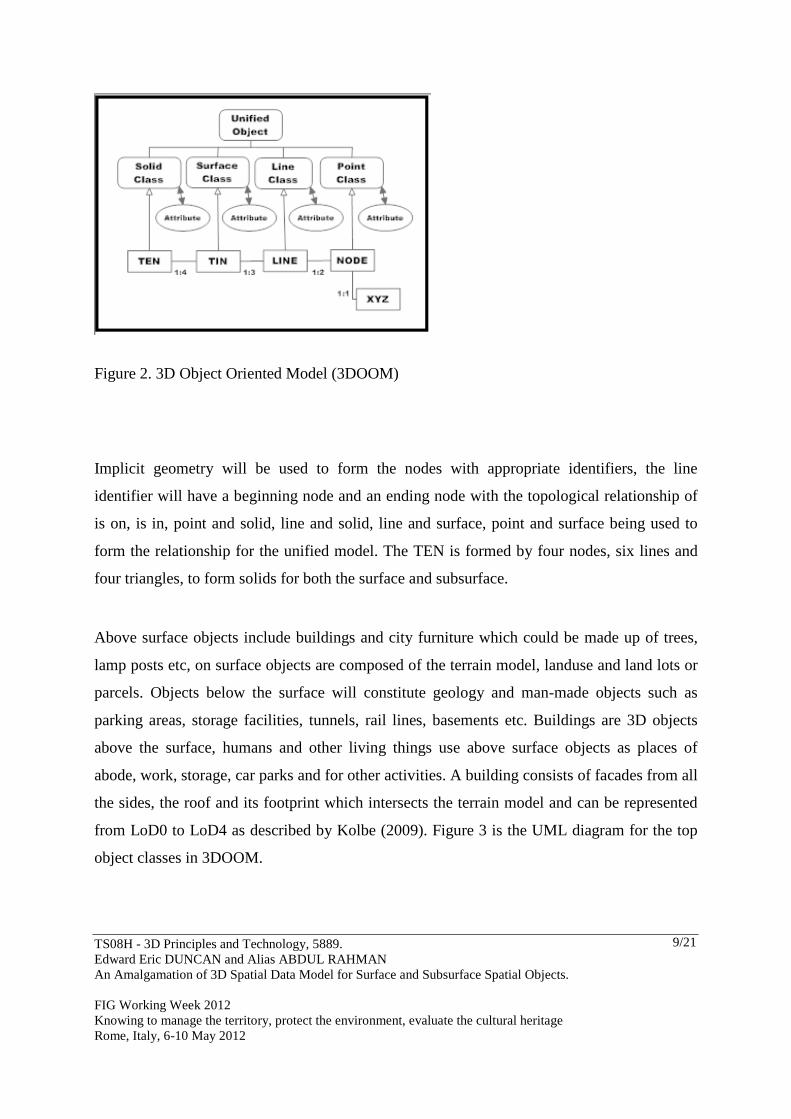
Above surface objects include buildings and city furniture which could be made up of trees,
lamp posts etc, on surface objects are composed of the terrain model, landuse and land lots or
parcels. Objects below the surface will constitute geology and man-made objects such as
parking areas, storage facilities, tunnels, rail lines, basements etc. Buildings are 3D objects
above the surface, humans and other living things use above surface objects as places of
abode, work, storage, car parks and for other activities. A building consists of facades from all
the sides, the roof and its footprint which intersects the terrain model and can be represented
from LoD0 to LoD4 as described by Kolbe (2009). Figure 3 is the UML diagram for the top
object classes in 3DOOM.
TS08H - 3D Principles and Technology, 5889. Edward Eric DUNCAN and Alias ABDUL RAHMAN An Amalgamation of 3D Spatial Data Model for Surface and Subsurface Spatial Objects. FIG Working Week 2012 Knowing to manage the territory, protect the environment, evaluate the cultural heritage Rome, Italy, 6-10 May 2012
10/21
Figure 3. A UML diagram for the top classes in 3DOOM
According to Emgard and Zlatanova (2007) city furniture refers to city lampposts, traffic
indicators, bus stops, large floral decors, benches, telephone booths, fences, advertisement
signs which are basically man-made. Below surface objects are man-made open spaces below
the earth’s terrain which may be extended basements, tunnels, railway tunnels and stations,
shops, parking lots, underground storage areas, mine shafts, drives and stopes.
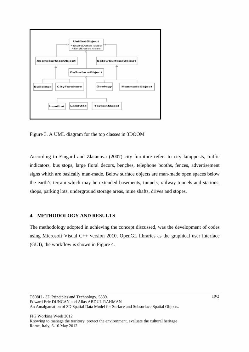
4. METHODOLOGY AND RESULTS The methodology adopted in achieving the concept discussed, was the development of codes
using Microsoft Visual C++ version 2010, OpenGL libraries as the graphical user interface
(GUI), the workflow is shown in Figure 4.
TS08H - 3D Principles and Technology, 5889. Edward Eric DUNCAN and Alias ABDUL RAHMAN An Amalgamation of 3D Spatial Data Model for Surface and Subsurface Spatial Objects. FIG Working Week 2012 Knowing to manage the territory, protect the environment, evaluate the cultural heritage Rome, Italy, 6-10 May 2012
11/21
Figure 4 Workflow for the unified model
The unified model was generated using implicit geometry from Computer Aided Design
(CAD) data into a process algorithm from which class containers were built as a dynamic link
library (DLL) and interfaced using visual c++ codes and graphic libraries for the display after
colour texturing.
4.1 Results and Discussions
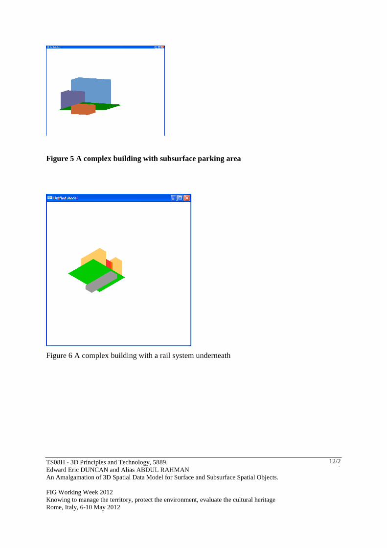
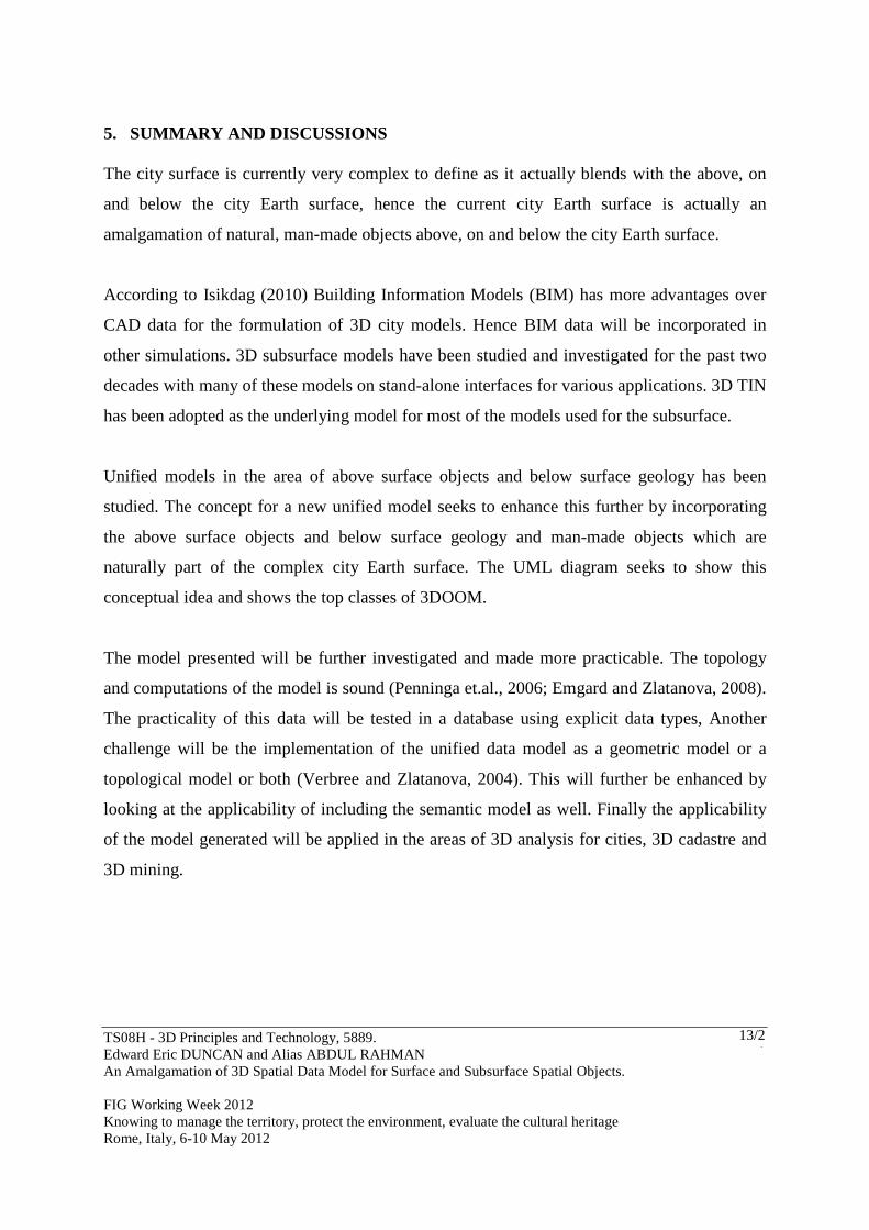
The unified model for two complex man-made constructions are shown in LoD 1. Figure 5 is
where a complex building with an underground parking area has been modelled using implicit
geometry. Figure 6 depicts a complex building with a road under the building and a below
subsurface man-made construction such as a rail system.
TS08H - 3D Principles and Technology, 5889. Edward Eric DUNCAN and Alias ABDUL RAHMAN An Amalgamation of 3D Spatial Data Model for Surface and Subsurface Spatial Objects. FIG Working Week 2012 Knowing to manage the territory, protect the environment, evaluate the cultural heritage Rome, Italy, 6-10 May 2012
12/21
Figure 5 A complex building with subsurface parking area
Figure 6 A complex building with a rail system underneath
TS08H - 3D Principles and Technology, 5889. Edward Eric DUNCAN and Alias ABDUL RAHMAN An Amalgamation of 3D Spatial Data Model for Surface and Subsurface Spatial Objects. FIG Working Week 2012 Knowing to manage the territory, protect the environment, evaluate the cultural heritage Rome, Italy, 6-10 May 2012
13/21
5. SUMMARY AND DISCUSSIONS The city surface is currently very complex to define as it actually blends with the above, on
and below the city Earth surface, hence the current city Earth surface is actually an
amalgamation of natural, man-made objects above, on and below the city Earth surface.
According to Isikdag (2010) Building Information Models (BIM) has more advantages over
CAD data for the formulation of 3D city models. Hence BIM data will be incorporated in
other simulations. 3D subsurface models have been studied and investigated for the past two
decades with many of these models on stand-alone interfaces for various applications. 3D TIN
has been adopted as the underlying model for most of the models used for the subsurface.
Unified models in the area of above surface objects and below surface geology has been
studied. The concept for a new unified model seeks to enhance this further by incorporating
the above surface objects and below surface geology and man-made objects which are
naturally part of the complex city Earth surface. The UML diagram seeks to show this
conceptual idea and shows the top classes of 3DOOM.
The model presented will be further investigated and made more practicable. The topology
and computations of the model is sound (Penninga et.al., 2006; Emgard and Zlatanova, 2008).
The practicality of this data will be tested in a database using explicit data types, Another
challenge will be the implementation of the unified data model as a geometric model or a
topological model or both (Verbree and Zlatanova, 2004). This will further be enhanced by
looking at the applicability of including the semantic model as well. Finally the applicability
of the model generated will be applied in the areas of 3D analysis for cities, 3D cadastre and
3D mining.
TS08H - 3D Principles and Technology, 5889. Edward Eric DUNCAN and Alias ABDUL RAHMAN An Amalgamation of 3D Spatial Data Model for Surface and Subsurface Spatial Objects. FIG Working Week 2012 Knowing to manage the territory, protect the environment, evaluate the cultural heritage Rome, Italy, 6-10 May 2012
14/21
6. CONCLUDING REMARKS AND FUTURE DIRECTIONS An in-depth review of current surface and subsurface models showed that the concept of 3D
FDS has been enhanced in various applications for 3D GIS with 3D TIN being adopted or
used in a hybrid model for most applications for the city Earth space.
The 3DOOM will be made practicable in a database using Oracle 11g. The UML top class
hierarchy has been developed, the subclasses will be developed to show the development and
implementation stages for the proposed unified model.
The city surface is currently very complex to define as it actually blends with the above, on
and below the city Earth surface, hence the current city Earth surface is actually an
amalgamation of natural, man-made objects above, on and below the city Earth surface and a
detailed knowledge for such man-made objects are required by city planners, engineers and
architects.
3D TIN has been applied for most research involving above, on and below feature objects and
the enhancement of this model in order to finally realise a functional 3D GIS platform should
be intensified.
Unified models in the area of above surface objects and below surface geology has been
studied. The concept for a new unified model seeks to enhance this further by incorporating
the above surface objects and below surface geology and man-made objects which are
naturally part of the complex city Earth surface. The UML diagram seeks to show this
conceptual idea and shows the top classes of 3DOOM.
Current integration techniques for the surface and subsurface objects are related to geology,
geotechnical and hydrogeology considerations, the addition of man-made features at the
TS08H - 3D Principles and Technology, 5889. Edward Eric DUNCAN and Alias ABDUL RAHMAN An Amalgamation of 3D Spatial Data Model for Surface and Subsurface Spatial Objects. FIG Working Week 2012 Knowing to manage the territory, protect the environment, evaluate the cultural heritage Rome, Italy, 6-10 May 2012
15/21
subsurface will complete the complexity of the city Earth space for above, on and below the
terrain surface to address the effective management of most cities. The algorithm for the
unified model if adopted will make information readily available to city authorities and help
avert disasters should they occur.
6.1 Future Directions
The unified model will be improved in the areas of 3D topology and 3D analysis. Real
textures to show the combination of LoD 3 for above surface and LoD 4 for below surface
objects is on-going. An algorithm to fully integrate the above framework in a database will be
part of the next phase of this research. The automatic integration of BIM data into 3D GIS
will be considered as part of the next phase.
Finally the applicability of the model generated will be applied in the areas of 3D analysis for
3D buildings, 3D cadastre in city modelling.
Acknowledgements
The Authors wish to acknowledge the support of the Ministry of Higher Education (MOHE)
and Universiti Teknologi Malaysia (UTM) and the Research Management Centre (RMC)
[Vote No. Q.J130000.7127.04J90] of UTM for providing the research university grant scheme
for this research. The University of Mines and Technology (UMaT) for granting study leave
to the researcher.
REFERENCES References from Journals: Apel, M. 2006. From 3D Geomodelling Systems Towards 3D Geoscience Information Systems: Data Model, Query Functionality, And Data Management. Computers & Geosciences, v. 32, iss. 2, pp. 222-229.
TS08H - 3D Principles and Technology, 5889. Edward Eric DUNCAN and Alias ABDUL RAHMAN An Amalgamation of 3D Spatial Data Model for Surface and Subsurface Spatial Objects. FIG Working Week 2012 Knowing to manage the territory, protect the environment, evaluate the cultural heritage Rome, Italy, 6-10 May 2012
16/21
Chen X. X and Wu L. X., 2003,Integral Real-3D Spatial Modelling For Subsurface Engineering And Geological Body Based On GTP Model. Geography And Geo-information Science, 19(6) Chen, H. H, and Huang, T. S., 1998. A Survey of Construction and Manipulation of Octree. CVGIP 43, pp.409-431. Cheng, P. G. and Gong, J. Y., 2001. Design of Three-Dimensional Spatial Data Model and Its Data Structure in Geological Exploration Engineering. Acta Geodaetica et Cartographica Sinica 30 1, pp.74-81. (in Chinese) Coors, V., 2003, 3D-GIS in Networking Environments, Computer, Environments and Urban Systems, Vol. 27/4, Special Issue 3D Cadastre, pp 345 – 357. Dai, W. J. and Zou, Z. R., 2001. Study of the Volume-Based 3-Dimensional GIS Data Model. Mine Surveying (1), pp.20-22. (in Chinese) Gabriel Courrioux, Stephane Nullans, Antonio Guillen, Jean Daniel Boissonnat, Philippe Repusseau, Xavier Renaud and Muriel Thibaut, 2001. 3D Volumetric Modelling Of Cadomian Terranes (Northern Brittany France): An Automatic Method Using Voronoi Diagrams. Tectonophysics. 331, pp.181-196. Ledoux, H. and Gold, C. M. 2008, Modelling Three-dimensional Geoscientific Fields with Voronoi Diagram and its Dual. Int. J. of Geographical Information Science. Vol. 22. Nos 4 – 5, April – May 2008, 547 – 574. Li, R 1994 Data Structures and Application Issues in 3-D Geographic Information Systems. Geomatica. Vol. 48, No. 3, pp 209-224. Penninga, F. and Oosterom, P. J. M. 2008, A Simplicial Complex-Based DBMS Approach to 3D Topographic Data Modelling, Int J. Geographic Information Science, Vol. 22. Nos 6-7, June-July 2008, 751-779. Pilouk, M., Tempili, K. amd Molenaar, M., 1994, A Tetrahedron-Based 3D Vector Data Model For Geoinformation. Advanced Geographic Data Modelling, 40, 129-140. Shi, W. Z., 1996. A Hybrid Model For 3D GIS. Geoinformatics 1, pp.400-409. Shi, W. Z., 2000. Development Of A Hybrid Model For Three-Dimensional GIS. Geo-Spatial Information Science 3 2, pp.6-12. Simon, W. H., 1994. 3D Geosciences Modeling: Computer Techniques for Geological Characterization. Springer-Verlag.
TS08H - 3D Principles and Technology, 5889. Edward Eric DUNCAN and Alias ABDUL RAHMAN An Amalgamation of 3D Spatial Data Model for Surface and Subsurface Spatial Objects. FIG Working Week 2012 Knowing to manage the territory, protect the environment, evaluate the cultural heritage Rome, Italy, 6-10 May 2012
17/21
Tipper, J. C., 1977, A Method And FORTRAN Program For The Computerized Reconstruction Of Three-Dimensional Objects From Serial Sections. Computers & Geosciences 3 4, pp 579-599 Tsai, Victor JD, 1993. Delaunay Triangulation In TIN Creation: An Overview And A Linear-Time Algorithm. Int. J. Geographical Information Systems 7 6, pp.501-524 Wu, L and Shi, W. 2004. GTP-Based Integral Real 3D Spatial Model for Engineering Excavation GIS (E2 GIS), Geo-spatial Information Science (Quarterly) 7(3), pp 123 – 128. Wu, L. X., Shi, W. Z. and Christopher, G. M., 2003. Spatial Modelling Technologies for 3D GIS and 3D GMS. Geography and Geo-information Sciences 19 1, pp.5-11. Zhang, Y. and Bai, S. W., 2001. An Approach of 3D Stratum Modeling Based on Tri-Prism Volume Elements. Journal of Image and Graphics 6 3, pp.285-290. References from Books: Abdul-Rahman, A. and Pilouk, M, 2008. Spatial Data Modelling for 3D GIS, published by Springer Berlin-Heidelberg, New York, 289pp. Breunig, M. and Zlatanova, S. 2006. 3D Geo-DBMS. In Zlatanova, S. And Prosperi, D. (eds.), Large-scale 3D Data Integration-Challenges and Opportunities: 87-115. London: Taylor and Francis.
Emgard, L and Zlatanova, S (2007), “Implementation Alternatives For An Integrated 3D Information Model published by Springer in Advances in 3D GeoInformation Systems, pp 313-329. Emgard, L. and S. Zlatanova, 2008, Design Of An Integrated 3D Information Model, in Coors, Rumor, Fendel and Zlatanova (eds.) Urban and Regional data Management, UDMS Annual 2008, Taylor and Francis Group, London, pp. 143-156. Fisher, TR and Wales, RQ, 1991. Three-Dimensional solid modelling of geological objects using non-uniform rational B-splines (NURBS). In Three Dimensional Modelling with Geoscientific Information Systems, edited by Turner, A.K. (Kluwer, Dordrecht), pp. 85–105. Gold, C., 2008, Chapter 25 Working Group III-Modelling-Position paper on Modelling 3D Geo-Information. In Advances in 3D Geoinformation Systems, Eds. P. Van Oosterom, S. Zlatanova, F. Penninga, E. Fendel published by Springer Berlin-Heidelberg, New York, pp 429-435. Gong, J. Y., Cheng P. G., Liu R., Li D. J. and Liu S. H., 2002. Study on 3D Modeling and Visualization in Geological Exploration Engineering. In Proc. ISPRS Commission II Sym. On Integrated System For Spatial Data Production, Custodian And Decision Support, pp.133-138.
TS08H - 3D Principles and Technology, 5889. Edward Eric DUNCAN and Alias ABDUL RAHMAN An Amalgamation of 3D Spatial Data Model for Surface and Subsurface Spatial Objects. FIG Working Week 2012 Knowing to manage the territory, protect the environment, evaluate the cultural heritage Rome, Italy, 6-10 May 2012
18/21
Kolbe, T. H. 2009, Representing and Exchanging 3D City Models with CityGML, Lee, J., Zlatanova, S. (Eds), 3D Geoinformation Sciences, Springer Verlag, Berlin Heidelberg. Lattuada, R. 2006. Three-dimensional representations and data structures in GIS and AEC. In: Zlatanova, S. & Prosperi, D. (eds.), Large-scale 3D data integration-Challenges and Opportunities: 57-86. London: Taylor and Francis. Raper, J. (ed.).1989. Three Dimensional Applications In Geographic Information Systems. Taylor & Francis Ltd., London, 189 pp. 1989
Slingsby, A. and Raper, J. 2007. Navigable Space in 3D City Models for Pedestrains, published by Springer in Advances in 3D GeoInformation Systems, pp 49-64. Zlatanova, S., 2008, Chapter 24 Working Group-Acquisition-Position Paper-Data Collection and 3D reconstruction, In Advances in 3D Geoinformation Systems, (Eds). P. Van Oosterom, S. Zlatanova, F. Penninga, E. Fendel published by Springer Berlin-Heidelberg, New York, pp425-428. References from Other Literature: Abdul-Rahman, A. (2000) The Design and Implementation of a two and Three dimensional Triangular Network based GIS, PhD Thesis, University of Glasgow, U. K., 204pp. Barry Joe, 1991. Construction Of 3D Delaunay Triangulations Using Local Transformations. Computer Aided Geometric Design 8, pp.123-142
Breunig, M., Bode, T. and Cremers, A., 1994. Implementation of Elementary Geometric Database Operations for a 3D GIS. In: Proc. Of the 6th Int. Symp. On Spatial Data Handling. Breunig, M., Cremers, A., Muller, W. and Siebeck, J., 2001. New Methods for Topological Clustering and Spatial Access in Object-oriented 3D databases. In: Proc. Of the 9th ACM Int. Symp. On Advances in Geographic Information Systems. Charlton, J., Horne, M. and Giddings, B. 2008, A Holistic Approach to Urban Design Using 3D Computer Modelling, Design and Decision Support Systems, The Netherlands.
Hack, R., Orlic, B., Ozmutlu, S., Zhu, S. and Rengers, N. 2006. Three And More Dimensional Modelling In Geo-Engineering. Bulletin of Engineering Geology and the Environment 65(2): 143-153. Horne, M., Thompson, E. M. and Podevyn, M. 2007, An Overview of Virtual City Modelling: Emerging Organisational Issues... CUPUM07 10th International Conference on Computers in Urban Planning and urban Management, Iguassau Falls, Brazil.
TS08H - 3D Principles and Technology, 5889. Edward Eric DUNCAN and Alias ABDUL RAHMAN An Amalgamation of 3D Spatial Data Model for Surface and Subsurface Spatial Objects. FIG Working Week 2012 Knowing to manage the territory, protect the environment, evaluate the cultural heritage Rome, Italy, 6-10 May 2012
19/21
Isikdag, U. 2010, Building Information Management and 3D City Modeling, 3D City Modelling Tutorial, 23rd – 27th September, 2010, UTM, Malaysia. Koshak, N. and Flemming, U. 2002, Object Oriented Data Modelling and Warehousing to Support Urban Design. 6th International Conference and Decision Support Systems in Architecture and Planning, July 7 – 10, 2002. Ellecom, The Netherlands. Molenaar, M. 1990, A Formal Data Structure for 3D Vector Maps, Proceedings of EGIS’90 Vol.2, Amsterdam, The Netherlands, pp 770 – 781. Penninga, F., van Oosterom, P. and Kazar, B., 2006, A Tetrahedronized Irregular Network Based DBMS Approach for 3D Topographic Data Modelling. Progress in Spatial Data Handling, 12th International Symposium on Spatial Data Handling, 581 – 598 Springer Berlin Heidelberg 2006. Pigot, S., 1992 A Topological Model for a 3-D Spatial Information Systems, Proc. 10th International Symposium on Computer Assisted Cartography (AUTOCARTO 10), Technical Papers, ACSM-ASPRS, Annual Convention, Vol. 6, Baltimore, Maryland, USA, pp 369-391.
Pilouk, M., 1996, Integrated Modelling for 3D GIS. PhD dissertation, ITC Publications No 40, The Netherlands, 200pp, Podevyn, M., Horne, M., Fisher, P. and Thompson, E. M., 2008, Global Visualisation Engines – Issues for Urban Landscape Planning Participation Processes, Digital Design in landscape Architecture Proceedings, Anhalt University of Applied Sciences
Raper, J. and Maguire, D.J. 1992. Design Models And Functionality In GIS. Computers and Geosciences 18: 387-394. SparxSystems, 2007, Enterprise Architect Version 7.0 User Guide. Ross, L., Bolling, J., Dollner, J. and Kleinschmit, B.., 2009. Enhancing 3D City Models with Heterogeneous Spatial Information: Towards 3D land Information Systems, Sester, M., Bernard, L and paelke, V (Eds) Advances in GIScience, Proceedings of the 12th AGILE Hannover. Sapidis Nickolas and Renato Perucchio, 1991. Delaunay Triangulation Of Arbitrarily Shaped Planar Domains. Computer Aided Geometric Design 8, pp.421-437. Thompson, E. M. And Horne, M., 2010, 3D-GIS Integration for Virtual NewcastleGateshead, 28th eCAADe Conference, Future Cities, September 15-18, 2010, Zurich-Switzerland, pp 767 -775.
Tsai, Victor JD, and Alan P. Vonderohe 1993. Delaunay Tetrahedral Data Modeling For 3D GIS Application. In Proceedings of GIS/LIS’93, pp. 671-680.
TS08H - 3D Principles and Technology, 5889. Edward Eric DUNCAN and Alias ABDUL RAHMAN An Amalgamation of 3D Spatial Data Model for Surface and Subsurface Spatial Objects. FIG Working Week 2012 Knowing to manage the territory, protect the environment, evaluate the cultural heritage Rome, Italy, 6-10 May 2012
20/21
Verbree, E. and Zlatanova, S. 2004, 3D-modelling with respect to boundary representations within geo-DBMS, GISt Report No. 29, Delft, 2005, 30pp. Wang, Y. (2006) 3D GIS Spatial Modelling for City Surface and Subsurface Integration, published by IEEE, pp 1511 – 1518. Zhou, I., Lu, G., Sheng, Y., Xu. H., and Wang, H., (2008). A 3d GIS’s Spatial Data Model Based on Cell Complex. The International Archives of the Photogrammetry, Remote Sensing and Spatial Information Sciences. Vol. XXXVII Part B2, Beijing, pp 905 – 908. Zlatanova, S., Abdul Rahman, A and Pilouk, M (2002) “3D GIS: Current Status and Perspectives” ISPRS Commission IV, WGIV/1, pp1-6. Zlatanova, S., Abdul Rahman, A and Pilouk, M (2002) “3D GIS: Current Status and Perspectives” ISPRS Commission IV, WGIV/1, pp1-6. Zlatanova, S. 2000. 3D GIS for Urban Development, PhD Thesis, ITC Dissertation Series No 69. The International Institute for Aerospace Survey and Earth Sciences, The Netherlands.
BIOGRAPHICAL NOTES E. E. Duncan, holds a MSc degree in Topographic Science (Surveying) from Glasgow University in the UK and a BSc degree in Geodetic Engineering from the Kwame Nkrumah University of Science and Technology in Ghana. He is also a Professional member of the Ghana Institution of Surveyors (MGhIS) and a lecturer (On Study leave) at the University of Mines and Technology in Ghana. He is currently a PhD researcher with the 3D GIS group of the Faculty of Geoinformation and Real Estate at the Universiti Teknologi Malaysia (UTM) in Malaysia. His current research interests include 3D spatial models for surface and subsurface objects. Alias Abdul Rahman is a Professor at the Department of Geoinformatics and Dean of the Faculty of Geoinformation and Real Estate, Universiti Teknologi Malaysia (UTM), Skudai, Johor. He received a degree in Surveying and Mapping Sciences from North East London Polytechnic, England, UK in 1987, Postgraduate Diploma in GIS from ITC, Netherlands, and MSc in GIS also from ITC, Netherlands. In 2000, he received his PhD degree from the University of Glasgow, Scotland, U.K. Currently he serves as Chair for ISPRS Commission II/5 from 2008 – 2012 on Multidimensional GIS and Mobile Data Model.

TS08H - 3D Principles and Technology, 5889. Edward Eric DUNCAN and Alias ABDUL RAHMAN An Amalgamation of 3D Spatial Data Model for Surface and Subsurface Spatial Objects. FIG Working Week 2012 Knowing to manage the territory, protect the environment, evaluate the cultural heritage Rome, Italy, 6-10 May 2012
21/21
CONTACTS Edward Eric DUNCAN and Alias ABDUL RAHMAN University Technology Malaysia Faculty of Geoinformation and Real Estate, 81310, Skudai, Johor Bahru MALAYSIA Tel. +060177639038 / 06137490452 Fax +(6)075566163 Email:[email protected] / [email protected] and [email protected] Web site: www.fght.utm.my


![Higher Frame in Spatial Films [3D]](https://img.pdfslide.us/doc/110x75/587f5dac1a28ab0d378b7a5b/higher-frame-in-spatial-films-3d.jpg)