Embed Size (px)
Citation preview
AMS Washington ForumFederal Panel
Michael H. Freilich4 April 2013
Suomi NPP VIIRSVisible Composite
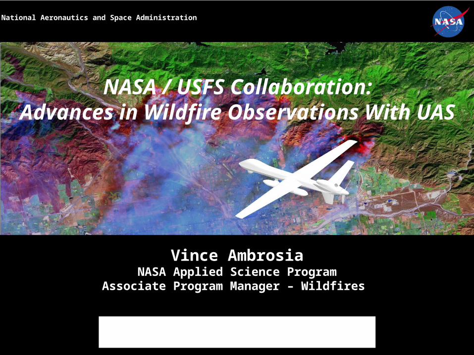
NASA / USFS Collaboration:Advances in Wildfire Observations With
UAS
Vince AmbrosiaNASA Applied Science Program
Associate Program Manager – Wildfires
Applications of UAS to Land and Natural Resource ManagementWorkshop at Argonne National Laboratory, IL.
16-17 July 2014
National Aeronautics and Space Administration

NASA Airborne Wildfire Support Heritage
1970’s – early 2000’s• NASA-ARC collaboration with CA to support
disaster events with “as-needed” / available airborne sensor data (agreements date to mid-1970’s).
• NASA Earth Science Research Aircraft with thermal sensing systems supported over 100 fires in period with digital imagery on fire locations:
• NASA C130• Supported Oakland Hills Fire
• Supported Yellowstone NP complex
• NASA U2 / ER-2• Supported numerous CA fires
• Yellowstone NP complex
2003 - Current
WRAP: Wildfire Research and Applications PartnershipCollaboration to evaluate, test, mature and implement emerging technologies, instrumentation, and models into operational utility, improving capabilities to manage wildfires.
Focus on Partner needs:
» Platforms (UAS) for observations in hazardous fire environs.
» Improved sensor systems.» Time-critical, real-time data
collection and delivery.» Adaptable visualization system for
wildfire incident assessments.
Research to Operations: Partnership is Key
Industry
Academia

Possible UAS Fire Applications
UAS For Natural Resource Assessments WorkshopCSUMB 2005

• Owns and operates 27 aircraft and helicopters
• Contracts with over 800 aircraft and helicopters annually
• Missions Include:
– Fire surveillance
– Aerial reconnaissance
– Air Attack
– Delivery of smoke jumpers
– Firefighter and cargo transport
– Aerial delivery of retardant and water
– Natural resource management
– Research
Forest Service Aviation
CAN UAS AUGMENT THESE AVIATION ASSETS?

Two-Track Approach to Evaluating UAS
Small Platforms
Large Platforms
STRATEGIC
TACTICAL

• Augment, NOT replace, manned aircraft assets!!• Work with partners to identify niche applications that are underserved
by current technology;• Keep the approach simple; work on doing one thing well before adding
additional capabilities;• Provide unified systems that are affordable and have compatible
operations;
Forest Service UAS Strategy

5 nm radius
TANKER ORBIT ALTITUDE PLUS 500’
ATGS ALT. PLUS 1000’2500 AGL
500’ AGL
TANKER PATTERN 1000’ AGL MANEUVERING ALTITUDE
7nm NOCOM HOLDING RING
12nm initialContact ring
After obtaining a COA, there are additional challenges to using UAS on wildfires…
Fire Traffic Area (FTA) Environment
Lat / Long

Demonstrating Strategic Assets: NASA Ikhana UAS
NASA Ikhana with Sensor Pod under-wing mount
NASA “Ikhana” UAVThe Ikhana is a derivative of the Predator B (MQ-9) “Reaper” UAV, designed as a NASA science and research platform. “Ikhana” is a Native American Choctaw-nation word meaning: “Intelligence, Conscience or Aware”.
Length: 36 feet,Wingspan: 66 feetOperations: ~50K ft; Endurance: ~24-hoursSpeed: 170-200 ktsPayload: 2400 lbs of instrumentsMax T/O weight: 10,500 poundsC&C and sensor telemetry: C-band (local) & Ku-band (global)
Autonomous Modular Sensor (AMS)

Autonomous Modular Scanner (AMS)
AMS Wildfire SensorTwo environmental enclosures (data disks & GPS; and power supplies & controllers)
Scan Head
Data System
Enclosure Band Wavelength m1 0.42 - 0.452 0.45 - 0.52 (TM1)3 0.52 - 0.60 (TM2)4 0.60 - 0.625 0.63 - 0.69 (TM3)6 0.69 - 0.757 0.76 - 0.90 (TM4)8 0.91 - 1.05 9 1.55 - 1.75 (TM5) (high gain)10 2.08 - 2.35 (TM7) (high gain)
11 3.60 - 3.79 (VIIRS M12) (high gain) 12 10.26 - 11.26 (VIIRS M15) (high gain)13 1.55 - 1.75 (TM5) (low gain)14 2.08 - 2.35 (TM7) (low gain)
15 3.60 - 3.79 (VIIRS M12) (low gain) 16 10.26 - 11.26 (VIIRS M15) (low gain)
Total Field of View: 42.5 or 85.9 degrees (selectable)IFOV: 1.25 mrad or 2.5mrad ( “ )Spatial Resolution: 3 – 50 meters (variable)

2006-2009 Western States Fire Mission
• NASA/USFS collaboration via Wildfire Research Applications Partnership (WRAP)
• Missions conducted using NASA Ikhana UAS
−Standard MQ-9 Predator B / Reaper
w/o “Skyball”;
• Mission Plan:− One LE mission/week
− 4-5 missions/summer
• Mission Durations:− ~20+ hours
• Flight Altitude Operations:− FL230 (23,000 feet MSL)
Results:• 22 missions• 58 Fires• Traversed 8 western states• ~180 operational hours in the National Airspace

Processing Architecture

On-Board Processing
• Develop useful fire spectral band combinations for different collection scenarios (day / night):
– DAY: b12 (10.26 -11.26 um), b9 (1.55- 1.75 um), b11 (3.60- 3.79
um) as R-G-B;
– NIGHT: b12 (10.26 -11.26 um) for night ops
• Develop R/T “hot-spot detect algorithm”:
– Modified CCRS algorithm:Fire = If b11 (3.60- 3.79 um) brightness temp > 3800 K; and b12
(10.26 -11.26 um) brightness temp > 2400 K; and b11 - b120 > 12K; and Band 7 (0.76 – 0.9um) < 0.22 (screen high reflectance commission errors).
• Develop R/T BAER visualization spectral band combinations:– b10 (2.08 – 2.35 um), b9 (1.55- 1.75 um), b7 (0.76 – 0.90 um) as
RGB
• Develop R/T post-fire, calibrated NBR algorithm data:b7 - b10 where, (b10 (2.08- 2.35 um); b7 (0.76 – 0.90
um))b7 + b10
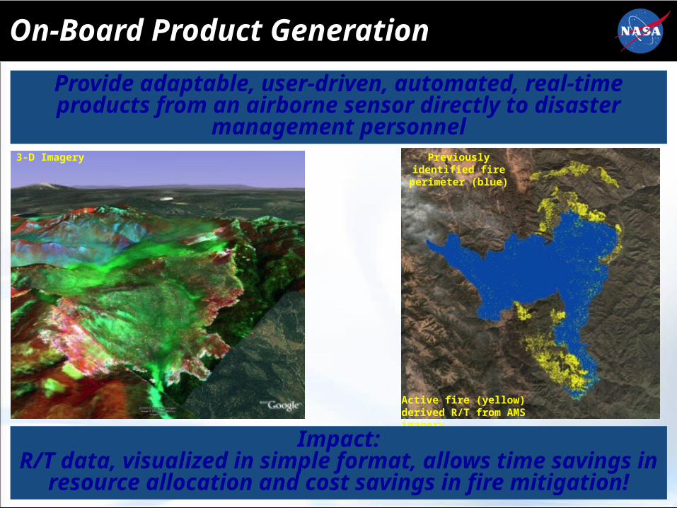
On-Board Product Generation
3-D Imagery Previously identified fire perimeter (blue)
Active fire (yellow) derived R/T from AMS imagery
Provide adaptable, user-driven, automated, real-time products from an airborne sensor directly to disaster
management personnel
Impact:R/T data, visualized in simple format, allows time savings in
resource allocation and cost savings in fire mitigation!
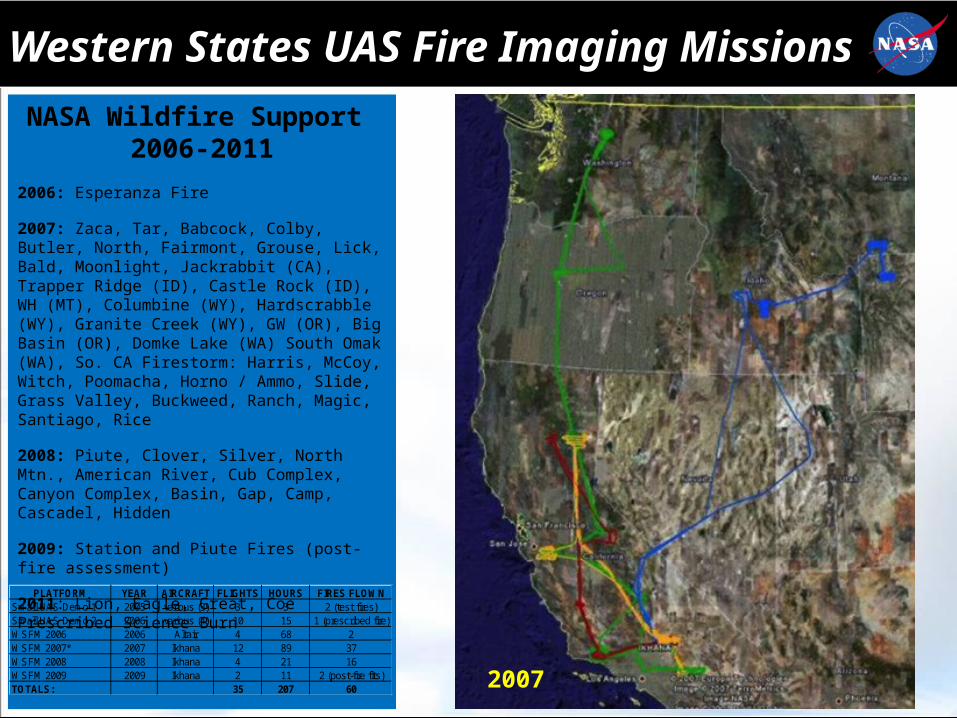
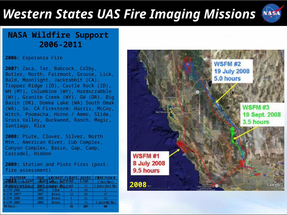
Western States UAS Fire Imaging Missions
NASA Wildfire Support 2006-2011
2006: Esperanza Fire
2007: Zaca, Tar, Babcock, Colby, Butler, North, Fairmont, Grouse, Lick, Bald, Moonlight, Jackrabbit (CA), Trapper Ridge (ID), Castle Rock (ID), WH (MT), Columbine (WY), Hardscrabble (WY), Granite Creek (WY), GW (OR), Big Basin (OR), Domke Lake (WA) South Omak (WA), So. CA Firestorm: Harris, McCoy, Witch, Poomacha, Horno / Ammo, Slide, Grass Valley, Buckweed, Ranch, Magic, Santiago, Rice
2008: Piute, Clover, Silver, North Mtn., American River, Cub Complex, Canyon Complex, Basin, Gap, Camp, Cascadel, Hidden
2009: Station and Piute Fires (post-fire assessment)
2011: Lion, Eagle, Great, Coe Prescribed Science Burn
PLATFORM YEAR AIRCRAFT FLIGHTS HOURS FIRES FLOWNSmall UAS Demo 1 2005 various (3) 3 3 2 (test fires)Small UAS Demo 2 2006 various (4) 10 15 1 (prescribed fire)WSFM 2006 2006 Altair 4 68 2WSFM 2007* 2007 Ikhana 12 89 37WSFM 2008 2008 Ikhana 4 21 16WSFM 2009 2009 Ikhana 2 11 2 (post-fire flts)TOTALS: 35 207 60 2007
2008
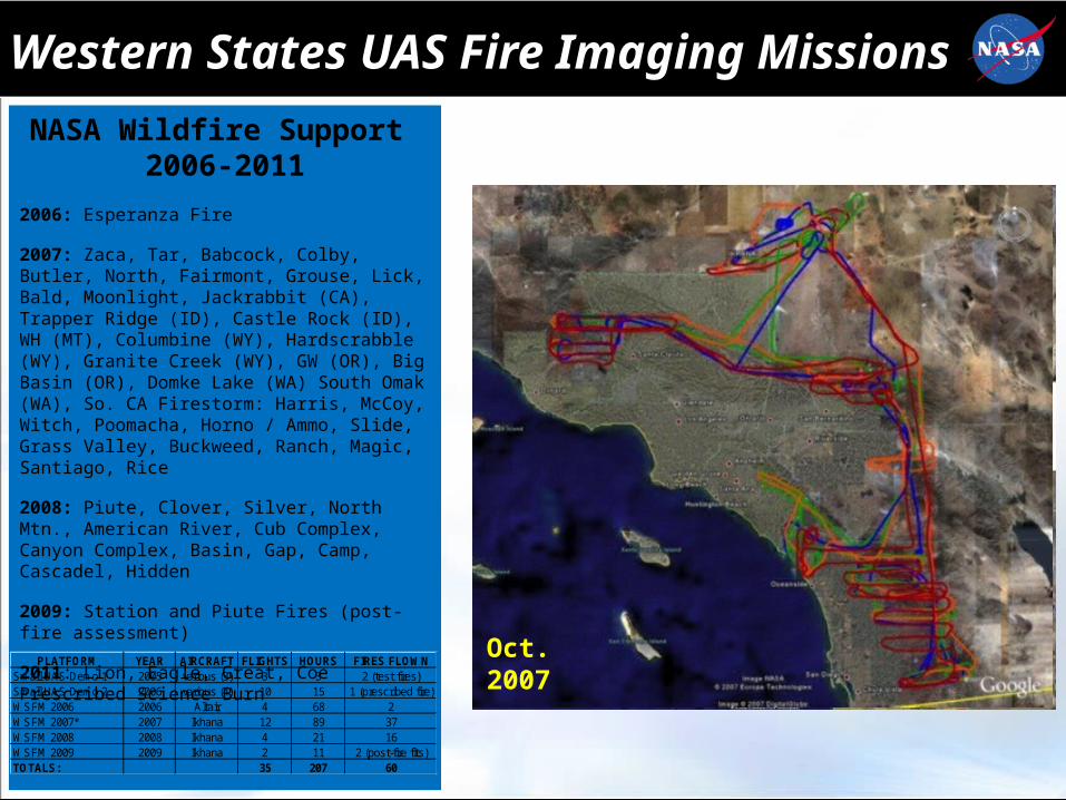
Western States UAS Fire Imaging Missions
Oct. 2007
NASA Wildfire Support 2006-2011
2006: Esperanza Fire
2007: Zaca, Tar, Babcock, Colby, Butler, North, Fairmont, Grouse, Lick, Bald, Moonlight, Jackrabbit (CA), Trapper Ridge (ID), Castle Rock (ID), WH (MT), Columbine (WY), Hardscrabble (WY), Granite Creek (WY), GW (OR), Big Basin (OR), Domke Lake (WA) South Omak (WA), So. CA Firestorm: Harris, McCoy, Witch, Poomacha, Horno / Ammo, Slide, Grass Valley, Buckweed, Ranch, Magic, Santiago, Rice
2008: Piute, Clover, Silver, North Mtn., American River, Cub Complex, Canyon Complex, Basin, Gap, Camp, Cascadel, Hidden
2009: Station and Piute Fires (post-fire assessment)
2011: Lion, Eagle, Great, Coe Prescribed Science Burn
PLATFORM YEAR AIRCRAFT FLIGHTS HOURS FIRES FLOWNSmall UAS Demo 1 2005 various (3) 3 3 2 (test fires)Small UAS Demo 2 2006 various (4) 10 15 1 (prescribed fire)WSFM 2006 2006 Altair 4 68 2WSFM 2007* 2007 Ikhana 12 89 37WSFM 2008 2008 Ikhana 4 21 16WSFM 2009 2009 Ikhana 2 11 2 (post-fire flts)TOTALS: 35 207 60
2008
Western States UAS Fire Imaging Missions
NASA Wildfire Support 2006-2011
2006: Esperanza Fire
2007: Zaca, Tar, Babcock, Colby, Butler, North, Fairmont, Grouse, Lick, Bald, Moonlight, Jackrabbit (CA), Trapper Ridge (ID), Castle Rock (ID), WH (MT), Columbine (WY), Hardscrabble (WY), Granite Creek (WY), GW (OR), Big Basin (OR), Domke Lake (WA) South Omak (WA), So. CA Firestorm: Harris, McCoy, Witch, Poomacha, Horno / Ammo, Slide, Grass Valley, Buckweed, Ranch, Magic, Santiago, Rice
2008: Piute, Clover, Silver, North Mtn., American River, Cub Complex, Canyon Complex, Basin, Gap, Camp, Cascadel, Hidden
2009: Station and Piute Fires (post-fire assessment)
2011: Lion, Eagle, Great, Coe Prescribed Science Burn
PLATFORM YEAR AIRCRAFT FLIGHTS HOURS FIRES FLOWNSmall UAS Demo 1 2005 various (3) 3 3 2 (test fires)Small UAS Demo 2 2006 various (4) 10 15 1 (prescribed fire)WSFM 2006 2006 Altair 4 68 2WSFM 2007* 2007 Ikhana 12 89 37WSFM 2008 2008 Ikhana 4 21 16WSFM 2009 2009 Ikhana 2 11 2 (post-fire flts)TOTALS: 35 207 60
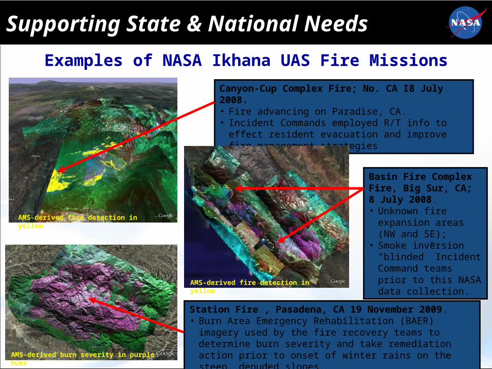
Supporting State & National Needs
Canyon-Cup Complex Fire; No. CA I8 July 2008. • Fire advancing on Paradise, CA.• Incident Commands employed R/T info to effect resident
evacuation and improve fire management strategies
Basin Fire Complex Fire, Big Sur, CA; 8 July 2008. • Unknown fire expansion
areas (NW and SE);• Smoke inversion
“blinded” Incident Command teams prior to this NASA data collection.
Station Fire , Pasadena, CA 19 November 2009. • Burn Area Emergency Rehabilitation (BAER) imagery used by
the fire recovery teams to determine burn severity and take remediation action prior to onset of winter rains on the steep, denuded slopes.
AMS-derived fire detection in yellow
AMS-derived fire detection in yellow
AMS-derived burn severity in purple hues
Examples of NASA Ikhana UAS Fire Missions

AMS Normalized Burn Ratio (NBR) and Landsat Burn Area Reflectance Class’n (BARC)
Post-Fire Rapid Burn Assessments
• Objective is to prepare a Burn Area Emergency Response plan within 10 days of fire containment
• Satellite and airborne remote sensing support rapid identification of areas posing high risk (erosion, mudslides, etc.) and high need for treatment.

NASA Ikhana
Right Information, to Right People, at the Right Time!!
Real-Time Info Direct to First Responders
Collaborative Decision Environment at San Diego County Emergency
Operations Center

Tactical UAS – Right Tool For Right Job
Tactical (sUAS)
The situations where tactical UAS can support wildfire observations:
Fireline Supervisors use to provide real-time photo / video and IR imagery in tactical situations;
Direct support to fireline operations / hot-shot crews;
Conditions where manned aircraft are undesirable (smoke, night, difficult terrain, etc.);
Fire support by sUAS is required immediately;
Ability to launch quickly;
Mop-Up Operations / Spot Fire
ScanEagle Support AK Fires, 2010
First UAS (LARP) Fire Effort, 1961
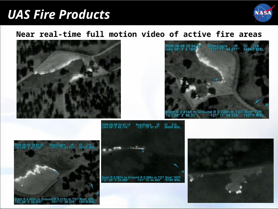
UAS Fire Products
Near real-time full motion video of active fire areas

Small UAS Demo / Evaluation Missions• Conducted primarily to assess
UAS for fire management objectives:
− Short/long endurance missions
− Incident intel and communications
• USFS role: – Evaluate entire system
– Report, develop guidance documentation
• UAS payloads and capabilities:– EO/IR video and mapping cameras
– Wx sensors
– Communications relay
– Software technologies to generate NRT geospatial products
– Aircraft modifications for nighttime ops
Tier II – LALE (RS-16)
NRT image mosaic product
Tier I – Small (Raven)
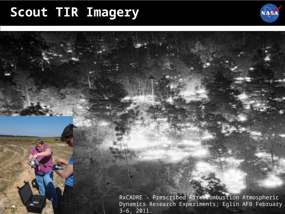
Scout TIR Imagery
RxCADRE – Prescribed Fire Combustion Atmospheric Dynamics Research Experiments; Eglin AFB February 3-6, 2011.
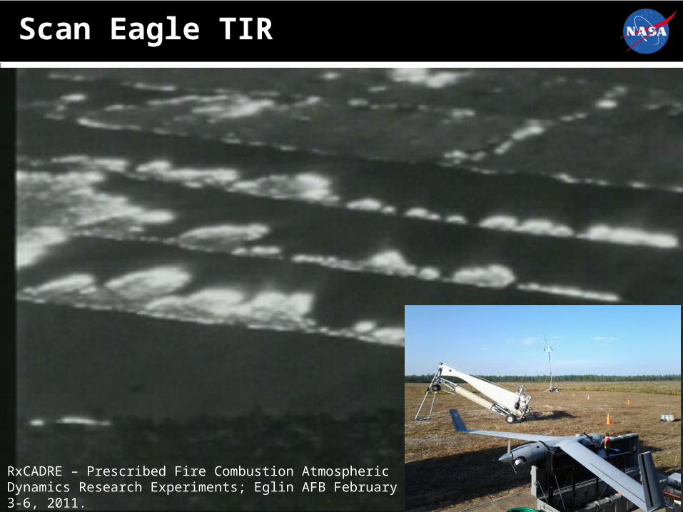
Scan Eagle TIR
RxCADRE – Prescribed Fire Combustion Atmospheric Dynamics Research Experiments; Eglin AFB February 3-6, 2011.
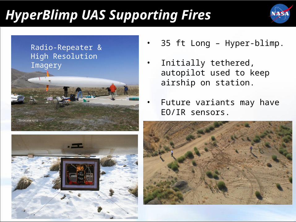
HyperBlimp UAS Supporting Fires
Radio-Repeater &High Resolution Imagery
• 35 ft Long – Hyper-blimp.
• Initially tethered, autopilot used to keep airship on station.
• Future variants may have EO/IR sensors.
• Integrating UAS into fire operations is complicated, but not impossible
• UAS augments manned aircraft capacity– Expands the “tool kit”
– Transfer of technologies
• It’s also about the mission objective, the sensor and related technologies– Sensor characteristics
– Data and products
– Communications; Delivery and dissemination of data/products
• UAS-derived data and intelligence can potentially increase the safety and effectiveness of firefighters
Points to Consider
Points to Consider
• Large UAS uses on wildfires will continue to be ad-hoc (CBP Support, etc.);
• sUAS are being evaluated, and in some cases operationalized in agencies (DOI-USGS);
• USFS UAS Advisory Group developing agency guidelines for UAS use on fire and other support efforts;
• Agencies exploring the “own / contract” tradeoff for UAS fire use;
• sUAS seen as augmentation to fire aircraft operations, supplementing rotorcraft ops / and dangerous conditions (night / smoky, etc.) use;
• As sUAS platforms are surplused from DoD to govt. agencies, there will be a push to utilize in disaster / wildfire support.
These technology adoptions will improve national wildfire decision support systems, resulting in
significant time-savings in intelligence delivery, and simplifying the analysis of the data!!


![Finnish, Suomi [Language 30]](https://img.pdfslide.us/doc/110x75/577d21801a28ab4e1e955dea/finnish-suomi-language-30.jpg)