Embed Size (px)
Citation preview

American History and the American Dream
Liberty as a human right is the main theme of American history. American history, then, is about the American Dream. The dream of finding freedom and opportunity to be who you are and become what you might be as a human being. This dream unites us as Americans and motivates others to immigrate to the United States of America. Not all have experienced the American Dream. Native Americans and enslaved African-Americans were denied this dream. Yet this powerful idea of liberty as a human right, written in the United States Constitution, has moved America slowly toward its ideal of liberty and justice for all.
HOW DID THE UNITED STATES OF AMERICA COME TO BE?

America – This term has two meanings: 1) the North and/ or South American continents, and 2) the area that became the United States of America. The context of the narrative indicates the meaning.
To understand the history of the United States of America, we have to know where we are. That
means we have to understand the geography of our nation first. History always begins with GEO (Earth)
GRAPHY (to describe), for as nature shapes the land, so the land shapes the people who inhabit the
land.

GEOGRAPHY OF THE UNITED STATES

This Land Is Your LandWords and Music by Woody Guthrie
This land is your land This land is my landFrom California to the New York island; From the red wood forest to the Gulf Stream waters This land was made for you and Me.As I was walking that ribbon of highway, I saw above me that endless skyway: I saw below me that golden valley: This land was made for you and me.I've roamed and rambled and I followed my footsteps To the sparkling sands of her diamond deserts; And all around me a voice was sounding: This land was made for you and me.When the sun came shining, and I was strolling, And the wheat fields waving and the dust clouds rolling, As the fog was lifting a voice was chanting: This land was made for you and me.As I went walking I saw a sign there And on the sign it said "No Trespassing." But on the other side it didn't say nothing, That side was made for you and me.In the shadow of the steeple I saw my people, By the relief office I seen my people; As they stood there hungry, I stood there asking Is this land made for you and me?Nobody living can ever stop me, As I go walking that freedom highway; Nobody living can ever make me turn back This land was made for you and me.

Where on Earth is the United States of America?

1
6
54
32
7

1
6
54
32
7
ASIA
ANTARCTICA
AUSTRALIA
AFRICASOUTH AMERICA
NORTH AMERICAEUROPE

Because the Earth is so large, geographers divide it into regions to study. A region is an area with common features that set it apart from other areas. Geographers divide the United States into five regions: WEST, MIDWEST, SOUTHWEST, NORTHEAST, and SOUTHEAST.
Geographers study regions by using maps and thinking about five topics, or themes of geography: LOCATION, PLACE, HUMAN-ENVIRONMENTAL INTERACTION, MOVEMENT, and REGIONS.

Location: Where is the place located? What is it near?

Place: What is this place like?

Human-Environmental Interaction: How does this place affect the people living
here? How do the people who live here affect this place?

Movement: How do people, goods, and ideas move to and from this
place?

Regions: What features about this place set it apart from other places?


Maps 101

1. Illustrate the term(s)
2. What is it?
3. How do you use it?
4. How have you seen it used?

KINDS OF MAPSGeographers make different kinds of maps for different purposes. Specialty maps are
maps that show just one kind of information, such as rainfall or elevation.

Physical Maps: show natural features (landforms, bodies of water)

Political Maps: show cities, capitals, states, and countries

Road Maps: show roads and highways

Historical Maps: show where events in the past took place

Rain Maps: show how much rain falls in different parts of the world

Population Maps: show how many people live in different areas

Language Maps: show what languages people speak in different places

Elevation Maps: measure how high the land is above the ocean (the height
of the ocean, or sea level, is zero elevation)

COMPASS ROSE

SCALES AND MAP KEYSMaps never show sizes and distances as they really are. They are always much
smaller than the part of the Earth they represent. A short distance on a map stands for a much greater distance on Earth.

SCALES AND MAP KEYSMaps never show sizes and distances as they really are. They are always much
smaller than the part of the Earth they represent. A short distance on a map stands for a much greater distance on Earth.


Geography Challenge 2A: Basic Map Skills
Social Studies Alive Interactive Desk Map

Place your penny on the compass rose. What are the four main directions? What do we call the four main directions?

Place your pencil on the map pointing north.

Place your pencil on the map pointing east.

Place your pencil on the map pointing southwest. What do we call directions such as southwest?

Place your pencil on the map pointing northeast .

Lay your pencil along 35 degrees north latitude.

Lay your pencil along 45 degrees north latitude.

Lay your pencil along 90 degrees west longitude.

Lay your pencil along 115 degrees west longitude.

Place your penny on 45 degrees north latitude, 80 degrees west longitude. What country are you in?

Place your penny on 40 degrees north latitude, 115 degrees west longitude. What state are you in?

Geography Challenge 2A: Challenge Questions 2A
Social Studies Alive Interactive Desk Map

Question 1: Name the state that lies the farthest east in the United States.

Question 2: Name the state that lies the farthest south in the continental United States.

Question 3: Name the only state that touches the 60th parallel of north latitude (60 degrees north latitude).

Question 4: Names of the states that touch the 155th meridian of west longitude (155 degrees west longitude).

Question 5: Find 40 degrees north latitude, and 90 degrees west longitude. Name the state you are in.

Question 6: Find 45 degrees north latitude, and 120 degrees west longitude. Name the state you are in.

Question 7: Find 35 degrees north latitude, and 105 degrees west longitude. Name the state you are in.

Question 8: Find 115 degrees west longitude. Follow it with you finger across the entire map. Name the states this line of longitude passes through.

Question 9: Find 30 degrees north latitude, and 100 degrees west longitude. Name the state you are in.

Question 10: Find 35 degrees north latitude, and 80 degrees west longitude. Name the state you are in.

Concept Check
Social Studies Alive Interactive Desk Map

Write your first and last name here.
Look at your Social Studies Alive Interactive Desk Map. Pick a state and write the name of the state and its capital city here.
Find the latitude and longitude coordinates of the capital city you chose. Write the coordinates here.
____ degrees north latitude, ___ degrees west longitude(or) ___ ˚ N, ___ ˚ W
Should be written like this

Geography Challenge 2B: Reading Specialty Maps
Social Studies Alive Interactive Desk Map

Elevation Map: Place your penny anywhere on the map at sea level.
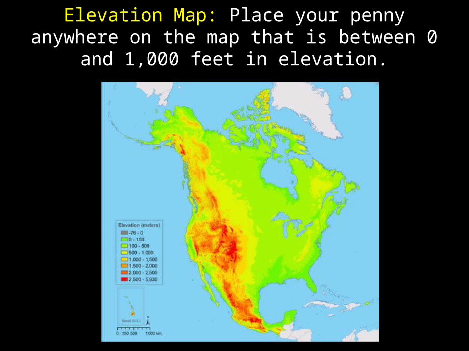
Elevation Map: Place your penny anywhere on the map that is between 0 and 1,000 feet in elevation.

Elevation Map: Place your penny anywhere on the map that is between 1,000 and 5,000 feet in
elevation.

Elevation Map: Place your penny anywhere on the map that is between 5,000 and 10,000 feet in
elevation.

Elevation Map: Place your penny anywhere on the map that is above 10,000 feet in elevation.
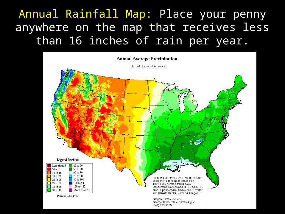
Annual Rainfall Map: Place your penny anywhere on the map that receives less than 16 inches of rain per
year.

Annual Rainfall Map: Place your penny anywhere on the map that receives more than 96 inches of rain per
year.

Annual Rainfall Map: Place your penny anywhere on the map that receives between 32 and 64 inches of rain per
year.

Population Density Map: Place your penny anywhere on the map where fewer than 10 people per square mile live.

Population Density Map: Place your penny anywhere on the map where more than 250 people per square mile live.

Population Density Map: Place your penny anywhere on the map where between 50 and 250 people per square
mile live.

Geography Challenge 2B: Challenge Questions 2B
Social Studies Alive Interactive Desk Map

Question 1: Which region has the highest elevation?

Question 2: Which state has the highest elevation?

Question 3: Which state has the most area at the highest elevation?

Question 4: Which region has the most area at an elevation of less than 1,000 feet?

Question 5: Which region receives the most annual rainfall?

Question 6: Which region receives the least annual rainfall?

Question 7: Which state receives less than 16 inches of rain each year?

Question 8: Which region has the highest population density (most people per square mile)?

Question 9: Which two regions have the lowest population density (fewest people per square mile)?

Question 10: Which three states have the lowest population density (fewest people per square mile)?

Concept Check
Social Studies Alive Interactive Desk Map

City #1:
First and Last Name
City #2:
City #3:

Clues for City #1

Clues for City #1
• The elevation of this city is just above sea level.• This city is in an area where the population density is above
250 people per square mile.• This city is in an area that receives between 64 and 96
inches of rain each year.• This city lies just north of 40 degrees north latitude.• This city lies just east of 75 degrees west longitude.

Clues for City #2
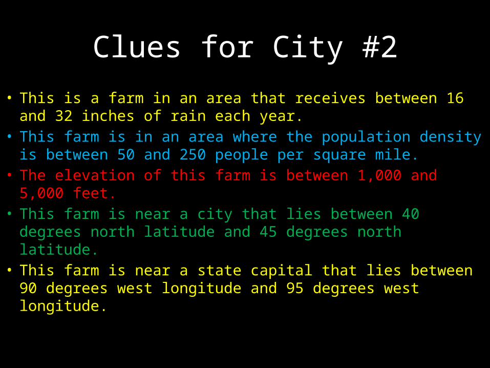
Clues for City #2
• This is a farm in an area that receives between 16 and 32 inches of rain each year.
• This farm is in an area where the population density is between 50 and 250 people per square mile.
• The elevation of this farm is between 1,000 and 5,000 feet.• This farm is near a city that lies between 40 degrees north
latitude and 45 degrees north latitude.• This farm is near a state capital that lies between 90
degrees west longitude and 95 degrees west longitude.

Clues for City #3

Clues for City #3
• The elevation of this city is between 0 and 1,000 feet.• This city is in an area where the population density is over
250 people per square mile.• This city receives between 16 and 32 inches of rain each year.• This city lies between 30 degrees north and 35 degrees north
latitude.• This lies between 95 degrees and 100 degrees west
longitude.• This city lies south of the Red River and north of the Brazos
River.
Regions of the United States: Physical Features and Ten Largest
Urban Areas Geography of the United States Graphic Organizer
History Alive Interactive Desk Map
Social Studies Alive Interactive Desk Map

46 degrees north latitude, 124 degrees west longitude
Physical Feature

41 degrees north latitude, 73.5 degrees west longitude
City

37 degrees north latitude, 122 degrees west longitude
City

27 degrees north latitude, 90 degrees west longitude
Physical Feature

35 degrees north latitude, 65 degrees west longitude
Physical Feature

30 degrees north latitude, 95.5 degrees west longitude
City

43 degrees north latitude, 96 degrees west longitude
Physical Feature

33.5 degrees north latitude, 112 degrees west longitude
City

38 degrees north latitude, 120 degrees west longitude
Physical Feature

29 degrees north latitude, 98 degrees west longitude
City

37 degrees north latitude, 86 degrees west longitude
Physical Feature

40 degrees north latitude, 100 degrees west longitude
Physical Feature

40 degrees north latitude, 75 degrees west longitude
City

32 degrees north latitude, 82 degrees west longitude
Physical Feature

35 degrees north latitude, 125 degrees west longitude
Physical Feature

33 degrees north latitude, 97 degrees west longitude
City

45 degrees north latitude, 83 degrees west longitude
Physical Feature

46 degrees north latitude, 94 degrees west longitude
Physical Feature

33 degrees north latitude, 117 degrees west longitude
City

46 degrees north latitude, 73 degrees west longitude
Physical Feature

30 degrees north latitude, 95 degrees west longitude
Physical Feature

42 degrees north latitude, 87 degrees west longitude
City

40 degrees north latitude, 77 degrees west longitude
Physical Feature

30 degrees north latitude, 102 degrees west longitude
Physical Feature

44 degrees north latitude, 110 degrees west longitude
Physical Feature

34 degrees north latitude, 118 degrees west longitude
City


![[PPT]PowerPoint Presentation Women's Rights.ppt · Web viewThroughout early American history women were seen as virtuous protectors of American ideals - liberty, freedom and righteousness](https://img.pdfslide.us/doc/110x75/5af882157f8b9a8d1c91975a/pptpowerpoint-womens-rightspptweb-viewthroughout-early-american-history-women.jpg)