Embed Size (px)
Citation preview
The Puerto Rico Trench, the deepest part ofthe Atlantic Ocean, is located where the NorthAmerican (NOAM) plate is subducting under theCaribbean plate (Figure 1).The trench regionmay pose significant seismic and tsunami haz-ards to Puerto Rico and the U.S.Virgin Islands,where 4 million U.S.citizens reside.Widespreaddamage in Puerto Rico and Hispaniola froman earthquake in 1787 was estimated to be theresult of a magnitude 8 earthquake north of theislands [McCann et al., 2004].A tsunami killed40 people in NW Puerto Rico following a mag-nitude 7.3 earthquake in 1918 [Mercado andMcCann, 1998]. Large landslide escarpmentshave been mapped on the seafloor north ofPuerto Rico [Mercado et al., 2002; Schwab etal., 1991], although their ages are unknown.
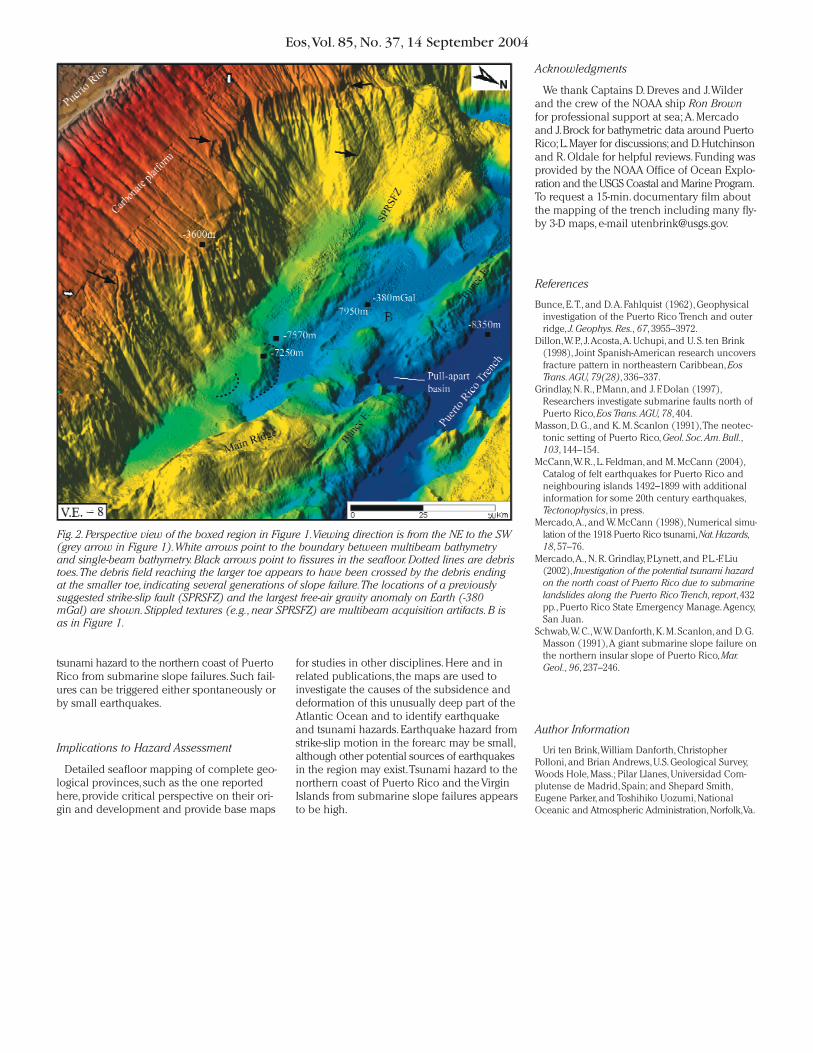
The Puerto Rico Trench is atypical of oceanictrenches.Subduction is highly oblique (10°–20°)to the trench axis with a large component ofleft-lateral strike-slip motion.Similar convergencegeometry is observed at the Challenger Deepin the Mariana Trench, the deepest point onEarth. In addition to its extremely deep seafloor,the Puerto Rico Trench is also characterizedby the most negative free-air gravity anomalyon Earth, -380 mGal, located 50 km south ofthe trench, where water depth is 7950 m (Fig-ure 2).A tilted carbonate platform providesevidence for extreme vertical tectonism in theregion.This platform was horizontally depositedover Cretaceous to Paleocene arc rocks start-ing in the Late Oligocene.Then, at 3.5 Ma, thecarbonate platform was tilted by 4° towardthe trench over a time period of less than 40kyr, (U. S. ten Brink et al., manuscript in prepa-ration, 2004) such that its northern edge is at adepth of 4000 m and its reconstructed eleva-tion on land in Puerto Rico is at +1300 m (Fig-ures 1 and 2).
To help understand the origin of the unusualbathymetry, gravity, and vertical tectonics of
the plate boundary and to provide constraintsfor hazard assessment, the morphology of theentire 770-km-long trench from the DominicanRepublic in the west to Anguilla in the eastwas mapped with multibeam echosounderduring three cruises in 2002 and 2003.Parts of thePuerto Rico Trench were previously surveyedwith side-scan sonar [Grindlay et al., 1997] andmultibeam echosounder [Dillon et al., 1998;Grindlay et al., 1997], often at lower resolutionand with line orientation and spacing that didnot provide complete bathymetric coverage.
The data presented here were collectedusing the SeaBeam 2112 multibeam systemaboard the National Oceanic and AtmosphericAdministration (NOAA) ship Ron Brown, withsufficient swath overlap and proper line orien-tation for hydrographic survey.The data weregridded at 150-m grid size following resolutiontests.Vertical resolution is estimated to be0.5–1% of the water depth (10–80 m; L. Mayer,oral communication,2003).Backscatter mosaicimages derived from the multibeam bathymetrydata aided in interpretation.The total mappedarea is 100,000 km2, slightly smaller than thearea of the state of Virginia.
Subsidence of the Trench
The trench can be divided into two parts atabout 65°–66°W.The western part includes thedeepest sector of the trench,and is associatedwith the most oblique convergence.This sectoris 10–15 km wide and 8300–8340 m deep rela-tive to mean sea level (Figure 1). It is remark-ably flat and is covered by nonreflective pelagicsediments.Seismic profiles show it to be under-lain by rotated blocks of the NOAM plate thatindicate trench subsidence.The unusual depthextends southward over parts of the forearc.The trench floor narrows to the west and abruptlyshallows to 4700 m as it turns into the HispaniolaTrench, where convergence is more perpendi-cular.The eastern part of the trench is shallowerby 700 m and more rugged than the deepwestern part.The subducting NOAM plate isobserved in seismic lines to be broken intoblocks,but the descending blocks are not rotated.
Deformation of the Subducting Plate
The trench wall north of the eastern part ofthe trench is cut by a series of normal faultswith vertical throw up to 1500 m.Deformationcuts across remnant abyssal-hill lineaments thatwere presumably created near the spreadingridge, and is probably related to the bendingof the NOAM plate around and under thecurved subduction zone. Submarine slidescarps and slide toes were observed for thefirst time on the northern trench wall, thelargest of which (at 68°W) is 20 km wide.Theareas to the north and the west of that slide,including the steep slopes of Navidad Bank,show numerous submarine slide scarps.
Strain Partitioning in the Forearc
A 535-km-long fault is located 10–15 kmsouth of the trench and passes through roundedhills that form the accretionary prism (Figure1).The fault is interpreted to accommodateleft-lateral motion because it is offset around apull-apart depression (Figures 1 and 2).Seismicreflection data show the steeply dipping faultto penetrate 5 km through the accretionarysediments before terminating in the subduc-tion interface [ten Brink and Lin, Stress inter-action between subduction earthquakes andforearc strike-slip faults: modeling and appli-cations, submitted to J.Geophys.Res.SolidEarth,2004].Part of this fault trace was firstidentified as a weak lineament on a Gloriabackscatter image [Masson and Scanlon,1991] and was named the Northern PuertoRico Slope Fault Zone [Grindlay et al.,1997].The authors propose renaming this distinctregional fault the “Bunce fault”after the lateElizabeth Bunce,a pioneer marine geophysi-cist who explored the Puerto Rico Trench inthe 1950s [Bunce and Fahlquist, 1962].
Bunce fault ends at the western end of thePuerto Rico Trench in several splays, typical ofdistributed deformation at the end of largestrike-slip faults, such as the Alpine fault ofNew Zealand.The fault appears to be the onlyactive strike-slip fault along most of this highlyoblique subduction zone. Its proximity to thetrench suggests that slip along the subductioninterface is effectively oblique,which is in agree-ment with GPS measurements and earthquakefocal mechanisms [ten Brink and Lin, Stressinteraction between subduction earthquakesand forearc strike-slip faults: modeling andapplications, submitted to J.Geophys.Res.SolidEarth,2004].Another fault closer to Puerto Rico(the South Puerto Rico Slope Fault Zone
VOLUME 85 NUMBER 37
14 SEPTEMBER 2004
PAGES 349–360
Eos,Vol. 85, No. 37, 14 September 2004
EOS,TRANSACTIONS, AMERICAN GEOPHYSICAL UNION
PAGES 349, 354
New Seafloor Map of the Puerto Rico Trench Helps AssessEarthquake and Tsunami Hazards
BY U.TEN BRINK,W. DANFORTH, C. POLLONI,B.ANDREWS, P. LLANES, S. SMITH, E PARKER,AND
T. UOZUMI
Eos,Vol. 85, No. 37, 14 September 2004
(SPRSFZ) [Grindlay et al., 1997]), which waspreviously proposed to be active, has no clearexpression in the bathymetry (Figure 2).Therefore, earthquake hazard to Puerto Ricofrom strike-slip faults in the forearc appears low,because only the Bunce fault appears active;it is located ~110 km away, it is ~5 km deep,and it offsets partially consolidated sediments.
Bunce fault is deflected southward at 65°W,perhaps because this section was perturbedby the oblique subduction of Main Ridge.Main Ridge is interpreted to be underlain by asubducted ridge of seamounts because itsaxis is perpendicular to the observed abyssal-hillgrain of the subducting NOAM plate (Figure 1).The subduction of the ridge has generatedSW trending strike-slip fault in its wake, thrustfaults with opposing dips on both sides of theridge, and a reentrant in the trench axis, aspredicted by sandbox models of subductingseamounts.Earthquake focal mechanisms andcrossing seismic profiles indicate that thesethrust faults are active and may present someseismic hazard.
A fault trace at the SW edge of the image is inter-preted to be the eastern end of Septentrional
fault, a major active fault in Hispaniola. Left-lateral motion is inferred from the existence of asmall pull-apart basin along the fault (A inFigure 1).The fault ends abruptly in a 1000-m-deep circular depression 25 km west of MonaRift, contrary to previous suggestions that itcontinues eastward across Mona Rift and alongthe base of the Puerto Rico slope.
Rifts in the Forearc and the Subduction Zone
Mona Rift NW of Puerto Rico consists ofthree en-echelon depressions (5000, 7800, and8150 m), which cut the carbonate platformand extend almost to the Bunce fault (Figure 1).The rift probably accommodates minor E-Wextension between Hispaniola and PuertoRico.A large slump failure along the westernwall of the upper rift basin may be related tothe 1918 earthquake and tsunami.
The Anegada Passage south of the Virgin Islandsis a series of deep depressions that were prob-ably formed by a mixture of normal andstrike-slip motion. Several reconstructions andtectonic analyses of the northeast Caribbeanshow the trough to be a crustal boundary
between a block comprising Puerto Rico andthe Virgin Islands and the Lesser Antilles Arcand, as such, extended the boundary to thetrench [e.g., Masson and Scanlon, 1991].Thismap shows that the Anegada Passage probablyends in the Sombrero Basin and does notconnect to the trench.
Active Submarine Slides at the Edge of the Carbonate Platform
Two semicircular escarpments,30–50 km across,are mapped along the northern edge of thecarbonate platform at a distance of 35–50 kmnorth of Puerto Rico (Figure 2).Our bathymetryand side-scan images indicate that the semicir-cular scarps were not formed each by a singlecatastrophic failure, as previously suggested[Mercado et al., 2002; Schwab et al., 1991], butwere shaped by continuous retrograde slumpingof smaller segments. Fissures near the edge ofthe carbonate platform indicate that theslumping process is ongoing (Figure 2).At theplatform margin, the slope of the seafloorreaches 45°, and the water depth increases by4000 m.Therefore, there may be significant
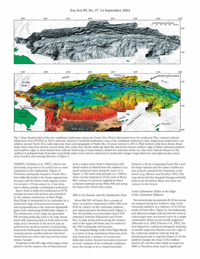
Fig.1.(top) Shaded relief of the new multibeam bathymetry along the Puerto Rico Trench illuminated from the northwest.Thin contours indicatebathymetry from ETOPO2 at 500-m intervals. (bottom) Combined bathymetry map of the multibeam bathymetry data, single-beam bathymetry com-pilation around Puerto Rico, Lidar data near shore,and topography of Puerto Rico.Contour interval is 500 m.Thick barbed white lines denote thrustfaults; thick white lines denote normal faults; thin white lines denote strike-slip fault; thin black lines denote northern edge of tilted carbonate platformand southern edge on land; dashed lines indicate head scarp of slope failures; dotted line indicates debris toe; blue lines indicate fissures in theseafloor; A,pull-apart basin; B,location of probable extinct mud volcano observed on backscatter images.Large black box and adjacent grey arrowshow location and viewing direction of Figure 2.
Eos,Vol. 85, No. 37, 14 September 2004
tsunami hazard to the northern coast of PuertoRico from submarine slope failures. Such fail-ures can be triggered either spontaneously orby small earthquakes.
Implications to Hazard Assessment
Detailed seafloor mapping of complete geo-logical provinces, such as the one reportedhere, provide critical perspective on their ori-gin and development and provide base maps
for studies in other disciplines. Here and inrelated publications, the maps are used toinvestigate the causes of the subsidence anddeformation of this unusually deep part of theAtlantic Ocean and to identify earthquakeand tsunami hazards. Earthquake hazard fromstrike-slip motion in the forearc may be small,although other potential sources of earthquakesin the region may exist.Tsunami hazard to thenorthern coast of Puerto Rico and the VirginIslands from submarine slope failures appearsto be high.
Acknowledgments
We thank Captains D. Dreves and J.Wilderand the crew of the NOAA ship Ron Brownfor professional support at sea; A. Mercadoand J.Brock for bathymetric data around PuertoRico;L.Mayer for discussions;and D.Hutchinsonand R.Oldale for helpful reviews.Funding wasprovided by the NOAA Office of Ocean Explo-ration and the USGS Coastal and Marine Program.To request a 15-min. documentary film aboutthe mapping of the trench including many fly-by 3-D maps, e-mail [email protected].
References
Bunce, E.T., and D.A. Fahlquist (1962), Geophysicalinvestigation of the Puerto Rico Trench and outerridge, J.Geophys.Res., 67, 3955–3972.
Dillon,W. P., J.Acosta,A. Uchupi, and U. S. ten Brink(1998), Joint Spanish-American research uncoversfracture pattern in northeastern Caribbean, EosTrans.AGU,79(28), 336–337.
Grindlay, N. R., P. Mann, and J. F. Dolan (1997),Researchers investigate submarine faults north ofPuerto Rico, Eos Trans.AGU,78, 404.
Masson, D. G., and K. M. Scanlon (1991),The neotec-tonic setting of Puerto Rico, Geol. Soc.Am.Bull.,103, 144–154.
McCann,W. R., L. Feldman, and M. McCann (2004),Catalog of felt earthquakes for Puerto Rico andneighbouring islands 1492–1899 with additionalinformation for some 20th century earthquakes,Tectonophysics, in press.
Mercado,A., and W. McCann (1998), Numerical simu-lation of the 1918 Puerto Rico tsunami,Nat.Hazards,18, 57–76.
Mercado,A., N. R. Grindlay, P. Lynett, and P. L.-F. Liu(2002), Investigation of the potential tsunami hazardon the north coast of Puerto Rico due to submarinelandslides along the Puerto Rico Trench, report, 432pp., Puerto Rico State Emergency Manage.Agency,San Juan.
Schwab,W. C.,W.W. Danforth, K. M. Scanlon, and D. G.Masson (1991),A giant submarine slope failure onthe northern insular slope of Puerto Rico, Mar.Geol., 96, 237–246.
Author Information
Uri ten Brink,William Danforth, Christopher Polloni, and Brian Andrews, U.S. Geological Survey,Woods Hole, Mass.; Pilar Llanes, Universidad Com-plutense de Madrid, Spain; and Shepard Smith,Eugene Parker, and Toshihiko Uozumi, NationalOceanic and Atmospheric Administration,Norfolk,Va.
Fig.2.Perspective view of the boxed region in Figure 1.Viewing direction is from the NE to the SW(grey arrow in Figure 1).White arrows point to the boundary between multibeam bathymetryand single-beam bathymetry.Black arrows point to fissures in the seafloor.Dotted lines are debristoes.The debris field reaching the larger toe appears to have been crossed by the debris endingat the smaller toe, indicating several generations of slope failure.The locations of a previouslysuggested strike-slip fault (SPRSFZ) and the largest free-air gravity anomaly on Earth (-380mGal) are shown.Stippled textures (e.g., near SPRSFZ) are multibeam acquisition artifacts.B isas in Figure 1.