Embed Size (px)
Citation preview
Amendment No. 3. to the Agreement for Professional Design Services with Jacobs Engineering Group, Inc.
for the North County Corridor Transportation Expressway Project
This Amendment is made and entered into on , in the City of Modesto, State of California, by and between the North County Corridor Transportation Authority (NCCTEA) and Jacobs Engineering Group, Inc., (“CONSULTANT”), for and in consideration of the promises, and the mutual promises, covenants, terms, and conditions, hereinafter contained. WHEREAS, the North County Corridor Project has moved forward with Task Order #3 as defined in the March 11, 2009 Board action and better defined in Amendment 2 and; WHEREAS, revisions to the contracted scope of work is identified as described in the attached Jacobs Engineering letter dated September 2, 2011 and required to complete Task Order #3, and; WHEREAS, an adjustment to the amount of compensation as originally stated in the Agreement is necessary to complete the project; Now therefore, the parties herby agree to amend the Agreement as follows:
1. Exhibit C of Amendment 2 Scope of Services is amended and attached as Exhibit C – A3.
2. Paragraph 2.1 Compensation is amended to read as follows: 2.1. Compensation. Consultant shall be paid in accordance with the fee schedules approved by NCC TEA for each Task Order, which schedules are attached hereto as Exhibit “C-A3” and made a part of the Agreement. Consultants compensation under this Agreement shall in no case exceed a total of Nine Million Sixty-eight Thousand seven Hundred sixty five Dollars ($9,068,765). Said compensation shall include, but not be limited to the approved scope of work and schedule. 3. Paragraph 3.1 Commencement and Completion of Work is amended to read as follows: The professional services to be performed pursuant to the Agreement shall commence within five (5) days after NCCTEA delivers a Notice to Proceed for a specified Task Order. Said services shall be performed in strict compliance with the Project Scheduled approved by NCCTEA as set forth in Exhibit “D” of Amendment 2. The Project Schedule may be amended by mutual agreement of the parties. Failure to commence work in a timely manner and/or diligently pursue work to completion may be grounds for termination of this Agreement. All other terms and conditions of said Agreement shall remain in full force and effect.
Amendment No. 3. to the Agreement for Professional Design Services with Jacobs Engineering Group, Inc.
for the North County Corridor Transportation Expressway Project
In witness whereof, the parties have executed this Amendment effective on the date written above. COUNTY OF STANISLAUS JACOBS ENGINEERING GROUP, INC. By:____________________________ _______________________________ Matt Machado, Director Kevin J. McMahon Department of Public Works Group Vice President, NAI Jacobs Engineering APPROVED AS TO FORM John P. Doering, County Counsel By:__________________________ Thomas E. Boze Deputy County Counsel
180 Promenade Circle, Suite 300 Sacramento, CA 95834 USA 1.916.929.3323 Fax 1.916.929.1772
November 2011 Page 1
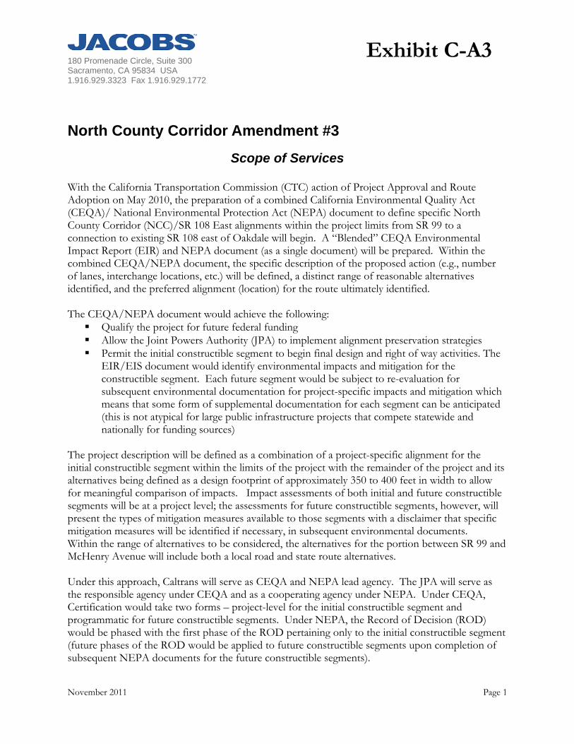
North County Corridor Amendment #3
Scope of Services With the California Transportation Commission (CTC) action of Project Approval and Route Adoption on May 2010, the preparation of a combined California Environmental Quality Act (CEQA)/ National Environmental Protection Act (NEPA) document to define specific North County Corridor (NCC)/SR 108 East alignments within the project limits from SR 99 to a connection to existing SR 108 east of Oakdale will begin. A “Blended” CEQA Environmental Impact Report (EIR) and NEPA document (as a single document) will be prepared. Within the combined CEQA/NEPA document, the specific description of the proposed action (e.g., number of lanes, interchange locations, etc.) will be defined, a distinct range of reasonable alternatives identified, and the preferred alignment (location) for the route ultimately identified. The CEQA/NEPA document would achieve the following: Qualify the project for future federal funding Allow the Joint Powers Authority (JPA) to implement alignment preservation strategies Permit the initial constructible segment to begin final design and right of way activities. The
EIR/EIS document would identify environmental impacts and mitigation for the constructible segment. Each future segment would be subject to re-evaluation for subsequent environmental documentation for project-specific impacts and mitigation which means that some form of supplemental documentation for each segment can be anticipated (this is not atypical for large public infrastructure projects that compete statewide and nationally for funding sources)
The project description will be defined as a combination of a project-specific alignment for the initial constructible segment within the limits of the project with the remainder of the project and its alternatives being defined as a design footprint of approximately 350 to 400 feet in width to allow for meaningful comparison of impacts. Impact assessments of both initial and future constructible segments will be at a project level; the assessments for future constructible segments, however, will present the types of mitigation measures available to those segments with a disclaimer that specific mitigation measures will be identified if necessary, in subsequent environmental documents. Within the range of alternatives to be considered, the alternatives for the portion between SR 99 and McHenry Avenue will include both a local road and state route alternatives. Under this approach, Caltrans will serve as CEQA and NEPA lead agency. The JPA will serve as the responsible agency under CEQA and as a cooperating agency under NEPA. Under CEQA, Certification would take two forms – project-level for the initial constructible segment and programmatic for future constructible segments. Under NEPA, the Record of Decision (ROD) would be phased with the first phase of the ROD pertaining only to the initial constructible segment (future phases of the ROD would be applied to future constructible segments upon completion of subsequent NEPA documents for the future constructible segments).
Exhibit C-A3
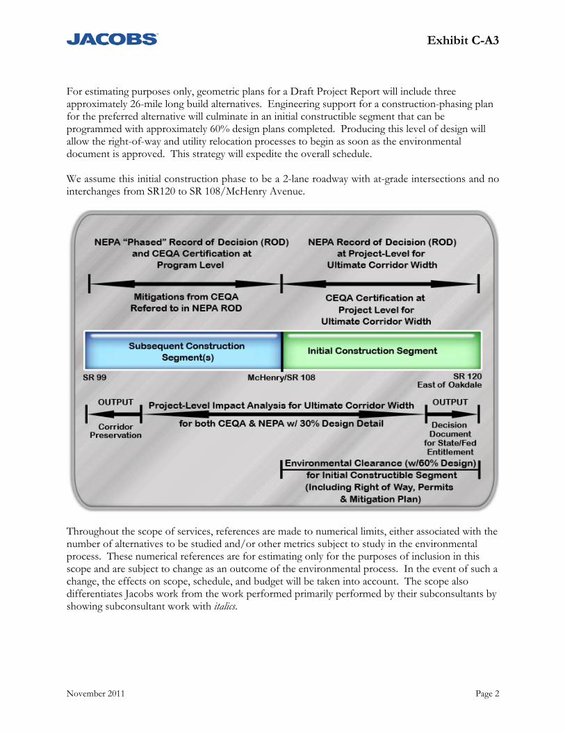
Exhibit C-A3
November 2011 Page 2
For estimating purposes only, geometric plans for a Draft Project Report will include three approximately 26-mile long build alternatives. Engineering support for a construction-phasing plan for the preferred alternative will culminate in an initial constructible segment that can be programmed with approximately 60% design plans completed. Producing this level of design will allow the right-of-way and utility relocation processes to begin as soon as the environmental document is approved. This strategy will expedite the overall schedule. We assume this initial construction phase to be a 2-lane roadway with at-grade intersections and no interchanges from SR120 to SR 108/McHenry Avenue.
Throughout the scope of services, references are made to numerical limits, either associated with the number of alternatives to be studied and/or other metrics subject to study in the environmental process. These numerical references are for estimating only for the purposes of inclusion in this scope and are subject to change as an outcome of the environmental process. In the event of such a change, the effects on scope, schedule, and budget will be taken into account. The scope also differentiates Jacobs work from the work performed primarily performed by their subconsultants by showing subconsultant work with italics.
Exhibit C-A3
November 2011 Page 3
Project Management (WBS 100.10)
Project Initiation & Planning (WBS 100.10.05) Scope of Services: Initiation of the EIR/EIS phase of the work involves developing a scope and schedule that
is acceptable to the JPA Project Manager and Caltrans. Work to include negotiations with Caltrans and subconsultants to arrive at a cost, scope and schedule along with set of assumptions to deliver the EIR/EIS.
Work includes preparation of Project Management Plan and Communication Plan. The PMP will include a communication plan to address communication protocols among the lead agency, the responsible/cooperating agency(ies), and consultants by staff type and a Risk Management Plan for assessing risk to cost, scope and schedule
Jacobs team will research materials related to resolve the issue of preparing financial plan for FHWA. This include meeting with Caltrans, FHWA, JPA staff, etc. Scope also includes internal project kick off meeting with the entire project team, including sub consultants.
Preparation of Project Charter Deliverables: Approved Scope, Cost and Schedule Project Management Plan Communication Plan Resolution on Financial Plan Risk Management Plan Project Charter
Execution and Control (WBS 100.10.10)
Scope of Services: Update to Project Management Plan
Submit up to 15 approved schedule updates, to reflect changes in project process and schedule of activities
Prepare and submit to 45 monthly invoices and progress reports
Monthly progress updates
Manage scope, schedule and budget
Maintain project files in Prime Consultant’s office in a manner that is consistent with Caltrans’ filing requirements in support of an administrative record, if needed
Provide JPA with project files at close out of contract
Deliverables: Approved Project schedule updates (15)
Monthly Project invoices and progress reports
Revised Project Management Plan and Risk Management Plan (15)
Administrative Record
Exhibit C-A3
November 2011 Page 4
Assumptions: The communication plan portion of the PMP will be subject to one review by Caltrans and
the JPA
The PMP will be reviewed three times through the course of the project
Coordination and Meetings (WBS 100.10.15)
Scope of Services: Organize, conduct, and document meetings that include the following:
– monthly Project Development Team (PDT) Meetings (45), that include Consultant Team Leaders, Caltrans and JPA participations,
– Participation at Caltrans Management Briefings (16). – Attendance at CTC Meeting and Coordination with CTC Commissioners (6), – Attendance at TAC Meetings, Agency Briefings/Presentations (32), – General Plan Update Meetings and Presentations (10), – Oakdale By-pass Right-of-Way Abandonment Coordination and Meetings (3), – ConAgra Coordination and Meetings (3), – One-on-one meetings with key members of the public (6), – Focus Meetings for Environmental (20), Design (20) and Traffic (5 conference calls) – Contingency for any other Project Coordination Meetings required during the course of
the project (10) – Weekly team leader coordination conference calls (45 months) – Briefing Meetings with Councils, Boards, Supervisors and Management (21) All meetings will include discussion of work progress, plans for the next period, potential problems, and other project issues.
Ongoing recommendations for cross-meeting coordination and facilitation and content improvement.
Deliverables Agendas and meeting summaries for all meetings
Assumptions It is assumed that the Caltrans Management Briefings will taper off after the project gets
started.
It is assumed that the TAC meetings will not occur every month
Exhibit C-A3
November 2011 Page 5
Quality Control Program (WBS 100.10.20)
Scope of Services: Prepare a QA/QC Plan for the environmental document preparation. The plan will include
document style requirements and QA/QC processes for all deliverables associated with the CEQA/NEPA processes.
Perform Independent Third Party quality control reviews by a qualified Jacobs staff member that is independent from the project in accordance with the approved QA/QC Program for the reports, plans, studies, estimates, and other documents submitted. “Continuous” quality control reviews by discipline and task managers and their production staff is included in the respective production tasks. The QA/QC Independent Third Party review is for the separate, milestone independent review of major deliverable documents (e.g., Project Report, Environmental Document and Technical Studies, etc.)
Deliverables Environmental QA/QC Plan to include review processes and style guide
Quality Control reviews of deliverable products, including documentation by the reviewers of their reviews for all deliverables associated with the CEQA/NEPA processes.
Consensus Building and Outreach EIR/EIS (WBS 100.10.99)
Stakeholder Meetings (WBS 100.10.99)
Scope of Services: Schedule, prepare agenda, make arrangements, and attend up to fifteen (15) meetings with key stakeholders
to discuss issues of pertinent interest.
Extend invitations, confirm attendance, and provide summary reports of each meeting.
Deliverables: Meetings with key stakeholders
Summary reports of each meeting with key stakeholders
Public Meetings (WBS 100.10.99)
Scope of Services: Plan and organize public workshops/meetings/hearings as part of the environmental process: up to three
public workshop (held at separate locations throughout the duration of the project),and two scoping meetings (held in separate locations as a set coinciding with the start of environmental scoping) to update the community on the project and comply with environmental process requirements.
Prepare, print, and distribute notification materials, including, but not limited to, display advertisements and placements, news releases, direct mail, Web site to key stakeholders and the general community.
Prepare and transmit elected officials letters to Caltrans.
Exhibit C-A3
November 2011 Page 6
Prepare and print/produce meeting materials, including up to 20 exhibit boards, PowerPoint presentations, agendas, FAQs, sign-in sheets, comment sheets, name badges, signage, and refreshments.
Identify appropriate locations to host the workshops for approximately 150 to 200 attendees and make all arrangements.
Arrange for, participate in, follow-up to “dry run” with Caltrans executives. Organize, conduct, and facilitate workshops.
Arrange for public stenographer at the workshops and scoping meetings.
Document workshops and meeting proceedings, including comments from participants.
Identify key issues of concern among stakeholders
Develop strategic approach to issues management.
Develop recommendations for a program of enhanced multi-cultural involvement. Supply light refreshments at public meetings
Traditional outreach methods are rarely effective with audiences for whom the processes are unfamiliar. Translated materials are typically inadequate in generating interest and involvement from diverse audiences who may find basic elements, such as right-of-entry requests, invasive and even threatening. These groups may be reluctant to attend public meetings, and suspicious of other contacts. The Jacobs team will assist the Project Team assess the need for multicultural communications and involvement, identify key communities, determine essential resources and develop cultural-specific recommendations for involving those communities in ways which best meet project needs and objectives
Deliverables: Notification materials (workshop/meeting announcements, display advertisements, news
releases, elected officials letters, Web site announcements, direct mail)
Workshop and meeting materials (PowerPoint presentations/exhibit boards (20), agendas, FAQs, sign-in sheets, comment sheets, name badges, signage, refreshments)
Dry run with Caltrans executives
Workshop and meeting arrangements
Meeting Summary Reports including comments provided to a public stenographer at workshops and scoping meetings
Detailed workshop and meeting summary reports
Multi-cultural implementation plan.
Assumptions: It is assumed Jacobs will provide up to six staff at public meetings.
Notifications—five: one for each of the three workshops, one to advertise the set of two scoping meetings
o Advertisements (Modesto Bee; Vida en el Valle, Bilingual Weekly, or Latino Times; Oakdale Leader; Riverbank News)
o News releases o Direct mail o Web

Exhibit C-A3
November 2011 Page 7
Meeting Materials o Exhibit boards (total of 20 for all meetings, one review cycle with Caltrans and JPA) o Presentations o Agendas (5) o FAQs (5) o Sign-in sheets (5) o Comment sheets (5) o Name badges o Refreshments (cookies, coffee, tea) o Facilitation/attendance at all seven events o Summary reports/documentation (5) o General logistics (4): one for each of the three workshops, one to advertise the set of
two scoping meetings o Spanish-language translation of print materials and at workshops, meetings o Upcoming postage increases included
Agency Coordination (WBS 100.10.99) 6002 Process
Scope of Services: Prepare and administer 6002 Coordination Plan to include regularly scheduled agency
coordination meetings
Conduct an agency scoping meeting at the start of the project
Identify and maintain agency representative and key stakeholder list for ongoing coordination and discussion of issues.
Deliverables
Agency and key stakeholder contact list
Information and presentation materials for agency meetings
Meeting agendas and summaries with action item lists
6002 Plan
Assumptions: Jacobs will facilitate and attend six (6) agency coordination meetings in accordance with the
6002 Plan.
The draft 6002 Plan will be subject to one review by Caltrans.
The Plan will be reviewed twice a year to determine if updates are required
Meeting location to be determined with JPA and for the convenience of agency members
Database Development and Comment Tracking (WBS 100.10.99)
Scope of Services: Supplement existing contact information using Parcel Quest to identify adjacent property owners and
neighbors.
Research and identify additional stakeholders and interested parties.

Exhibit C-A3
November 2011 Page 8
Develop and maintain database for up to 7,000 contacts for the duration of the contract.
Provide up to four Comment Tracking Reports outlining categories of issues and disposition.
Database will catalog and track comments, issues, and resolutions originally identified by key stakeholders, who include, but are not limited to, community members, property owners, business interests, civic and community organizations, interested agencies, and elected officials.
Database will catalog attendance at workshops and other meetings.
Deliverables: Database with contact information and activity/issues/comments noted
Comment Tracking Reports, up to four
Assumptions: StanCOG, Stanislaus County, Modesto, Riverbank and Oakdale will provide existing contact
information in electronic format.
The JPA and Caltrans will approve/revise proposed database contacts in one review cycle.
Facts Sheets (WBS 100.10.99)
Scope of Services: Develop outlines and appropriate topics for fact sheets (combined document).
Develop content and print three fact sheets in color (kickoff, update, and conclusion of consensus building) to update interested parties on the project development (information and process).
Distribute the three fact sheets as follows: o Make available at workshops.
Deliverables: Three printed fact sheets
Assumptions: Newsletters, fact sheets and other products to be made available for public consumption will
be subject to review and approval by the JPA and Caltrans.
It is assumed newsletters, etc. will be subject to one review by the JPA and by Caltrans
Jacobs project management maintains responsibility over published materials and therefore must review these materials prior to JPA and Caltrans review
Website Coordination (WBS 100.10.99)
Scope of Services: Coordinate with Caltrans (and JPA) to provide content for project Caltrans Web site at scheduled intervals,
including, but not limited to, workshop notifications and summary reports.
Provide project materials for placement on the Caltrans (with link on JPA site) Web site upon approval by JPA.
Develop recommended social media activities and strategies, designed to support website traffic.
Exhibit C-A3
November 2011 Page 9
Deliverables: Web site updates, including, but not limited to, workshop notifications and summary
reports.
Record of items posted to Web site
Assumptions: Jacobs project management maintains responsibility over published materials and therefore
must review these materials prior to JPA and Caltrans review
Caltrans will host the web site
Web site updates (text and documents) Updates after each set of workshops/scoping meetings/public hearings (approximately 3)
Updates after an alternative has been screened from consideration (approximately 3)
Updates as other events warrant (approximately 4)
Media Coordination (WBS 100.10.99)
Scope of Services: Coordinate with JPA staff to identify appropriate contacts for both mainstream (e.g., newspapers, radio,
television) and alternative (e.g., community newsletters, Facebook) media.
Maintain media contact list. Produce and distribute press kits, including news releases and project information, as appropriate, e.g., public
workshops.
Track news articles related to the project, distribute to project management, and maintain media coverage file on project.
Deliverables: Media releases
Media list
Press kits
Media coverage file
Articles to project management
Assumptions: All deliverables will be subject to one review cycle by Caltrans and the JPA
Perform Preliminary Engineering Studies and Draft Project Report (WBS 160)
Scope of Services: Update Project Information – Prepare PSR-PDS.
Exhibit C-A3
November 2011 Page 10
Develop Preliminary Geometric Plans for project alternatives for use in establishing Environmental Study Limit (ESL)
Prepare Preliminary Right-of-Way Requirements (Maps) for each alternative for use in Right-of-way Data Sheets
Perform Traffic Forecasts/Modeling, Traffic Operational Analysis and Traffic Study
Perform Value Analysis for Project
Perform Structure Advance Planning Studies
Perform Hydrology/Hydraulics Studies
Prepare Right of Way Data Sheet
Define Utilities Requirements for the Project Alternatives
Review and Perform Railroad Study
Perform Preliminary Geotechnical Studies
Perform Structural Preliminary Geotechnical Studies
Prepare Design Exceptions Fact Sheets
Develop Project Cost Estimates
Develop Transportation Management Plan
Develop Storm Water Data Report
Prepare Draft Project Report
Assumptions Caltrans’ Project Report format will be used
Traffic analysis done as part of the Route Adoption will be further developed to address Caltrans requirements in Caltrans WBS 160.10.35
Three Caltrans DRAFT Project Report (PR) review cycle are assumed. The review cycles are defined as the Administrative Draft PR, Draft PR, and Final Draft PR. (NOTE: Final PR is under Task 8)
Traffic Data Collection and Updates (WBS 160.05.20) The Traffic scope of work presented in this document contains two unique work efforts. One is similar to the scope of work prepared for the North County Corridor State Route 108 East Route Adoption (SR 108 East Project) at a program level, and will have the limits identified in the WBS title as SR99 to SR120/108. The other one is to complete the traffic analysis for the first constructible phase of the project. The first constructible phase of the project has been identified as the roadway segment between McHenry Avenue and SR 120/108 east of Oakdale. The scope for this first constructible phase of the project includes peak hour roadway segment analysis and peak hour intersection level of service analysis for the proposed alternatives. This work effort for the first constructible segment will have the limits identified in the WBS title as “McHenry Avenue to SR120/108.
Exhibit C-A3
November 2011 Page 11
WBS 160.05.20 - Identify Study Locations and Collect Traffic Data (SR 99 to SR 120/108) This scope assumes that the same roadway locations evaluated for the SR 108 East Project are the same roadway locations evaluated for this study. A complete list of existing roadway locations is presented at the end of this scope. If this is the case then no new daily roadway volume data will be collected. All of the previous data for the SR 108 East Project will be summarized and presented. Figure 1 attached to this scope of work presents the study roadway segments and existing average daily traffic volumes. The majority of the data was collected in the fall/summer of 2008. Considering that the number of homes and jobs has remained relatively flat for the last several years the data collected in 2008 continues to remain valid. Based on a request from the project team new roadway volumes will be collected at 10 locations to identify the potential volume changes from very recent land use/traffic circulation changes. The locations will be selected in consultation with the project team.
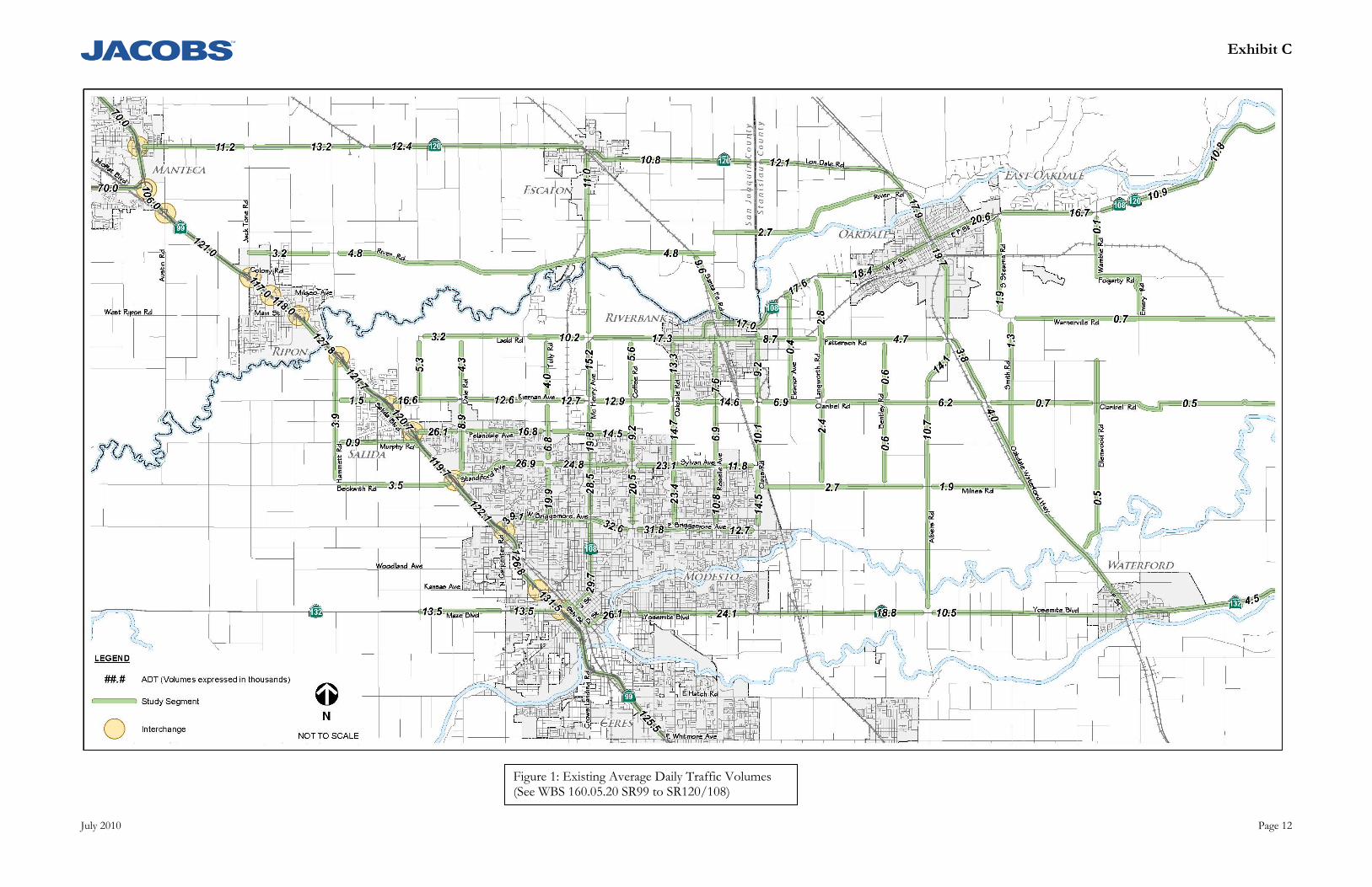
Exhibit C
July 2010 Page 12
Figure 1: Existing Average Daily Traffic Volumes (See WBS 160.05.20 SR99 to SR120/108)
Exhibit C
July 2010 Page 13
WBS 160.05.20 – Identify Study Locations and Collect Traffic Data (McHenry Ave to SR120/108) As part of the North County Corridor State Route 108 East Route Adoption Project Jacobs team identified the potential changes in traffic volumes in northern Stanislaus County resulting from the implementation of the project. Based on those results (see Figure 2) the project would result in changes primarily along SR 108, Patterson Road, Claribel Road, and Pelandale Avenue. Jacobs team has used this information to help identify the study locations for this study. Jacobs team, in consultation with the Project Team, will collect existing AM (7-9 AM) and PM (4-6 PM) peak period intersection traffic counts at up to 17 intersections. Jacobs team will also perform peak period field surveys to identify existing geometric features, lane configurations, and traffic control devices at the intersections and roadway locations identified by the Project Team. We will also identify existing queuing issues at each of the study intersections. Jacobs team has identified the following intersections to evaluate (Figure 3 also presents the study intersections): 1. Kiernan Avenue/Tully Road 2. McHenry Avenue/Ladd Road 3. SR 108/Kiernan Avenue 4. SR 108/Pelandale Avenue 5. Coffee Road/Claribel Road 6. Coffee Road/Pelandale Avenue 7. Oakdale Road/SR 108 8. Oakdale Road/Claribel Road 9. Oakdale Road/Pelandale Avenue
10. SR 108/1st Street 11. SR 108/Claus Road 12. Claribel Road/Claus Road 13. Patterson Road/Crane Road 14. SR 108/Oak Avenue 15. SR 108/SR 120 16. Patterson Road/Albers Road 17. SR 108/Maag Avenue
In addition Jacobs team proposes to evaluate the following roadway segments (Figure 2 presents the roadway segments and the analysis methodology that will be used to evaluate them): Kiernan Avenue between Tully Road and McHenry Avenue
SR 108 between Ladd Road and Kiernan Avenue
SR 108 between Kiernan Avenue and Pelandale Avenue
SR 108 between McHenry Avenue and Oakdale Road
Coffee Road between SR 108 and Claribel Road
Coffee Road between Claribel Road and Pelandale Avenue
Oakdale Road between SR 108 and Claribel Road
Oakdale Road between Claribel Road and Pelandale Avenue
Claribel Road between SR 108 and Coffee Road
Claribel Road between Coffee Road and Oakdale Road
Pelandale Avenue between McHenry Avenue and Coffee Road
Pelandale Avenue between Coffee Road and Oakdale Road.
SR 108 between Oakdale Road and 1st Street
SR 108 between 1st Street and Claus Road
Patterson Pass between SR 108 and Langworth Road
Roselle Avenue between Patterson Road and Claribel Road
Roselle Avenue between Claribel Road and Sylvan Avenue
Exhibit C-A3
November 2011 Page 14
Claus Road between Patterson Road and Claribel Road
Claus Road between Claribel Road and Sylvan Avenue
Claribel Road between Oakdale Road and Claus Road
SR 108 between Claus Road and Crane Road
Langworth Road between SR 108 and Claribel Road
Claribel Road between Claus Road and Langworth Road
SR 108 between Crane Road and Oak Avenue
Patterson Road between Crane Road and Albers
Claribel Road between Langworth Road and Oakdale Waterford Highway
SR 108 between Oak Avenue and SR 120
Yosemite Avenue between SR 108 and Patterson Road
Albers Road between Patterson Road and Claribel Road
Oakdale Waterford Highway between Patterson Road and Claribel Road
SR 120 between Yosemite Avenue and Maag Avenue
SR 120 between Maag Avenue and Wamble Road
SR 120 between Wamble Road and Lancaster Road
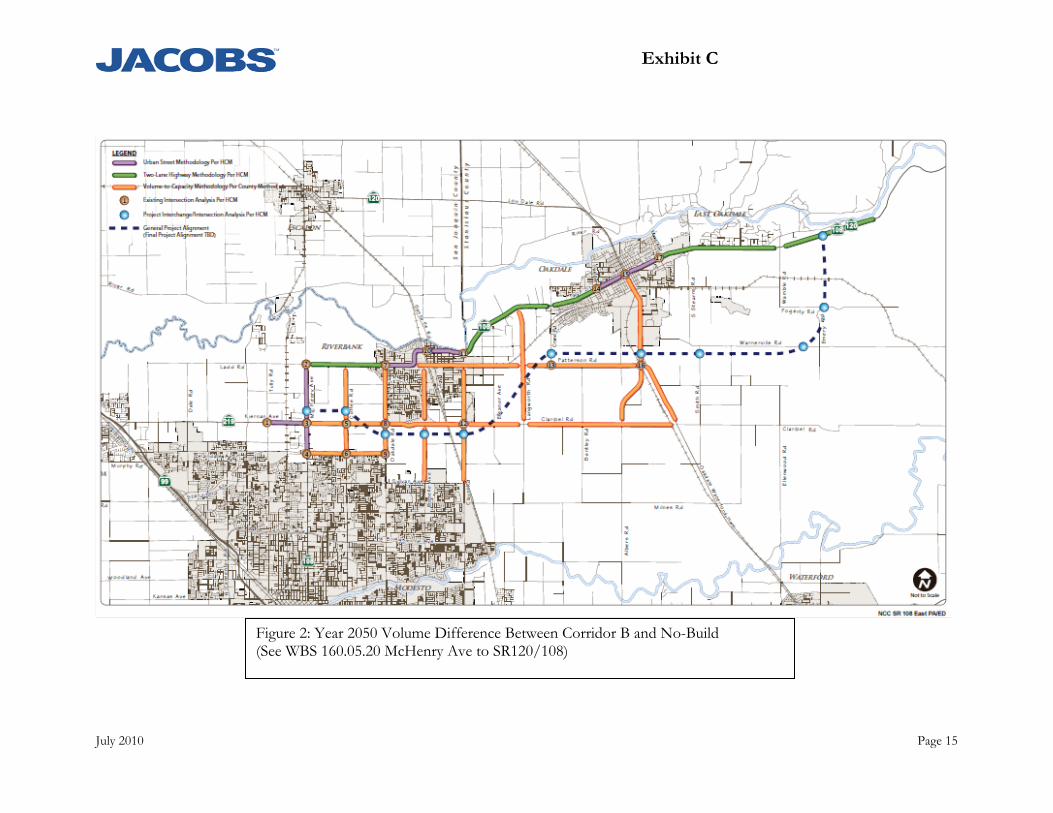
Exhibit C
July 2010 Page 15
Figure 2: Year 2050 Volume Difference Between Corridor B and No-Build
(See WBS 160.05.20 McHenry Ave to SR120/108)
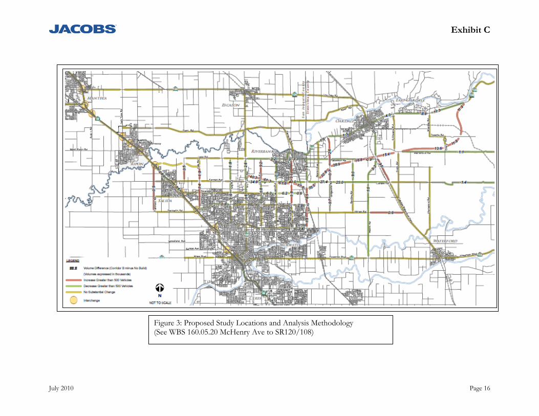
Exhibit C
July 2010 Page 16
Figure 3: Proposed Study Locations and Analysis Methodology (See WBS 160.05.20 McHenry Ave to SR120/108)
Exhibit C-A3
November 2011 Page 17
Deliverables Data Collection Report
WBS 160.05.25 - Review Geometrics and Project Alternatives (SR99 to SR120/108) Jacobs team will work with the Project Team to review and refine up to three Project Alternatives. It is anticipated that the major focus of this task will involve identifying the most appropriate alignment for each of the Project Alternatives and the traffic control that would be necessary at each crossing with an existing or future roadway.
Review Geometrics and Project Alternatives (McHenry Ave to SR120/108) (WBS 160.05.25) Jacobs team will work with the Project Team to review and refine up to three Project Alternatives.
Traffic Forecasting (WBS 160.10.10)
Scope of Services:
WBS 160.10.10 – Prepare Traffic Forecasts (SR99 to SR120/108) The model developed as part of the recently updated 2011StanCOG Regional Transportation Plan (RTP) will be used to develop traffic forecasts. As requested by Caltrans, a focused daily model validation/calibration exercise will be undertaken in the study area.. Prior to developing traffic forecasts Jacobs team will work with the project team to identify the appropriate roadway network and land use assumptions to use in the analysis. A technical memorandum will be prepared that summarizes all of the assumptions for review and approval by the PDT. Opening year and design year traffic daily forecasts will be developed for up to five alternatives including No Build conditions. A detailed analysis (PA/ED) for the section of the corridor between McHenry Avenue and SR 120/108 east of Oakdale is being performed under a separate work scope. For this reason, this work scope will not focus on sizing the corridor between McHenry Avenue and SR 120/SR 108. Instead this work scope will focus on identifying an appropriate planning level footprint for the intersections and interchanges along the corridor between SR 99 and McHenry Avenue. Design hour turning movement forecasts will be determined for each intersection and/or interchange along the corridor between SR 99 and McHenry Avenue. The design hour turning movement forecasts will be determined by multiplying the daily turning movement forecasts by a factor of 10.0% (per Caltrans direction). Jacobs team will submit a technical memorandum summarizing the traffic forecasts for review and approval by the PDT. Once approved, Jacobs team will proceed with the technical evaluation of the alternatives. Twelve traffic corridors have been identified as of April 2011. A travel demand modeling sensitivity analysis will be performed to technically demonstrate that some of the traffic corridors would yield similar traffic results. The sensitivity analysis will be used to condense several of the traffic corridors into a single traffic alternative. As an example, traffic corridor #2 and #3 would be modeled and compared to the raw model volumes. If the raw model volumes are similar then the traffic corridors #2 and #3 can be condensed into a single traffic alternative.
WBS 160.10.10 – Prepare Traffic Forecasts (McHenry Ave to SR120/108) The RTP model used to develop daily traffic forecasts will be used to determine opening year and design year intersection and roadway segment peak hour traffic volumes. A focused peak hour model validation exercise will be undertaken in the study area, followed by the use of the model to predict changes in travel patterns in the opening and
Exhibit C-A3
November 2011 Page 18
design year time period. A calibration/validation memorandum will be developed that presents initial model validation procedures and results, to be reviewed with Caltrans. If the model does not meet the specified Caltrans targets, we will work to improve the validation results by adjusting link characteristics and conducting select link analyses to ensure reasonable movements through the project area. Jacobs team will review the results with Caltrans and if the revised model meets the specified validation target we will proceed with the future year forecasting. However, if the revised model still does not fully meet all of the targets, Jacobs team will review the progress made with Caltrans and request approval to proceed with forecasting. Opening year and design year traffic forecasts (intersection and roadway) will be developed for up to four alternatives including No Build conditions. Jacobs team will submit a technical memorandum summarizing the traffic forecasts for review and approval by the PDT. Once approved, Jacobs team will proceed with the technical evaluation of the alternatives.
Deliverables: Traffic Forecasting Calibration/Validation Memorandum
Draft and Final Traffic Forecasting Technical Memorandum
Assumptions: All deliverables will be subject to one review cycle by Caltrans and the JPA
It is assumed that the 12 traffic corridors (SR 120 to SR 120/108) can be condensed into 4 traffic alternatives and the model sensitivity tests will illustrate the following:
Traffic corridors 1,4 and 7 can be condensed into a single traffic alternative
Traffic corridors 2, 3, 5, 6, 8, and 9 can be condensed into a single traffic alternative
Traffic corridor 10 is its own traffic alternative
Traffic corridors 11 and 12 can be condensed into a single traffic alternative
Upon selection of the final traffic corridor (preferred alternative) from the 12 potential corridors, up to three first phase (McHenry Avenue to SR 120/108) project alternatives will be developed that follow the alignment of the final traffic corridor for developing peak hour traffic forecasts.
Geometric Plans for Project Alternatives (WBS 160.10.15)
Geometric plans for the Draft Project Report will include three (3) alignment alternatives. Plans shall be prepared at 1” = 300’ scale (approximately 1” = 500’ for reduced plans). Appropriate dimensions and features to the design will be labeled. Includes layout plans and typical sections, and CT design geometric review checklist.
Right-of-Way requirements will be shown. Retaining wall and sound wall locations will be shown with approximate heights. Daylight limits of standard slopes will be delineated.
Exhibit C-A3
November 2011 Page 19
Profiles and superelevation diagrams will be provided for the mainline, interchange ramps and cross streets for the three alternatives.
Deliverables: Geometric plans for three alignment alternatives, includes layout plans (300 scale), typical
sections, profile & supers.
Assumptions: All deliverables will be subject to one review cycle by Caltrans and the JPA
Assume two (2) alignment Alternatives from SR 99 to Yosemite Avenue, with three (3) alignment variations at east connection to SR 120 resulting in a total of six project Alternatives (1A, 1B, 1C, 2A, 2B, and 2C) for study in the Draft Environmental Document.
For Alternatives 1A, 1B, and 1C: 4-lane freeway/expressway, with 50-foot local road easements for future frontage/access roads on both sides, with no frontage design or details. Use planned SR 99/Hammett Interchange Layout plans and Right of Way design by others. No freeway-to-freeway connector design at SR 99. Typical sections presented to the Project Development Team dated 5/18/11 will be used.
For Alternatives 2A, 2B, and 2C: 4-lane freeway/expressway, with 50-foot easements for future frontage/access roads on both sides, no frontage road design or details. Use planned SR 99/Hammett Interchange Layout plans and Right of Way design by others. Nor freeway-to-freeway connector design at SR 99. Typical sections presented to the Project Development Team dated 5/18/11 will be used.
IC locations planned as shown on IC Location Map dated May 13, 2011 and approved by
JPA staff. Assume no changes to IC locations that would cause a change to study area ESL maps.
Cross-over connection Alternative(s) or option(s) between Alt 1 and Alt 2 (i.e., using portion for Alt 1 and combination with a portion for Alt 2) may be needed, but will be determined at a later date with PDT concurrence. The additional work effort and cost (Design, Environmental, Traffic, etc) will be defined at that time for JPA review and approval.
No additional design work on the initial Design Options Assume no new Alignment Options to be considered during DED JPA staff will manage public requests for design changes during DED development.
Assume no changes that would cause changes to study area ESL maps.
Determine Right-of-Way Requirements (WBS 160.10.15)
Scope of Services: Determine Right-of-Way requirements for each project alternative. Right-of-Way
requirements will be established in Microstation map format and tabulated in Excel spreadsheet with parcel number identification and area of take required. This information
Exhibit C-A3
November 2011 Page 20
will be used to prepare the RW Data Sheets and to evaluate RW impact & RW cost for each alternative.
Deliverables: Tabulated Right-of-Way Requirements (excel spreadsheet) and Right-of-Way Requirements
Maps for each alternative.
Assumptions: For estimating purposes, the Right-of-Way Requirements will be for 3 alignment alternatives
All deliverables will be subject to one review cycle by Caltrans and the JPA
Utility Location Requirements (WBS 160.10.15)
Scope of Services: Research all utility information available from utility owners, public records, and other sources. This
information will be transferred to Microstation CADD design file to become a utility reference for preliminary planning and engineering.
Work with Caltrans, USA One-call Center, and the public and private utility companies to determine all utility owners located in or near the project alternatives
Determine and record utility owner key contacts; including engineers, technician, and utility locator personnel or contractors.
Prepare and communicate general project information, as approved by project management, to utility owners. In return, obtain utility as-builts, maps, schematics, and (or) CADD drawings from the utility owners.
Submit preliminary summary reports of all subsurface utilities in the corridor. Prepare CADD drawings with research information. Include variables along with approximate location; such as utility carriage, pipe size, material, and age.
Deliverables: Utility record drawings and contact list
Utility base mapping
Assumptions: All utilities are assumed to need relocation. The notable exceptions are the Hetch Hetchy
water and power systems and irrigation district facilities.
Potholing of existing utilities is not included in the work program at this stage of the project.
60% Design Plans for Constructible Segment (WBS 160.10.16)
Scope of Services: Prepare 60% design plans for the preferred alternative Programmable constructible segment.
The phasing plans will be prepared at 1” = 50’ scale (approximately 1” = 100’ for reduced plans).
Exhibit C-A3
November 2011 Page 21
Prepare 60% plan set for the initial construction phase that will include: Title Sheet, typical sections, layouts, preliminary striping, profiles and superelevations, drainage layout plans, existing utility plans, and APS sheets. In addition, an updated construction cost estimate will be included.
Deliverables: 60% Design plans and cost estimate for one alternative
Assumptions: 60% plans for 2-lane roadway with at-grade intersections and no ICs from SR120 to
McHenry
All deliverables will be subject to one review cycle by Caltrans and the JPA
Drainage layout plans will be limited to preliminary sizing and profiles.
Value Analysis (WBS 160.10.20)
Scope of Services: Conduct a Value Analysis (VA) Study to comply with the National Highway System (NHS) VE
mandate and follow the Caltrans VA methodology as outlined in the Chapter 19, “Value Analysis” of the Project Development Procedures Manual (PDPM) and detailed in the Caltrans VA Team Guide and Report Guide.
Provide on site team leadership and final report documentation for a six (6) day project studies.
Provide a qualified, independent Certified Value Specialist (CVS), certified by SAVE International and a registered Professional Engineer (PE) with civil/transportation engineering background.
Provide VA study documentation in accordance with the Caltrans VA Report Guide.
Provide 6-8 additional team members with specific expertise to serve as members of a VA team. This selection of team members will be coordinated with Caltrans and the JPA. The potential team members may include the following disciplines:
o Highway Design o Traffic Design o Traffic Analysis o Hydraulic Design o Structural Design o Construction Staging o Construction o Environmental Planning o Other team members to be provided by stakeholder agencies
Deliverables: Draft and Final VA Reports

Exhibit C-A3
November 2011 Page 22
Assumptions: Facility for the VA study to be provided by the JPA
Hydraulics/Hydrology Studies (WBS 160.10.25)
Scope of Services: A hydrology study will be performed based on gross acreage determinations tributary to the
proposed drainage systems shown on the Drainage Concept Plans. The analysis will be based on a cfs/acre basis, developed for the differing land uses. A qualitative assessment will be made for existing cross drainage systems to assess its extension through the project.
Deliverables: Hydrology Study
Assumptions: A detailed hydrology and hydraulic analysis is typically not needed for a PA & ED, and
therefore not included in the scope of work.
Drainage Concept Plans (WBS 160.10.25)
Scope of Services: Drainage facilities for the preferred alternative will be evaluated and identified in a qualitative
manner. Preliminary profiles will be provided. For determining the extent of drainage improvements, we will identify critical locations for drainage concentration points and develop conveyance systems to accommodate the locations. Rough estimates of design discharges will be developed on gross acreage determinations of tributaries to the proposed drainage systems on a cfs/acre basis. These values will be used to provide preliminary sizing of the drainage systems within the project site. The capacity of existing storm drain systems will be estimated using normal depth calculations to determine if the existing facilities have adequate capacity to accommodate increase in storm water run off resulting from the project.
Deliverables: Concept Drainage Plans (Layout only)
All deliverables will be subject to one review cycle by Caltrans and the JPA
Storm Water Data Report (WBS 160.10.25)
Scope of Services: In accordance with the Caltrans Project Planning and Design Guide dated May 2007, a
Storm Water Data Report (SWDR) shall be prepared.
The SWDR is to include the following information: Project description, identification of the receiving water bodies, geotechnical information, design pollution prevention and post-

Exhibit C-A3
November 2011 Page 23
construction BMPs proposed, costs, and checklists. Phased construction shall be considered in the report.
The SWDR will be signed by the Project Engineer and then submitted to JPA and Caltrans for review and approval by the District/Regional Design Storm Water Coordinator, the designated Caltrans Landscape Representative, the designated Caltrans Maintenance Representative, and final approval by the Caltrans Project Manager to verify that storm water quality design issues have been addressed, and the data is complete, and accurate.
The SWDR will be prepared and revised at the Draft and Final PR phases.
Deliverables: Storm Water Data Report (Draft and Final)
Assumptions: The SWDR will be prepared for a single alternative (preferred) as there is not a significant
differential impact to the main water bodies between the alternatives. Two reviews (three submittals) are assumed for both the Draft and Final SWDR.
Traffic Operational Analysis (WBS 160.10.35)
Scope of Services: WBS 160.10.35 – Perform Daily Volume to Capacity Analysis (SR99 to SR120/108)
The daily traffic counts will be used to determine existing level of service (LOS) for the same roadway locations identified in WBS 160.05.20. The final daily level of service thresholds and volume to capacity ratios used for the SR 108 East Project will be used for this study. The daily level of service thresholds are presented in the table below and can be modified based on input from the Project Team including Caltrans.
Daily Capacity (vehicles per lane)
Facility 2 lanes 4 lanes 6 lanes 8 lanes
Freeway 22,000 22,000 22,000
Class A Expressway 15,000 15,000 15,000
Class B Expressway 12,500 12,500 12,500
Class C Expressway 10,000 10,000 10,000
Majors 10,000 9,000 9,000
Collectors 5,000 5,000 This scope assumes that the existing data and analysis prepared for the SR 108 East Project can be used for this study. No new existing conditions analysis will be performed.
The traffic forecasts developed under WBS 160.10.10 will be used to evaluate the study roadway locations for up to five alternatives including No Build conditions. Changes in ADT and level of service as a result of the Project will be determined. In addition, the number of lanes on the North County Corridor to provide acceptable service levels will also be determined. Furthermore, the regional implications of the corridor will also be evaluated by examining additional measures of effectiveness (MOEs) such as vehicle
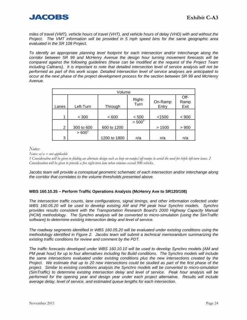
Exhibit C-A3
November 2011 Page 24
miles of travel (VMT), vehicle hours of travel (VHT), and vehicle hours of delay (VHD) with and without the Project. The VMT information will be provided in 5 mph speed bins for the same geographic area evaluated in the SR 108 Project.
To identify an appropriate planning level footprint for each intersection and/or interchange along the corridor between SR 99 and McHenry Avenue the design hour turning movement forecasts will be compared against the following guidelines (these can be modified at the request of the Project Team including Caltrans). It is important to note that detailed intersection level of service analysis will not be performed as part of this work scope. Detailed intersection level of service analyses are anticipated to occur at the next phase of the project development process for the section between SR 99 and McHenry Avenue.
Volume
Lanes Left-Turn Through
Right-Turn
On-Ramp Entry
Off-Ramp Exit
1 < 300 < 600 < 500 <1500 < 900
2 300 to 600 600 to 1200 > 5002
> 1500 > 900
3 > 6001
1200 to 1800 n/a n/a n/a Notes: Notes: n/a = not applicable 1 Consideration will be given to finding an alternate design such as loop on-ramps/off-ramps to avoid the need for triple left-turn lanes. 2 Consideration will be given to provide a free right-turn lane when volumes exceed 500 vehicles. Jacobs team will provide a conceptual geometric schematic of each intersection and/or interchange along the corridor that correlates to the volume thresholds presented above.
WBS 160.10.35 – Perform Traffic Operations Analysis (McHenry Ave to SR120/108)
The intersection traffic counts, lane configurations, signal timings, and other information collected under WBS 160.05.20 will be used to develop existing AM and PM peak hour Synchro models. Synchro provides results consistent with the Transportation Research Board’s 2000 Highway Capacity Manual (HCM) methodology. The Synchro analysis will be converted to micro-simulation (using the SimTraffic software) to determine existing intersection delay and level of service. The roadway segments identified in WBS 160.05.20 will be evaluated under existing conditions using the methodology identified in Figure 2. Jacobs team will submit a technical memorandum summarizing the existing traffic conditions for review and comment by the PDT.
The traffic forecasts developed under WBS 160.10.10 will be used to develop Synchro models (AM and PM peak hour) for up to four alternatives including No Build conditions. The Synchro models will include the same intersections evaluated under existing conditions plus the new intersections created by the Project. We estimate that up to 20 new intersections could be studied as part of the first phase of the project. Similar to existing conditions analysis the Synchro models will be converted to micro-simulation (SimTraffic) to determine existing intersection delay and level of service. Peak hour analysis will be performed for the opening year and design year under each project alternative. Results will include average delay, level of service, and estimated queue lengths for each intersection.
Exhibit C-A3
November 2011 Page 25
The roadway segments identified in WBS 160.05.20 will be evaluated under opening year and design year conditions using the methodology identified in Figure 2.
The design of the facility has not yet been established. It can potentially be a two-lane highway, a multi-lane highway, or expressway with grade separated interchanges. Depending on the final design of the project Jacobs team may perform one of the following:
AM and PM peak hour two-lane highway analysis or AM and PM peak hour multi-lane highway analysis
The mainline analysis will be consistent with the methodologies presented in the 2000 HCM. Weaving analysis, if necessary, will be consistent with the methodologies presented in Chapter 500 (Leisch Method) of the Caltrans Highway Design Manual (HDM).
In addition to peak hour level of service analysis, Jacobs team will utilize the modified StanCOG RTP Model to project peak hour volume changes on project area roadways as a result of the Project. Furthermore, the regional implications of the corridor will also be evaluated by examining additional measures of effectiveness (MOEs) such as vehicle miles of travel (VMT), vehicle hours of travel (VHT), and vehicle hours of delay (VHD) with and without the Project. The VMT information will be provided in 5 mph speed bins.
Deliverables: Existing Traffic Conditions Technical Memorandum
Assumptions: For the first phase analysis (McHenry to SR 120/108), the number of existing study
intersections is 17 and the number of new intersections created by the project is less than 20, the number of existing roadway segments is 33, and the number of alternatives studied equals 4, including the no build alternative.
For the future buildable segment analysis (SR 99 to SR 120/108) the number of study roadway segments is 107 and are the same as the NCC East Route Adoption, and the number of alternatives studied equals 5, including the no build alternative.
All deliverables will be subject to one review cycle by Caltrans and the JPA
Right-of-Way Data Sheet (WBS 160.10.40)
Scope of Services: Prepare Right-of-Way Data Sheet(s) in accordance with the Caltrans Right-of-Way Manual for each alignment alternative including the following information:
Right-of-Way (ROW) Cost Estimate
Parcel Data
Utility Facility Conflicts
Railroad Facility Conflicts
Identification of previously unidentified hazardous materials
Displacement requirements
Borrow or Disposal Sites required

Exhibit C-A3
November 2011 Page 26
Potential relinquishments and/or abandonment’s
Existing and/or potential Airspace sites
Estimated ROW schedule and lead time
Deliverables: Right-of-Way Data Sheet(s)
Assumptions: All deliverables will be subject to one review cycle by Caltrans and the JPA
Railroad Study (WBS 160.10.50)
Scope of Services: Identify impacted rail lines, including Burlington Northern- Santa Fe Railroad, Union
Pacific-Southern Pacific Railroad and Sierra Railroad, operation requirements and expansion plans and prepare a Railroad Information Sheet in accordance with Exhibit 4-EX-1 (REV March 2004) of the Caltrans Right-of-Way Manual (updated March 2007) for the Project Record describing the railroad facilities and types of agreements and right of way required from the railroads.
Deliverables: Railroad Information Sheet
Assumptions: All deliverables will be subject to one review cycle by Caltrans and the JPA
Park and Ride Study (WBS 160.10.60)
Scope of Services: Assess the potential to add park-and-ride facilities within the project corridor for the
preferred alternative. Potential locations for park-and-ride facilities will be limited to areas adjacent to existing local access interchanges that are served by or are near existing bus service. Particular focus will be given to (but not limited to) property remainders after acquisitions or associated street modifications. Locations will be recommended (if any) and the approximate number of spaces will be determined. Park-and-ride lot layouts are not included in the scope at this phase of the project.
Deliverables: Draft and final Park and Ride Study
Assumptions: All deliverables will be subject to one review cycle by Caltrans and the JPA
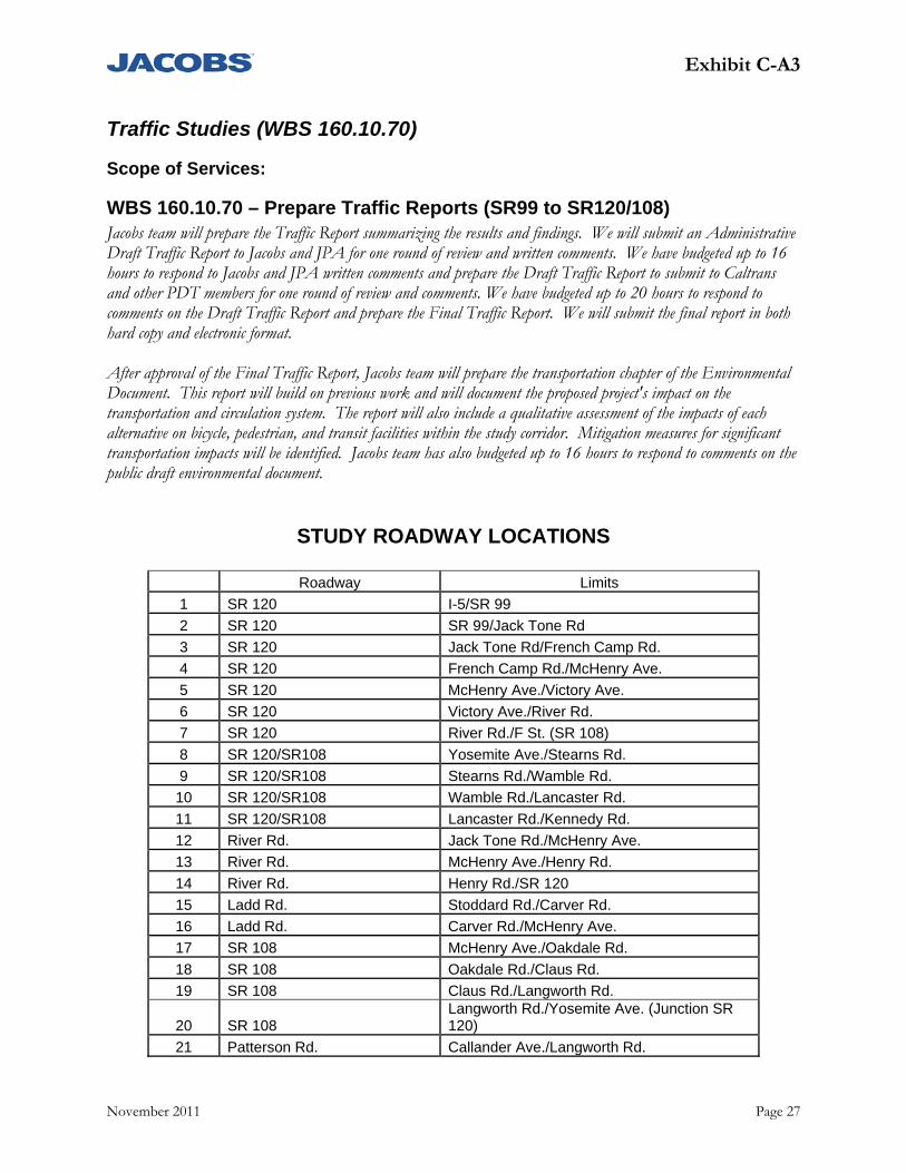
Exhibit C-A3
November 2011 Page 27
Traffic Studies (WBS 160.10.70)
Scope of Services:
WBS 160.10.70 – Prepare Traffic Reports (SR99 to SR120/108) Jacobs team will prepare the Traffic Report summarizing the results and findings. We will submit an Administrative Draft Traffic Report to Jacobs and JPA for one round of review and written comments. We have budgeted up to 16 hours to respond to Jacobs and JPA written comments and prepare the Draft Traffic Report to submit to Caltrans and other PDT members for one round of review and comments. We have budgeted up to 20 hours to respond to comments on the Draft Traffic Report and prepare the Final Traffic Report. We will submit the final report in both hard copy and electronic format. After approval of the Final Traffic Report, Jacobs team will prepare the transportation chapter of the Environmental Document. This report will build on previous work and will document the proposed project's impact on the transportation and circulation system. The report will also include a qualitative assessment of the impacts of each alternative on bicycle, pedestrian, and transit facilities within the study corridor. Mitigation measures for significant transportation impacts will be identified. Jacobs team has also budgeted up to 16 hours to respond to comments on the public draft environmental document.
STUDY ROADWAY LOCATIONS
Roadway Limits
1 SR 120 I-5/SR 99
2 SR 120 SR 99/Jack Tone Rd
3 SR 120 Jack Tone Rd/French Camp Rd.
4 SR 120 French Camp Rd./McHenry Ave.
5 SR 120 McHenry Ave./Victory Ave.
6 SR 120 Victory Ave./River Rd.
7 SR 120 River Rd./F St. (SR 108)
8 SR 120/SR108 Yosemite Ave./Stearns Rd.
9 SR 120/SR108 Stearns Rd./Wamble Rd.
10 SR 120/SR108 Wamble Rd./Lancaster Rd.
11 SR 120/SR108 Lancaster Rd./Kennedy Rd.
12 River Rd. Jack Tone Rd./McHenry Ave.
13 River Rd. McHenry Ave./Henry Rd.
14 River Rd. Henry Rd./SR 120
15 Ladd Rd. Stoddard Rd./Carver Rd.
16 Ladd Rd. Carver Rd./McHenry Ave.
17 SR 108 McHenry Ave./Oakdale Rd.
18 SR 108 Oakdale Rd./Claus Rd.
19 SR 108 Claus Rd./Langworth Rd.
20 SR 108 Langworth Rd./Yosemite Ave. (Junction SR 120)
21 Patterson Rd. Callander Ave./Langworth Rd.
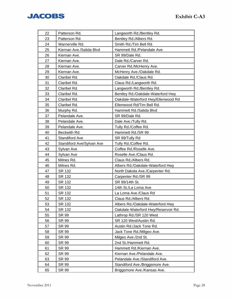
Exhibit C-A3
November 2011 Page 28
22 Patterson Rd. Langworth Rd./Bentley Rd.
23 Patterson Rd. Bentley Rd./Albers Rd.
24 Warnerville Rd. Smith Rd./Tim Bell Rd.
25 Kiernan Ave./Salida Blvd Hammett Rd./Pelandale Ave
26 Kiernan Ave. SR 99/Dale Rd.
27 Kiernan Ave. Dale Rd./Carver Rd.
28 Kiernan Ave. Carver Rd./McHenry Ave.
29 Kiernan Ave. McHenry Ave./Oakdale Rd.
30 Claribel Rd. Oakdale Rd./Claus Rd.
31 Claribel Rd. Claus Rd./Langworth Rd.
32 Claribel Rd. Langworth Rd./Bentley Rd.
33 Claribel Rd. Bentley Rd./Oakdale-Waterford Hwy
34 Claribel Rd. Oakdale-Waterford Hwy/Ellenwood Rd
35 Claribel Rd. Ellenwood Rd/Tim Bell Rd.
36 Murphy Rd. Hammett Rd./Salida Blvd
37 Pelandale Ave. SR 99/Dale Rd.
38 Pelandale Ave. Dale Ave./Tully Rd.
39 Pelandale Ave. Tully Rd./Coffee Rd.
40 Beckwith Rd. Hammett Rd./SR 99
41 Standiford Ave SR 99/Tully Rd
42 Standiford Ave/Sylvan Ave Tully Rd./Coffee Rd.
43 Sylvan Ave Coffee Rd./Roselle Ave.
44 Sylvan Ave Roselle Ave./Claus Rd.
45 Milnes Rd. Claus Rd./Albers Rd.
46 Milnes Rd. Albers Rd./Oakdale-Waterford Hwy
47 SR 132 North Dakota Ave./Carpenter Rd.
48 SR 132 Carpenter Rd./SR 99
49 SR 132 SR 99/14th St.
50 SR 132 14th St./La Loma Ave
51 SR 132 La Loma Ave./Claus Rd
52 SR 132 Claus Rd./Albers Rd.
53 SR 132 Albers Rd./Oakdale-Waterford Hwy
54 SR 132 Oakdale-Waterford Hwy/Reservoir Rd.
55 SR 99 Lathrop Rd./SR 120 West
56 SR 99 SR 120 West/Austin Rd.
57 SR 99 Austin Rd./Jack Tone Rd.
58 SR 99 Jack Tone Rd./Milgeo Ave.
59 SR 99 Milgeo Ave./2nd St.
60 SR 99 2nd St./Hammett Rd.
61 SR 99 Hammett Rd./Kiernan Ave.
62 SR 99 Kiernan Ave./Pelandale Ave.
63 SR 99 Pelandale Ave./Standiford Ave.
64 SR 99 Standiford Ave./Briggsmore Ave.
65 SR 99 Briggsmore Ave./Kansas Ave.
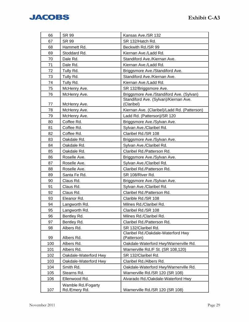
Exhibit C-A3
November 2011 Page 29
66 SR 99 Kansas Ave./SR 132
67 SR 99 SR 132/Hatch Rd.
68 Hammett Rd. Beckwith Rd./SR 99
69 Stoddard Rd. Kiernan Ave./Ladd Rd.
70 Dale Rd. Standiford Ave./Kiernan Ave.
71 Dale Rd. Kiernan Ave./Ladd Rd.
72 Tully Rd. Briggsmore Ave./Standiford Ave.
73 Tully Rd. Standiford Ave./Kiernan Ave.
74 Tully Rd. Kiernan Ave./Ladd Rd.
75 McHenry Ave. SR 132/Briggsmore Ave.
76 McHenry Ave. Briggsmore Ave./Standiford Ave. (Sylvan)
77 McHenry Ave. Standiford Ave. (Sylvan)/Kiernan Ave. (Claribel)
78 McHenry Ave. Kiernan Ave. (Claribel)/Ladd Rd. (Patterson)
79 McHenry Ave. Ladd Rd. (Patterson)/SR 120
80 Coffee Rd. Briggsmore Ave./Sylvan Ave.
81 Coffee Rd. Sylvan Ave./Claribel Rd.
82 Coffee Rd. Claribel Rd./SR 108
83 Oakdale Rd. Briggsmore Ave./Sylvan Ave.
84 Oakdale Rd. Sylvan Ave./Claribel Rd.
85 Oakdale Rd. Claribel Rd./Patterson Rd.
86 Roselle Ave. Briggsmore Ave./Sylvan Ave.
87 Roselle Ave. Sylvan Ave./Claribel Rd.
88 Roselle Ave. Claribel Rd./Patterson Rd.
89 Santa Fe Rd. SR 108/River Rd.
90 Claus Rd. Briggsmore Ave./Sylvan Ave.
91 Claus Rd. Sylvan Ave./Claribel Rd.
92 Claus Rd. Claribel Rd./Patterson Rd.
93 Eleanor Rd. Clarible Rd./SR 108
94 Langworth Rd. Milnes Rd./Claribel Rd.
95 Langworth Rd. Claribel Rd./SR 108
96 Bentley Rd. Milnes Rd./Claribel Rd.
97 Bentley Rd. Claribel Rd./Patterson Rd.
98 Albers Rd. SR 132/Claribel Rd.
99 Albers Rd. Claribel Rd./Oakdale-Waterford Hwy (Patterson)
100 Albers Rd. Oakdale-Waterford Hwy/Warnerville Rd.
101 Albers Rd. Warnerville Rd./F St. (SR 108,120)
102 Oakdale-Waterford Hwy SR 132/Claribel Rd.
103 Oakdale-Waterford Hwy Claribel Rd./Albers Rd.
104 Smith Rd. Oakdale-Waterford Hwy/Warnerville Rd.
105 Stearns Rd. Warnerville Rd./SR 120 (SR 108)
106 Ellenwood Rd. Alvarado Rd./Oakdale-Waterford Hwy
107 Wamble Rd./Fogarty Rd./Emery Rd. Warnerville Rd./SR 120 (SR 108)
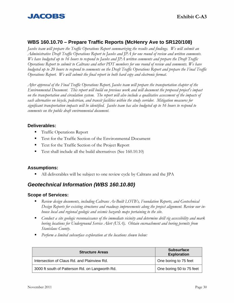
Exhibit C-A3
November 2011 Page 30
WBS 160.10.70 – Prepare Traffic Reports (McHenry Ave to SR120/108) Jacobs team will prepare the Traffic Operations Report summarizing the results and findings. We will submit an Administrative Draft Traffic Operations Report to Jacobs and JPA for one round of review and written comments. We have budgeted up to 16 hours to respond to Jacobs and JPA written comments and prepare the Draft Traffic Operations Report to submit to Caltrans and other PDT members for one round of review and comments. We have budgeted up to 20 hours to respond to comments on the Draft Traffic Operations Report and prepare the Final Traffic Operations Report. We will submit the final report in both hard copy and electronic format. After approval of the Final Traffic Operations Report, Jacobs team will prepare the transportation chapter of the Environmental Document. This report will build on previous work and will document the proposed project's impact on the transportation and circulation system. The report will also include a qualitative assessment of the impacts of each alternative on bicycle, pedestrian, and transit facilities within the study corridor. Mitigation measures for significant transportation impacts will be identified. Jacobs team has also budgeted up to 16 hours to respond to comments on the public draft environmental document.
Deliverables: Traffic Operations Report
Text for the Traffic Section of the Environmental Document
Text for the Traffic Section of the Project Report
Text shall include all the build alternatives (See 160.10.10)
Assumptions: All deliverables will be subject to one review cycle by Caltrans and the JPA
Geotechnical Information (WBS 160.10.80)
Scope of Services: Review design documents, including Caltrans As-Built LOTB’s, Foundation Reports, and Geotechnical
Design Reports for existing structures and roadway improvements along the project alignment. Review our in-house local and regional geologic and seismic hazards maps pertaining to the site.
Conduct a site geologic reconnaissance of the immediate vicinity and determine drill rig accessibility and mark boring locations for Underground Service Alert (USA). Obtain encroachment and boring permits from Stanislaus County.
Perform a limited subsurface exploration at the locations shown below:
Structure Areas Subsurface Exploration
Intersection of Claus Rd. and Plainview Rd. One boring to 75 feet
3000 ft south of Patterson Rd. on Langworth Rd. One boring 50 to 75 feet

Exhibit C-A3
November 2011 Page 31
Intersection of Patterson Rd. and Oakdale Waterford Hwy. One boring to 75 feet
Intersection of Warnerville Rd. and S. Stearns Rd. One boring to 50 feet
2000 ft east of Stoddard Rd. on Warnerville Rd. One boring 50 feet
4000 ft southwest of Lancaster Rd. and OID* south main canal intersection.
One boring to 50 feet
*OID-Oakdale Irrigation District Borings can be located off of the existing roadways and that traffic control at most will consist of safety
signs/cones for shoulder work without flagmen.
Perform the following laboratory tests on relatively undisturbed samples obtained from the exploratory borings: o Moisture Content and Unit Weight o Triaxial Compression for bearing capacity and lateral pile capacity o Sieve analysis o Plasticity Index o Soil corrosivity
Prepare Preliminary Foundation Memos for the project which will include the following: o Summary of Site Geology and Subsurface Conditions o Project Location o As-Built Log of Test Borings for Existing Nearby Structures o Log of Test Borings for our Preliminary Subsurface Exploration o Preliminary Seismic Data and Evaluation (including ARS curve) o Preliminary Liquefaction Evaluation o Preliminary Corrosion Evaluation o Preliminary Foundation Recommendations o Evaluation of embankment settlement, cut/fill slope stability, scour, soil corrosivity, and
constructability issues o Recommendations for Additional Field Work and Laboratory Testing
Deliverables: Draft Preliminary Foundation Memo (Type Selection) – Claus Road/Mid Main Canal, and
McGee Avenue/Claribel Structures
Draft Preliminary Foundation Memo (Type Selection) – Langworth Road, Bentley Road, Kaufman Road, Patterson Road, Albers/Brichetto, and Claribel/South Lateral Structures
Draft Preliminary Foundation Memo (Type Selection) – OID South Main, Union, and Kearnic Laterals
Draft Preliminary Foundation Memo (Type Selection) – Sierra RR and OID South Main Structure
Final Preliminary Foundation Memo (Type Selection) – Claus Road/Mid Main Canal, and McGee Avenue/Claribel Structures
Final Preliminary Foundation Memo (Type Selection) – Langworth Road, Bentley Road, Kaufman Road, Patterson Road, Albers/Brichetto, and Claribel/South Lateral Structures
Exhibit C-A3
November 2011 Page 32
Final Preliminary Foundation Memo (Type Selection) – OID South Main, Union, and Kearnic Laterals
Final Preliminary Foundation Memo (Type Selection) – Sierra RR and OID South Main Structure
Assumptions: We assume the County will waive the encroachment permit fee.
The preliminary Foundation Memo should only be used for advanced planning as additional subsurface exploration; laboratory testing and analysis will be required to prepare Final Foundation Reports for design of each bridge.
All deliverables will be subject to one review cycle by Caltrans and the JPA
Preliminary GDR/Materials Report (WBS 160.10.80)
Scope of Services: Review documents provided by the design team, including Caltrans As-Built LOTB’s, Foundation Reports,
and Geotechnical Design Reports for existing structures and roadway improvements along the project alignment. To evaluate site geology and seismic conditions, we will review our in-house local and regional geologic and seismic hazards maps pertaining to the site.
Perform R-value testing on relatively undisturbed samples obtained during our preliminary foundation memo exploration.
Prepare a Preliminary Geotechnical/Materials Report for the project alignment including the following: o Project description o Summary of site geology and subsurface conditions o As-built LOTB for existing structures along the alignment o LOTBs for our limited subsurface exploration o Discussion of potential geotechnical/material issues for design o Preliminary pavement sections.
Deliverables: Draft Preliminary Geotechnical/Material Report
Final Preliminary Geotechnical/Materials Report
Assumptions: All deliverables will be subject to one review cycle by Caltrans and the JPA
The preliminary Geotechnical/Materials Report should only be used for advanced planning as additional subsurface exploration; laboratory testing and analysis will be required to prepare Final Geotechnical and Material Design Reports for the proposal improvements.
Exhibit C-A3
November 2011 Page 33
Structure Advance Planning Study (APS) (WBS 160.10.85)
Scope of Services: Based on the proposed roadway geometrics and preliminary project information, the APS will be prepared in
accordance to the Caltrans’ Office of Special Funded Project Procedures Guide. As part of the APS tasks, a feasible type of structure will be developed with associated cost appropriate for the specific location. The preliminary foundation report and the structure foundations will be reviewed to determine preliminary foundation type. A review the preliminary hydraulic report and coordination with the project hydraulic engineer as required to develop the proper structure layout to meet the requirements in the report will be performed. These APS will be used to develop structure costs and impacts for all the alternative alignments. Deliverables:
APS Report per bridge includes: a bridge APS exhibit, APS Checklist, an APS design memo, and Itemized cost estimates consistent with Project Report requirements.
Assumptions: All deliverables will be subject to one review cycle by Caltrans and the JPA
APS will not be prepared for each of the structures within the corridor but will be for those structures that will be a representative of a group type as mutually agreed upon. In general, the structures will be grouped as follows:
o Canal Crossings o Undercrossings o Overcrossings o Overheads o 3 additional unique structures.
No preliminary hydraulic report will be required for the canal crossings.
Preliminary Transportation Management Plan (WBS 160.10.95)
Scope of Services: The preliminary Transportation Management Plan (TMP) and corresponding worksheets
will be developed for each of the three project alternatives based on Caltrans current guidelines.
Deliverable: Preliminary TMP
Cost Estimates for Alternatives (WBS 160.15.05)
Provide cost estimates for three (3) alternatives based on Caltrans Project Development Procedures Manual guidelines for Project Report cost estimates. An independent review by JPA of the cost estimates will be performed.
Exhibit C-A3
November 2011 Page 34
Deliverables: Project Report Cost Estimates
Fact Sheet for Exceptions to Design Standards (WBS 160.15.10)
Scope of Services: Identify all non-standard design features based on the Design Checklist (DIB 78-02) for the
preferred alternative. Fact Sheets will be prepared for exceptions to Mandatory and Advisory standards for the selected alternative only.
Deliverables: DIB 78-02 Design Check List of Non-Standard Features for the selected alternative
Fact Sheets for Exceptions to Design Standards for selected alternative
Assumptions: Up to four submittals (three review cycles) of the Fact Sheets are assumed.
Draft Project Report (WBS 160.15.20)
Scope of Services: Prepare a Draft Project Report based on the Caltrans Project Development Procedures
Manual (PDPM) Appendix K. A preliminary Draft Project Report will be submitted to JPA and Caltrans for review and comment. Following receipt of one consolidated set of comments, a comment review workshop will be held with the respondents to review their comments and provide appropriate responses. A Final Draft Project Report will be prepared and submitted for review and approval. Up to four submittals (three review cycles) of the Draft Project Report are anticipated.
Deliverables: Preliminary Draft and Final Draft Project Report
Circulate, Review and Approve Draft Project Report (WBS 160.15.25)
Scope of Services: Once the Final Draft Project Report has been submitted for review and approval, the project
manager will work with JPA and Caltrans to obtain the appropriate signatures. If issues or questions arise during the approval phase, the team will work with staff to answer any remaining questions, provide additional information, and obtain signatures as appropriate.
Deliverables: Signed Draft Project Report
Exhibit C-A3
November 2011 Page 35
Aerial Mapping/Photogrammetry (WBS 160.20.55)
Scope of Services: Provide additional mapping if needed to supplement the mapping completed during the
Route Adoption phase, in cooperation with Caltrans, for the proposed improvements from State Highway 99 to State Highway 108/120 and will supplement the approximate 26 miles that has already been mapped. The proposed survey will include approximately 2 additional miles of proposed route outside the existing project limits as well as additional photogrammetric mapping within the existing project limits. All surveys will be based on Caltrans specified horizontal and vertical control datums. We will collect and deliver all surveys in project data using reflectorless and/or GPS survey equipment. All work will be performed by or under the direct supervision of a licensed professional qualified to perform land surveying in the State of California. We will perform project control surveys and mapping consistent with Project Report and Environmental Document requirements. Surveying and mapping activities will provide base information on existing physical conditions within the revised project limits.
Survey Control Supplement the existing primary project control network with the number of points required
to map the area outside the existing project limits. Photo control will be established so that aerial mapping will comply with National Map Accuracy Standards.
Aerial Topographical Mapping Prepare new aerial mapping in English units for a specific area containing approximately 2 miles of proposed roadway outside the existing project limits as well as additional mapping within the existing project limits. The newly proposed area encompasses East Lexington Road between Crane Road and Kaufman Road. New Aerial photography is planned to supplement the existing block coverage and to encompass the alternative corridor. Newly identified alternatives (April 2011) will require an additional 2 miles of mapping on new alignments that is essential for engineering and environmental analysis. The flight pattern provides enough photography so that minor variations for the corridor have sufficient stereographic photo coverage for potential mapping. Photography will be acquired in color and scanned at a resolution of 12 microns. Photography will be taken at an altitude of 3600 feet above mean elevation with an average photo scale of 1:7200. From the photography a seamless digital color ortho photo will be produced at a pixel resolution of .5’ (GSD). Digital mapping will be compiled to produce 2’ contours and planimetry for 3 miles of corridor mapping at a width of 1000’ with wider mapping at selected major intersections and other areas of interest. All mapping products will meet or exceed ASPRS Class 1 map accuracy standards. Utilizing the control and Analytical Aerotriangulation, adjustment, scanned imagery and DTM data collected we will rectify the imagery and create a seamless color digital ortho photo covering the project area at a pixel resolution .5’ (GSD)
Final digital mapping files will be in accordance with Caltrans specifications and will be delivered in 3-D MicroStation design (DGN) and DTM files
Two (2) sets of 9”x9” color contact prints
Exhibit C-A3
November 2011 Page 36
One (1) CD-ROM containing 1”=100’ planimetrics with 2’ contours and DTM topographic mapping data in DGN format, 0.5’ GSD color orthophotography in .TIF with TFW format.
Base Map Aerial mapping, field design surveys, and GIS parcel information will be combined with existing project surveys to produce a project base map. Spot elevation will be shown and contours will be generated at 2’ intervals. The base map will show assessors parcel lines, section corner monuments, right-of-way lines, roadways, drainage facilities, railroad tracks and facilities, levees, structures, fences, driveways, poles, streetlights, trees, and vegetation limits. A field review of the topographic survey will be performed to ensure adequate topographic features are tied and quality is assured. Plotted cross section exhibits are not included in this scope of services. The exact boundary lines of individual parcels will not be determined by field survey methods but the parcel lines as defined in the Stanislaus County GIS information will be incorporated into the base drawing.
Deliverables: Topographical mapping, base mapping and color aerial photographs
The mapping will include an additional two miles outside of the Amendment 2 project limits per Amendment #3
Assumptions: The exact boundary lines of individual parcels will not be determined by field survey
methods but the parcel lines as defined in the Stanislaus County GIS information will be incorporated into the base drawing
The assumptions in preparing the aerial mapping include the following:
o Set Ground Control and Premarks (using Caltrans Requirements for airborne GPS)
o Perform Aerial Photogrammetry Calibrated aerial mapping camera with 6-inch total length lens color aerial negative film Photography will be taken at 3600 feet above mean elevation with
average scale of 1:7200 Digital topographic map compilation in MicroStation Caltrans format Map scale of 1” = 100’ with 2-foot contour intervals Final contours will be generated from the DTM Map will adhere to Caltrans cartographic standards and project
specifications

Exhibit C-A3
November 2011 Page 37
Perform Environmental Studies and Prepare Draft Environmental Document - EIR/EIS - Circulate Draft Environmental Document and Select Preferred Project Alternative (WBS 165)
Environmental Study Request Surveys And Mapping For Environmental Studies
Scope of Services: Identify and obtain all mapping information needed to initiate environmental studies .
Deliverables: List of required mappings
Property Access Rights For Environmental/Engineering Studies (PTE letters)
Scope of Services: Prepare Permit to Enter (PTE) letters for mailing out to property owners within the area of
proposed alternatives. Amendment #3 (Jacobs Memo dated 9/2/11, RE: North County Corridor-Contract Amendment #3) amends the scope to add:
a. Identify study area parcels and create tracking data base b. See permission to enter (PTE) via first class mail c. Categorize parcels in order of importance of access to project d. Second mailings to non-responsive owners via certified mail e. Phone calls to non-responsive owners f. Door to door visits to non-responsive owners
Deliverables: Mailing list boundary map with APN information
PTE Letters
Assumptions: One round of Caltrans and JPA review of PTE letters
County will provide the address list for identified property owners to whom PTE letters will be sent
Exhibit C-A3
November 2011 Page 38
Environmental Scoping of Alternatives Identified for Studies in PID (WBS 165)
Project Information Review (WBS 165.05.05)
Scope of Services: Review all pertinent information to the environmental process in preparation for the
NEPA/CEQA Scoping process.
Public and Agency Scoping Process (WBS 165.05.10)
Scope of Services Summary: This task is for preparing required notices and filings for the scoping meeting. Key tasks
include: o Prepare CEQA Notice of Preparation (NOP) including an attached CEQA initial
study (IS) documented anticipate impacts of the proposed project. o Prepare draft NEPA Notice of Intent (NOI) for transmittal for Caltrans for
publication in the Federal Register. o Compile distribution lists for NOI/NOP and general public notices.
Deliverables: NOI/NOP
CEQA Initial Study
Alternatives for Further Study (WBS 165.05.15)
Scope of Services: Based on outcome of the public and agency Scoping process and consultation with the PDT,
the team will document the alternatives screening process including JPA and CALTRANS’ concurrence on the alternatives to be assessed in the DED.
Deliverables: Alternatives Screening Report
Assumptions: Amendment #3 (Jacobs Memo dated 9/2/11, RE: North County Corridor-Contract Amendment #3) amends the assumptions as follows:
For estimating purposes, it is assumed as many as 18 alternative alignments initially will be
considered in screening in association with modal alternatives
Screening will be a three tier process to narrow the number of build alternatives down to a full range of reasonable alternatives for detailed study
Exhibit C-A3
November 2011 Page 39
Screening criteria will be multidisciplinary and will include purpose and need (to be prepared in an administrative draft form prior to alternatives screening)
General Environmental Studies (WBS 165.10)
Scope of Services: Conduct environmental analyses consistent with requirements of the Caltrans Central
Region Standard Environmental Reference (SER), the FHWA T6640.8A technical advisory, and applicable agency guidance’s for regulated resources.
This document describes technical studies anticipated for the project. Should additional studies be requested by project team members or resource agency representatives, scopes of services for the additional work will be prepared assuming the requested additional studies are deemed to be warranted by the project team.
Deliverables: Draft and final environmental technical reports
Assumptions: Each technical report will be subject to two Caltrans reviews before finalizing.
Technical reports will consider three build alternatives and one no-build alternative for estimating purposes only.
Technical analyses will include existing, opening day and design year conditions as appropriate for each technical condition
All mapping and design files will be available at the time studies commence.
Technical studies will be prepared in accordance with Caltrans Central Region templates
Community Impact Analysis, Land Use, and Growth Studies (WBS 165.10.15)
Scope of Services: Prepare a Community Impact Assessment (CIA) report following the Caltrans CIA handbook (SER).
Deliverable: Draft, revised draft and final CIA report
Visual Impact Assessment and Scenic Resources Evaluation (WBS 165.10.20)
Scope of Services: Prepare a visual impact assessment using the FHWA/ASLA impact guidance. The analysis will include
the preparation of before and after photo-simulations (up to 26) on which changes to the quality of the visual environment will be determined.
Exhibit C-A3
November 2011 Page 40
Deliverable: Draft, revised draft and final Visual Impact Assessment report including photo-simulations.
Noise Study (WBS 165.10.25)
Scope of Services: Prepare a noise study report (NSR) evaluating the noise impacts and potential noise abatement measures
associated with the assumed three build alternatives. Because federal funding and Caltrans oversight is assumed to be involved, the noise study must be prepared in accordance with procedures specified by FHWA in Title 23, Section 772 of the Code of Federal Regulations (CFR) (23 CFR 772) and the Caltrans Traffic Noise Analysis Protocol (Protocol).
The NSR will be prepared to address the requirements of 23CFR772 in accordance with the Protocol. The report will provide information that can be used for the CEQA/NEPA noise impact assessment but will not specifically address CEQA/NEPA impacts. These impacts will be addressed in the EIR/EIS for the project based on significance determinations made by the Project Design Team. The field investigation, noise impact modeling, and report preparation will be prepared in accordance with the Caltrans Traffic Noise Analysis Protocol (Protocol).
An initial review of the study area indicates that land uses along the proposed alignments are primarily agricultural and commercial uses. There are however a number of isolated rural residences, several mobile home parks, a school, and a few residential subdivisions in the area. Noise impacts will be evaluated in detail at these existing noise sensitive locations.
A field noise study will be conducted to quantify and assess existing noise conditions at the noise-sensitive areas in the project area. Sound-level data will be collected over a 10- to 15-minute period at selected times throughout the day at selected locations in the project area. In addition, continuous 24-hour noise monitoring will be conducted at up to six locations in the study area if secure locations can be found.
We will conduct traffic noise modeling related to the project alternatives using the FHWA Traffic Noise Model (TNM) Version 2.5 and traffic data provided by the project traffic engineer. TNM will be used to assess worst noise hour noise conditions at selected receiver locations under the following conditions:
o Existing o Design year under no project conditions o Design year under three build alternatives
Traffic noise impacts of each alternative will be assessed by determining if implementation of the project is projected to result in traffic noise impacts as defined in the Protocol. If traffic noise impacts are projected to occur, information on the feasibility and reasonableness of noise abatement as defined in the Protocol will be evaluated and presented in the report. If appropriate the NSR also will include a preliminary noise abatement design to schematically identify the location, height, and extent of noise barriers needed to abate noise impacts. In accordance with Protocol guidance, description of the sound walls will be sufficient for environmental review, but not for final design of the walls. Construction noise impacts will be evaluated using methods recommended by the U.S. Department of Transportation.
Prepare the Noise Abatement Decision Report (NADR) for the proposed project in accordance with the Protocol. The NADR will summarize noise abatement allowances for barriers determined to be acoustically feasible in the Noise Study Report. The allowances will be compared to construction cost estimates for each barrier (provided by Jacobs Engineering) to determine the cost reasonableness of each barrier. The NADR will also discuss the non-acoustic engineering feasibility of the proposed barriers and the effects of proposed barriers on other resources (i.e. cultural, biological, visual).
Exhibit C-A3
November 2011 Page 41
EIR/EIS Section
Prepare the noise chapter of the EIR/EIS based on the results of the noise study described above. In the setting section of the EIR/EIS background information on noise will be discussed and the existing noise environment will be described based on noise measurements conducted in the area. Caltrans noise standards will be summarized and discussed.
In the impact section of the EIR/EIS, thresholds for the significance for noise impacts will be defined based on Caltrans noise standards and guidance to be provided by the Project Design Team. Construction noise impacts identified in the noise study report will also be summarized.
The significance of project-related noise impacts will be evaluated under CEQA and NEPA based on the predicted noise levels and the defined significance criteria. Where significant noise impacts are identified, mitigation to reduce impacts to a less-than-significant level (where feasible) will be identified.
Deliverable:
Draft, revised draft, 2nd revised draft, and final Noise Study Report.
Draft, revised draft, 2nd revised draft, and final Noise Abatement Decision Report
EIR/EIS Section (initial draft and 1st and 2nd revised draft)
Assumptions: It is assumed that future proposed noise sensitive land uses (i.e., churches, residences, parks)
will not be “planned, designed, and programmed” (as defined in the Protocol) prior to the signing of the record of decision for the ED. As such, assessment of potential noise impacts at these proposed land uses is not assumed to be required.
All necessary field investigations can be conducted by three staff persons in 5 consecutive days.
Required engineering information for the NADR includes construction cost estimates for all acoustically feasible barriers and information on the engineering feasibility of the proposed barriers.
Air Quality Study (WBS 165.10.30)
Scope of Services: Prepare an Air Quality Study Report for the new roadway proposed as part of the North County Corridor
project. Our analysis will be consistent with requirements established by the San Joaquin Valley Air Pollution Control District (SJVAPCD) and Caltrans. Prior to commencing work on the Air Quality Study Report, we will coordinate with Caltrans and the JPA to identify air quality issues pertinent to the proposed project to ensure these issues are addressed in the Air Quality Study Report and minimize comments from Caltrans and the JPA.
In our technical analysis, we will discuss existing environmental and regulatory air quality conditions, followed by an evaluation of construction and operational impacts for the three build alternatives. The air quality analysis will re-evaluate the following conditions:
o Existing Conditions o Build year No Project Conditions o Build Year With Project Conditions o Design Year No Project Conditions
Exhibit C-A3
November 2011 Page 42
o Design Year With Project Conditions As part of the analysis, we will evaluate the existing air quality conditions within the project area; describing
the existing environmental conditions and the current air quality regulatory environment as it applies to this project. We will collect data required for the setting section, including the most recent local, state, and federal ambient air quality standards; the region’s attainment status regarding those standards; and regional meteorological and air quality conditions within the area, using the nearest ambient air quality monitoring data collected for the project area.
The air monitoring data will be based on the most recent information collected by the SJVAPCD and the California Air Resources Board (ARB). We will prepare tables showing relevant air monitoring data, ambient air quality standards, and the attainment status of the region. We will include a discussion of applicable air quality goals, policies, and attainment plans of state and local agencies, including applicable City and County air quality goals, if available. We will also discuss those aspects of the SJVAPCD’s most recent State Implementation Plan (SIP) that are applicable to the project.

Exhibit C-A3
November 2011 Page 43
In the setting section, we will:
summarize meteorological and climatological data for the project area
describe existing local, state, and federal air quality standards and air quality management plans
discuss any relevant air quality goals and policies contained in local applicable General Plans
describe the various pollutants of concern (criteria pollutants and greenhouse gases) and their effects on human health
describe recent air quality conditions in the project area
identify sensitive receptor locations in the area
The impact assessment will focus on the following:
Short-Term Construction Emissions
Construction emissions associated with the proposed project will be quantified using the Sacramento Metropolitan Air Quality Management District’s Road Construction Model (Version 6.3.2) and construction data provided by the project applicant. Construction-related emissions associated the proposed project will be evaluated based on Caltrans Standard Specification 7-1.01F, Standard Specification 8, and Standard Specification 10 to control emissions of fugitive dust from construction activities, San Joaquin Valley Air Pollution Control District Regulation VIII, and Rule 9510 (Indirect Source Review). Where appropriate, we will identify mitigation measures to reduce construction-related emissions to a less-than-significant level, where feasible.
Long-Term Mobile and Stationary Source Emissions
The proposed project is expected to accommodate new vehicular traffic trips. In addition, some traffic currently using other area roadways may be influenced to use the roadway once the project has been completed. We assume that the traffic study prepared for this project will include the necessary information needed to estimate project-related changes in traffic trips and associated emissions (i.e., peak and off-peak hours vehicle miles traveled and travel speed separated into 5 mph speed bins). That traffic data will be combined with Caltrans’ CT-EMFAC air quality model to estimate changes in criteria pollutants in the project vicinity related to implementation of the proposed project.
Localized CO, PM10, and PM2.5 “Hot Spot” Impact Analysis
The proposed road improvements would affect traffic volumes and levels of service in the project vicinity. The analysis of localized CO impacts will be assessed following the methodology contained within the Caltrans’ Transportation Project-Level Carbon Monoxide Protocol (Protocol), and the assessment of localized PM10 and PM2.5 impacts will be assessed quantitatively following new guidance to be released by the Federal Highway Administration and U.S. Environmental Protection Agency in December 2009/January 2010. We will conduct a carbon monoxide (CO) hot spot analysis using peak traffic hour volumes and levels of service at key intersections in the project vicinity. CO concentrations will be estimated for sensitive receptors located near congested intersections. We will use the CALINE4 model to conduct the CO hot spot analysis for up to three intersections for existing-, completion- (with and without project), and design-horizon-year (with and without project) conditions as modeled in the traffic analysis.
Project Conformity Evaluation
If necessary, we will work with the JPA to ensure that the proposed project is included in the most recent Regional Transportation Plan (RTP) and Regional Transportation Improvement Plan (RTIP). This
Exhibit C-A3
November 2011 Page 44
evaluation will ensure that the project’s regional emissions have been included in the SJVAPCD’s most recent air quality plans. In addition, the transportation conformity analysis must show that the project does not cause or contribute to one or more PM10/PM2.5 and CO hotspots in the project vicinity. The evaluation of CO violations will be addressed in the CO modeling analysis described above, while PM10/PM2.5 conformity will be evaluated quantitatively as described above.
Mobile Source Air Toxics
An analysis of Mobile Source Air Toxics (MSATs) will be evaluated based on interim guidance issued by the FHWA on September 30, 2009 and on the ARB’s April 2005 Air Quality and Land Use Handbook: A Community Health Prospective.
Climate Change
We will quantify greenhouse gas emissions of carbon dioxide (CO2), methane (CH4), and nitrous oxide (N2O). Using traffic data from the transportation analysis (i.e., vehicle miles traveled and travel speed separated into 5 mph speed bins) and Caltrans’ CT-EMFAC (Version 2.6) air quality model, we will estimate changes in CO2 emissions in the project vicinity related to implementation of the proposed project. Emissions of CO2 calculated by CT-EMFAC will then be used to estimate changes in emissions of CH4 and N2O expected to result from implementation of the proposed project according to the California Climate Action Registry’s January 2009 General Reporting Protocol (Version 3.1).
San Joaquin Valley Air Pollution Control District Rule 9510 Compliance.
We will evaluate construction impacts in conjunction with use the SJVAPCD’s Indirect Source Review Guidelines (SJVAPCD Rule 9510). If project specifications exceed the limits established in Rule 9510, we will identify measures required to comply with Rule 9510.
Air Quality Conformity Analysis
Following approval of the Air Quality Study Report by Caltrans, we will prepare a project-level Air Quality Conformity Analysis report for submittal to FHWA for their concurring conformity determination. For the purposes of scoping, we assume the project is included in the most recently adopted RTP and RTIP with the same design concept, scope, and schedule and the traffic study opening-day assumptions.
Interagency Consultation. Interagency Consultation (IAC) is required to document whether the project is or is not considered a Project of Air Quality Concern (POAQC) for the PM10 and PM2.5 hot spot conformity analysis and to evaluate/verify the assumptions used in the PM hot spot analysis if the project is found to be a POAQC. As described above, new quantitative analyses will be required for PM hot spot analyses in December 2009/January 2010. Consequently, our scope of work assumes the project will require a quantitative analysis using guidance that will be issued by the U.S. Environmental Protection Agency and FHWA . We will prepare the documentation needed for IAC and submit it to Jacobs for Caltrans use in the IAC process.
Exhibit C-A3
November 2011 Page 45
EIR/EIS Section
We will prepare the air quality and climate change chapters of the EIR/EIS based on the results of the study described above. In the setting section of the EIR/EIS background information on air quality will be discussed and the existing environment will be described based on research conducted for the area.
In the impact section of the EIR/EIS, thresholds for the significance for air quality and climate change impacts will be defined based on Caltrans standards and guidance provided by the Project Design Team. Construction air quality impacts identified in the report will also be summarized.
The significance of project-related impacts will be evaluated under CEQA and NEPA based on the predicted emissions and the defined significance criteria. Where significant impacts are identified, mitigation to reduce impacts to a less-than-significant level (where feasible) will be identified.
Deliverable:
Draft, revised draft, 2nd revised draft, and final Air Quality Study.
Draft, revised draft, 2nd revised draft, and final Air Quality Conformity Analysis report.
EIR/EIS Section (initial draft and 1st and 2nd revised draft).
Water Quality Studies (WBS 165.10.35)
Scope of Services: Prepare a Water Quality Assessment Report (WQAR) for the project that discusses watershed
characteristics, groundwater hydrology, regulatory requirements, pollutants of concern, and receiving water conditions, objectives and beneficial uses. The report will also discuss design pollution prevention best management practices (BMPs), construction site BMPs, and treatment BMPs that are applicable to the project alternatives per Caltrans Storm Water Quality Handbooks Project Planning and Design Guide. Information from the Storm Water data report will be incorporated into the WQAR. The project’s potential impact on water quality will be evaluated and mitigation measures will be recommended which are necessary to prevent adverse water quality impacts.
Prepare a Floodplain Evaluation based on a Location Hydraulic Study to be prepared by the project engineer. The Location Hydraulic Study will meet the requirements of Chapter 17 of the SER and in 23 CFR 650A, Section 650.111(b)(c). The report will discuss potential impacts for each alternative and recommend mitigation measures related to floodplain encroachment, flood-related hazards, natural or beneficial floodplain values, access interruption, and the community floodplain development plan. The summary memorandum of Location Hydraulic Study to be prepared under another task.
Deliverable: Draft, revised draft, and final Water Quality
Energy Studies (WBS 165.10.40)
Scope of Services: For projects requiring an EIR/EIS, a detailed quantitative analysis of energy impacts is in most cases not
needed. The following sample text and the boilerplate regulatory text from Caltrans’ annotated outline can be used in the EIR/EIS as applicable: “When balancing energy used during construction and operation
Exhibit C-A3
November 2011 Page 46
against energy saved by relieving congestion and other transportation efficiencies, the project would not have substantial energy impacts.”
The quantification of greenhouse gas emissions and estimated changes in emissions related to project implementation will be conducted for and included in the Air Quality Study, above.
Optional Energy Study Task:
If necessary, an analysis of existing energy supply sources, projected use and demands by alternative, and any adverse impacts on supplies will be conducted.
If an in depth analysis is required, we will prepare an Energy Study that analyzes energy expenditures associated with project implementation. This analysis will identify total direct and indirect energy expenditures associated with construction and operation of the proposed project based on information determined to be appropriate by Caltrans and other PDT members and provided by Jacobs. This analysis will be based Caltrans’ most recent Energy Study guidance, Energy Requirements for Transportation Systems, and consultation with Caltrans District 10 and Headquarters staff. The analysis will identify energy expenditures associated with facility construction, maintenance, and operation expenditures, as well as vehicle maintenance expenditures (if sufficient data are available). The analysis will quantify total energy expenditures associated with project implementation to the extent feasible. However, due to the uncertainty associated with key analysis data inputs, a qualitative approach comparing relative energy expenditures between project alternatives may be necessary.
Deliverable:
EIR/EIS Section.
Assumption:
Submittals of initial draft and 1st and 2nd revised draft
Based on the results of discussion with Caltrans District and Headquarters staff, the scope and budget for this work may need to be amended.
Summary of Geotechnical Report (WBS 165.10.45)
Scope of Services:
A summary of the Geotechnical Report will be included in the administrative draft environmental document. The geotechnical study will be adequate to prepare the setting and impact section for the Geology/Soils/Seismic/Topography section of the EIR/EIS. The geotechnical study will provide the needed information to be able to describe the site geology and subsurface conditions, including topography and geology (types of soil/rock, depths of geologic formations within the project area, depth to bedrock, groundwater depth), and identification of possible geologic hazards.
Deliverable: Geotechnical Report for administrative draft environmental document
Exhibit C-A3
November 2011 Page 47
Initial Site Assessment and Preliminary Hazardous Materials Site Investigations (WBS 165.10.50a)
Scope of Services:
The ISA prepared for this project will attempt to identify potentially significant soil/groundwater contamination issues that could affect the constructability, feasibility, and/or cost of the proposed project. The ISA will focus on two distinct concerns:
1. Construction Issues – The potential for contaminated soil/groundwater to impact the planned project 2. Liability Issues – The potential of the implementing agency acquiring properties with known or suspected
soil and/or groundwater contamination We will complete the following scope items to develop the ISA. Discuss, plan, and coordinate work with the project team Review available documentation for the alignments Review copies of title documents and Assessor Parcel Numbers (APN) for parcels located within the project
limits and subject to partial or complete acquisition (as made available by the project team) Review published literature regarding site geology and groundwater conditions for the area Review historical aerial photographs and topographic maps for the area including the alignments for
indications of potential contamination sources Review a commercial database search of federal, state, City and County records for indications of the use,
misuse, or storage of hazardous and/or potentially hazardous materials on or near the alignment Complete limited reconnaissance of the alignments where accessible. We will observe current land use and
indications of potential contamination on or adjacent to the alignments. This includes documentation of areas we observe that show evidence of surface staining; dumping; handling and mixing areas for hazardous materials such as pesticides, insecticides, and fuel products; apparent locations of fuel tanks; identification of existing structures that may contain asbestos and other hazardous materials, and locations and conditions of transformers
Identify areas during our reconnaissance where potentially significant levels of aerially deposited lead (ADL) may be present within the alignments
Prepare a report summarizing the findings of our review, site reconnaissance, historical photograph/map evaluation, and regulatory records review. We will address identified potential hazardous materials impacts and recommend further investigation and analysis if necessary
Deliverables: Draft Initial Site Assessment Final Initial Site Assessment
Assumptions Significant contamination sites requiring additional investigation is not expected.
Exhibit C-A3
November 2011 Page 48
Preliminary Hazardous Material Site Investigation (PSI) – (WBS 165.10.50b)
Scope of Services: The Initial Site Assessment (ISA) for this project will establish general information regarding hazardous
materials and their potential impact during project planning, design and construction. According to the Caltrans Project Development Manual, Chapter 18 - Environmental Contamination (Manual), hazardous material sites/issues identified in an ISA are classified as high, medium and low risk. The Manual states that the PA/ED should include a Hazardous Material Site Investigation for high and medium risk sites.
We propose to perform additional research and site investigations, and development of preliminary remedial assessments for up to ten high and medium risk sites/issues identified in the ISA.
For high and medium risk sites we will contact regulatory oversight personnel and review regulatory agency files for each site. We will review the files looking for information regarding the extent and location of contamination, the magnitude and type of contaminants, results of recent monitoring (if applicable), and status of investigation/remediation. The site investigation will be a limited visual inspection of the site looking for obvious evidence of hazardous materials (i.e. vent pipes from underground tanks). If we are provided with contact information we will also attempt to interview the owner/tenant about site hazardous material issues.
Note: These findings are not intended to be exhaustive or represent the final remedial investigation. In other-words the results will not be comprehensive enough to initiate remediation, but they will be complete enough to begin to understand the level and magnitude of hazardous material impact and develop representative remedial options. These finding will be used by the project development team to move through the design and construction process and are important in selecting alignment options and negotiating property acquisition.
Deliverables: Draft Preliminary Hazardous Material Site Investigation Final Preliminary Hazardous Material Site Investigation
Assumptions: Ten sites is an estimate, the actual number of high and medium risk sites won’t be
determined until the ISA is complete. Following the completion of the ISA, we will work with Jacobs and Caltrans to determine how many sites require review during PS&ED.
It is assumed that low risk sites/issues (i.e. asbestos and lead based paint in structures) will be addressed during the PS&E phase.
If findings are incomplete or produce information suggesting the presence of undefined or uncharacterized contamination and is beyond the scope of this effort.
Draft Right-of-Way Relocation Impact Document (WBS 165.10.55)
Scope of Services: Prepare a Draft Relocation Impact Study (DRIS) in accordance with Chapter 602, Relocation Impact
Documents, of the Caltrans Relocation assistance and Housing Procedures Manual. The report will include the numbers and type of displacements (residential and non-residential), the current and anticipated availability of relocation resources; and discussion of relocation problems specific to this project and suggested solution to the problems.
Exhibit C-A3
November 2011 Page 49
Deliverable: Draft, revised draft and final Draft Relocation Impact Report
Assumptions: No interviews will be conducted with residents or owners as part of this task.
For estimating purposes, Geometric Plans will include three (3) alignment alternatives
Location Hydraulic and Floodplain Study Report (WBS 165.10.60)
Scope of Services: A location hydraulic study will be prepared to evaluate potential impacts to the 100-year
floodplain. The analysis will include a review of the current drainage patterns of storm runoff within the project site.
Deliverable: Draft, revised draft and final Location Hydraulic and Floodplain Study Report
Paleontology Study (WBS 165.10.65)
Scope of Services: Research and mapping recently prepared for the paleontological identification report for the project (May 2009
Paleontological Resources Technical Memorandum) will be used to prepare a paleontological evaluation report and paleontological mitigation plan. The reports will include a comparison of alternatives and provide standard discovery-based mitigation measures.
EIR/EIS Section We will prepare the paleontological resource chapter of the EIR/EIS based on the results of the study
described above. In the setting section of the EIR/EIS background information on the paleontological sensitivity of the area will be discussed and the existing environment will be described based on research conducted for the area.
In the impact section of the EIR/EIS, thresholds for the significance of impacts will be defined based on Caltrans standards, guidance provided by the Project Design Team, and guidance from the Society of Vertebrate Paleontology. Construction-related impacts identified in the report will be summarized.
The significance of project-related impacts will be evaluated under CEQA and NEPA based on the defined significance criteria. Where significant impacts are identified, mitigation to reduce impacts to a less-than-significant level (where feasible) will be identified.
Deliverable:
Draft, revised draft, 2nd revised draft, and final Paleontology Evaluation Report and
Paleontological Mitigation Plan
EIR/EIS Section (initial draft and 1st and 2nd revised draft)
Exhibit C-A3
November 2011 Page 50
Biological Studies (WBS 165.15)
Scope of Services:
Natural Environment Study (WBS 165.15.20) We will prepare a Natural Environment Study (NES) using the guidelines from Caltrans’ Guidance for
Consultant’s Procedures for Completing the NES and Related Biological Reports (1997) and Caltrans’ Standard Environmental Reference (SER) NES template version dated October 4, 2005, or the most up to date version available. Our effort will include coordinating with federal and state biologists at U.S. Fish and Wildlife Service (USFWS), Caltrans, and California Department of Fish and Game (DFG) to obtain information on special-status species, confirm survey methods, and discuss project effects and mitigation necessary to avoid and minimize impacts on sensitive biological resources. Prior to field surveys, biologists will review existing and available information pertaining to the project area, including documents for projects in the surrounding area provided by the JPA, records from the DFG’s California Natural Diversity Database; California Native Plant Society’s (CNPS’s) inventory; USFWS list of sensitive species for the project area; and file information.
Our biologists will conduct various levels of surveys to characterize and map biological communities and to identify and map suitable habitat for special-status plant and wildlife species that have the potential to occur within the study area (defined as a 1,000-foot-wide corridor around the three alternative alignments). Based on previous research for the proposed project, special-status plants that may occur in the study area include: beaked clarkia, dwarf downingia, legenere, Colusa grass, and Hartweg’s golden sunburst. Special-status wildlife species that were identified in these studies and may occur in the study area include vernal pool fairy shrimp, vernal pool tadpole shrimp, California tiger salamander, western spadefoot, Swainson’s hawk, western burrowing owl, San Joaquin kit fox, American badger, bats, and nesting birds. Suitable habitat may also be present for valley elderberry longhorn beetle and giant garter snake. For most special-status species, the study area will consist of the 400-foot-wide project corridor and a 250 foot buffer on each side of the corridor (approximately 1,000-foot-wide study area corridors). For California tiger salamander, the project corridors and 1-mile radius around the alternatives will be evaluated to determine if suitable breeding and upland habitat is present within this area. This information will be used to prepared a site assessment for California tiger salamander following USFWS guidelines. Because of the large size of the survey area for California tiger salamander, aerial photo interpretation would be used to identify potential habitat areas and no private property access would be required. To the extent possible, the aerial photograph would be ground-truthed from existing public roads.
As part of the initial round of field surveys, biological communities will be mapped and assessed for their potential to support suitable habitat for listed species in the study area. This information will be used to coordinate with Caltrans, USFWS, and DFG to determine which of the following three approaches is appropriate for assessing project effects on listed species in the project study area:
o Assume presence for particular species within suitable habitat (e.g., vernal pool fairy shrimp, California tiger salamander, and kit fox), based on documented occurrences (CNDDB), species lists from USFWS, previous biological reports for the area and other clear evidence.
o Assume absence if USFWS concurs that particular areas lack suitable habitat (e.g., developed areas).
o Conduct protocol-level surveys in areas within the study area where suitable habitat is present and the agencies require that the surveys be conducted to confirm absence.
Exhibit C-A3
November 2011 Page 51
A memorandum describing the field studies and suitable habitat for listed species will be submitted to Jacobs for review. Jacobs will submit the memorandum to Caltrans for use during early coordination and consultation with the USFWS and DFG.
Our biologists have a vast amount of experience preparing NES reports and understand the requirements and preferences of Caltrans biologists. We will coordinate with Caltrans early in the process to determine specific needs and requests of their biologists so that work can proceed efficiently and the product will meet Caltrans specifications, such that only minimal revisions of the NES will be necessary. With Caltrans’ permission, we will coordinate with USFWS and CDFG to determine their concerns related to biological resources and solicit their input on mitigation. Early involvement of these agencies will expedite the environmental permitting process, if needed.
Wetland Delineation (WBS 165.15.10) Wetland ecologists and soil scientists will delineate waters of the United States in the project area that may be
subject to regulation by the U.S. Army Corps of Engineers (USACE) under Section 404 of the Clean Water Act (CWA). Wetlands will be delineated according to the protocol outlined in the 1987 Corps of Engineers Wetlands Delineation Manual (1987 Manual), and where applicable, the Arid West Supplement to the 1987 Manual. The delineation will involve collection of field data to ensure consistency with the USACE Sacramento District’s Minimum Standards for Acceptance of Preliminary Wetlands Delineations (dated November 30, 2001). Other waters of the United States will be identified on the basis of an observable ordinary high water mark and/or other diagnostic characteristics. To the extent feasible, the boundaries of wetlands and other waters of the United States will be recorded using GPS equipment typically accurate to less than one horizontal meter, per the Sacramento District’s requirements
Following the field delineation, we will prepare a wetland delineation report and map suitable for submittal to the USACE in support of a CWA Section 404 permit application. The report and map will clearly delineate the area(s) subject to the delineation, the boundaries of all waters of the United States within the study area, and the acreages and/or linear feet of each feature in a format that is acceptable to the USACE. The USACE often requires a field verification visit to verify the jurisdictional features present on a project site and small changes to the wetland delineation report and/or maps are sometimes requested by the USACE after such a verification visit. Our cost estimate includes the hours necessary to attend a field meeting with the USACE, and to make small changes to the report and/or maps if requested by the USACE, in order to obtain a verified wetland delineation.
Biological Assessment (WBS 165.15.05) Depending on the suitability of habitat and results of surveys, formal consultation with USFWS may be
required for project-related effects on federally listed plant and wildlife species that have the potential to occur in the study area and be affected by project actions (e.g., vernal pool plants, vernal pool branchiopods, valley elderberry longhorn beetle, California tiger salamander, giant garter snake, and San Joaquin kit fox). With direction from the JPA and Caltrans, we will participate in the consultation process with USFWS and prepare a Biological Assessment (BA) for no more than eight listed species (two plants and six wildlife species). The BA will be prepared according to Caltrans’ SER BA template version dated October 4, 2005, a Central Region template provided by Caltrans staff prior to the initiation of the report, or the most up to date version available at the time the BA is initiated. Information gathered during the field surveys for the NES as well as information in the NES report will be used to prepare the BA. In addition, guidance from USFWS related to effects and mitigation during preparation of the NES will be incorporated in the BA. We will be available to attend two formal consultation meetings with USFWS. Our scope assumes
Exhibit C-A3
November 2011 Page 52
USFWS will not require additional field studies to support analysis of potential growth-inducing effects on listed species.
Deliverables:
Draft and final California tiger salamander site assessment
Draft and final listed species habitat evaluation memorandum.
Draft, revised draft, 2nd revised draft, and final Natural Environment Study (NES).
Draft, revised draft, 2nd revised draft, and final Biological Assessment (BA).
Draft, revised draft, 2nd revised draft, and final Wetlands Study.
Assumptions:
We assume that the JPA will obtain and provide reports for projects in the vicinity of the study area that may be relevant to the biological resources study area and analysis.
Because it appears that there are no perennial drainages in the project area, it is assumed that coordination with National Marine Fisheries Service (NOAA Fisheries) is not needed.
The efficiency and timeliness of biological surveys are dependent upon the availability of access to the study area; the project proponent would be responsible for obtaining access to meet the proposed schedule.
We assume that surveys would be conducted through a combination of windshield (driving) and walking surveys, and that only the natural areas within the proposed corridors and buffer areas would be walked in their entirety (rough estimate based on 1 inch= 2,000 feet aerials of 640 acres total for 3 build alternatives). We assume each survey corridor would take 4 days to survey (12 days total). These surveys will be conducted as part of the NES as described above under WBS 165.15.20.
This scope assumes USFWS will not require additional field studies to support analysis of potential growth-inducing effects on listed species.
This scope of work includes conducting general plant and wildlife habitat surveys in the study area defined above. If habitat for special status plant and wildlife species is identified in the study area, the need for additional surveys will be determined and discussed with Jacobs and the JPA. No protocol-level surveys are included in this scope of work. If protocol-level surveys for plants or wildlife are determined to be necessary, they may be conducted during the appropriate time of year under an amended scope of work and budget.
We assume we can assess direct and indirect impacts using the current project footprint.
EIR/EIS Section (reviews of initial draft and 1st and 2nd revised draft).
Exhibit C-A3
November 2011 Page 53
Cultural Resource Studies (WBS 165.2)
Scope of Services: Because the project includes a federal undertaking, the cultural resource studies for this project will be
performed according to the guidelines and recommended procedures outlined in Caltrans’ Guidance for Consultants in accordance with Section 106 of the National Historic Preservation Act (NHPA). In addition, the cultural resource staff will follow methods outlined in the Caltrans Programmatic Agreement (PA) (January 2004) and any reasonable additional methods requested by Caltrans at the time the project is initiated. All work required for this contract will be supervised by professionals that meet the professional qualifications for work in archaeology, history, and architectural history (as appropriate), as defined in the PA. This work effort will provide compliance with Section 106 of the NHPA, and with the California Environmental Quality Act (CEQA).
The scope of work for cultural resources includes the following:
Prepare Area of Potential Effects Map (WBS 165.20.05.05) Archaeologists and architectural historians will prepare a draft Area of Potential Effects (APE) map for
cultural resources in consultation with Caltrans and other project design staff. The APE will include all properties within the proposed project corridor rights-of-way, as well as some parcels immediately adjacent to the proposed project, dependent on the potential for indirect effects on cultural resources. The APE will include all ancillary project features, such as staging areas, utility relocations, and access/haul roads, if known. The APE map will consist of a series of 11x17-inch color aerial maps at a scale of 1 inch = 200 feet, depicting the project design and parcel lines. Archaeologists and architectural historians will begin conducting field work after consulting with Caltrans Professionally Qualified Staff (PQS) and the Project Manager to establish the initial draft APE map. The APE map will likely be modified depending upon alterations to the project, consultation with Caltrans, and the findings of the field survey. All changes will be reflected in the final APE which will be included in the technical documents.
Conduct Records Search and Background Research (WBS 165.20.05.15) For the Route Adoption analysis we conducted a records search at the Central California Information Center
of the California Historical Resources Information System at California State University, Stanislaus. We will conduct additional research to develop a cultural context for the area. Research will be conducted at (but not limited to) the California State Library, Sacramento, Caltrans Headquarters Library in Sacramento, appropriate archival repositories and libraries located in Stanislaus and San Joaquin Counties, and the cultural staff library.
Contact Interested Parties (WBS 165.20.05) We will initiate consultation with potentially interested parties. The Native American Heritage Commission
(NAHC) will be contacted and a search of the NAHC’s sacred lands database and a list of potentially interested Native American representatives will be requested. A contact letter briefly explaining the project with an attached project area map will be sent to all suggested Native American representatives. Follow up telephone calls will be placed to ensure that the letters were received and the representatives have no comments or concerns.
We will contact the San Joaquin County Historical Society and Museum and any other (as appropriate) museums, historical societies, and interested persons to request information regarding the types of potential cultural resources in the study area.
Exhibit C-A3
November 2011 Page 54
Conduct Field Surveys (WBS 165.20.05.20) Archaeologists will conduct a pedestrian field survey of the project-level portions of three build alternatives,
wherein professionally qualified archaeologists will walk transects not to exceed 20 meters. Any areas found to have difficult access due to either dense vegetation, unstable geologic conditions, or other obstructions will be surveyed at a reconnaissance level wherein archaeologists walk wider transects of 30 meters apart or wider.
Architectural historians will conduct a field survey of the proposed project area to record buildings, structures, and historic features through digital photography and written descriptions. Each architectural resource in the APE, which appears 45 years old or older, will be formally documented and evaluated for Section 106 and CEQA significance. All buildings/structures constructed within the past 45 years will be addressed according to the Caltrans 2004 Programmatic Agreement. To determine the historical significance of recorded properties, historians will conduct property specific research of each property. Property specific research will be conducted at, but not limited to, the Stanislaus and San Joaquin County Assessor’s Office, Recorders Office, and other local repositories.
Conduct Extended Phase I Study (WBS 165.20.10) For estimating purposes, archaeologists will conduct Extended Phase I (XPI) subsurface archaeological
testing for up to five prehistoric archaeological sites within the APE. The goal of XPI testing is to define the vertical and horizontal extent of the site within the APE and to assess the integrity of the deposit. As dictated in Volume 2 Chapter 5 of the Caltrans Environmental Handbook (Caltrans 2004), an XPI Proposal will be drafted prior to excavation. The XPI proposal will detail the reasons for the study, field and laboratory methods, overall goals of the excavation, and thresholds that will determine when the goals are met. It will also include plans for curation of any recovered artifacts, a timeline for excavation and analysis, and details of the arrangements for a Native American monitor to be present during excavation. Field methods to be used for XPI will be tailored to each site and can include surface collection, mechanical excavation, hand excavation, and both mechanical and hand auguring.
Prepare Technical Reports (WBS 165.20.20) Based upon resources encountered in the field, we will prepare the appropriate technical reports and the
accompanying forms. Preliminary data indicates that we will prepare a Historic Property Survey Report (HPSR) and an Archaeological Survey Report (ASR) and that a Historic Resources Evaluation Report (HRER) may be likely. These technical documents and forms will be bound together along with any attached required documentation. Upon review by the JPA and Caltrans, we will produce final technical reports. If it is determined that preparation of an FOE is necessary, that work effort is discussed below. Prior to any XPI excavation, an XPI plan will be prepared that details the goals, timeline, and methods to be used for subsurface investigation and laboratory analysis. Once excavation and analysis have been completed, an XPI report will be prepared. The XPI report will detail the purpose of the study, field and lab methods used, the characteristics of the deposit including descriptions of recovered artifacts, the relationship of the site limits to the project's direct and indirect APE, and the integrity of the deposit within the direct APE.
Team and Public/ Design Coordination Meetings (WBS 165.20.05) Archaeologists and historians will maintain regular communication with Caltrans, management contacts
within the PDT, and Office of Historic Preservation resource specialists to ensure that legally adequate deliverables are produced in an efficient manner. Coordination will be conducted by telephone, electronic mail, and in-person meetings, as appropriate. Emphasis will be placed on characterizing agency expectations and keeping reviewing agency personnel apprised of the project document and process schedule.
Exhibit C-A3
November 2011 Page 55
EIR/EIS Section (WBS 165.20.05) We will prepare review the cultural resources section of the EIR/EIS. This section will include a brief
cultural resources setting, a description of the methods used in the analysis, a description of the findings of the investigation, and an impact analysis based on the technical reports noted above. Feasible mitigation measures will be recommended for any identified or potential impacts.
Prepare Finding of Effect (WBS 165.20.25.20) Preparation and approval of the FOE, along with completion of the tasks above, will provide the necessary
information and approvals to incorporate into the cultural resources section of the draft EIR/EIS.
Prepare Memorandum of Agreement (WBS 165.20.25.30) We will work with the JPA, Caltrans, and the State Historic Preservation Officer (SHPO) to resolve
(mitigate) any adverse effects identified as a result of the FOE, above. We will attend one meeting under this task. The terms of the mitigation measures will be stipulated in a memorandum of agreement (MOA). We will prepare up to two drafts and a final of the MOA. The MOA will define the terms of mitigation measures, which will then be explicated in a data recovery plan, if necessary, and an inadvertent archaeological discovery plan.
Deliverables:
Draft, revised draft, and final Area of Potential Effects (APE) Map
Draft, revised draft, 2nd revised draft, Extended Phase I Survey Plan
Draft, revised draft, 2nd revised draft, Extended Phase I Survey Report
Draft, revised draft, 2nd revised draft, and final Historic Property Survey Report (HPSR) including appendices
Draft, revised draft, 2nd revised draft, and final Finding of Effect
Draft, revised draft, 2nd revised draft Memorandum of Agreement (MOA)
EIR/EIS Section (initial draft and 1st and 2nd revised draft)
Assumptions:
This scope of work assumes that no more than four versions of the APE map; draft for review to Caltrans, revised draft, and final.
That all land owners will have been notified of the survey crews impending presence and that permission to access all properties will have been granted.
For estimating purposes, this pedestrian field survey effort assumes that three alternative alignments, each 26 miles long and 400-feet wide, will be surveyed. Additionally, for purposes of cost estimating, this scope assumes approximately 10 acres of survey for ancillary project features such as staging areas, utility relocations, and access/haul roads, if known.
Exhibit C-A3
November 2011 Page 56
This scope assumes that ten (10) prehistoric archaeological sites will be identified in the APE. It is also assumed that all sites can be fully avoided through engineering design modifications. For estimating purposes, it is assumed that five of these sites will consist of compact lithic scattersand not require subsurface investigations to determine their extent in order to avoid them. It is also assumed that the other five (5) sites can be fully avoided after the extent of the sites is determined through XPI subsurface investigations.
The scope and cost will need to be revisited if a data recovery plan needs to be prepared.
Two revisions to the documents will be required to address agency (Caltrans) comments with revisions. Following those revisions the final study will be submitted.
Over the course of this project, 2 meetings will be conducted between employees of the Jacobs team, the JPA, and/or Caltrans. These meetings will serve to discuss project tasks, discuss project issues, and solicit public participation.
Significant historic properties (assuming two significant historic properties in the historic built environment and no potential subsurface archaeological features) will be identified in the APE thus requiring the preparation of a Finding of Effect (FOE) document.
This scope assumes that a backhoe/auger and operator will not be needed for more than 10 days for Extended Phase I excavation.
This scope assumes that we will retain a Native American monitor to be present during XPI excavation.
Based on a review of aerial photography and a reconnaissance survey, conducted during the route adoption phase, the only information available to prepare this scope, it is assumed that within the proposed project area 130 architectural/built environment resources (i.e. buildings or structures) are 45 years or older. These resources will need to be surveyed and evaluated under CRHR and NRHP Criteria.
To facilitate research, assumes that a member of the JPA will contact the Stanislaus County Assessor to facilitate access to the building characteristics information from the assessor’s records.
Assumes that some buildings and/or structures located in the APE will meet the criteria for listing in the National Register of Historic Places, and thus, a Finding of Effect (FOE) Document will be necessary.
Draft Environmental Document (WBS 165.25)
Scope of Services: Prepare an administrative draft NEPA draft environmental impact statement (EIS) / CEQA
draft environmental impact report (EIR) (or Administrative DED) using the document
Exhibit C-A3
November 2011 Page 57
outline posted on the Caltrans Central Region SER. The document will summarize the results of environmental technical studies, document the project Purpose & Need, the alternatives development and screening process, and summarize the public outreach process conducted as part of environmental compliance.
Deliverable: Administrative DED (50 copies)
Assumptions: The DED will be subject to two Caltrans Central Region, one Caltrans Quality Control, and
one Caltrans Legal review.
Draft Environmental Document Analysis (WBS 165.25.05)
Scope of Services: The Administrative DED will summarize the analysis of alternatives at an equal level of
detail (No build plus three build alternatives) and will include additional analysis for which environmental stand-alone technical reports were not developed (e.g., construction-period effects and cumulative and growth-related, indirect impacts).
Deliverable: Administrative ED sections
Section 4(f) Evaluation (WBS 165.25.10)
Scope of Services: Prepare a Section 4(f) evaluation based on FHWA guidance to evaluate the impacts to
Section 4(f) resources (public recreational facilities, refuges, historic resources) affected by the project. Up to 10 Section 4(f) resources will be evaluated.
Deliverable: Purpose and Need
Alternatives Development and Screening
Environmental Commitments Record
Administrative Draft and Draft Section 4(f) Evaluation
Assumptions: Section 4(f) evaluation will be subject to two Caltrans Central Region reviews
Environmental Quality Control and Other Reviews (WBS 165.25.20)
Scope of Services: Conduct editorial and quality assurance reviews on the Administrative ED and incorporate
the findings of these reviews into the Administrative ED prior to submittal to JPA.

Exhibit C-A3
November 2011 Page 58
Deliverable: Administrative ED
Assumptions: QC of environmental documents will be done in accordance with the Environmental
QA/QC Plan prepared specifically for the project as outlined in earlier sections of this scope.
The DED will be subject to two Caltrans Central Region, one Caltrans Quality Control, and one Caltrans Legal review.
NEPA Delegation (WBS 165.300)
Scope of Services: Provide necessary information for compliance with the NEPA Delegation Pilot Program.
Deliverable: Documentation
Identification of Required Permits During PA&ED Development (WBS 165.450)
Scope of Services: Identify the permits which will be required for the project. This information will be included
in the Administrative ED.
Deliverable: Administrative ED
Permits During PA&ED Development (WBS 165.500)
Scope of Services:
Scope involves obtaining the following permits which will be required for the project.
o U.S Army Corps of Engineer Permit (404) o Department of Fish & Game 1600 Agreements o Local Agency Concurrence/permit o Waste Discharge (NPDES) permit o U.S Fish & Wildlife Service approval o Regional Water Quality Control Board 401 Permit
Note: The following permits are not required for this project o U.S Forest Service Permit o U.S Coast Guard permit o Coastal Zone development permit
Exhibit C-A3
November 2011 Page 59
Deliverables: o U.S Army Corps of Engineer Permit (404) o Department of Fish & Game 1600 Agreements o Local Agency Concurrence/permit o Waste Discharge (NPDES) permit o U.S Fish & Wildlife Service approval o Regional Water Quality Control Board 401 Permit
Updated Environmental Commitments Record (WBS 165.50.50)
Scope of Services: Jacobs will prepare and maintain the environmental commitments record.
Deliverable: Environmental Commitments Record
Assumptions: The draft record will be subject to two Caltrans reviews
NEPA Delegation (WBS 165.50.55)
Scope of Services: Provide NEPA Delegation information and document readiness forms to facilitate Caltrans
review of the Administrative ED.
Deliverable: NEPA Delegation forms
Circulate Draft Environmental Document and Select Preferred Project Alternative Identification (WBS 175)
Scope of Services: Prepare, publish and distribute the Draft NEPA EIS / CEQA EIR / Section 4(f) Evaluation
document (Draft ED).
Deliverable: Draft ED (up to 200 copies for estimating purposes only)
Assumptions: Document length (number of pages and graphics) will be representative of other DEDs
prepared for similar projects in the recent past
Exhibit C-A3
November 2011 Page 60
DED Circulation (WBS 175.05)
Scope of Services: Upon receipt of approval to circulate from JPA and Caltrans, print and distribute up to 200
copies of the Draft ED. The Draft ED is expected to be approximately 750-pages-long with up to 50 alignment drawings and 25 color graphics.
Deliverable: Draft ED
Master Distribution and Invitation Lists (WBS 175.05.05)
Scope of Services: Prepare a distribution list which will be included in the Draft ED. The list will include
elected officials, federal, state, regional and local agency representatives, organizations and individuals. This list will service as the distribution list for the Draft ED.
Deliverable: Distribution list
Notices Regarding Public Hearing and Availability of Draft Environmental Document - DED Publication and Circulation (WBS 175.05.10)
Scope of Services: Prepare draft notices of publication and availability of the Draft ED (CEQA and NEPA)
and prepare draft public advertisements for JPA to publish in newspapers of general circulation. Advertisements will follow the standard Caltrans ad format.
Deliverable: Notices and advertisements.
Public Hearing (WBS 175.100)
Scope of Services: Plan and organize two(2) public hearings (held in separate locations as a set coinciding with the approval of
environmental document) to update the community on the project and comply with environmental process requirements.
Prepare, print, and distribute notification materials, including, but not limited to, display advertisements and placements, news releases, direct mail, Web site to key stakeholders and the general community.
Prepare and transmit elected officials letters to Caltrans.
Prepare and print/produce meeting materials, including up to 10 exhibit boards, PowerPoint presentations, agendas, FAQs, sign-in sheets, comment sheets, name badges, signage, and refreshments.
Exhibit C-A3
November 2011 Page 61
Identify appropriate locations to host the workshops for approximately 150 to 200 attendees and make all arrangements.
Arrange for, participate in, follow-up to “dry run” with Caltrans executives. Arrange for court reporter at the public hearings.
Develop strategic approach to issues management.
Supply light refreshments at public meetings
Deliverables: Notification materials (hearing announcements, display advertisements, news releases,
elected officials letters, Web site announcements, direct mail)
Meeting materials (PowerPoint presentations/exhibit boards (10), agendas, sign-in sheets, comment sheets, name badges, signage, refreshments)
Dry run with Caltrans executives
Meeting arrangements
Transcripts of public hearings by court reporter.
Detailed meeting summary reports
Assumptions: It is assumed Jacobs will provide up to six staff at public meetings.
Notifications - one to advertise the set of two public hearings o Advertisements (Modesto Bee; Vida en el Valle, Bilingual Weekly, or Latino Times;
Oakdale Leader; Riverbank News) o News releases o Direct mail o Web
Meeting Materials o Exhibit boards (total of 10, one review cycle with Caltrans and JPA) o Presentations o Sign-in sheets (2) o Comment sheets (2) o Name badges o Refreshments (cookies, coffee, tea) o Facilitation/attendance at all seven events o Summary reports/documentation (2) o General logistics (1): To advertise the set of two public hearings o Spanish-language translation of print materials and at hearings o Upcoming postage increases included

Exhibit C-A3
November 2011 Page 62
Project Preferred Alternative (WBS 175.2)
Scope of Services: Following the close of the public circulation period, we shall prepare a draft Preferred
Alternative Memorandum summarizing the findings of the environmental process and the public and agency representatives input. This memorandum will be the basis for JPA’s consultation with Caltrans to obtain consensus on the recommended preferred alternative.
Deliverable: Draft, revised draft and final Preferred Alternative Memorandum
Assumptions: The draft memo will be subject to two Caltrans reviews
Prepare and Approve Project Report and Final Environmental Document - EIR/EIS (WBS 180)
Updated Draft Project Report (WBS 180.05.05)
Scope of Services: Upon completion of the Response to Comments on the Environmental Document, the
Draft Project Report will be updated to reflect any changes to the project that resulted from the public review and comment period. A Draft Final Project Report will be submitted to the JPA and Caltrans for review and comment. Following receipt of one consolidated set of comments, a comment review workshop will be held with the respondents to review their comments and provide appropriate responses. A Final Project Report will be prepared and submitted for review and approval.
Deliverable: Draft Final Project Report
Approved Project Report (WBS 180.05.10)
Scope of Services: Resolve review comments and prepare Final Project Report.
Once the Draft Final Project Report has been submitted for review and approval, the project manager or his designee will work with JPA and Caltrans to obtain the appropriate signatures. If issues or questions arise during the approval phase, the team will work with JPA and/or Caltrans staff to answer any remaining questions, provides additional information, and obtain signatures as appropriate.
Deliverable:Signed Project Report
Exhibit C-A3
November 2011 Page 63
Assumptions: Up to three submittals (two review cycles) of the Final Project Report are anticipated.
Updated Storm Water Data Report (WBS 180.05.15)
Scope of Services: The Storm Water Data Report will be reviewed for consistency with current requirements
and updated to incorporate necessary changes for the selected alternative only. Current Project Report level requirements are anticipated for this effort. Up to three submittals (two review cycles) are anticipated.
Deliverable: Updated Storm Water Data Report for Preferred Alternative
Geometric Approval Drawings (GAD) for Selected Alternative (WBS 180.05.20)
Scope of Services: Prepare geometric approval drawings at a scale of 1" = 50' in accordance with Caltrans plan
preparation criteria for GAD for the selected alternative from the Final Project Report.
The GAD will include existing topographic and planimetric mapping, approximate right-of-way acquisition lines, center lines, calculated geometric layouts, typical sections, and a preliminary Title Sheet.
Design roadway geometry including horizontal and vertical geometry for ramps, connectors and cross streets, including profile and superelevation diagrams. Profiles and superelevation diagrams will be provided for the areas of mainline widening based on aerial topographic mapping and record drawing information.
Conceptual grading utilizing standard slopes will be developed to establish preliminary right-of-way limits.
Typical cross sections will be prepared to illustrate lane and shoulders in the lane configurations and other basic cross sectional data.
Geometric Approval Drawings will be prepared according to Caltrans guidelines. This effort provides equivalent detail to PS&E requirements for Cross Sections, Layouts, Profiles, and Superelevation Diagrams. Additional detail will be provided indicating pavement delineation, truck turning radii, and traffic volumes. Preliminary Right-of-Way requirements will also be incorporated. Approval will be obtained from Caltrans Offices of Traffic Operations and Design, and HQ Geometric Reviewer. Up to four submittals (three review cycles) of the GADs are anticipated.
Deliverable: Geometric Approval Drawing for Preferred Alternative
Exhibit C-A3
November 2011 Page 64
Approved Final Environmental Document & Response to Comments (WBS 180.10.05)
Scope of Services: Prepare an Administrative Draft Final EIS/EIR (Administrative Final Environmental
Document [ED]) incorporating responses to comments received during the public circulation period and focusing on the identified preferred alternative. An Administrative Draft Final ED, revised Administrative Draft Final and Draft Final ED will be prepared for review by the JPA and Caltrans.
The Final ED will include responses to comments received on the DED.
The Final ED will include the revised Final Section 4(f) Evaluation which will be updated based on comments from participating agencies and any modifications to the identified preferred alternative.
The Final ED will include records of consultations which must be concluded prior to publication of the Final ED. This will include CEQA Findings and Statement of Overriding Considerations which will be adopted by the CEQA lead agency, an approved and singed Section 106 MOA (if required), and any updated consultation to obtain a Biological Opinion from the U.S. Fish and Wildlife Service under the federal Endangered Species Act. Federal findings required under Presidential Executive Orders will be included as appendices, as needed, including Wetlands and Floodplains Only Practicable Alternatives Findings.
Note: Section 106 Consultation & MOA and Section 7 Consultation work are included in the subconsultant’s work
Deliverable: Draft, revised draft and final draft Final ED, including Section 4(f) Evaluation, Findings and
Statement of Overriding Considerations and memoranda as appendices documenting federal findings and consultations.
Assumptions: QC of environmental documents will be done in accordance with the Environmental
QA/QC Plan prepared specifically for the project as outlined in earlier sections of this scope.
The FED will be subject to two Caltrans Central Region, one Caltrans Quality Control, and one Caltrans Legal reviews.
For estimating purposes, 1200 comments are anticipated. None will require any additional analyses or alternative development; such events will trigger scope and budget assessment.
Exhibit C-A3
November 2011 Page 65
Public Distribution of FED and Respond to Comments (WBS 180.10.10)
Scope of Services: Print and distribute up to 100 copies of the Final ED upon approval to circulate from the
JPA and Caltrans.
Deliverable: Final ED (up to 100 copies for estimating purposes only)
Assumptions: Document length (number of pages and graphics) will be representative of other FEDs
prepared for similar projects in the recent past
Final Right-of-Way Relocation Impact Document (WBS 180.10.15)
Scope of Services: Coordinate with the engineer to determine the final relocation impacts which will be
documented for the preferred alternative in the Final ED.
Deliverable: Final ED
Completed Environmental Document (WBS 180.15)
Scope of Services: Work with JPA to resolve comments from agency representatives and other stakeholders
regarding the final conclusions of the Final ED. Upon conclusion of discussions, the Final ED will be published and Caltrans signature obtained for the title page.
Completion of the Final ED will include preparing a draft, revised draft and final CEQA Notice of Determination for CEQA for JPA to publish with the County Clerk and the State Clearinghouse and a draft, revised draft and final NEPA Record of Decision (ROD) for Caltrans to forward to the Federal Register.
Deliverable: Draft, revised draft and final ED
Assumptions: The JPA will be responsible for any and all permit and application fees to agencies associated
with the issuance of the ED

Exhibit C-A3
November 2011 Page 66
Record of Decision (NEPA) (WBS 180.15.05)
Scope of Services: Prepare a draft Record of Decision (ROD) which briefly summarizes the NEPA findings,
the public process, and the reasons for selection of the preferred alternative. The ROD shall also summarize the impacts of the preferred alternative (project) and the mitigation measures which JPA and Caltrans commit to implement.
Deliverable: Draft, revised draft and final Record of Decision (ROD)
Assumptions: Document length (number of pages and graphics) will be representative of other RODs
QC of environmental documents will be done in accordance with the Environmental QA/QC Plan prepared specifically for the project as outlined in earlier sections of this scope.
The FED will be subject to two Caltrans Central Region, one Caltrans Quality Control, and one Caltrans Legal reviews
Notice of Determination (CEQA) (WBS 1180.15.10)
Scope of Services: Prepare a CEQA Notice of Determination (NOD) form for JPA to submit to the State
Clearinghouse and the County Clerk. The NOD will document the CEQA selection of the project and initiate the 30-day statute of limitations clock.
Deliverable: Draft, revised draft and final NOD form
Assumptions: QC of environmental documents will be done in accordance with the Environmental
QA/QC Plan prepared specifically for the project as outlined in earlier sections of this scope.
The FED will be subject to two Caltrans Central Region, one Caltrans Quality Control, and one Caltrans Legal reviews
ENVIRONMENTAL COMMITMENTS RECORD WBS 180.15.15
Scope of Services: Prepare a environmental commitments record for Caltrans and JPA approval
Deliverable: Draft, revised draft and final commitment record
Exhibit C-A3
November 2011 Page 67
Assumptions: Two reviews and revisions by the JPA and Caltrans will occur for the record.
Caltrans will file the commitment records in the Caltrans data base and file system


![Justice Legislation Amendment Act (No 3) 2018 · Page 3 Justice Legislation Amendment Act (No 3) 2018 No 87 [NSW] Schedule 1 Principal amendments Schedule 1 Principal amendments 1.1](https://img.pdfslide.us/doc/110x75/5ee24162ad6a402d666ccfba/justice-legislation-amendment-act-no-3-2018-page-3-justice-legislation-amendment.jpg)