Embed Size (px)
Citation preview
AMENDMENT C88 PRECINCT 15, ALTONA NORTH
REQUEST FOR FURTHER INFORMATION OCTOBER 2015
1
CONTENTS
Council’s Vision For The Precinct ................................................................................................................ 2
Preliminary Stakeholder Comments And External Workshop Discussions.................................................. 2
Changes Required To The Planning Scheme Amendment Package .......................................................... 2
The Proposed Planning Framework ............................................................................................................ 2
Urban Design And Built Form ...................................................................................................................... 4
Existing Uses ............................................................................................................................................... 5
Interfaces ..................................................................................................................................................... 6
Neighbourhood Activity Centre .................................................................................................................... 7
Transport And Movement ............................................................................................................................ 8
Contamination And Landfill Best Practice Environment Management (Landfill BPEM) ............................. 10
Acoustic And Vibration Requirements ....................................................................................................... 11
Community Needs And Social Infrastructure ............................................................................................. 12
Sustainability ............................................................................................................................................. 14
Infrastructure Requirements ...................................................................................................................... 15
Development Contributions ....................................................................................................................... 16
S173 Of The Planning And Environment Act 1987 .................................................................................... 16
Staging And Sequencing ........................................................................................................................... 16
Other Information Required ....................................................................................................................... 16
Appendix One: Comments On Planning And Urban Design Matters ......................................................... 17
Appendix Two: Comments On The Deep End Economic Assessment ..................................................... 18
Appendix Three: Comments In Relation To The GTA Transport Impact Assessment ............................... 20
Appendix Four: Draft For Discussion Purposes Only - Key Activity Notes And Suggested Connection Routes ....................................................................................................................................................... 24
Appendix Five: Road Widths ..................................................................................................................... 25
Appendix Six: Contamination And Remediation Information Required ...................................................... 28
Appendix Seven: Comments On The Marshall Day Acoustics Report ...................................................... 29
Appendix Eight: Comments On The Public Place Social Impact Assessment ........................................... 32
Appendix Nine: Open Space And Sporting Provision ................................................................................ 36
Appendix Ten: Comments Regarding Drainage And Water Sensitive Urban Design ................................ 38
Appendix 11: Comments On The Tract Development Contributions Plan ................................................. 39
AMENDMENT C88 PRECINCT 15, ALTONA NORTH
REQUEST FOR FURTHER INFORMATION OCTOBER 2015
2
COUNCIL’S VISION FOR THE PRECINCT At its 14 December 2010 Council meeting, Council received and noted the following vision for the precinct ‘A vibrant, accessible, integrated, economically and environmentally sustainable community and place that is shared by both residents, workers and neighbourhood communities. A development which sets new standards in sustainable best practice and urban development and design through presenting an innovative response for brownfield development.’1 The vision for the precinct in the Planning Scheme Amendment (PSA) should not have changed from this. PRELIMINARY STAKEHOLDER COMMENTS AND EXTERNAL WORKSHOP DISCUSSIONS Stakeholder comments Preliminary without prejudice stakeholder comments have been sought from a range of stakeholders including VicRoads, PTV and water authorities. Details of their responses have been provided and should be addressed (as appropriate) as part of the PSA. External workshop discussions The conversations at the external workshops held on 25, 27 and 28 August 2015 have informed the discussion in this Request for Further Information (RFI). CHANGES REQUIRED TO THE PLANNING SCHEME AMENDMENT PACKAGE The PSA is incomplete in its current form. Changes are required as per the discussion in this RFI. Any response to this RFI must include details of how discussions have been addressed with relevant references. While not discussed in this RFI, errors, incorrect names, maps, typos etc. must be corrected. THE PROPOSED PLANNING FRAMEWORK Strategic justification Further strategic justification to support the choice of planning tools is required. This is to include details of why the Residential Growth Zone (RGZ) is proposed over the majority of the precinct and not a mix of the General Residential Zone (GRZ) and RGZ. Or why a Development Plan Overlay (DPO) is proposed to guide future development and not a Design and Development Overlay (DDO), the Incorporated Plan Overlay (IPO), a Comprehensive Development Zone (CDZ) or an alternative planning tool. The strategic assessment report for the zones must incorporate this justification.
Proposed planning tools Comments on the proposed planning tools (DPO Schedule etc.) are not provided at this time as these tools will alter. A mix of the RGZ and GRZ or the CDZ should be used for the precinct. A GRZ or appropriately drafted CDZ are considered more appropriate planning tools:
- along the precinct interfaces - areas located some distance away from services - areas affected by the pipeline safety management study (SMS)
As discussed at the workshops, the role of the land at 65-69 Kyle Road, Altona North within the amendment was questioned as it is separated from the bulk of the precinct. Given this parcel plays a buffer role between the Public Use Zone land and the surrounding residential area, it should not form part of the PSA and remain Industrial 3 Zone.
1 Precinct 15 terms of reference (draft) as received and noted by Council at its 14 December 2010 Ordinary Council meeting.
AMENDMENT C88 PRECINCT 15, ALTONA NORTH
REQUEST FOR FURTHER INFORMATION OCTOBER 2015
3
Detailed comments regarding the planning and urban design matters are at appendix one.
Alternative land use As discussed at our external workshops, further strategic justification and economic/ market analysis are required to determine what other alternative uses are viable in the precinct. This is particularly the case in areas such as the north eastern boundary where a residential land use outcome may not be the most desirable outcome due to the interfaces with the pipelines, Westgate Freeway and freight rail line. It will also help reduce the need for car trips and create a self sustaining suburb. Section one use and development A number of uses such as aged care facilities and dwellings are section one uses in the residential suite of zones. Buildings and works associated with a section one use generally do not require planning permits. The PSA must consider how the various requirements in the Development Plan (DP) will apply to these uses if a planning permit is not triggered and DP consideration not required. Certainty required There are a range of land owners with varying expectations, interests and needs in the precinct. However this should not be at the expense of a good planning outcome. As advised in Council correspondence dated 24 October 2014 (copy attached), the DPO will only be considered if the PSA and DP are sufficiently detailed which, based on Council’s assessment, they currently are not. The PSA and DP are so flexible they do not give Council or the community certainty. For instance, the approximate locations of the access streets can have implications on surrounding residents. Level one access streets are only indicated on page 49 of the GTA transport impact assessment (TIA). Similarly built form outcomes are general and treatments of interfaces do not provide the desired level of detail to warrant the use of a DPO. Irrespective of the planning tools used, the PSA must include greater detail as to what, when and how the precinct will be developed. Notification and third party rights The PSA is not sufficiently detailed to warrant the removal of third party notice and appeal rights by virtue of the use of the DPO. While the DPO Schedule and DP can include provisions to require that comments are sought as part of a proposal, such comments are informal in nature with no appeal rights associated rendering them obsolete. Recommending referral authorities As discussion highlighted at the external workshops, consideration must be given to introducing key stakeholders that require notice at the permit stage as recommending referral authorities at clause 66.04 of the Hobsons Bay Planning Scheme (HBPS). The planning tool can include a map of the area affected by this to avoid referrals applying to the entire precinct. The Department of Transport, Planning and Local Infrastructure has advised that both organisations and government agencies can be recommending referral authorities. Practice Note 54 provides further guidance. Dwelling yield More detailed investigations are required to show how the proposed planning tools will deliver up to 3,000 dwellings.
Initial calculations suggest that 3,000 dwellings on a 56.37 hectare (developable land) site equates to approximately 53 dwellings per hectare. This is approximately 5.5 times the average current population density in the residential areas of Hobsons Bay.
AMENDMENT C88 PRECINCT 15, ALTONA NORTH
REQUEST FOR FURTHER INFORMATION OCTOBER 2015
4
The proposed DPO Schedule allows three to four storey built form along the interfaces and five to eight in the remainder of the precinct. This has the potential to be a significantly denser outcome than 3,000 dwellings.
Justification for 3,000 dwellings Justification is required as to how the 3,000 dwelling figure was determined as it appears arbitrarily chosen. This justification must include traffic, urban design, and housing diversity consideration as discussed in this RFI. Limits on the number of dwellings Irrespective of the final number of dwellings possible on the precinct, the PSA must include details of how the final number of dwellings possible on the precinct will be locked in e.g. a density cap or a ratio in the planning tool. Technical report recommendations Key findings and recommendations from the technical reports must be incorporated into the PSA either through the planning tools used or in the DP. The DP should be written as a one stop shop that includes all key recommendations from the various reports that support the PSA. There should be no need to refer to the supporting documentation when considering an application against the DP. Both the DP and its technical reports will be endorsed as part of this amendment approval process. Recommendations should be consistent across the technical reports. The PSA should identify and address any inconsistencies. URBAN DESIGN AND BUILT FORM Urban design report required An urban design report is required to provide justification for the PSA and to:
- help inform the dwelling yield - clarify and provide answers to the questions at appendix one - include detailed principles addressing the following
o existing internal and external interfaces and proposed internal interfaces in the precinct including existing industrial and other uses in the precinct
o the integration of 216 – 230 Blackshaws Road, Altona North with the proposal o Neighborhood Activity Centre (NAC) o open space areas and public realm o community facilities o specific built form along the internal road network to reduce possible visual bulk o possible future built form outcomes such as town house, shop top housing and
apartments
- provide justification for the heights proposed - provide justification for the delineation of the eight character precincts - inform built form and massing in the precinct and provide clarity around the areas that are
proposed to be higher and medium density - inform the character and built form areas and principles as they are currently broad and generic
so as to provide more prescriptive measures to establish a diverse residential neighborhood
AMENDMENT C88 PRECINCT 15, ALTONA NORTH
REQUEST FOR FURTHER INFORMATION OCTOBER 2015
5
Plans must include details of dimensions to provide guidance for future built form but also provide certainty. This is to include dimensions for connector streets to ensure residents around the precinct are clear of where road openings will be and how future development will impact them. Where possible, controls such as minimum street setbacks, site coverage, front fences and the likes should also be incorporated into the schedule to the zones. Proposed heights The DPO schedule proposes three to four storey interfaces with existing residential and five to eight storey heights in the remainder of the precinct. The DP narrows the higher elements to around the NAC, open space areas, key connector streets and the northern edge. There is little in the PSA package to justify why such heights over the majority of the precinct are proposed. The heights proposed in the PSA along the existing residential interfaces do not reflect the existing one and two storey built form that surrounds the precinct. Interface heights must be two to three storey to provide an appropriate transitional interface with the existing residential precinct surrounds. The irregular placement of density in the precinct such as around smaller open space areas is not supported. A ‘human scale’ environment should be used towards the public realm to ensure built form does not dominate the streetscape. Further strategic work and an urban design report are required to provide clearer details of height and massing of future built form to justify the heights possible as proposed by the PSA. The DP must include a plan(s) showing height and massing for the precinct to a greater detail than what is shown in figure 33. Heritage past of the precinct Parts of the precinct are of local cultural and heritage significance to the municipality. While planning permit PA0613570 was issued in March 2007 and included an interpretation package of this history, this does not preclude the current proposal from incorporating aspects of the precinct’s heritage into the proposal. This can include trail walks along the old Abattoir routes, materials and finishes, play space design and public art. A cultural management plan is required as part of the PSA and its findings incorporated into the DP. Public art must comply with Council’s Public Art Policy (2012).
EXISTING USES There are a range of existing uses in the precinct that may continue to operate for the foreseeable future which need consideration.
Economic viability of uses The Deepend economic assessment treats the precinct as a vacant site with no existing uses which is not the case. The economic implications (including financial) of introducing residential uses in the precinct on existing uses must be considered.
Internal existing uses and interfaces As per the Hobsons Bay Industrial Land Management Strategy (ILMS), the agent of change is required to ensure that existing industrial uses can continue to operate in the precinct. The DP is inconsistent in its treatment of existing uses and interfaces in the precinct.
AMENDMENT C88 PRECINCT 15, ALTONA NORTH
REQUEST FOR FURTHER INFORMATION OCTOBER 2015
6
An assessment of how to deal with interface issues associated with existing uses that will continue to operate alongside new residential development in the precinct is required. This assessment must include considerations of:
- the implications the PSA will have on the industrial uses while these uses continue to operate under existing use rights (if rezoned)
- an analysis of how such uses will expand their operations (if they choose to do so in the future) if rezoned to a residential zone
- an analysis of how these new interfaces will impact legislation and compliance requirements including any State Environment Protection Policy and Environment Protection Authority limit and consider matters such as noise, odour and visual amenity
- details of how these interfaces will be treated to mitigate conflicts including examples of where this has occurred previously. Treatment of such interfaces may include landscaping, design and built form requirements (e.g. to address noise), or temporary separation distances. A range of options can be provided
While it is acknowledged that introducing residential zoning into the precinct will have long term implications for the future viability of existing industrial uses, they can continue to operate under existing use rights if rezoned. The implications of this require further assessment. Justification for the loss of industrial land The ILMS sets out the framework for the consideration of this precinct but did not undertake the strategic justification to rezone the precinct. Economic justification for the loss of industrial land is required to support the PSA. Similar justification was required and provided as part of amendments C82 and C96 which affected other strategic redevelopment areas in the municipality.
Previous Panels have determined that the introduction of the ILMS as per amendment C33, coupled with the fact that industrial uses have ceased in the precinct and land owners support this PSA does not mean that the land is no longer viable for industrial uses.
INTERFACES Brooklyn Terminal Station at 70 – 84 Kyle Road, Altona North Alternative uses should be explored along the interface with the Brooklyn Terminal Station (BTS) as a residential interface will create land use conflicts. However as discussed at the external workshops, if dwellings are still proposed, a buffer zone and setbacks are required from the BTS of three metres with appropriate landscaping. Habitable buildings should not be located within three metres of the BTS title boundary. Consideration can be given to a rear laneway treatment with garages provided the space is perceived as safe and meets Crime Prevention Through Environmental Design guidelines. A high density built form outcome at the edge of the above cited minimum three metre setback is not supported. Noise emitted from the BTS requires further consideration as part of the PSA. Details of the level of noise emitted and any mitigation measures are required including details of how and when they will be implemented. A report outlining compliance with the Electricity Safety (Installations) Regulations 2009, in particular, Part 3 – Electrical safety duties, Division 2 – Duties of the public, are required for the BTS and any power lines that run through or interface with the precinct e.g. in relation to minimum distances between parts of buildings, structures, scaffolding and posts and aerial lines.

AMENDMENT C88 PRECINCT 15, ALTONA NORTH
REQUEST FOR FURTHER INFORMATION OCTOBER 2015
7
North eastern interface with the Westgate Freeway, freight rail line and pipelines The northern parcel at 2 Watson Street, South Kingsville has a number of interface issues including the Westgate freeway, the freight rail line, the APA gas pipeline and Mobil Somerton to Altona Jet Fuel pipeline. The parameters in the DP regarding the north eastern interface require further consideration of the constraints associated with this interface. Both the DP and PSA outline five to eight storeys along this interface. This will conflict with the parameters required as a result of the SMS process and the views of the pipeline stakeholders. The parametres the SMS and pipeline stakeholders set should be used for this interface. Pending the outcome of the final SMS, the PSA must be amended to reflect any findings and recommendations from the SMS as appropriate. Recommendations that suggest changes to the DP must be incorporated into the DP. Given the complexities associated with this interface, a residential outcome may not be achievable. An alternative land use and zone should be explored. Contingent on pipeline operator concerns regards sensitive uses, this also provides the opportunity to introduce employment generators into the precinct as discussed at the ‘Alternative land uses’ section. NEIGHBOURHOOD ACTIVITY CENTRE Further strategic justification is required for the proposed NAC. Size and location of the neighbourhood activity centre Altona Gate is approximately 800 metres to the west of the precinct and still has the potential to expand. To the south of the precinct are the Circle and Second Avenue Shops and to the west is Vernon Street, South Kingsville. To the east is the proposed NAC at 31 – 69 McLister Street, Spotswood. Preliminary discussions are taking place in relation to a new activity centre at the former Bunnings Site located along Millers Road, Altona North. This proposed activity centre currently includes a total of 13,784m2 with a 4,625m2 supermarket, 2,300m2 mini major, 5,848m2 bulky goods and 1,011m2 retail specialty however is subject to change.
The NAC size is contingent on the dwelling and population yield expected in the precinct. Generally, 7,000 new residents equate to 3,000m2 of retail floor space demand. Accounting for servicing of a modest catchment, this equates to approximately 4,500m2 of retail floor space anchored by a small mid size supermarket and some speciality shops. Any additional floor space above and beyond this will affect the catchment of existing centres. The NAC should be reduced in size to 4,500m2 so that it only services the needs of the future residents of the precinct and does not detract from the major or neighbourhood activity centres in the region.
Documentation that considers the impacts of locating a smaller NAC into the precinct is required which considers co-locating the NAC with the open space and community facility. Detailed comments on the Deep End economic assessment are at appendix two.
Proposed zone for the neighbourhood activity centre The Mixed Use Zone (MUZ) is part of the residential suite of zones and a dwelling is a section one use. Generally, planning permits are not required for buildings and works associated with a section one use.
A more appropriate zone for the NAC is a Commercial 1 Zone (C1Z) which ensures that a NAC will be provided to cater for the future community of the precinct thereby creating a self sufficient suburb.

AMENDMENT C88 PRECINCT 15, ALTONA NORTH
REQUEST FOR FURTHER INFORMATION OCTOBER 2015
8
The C1Z allows accommodation as a section one use provided that any frontage at ground level does not exceed two metres.
If this condition cannot be met, a permit is required for use. Therefore there is the possibility of allowing dwellings in the NAC at the planning permit stage. The C1Z does not prohibit this.
A key purpose of the C1Z is ‘to provide for residential uses at densities complementary to the role and scale of the commercial centre.’ This ensures that the NAC component is protected but residential development is possible at densities appropriately relative to the NAC.
Other information required The following information is also required:
- the dimensions of the NAC area to ensure the correct portion of land is zoned for its use - relevant MUZ or C1Z amendment maps - greater detail in relation to the type of retail and commercial uses that may occupy the NAC - urban design principles for the NAC as discussed in the ‘urban design principles’ section
TRANSPORT AND MOVEMENT Impacts on dwelling yield Transport and movement are a key factor in determining the dwelling capacity for the precinct as discussed at the external transport and movement workshop. The density possible on the precinct will be informed by the changes in land use in addition to an analysis of the local and arterial road network and a strong integrated transport outcome. Cumulative impact assessment As discussed at the transport and movement external workshop, this precinct cannot be viewed in isolation. A Cumulative Impact Assessment is being developed by VicRoads and Council to determine what impact this precinct and other SRAs will have on the Millers Road, Blackshaws Road and Melbourne Road arterial road network. This assessment must be completed and considered as part of the traffic assessment for the precinct. The initial stage of the assessment will be a Victorian Integrated Transport Model (VITM) assessment. The cumulative impact assessment will begin shortly. A meeting to discuss the findings of the cumulative impact assessment, its implications on the precinct including impacts on assumptions of the TIA can be organised once the assessment is finalised. Traffic Traffic is a critical concern in this area of the municipality. As discussed at the external workshop, there are significant concerns that the road network surrounding the precinct cannot cater for the vehicle movements associated with a 3,000 dwelling proposal. Even if the local road network were to cope, access to the arterial road network and Westgate Freeway (the key route into the central business district), is exceptionally difficult. The TIA requires significant review to address the commentary in this letter, raised by VicRoads, Public Transport Victoria (PTV) and at appendix three.
The key assumptions and parameters of the TIA must be set in consultation with Council, VicRoads and PTV and must be informed by the cumulative impact assessment. A meeting will be scheduled to do this once the Cumulative Impact Assessment has been completed and internal uses and layout finalised.

AMENDMENT C88 PRECINCT 15, ALTONA NORTH
REQUEST FOR FURTHER INFORMATION OCTOBER 2015
9
The concerns in this letter will most likely alter the findings of the TIA in relation to post development traffic estimations, post development traffic performance and the proposed traffic mitigation works required.
Connectivity While avoiding creating a gated community, the layout of the precinct should be designed to reduce rat running and vehicular access to the west of the precinct. Especially through Clematis Avenue, Cyclamen Avenue and Marigold Avenue. This must be balanced with ensuring access to service providers such as emergency services and waste collectors. Other options for reducing car traffic onto these streets should be considered. Marigold Avenue is the only street with signalised right turn access onto Millers Road and the Westgate Freeway and is not currently designed to cater for the significant increases in traffic expected from this precinct. Future traffic analysis will provide direction on this. It is critical that the precinct incorporate a north/ south link to the Bradmill Site and Federation Trail. Council will continue to investigate options for this. Integrated transport response An integrated response to transport is required for the precinct and its surrounding area given current transport constraints. This must provide strong public transport and activated transport options that must not come at the expense of a poor performing local and arterial road network. The precinct must include shared transport scheme such as a car share scheme planned for in these early stages to ensure that it is integrated.
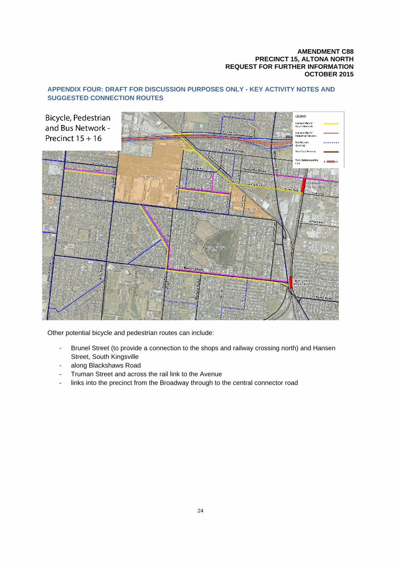
Public transport, active transport and connectivity Moving future residents to and from the precinct and facilitating a mode shift will require the provision of public transport and facilitation of active transport modes. A mode share target must be included in the PSA. An interconnected network of cycling and pedestrian links to key destinations such as those listed below and strong east west connections in the precinct with Kyle Road and New Street are required.
These key nodes include: - Altona Gate shopping centre west at Millers Road, Dousa Street, Beuron Street, Altona - the Circle towards the south - Bradmill site at Francis Street to the north - Federation trail along the Westgate Freeway to the north - Newport train station and activity centre (1.8km from the precinct as the crow flies) - Spotswood train station and Hudson Road Spotswood (1.6km from the precinct as the crow flies)
The preliminary suggested routes are at appendix four and should be considered in addition to the comments made by Bicycle Victoria in relation to the Brunel Street bicycle link. It is emphasised that these routes are preliminary suggestions. They are yet to be costed and endorsed by Council and relevant stakeholders such as VicRoads, Bicycle Victoria and PTV. They provide a starting point for discussion to consider connections from the precinct to its surrounds.
The precinct cannot be viewed as an island site and the Development Contributions Plan (DCP) must address contributions towards these connections as they are imperative to allowing people to enter and leave the precinct. Council is making a commitment to improving active transport and improving connectivity in and around the precinct.
AMENDMENT C88 PRECINCT 15, ALTONA NORTH
REQUEST FOR FURTHER INFORMATION OCTOBER 2015
10
There are bus stops along the precinct boundaries at Blackshaws Road, Altona North. However a bus service should be re routed through the precinct to allow the precinct to connect to the train stations to allow access to the central business district. Preference is to Newport train station as this has a greater number of services. The key connector streets must be able to cater for bus access through the precinct. Bus stops should be within 400 metre walking distance of all dwellings in the precinct.
Road layout and width To provide an integrated transport response, the following must be provided:
- 1.8m wide footpaths on both sides of the roads and streets throughout the precinct - two metre wide designated off road bicycle paths must be provided on both sides of the
connector streets in the precinct - the widths of roads must be increased to the widths outlined in appendix five
CONTAMINATION AND LANDFILL BEST PRACTICE ENVIRONMENT MANAGEMENT (LANDFILL BPEM) Lack of information Contamination has implications on matters such as the location of open space, uses and densities, timing and staging of development (i.e. how long will it take to remediate parcels) and maintenance requirements. There is a lack of information provided in relation to contamination and an informed decision on the PSA is not possible. Council will not endorse an outcome on the precinct without ensuring that contamination can be managed to allow this outcome. Greater detail is required as to what soil and water contaminants are present in the precinct. Details of any remediation works, landfill BPEM issues, quarantine areas, long-term remediation strategies, potential conditions on future statements of environmental audit and any site assessments or audits issued for land in the precinct are required. For further details of what is required, refer to appendix six.
Ongoing monitoring and management requirements Information regarding the ongoing management of any statement conditions or monitoring requirements is needed. If land is capped, details of who is responsible for ensuring caps are maintained and managed in the longer term are critical. Key questions to answer include:
- will the body corporate manage this in high density developments? - how will lower and medium density developments be managed? - how will pools and basements be managed in the future once sites are developed and dwellings
occupied? - if there are any ground water monitoring requirements, details of who is responsible for
compliance with them are required?
Open space areas A PSA will not be adopted unless all the proposed open space areas are remediated and accompanied by statements or certificates of environmental audit. A PSA will not supported unless a report signed off by an auditor is provided that states the site can be remediated in future with no onerous conditions for Council to manage.
Land that has significant ongoing management requirements or any ongoing risk associated will not be accepted.
An example is public park two which is partially located on land at 270 to 274 Blackshaws Road, the Form 700 site. There is currently no information available for this site and it is not one represented by the precinct control group. In the instance that this land owner does not join the precinct control group or does
AMENDMENT C88 PRECINCT 15, ALTONA NORTH
REQUEST FOR FURTHER INFORMATION OCTOBER 2015
11
not want to be involved, Council will not accept PP2 in such a location without a statement or certificate of environmental audit and acceptable conditions (if any) as the risks associated with it are unknown.
Council is not in a position to provide details of exactly what depth of fill etc. will be acceptable for the various open space areas with the limited information presented before it. This will be dependent on the response provided to this contamination section including appendix six and the future use of the open space areas.
Geotechnical reports The precinct housed two former quarries. Geotechnical reports are required to determine whether or not the ground is stable to allow future development. ACOUSTIC AND VIBRATION REQUIREMENTS The precinct experiences noise and vibration from the freight rail line, BTS, Westgate freeway/ surrounding roads and internal industrial uses. Detailed comments on noise and vibration matters are included at appendix seven. Upon request, a meeting will be organised by Council, the applicant and the acoustic and vibration consultants to discuss this matter. Purpose of the noise and vibration assessment The primary purpose of the Marshall Day report ‘is to establish the viability of the proposed uses at the site, rather than specific form and design detail for the proposed uses’2
The purpose should also consider the impact that noise and vibration and associated mitigation requirements will have on the PSA and future development.
More detail and information required The Marshall Day report uses measurements from 2010. Given the dated measurements, together with anomalies discussed in appendix seven, and the ‘preliminary’ or ‘snapshot’ nature of the measurements; new measurements are required to support the report and PSA. It is noted that the Transurban proposal for the Westgate distributor has also altered. This must be factored into any future noise considerations for the precinct. All noise and vibration sources that will affect the PSA and future development should be assessed against their relevant criteria. Any mitigation requirements should be sufficiently developed to understand the impact they will have on the overall PSA and future development. For example, if a noise wall is required along the northern boundary, what will it mean for the amenity and urban design outcomes of the precinct? Will the acoustic mitigation measures result in poor amenity outcomes? Mitigation requirements or options should be presented along with details on how they will be implemented, when they will be implemented and details of any further assessment that will be required, including at what stage this assessment is required.
The following information that can impact on the overall PSA and DP outcomes has been left to the planning permit stage:
- noise walls - buffer zones - restrictions on buildings in certain areas - required acoustic attenuation measures for building construction in certain areas
2 Marshall Day, 2015, Precinct 15: Environment Assessment RP 001 R01 2015051ML, page 5
AMENDMENT C88 PRECINCT 15, ALTONA NORTH
REQUEST FOR FURTHER INFORMATION OCTOBER 2015
12
This information is required as it will have an impact on the possible use and development outcomes on the precinct.
There currently are no triggers for further work required at later stages or commissioning details. These are required along with details of what type of and when mitigation requirements will be implemented. It is anticipated that:
- precinct wide mitigation requirements are to implemented as early as possible and may happen before subdivision or planning permits for specific sites (e.g. site noise walls, buffer zone specification, mitigation to noise sources)
- site specific mitigation requirements that are based on zoning should be implemented during construction/before occupation and considered upon any site application (i.e. if located in a specific zone nearby railway, specific foundations may be required and should be specified in application)
- site specific mitigation requirements that are part of the design form should be implemented during construction/before occupation and considered before building approval (e.g. local noise wall, 200mm depth windows, building layout)
- commissioning given that having requirements for design targets for road traffic and railway noise levels to be verified after construction is imperative
COMMUNITY NEEDS AND SOCIAL INFRASTRUCTURE Housing needs The housing provided will influence the population demographics in the precinct which will impact what services and infrastructure the new community will need. Therefore, a housing diversity report which includes the following is required:
- detailed socio-demographic analysis to provide an in-depth profile of existing population characteristics including family structure, future population growth, migration and income analysis. This is in line with Council’s SIA guidelines which require an analysis of a similar development in a comparable location using the census collection district data. It is acknowledged that the discussion at the external workshops highlighted that there are no other comparable sites. Given the size and scale of the precinct it may be more appropriate to compare it to another suburb that went through redevelopment
- residential market analysis of existing dwelling stock within the catchment, a current supply and demand assessment, historical migration and mobility with an indicative future population analysis and dwelling density assessment
- discussion of housing diversity and a variety of means through which diverse housing outcomes may be achieved through re-development of the precinct
Needs of the new community The findings of the SIA are critical to informing the use of the open space areas, use of the community facility and assist Council with service planning. Detailed comments on the submitted SIA are at appendix eight. Affordable housing Council is reviewing the Hobsons Bay Affordable Housing Policy Statement (Housing Policy Statement) which will inform the PSA. However, ten per cent affordable housing as per the current statement is required. Affordable housing discussions in the SIA must be expanded beyond price point. Council will not support this requirement being considered at a planning panel at first instance. The PSA must include an affordable housing component that is in accordance with Council requirements.

AMENDMENT C88 PRECINCT 15, ALTONA NORTH
REQUEST FOR FURTHER INFORMATION OCTOBER 2015
13
Community facility The proposed community facility must be a flexible space that can be used for a range of purposes however, Council does not have a pre-determined view of what this facility should be used for. Rather the use should be driven by what is proposed, the population expected and the demographic forecasts associated with the proposal. The SIA identifies that the uses of the open space area (and it is assumed, the community facility as well) in particular should be determined as details of the proposed dwelling mix and likely demographic composition of the development are settled. Therefore determining the likely demographics of the precinct is critical. This will also go towards informing the DCP. Location and size of the community facility The size and shape of the community facility area require further justification. Given the anticipated population increases in the precinct, a larger community facility may be more appropriate. Details of how the PSA justifies the 51.5 per cent apportionment cost of the community facility to the precinct are required. The community facility should be positioned in a way that does not dominate the open space reserve frontage or restrict passive surveillance from the collector road interface. The facility should be designed to be able to activate all sides to address its prime corner position and the quarry park. An analysis of the community and social benefits and economic implications associated with co-locating the NAC, community facility and open space is required. Open space The PSA proposes 7.4 per cent open space (4.96 hectares)3 comprising of one neighbourhood space (2.94 hectares), four local spaces (0.25ha to 0.38ha) and a north south linear reserve (0.74ha). The PSA proposes a high density outcome that is approximately 5.5 times the average current population density in the residential areas of Hobsons Bay, likely with dwellings containing significantly less private open space areas increase demand for public open space. The open space contribution rate proposed has been calculated considering population ratios. Preliminary calculations suggest that the average provision of unencumbered and unrestricted open space across the municipality, including regional open space and worker population, is approximately 3.4 hectares per 1,000 people. Consequently, a greater provision of open space is required as part of the PSA. In addition, preliminary work has suggested that local parks should be a minimum of one hectare in size. Further discussions with Council will go towards informing the level of provision and distribution of open spaces. The use of the open space areas should be informed by the demographics of the precinct which are in turn influenced by the dwelling type proposed. The outcomes of the housing diversity report will inform the SIA which in turn will influence the provision of passive and active open space provision in the precinct. Demand on supporting infrastructure The current passive open space provision with no formal sporting facilities is not acceptable as a mix of both formal sporting and passive uses are required. Taking into consideration that the precinct is within one kilometre of Newport Lakes, Edwards Reserve (soccer), AW Langshaws Reserve (cricket) and Paisley and McIvor Reserves (regional sporting reserves) the new community will be well served for
3 Taken from the development plan.
AMENDMENT C88 PRECINCT 15, ALTONA NORTH
REQUEST FOR FURTHER INFORMATION OCTOBER 2015
14
regional open space and formal sporting opportunities. However all these clubs are at, or close to capacity and will have limited opportunity to accept more members.
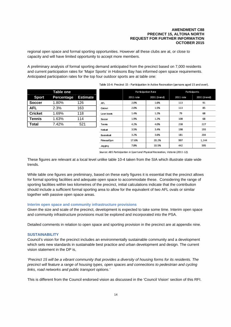
A preliminary analysis of formal sporting demand anticipated from the precinct based on 7,000 residents and current participation rates for ‘Major Sports’ in Hobsons Bay has informed open space requirements. Anticipated participation rates for the top four outdoor sports are at table one:
Table one Sport Percentage Estimate
Soccer 1.80% 126 AFL 2.3% 163 Cricket 1.69% 118 Tennis 1.63% 114 Total 7.42% 521
These figures are relevant at a local level unlike table 10-4 taken from the SIA which illustrate state wide trends. While table one figures are preliminary, based on these early figures it is essential that the precinct allows for formal sporting facilities and adequate open space to accommodate these. Considering the range of sporting facilities within two kilometres of the precinct, initial calculations indicate that the contribution should include a sufficient formal sporting area to allow for the equivalent of two AFL ovals or similar together with passive open space areas. Interim open space and community infrastructure provisions Given the size and scale of the precinct, development is expected to take some time. Interim open space and community infrastructure provisions must be explored and incorporated into the PSA. Detailed comments in relation to open space and sporting provision in the precinct are at appendix nine. SUSTAINABILITY Council’s vision for the precinct includes an environmentally sustainable community and a development which sets new standards in sustainable best practice and urban development and design. The current vision statement in the DP is, ‘Precinct 15 will be a vibrant community that provides a diversity of housing forms for its residents. The precinct will feature a range of housing types, open spaces and connections to pedestrian and cycling links, road networks and public transport options.’ This is different from the Council endorsed vision as discussed in the ‘Council Vision’ section of this RFI.
AMENDMENT C88 PRECINCT 15, ALTONA NORTH
REQUEST FOR FURTHER INFORMATION OCTOBER 2015
15
Sustainability and best practice must be included in the vision as the precinct presents a significant opportunity to implement best practice sustainability outcomes given its size and scale. Clear commitment to best practice environmentally sustainable design (ESD) in the precinct is required. The PSA and DP do not include sufficient details of what will actually be implemented as part of the redevelopment of the precinct. Terminology such as ‘consideration of,’ ‘encourage,’ ‘recommended,’ and ‘subject to further investigation’ do not provide sufficient comfort that these initiatives will actually be implemented. While section 4.4.7 of the DP provides a good starting point, it lacks the level of certainty expected in such a plan. Initiatives that must be incorporated into the redevelopment of the precinct include:
- material reuse, recycling etc is required as part of the redevelopment of this precinct. A waste management and recycling strategy should inform the DP with its key recommendations included in the DP itself
- alternatively, the DP can set out recycling/ sustainability principles - the introduction of a third pipe into the precinct is expected. City West Water is currently exploring
this option - built form and layout principle must incorporate ESD e.g. landscaping and green roofs can be
used to reduce the urban heat island effect - the actual preparation of ESD construction guidelines for each of the precincts rather than
recommendation of their development as section 4.7 of the DP does - exploration of electricity self-generation and electricity car charge schemes, new and renewable
energies such as smart grids and battery storage - use of the Built Environment Sustainability Scorecard (BESS) rather than Sustainable Tools for
Environmental Performance Strategy (STEPS) - design measures that reduce the urban heat island effect - potential for community gardens (subject to contamination) in open space areas
The PSA must consider Council’s existing sustainability policies which include:
- Climate change policy 2013 - Climate change adaptation plan 2013-2018 - Community Greenhouse Strategy 2013-2030 - Living Hobsons Bay: Integrated Water Management Plan 2014-2019 - Waste and Litter Management Plan 2012-2017
GreenStar Communities The GreenStar multi unit tool can be used as a target however, the Green Building Council of Australia (GSBCA) recently released their GreenStar Communities tool and should be used to guide the redevelopment of the precinct. The fact that the precinct has multiple land owners does not preclude this tool from being used. A meeting between the GSBCA, Council and yourself can be organised to discuss this. INFRASTRUCTURE REQUIREMENTS Infrastructure requirements and drainage including Water Sensitive Urban Design As discussed at our external workshop, undergrounding the power lines in and along the precinct interfaces should be further explored. All power lines must be undergrounded as part of this development. Detailed comments regarding drainage and water sensitive urban design are at appendix ten to this document.
AMENDMENT C88 PRECINCT 15, ALTONA NORTH
REQUEST FOR FURTHER INFORMATION OCTOBER 2015
16
DEVELOPMENT CONTRIBUTIONS The precinct is not an island site or a greenfield development. Apportionment towards infrastructure surrounding the precinct must be considered in the DCP. Detailed comments on the DCP are at appendix 11 to this document. S173 OF THE PLANNING AND ENVIRONMENT ACT 1987 Acknowledging discussions and correspondence provided regarding this matter, it is too premature in the PSA process for Council to rule out the use of agreements pursuant to section 173 of the Planning and Environment Act 1987. STAGING AND SEQUENCING The staging and sequencing of development in the precinct must be provided. While it is acknowledged that this may be a difficult task given the nature of land ownership in the precinct, the question of what will occur where and when must be addressed to a greater degree than figure 32 in the DP. This will inform matters such as infrastructure provision, management of interfaces with industry and other uses including the freight rail line and triggers for the provision of open space and the community facility. OTHER INFORMATION REQUIRED The following information is required as part of the PSA
- title certificates and any particulars recorded on titles for the entire precinct - a three dimensional model and walk through of the potential development outcomes on the
precinct - an implementation document that highlights how and when recommendations of various reports
will be implemented e.g. whether through the planning tools proposed, at the DP stage, planning permit stage or by some other means
- the street names must be in line with the Office of Geographic Names guidelines for the naming of roads, streets, reserves etc.
AMENDMENT C88 PRECINCT 15, ALTONA NORTH
REQUEST FOR FURTHER INFORMATION OCTOBER 2015
17
APPENDIX ONE: COMMENTS ON PLANNING AND URBAN DESIGN MATTERS Information required The following information is required:
- amendments to the following clauses are required to provide strategic recognition and basis for the precincts anticipated use and development
o Clause 21.02: Hobsons Bay key issues and strategic vision o Clause 21.09: Transport and mobility o Clause 22.02: Industry
Aspects of the proposal that require further clarification The following aspects of the amendment package require further clarification:
- what are the ‘innovative’ built form typologies referred to? - how will the public realm ‘celebrate’ the industrial history of Altona North? - how have the end of street vistas been ‘carefully crafted’? - how will the connection north to McIvors Reserve be ‘enhanced’? - what are the ‘appropriate interfaces’ provided between character areas? - how will dwelling density be distributed over the precinct? - how are the development outcomes envisaged by the DP considered ‘diverse’? - how does the medium density housing ‘appropriately consider’ existing residential areas? - what is the basis for the precinct areas in figure 33 of the DP?
Although typical cross sections are used in the DP, the full potential height should be shown to accurately represent the potential heights possible on the precinct. State Planning Policy and Local Planning Policy Justification The assessment against the State Planning Policy and Local Planning Policy Frameworks provided in the Strategic Justification document is lacking. An explanation of why and how the amendment meets or is consistent with relevant policy should be provided rather than a repetition of the objectives.
AMENDMENT C88 PRECINCT 15, ALTONA NORTH
REQUEST FOR FURTHER INFORMATION OCTOBER 2015
18
APPENDIX TWO: COMMENTS ON THE DEEP END ECONOMIC ASSESSMENT The below comments are specific to the Deep End economic assessment but will have implications on the overall PSA. Indicative need
- the Melbourne @ 5 Million hierarchy should not be used. It is inappropriate to use a regional hierarchy for the purpose of analysing supply and demand on a local area in isolation. The retail hierarchy of regional, sub regional and neighborhood centres should be used
- table one appears to show an oversupply of major activity centre floor space. However a major activity centre always serves a much wider catchment, and when in close proximity, essentially removes the need for a NAC. Therefore the major contention that there is an undersupply of NAC floorspace may be misleading
- the ratios used in table one can only make sense if the development is self contained. This catchment is serviced by a number of centres and is not isolated. Therefore, population to floor space ratios are a poor measure of the supply and demand equation in this context. The appropriate method is to clearly define where catchment boundaries are and how much local spending is actually captured
- figure ten shows that there is a general undersupply of supermarket floor space in the municipality. It also highlights that:
o future residents of the precinct will be within five minutes access of at least 6,000m2 (not including the McLister Street Neighborhood Activity Centre) of supermarket floor space which is the equivalent of almost two full line supermarkets. Justification is required as to why this is considered inadequate
o that there are other parts of the municipality that are in much greater need of supermarket floorspace than the precinct
o there is no geographical gap in the provision of supermarkets in the area and around the precinct
Trade area analysis While generally, the defined trade areas identified in figure 11 are acceptable, details are required as to how the precinct will actually play a local role if it is drawing significant trade west of Millers Road and north of West Gate Freeway into Brooklyn.
Population forecasts Generally the population numbers presented in table three are acceptable. However given that development of the precinct may occur over a 15 to 20 year period, population projections beyond 2012 are required. Alternatively, details of why projections past 2012 were not provided are required.
Retail spending There is usually a greater level of delineation between the various commodity types presented in tables four and five. E.g. providing details of supermarket food, non supermarket food, fashion, bulky goods etc. Providing this level of specificity will be beneficial.
Competitive analysis While not explicitly discussed in the Deepend document, table seven shows that supermarket anchors in neighbourhood centers are no larger than 2,500 m2 while the majority of these NACs are no larger than 3,600 m2. This shows that a 5,500 m2 NAC that is anchored by a 4,200 m2 supermarket is not be in
AMENDMENT C88 PRECINCT 15, ALTONA NORTH
REQUEST FOR FURTHER INFORMATION OCTOBER 2015
19
keeping with what is expected of a NAC in this area. Given the existing competition, the proposed NAC will be highly competitive which suggests trade diversions that would be greater than what could usually be expected of a 5,500 m2 retail development.
Market assessment
- table eight underestimates the retail turnover density and requires revision. The $7,400 per m2 is quite low and cannot be accepted, with implications for underestimating captured trade (and therefore trade diversions from other centres) needing to be borne in mind
- a similar pattern of underestimation is also noted for market share as shown in table nine. The numbers presented cannot be justified and in combination with the low retail turnover density, they appear to lead to a significant underestimation of trade diversions
Economic (trade diversion) impact
- impacts highlighted in table ten appear to be very low for the Circle which is in close proximity to the proposed NAC and will compete directly for supermarket expenditure. It is likely that the Circle will be significantly impacted by the proposed NAC as it has no alternative but to attract most of its customers from a trade area that is almost identical to the Circle’s
- the Circle is likely to be at a further disadvantage due to its location if the proposed NAC is to remain along Blackshaws Road – thereby providing it prominence and access
- the impacts for centres such as Williamstown, Yarraville Square and the Rifle Range are high and require review. By over emphasising the impact on these centres, the projected economic impact is spread over a broader region and wider number of centres, thereby diluting the figures for likely impact on the centres which are most likely be under threat (such as Borrack Square and the Circle). The Deepend report is essentially indicating that of the $38.3 million in turnover expected for the proposed NAC, almost 25 per cent will be drawn from three centres that have little economic relationship with the precinct and its surrounding local area. If this is actually the case, then the proposed development would not be playing a local role
Net Community Benefit considerations
- while direct employment numbers are acceptable, they do not necessarily constitute net community benefit because these jobs are simply a reflection of expenditure in the local area. The trade diversion analysis suggests that most of these jobs are likely to have been redistributed from other activity centres in the municipality and elsewhere in the metropolitan area. Therefore these employment numbers cannot be interpreted as net benefits to the Victorian community
- the use of multipliers to provide an estimate of indirect employment is misleading since these jobs could be anywhere in the Australian economy (or if goods are imported, then anywhere in the global economy). Irrespective, these multipliers are linked to retail spending, which will occur elsewhere if it doesn’t occur on the precinct. The Victorian Treasury recommends against the use of multipliers in net community benefit analyses
- direct employment yields tend to be the limit for the net community benefit test and should be used in this instance
AMENDMENT C88 PRECINCT 15, ALTONA NORTH
REQUEST FOR FURTHER INFORMATION OCTOBER 2015
20
APPENDIX THREE: COMMENTS IN RELATION TO THE GTA TRANSPORT IMPACT ASSESSMENT At the outset, a meeting to discuss the findings of the cumulative impact assessment, its implications on the precinct including impacts on assumptions of the TIA can be organised once the assessment is finalised. The key assumptions and parameters of the TIA must be set in consultation with Council, VicRoads and PTV and must be informed by the cumulative impact assessment.
The TIA requires significant review as per the commentary below. - the traffic report should consider all surrounding key development sites including the following:
o the Former Caltex Site at 38 – 48 Blackshaws Road and 24 Sutton Street, South Kingsville which has a proposal for up to 600 dwellings
o the remainder of precinct 16 which may cater for up to 670 dwellings o precinct 20, the Former Port Phillip Woollen Mills, expected to cater for approximately 898
dwellings o the McLister Street NAC at 31 – 69 McLister Street which has a planning permit approved
‘use and development of the land for the purpose of a NAC including two supermarkets, mini-major tenancy (shop), specialty shops, medical centre and 240 dwellings plus a reduction in the standard car parking requirement’
o the Bradmill redevelopment which has an approved DP that caters for up to 1,500 dwellings, a NAC and library4
- the data used in the traffic counts is from 2012 and is dated and requires review
o there has been a significant increase in population since then, especially in Wyndham (which would impact traffic being able to get on and off the freeway from Millers Road), so the traffic data does not reflect the current and the projected levels of traffic expected to use the municipality as a thoroughfare. There has also been significant traffic growth along Melbourne Road and Millers Road due to excessive traffic arriving from Queen Street and Kororoit Creek Road
o these counts, along with new signal phasing and queuing surveys need updating to reflect the current conditions. Recent traffic volumes should be used in the TIA and associated SIDRA models
- the accident statistics require updating - the following intersections should also be included in the traffic report:
o Millers Road/ Altona Gate access/ Cyclamen Avenue o Blackshaws Road/ The Broadway o Melbourne Road/ the Avenue o Kernot Street/ The Avenue o Brunel Street rail crossing o Clemantis Avenue/ Millers Road o Sutton Street/ Blackshaws Road o The Melbourne Road/ Westgate freeway interchange and the Millers Road/ Westgate
freeway interchange
4 While this may not have an impact on the majority of intersections considered in the TIA, the Melbourne Road/ The Avenue intersection is likely to experience significant additional traffic from the Bradmill site as this is the route that traffic from the site is most to use to access the Westgate Freeway.

AMENDMENT C88 PRECINCT 15, ALTONA NORTH
REQUEST FOR FURTHER INFORMATION OCTOBER 2015
21
- there is potential that the amount of traffic turning onto the Westgate freeway at these locations can represent more than ten per cent of the existing volumes. If that is the case, these locations should also be included in the TIA
- the following local roads should also be considered in the surrounding local road network discussion of the TIA:
o Kyle Road o New Street o Cyclamon Avenue
- details are required as to why a proportion of zero per cent heavy vehicles has been adopted on all
intersection approaches for all intersections. The inclusion of heavy vehicles in the models is expected to make a difference particularly at the unsignalised intersections where there is a high volume of existing traffic e.g. at the Melbourne Road/ Ross Street
- currently, the GTA TIA recommends increasing the lengths of the ‘no stopping’ parking restrictions and the introduction of dedicated right turn lanes at Kyle Road, New Street, Hansen Street and the Broadway unsignalised intersections along Blackshaws Road. Consequently, a comprehensive review of on street car parking demands along the precinct’s frontage with Blackshaws Road (on both sides of the road) is required to ensure that parking demands can be adequately accommodated and parking impacts are minimal. A concept layout plan should be prepared for the length of Blackshaws Road along the precinct frontage to help determine the impact of the changes proposed
- provide concept plans showing extensions to such road infrastructure as turn lanes, footpaths and bike lanes that are required as a result of the development of the precinct to give an indication of what the impacts on the on street car parking and road configuration
- as discussed below, a number of key assumptions in the TIA for surrounding intersections and directional traffic require review. These assumptions should be discussed and agreed to by Council and VicRoads prior to further analysis being done by GTA
- a number of the assumptions used in the SIDRA model appear to be invalid. A review of the assumptions suggests that ‘highly favourable’ conditions for the precinct intersections are invalid given that there is no signal coordination along these corridors
- Melbourne Road / The Avenue (PM Peak) o north approach signal coordination adjusted to ‘Highly Favourable’ –
should be ‘Favourable’
- Melbourne Road / Hudsons Road (AM Peak) o south approach signal coordination adjusted to ‘Highly Favourable’ –
should be ‘Favourable’
- Melbourne Road / Hudsons Road (PM Peak) o north approach signal coordination adjusted to ‘Highly Favourable’ –
should be ‘Favourable’ o north approach and South approach right turn gap acceptance
parameters are not appropriate as there are no filter turns allowed during this period
- Millers Road / Blackshaws Road (AM Peak)
o north approach signal coordination adjusted to ‘Highly Favourable’ – should be ‘Average’
AMENDMENT C88 PRECINCT 15, ALTONA NORTH
REQUEST FOR FURTHER INFORMATION OCTOBER 2015
22
o east approach signal coordination adjusted to ‘Highly Favourable’ – should be ‘Average’. The right turn movement filters after fully controlled right turn
- Millers Road / Blackshaws Road (PM Peak)
o east approach signal coordination adjusted to ‘Highly Favourable’ – should be ‘Average’
- Millers Road / Marigold Avenue / Duosa Road (AM Peak)
o south approach signal coordination adjusted to ‘Highly Favourable’ – should be ‘Favourable’
- Millers Road / Marigold Avenue / Duosa Road (PM Peak)
o south approach signal coordination adjusted to ‘Highly Favourable’ – should be ‘Average’
- given the above, the SIDRA models need updating and the operation of the precinct
intersections re-assessed. Prior to doing this, the assumptions should be confirmed with Council and VicRoads
- based on GTA’s traffic assessment, the following should be noted in regards to traffic performance of the existing intersections with respect to the precinct:
- Melbourne Road / The Avenue intersection o the west approach of The Avenue currently operates with acceptable
levels of service with moderate traffic queuing during the peak periods
o the north and south approaches of Melbourne Road operate with acceptable levels of service with moderate traffic queuing close to 100m during the peak periods
- Melbourne Road / Hudsons Road intersection o the north and south approaches of Melbourne Road operate with
traffic queuing in excess of 100m during the peak periods
- Melbourne Road/Ross Street intersection o the north and south approach operate with minimal queuing and
excellent levels of service as this is a priority intersection o consistent with previous advice in reference to the Former Caltex
Site, South Kingsville, traffic queuing is a consistent issue in Ross Street during peak periods. Past advice has also highlighted that SIDRA modelling for this intersection was not calibrated to the existing operating conditions
- Blackshaws Road / Schutt Street intersection
o there have been two serious injury crashes at this intersection o there have been mitigating works proposed as part of development
associated with the Former Caltex Site, South Kingsville
- Blackshaws Road / Kyle Road / Mills Street intersection
AMENDMENT C88 PRECINCT 15, ALTONA NORTH
REQUEST FOR FURTHER INFORMATION OCTOBER 2015
23
o the east approach of Blackshaws Road at this intersection operates with excellent levels of service with moderate traffic queuing approaching close to 100m
- Millers Road / Blackshaws Road intersection o there is no signal coordination along this corridor and hence the
model needs to be updated as suggested o based on current traffic analysis, it is clear that north and south
approaches of Melbourne Road operate with excessive traffic queuing with east and west approaches of Blackshaws Road approaching moderate traffic queuing close to 100m during the peak periods
- Millers Road / Marigold Avenue / Duosa Road intersection - the north and south approaches of Millers Road operate with
excessive traffic queuing during the peak periods
- raw SIDRA data for all intersections must be provided with the revised TIA to ensure that conclusions can be verified
- the TIA for the Caltex Site concluded that the surrounding road network will experience difficulties once precincts 15 (the precinct), 16, 17 and a number of other key development sites are completely developed. The tipping point appears to be the redevelopment of this precinct. Therefore it is unclear as to how the GTA TIA submitted with the amendment proposal came to its conclusions given the same firm prepared both documents
- when comparing both the Caltex TIA and precinct 15 TIA, there are inconsistencies in the two documents:
- the existing traffic volumes are the same however the traffic volumes for Blackshaws Road/ Millers Road and Blackshaws Road/ Kyle Road/ Mills Street differ. Consistency between the two documents is require or an explanation as to why they differ
- the existing SIDRA intersection models that are presented in the TIA for the Former Caltex Site and this precinct provide different outputs, even for locations where the input traffic volumes appear to be the same. A consistent set of SIDRA outputs should be provided for both sites or an explanation as to why they differ
- key assumptions and parametres such as traffic generation rates, traffic splits and distribution
and discount rates are to be determined in consultation with VicRoads, Council and PTV - addressing the above commentary will alter the findings of the TIA in relation to post development
traffic estimations, post development traffic performance and the proposed traffic mitigation works will be required. Detailed commentary in relation to these portions of the TIA has not been provided for that reason. Any errors in relation to the traffic estimation and post development conditions should be corrected
AMENDMENT C88 PRECINCT 15, ALTONA NORTH
REQUEST FOR FURTHER INFORMATION OCTOBER 2015
24
APPENDIX FOUR: DRAFT FOR DISCUSSION PURPOSES ONLY - KEY ACTIVITY NOTES AND SUGGESTED CONNECTION ROUTES
Other potential bicycle and pedestrian routes can include:
- Brunel Street (to provide a connection to the shops and railway crossing north) and Hansen Street, South Kingsville
- along Blackshaws Road - Truman Street and across the rail link to the Avenue - links into the precinct from the Broadway through to the central connector road
AMENDMENT C88 PRECINCT 15, ALTONA NORTH
REQUEST FOR FURTHER INFORMATION OCTOBER 2015
25
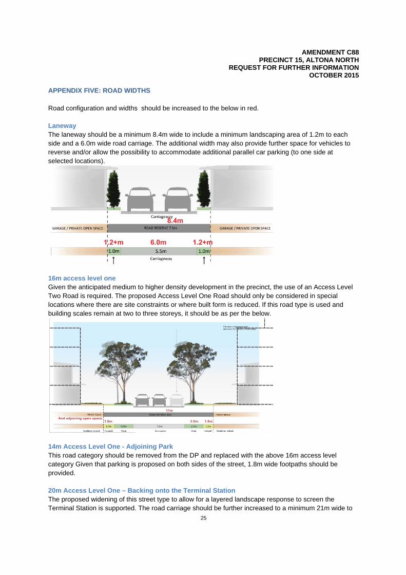
APPENDIX FIVE: ROAD WIDTHS Road configuration and widths should be increased to the below in red. Laneway The laneway should be a minimum 8.4m wide to include a minimum landscaping area of 1.2m to each side and a 6.0m wide road carriage. The additional width may also provide further space for vehicles to reverse and/or allow the possibility to accommodate additional parallel car parking (to one side at selected locations).
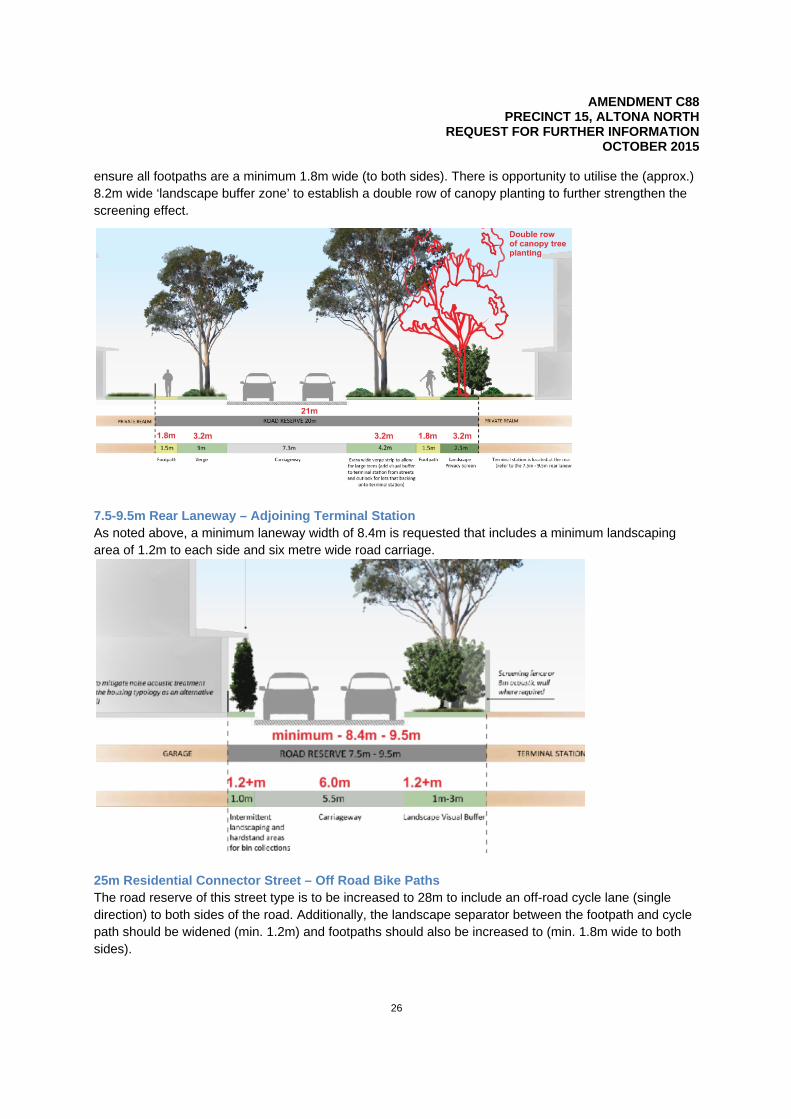
16m access level one Given the anticipated medium to higher density development in the precinct, the use of an Access Level Two Road is required. The proposed Access Level One Road should only be considered in special locations where there are site constraints or where built form is reduced. If this road type is used and building scales remain at two to three storeys, it should be as per the below.
14m Access Level One - Adjoining Park This road category should be removed from the DP and replaced with the above 16m access level category Given that parking is proposed on both sides of the street, 1.8m wide footpaths should be provided. 20m Access Level One – Backing onto the Terminal Station The proposed widening of this street type to allow for a layered landscape response to screen the Terminal Station is supported. The road carriage should be further increased to a minimum 21m wide to
AMENDMENT C88 PRECINCT 15, ALTONA NORTH
REQUEST FOR FURTHER INFORMATION OCTOBER 2015
26
ensure all footpaths are a minimum 1.8m wide (to both sides). There is opportunity to utilise the (approx.) 8.2m wide ‘landscape buffer zone’ to establish a double row of canopy planting to further strengthen the screening effect.
7.5-9.5m Rear Laneway – Adjoining Terminal Station As noted above, a minimum laneway width of 8.4m is requested that includes a minimum landscaping area of 1.2m to each side and six metre wide road carriage.
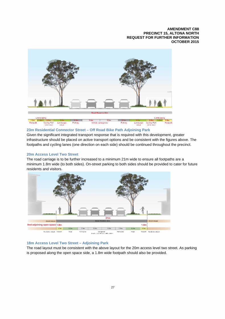
25m Residential Connector Street – Off Road Bike Paths The road reserve of this street type is to be increased to 28m to include an off-road cycle lane (single direction) to both sides of the road. Additionally, the landscape separator between the footpath and cycle path should be widened (min. 1.2m) and footpaths should also be increased to (min. 1.8m wide to both sides).
AMENDMENT C88 PRECINCT 15, ALTONA NORTH
REQUEST FOR FURTHER INFORMATION OCTOBER 2015
27
23m Residential Connector Street – Off Road Bike Path Adjoining Park Given the significant integrated transport response that is required with this development, greater infrastructure should be placed on active transport options and be consistent with the figures above. The footpaths and cycling lanes (one direction on each side) should be continued throughout the precinct. 20m Access Level Two Street The road carriage is to be further increased to a minimum 21m wide to ensure all footpaths are a minimum 1.8m wide (to both sides). On-street parking to both sides should be provided to cater for future residents and visitors.
18m Access Level Two Street – Adjoining Park The road layout must be consistent with the above layout for the 20m access level two street. As parking is proposed along the open space side, a 1.8m wide footpath should also be provided.
AMENDMENT C88 PRECINCT 15, ALTONA NORTH
REQUEST FOR FURTHER INFORMATION OCTOBER 2015
28
APPENDIX SIX: CONTAMINATION AND REMEDIATION INFORMATION REQUIRED The following information is required: For properties currently subject to a Section 53X environmental audit - letters from the appointed environmental auditors summarising:
- investigation works undertaken to date - nature and extent of contamination identified to date - nature and extent of remediation that is likely to be required to make the site suitable for the
proposed sensitive use - status of remediation works - likely timing for completion of remediation works and the audit - anticipated statement conditions that will apply to the site
For properties where Detailed (Phase 2) investigations are underway, but no auditor has been engaged - further information, prepared by a suitably qualified environmental professional, detailing:
- investigation works undertaken to date - nature and extent of contamination identified to date - nature and extent of remediation that is likely to be required to make the site suitable for the
proposed sensitive use - anticipated timing for engagement of an environmental auditor and completion of remediation
works
For properties where no or limited investigations have been completed - a Preliminary Environmental Site Assessment detailing:
- nature of the previous land uses or activities - nature and extent of contamination that may be present - based on the known land uses and associated likely contaminants, an overview of the potential
impacts that contamination could have on land use, densities, built form and the general content of the structure plan
- an opinion as to whether contamination could be present which would prevent the proposed use of the land
- anticipated timing for conduct of further assessment and/or remediation works, and completion of an environmental audit
- how ongoing operations and/or residual contamination at these sites will impact on redevelopment areas, if these sites continue to be used for industrial purposes or remain vacant once redevelopment to sensitive land use begins in other areas within the precinct
A site remediation strategy is required for the precinct together with an explanation of why some of the elements of the strategy cannot be submitted at this point.
AMENDMENT C88 PRECINCT 15, ALTONA NORTH
REQUEST FOR FURTHER INFORMATION OCTOBER 2015
29
APPENDIX SEVEN: COMMENTS ON THE MARSHALL DAY ACOUSTICS REPORT Noise measurement anomalies The following comments are made in relation to the noise measurements:
- the night time and evening measurements at location may have been affected by insect noise or wind increasing the level above daytime levels
- the average (Leq) measurement at location four is affected by a bus passbys which does not affect the statistical average maximum (L10) measurement
- the measurement next to the substation (location one) is no longer used for road traffic assessment. The current measurement ‘snapshot’ does not provide sufficient information for council to understand the site conditions or properly inform noise limits and mitigation
- confirmation of unusual measurement outcomes are required Updated measurements are required. Trigger or threshold requirements for further consideration of acoustic matters and compliance testing mechanisms The following details are required to inform the PSA and DP:
- identification of all noise sources that require further noise measurements and investigation - triggers for further assessment for the following:
o train vibration § when and how to apply further analysis to address any figure vibration matters
such as the use of timbre frames
o noise from industrial and commercial sources § when and how to apply further discussion and assessment of commercial and
industrial noise during the project phasing are required § details of mechanism for how to apply building treatments is required e.g.
whether a certain slab, frame or window glazing will be required to address the specific noise
o road traffic noise § when acoustic traffic modeling will be required § if and when building treatments will be required or if and when larger scale
mitigation measures will be required (such as a noise wall)
- more detail regarding the preferred or recommended approach for road traffic noise mitigation - indicative train noise treatment to meet internal noise levels - finalised building restrictions that may apply for train vibrations - detailed or specific measurement of noise industrial or commercial noise sources - more detail regarding the indicative industrial noise treatment to meet noise limits
The above detail is required to inform the PSA and DP. Examples that may impact on the DP include:
- whether or not an eight metre barrier is actually proposed given the practicality, amenity impacts and the likelihood to achieve a 25dBA reduction
- whether building treatment is proposed and what buildings will be affected given the required buffer zones for maintenance and practicality of an eight metre, 150mm concrete façade with 200mm air gap windows

AMENDMENT C88 PRECINCT 15, ALTONA NORTH
REQUEST FOR FURTHER INFORMATION OCTOBER 2015
30
- whether building layout planning is proposed and what buildings will be affected given the restriction in gaps between building zones for maintenance and practicality of an eight metre, 150mm concrete façade with 200mm air gap
- whether there are any building restrictions or requirements adjacent to the railway Comments should be sought from VicRoads regarding treatments along the Westgate Freeway Train vibration criteria A Vibration Dose Value criteria approach is provided but no specific criteria or approach to its application is proposed. It is recommended that the ‘low probability of adverse comment’ is clearly identified as the criteria or target. Noise from industrial and commercial sources While the current noise assessment considers future zoning, provides zoning levels for four sites representing difference adjacencies and provides an expected variation in noise limit; these limits are considered to represent worst case noise limits, do not consider a measured noise level and are not final.
Worst case noise limits are useful in some instances; however they limit the ability to apply checking mechanisms, triggers or indicative treatment of noise sources which may impact on the DP. More finalised State Environment Protection Policy (control of noise from industry, commerce and trade) No N-1 (SEPP N1) limits must be determined across the precinct to a greater extent than currently done so in the noise assessment. This is to inform the development of triggers for mitigation requirements and the design of mitigation requirements. The agent of change principle is applied to noise limit discussion for music and commercial noise. There is however, no assessment of project phasing that may create temporary interfaces. This interface treatment is required. Details of indicative noise mitigation measures are provided to understand the overall impact on the DP (e.g. is the acoustic wall along the BTS two metres or eight metres or will it be built form and landscape measures?). Road traffic noise Long term noise monitoring for the Westgate freeway noise should be undertaken and used to inform the assessment and DP. If information is available, this should include the potential Western Distributor. A previous long term measurement from 2010 at 160m from the Westgate freeway was used to provide the LA10, 18hr noise level. The long term measurement was affected by weather for the three days of the data obtained. Worst case LA10, 18hr measurement of 60dBA was used for the criteria. The criteria from this long term measurement (at 160m) has not specifically been used for assessment for residential receiver locations adjacent to the freeway. Long term noise monitoring is required at location five (adjacent to Blackshaws Road). Currently, a short term noise measurement of 72dB is used to estimate the LA 10, 18hr parameter. While the measurements may not impact the overall assessment undertaken, they are required. Locations that will require further noise assessment Indicative locations that need further noise assessment at a later stage are required for all noise sources including details of the expected assessment, requirements and the broad impact it may have on the PSA

AMENDMENT C88 PRECINCT 15, ALTONA NORTH
REQUEST FOR FURTHER INFORMATION OCTOBER 2015
31
and DP. This must be done for train vibration, industrial and commercial noise sources and road traffic noise.
AMENDMENT C88 PRECINCT 15, ALTONA NORTH
REQUEST FOR FURTHER INFORMATION OCTOBER 2015
32
APPENDIX EIGHT: COMMENTS ON THE PUBLIC PLACE SOCIAL IMPACT ASSESSMENT Strategic importance of the precinct to the municipality The precinct is 67 hectares in size, half the size of the Melbourne central business district and will introduce a population greater than some of the municipality’s existing suburbs. Given this, the SIA should include introductory comments regarding the strategic importance of this precinct to the municipality. The SIA should specifically note that the precinct will assist in meeting the Western Sub Region targets for plan Melbourne. Demographics .Id prepare forecast data for the municipality based on a number of assumptions. The latest data prepared in December last year did not have the indicative timeframe of development commencement and completion as this information was not available at the time. Updated forecast population figures for the precinct to cater for 3,000 dwellings under the proposed built form timelines are currently being prepared and should be available in the coming weeks. The SIA must use the new data. Dwelling number and type The SIA states that 3,000 dwellings is the assumed yield but not the upper limit to the precinct’s capacity and that the dwelling mix is subject to change. Given that a DPO is proposed, certainty is required in relation to dwelling numbers and the SIA should acknowledge a 3,000 dwelling maximum yield. The SIA also includes a breakdown of dwelling type which informs the type of residents anticipated to reside in the precinct. Justification for this break down of dwelling type is required and should include market demand. The housing diversity report can include a section that considers market demand. Although this was discussed at the workshops, the SIA must include this detail. Market demand and assumptions Further research/investigation into expected levels of market demand / take up of products should be included, and any assumptions made about the likely demographics of the development should be sourced and/or backed up by research. For example, although there’s a discussion around the demographic groups that may take up the smaller apartments, the source of these assumptions is unknown. The discussion at the external workshops helped clarify this point however the SIA itself needs to address this. Details are required in relation to the methodology used to determine the figures at table 7-1 of the SIA. The citation to ABS data (2012) and Public Place (2014) provides little detail or way of checking the data presented. Actions and discussions associated with how marketing and showcasing of the higher density elements would be considered in due course should be included in the SIA to show how the precinct will be integrated into the existing community. Case study required Further evidence/ case studies regarding other recent examples of how similar development to precinct 15 attracted demographic groups and/ or discussions with real estate agents to inform such opinions would provide a more robust foundation for the assumptions presented. Council’s SIA guidelines require an analysis of a similar development in a comparable location using the census collection district data. This analysis has not been undertaken as required by Council’s SIA guidelines – this is still required. It is acknowledged that the discussion at the external workshops highlighted that there are no other comparable sites. Given the size and scale of the precinct it may be more appropriate to compare it to

AMENDMENT C88 PRECINCT 15, ALTONA NORTH
REQUEST FOR FURTHER INFORMATION OCTOBER 2015
33
another suburb that went through redevelopment. Alternatively, the difficulty in identifying a comparable site/ suburb should be discussed in the SIA. Documents that should be considered by the Social Impact Assessment The following documents require consideration in the SIA:
- An assessment against relevant areas of the State Planning Policy Framework - Council Plan 2013 – 2017 - Open Space Strategy – acknowledging that it is in review - Libraries Strategic Plan 2012 – 2015 - Community Health and Wellbeing Plan 2013 – 2017 - Hobsons Bay Strategic Bicycle Plan 2013 – 2017 - Road Safety Strategy 2011 – 2013 - Advocacy Strategy 2014 – 2018
Impacts of developing the precinct The SIA does not discuss the negative impacts associated with the development of the precinct and therefore does not mention any mitigation strategies. The product proposed for the precinct will differ from the immediate development surrounds and therefore it would be beneficial for the SIA to further investigate and outline:
- the likely market demand for the proposed product - any mitigation measures that are recommended to ensure that a sense of community/ cohesion
and integration of the development into the community is maximised
The SIA should also consider the impacts of any potential liqour sale on the NAC component of the PSA.
Accessibility to facilities within the precinct The precinct is approximately 920m by 850m and facilities that are accessible to one side (e.g. the western edge of the precinct) may not be as accessible at its eastern edge or for those that will reside in the central parts of the precinct. This requires appropriate consideration and recommendation for improvements. Universal access The SIA does not discuss universal design or accessibility of the development for people with a disability or parents with prams or the elderly. How the precinct will deliver on this aspect must be included together with an understanding of how it will be incorporated into the DP. Affordable housing Affordable housing discussions in the SIA require expansion as currently affordable housing is discussed only in terms of pricing points in that a lower price point can meet the current affordable housing policy statement, however there are three principals and eight actions included in the statement that do not only look at price impact. An analysis of all principals and actions should be undertaken (such as how the development would contribute to not for profit / community housing) is required. The PSA must include an affordable housing component. Council is reviewing the affordable housing policy statement. The new community and its needs The SIA considers the facilities and services around the precinct, essentially conducting an audit however extent facilities and services managers have not been consulted regarding current and likely capacity to cater for additional demand.
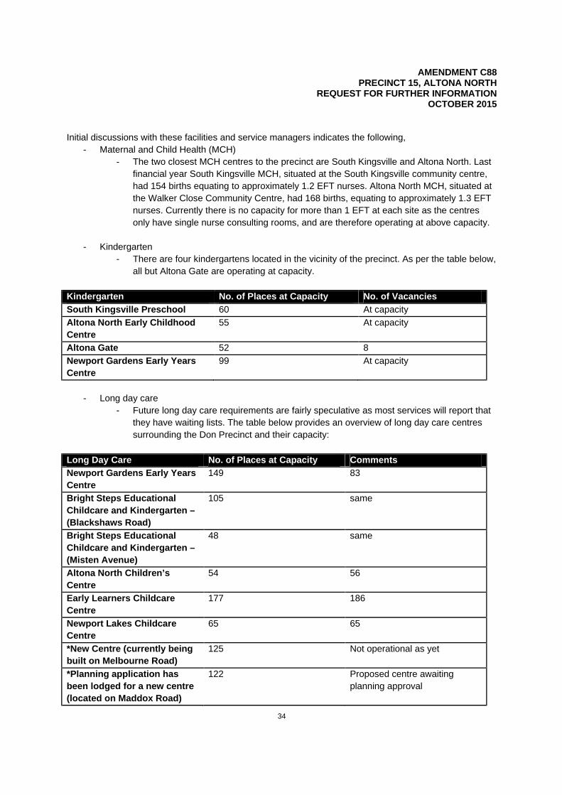
AMENDMENT C88 PRECINCT 15, ALTONA NORTH
REQUEST FOR FURTHER INFORMATION OCTOBER 2015
34
Initial discussions with these facilities and service managers indicates the following,
- Maternal and Child Health (MCH) - The two closest MCH centres to the precinct are South Kingsville and Altona North. Last
financial year South Kingsville MCH, situated at the South Kingsville community centre, had 154 births equating to approximately 1.2 EFT nurses. Altona North MCH, situated at the Walker Close Community Centre, had 168 births, equating to approximately 1.3 EFT nurses. Currently there is no capacity for more than 1 EFT at each site as the centres only have single nurse consulting rooms, and are therefore operating at above capacity.
- Kindergarten - There are four kindergartens located in the vicinity of the precinct. As per the table below,
all but Altona Gate are operating at capacity.
Kindergarten No. of Places at Capacity No. of Vacancies South Kingsville Preschool 60 At capacity Altona North Early Childhood Centre
55 At capacity
Altona Gate 52 8 Newport Gardens Early Years Centre
99 At capacity
- Long day care
- Future long day care requirements are fairly speculative as most services will report that they have waiting lists. The table below provides an overview of long day care centres surrounding the Don Precinct and their capacity:
Long Day Care No. of Places at Capacity Comments Newport Gardens Early Years Centre
149 83
Bright Steps Educational Childcare and Kindergarten – (Blackshaws Road)
105 same
Bright Steps Educational Childcare and Kindergarten – (Misten Avenue)
48 same
Altona North Children’s Centre
54 56
Early Learners Childcare Centre
177 186
Newport Lakes Childcare Centre
65 65
*New Centre (currently being built on Melbourne Road)
125 Not operational as yet
*Planning application has been lodged for a new centre (located on Maddox Road)
122 Proposed centre awaiting planning approval

AMENDMENT C88 PRECINCT 15, ALTONA NORTH
REQUEST FOR FURTHER INFORMATION OCTOBER 2015
35
It is emphasised that the information in the above tables is current and is subject to change in the future. Other potential developments in the area have not been explicitly detailed and therefore cumulative impacts have not been discussed outside the application of benchmarks to projected population forecasts as produced by ID consulting. The SIA cites ‘industry standards’ in relation to facilities such as meeting rooms, details are required as to what this standard actually is.
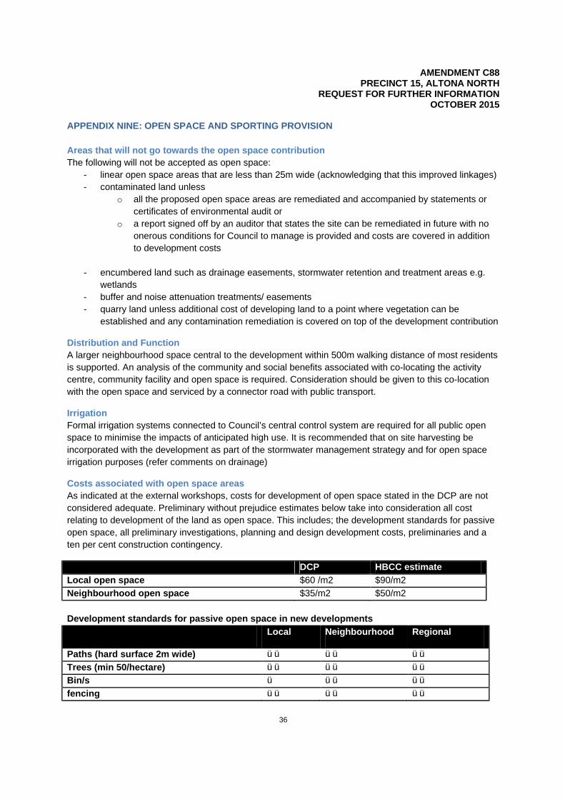
AMENDMENT C88 PRECINCT 15, ALTONA NORTH
REQUEST FOR FURTHER INFORMATION OCTOBER 2015
36
APPENDIX NINE: OPEN SPACE AND SPORTING PROVISION Areas that will not go towards the open space contribution The following will not be accepted as open space:
- linear open space areas that are less than 25m wide (acknowledging that this improved linkages) - contaminated land unless
o all the proposed open space areas are remediated and accompanied by statements or certificates of environmental audit or
o a report signed off by an auditor that states the site can be remediated in future with no onerous conditions for Council to manage is provided and costs are covered in addition to development costs
- encumbered land such as drainage easements, stormwater retention and treatment areas e.g.
wetlands - buffer and noise attenuation treatments/ easements - quarry land unless additional cost of developing land to a point where vegetation can be
established and any contamination remediation is covered on top of the development contribution
Distribution and Function A larger neighbourhood space central to the development within 500m walking distance of most residents is supported. An analysis of the community and social benefits associated with co-locating the activity centre, community facility and open space is required. Consideration should be given to this co-location with the open space and serviced by a connector road with public transport.
Irrigation Formal irrigation systems connected to Council’s central control system are required for all public open space to minimise the impacts of anticipated high use. It is recommended that on site harvesting be incorporated with the development as part of the stormwater management strategy and for open space irrigation purposes (refer comments on drainage)
Costs associated with open space areas As indicated at the external workshops, costs for development of open space stated in the DCP are not considered adequate. Preliminary without prejudice estimates below take into consideration all cost relating to development of the land as open space. This includes; the development standards for passive open space, all preliminary investigations, planning and design development costs, preliminaries and a ten per cent construction contingency.
DCP HBCC estimate Local open space $60 /m2 $90/m2 Neighbourhood open space $35/m2 $50/m2 Development standards for passive open space in new developments Local Neighbourhood Regional
Paths (hard surface 2m wide) üü üü üü Trees (min 50/hectare) üü üü üü Bin/s ü üü üü fencing üü üü üü

AMENDMENT C88 PRECINCT 15, ALTONA NORTH
REQUEST FOR FURTHER INFORMATION OCTOBER 2015
37
Local Neighbourhood Regional
Open grass areas (min dimensions/area 20m x 20m)
üü üü üü
BBQ x ü ü Paved areas ü üü üü Bike racks ü üü üü Shelter ü üü üü Seating (min 1 per 100m of path) üü üü üü signage üü üü üü lighting ü(only if
providing a link to AC or PT)
üü üü
Picnic tables ü üü üü Irrigated grass areas üü üü üü Landscaping ü üü üü Water fountain (min 1 per km square) ü üü üü Toilet x ü üü Car parking
Play space ü (up to $200k)
üü ($200k-$1m) üü ($1m +)
Point of difference and reason to visit (landscape setting or function – can be play space)
üü ($50k-150k) Min 2 reasons to visit
üü ($150-300k) 5 to 10 reasons to visit
üü (300k +) 10 + reasons to visit
Establishment maintenance (minimum 24 months)
üü üü üü
ü might have üü must have x must not have
For details and standards regarding landscape development and maintenance refer to Hobsons Bay City Council Standard Landscape Specifications

AMENDMENT C88 PRECINCT 15, ALTONA NORTH
REQUEST FOR FURTHER INFORMATION OCTOBER 2015
38
APPENDIX TEN: COMMENTS REGARDING DRAINAGE AND WATER SENSITIVE URBAN DESIGN Flood mapping analysis Flood mapping is required for:
- the current precinct to determine existing discharges into the existing drainage system - the proposed development is required to determine proposed discharges into the existing
drainage systems
A proposal is required for an onsite retention system to limit the flows into the existing drainage system to allowable limits. The allowable limits are to be determined by Council in consultation with Melbourne Water. To determine the allowable limits downstream flood mapping of Council’s drainage catchments is required. A proportion contribution by the developer to this work will be required. It is noted that will be receiving the permissible outflows for each subdivision stage to ensure each is consistent with the overall approval.
As discussed at the infrastructure and drainage workshop, the 100 year flow has to be retarded on site for the northern portion of the precinct. The northern section of the precinct drains into an area that has an existing flooding overlay. The entire northern section must be designed and constructed in such a way as to ensure that the development does not increase the flood risk to any downstream properties in a 1 in 100 Annual Exceedance Probability (AEP). Flood modelling must be provided to show this is the case prior to any designs being approved by Council. The southern portion is only required to cater for the one in ten year flood. A 300mm freeboard level is to apply over the whole precinct.
Water sensitive urban design, sustainability and on site The northern section of the precinct does not drain into an existing water treatment system and therefore best practice stormwater management must be met on site. All private property in the northern draining section must meet best practice stormwater management targets on that private property.
A WSUD/ drainage master plan is required for the precinct. Opportunities to implement storm water harvesting elements to public land should be explored, subject to contamination and maintenance related matters. As any storm water harvesting elements on public land will eventually transfer to Council ownership they must be approved at both design and construction stages by Council.
It is the responsibility of the applicant to ensure that a holistic approach to planning and sustainability are incorporated into the planning and design of the precinct. How stormwater quality issues and solutions integrate with flood mitigation, landscape design and Urban Heat Island (UHI) mitigation must be addressed and consistent in the DP, Drainage Strategy and Sustainability Plan.
Consolidated WSUD initiatives (where possible) are sought. Designs are to be approved by Council so they are manageable in the future. The development of the precinct should provide for an on-site system to limit the flows into the existing drainage system to allowable limits. The opportunity for a third pipe in the precinct and recycled water systems should be explored further with City West Water.
Water quality treatment Best practice on-site treatment of water egress into the Schutt Street drain is required to improve water quality. Limited water quality treatment is required to the south of the paisley drain network however gross pollutant traps will be required and must be approved by Council prior to installation. A stormwater management plan be prepared at this stage (and following environmental audits) with sufficient detail to indicate stormwater retention, treatment and harvesting strategies for the site and incorporated into the DP.
AMENDMENT C88 PRECINCT 15, ALTONA NORTH
REQUEST FOR FURTHER INFORMATION OCTOBER 2015
39
APPENDIX 11: COMMENTS ON THE TRACT DEVELOPMENT CONTRIBUTIONS PLAN General overarching comments The DCP can be improved by doing the following:
- proving references for all relevant inputs and assumptions including references to project costing and justification for cost apportionment
- replacing the ‘indicative’ figures provided in the infrastructure cost sheets at the appendix to the DCP with up to date information on project costs
- similarly, wording such as ‘might’ and ‘examples of’ are too ambiguous and require revision otherwise the DCP reads as though it is suggesting examples and not providing a definitive list of works
It is anticipated that the DCP will be informed by reports such as the transport impact assessment and social impact assessment and may not be finalised until these other reports are finalised. Charge area framework Details of why a more disaggregate approach to the DCP charge area was not undertaken are required as this may be a more appropriate approach than the single charge area or planning unit approach the current DCP uses. Infrastructure projects list The infrastructure projects included in the DCP will be informed by the needs of the new community. Given the level of detail required regarding who this new community will be, this project list cannot be finalised until the detail of the planning controls are confirmed. The project list currently excludes apportionment towards other infrastructure around the precinct, treating the precinct as an island site. This is not acceptable and details of use and level of apportionment appropriate are required. Matters that can be considered include improvements to access and connectivity such as the links at appendix four. Council is currently preparing a ten year capital works program. This will help provide guidance on what projects Council will be undertaking around the precinct and inform the DCP. Currently the DCP states that that ‘passive open space reserve master plans and any agreed associated works required by the development except where specified as DCP projects’ are excluded. Whereas figure four and table two of the DCP identify open space areas and include landscaping and public lighting. It is expected that the landscaping and public lighting of open space areas will be included in the DCP. Other matters to be included in the development contributions plan The DCP guidelines state that the preparation costs of the DCP document and costs associated with processing amendments to the DCP can be factored into the DCP. These should be included in the proposed DCP. Works in kind The DCP should specify that preference is for cash first and then works in kind at Council’s discretion. This needs to be inserted into the DCP.
AMENDMENT C88 PRECINCT 15, ALTONA NORTH
REQUEST FOR FURTHER INFORMATION OCTOBER 2015
40
Timing of the development contributions plan and staging and sequencing Section 4.4 of the proposed DCP does not provide sufficient details on the timing of the DCP or the delivery of infrastructure projects. An end date for the DCP requires further consideration. The timing of infrastructure projects in table six of the DCP also need to be clarified as the ‘indicative provision trigger’ column is empty. This can be done by nominating:
- a year or range of years - an event, threshold or circumstances linked to the development of the area
These can be explored further in discussion with Council. Given that the project control group is more familiar with the expectations of the various land holders in the precinct and their timelines, they are best placed to provide details of timing, triggers, staging and sequencing. Development contributions plan method A land area basis (per net developable hectare) is used for contributions instead of demand units or equivalent dwellings. The DCP assumes residential development is the primary development type and generator of demand for infrastructure. Only 1.34 hectares of non residential development is anticipated. A density of 52 dwellings per hectare is assumed throughout the DCP. Given the commentary in the main document and its appendices regarding uses on the precinct and the potential for an employment generator, the approach used by the DCP may not be appropriate. The DCP must use demand units to capture the alternative uses. As it stands, the DCP must be able to address an outcome that is either lower or higher in densities than stipulated in it. It should therefore include a clause to the following effect: ‘Council reserves the right to seek additional development contributions from a proponent as an impact mitigation payment where the project in question generates additional infrastructure demands over and above those allowed in the DCP by virtue of development density exceeding the benchmark assumed in the formulation of the DCP.’ Cost apportionment and calculations The assumptions and calculations used in the DCP require review as there are irregularities. Section 3.1 of the DCP states that contributions will be levied on an area basis (per net developable area), the reference to per dwelling contributions in table seven (calculation of costs) has the potential to cause operational confusion. Table seven also estimates the contribution per dwelling as $14,087 whereas table 11 (summary of infrastructure costs) estimates the contribution per dwelling as $13,678. Under a share of use cost apportionment model, the project costs are apportioned to the actual catchment of the facility. In the proposed DCP, the costs of the roads and recreation projects are apportioned to the DCP area, whereas 51.5 per cent of the costs of community facilities are apportioned to the DCP area. Justification for these levels of apportionment are required. Any reference documents which provide justification for these assumptions should also be referenced. Liability of contributions The liability for payments has been clarified in the DCP. The DCP has only one development type - ‘Urban development’ which is liable to pay the contributions on per net developable hectare basis. Urban development includes residential and non-residential uses. The project costs recovered by the DCP

AMENDMENT C88 PRECINCT 15, ALTONA NORTH
REQUEST FOR FURTHER INFORMATION OCTOBER 2015
41
(Table 8) are greater than the sum of property specific charges (Table 10). The DCP calculations and property specific charges require review. Administration of development contribution funds The DCP has no provision to cover the scenario where Council (as the development agency) achieves saving, or resolves not to proceed with infrastructure projects. If Council has ‘unspent funds’ from contributions towards infrastructure projects, it must ensure compliance with section 46Q of the Planning and Environment Act 1987. Therefore the DCP should include words to the following effect: ‘Should Council accumulate additional funds over and above those estimated in the DCP, these will be deployed in the supply of additional or better infrastructure in the DCP area. Should Council determine not to proceed with any DCP infrastructure item, Council will seek approval from the Minister for the substation of another infrastructure project that provides benefits to a similar area.’ Details are required as to what takes place if the valuation cited at 4.3 is not agreed to by parties and details of what the ‘agreed method’ are also required. Development contributions plan review It is anticipated that the DCP will be revised and updated every ten years. However an administrative review at the three year mark is suggested.