Embed Size (px)
Citation preview
DISTRICT GROUND WATER BROCHURE
AMBEDKAR NAGAR DISTRICT UTTAR PRADESH
Compiled by
Vikas Ranjan
Scientist C
Central Ground Water Board Northern Region
Lucknow January, 2014
DISTRICT GROUND WATER BROCHURE OF AMBEDKAR NAGAR DISTRICT, UP
Compiled by Vikas Ranjan
Scientist C (AAP 2012-13)
CONTENTS SECTION TITLE PAGE NO.
DISTRICT AT A GLANCE 1. INTRODUCTION 1.1 Location, Extent & Population ……………………………...................1 1.2 Administrative Setup ……………………………...................1 1.3 Agriculture, Irrigation and Crops ……………………………...................2 1.4 Industries ……………………………...................5
2. CLIMATE & RAINFALL ……………………………...................5 3. DRAINAGE, SOIL, GEOMORPHOLOGY & GEOLOGY 3.1 Drainage & Soil ……………………………...................6 3.2 Geomorphology ……………………………...................7 3.3 Geology ……………………………...................7
4. GROUND WATER SCENARIO 4.1 Hydrogeology .……………………………...................8 4.2 Depth to Water Level ...…………………………….................9 4.3 Long-term Water Level Trend ……………………………....................9 4.4 Ground Water Quality …………………………….................10 4.5 Status of Ground Water Development …………………………….................11 4.6 Dynamic Ground Water Resources …………………………….................12
5. GROUND WATER RELATED ISSUES AND PROBLEMS …………………………….................12
6. GROUND WATER MANAGEMENT STRATEGY …………………………….................13
7. AWARENESS AND TRAINING ACTIVITY …………………………….................13
8. AREA NOTIFIED BY CGWA …………………………….................13
9. RECOMMENDATIONS …………………………….................13
BIBLIOGRAPHY/ REFERENCES …………………………….................14
APPENDICES
I Summarized hydrogeological results of exploratory drilling by CGWB in Ambedkar Nagar district.
II Block-wise salient figures of Estimation of Dynamic GW Resources as on 31.3.2009.
PLATES
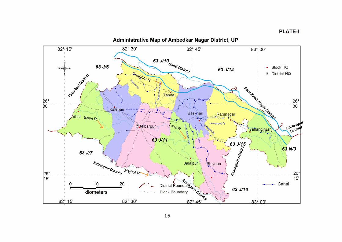
I Administrative Map of Ambedkar Nagar district, UP II Hydrogeology of Ambedkar Nagar District, UP III Pre-monsoon Depth to Water Levels (2011), Ambedkar Nagar District, UP IV Post-monsoon Depth to Water Levels (2011), Ambedkar Nagar District, UP V Dynamic GW Resources (as on 31.3.2009) of Ambedkar Nagar District, UP
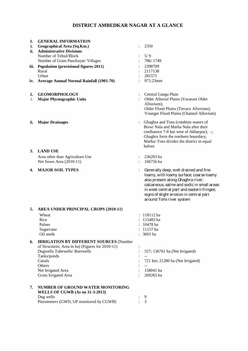
DISTRICT AMBEDKAR NAGAR AT A GLANCE
1. GENERAL INFORMATION i. Geographical Area (Sq.Km.) : 2350 ii. Administrative Divisions
Number of Tehsil/Block Number of Gram Panchayat/ Villages
: :
5/ 9 786/ 1749
iii. Population (provisional figures-2011) Rural Urban
: : :
2398709 2117138 281571
iv. Average Annual Normal Rainfall (1901-70) : 973.23mm
2. GEOMORPHOLOGY : Central Ganga Plain i. Major Physiographic Units : Older Alluvial Plains (Varanasi Older
Alluvium); Older Flood Plains (Terrace Alluvium); Younger Flood Plains (Channel Alluvium)
ii. Major Drainages : Ghaghra and Tons (combine waters of Biswi Nala and Marha Nala after their confluence 7-8 km west of Akbarpur); –; Ghaghra form the northern boundary; Marha/ Tons divides the district in equal halves
3. LAND USE Area other than Agriculture Use
Net Sown Area (2010-11) : :
236203 ha 166756 ha
4. MAJOR SOIL TYPES : Generally deep, well drained and fine loamy, with loamy surface; coarse loamy also present along Ghaghra river; calcareous, saline and sodic in small areas in west-central part and eastern fringes; signs of slight erosion in central part around Tons river system
5. AREA UNDER PRINCIPAL CROPS (2010-11) Wheat
Rice Pulses Sugarcane Oil seeds
: : : : :
118112 ha 115483 ha 10478 ha 11157 ha 3601 ha
6. IRRIGATION BY DIFFERENT SOURCES (Number of Structures; Area in ha) (Figures for 2010-11) Dugwells Tubewells/ Borewells Tanks/ponds Canals Others Net Irrigated Area Gross Irrigated Area
: : : : : : :
557; 136761 ha (Net Irrigated) -- 721 km; 21280 ha (Net Irrigated) -- 158041 ha 269265 ha
7. NUMBER OF GROUND WATER MONITORING WELLS OF CGWB (As on 31-3-2013) Dug wells Piezometers (GWD, UP monitored by CGWB)
: :
9 3
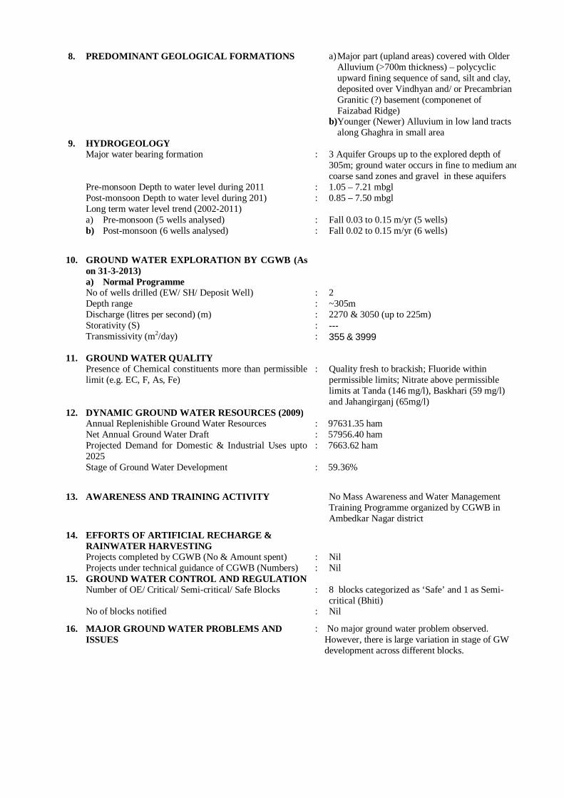
8. PREDOMINANT GEOLOGICAL FORMATIONS a) Major part (upland areas) covered with Older Alluvium (>700m thickness) – polycyclic upward fining sequence of sand, silt and clay, deposited over Vindhyan and/ or Precambrian Granitic (?) basement (componenet of Faizabad Ridge)
b)Younger (Newer) Alluvium in low land tracts along Ghaghra in small area
9. HYDROGEOLOGY Major water bearing formation Pre-monsoon Depth to water level during 2011 Post-monsoon Depth to water level during 201) Long term water level trend (2002-2011) a) Pre-monsoon (5 wells analysed) b) Post-monsoon (6 wells analysed)
: : : : :
3 Aquifer Groups up to the explored depth of 305m; ground water occurs in fine to medium and coarse sand zones and gravel in these aquifers 1.05 – 7.21 mbgl 0.85 – 7.50 mbgl Fall 0.03 to 0.15 m/yr (5 wells) Fall 0.02 to 0.15 m/yr (6 wells)
10. GROUND WATER EXPLORATION BY CGWB (As on 31-3-2013) a) Normal Programme No of wells drilled (EW/ SH/ Deposit Well) Depth range Discharge (litres per second) (m) Storativity (S) Transmissivity (m2/day)
: : : : :
2 ~305m 2270 & 3050 (up to 225m) --- 355 & 3999
11. GROUND WATER QUALITY Presence of Chemical constituents more than permissible limit (e.g. EC, F, As, Fe)
:
Quality fresh to brackish; Fluoride within permissible limits; Nitrate above permissible limits at Tanda (146 mg/l), Baskhari (59 mg/l) and Jahangirganj (65mg/l)
12. DYNAMIC GROUND WATER RESOURCES (2009) Annual Replenishible Ground Water Resources Net Annual Ground Water Draft Projected Demand for Domestic & Industrial Uses upto 2025 Stage of Ground Water Development
: : : :
97631.35 ham 57956.40 ham 7663.62 ham 59.36%
13. AWARENESS AND TRAINING ACTIVITY No Mass Awareness and Water Management Training Programme organized by CGWB in Ambedkar Nagar district
14. EFFORTS OF ARTIFICIAL RECHARGE & RAINWATER HARVESTING Projects completed by CGWB (No & Amount spent) Projects under technical guidance of CGWB (Numbers)
: :
Nil Nil
15. GROUND WATER CONTROL AND REGULATION Number of OE/ Critical/ Semi-critical/ Safe Blocks No of blocks notified
: :
8 blocks categorized as ‘Safe’ and 1 as Semi-critical (Bhiti) Nil
16. MAJOR GROUND WATER PROBLEMS AND ISSUES
: No major ground water problem observed. However, there is large variation in stage of GW development across different blocks.
1
Ambedkar Nagar District
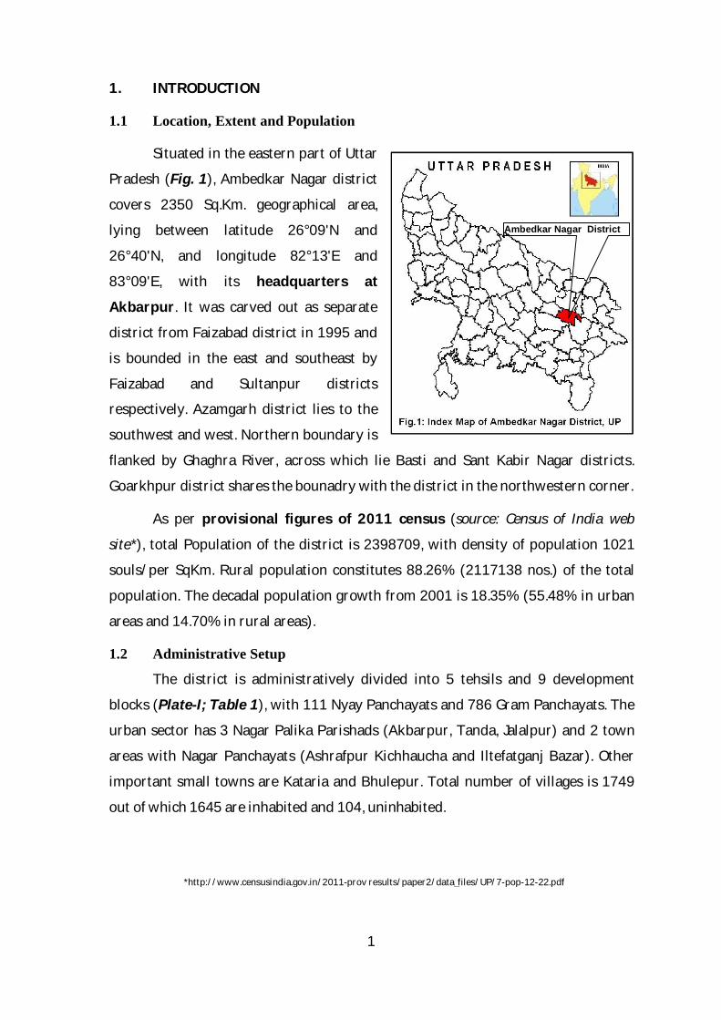
1. INTRODUCTION
1.1 Location, Extent and Population
Situated in the eastern part of Uttar
Pradesh (Fig. 1), Ambedkar Nagar district
covers 2350 Sq.Km. geographical area,
lying between latitude 26°09'N and
26°40'N, and longitude 82°13'E and
83°09'E, with its headquarters at
Akbarpur. It was carved out as separate
district from Faizabad district in 1995 and
is bounded in the east and southeast by
Faizabad and Sultanpur districts
respectively. Azamgarh district lies to the
southwest and west. Northern boundary is
flanked by Ghaghra River, across which lie Basti and Sant Kabir Nagar districts.
Goarkhpur district shares the bounadry with the district in the northwestern corner.
As per provisional figures of 2011 census (source: Census of India web
site*), total Population of the district is 2398709, with density of population 1021
souls/per SqKm. Rural population constitutes 88.26% (2117138 nos.) of the total
population. The decadal population growth from 2001 is 18.35% (55.48% in urban
areas and 14.70% in rural areas).
1.2 Administrative Setup
The district is administratively divided into 5 tehsils and 9 development
blocks (Plate-I; Table 1), with 111 Nyay Panchayats and 786 Gram Panchayats. The
urban sector has 3 Nagar Palika Parishads (Akbarpur, Tanda, Jalalpur) and 2 town
areas with Nagar Panchayats (Ashrafpur Kichhaucha and Iltefatganj Bazar). Other
important small towns are Kataria and Bhulepur. Total number of villages is 1749
out of which 1645 are inhabited and 104, uninhabited.
*http://www.censusindia.gov.in/2011-prov results/paper2/data_files/UP/7-pop-12-22.pdf
2
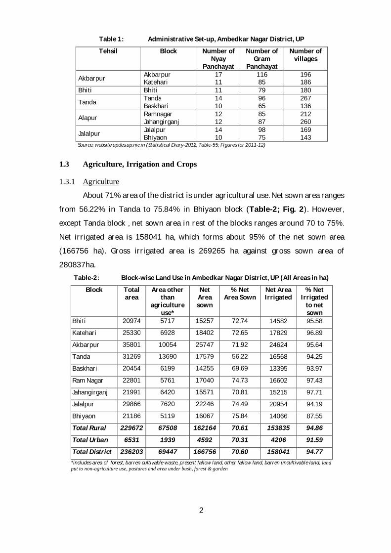
Table 1: Administrative Set-up, Ambedkar Nagar District, UP
Tehsil Block Number of Nyay
Panchayat
Number of Gram
Panchayat
Number of villages
Akbarpur Akbarpur Katehari
17 11
116 85
196 186
Bhiti Bhiti 11 79 180
Tanda Tanda Baskhari
14 10
96 65
267 136
Alapur Ramnagar Jahangirganj
12 12
85 87
212 260
Jalalpur Jalalpur Bhiyaon
14 10
98 75
169 143
Source: website updes.up.nic.in (Statistical Diary-2012, Table-55; Figures for 2011-12)
1.3 Agriculture, Irrigation and Crops
1.3.1 Agriculture
About 71% area of the district is under agricultural use. Net sown area ranges
from 56.22% in Tanda to 75.84% in Bhiyaon block (Table-2; Fig. 2). However,
except Tanda block , net sown area in rest of the blocks ranges around 70 to 75%.
Net irrigated area is 158041 ha, which forms about 95% of the net sown area
(166756 ha). Gross irrigated area is 269265 ha against gross sown area of
280837ha. Table-2: Block-wise Land Use in Ambedkar Nagar District, UP (All Areas in ha)
Block
Total area
Area other than
agriculture use*
Net Area sown
% Net Area Sown
Net Area Irrigated
% Net Irrigated
to net sown
Bhiti 20974 5717 15257 72.74 14582 95.58
Katehari 25330 6928 18402 72.65 17829 96.89
Akbarpur 35801 10054 25747 71.92 24624 95.64
Tanda 31269 13690 17579 56.22 16568 94.25
Baskhari 20454 6199 14255 69.69 13395 93.97
Ram Nagar 22801 5761 17040 74.73 16602 97.43
Jahangirganj 21991 6420 15571 70.81 15215 97.71
Jalalpur 29866 7620 22246 74.49 20954 94.19
Bhiyaon 21186 5119 16067 75.84 14066 87.55
Total Rural 229672 67508 162164 70.61 153835 94.86
Total Urban 6531 1939 4592 70.31 4206 91.59
Total District 236203 69447 166756 70.60 158041 94.77 *includes area of forest, barren cultivable waste, present fallow land, other fallow land, barren uncultivable land, land put to non-agriculture use, pastures and area under bush, forest & garden
3
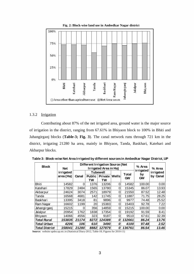
1.3.2 Irrigation
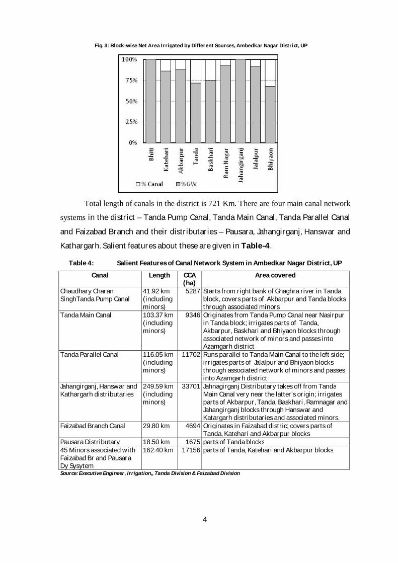
Contributing about 87% of the net irrigated area, ground water is the major source
of irrigation in the district, ranging from 67.61% in Bhiyaon block to 100% in Bhiti and
Jahangirganj blocks (Table-3; Fig. 3). The canal network runs through 721 km in the
district, irrigating 21280 ha area, mainly in Bhiyaon, Tanda, Baskhari, Katehari and
Akbarpur blocks.
Table 3: Block-wise Net Area Irrigated by different sources in Ambedkar Nagar District, UP
Block
Net irrigated area (Ha)
Different Irrigation Source (Net Irrigated Area in Ha) % Area
irrigated by
GW
% Area irrigated by Canal Canal
Tubewell Wells Total
GW Public TW
Private TW
Bhiti 14582 0 1376 13206 0 14582 100.00 0.00 Katehari 17829 2484 1565 13780 0 15345 86.07 13.93 Akbarpur 24624 3074 2571 18979 0 21550 87.52 12.48 Tanda 16568 4681 142 11745 0 11887 71.75 28.25 Baskhari 13395 3418 81 9896 0 9977 74.48 25.52 Ram Nagar 16602 1199 20 15383 0 15403 92.78 7.22 Jahangirganj 15215 0 356 14859 0 15215 100.00 0.00 Jalalpur 20954 1762 1838 17354 0 19192 91.59 8.41 Bhiyaon 14066 4556 323 9187 0 9510 67.61 32.39 Total Rural 153835 21174 8272 124389 0 132661 86.24 13.76 Total Urban 4206 106 610 3490 0 4100 97.48 2.52 Total District 158041 21280 8882 127879 0 136761 86.54 13.46
Source: website updes.up.nic.in (Statistical Diary-2012, Table-18; Figures for 2010-11)
Fig. 2: Block-wise land use in Ambedkar Nagar district
4
Total length of canals in the district is 721 Km. There are four main canal network
systems in the district – Tanda Pump Canal, Tanda Main Canal, Tanda Parallel Canal
and Faizabad Branch and their distributaries – Pausara, Jahangirganj, Hanswar and
Kathargarh. Salient features about these are given in Table-4.
Table 4: Salient Features of Canal Network System in Ambedkar Nagar District, UP
Canal Length CCA (ha)
Area covered
Chaudhary Charan SinghTanda Pump Canal
41.92 km (including minors)
5287 Starts from right bank of Ghaghra river in Tanda block, covers parts of Akbarpur and Tanda blocks through associated minors
Tanda Main Canal 103.37 km (including minors)
9346 Originates from Tanda Pump Canal near Nasirpur in Tanda block; irrigates parts of Tanda, Akbarpur, Baskhari and Bhiyaon blocks through associated network of minors and passes into Azamgarh district
Tanda Parallel Canal 116.05 km (including minors)
11702 Runs parallel to Tanda Main Canal to the left side; irrigates parts of Jalalpur and Bhiyaon blocks through associated network of minors and passes into Azamgarh district
Jahangirganj, Hanswar and Kathargarh distributaries
249.59 km (including minors)
33701 Jahnagirganj Distributary takes off from Tanda Main Canal very near the latter’s origin; irrigates parts of Akbarpur, Tanda, Baskhari, Ramnagar and Jahangirganj blocks through Hanswar and Katargarh distributaries and associated minors.
Faizabad Branch Canal 29.80 km 4694 Originates in Faizabad distric; covers parts of Tanda, Katehari and Akbarpur blocks
Pausara Distributary 18.50 km 1675 parts of Tanda blocks 45 Minors associated with Faizabad Br and Pausara Dy Sysytem
162.40 km 17156 parts of Tanda, Katehari and Akbarpur blocks
Source: Executive Engineer, Irrigation,, Tanda Division & Faizabad Division
Fig. 3: Block-wise Net Area Irrigated by Different Sources, Ambedkar Nagar District, UP
5
1.3.3 Crops
Wheat is grown in the maximum area of the district (~42% of gross sown
area), followed by rice (~41% of gross sown area). Principal crop during Kharif is
paddy and that during Rabi, wheat. Millet, maize and jwar are also sown in small
areas during Kharif, and pulses and oil seeds during Rabi. Other crops of minor
importance are sugarcane, potato etc. Cropping pattern is given in Table-5.
Table 5: Cropping Pattern in District Ambedkar Nagar, UP (2010-11)
Crop Area (Ha)
% of Gross Sown Area
Irrigated (% of sown Area)
Wheat 118112 ~42% 100% Rice 115483 ~41% ~100% Pulses 10478 3.7% ~66% Sugarcane 11157 ~4% 100% Potato 4263 ~1.5% 100% Oil Seeds 3601 ~1.3% ~100% Other Vegetables 6764 2.4% ~97%
Source: website updes.up.nic.in (Statistical Diary-2012, Table-19; Figures for 2010-11)
1.4 Industries
There is as such no major industrial area in the district. A few large-scale
industries/ Public Sector Undertakings, as well as micro & small Scale Enterprise
exist in the district (Table-6). Tanda City is famous for Tanda terri-cotton cloths.
Here, the main business depends on hand loom and power loom cloths. Table-6: Main Industries in Ambedkar Nagar District
Scale of Industry Industry Large Scale Industries/ Public Sector Undertakings
National Therma Power Corporation, Tanda. J.P. Cemnet, Tanda Akbarpur Sugar Mill at Mijhaura (10km from Akbarpur).
Micro & small Enterprises
Mainly agro based. Some other such units are cotton textile, woolen, silk and artficial threads, ready-made garments and embroidery; wood/ wooden based furnitures; paper & paper products; leather based; chemical/chemical based etc.
Source: District Industrial Profile of Ambedkar Nagar District, UP by MSME Development Institute, Allahabad, Ministry of Micro, Small & Medium Enterprise, Government of India
2. CLIMATE AND RAINFALL
With hot and dry summers, humid monsoon season and dry winters, and
normal annual rainfall (1901-70) averaged over 3 raingauge stations existing in the
district as 973.23mm, the district comes under sub-tropical sub-humid climate zone.
The nearest Observatory is located in Faizabad. The temperature varies from 8.1°C
6
to 24.80C in winters and 24.00C to 39.60C in summers. During cold-waves the
temperature may plunge considerably. May is the hottest month of the year and
January, the coldest, with mean daily maximum temperature during the former
being 39.60C and that in latter, 23.40C. The mean daily minimum temperatures
during these months are 24.00C and 8.10C respectively. The southwest monsoon is
active from mid-June to September/ early-October, with maximum rainfall (~93%)
taking place during this period, August being the wettest month. There is average 50
rainy days (days with rainfall of 2.5 mm or more) in a year. Average humidity
remains considerably high from July to September (76% - 87%) and is highest
during the month of August.
3. DRAINAGE, SOIL, GEOMORPHOLOGY & GEOLOGY
3.1 Drainage & Soil
Ghaghra river, flowing in southeasterly direction drains the northern part of
the district, forming its northern boundary. It is one of the largest and perennial
rivers of Uttar Pradesh having width more than 5 kms at places. The banks on either
side are fairly steep along its entire course. Another main drainage system is that of
the Tons river, the name given to the combined water of Marha and Biswi Nalas after
their confluence about 7-8 km west of Akbarpur. The river runs almost parallel to
Ghaghra and flows into Azamgarh district. Together, the Marha Nala and Tons river
(after junction) divide the district into almost equal halves.
The Soil Map of UP published by National Bureau of Soil Sciences and Land
Use Planning (NBSS & LUP, 2004) shows that in almost entire district, the soil is
mainly deep, well or moderately well drained and fine loamy, with loamy surface. In
the narrow belt along Ghaghra, the coarse loamy soil (Balua) is also present along
with soil of the above nature. In west-central parts, however, the soil is moderately
well or poorly drained, exhibiting calcareous nature and is slightly saline and sodic.
In a small portion in eastern fringes the soil is poorly drained, fine loamy and
calcareous and is associated with slightly saline and sodic soils. At places, poorly
drained, calcareous and/ or fine silty soils are also present in minor proportion
along with main type of soil. Soil in the central parts, i.e around Tons river system
shows signs of slight erosion. In broader terms, Varanasi Plain has Older Alluvial Soil
(Alfisols), while Terrace Alluvium has Newer Alluvial Soil (Entisols) (GSI, 2001).
7
3.2 Geomorphology
Ambedkar Nagar district forms part of Central Ganga Plains, having
monotonous topography, with elevations ranging between 83-92 mamsl and gentle
southeasterly slope. Geomorphologically, the terrain can be differentiated into
upland and lowland (GSI, 2001). The upland known as Varanasi Plain, lying in
Ganga-Ghaghra interfluves is the oldest geomorphic unit and occupies major part of
the district. The ground of Varanasi Plain is silty to clayey, slopes gently towards
southeast, and has scars of relict fluvial features in the form of tals and
palaeochannels. The lowland lies along Ghaghra river and is divisible into Older
Flood Plain (Terrace Plain) and Active Flood Plain (Channel Plain). The Terrace Plain
is of depositional type and preserves the sediments deposited by the river during its
process of incision. Active Flood Plain is restricted to the present day banklines of
the river in the form of point/ channel/ lateral bars and is wide and sandy.
3.3 Geology
The district exposes Quaternary sediments (GSI, op. cit.), which can be
differentiated into Older Alluvium (OA) and Newer Alluvium (NA). The OA consists
of oxidized, brown, yellow and khaki coloured sediments whereas the NA comprises
unoxidsed, grey and khaki coloured sediments. The OA, designated as Varanasi
Alluvium (Middle to Late Pliestocene age), contains polycyclic sequence of silt and
clay with kankar layers and subordinate beds/ lenses of micaceous sand, deposited
over inferred basement of Bundelkhand Granite/ Vindhyans as components of
‘Faizabad Ridge’ (Khan et al., 1992). It is dominantly argillaceous in the upper part
and arenaceous in the lower levels (Khanna et al., 1990). Central Ground Water
Board has drilled exploratory wells only down to 305m in the southern part of the
district. However, the boreholes drilled by CGWB down to 752m at Ranipur Gharwal
in adjoining Faizabad district to the west and down to 755m at Paendapur in
Azamgarh district to the south did not encounter basement, indicating that OA is
more than 700m thick in this part. Thin interbeds of calcareous sandstones and
compacted kankar beds, punctuating the stratigraphic column at various levels,
represent minor breaks in sedimentation and suggest locally pulsating
palaeoclimatic conditions from warm humid to warm arid at times (Khan et al.,
op.cit.). The NA (Holocene age) occupies lowland and is divisible into Terrace
8
Alluvium and Channel Alluvium. The Terrace Alluvium consists of interbedded
sequence of grey to khaki, micaceous, fine to coarse grained, immature sand, silt and
clay and is well developed along Ghaghra river. The Channel Alluvium includes loose
sand (grey, micaceous, fine to medium grained) of point/ channel bars and mud flats
of flood plain of Ghaghra river. Thin layers of mud occupying tals/ palaeochannels
are considered as homotaxial to Newer Alluvium. Generalized stratigraphic
sequence is given in Table-7.
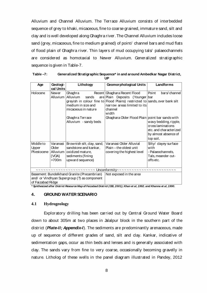
Table –7: Generalized Stratigraphic Sequence* in and around Ambedkar Nagar District, UP
Age Geologi-cal Units
Lithology Geomorphological Units Landforms
Holocene Newer Alluvium
Ghaghra Recent Alluvium sands are greyish in colour fine to medium in size and micaceous in nature
Ghaghara Recent Flood Plain Deposits (Younger Flood Plains) restricted to narrow areas limited to its channel width
Point bars/channel bar sands, over bank silt
Ghaghra Terrace Alluvium - sandy beds
Ghaghara Older Flood Plain point bar sands with wavy bedding, ripple, cross laminations etc. and characterized by almost absence of top soil.
Middle to Upper Pliestocene
Varanasi Older Alluvium (VOA) >700m
Brownish silt, clay, sand, sandstone and kankar, oxidized mature, sediments (fining upward sequence)
Varanasi Older Alluvial Plain – the oldest unit covering the highest level
Silty/ clayey surface with - Palaeochannels, Tals, meander cut-offs etc.
~~~~~~~~~~~~~~~~~~~~~~~~ Unconformity~~~~~~~~~~~~~~~~~~~~~~~~ Basement: Bundelkhand Granite (Precambrian) and/ or Vindhyan Supergroup (?) as component of Faizabad Ridge
Not exposed in the area
* Synthesized after District Resource Map of Faizabad District (GSI, 2001); Khan et al, 1992. and Khanna et al, 1990.
4. GROUND WATER SCENARIO
4.1 Hydrogeology
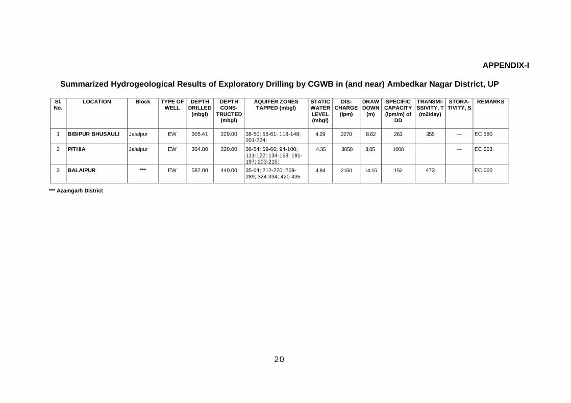
Exploratory drilling has been carried out by Central Ground Water Board
down to about 305m at two places in Jalalpur block in the southern part of the
district (Plate-II; Appendix-I). The sediments are predominantly arenaceous, made
up of sequence of different grades of sand, silt and clay. Kankar, indicative of
sedimentation gaps, occur as thin beds and lenses and is generally associated with
clay. The sands vary from fine to very coarse, occasionally becoming gravelly in
nature. Litholog of these wells in the panel diagram illustrated in Pandey, 2012
9
depicts three aquifer systems separated by thick clay beds. Deep exploratory drilling
(~750m) in adjoining Faizabad and Azamgarh districts also suggests that multiple
aquifer system exists in the area. Exploratory well drilled down to 582m at Balaipur
(Appendix-I) near the southern boundary in Azamgarh district encounters thick clay
beds in the depth range of 72-519m, with thin intercalations of sand beds (Singh,
2005). Sand mixed with gravel form the principal aquifers.
The 2 wells drilled in the district have been constructed up to 229m,
collectively tapping Aquifer Group I & II. These wells have yielded 2270 to 3050 lpm
water. Summary of the EWs drilled in the district is given in Table-8
Table-8: Exploratory Drilling by CGWB in Ambedkar Nagar district, UP (Summarized results in Appendix-I)
Number of EW
Depth Range (mbgl)
Yields (lpm)
Draw-downs (m)
Transmissivity (m2/day)
2 304.80-305.41 2270 - 3050 3.05 – 8.62 355 – 3999
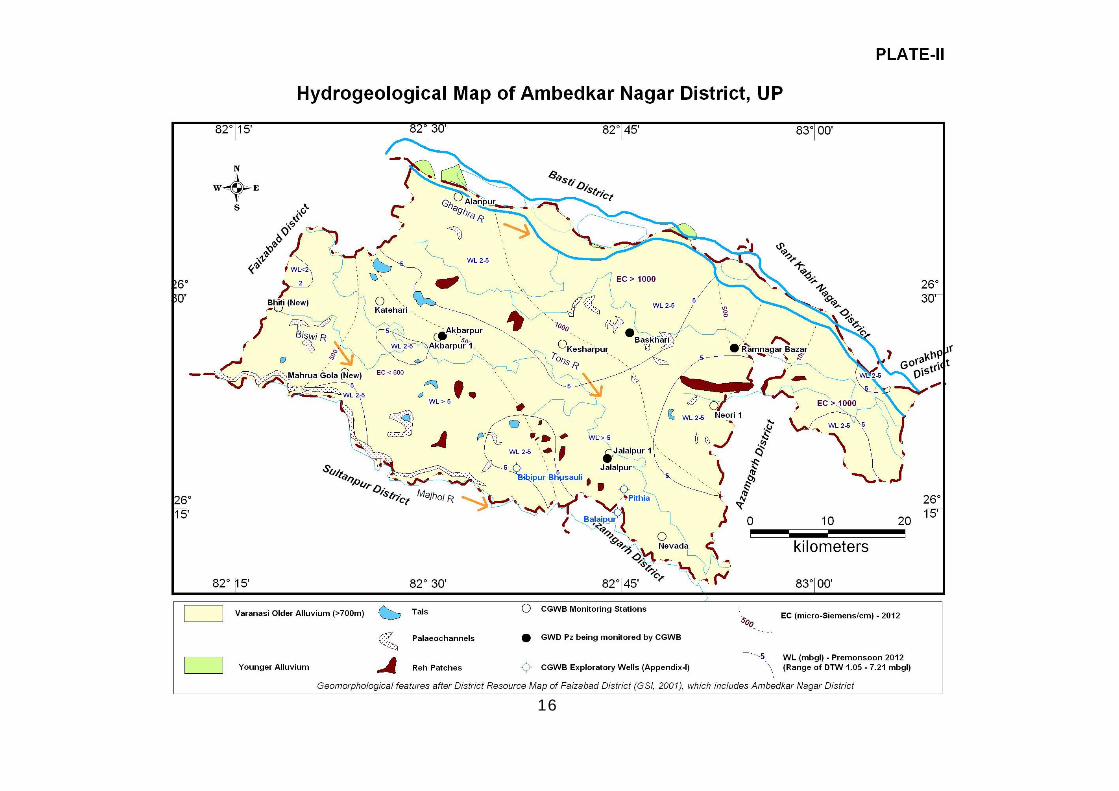
Hydrogeological map of the district is presented in Plate-II.
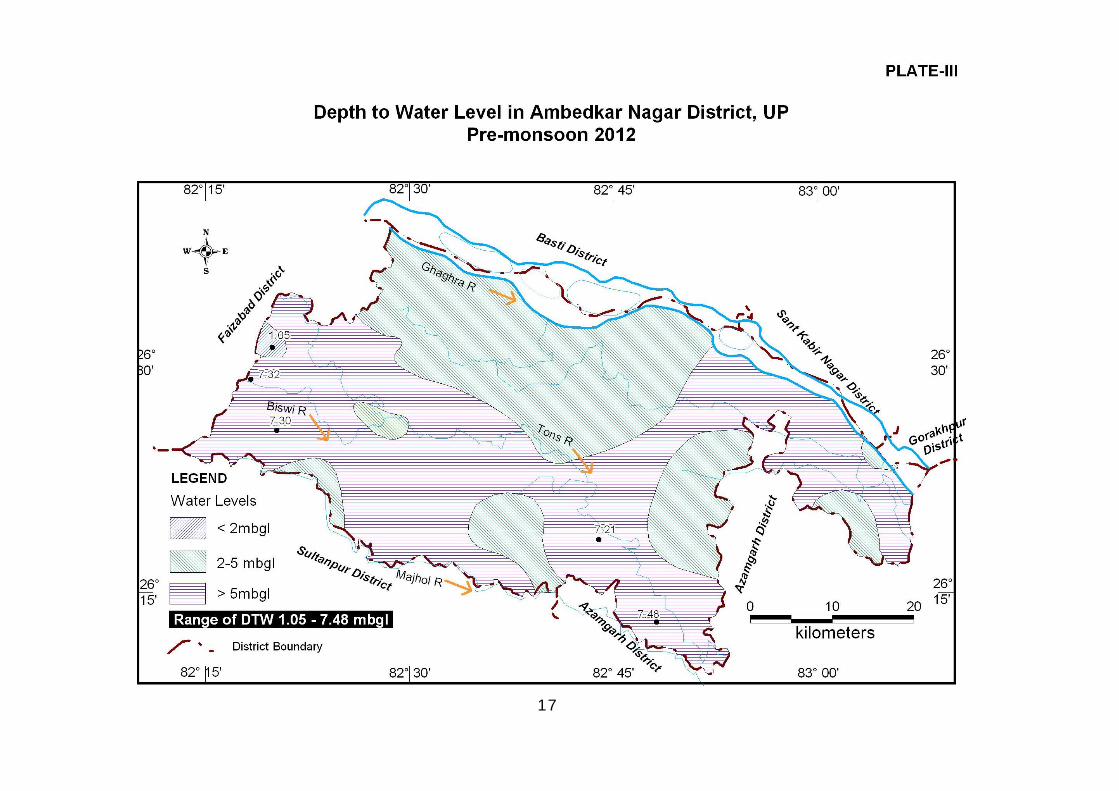
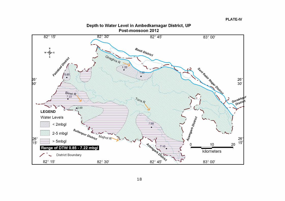
4.2 Depth to Water Level
As per data of Ground Water Monitoring Stations of CGWB and GWD, UP for
2012, water levels in the district range from 1.05 to 7.48 mbgl during pre-monsoon,
with majority of wells falling in the range of 3-7 mbgl. During post-monsoon, water
levels range from 0.85 to 7.22 mbgl, with large number of wells having water levels
between 2-6 mbgl. Depth to water level contours for pre- and post-monsoon 2012
are presented in Plate-III & IV respectively.
4.3 Long-term Water Level Trend
Analysis of water levels for the period 2003-12 in respect of CGWB
monitoring wells existing in the district shows slightly declining trends, with range
of decline as 0.03-0.15 m/yr during pre-monsoon and 0.02-0.15 m/yr during post-
monsoon. Maximum decline has been observed at Bhiti, both during pre-monsoon
(0.15 m/yr) and post-monsoon (0.15 m/yr).
10
4.4 Ground Water Quality
4.4.1 Quality of Ground Water in Phreatic Aquifer
Central Ground water Board monitors ground water quality of phreatic
aquifer through analysis of samples collected once a year (one sample from each
block). Ground Water samples collected from 9 blocks of the district during 2012
show Electrical Conductivity (EC) in the range of 260-1250 µ-Siemens/cm, with EC
values more than 1000µ-S/cm at 4 places (Tanda, Baskahri, Jahangirganj and
Bhiyaon), indicating that ground water is fresh to brackish in the district. Variation
in EC over the area is illustrated through EC contours on Hydrogeological Map of the
district (i.e Plate-II). Ground water is of slightly alkaline nature as suggested by pH
values ranging from 7.81 to 8.70, with only one sample having pH value less than 8.
Total hardness (as CaCo3) ranges from 180-380 mg/l. Fluoride is within
permissible limits (1.5 mg/l) in all the samples, whereas Nitrate above permissible
limit (45 mg/l) has been found at 3 places ( Tanda – 146 mg/L; Baskhari – 59 mg/L
& Jahangirganj – 65 mg/L).
During a survey carried out by UP Jal Nigam for arsenic in ground water in 4
blocks of the district, namely – Tanda, Baskhari, Ramnagar and Jahangirganj, arsenic
has been detected in some of the GW samples from 3 blocks except Jahnagirganj,
with arsenic concentrations above 10 ppb also encountered in rare instances
(Table-9). Arsenic above 50ppb was not found in any sample (Total 2330
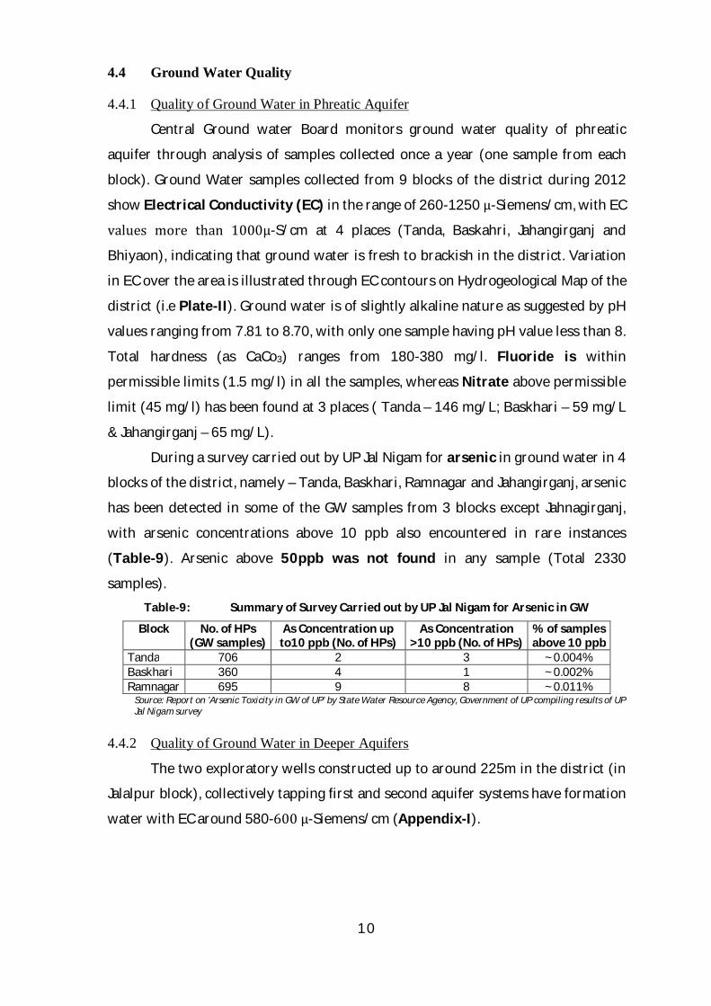
samples). Table-9: Summary of Survey Carried out by UP Jal Nigam for Arsenic in GW
Block No. of HPs (GW samples)
As Concentration up to10 ppb (No. of HPs)
As Concentration >10 ppb (No. of HPs)
% of samples above 10 ppb
Tanda 706 2 3 ~0.004% Baskhari 360 4 1 ~0.002% Ramnagar 695 9 8 ~0.011%
Source: Report on ’Arsenic Toxicity in GW of UP’ by State Water Resource Agency, Government of UP compiling results of UP Jal Nigam survey
4.4.2 Quality of Ground Water in Deeper Aquifers
The two exploratory wells constructed up to around 225m in the district (in
Jalalpur block), collectively tapping first and second aquifer systems have formation
water with EC around 580-600 µ-Siemens/cm (Appendix-I).

11
4.5 Status of Ground Water Development
About 71% area of the district is under agricultural use, with paddy and
wheat grown on large scale. Net irrigated area is about 95% of the net sown area, of
which 87% contribution comes from ground water. Although there is fairly strong
canal network in the district, irrigation is mainly ground water dependent
throughout the district (Table-3 & 10). This is due to easy access to ground water as
water levels are not deep and ground water is directly under control of individual
farmer/ user.
Table 10: Block-wise status of sources of irrigation in Ambedkar Nagar district
Block Canal length (km)
Govt. tube-well (No.)
Perma- nent
wells (No.)
Rahat (No.)
Pumpsets Ground pumpset
(No.)
Bhiti 0 112 16 0 1285 4507 13 5805 0 Katehari 102 69 14 0 641 5680 500 6821 0 Akbarpur 40 79 16 0 1371 9343 353 11067 0 Tanda 181 17 11 0 607 7041 116 7764 0 Baskhari 91 10 13 0 368 4872 28 5268 0 Ram Nagar 112 18 12 0 325 6819 61 7205 0 Jahangirganj 33 33 11 0 380 5459 73 5912 0 Jalalpur 59 59 15 0 951 8250 109 9310 0 Bhiyaon 103 29 13 0 443 4506 41 4990 0 Total Rural 721 426 121 0 6371 56477 1294 64142 0 Total Urban - 10 0 0 0 0 0 0 0 Total District 721 436 121 0 6371 56477 1294 64142 0
Source: website updes.up.nic.in (Statistical Diary-2012, Table-23; Figures for 2010-11)
Drinking water requirement of the district is met by UP Jal Nigam through
tubewells (Piped Water Supply Scheme) and India Mark II hand pumps, with per
capita demand considered as 70 lpcd (rate of water supply 70 lpcd + 15%). As per
Statistical Diary, 2012, 1645 villages have India Mark II hand pumps, benefiting a
population of 2528870. Rural Piped Water Supply Schemes have 4 tubewells
catering to 29123 population in 3 villages of Jalalpur block (Suhurpur, Nagpur &
Manguradila villages ) and 1 village of Bhiyaon block (Bhiyaon) (source: office of
Executive Engineer, UPJN, Ambedkar Nagar). In urban areas, water supply is through
743 HPs and 25 TWs in 5 towns (Akbarpur, Tanda, Jalalpur, Ashrafpur Kichaucha
and Iltefatganj), catering to population of 173795 (Source as above). Out of the 25
tube wells, 19 are located in Tanda and Akbarpur town alone (10 and 9
respectively).
12
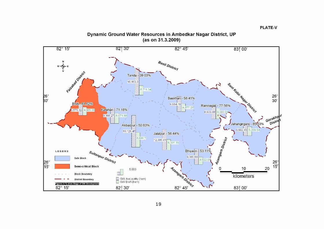
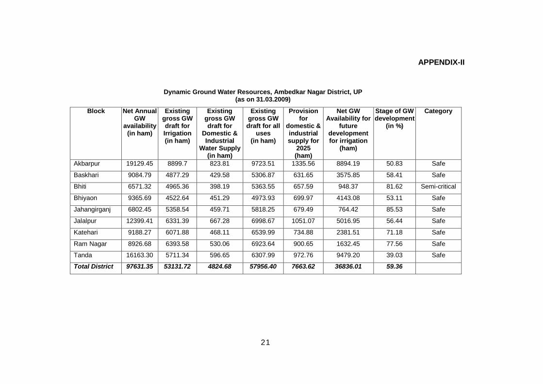
4.6 Dynamic Ground Water Resources (as on 31.3.2009)
As per estimation of dynamic (replenishible) ground water resource of
Ambedkar Nagar district (as on 31.3.2009), all the blocks barring one have been
categorized as ‘Safe’ (Plate-V; Appendix-II). Only Bhiti block has been categorized
as Semi-critical. Keeping provision for future domestic and industrial requirements,
availability of ground water for future irrigation development comes to
36836.01ham. Summary of Dynamic GW Resources of the district is presented in
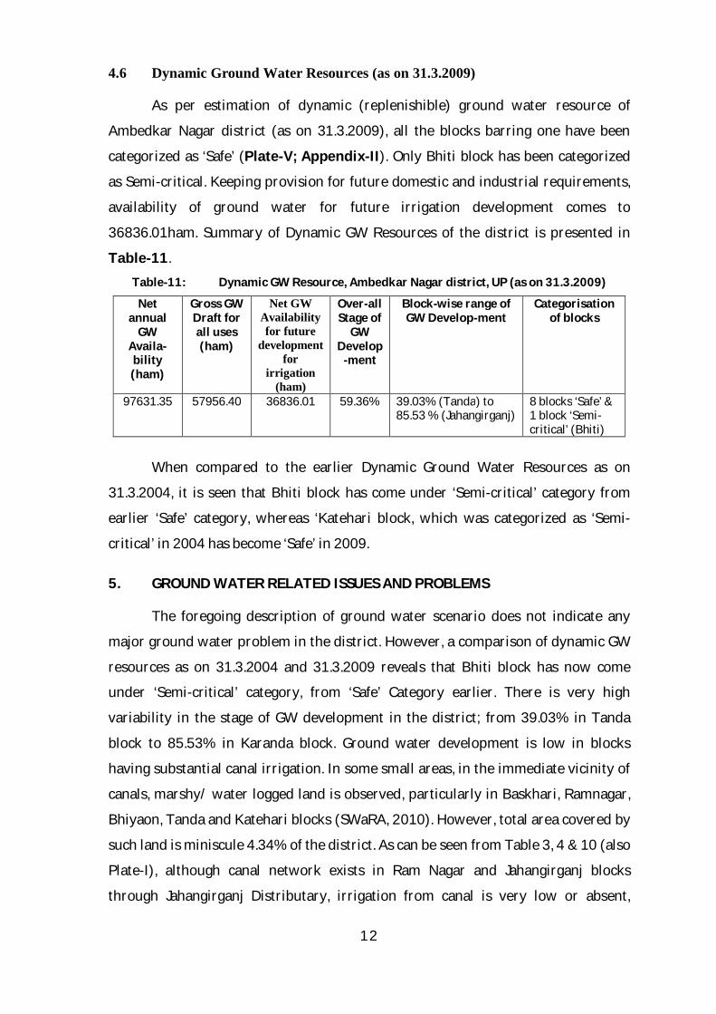
Table-11. Table-11: Dynamic GW Resource, Ambedkar Nagar district, UP (as on 31.3.2009)
Net annual
GW Availa-bility (ham)
Gross GW Draft for all uses (ham)
Net GW Availability for future
development for
irrigation (ham)
Over-all Stage of
GW Develop
-ment
Block-wise range of GW Develop-ment
Categorisation of blocks
97631.35 57956.40 36836.01 59.36% 39.03% (Tanda) to 85.53 % (Jahangirganj)
8 blocks ‘Safe’ & 1 block ‘Semi-critical’ (Bhiti)
When compared to the earlier Dynamic Ground Water Resources as on
31.3.2004, it is seen that Bhiti block has come under ‘Semi-critical’ category from
earlier ‘Safe’ category, whereas ‘Katehari block, which was categorized as ‘Semi-
critical’ in 2004 has become ‘Safe’ in 2009.
5. GROUND WATER RELATED ISSUES AND PROBLEMS
The foregoing description of ground water scenario does not indicate any
major ground water problem in the district. However, a comparison of dynamic GW
resources as on 31.3.2004 and 31.3.2009 reveals that Bhiti block has now come
under ‘Semi-critical’ category, from ‘Safe’ Category earlier. There is very high
variability in the stage of GW development in the district; from 39.03% in Tanda
block to 85.53% in Karanda block. Ground water development is low in blocks
having substantial canal irrigation. In some small areas, in the immediate vicinity of
canals, marshy/ water logged land is observed, particularly in Baskhari, Ramnagar,
Bhiyaon, Tanda and Katehari blocks (SWaRA, 2010). However, total area covered by
such land is miniscule 4.34% of the district. As can be seen from Table 3, 4 & 10 (also
Plate-I), although canal network exists in Ram Nagar and Jahangirganj blocks
through Jahangirganj Distributary, irrigation from canal is very low or absent,
13
indicating that sufficient water does not reach tail-ends of the canal. As a result stage
of GW development in these blocks is relatively high (77.5% % 85.53%
respectively). However, water levels in these blocks are between 2-5mbgl during
post-monsoon (Plate-IV) and there is no significant decline, suggesting that situation
is not alarming. Canal network is absent in the ‘Semi-critical’ Bhiti block.
6. GROUND WATER MANAGEMENT STRATEGY
The present level of ground water development is 59.36% in the district,
leaving net ground water availability for future irrigation development as
36836.01ham. Out of the 9 blocks, 8 have been categorized as ‘Safe’. Only Bhiti block
falls under ‘Semi-critical’ category. Thus, additional irrigation potential can be
judiciously exploited in all the ‘Safe’ blocks.
It also follows from the discussions in the preceding section (Section-5) that
establishing canal network in Bhiti block and ensuring availability of water at the
tail end, combined with practice of conjunctive use of surface and ground water is
the need of the hour in order to maintain the right balance between surface and
ground water and also to bring about parity in ground water development across
the district.
7. AWARENESS AND TRAINING ACTIVITY
No Mass Awareness Programme or Water Management Training Programme
has been organized by CGWB in Ambedkar Nagar district.
8. AREA NOTIFIED BY CGWA
No area/ block of Ambedkar Nagar district has been notified by CGWA.
9. RECOMMENDATIONS
Canal network should be established in Bhiti block, which has now come
under ‘Semi-critical’ category.
Availability of water at the tail end should be ensured, particularly in
Ramnagar and Jahangirganj blocks.
Practice of conjunctive use of surface and ground water is the need of the
hour in order to maintain the right balance between surface and ground
14
water and also to bring about parity in ground water development across the
district.
Deep exploratory drilling should be undertaken in the district to ascertain
characteristics of deeper aquifers.
BIBLIOGRAPHY/ REFERENCE
GSI, 2001: District Resource Map of Faizabad District; Geological Survey of India, NR Published Map.
Khan, E.A, Pandey, B.N. and Dwivedi, G.N., 1990: Quaternary Geological and Geomorphological Mapping in Parts of Ghaghra Basin, District Basti, Gonda and Faizabad, Uttar Pradesh (Progress Report for the F.S. 1987-88); GSI Unpub. Report.
Khnna, P.C., Bhartiya, S.P. and Bisaria, B.K., 1992: Quaternary Geology and Geomorphology of Sultanpur District and Adjoining Part of Faizabad, Jaunpur, Pratapgarh and Raebareli Districts, Uttar Pradesh (Progress Report for the F.S. 1985-86 & 1986-87); GSI Unpub. Report.
Pandey, D.S., 2012: Hydrogeology and Ground Water Potential of Ambedkar Nagar District; CGWB Unpub. Report.
Srivastava, N.K., 2003: Report on Ground Water Management Studies in Faizabad (Undivided) District (UP); CGWB Unpub. Report.
Singh, U.B., 2005: A Report on Reappraisal Hydrogeological Survey in Azamgarh District, (UP); CGWB Unpub. Report.
Arsenic Toxicity in Ground Water of Uttar Pradesh - Technical Report of SWaRA, Government of UP
SWaRA, 2010: Landuse/ Landcover Atlas, Ghaghra Gomti Basin (UP Water Sector Restructuring Project) by State Water Resource Agency (SWaRA).
District Sankhyiki Patrika available on website updes.up.nic.in (UP Directorate of Economics & Statistics)
District Industrial Profile of Ambedkar Nagar District, UP by MSME Development Institute, Allahabad, Ministry of Micro, Small & Medium Enterprise (MSME), Government of India (available on http://dcmsme.gov.in/dips/Ambedkar%20ngr%206-11.12.pdf)
NBSS & LUP, 2004: Soil Map of Uttar Pradesh published by National Bureau of Soil Survey & Land Use Planning (ICAR).
UP Jal Nigam website www.upjn.org
Census India web site www.censusindia.gov.in
15
16
17
18
19
20
APPENDIX-I
Summarized Hydrogeological Results of Exploratory Drilling by CGWB in (and near) Ambedkar Nagar District, UP
Sl. No.
LOCATION Block TYPE OF WELL
DEPTH DRILLED
(mbgl)
DEPTH CONS-
TRUCTED (mbgl)
AQUIFER ZONES TAPPED (mbgl)
STATIC WATER LEVEL (mbgl)
DIS-CHARGE
(lpm)
DRAWDOWN
(m)
SPECIFIC CAPACITY (lpm/m) of
DD
TRANSMI-SSIVITY, T (m2/day)
STORA-TIVITY, S
REMARKS
1 BIBIPUR BHUSAULI Jalalpur EW 305.41 229.00 38-50; 55-61; 118-148; 201-224;
4.29 2270 8.62 263 355 --- EC 580
2 PITHIA Jalalpur EW 304.80 220.00 36-54; 59-66; 94-100; 111-122; 134-168; 191-197; 203-215;
4.35 3050 3.05 1000 --- EC 603
3 BALAIPUR
*** EW 582.00 440.00 35-64; 212-220; 269-289; 324-334; 420-435
4.84 2150 14.15 152 473 EC 660
*** Azamgarh District
21
APPENDIX-II
Dynamic Ground Water Resources, Ambedkar Nagar District, UP (as on 31.03.2009)
Block Net Annual GW
availability (in ham)
Existing gross GW draft for Irrigation (in ham)
Existing gross GW draft for
Domestic & Industrial
Water Supply (in ham)
Existing gross GW draft for all
uses (in ham)
Provision for
domestic & industrial supply for
2025 (ham)
Net GW Availability for
future development for irrigation
(ham)
Stage of GW development
(in %)
Category
Akbarpur 19129.45 8899.7 823.81 9723.51 1335.56 8894.19 50.83 Safe
Baskhari 9084.79 4877.29 429.58 5306.87 631.65 3575.85 58.41 Safe
Bhiti 6571.32 4965.36 398.19 5363.55 657.59 948.37 81.62 Semi-critical
Bhiyaon 9365.69 4522.64 451.29 4973.93 699.97 4143.08 53.11 Safe
Jahangirganj 6802.45 5358.54 459.71 5818.25 679.49 764.42 85.53 Safe
Jalalpur 12399.41 6331.39 667.28 6998.67 1051.07 5016.95 56.44 Safe
Katehari 9188.27 6071.88 468.11 6539.99 734.88 2381.51 71.18 Safe
Ram Nagar 8926.68 6393.58 530.06 6923.64 900.65 1632.45 77.56 Safe
Tanda 16163.30 5711.34 596.65 6307.99 972.76 9479.20 39.03 Safe
Total District 97631.35 53131.72 4824.68 57956.40 7663.62 36836.01 59.36