Embed Size (px)
DESCRIPTION
Brazil is the world’s fourth biggest climate polluter. Deforestation and land-use change make up 75% of all Brazilian greenhouse gas emissions. From this, 59% comes from loss of forest cover and burning in the Amazon region.
Citation preview

AmAzon CAttle footprint
mAto Grosso: stAte of DestruCtion

2
AreAs under threAt
The Amazon Basin covers an area of approximately 6.5 million km2 across nine South American countries, five percent of the Earth’s surface. It holds the largest river system on the planet, about one-fifth of the total volume of fresh water of the world. Some 60% of the Amazon basin (4.1 million km²) is inside Brazil’s borders.1
Brazil’s Legal Amazon is an administrative designation and includes the whole Amazon forest2 in Brazil, plus some areas of savannah in the states of Mato Grosso and Tocantins. So far, 700 thousand km2 of the original Amazon forest cover of Brazil has been destroyed - this is equivalent to an area more than twice the size of Poland3.
LocaTIon of MaTo Grosso In ThE aMazon rEGIon
Table of ConTenTs
IntroductIon . . . . . . . . . . . . . . . . . . . . . . . . . . . . 3hoW Is AMAZon deForestAtIon MeAsured? . . . . . . . . . 4eXPAnsIon oF cAttLe rAnchInG In the LeGAL AMAZon . . . 5dIstrIButIon oF InFrAstructure . . . . . . . . . . . . . . . . 6the IMPAct oF the IndustrY . . . . . . . . . . . . . . . . . . . 7cAttLe FootPrInt In MAto Grosso . . . . . . . . . . . . . . . 8 cAttLe rAnchInG eXPAnsIon AreAs In the AMAZon BIoMe, MAto Grosso stAte . . . . . . . . . . . . . . . . 8 the FAr north (nortão) . . . . . . . . . . . . . . . . . . . . . . . . 8 AMAZon BIoMe strIP . . . . . . . . . . . . . . . . . . . . . . . . . . 8 the Br-163 – ALtA FLorestA roAd AXIs . . . . . . . . . . . . . . 9 the sPrInGs oF the XInGu rIver . . . . . . . . . . . . . . . . . . . 9ModIs IMAGe And LAnd use . . . . . . . . . . . . . . . . . . . . 10
threAtened herItAGe . . . . . . . . . . . . . . . . . . . . . . . . 11current LAnd use In the stAte oF MAto Grosso . . . . . . 12sMoKInG KILLs . . . . . . . . . . . . . . . . . . . . . . . . . . . . 13LAnd use MAP MethodoLoGY . . . . . . . . . . . . . . . . . . . 13reAsons to stoP destructIon oF the AMAZon rAInForest . . . . . . . . . . . . . . . . . . . . . . . . 14WhAt Must Be done . . . . . . . . . . . . . . . . . . . . . . . . . 14 the BrAZILIAn GovernMent Must . . . . . . . . . . . . . . . . . 14 IndustrIALIsed countrIes Must . . . . . . . . . . . . . . . . . . 14 IndustrY Must . . . . . . . . . . . . . . . . . . . . . . . . . . . . . . 15 BAnK And Investors . . . . . . . . . . . . . . . . . . . . . . . . . . 15 cItIZens cAn . . . . . . . . . . . . . . . . . . . . . . . . . . . . . . . 15reFerences . . . . . . . . . . . . . . . . . . . . . . . . . . . . . . 15
Amazon Biome boundary
Mato Grosso state boundary
Brazilian Legal Amazon
3AMAZon cAttLe FootPrInt
IntroductIon
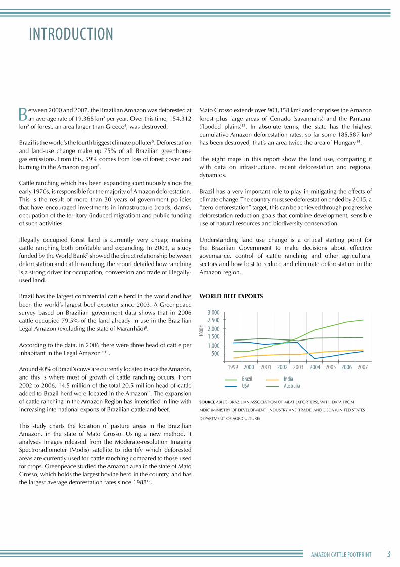
Between 2000 and 2007, the Brazilian Amazon was deforested at an average rate of 19,368 km² per year. Over this time, 154,312
km² of forest, an area larger than Greece4, was destroyed.
Brazil is the world’s the fourth biggest climate polluter5. Deforestation and land-use change make up 75% of all Brazilian greenhouse gas emissions. From this, 59% comes from loss of forest cover and burning in the Amazon region6.
Cattle ranching which has been expanding continuously since the early 1970s, is responsible for the majority of Amazon deforestation. This is the result of more than 30 years of government policies that have encouraged investments in infrastructure (roads, dams), occupation of the territory (induced migration) and public funding of such activities.
Illegally occupied forest land is currently very cheap; making cattle ranching both profitable and expanding. In 2003, a study funded by the World Bank7 showed the direct relationship between deforestation and cattle ranching, the report detailed how ranching is a strong driver for occupation, conversion and trade of illegally-used land.
Brazil has the largest commercial cattle herd in the world and has been the world’s largest beef exporter since 2003. A Greenpeace survey based on Brazilian government data shows that in 2006 cattle occupied 79.5% of the land already in use in the Brazilian Legal Amazon (excluding the state of Maranhão)8.
According to the data, in 2006 there were three head of cattle per inhabitant in the Legal Amazon9, 10.
Around 40% of Brazil’s cows are currently located inside the Amazon, and this is where most of growth of cattle ranching occurs. From 2002 to 2006, 14.5 million of the total 20.5 million head of cattle added to Brazil herd were located in the Amazon11. The expansion of cattle ranching in the Amazon Region has intensified in line with increasing international exports of Brazilian cattle and beef.
This study charts the location of pasture areas in the Brazilian Amazon, in the state of Mato Grosso. Using a new method, it analyses images released from the Moderate-resolution Imaging Spectroradiometer (Modis) satellite to identify which deforested areas are currently used for cattle ranching compared to those used for crops. Greenpeace studied the Amazon area in the state of Mato Grosso, which holds the largest bovine herd in the country, and has the largest average deforestation rates since 198812.
Mato Grosso extends over 903,358 km² and comprises the Amazon forest plus large areas of Cerrado (savannahs) and the Pantanal (flooded plains)13. In absolute terms, the state has the highest cumulative Amazon deforestation rates, so far some 185,587 km² has been destroyed, that’s an area twice the area of Hungary14.
The eight maps in this report show the land use, comparing it with data on infrastructure, recent deforestation and regional dynamics.
Brazil has a very important role to play in mitigating the effects of climate change. The country must see deforestation ended by 2015, a “zero-deforestation” target, this can be achieved through progressive deforestation reduction goals that combine development, sensible use of natural resources and biodiversity conservation.
Understanding land use change is a critical starting point for the Brazilian Government to make decisions about effective governance, control of cattle ranching and other agricultural sectors and how best to reduce and eliminate deforestation in the Amazon region.
WORLD BEEF EXPORTS
sourcE ABIeC (BrAzILIAn ASSOCIATIOn OF MeAT exPOrTerS), WITH DATA FrOM
MDIC (MInISTry OF DeveLOPMenT, InDUSTry AnD TrADe) AnD USDA (UnITeD STATeS
DePArTMenT OF AGrICULTUre)
3.0002.5002.0001.5001.000
500
1999 2000 2001 2002 2003 2004 2005 2006 2007
1000
t
BrazilUSA
IndiaAustralia

4
hoW Is AMAZon deForestAtIon MeAsured?
Since 1988, the Brazilian national Institute for Space research (InPe) has released annual estimates of deforestation rates
in the Legal Amazon. Since 2002, these estimates have been prepared through digital tracking of images, following the Amazon Deforestation estimate Program (PrODeS) methodology, and using images generated by the Landsat satellite.
In 2004, annual deforestation rates in the Amazon reached their second highest level ever, then dropped dramatically until 200715. PrODeS preliminary data show that 11,968 km2 of Amazon forest were destroyed between August 2007 and July 2008 – a rise of 3,8% compared to the previous year16.
rates of deforestation in the Amazon are affected by international commodity price fluctuations, particularly of meat and soya17. When the price of both products drops, deforestation rates reduce significantly in the following year.
It remains to be seen what implications of the 2008 global financial crisis will have be the region.
sourcE IMAzOn
60
50
40
30
20
10
july/1994 1995 1996 1997 1998 1999 2000 2001 2002 2003 2004 2005 2006
35,000
30,000
25,000
20,000
15,000
10,000
5,000
cattl
e (R$
)
defo
resta
tion a
rea (
km)
cattle soya
deforestation
2
DEFORESTATiOn ShOWn By PRODES
AnnUAL DEFORESTATiOn RATES COMPARED TO MEAT AnD SOyA PRiCES
South America
Brazil
Amazon Biome
Deforested area

5AMAZon cAttLe FootPrInt
eXPAnsIon oF cAttLe rAnchInG In the LeGAL AMAZon
The number of cattle bred in the Legal Amazon is growing fast: between 1990 and 2003, the bovine herd more than doubled,
from 26.6 million to 64 million head of cattle – 60% of the herd are in the states of Mato Grosso and Pará18.
This growth intensifies Amazon forest destruction, as complex ecosystems are gradually being replaced by new pasture areas. According to Brazilian Institute of Geography and Statistics (IBGe), between 1996 and 2006 the area of pastures in the Amazon region grew by approximately 10 million hectares – an area about the size of Iceland.
sourcE IMAzOn
AREA OCCUPiED By CATTLE RAnChing in ThE LEgAL AMAzOn (hECTARES)
sourcE IBGe: MArAnHãO exCLUDeD
0
10,000,000
20,000,000
30,000,000
40,000,000
50,000,000
55,439,553
23,424,117
1996 2006
1,000,001 - 2,000,000
400,001 - 1,000,000
200,001 - 400,000
50,001 - 200,000
0 - 50,000
Legal Amazon boudary
HEADS OF CATTLE PER MUNICIPALITY
EXPAnSiOn OF CATTLE RAnChing in ThE LEgAL AMAzOn BETWEEn 1996 AnD 2006
650
600
550
500
450
400
1988 89 90 91 92 93 94 95 96 97 98 99 2000 01 02 03 04
50
45
4035
30
2015
defo
resta
tion (
x 1.00
0 km
2)
cattl
e (x 1
.000.0
00)
cattle deforestation
25
5560
65700
10350
64,1665
ToTaL hErd and ToTaL dEforEsTaTIon
1996 2006

6
dIstrIButIon oF InFrAstructure
The building of new roads allows human occupation and further destruction of the Amazon rainforest. An InPe survey shows
that up to 87% of deforestation in the region occurred less than 25 km from the first settled areas, where occupation started around 1978 as a result of roads opening up19. These roads, which link the northern region to the rest of Brazil, were heavily funded by the federal government in the 1970s. Unofficial roads connect local sites and are not shown on the official charts prepared by the Brazilian government Infrastructure and Transportation Agency (DnIT) and by the IBGe20. The number of roads allows cattle ranching to occur even in remote areas - hundreds of kilometres away from slaughter facilities.
Amazon Biome
Water bodies
O�cial roads
Non o�cial roads
Municipality capitals
Slaughterhouses
sLauGhTErhousEs and roads In MaTo Grosso

7AMAZon cAttLe FootPrInt
the IMPAct oF the IndustrY
This map shows how there is a marked concentration of deforested areas and pastures in the areas around cattle slaughterhouses.
These extend, via a network of roads, for hundreds of kilometres. even those units located on the Cerrado Biome (savannahs) have an impact on large areas of the Amazon forest.
Degraded forest
Pasture
Agriculture
Sugar cane
Principal roads
Slaughterhouses
Land usE and sLauGhTErhousEs In MaTo Grosso
WhAt does sIF MeAn?Slaughterhouses must be registered at the Federal Inspection Service (SIF) to gain permission to export their products to other states or abroad. SIF-registered facilities are just a fraction of all existing slaughterhouses, but they usually belong to the group of companies with the biggest production capacity. Of the 71 slaughter facilities registered at the SIF and located in the Amazon region, 45 are in Mato Grosso21. In addition, there are local and state facilities, plus an unknown number of clandestine cattle slaughterhouses supplying local markets.

8
cAttLe FootPrInt In MAto Grosso This analysis of land use identifies four main areas of expansion and consolidation of cattle production in the Amazon forest of the state of Mato Grosso.
the FAr north (nortão)This area encircled by the municipalities of Juína, Juara, Apiacás and Colniza in the northwest of Mato Grosso is one of the newest parts of the Amazon to be deforested for cattle ranching. The area is linked by road to the West, east and South where cattle ranching is already established. Over the past three years occupation of the far north has accelerated, mainly around Colniza, a town already linked to the Southern region of the Amazonas state. In these border regions the growth of cattle ranching is strongly connected to destructive logging.
AMAZon BIoMe strIP
This area extends towards the savannah and forms a strip in the Southernmost part of the biome. These areas were deforested before 2000 and have massive infrastructure, including roads and cattle slaughter and storage facilities.
There is no remaining intact rainforest in this area, instead it is characterised by extensive and continuous pastures with low density of cattle per hectare. It is hard to believe that this area was, not so long ago, rainforest.
CATTLE RAnChing EXPAnSiOn AREAS in ThE AMAzOn BiOME, MATO gROSSO STATE

9AMAZon cAttLe FootPrInt
the ALtA FLorestA – Br-163 roAd IntersectIon
The area along the Br-163 road is one of the best known sites for soya farming expansion in Mato Grosso. The areas close to the road, opened in 1970, are already completely occupied, and until you reach the municipality of Sinop to the north, soya plantations are the main cause of deforestation. At Sinop, and particularly at the intersection of the Br-163 with Alta Floresta, cattle ranching is dominant. recent deforestation for cattle ranching expands to the north up to the Pará state border, and to the West.
the sPrInGs oF the XInGu rIver
Most of the course of the xingu river in Mato Grosso is protected by the xingu Indigenous national Park, which covers 2,642,003 hectares22. Outside of the park, however, forest destruction threatens the springs of the river and therefore the course of water to it. This disrupts its delicate ecosystems needed to maintain biodiversity and support the almost 6,000 indigenous people from 14 different ethnic groups. In these areas it is possible to see recently deforested areas occupied by both cattle ranching and soya crops.
Sugar cane
Agriculture
Pasture
Principal roads
Amazon Biome
Water bodies
Municipality capitals
State capital
Expansion areas
Degraded forest
Indigenous lands
Conservation areas
CATTLE RAnChing EXPAnSiOn AREAS in ThE AMAzOn BiOME, MATO gROSSO STATE

10
ModIs IMAGe And LAnd use
LAnD USE in LEgAL AMAzOn in 2006 LAnD USE in LEgAL AMAzOn AnD in BRAziL in 2006
PASTURE
aGrIcuLTurE
0
10,000,000
20,000,000
30,000,000
40,000,000
50,000,000
55,439,553
23,424,117
1996 20060
10,000,000
20,000,000
30,000,000
40,000,000
50,000,000
55,439,553
23,424,117
1996 2006
AGrIcuLture
20,5%
PAsture
79,5%
0
10,000,000
20,000,000
30,000,000
40,000,000
50,000,000
55,439,553
23,424,117
1996 2006
LeGAL AMAZon
55,439,553 hAtotAL oF PAsture In BrAZIL
172,333,073 hA
totAL oF AGrIcuLture In BrAZIL76,697,324 hA
LeGAL AMAZon
14,272,549 hA
Land usE on saTELLITE IMaGE
sourcE IBGe
Pasture
Amazon Biome boundary
Agriculture
Principal roads
Degraded forest

11AMAZon cAttLe FootPrInt
threAtened herItAGe
The Amazon basin holds the largest tropical forest in the world and it is the most diverse ecosystem on earth23,24. It plays a vital
role in ensuring the region’s water supplies, regulating rainfall, and it is crucial to keeping the world’s climate in balance. Two of the main tributaries of the Amazon river have their origins in Mato Grosso: xingu and Tapajós.
Deciduous seasonal forests
Mountain grass-woody
Savannah vegetation & Ecotones
Pioneer formations
Ecotone evergreen & semi-evergreen forests
Lowland evergreen broadleaf rainforest
Amazon Biome boundary
Semi-desciduous seasonal forests
orIGInaL VEGETaTIon In ThE sTaTE of MaTo Grosso
Deciduous seasonal forests
Mountain grass-woody
Savannah vegetation & Ecotones
Pioneer formations
Ecotone evergreen & semi-evergreen forests
Lowland evergreen broadleaf rainforest
Amazon Biome boundary
Semi-desciduous seasonal forestsDeciduous seasonal forests
Mountain grass-woody
Savannah vegetation & Ecotones
Pioneer formations
Ecotone evergreen & semi-evergreen forests
Lowland evergreen broadleaf rainforest
Amazon Biome boundary
Semi-desciduous seasonal forests

12
current LAnd use In the stAte oF MAto Grosso
Cattle ranching has been expanding and fuelling deforestation in the Amazon Biome of Mato Grosso state, but land use
distribution in Mato Grosso also includes vast areas of savannah, where industrial farming of monocultures, particularly soya crops, impact four prominent areas.
The Lucas do rio verde region is the biggest agriculture area in • Mato Grosso and it extends beyond the savannah, occupying large areas of the Amazon forest.
The Chapada dos Parecis region, between the land strip and the • remaining Amazon Biome, has expanded along the Porto velho – Santarém export axis, which follows the Amazon river.
Soya crops (which require intensive use of agrochemicals), • as well as cattle, also threaten the xingu river springs and occupy mainly the neighbouring area on the Southeast of the indigenous park.
Large areas of Cerrado (savannah) in Southeast of Mato Grosso • given place to extensive soya plantations in the last 20 years.
Agriculture
Degraded forest
Pasture
Sugar cane
Municipality capitals
State capital
Land usE In ThE sTaTE of MaTo Grosso
Xingu’s indigenous park
Chapada dos parecis
lucas do rio Verde

sMoKInG KILLsAugust 2008 cattle and pastures are rapidly replacing the Amazon rainforest. When the forest is converted to pasture, biodiversity goes up in smoke, and masses of co2 is released into the atmosphere.
LAnd use MAP MethodoLoGY
This study used images from the sensor Modis (Moderate resolution Imaging Spectroradiometer) covering a whole year period, selected every 16 days (a total of 23 for each area, for the whole year). With this, it was possible to create an overview of vegetation in the whole state of Mato Grosso, over a whole year.
The identification of the land activity in each image was done using two methods. First, images were separated according to their EVI (Enhanced Vegetation Index), which compares different levels of photosynthetic activity and concentration of vegetation. This method identifies agricultural activity as well as regenerated forest in areas where deforestation has been previously detected (by PrODeS).
To identify pastures, altered forest landscapes (victim of predatory logging) and degraded or secondary forest (capoeira) it was necessary to analyse each of the series of images visually. In the end, to evaluate the method, flights were carried out at the Eastern side of the Xingu Indigenous Park, in Sinop region around the Br-163, and north of Alta Floresta.
The Modis images are generated every day, so it is possible to follow changes to the vegetation throughout the year. However, the resolution of the images is very low - only accurate to 250m, or approximately an area of 6,25 ha. The constant presence of clouds in certain areas can make monitoring impossible in some regions.

14
reAsons to stoP destructIon oF the AMAZon rAInForest Forests are a crucial carbon stock: forest ecosystems globally store about one-and-• a-half times as much carbon as is present in the atmosphere.25 Deforestation of tropical forests is responsible for up to approximately 20% of the global emissions of greenhouse gas, more than the world’s entire transport sector.26
The Amazon is estimated to store between 80-120 billion tonnes of carbon.• 27,28 If this is destroyed, roughly 50 times the annual greenhouse gas emissions from the US will be emitted29.
Cattle ranching in the Amazon has horrific social impacts, including the highest • rates of slave labour in Brazil. 3005 rural workers, kept in slavery, were freed from cattle ranches in 2008. 99% of them had been held in the Legal Amazon30.
The region is home to more than 20 million people – including over 200,000 • indigenous people, belonging to 180 different ethnic groups31. The rainforest is their home, providing them food and shelter to tools and medicines - it is also central to their spiritual life.
Studies estimate that the Amazon supports 40,000 plant species; 427 mammals; • 1,294 birds; 378 reptiles; 427 amphibians and 3,000 species of fish32. Many other species are still unknown.
The Amazon produces 20% of river water in the world• 33. The forest influences the hydrologic cycle at local and regional scales, as humidity retained by the Amazon is carried by the wind to other parts of Brazil and South America. The reduction of the forest cover diminishes the amount of rainfall on the Southeast and Center of Brazil, affecting agriculture productivity34.
Belched methane from livestock constitutes one of the largest sources (roughly • 30%) of greenhouse gas emissions from agriculture. Agriculture as a whole contributes between 10-12% of global greenhouse gas emissions35.
The greenhouse gas emissions from beef are13 kilograms CO• 2-eq per kg36. This means eating a kilogram of beef represents roughly the same greenhouse emissions as flying 100 kilometers of a flight, per passenger. This is twice the carbon footprint of eating pigs or poultry37.
WhAt Must Be donethe BrAZILIAn GovernMent Must
Adopt ambitious deforestation reduction • targets in order to achieve zero deforestation in the Brazilian Amazon by 2015. Adopt a five-year moratorium immediately on deforestation as an intermediate step towards zero deforestation.
Support a strong climate protocol to be • tabled in Copenhagen, December 2009, that includes an international fund to reduce emissions from Deforestation and Degradation (reDD) that adheres to key principles integral for a credible financial mechanism to protect forests (such as those detailed in Greenpeace’s Forest for Climate proposal):
Provide sufficient annual funding to • tackle tropical deforestation and make it available immediately;
Is accessible to all countries with tropical • forests, including countries with low deforestation rates;
Protect biodiversity values and the rights • and livelihoods of indigenous peoples;
Protect against ‘leakage’ via national-• level accounting and reduction approaches in deforestation;
Does not directly include forest offset • credits in carbon markets;
Does not support the replacement of • natural forests with plantations and must not subsidise the expansion of industrial logging, agri-business and other destructive practices into forests.
enact and enforce the currently provisional act • in the Forest Code, which stipulates that no more than 20% of any private land holding in the Amazon can be legally cleared. This would avoid additional legal deforestation permits.
redirect investments that drive deforestation • into diversified economies including investing in people that support the sustainable use of forest products.
Increase investments to strengthen the • monitoring and control systems to fight forest crimes in the Amazon to ensure effective governance and law enforcement in the region.

15AMAZon cAttLe FootPrInt
reFerences
1 IBGe (2004) . IBGe lança o Mapa de Biomas do Brasil e o Mapa de vegetação do Brasil, emcomemoração ao dia Mundial da Biodiversidade . Available at: www .ibge .gov .br/home/presidencia/noticias/noticia_visualiza .php?id_noticia=169 . Accessed on: nov 26th 2008 .2 In this report, the Amazon ‘forest’ refers to the entire biome – the plants and animals that makeup this ancient ecosystem .3 Greenpeace (2008) Analysis on InPe (Brazilian national Institute of space research) Yearly estimative from 1988 until 2007, Annual deforestation rate (km2/year) Available at: http://www .obt .inpe .br/prodes/prodes_1988_2007 .htm . Accessed on: nov 26th 2008 .4 Ibid 3 .5 World resources Institute (2007) climate Analysis Indicators tool (cAIt) version 4 .0 .6 Brazilian Ministry of science and technology – Mct (2006) Primeiro Inventário Brasileiro de emissões Antrópicas de Gases de efeito estufa .7 Margulis, s . Causas do Desmatamento da Amazônia Brasileira . 1st editon . Brasília: Banco Mundial, 2003 . 100p .8 Greenpeace analysis based on IBGe data . Available at: http://www .ibge .gov .br/home/estatistica/economia/agropecuaria/censoagro/2006/default .shtm . Accessed on: oct 29th 2008 .9 IBGe (2006) . censo Agropecuário 2006 . Available at: http://www .ibge .gov .br/home/estatistica/economia/agropecuaria/censoagro/2006/default .shtm . Accessed on: oct 29th 2008 .10 IBGe (2007) . contagem da População 2007 . Available at: http://www .ibge .gov .br/home/estatistica/populacao/contagem2007/default .shtm . Accessed on: oct 29th 2008 .11 Ibid 9 .12 Ibid 6 .13 IBGe . estados . Available at: http://www .ibge .gov .br/estadosat/perfil .php?sigla=mt . Accessed on:oct 29th 2008 .14 Ibid 3 .15 Brazilian national Institute of space research (InPe) . Available at: http://www .obt .inpe .br/deter .Accessed on: nov 4th 2008 .16 Brazilian national Institute of space research (InPe) . Available at: http://www .obt .inpe .br/prodes/prodes_1988_2008 .htm . Accessed on: dec 16th 2008 .17 Barreto, P . (2007) . Porque o desmatamento cai e desce? In: 5º seminário técnico-científico deAnálise de dados referentes ao desmatamento . MMA/InPe . IMAZon, Anápolis . 38p .18 Barreto, P .; et al . Pecuária e Desafios para a Conservação Ambiental na Amazônia. o estado daAmazônia, n .5, p . 1-4,2005 .19 Alves, d . o . Processo de desmatamento na Amazônia. Parcerias estratégicas, n .12, p .259-275, 2001 .20 Brandão Jr ., A . o . et al . Desmatamento e estradas não-oficiais da Amazônia, In: sIMPÓsIo BrAsILeIro de sensorIAMento reMoto, 13, 2007, Florianópolis . Anais . . . InPe, p .2357-2364, 2007 .21 Ministério da Agricultura, Pecuária e Abastecimento – MAPA (2008) . Available at: www .agricultura .gov .br . Accessed on: oct 29th 2008 .22 secretaria de estado de Planejamento e coordenação Geral . Anuário estatístico de Mato Grosso (2004) . cuiabá: sePLAn-Mt . central de texto, 2005 . vol .26 . 718p .23 Ibid 1 .24 Brazilian Ministry of environment (MMA) . Brazilian Biodiversity . In: MMA, First national report for the convention on biological diversity – BRAZIL, 1998, 10p . Available at: www .cbd .int/doc/world/br/br-nr-01-p1-en .pdf . Acessed on: 26th nov . 2008 .25 Watson, r . t . , et al . Land use, land-use change, and forestry: special report of theIntergovernmental Panel on climate change . cambridge, uK: cambridge university Press, 2000 . 375p .26 IPcc, Working Group III: Climate Change 2007: Mitigation. Contribution of Working Group III to the Fourth Assessment Report of the Intergovernmental Panel on Climate Change (2007) B . Metz, o .r . davidson, P .r . Bosch, r . dave, L .A . Meyer (eds), cambridge university Press, cambridge, united Kingdom and new York, nY, usA .27 saatchi, s .s ., et al . distribution of aboveground live biomass in the Amazon Basin . Global Change Biology, 13: 816-837 .28 Malhi, Y ., et al . 2008 . climate change, deforestation, and the Fate of the Amazon . Science, 319: 169-172 .29 World resources Institute (2008) climate Analysis Indicators tool (cAIt) version 6 .0 .30 repórter Brasil (2008) . Lista suja do trabalho escravo . Available at: http://www .reporterbrasil .org .br/listasuja/index .php?lingua=en . Acessed on: nov 03rd 2008 .31 coordenação das organizações Indígenas da Amazônia Brasileira – coIAB (2006), história .32 rylands, A . B ., et al . Amazonia . In: Mittermeier;, r . A ., et al . (eds .) Wilderness: earth’s last wild places . Mexico city: ceMeX, 2002 . p . 57-107 .33 Mittermeier, r .A ., et al . Wilderness: earth’s Last Wild Places . 1st edition . Washington d .c ., usA: conservation International, 2002 . 576p .34 Brazilian national Institute of space research (InPe), Monitoramento da Cobertura Florestal da Amazônia por Satélites, são José dos campos: InPe, 2008 . 148p .35 Bellarby, J ., et al . Cool Farming: climate impacts of agriculture and mitigation potential . 2008 . 44p . Available at: http://www .greenpeace .org/raw/content/international/press/reports/cool-farming-full-report .pdf . Acessed on: 26th nov . 2008 .36 WrI (World resources Institute) & WBcsd (World Business council for sustainable development) . Greenhouse Gas Protocol Initiative (GhG Protocol) . Available at: www .ghgprotocol .org . Accessed on: nov 26th 2008 .37 Ibid 35 .
IndustrIALIsed countrIes Must
Agree a strong climate protocol in • Copenhagen that includes an international fund to stop deforestation governed by the key principles detailed above.
ensure that reducing emissions from deforestation and • degradation is additional to industrialised nations’ actions to reduce their own emissions.
IndustrY MustSupport the call for zero Deforestation in the Brazilian • Amazon.
Stop the trade in products from deforestation and communicate • to suppliers that they will no longer buy from companies engaged in deforestation.
Provide reliable guarantees of the origin of cattle products such • as meat and leather to customers.
reduce their own greenhouse gas emissions by adopting • environmentally-friendly methods of production, absolute emissions reductions in line with the scale of global cuts needed and establish renewable energy targets.
Publically call on governments and international community to • support a strong climate protocol in 2009, including a credible reDD funding mechanism based on the principles outlined above.
BAnK And InvestorsStop financing companies involved in deforestation in the • Amazon Biome.
cItIZens cAnJoin Greenpeace in the call for zero deforestation in the Amazon • rainforest by 2015, by supporting appeals to the Brazilian government, their national government and international community to support this demand.
Join Greenpeace’s call to governments and companies take real • action to halt deforestation and save the climate. In particular to pressure governments to agree a strong climate deal in Copenhagen in December 2009.
Take individual action to reduce their carbon footprint. Some • ways of doing so include reducing the quantity of meat consumed, and checking the origin of the meat or soya products they buy.

Greenpeace is an independent global campaigning organisation that acts to change attitudes and behaviour, to protect and conserve the environment and to promote peace.
Published by Greenpeace Brazil
Photos Greenpeace/Daniel Beltrá
Maps Amazon Greenpeace Maps
Design Gabi Juns (gabrielajuns.com.br)
Greenpeace Brazil
São Paulo
Rua Alvarenga, 2.331
Butantã - 05509-006
São Paulo - SP - Brazil
Tel +55 11 3035-1155
Fax +55 11 3817-4600
ManauS
Av. Joaquim Nabuco, 2367
Centro - 69020-031
Manaus - AM - Brazil
Tel +55 92 4009-8000
Fax +55 92 4009-8004
Printed on 100% recycled post-consumer
waste with vegetable based inks.
© G
reen
peac
e/Al
berto
césa
r Ara
újo