Embed Size (px)
Citation preview
ALPHA COLLEGE OF ENGINEERING
DEPARTMENT OF CIVIL ENGINEERING
QUESTION BANK
10CV34 – SURVEYING-I
UNIT -01
INTRODUCTION
1. Explain plane surveying and geodetic surveying.
2. Write a note on precision and accuracy in surveying.
3. What are the uses of surveying in Civil Engineering?
4. Give the classification of survey based on the equipment’s that is being used.
5. Explain the following
a) Topographical maps and their numbering b) Principle of working from whole to part
6. What are the basic principles of surveying? Explain with sketches.
7. Distinguish between a) Plane surveying and Geodetic surveying b) Plan and Map c) Accuracy
and Precision
8. Discuss in brief the different sources of error in chain survey
9. Sketch the map conventional signs for the following a) Temple b) Railway double line c) Lake
d) Buildings
10. Write a note on well-conditioned triangle.
11. Mention the objectives of surveying.
12. Briefly explain about the classification of maps based on scale.
13. How surveying is defined? Name the two basic principles of surveying.
14. Give the fundamental difference between plane surveying and geodetic surveying.
15. What is meant by reconnaissance survey?
16. Explain the observations made in an index sketch.
17. What do you understand by (i) scale (ii) drawing to scale.
18. Explain principal of Surveying.
19. With a simple sketch state the construction and use of a cross staff
20. Explain the principal of working from whole to part
21. What is a well-conditioned triangle? Examine whether a triangle having sides 80m, 60m and
40m is well conditioned or not
UNIT -02
MEASUREMENT OF HORIZONTAL DISTANCES
1. What is the principle of chain surveying?
2. What is meant by well-conditioned triangle?
3. Distinguish between survey station and tie station.
4. What are the instruments used for a chain surveying
5. Distinguish between Metric chain an Engineer's chains.
6. How do you test a chain?
7. What are the instruments used for a chain surveying
8. What are the instruments used for setting out right angles to a chain One?
9. What is Representative fraction?
10. How do you record the field observation in a field book?
11. What is meant by hypotenusal allowance?
12. What are the different Sources of errors in chain surveying?
13. What are the different tape corrections?
14. Explain the Graphical method of enlarging a map.
15. What is ranging? What are the methods of ranging a survey line?
16. Explain the method of reciprocal ranging.
17. Explain with a neat sketch reciprocal ranging.
18. Explain briefly the principle of electromagnetic distance measurement.
19. Explain the principle of chain surveying. Under what circumstances the chain surveying is
more suitable?
20. Briefly explain the different tape corrections with equations.
21. What is ranging? Explain with a sketch the method of ranging a chain line with a line ranger.
22. Describe the method of ranging between two points which are not inter visible.
23. List the various corrections applied to tape and briefly explain them.
24. Explain the following a) Hypotenusal allowance b) Principle of Optical Square c) Principle
of Prism Square
25. List the formula used to apply correction for temperature, pull and sag. Explain the terms
along with their SI units.
26. Explain the types of chains.
27. What do you understand by indirect ranging? Explain a method in detail.
28. Explain the stepping method of chaining along a sloping ground.
29. Distinguish between direct and indirect ranging.
30. The distance between two points measured along a slope is 428m. Find the horizontal
distance between them if. a. The angle of slope between the points is 8 °. b. The difference in
level in 60 m. c. The slope is 1 in 4
31. A survey line PQ is run along different slopes as detailed below: a. P to R, upward slope of l
in 10, measured distance = 200m b. R to S, fall =25m, measured distance =227m c. S to Q
elevation 6 °, measured distance =232m Calculate the horizontal distance from P to Q
32. In a Chain survey distance between two points A & B was measured along the length as
500m. Find the horizontal distance between them in the following hypothical cases. i) The angle
of slope between the points A&B is 10 °. ii) The difference in level between A&B is 50m iii)
The slope is l in 5.
33. If the length of 250m is measured as a slope of line 4, find the horizontal length.
34. The distance between the points measured along a slope is 800m, find the distance between
the points if. i) The angle of slope between the points is 10 ° ii) The difference in level between
the points is 60m.
35. A 30m chain was found to be 0.20m too long after chaining 1525m.the same chain was found
to be 0.3m too long after chaining a total distance of 3050m. Find the correct length of total
distance chained assuming that the chain was correct at the commencement of chaining.
36. Calculate the sag correction for a 30m steel tape under a pull of 100 N in three equal spans of
10m each weight of cubic cm of steel is 0.078N. Area of cross – section of tape is 0.08cm 2.
37. A 30m tape weights 0.12N/m has a cross – sectional area of 0.020cm 2. It measures correctly
when supported throughout under a tension of 85N and at a temperature of 20 °C. When used in
the field the tape is only supported at its ends under a tension of 85N. The temperature is 13.5
°C. What is the distance between zero and 30m mark under these conditions.∝ =1.15*10 -5/°C.
38. The length of a chain line measured with a 20m chain was 1341m. The same line was found
to be 1350m long when measured with 30m, chain 20cm too short. What was the error in 20m
chains?
39. A tape 20 long of standard length at 84 °F was used to measure a line. The mean temperature
during measurement being 63 °F. The measured distance was 821.40m. The following being the
slopes; 2 ° 15 O for 100m, 4 ° 18 O for 125m, 1 °20 O for 50m, 7 °18 O for 200m, 3 °10 O for
250m and 5 °0O for 96.4m. Find the true length of the line if the co- efficient of expression is
62*10 -7/°F
40. To measure a base line. A steel tape 30m long standardized at 15 °C with a pull of 100N was
used. Find the correction per tape length if the temperature at the time of measurement was 20 °C
and the pull exacted was 160N. Weight of 1cm ³of steel=0.0786N, weight of tape=8N, E=2.1*10
7 N/mm², ∝= 7.1*10 -7/°C.
41. A steel tape of 30m long was standardized at a temperature of 20 °C at a pull of 65N. Find
the correction per tape length if the temperature and pull at the time of measurement are 25 ° C
and 100N. Weight of 1cubic cm of steel = 0.078N c/s area of tape = 0.08sq.cm. Modulus of
elasticity of Steel = 2.1*10 5 N/mm2. Coefficient of thermal expansion =1.16*10 -5/°C.
42. A 20m chain was found to be 10cm too long after chaining a distance of 1500m. It was found
to be 18cm too long at the end of days’ work after chaining a total distance of 2900m. Find the
true distance if the chain was correct before the commencement of the work.
43. What is the correct length of a line which is measured as 350m with a 20m tape, 10cm too
long?
44. The distance between two stations was measured with a 20m chain and found to be 1500m.
The same was measured with a 30m chain and found to be 1476m. If the 20m chain was 5cm too
short, what was the error in the 30 chain?
45. A steel tape 30m long standardized at 20 °C with a pull of 100N was used to measure a base
line. Find the correction per tape length if the temperature at the time of measurement was 22 °C
and the pull exerted was 150N. Weight of steel per meter cube =77.5kN weight of tape = 6.8N,
E=2.11*10 5N/mm 2 ∝=12*10 -6/°c.
46. A steel tape of normal length 30m was used to measure a line AB by suspending it between
support .If the measured length was 29. 64 m, when the slope angle was 4 °30 O and the mean
temperature and tension applied were 10 °C and 100N respectively. Determine the corrected
horizontal length of AB.
47. The standard length of the tape was 30m at 20 °C and the standard pull was 45N tension. The
tape weighed 0.16N/m and had a cross – sectional area of 2mm 2, E=2*10 5N/mm 2and α=
1.12*10 -5/°C.
48. Calculate the sag correction for a 50m steel tape under a pall of 120N in five equal spans of
10m each. Weight of one cubic cm steel = 0.078N. Area of cross section of tape = 0.09sq .cm
49. A line was measured by a 20m chain, which was accurate before starting the day work. After
chaining 900m,the chain was found to be 6cm too long. After chaining a total distance of 1575m
the chain was found to be 14cm too long. Find the distance of the line.
50. A rectangular land of 315m*750m is required to be established. A 30m chain was calibrated
and found to measure 30mm too long. What measurement must be laid on the ground?
51. An old map was dream to scale of km = 10cm. The field was surveyed with a 30m chain,
which was actually 5cm too long. An original length of 10cm has now shrunk to 9.75cm on the
plan. The plan area measured with a plainimeter is 97.03cm 2 calculate the actual area of land in
hectares.
52. At the end of the survey of land a tape of 30m length was found to be 10cm short. The area
of the plan drawn with measurement taken with the tape is found to be 135cm 2. If the scale of
the plane is 1/1006, what is the true area of the field, assuming that the chain was expect 30m at
commencement of the survey.
53. A rectangular field was surveyed with a 30m chain the length and breadth of the field were
found to be 3000m and 2500m respectively. In the beginning the chain was 5cm too short and at
the end of the work it was 3cm too long. What is the actual area of the filed?
54. The area of an old plan, plotted to a scale of 1cm to 10m measure snow 100.2cm 2. The plan
has shrunk so that a line originally 10cm long now measure 9.7cm. There was a note on the plan
that the 20m chain used was 8cm too short. Find the true area of the plot.
UNIT -03
CHAIN SURVEYING
1. Explain with a neat sketch the principle, working, construction and use of optical square
2. Explain a method of overcoming an obstacle in chain surveying when both vision & chaining
are obstructed
3. Explain briefly the different methods of setting out right angles by using instruments. Draw
the line diagram.
4. List out the various obstacles that are encountered in chaining and explain any one of them.
5. List the accessories required for a typical chain survey work
6. Explain any four methods for determining the width of river.
7. How would you overcome the chaining problem if there were obstacles on the chain line?
Assuming that the chaining rounded the obstacle is possible.
8. Discuss briefly “Recording Field Notes” in chain surveying
9. Explain the following a) Base line b) Check line c) Tie line d) Random line
10. Name the different types of cross-staffs used for setting out offsets to chain line. Explain the
construction and working off anyone.
11. Describe a method of determining the width of a river using a) Chain only b) Chain and
optical square
12. What are the precautions that should be taken to minimize the errors in chain survey work?
13. Explain the method of overcoming chaining problem if a) The obstruction is in the form of a
pond b) The obstruction is in the form of a river
14. With a neat sketch explain any one method of overcoming an obstacle to both ranging and
chaining.
15. Two Stations P&Q on the main survey line were taken on the opposite sides of a pond. On
the right of PQ, a line PR, 210 m long was laid down and another line PS, 260m long was laid
down on the left of PQ. The points R, Q, and S are on the same straight line. The measured
lengths of RQ and QS are 85m and 75m respectively. Compute the length of PQ.
16. AB is a line crossing a lake, A and B are on opposite sides of the lake. Another line AC=800
m long is ranged to the right of AB clear of the lake. Similarly another line AD = 1000m is
ranged to the left of AB such that the points C, B and D are collinear. The lengths BC and BD
are 400m and 600m respectively. If the chainage of A is 1262.44m. Calculate the chainage of B.
17. While running a survey line AB, it was found that a building obstructs it. To overcome the
problem of the obstruction, a perpendicular BC, 143.65m long, was erected at B from C two
lines CD & CE were set out at angles 30 ° and 50 °, respectively, from CB. Determine the length
of BD and BE, if D and E are on the prolongation of AB. Also determine the lengths of CD and
CE.
18. A chain line PQ intersects a pond. Two points A & B are taken on the chain line on opposite
sides of the pond. A line AC, 250m long, is set but on the left of AB and another line AD, 300m
long is set out on the right of AB. The points C, B and D are in the same straight line. CB and
BD are 100m and 150m long respectively. Calculate the length of AB.
19. While crossing a pond, stations A and D were taken on opposite sides of the pond. Lines AB
of 250m and AC of 200m were ranged on either side of pond such that points B, C and D are
along a straight alignment. Distances BD and DC were measured as 100m and 125m
respectively. Compute the obstructed length AD.
20. A chain line ABC crosses a river, B and C being on the near and distant banks respectively.
The respective bearings of C and A taken at D, a point 60m measured at right angles at AB from
B are 280 ° and 190 °. AB being 32m. Find the width of the river.
21. A chain line ABC crosses a river, the points B & C are on the near and distant banks
respectively. A line BD of 50m lengths is setout at right angles to the chain line at B. If the angle
BDC is 60 °, find the width of the river.
22. A cross staff survey was conducted along the chainage of 1000m as follows.
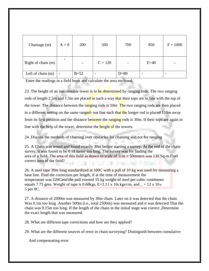
Chainage (m) A = 0
200
500 700 850 F = 1000
Right of chain (m) -
- C = 120 - E=40 -
Left of chain (m) - B=52 - D=80 - -
Enter the readings in a field book and calculate the area enclosed.
23. The height of an inaccessible tower is to be determined by ranging rods. The two ranging
rods of length 2.5m and 1.5m are placed in such a way that their tops are in line with the top of
the tower. The distance between the ranging rods is 10m The two ranging rods are then placed
in a different setting on the same ranged- out line such that the longer rod is placed 110m away
from its first position and the distance between the ranging rods is 30m. If their tops are again in
line with the help of the tower, determine the height of the towers.
24. Discuss the methods of chaining over obstacles for chaining and not for ranging
25. A Chain was tested and found exactly 30m before starting a survey. At the end of the chain
survey, it was found to be 0.18 meter too long. The survey was for finding the
area of a field. The area of this field as drawn to scale of 1cm = 50meters was 130 Sq-m.Find
correct area of the field?
26. A steel tape 30m long standardized at 100C with a pull of 10 kg was used for measuring a
base line. Find the correction per length, if at the time of measurement the
temperature was 220Cand the pull exerted 15 kg weight of steel per cubic centimeter
equals 7.75 gms. Weight of tape is 0.68kgs, E=2.11 x 10⁶ kgs/cm, and _ = 12 x 10-6
5 per 0C.
27. A distance of 2000m was measured by 30m chain. Later on it was detected that the chain
Was 0.1m too long .Another 500m (i.e., total 2500m) was measured and it was detected.That the
chain was 0.15m too long. If the length of the chain in the initial stage was correct ,Determine
the exact length that was measured.
28. What are different tape corrections and how are they applied?
29. What are the different sources of error in chain surveying? Distinguish between cumulative
And compensating error
UNIT -04
COMPASS SURVEYING
1. Distinguish between a. WCB and RB system b. Dip and declination c. Magnetic bearing and
true bearing d. Triangulation survey and traverse survey. e. Fore bearing and back bearing f.
Prismatic compass and surveyors compass g. Open and closed traverse
2. Compare between prismatic compass and surveyors compass with neat sketch.
3. What are the sources of errors in compass surveying? List the precautions to be taken to
eliminate them.
4. Explain the common systems of designating bearings.
5. Explain the method for determining the width of a pond by compass survey. 6. Determine the
values of included angles in the closed compass traverse ABCD conducted in clockwise
direction, given the following.
LINEFORE BEARING
AB 40 °
BC 70 °
CD 210 °
DA 280 °Apply the check
6. In a closed traverse, the following bearings were observed with a compass. Calculate their
interior angles. Apply the check. Represent the answer on a neat sketch along with bearing.
LINE FORE BEARING
AB 60 ° 30 '
BC 122 ° 0’
CD 46 ° 0’
DE 205 ° 30’
EA 300 ° 0’
7. The following interior angles were measured with a sextant in a closed traverse. The bearing
of the line AB was measured as 60 °00 O with prismatic compass. Calculate the bearings of all
other lines if ∠A=140 °10’, ∠B=90 °8’, ∠C=60 °22’, ∠D=69 °20’.
8. The following angles were observed in clockwise direction in an open traverse ∠ABC=124
°15’, ∠BCD=156 °30’, ∠CDE=102 °, ∠DEF=95 °15’, ∠EFG=215 °45’. The magnetic bearing of
the line AB was 241 °30’. Calculate the bearings of other line.
9. The magnetic bearing of a line PQ is 62 °30’. Calculate the true bearing of PQ if the magnetic
declination is a) 3 °45’ W b) 4 °10’E.
10. In an anticlockwise traverse ABCDEA, the bearing of the line AB was measured as 150°30’.
The inclined angles are ∠A=130 °10’, ∠B=89 °45’, ∠C=125 °22’, ∠D=135 °34’ and ∠E=59
°09’. Calculate the bearings of all other lines.
11. In an anticlockwise traverse ABCA all the sides were equal. Magnetic fore bearing of BC
was observed to be 15 °30’. The bearing of sun was observed to be 184 °30’ to local noon with a
prismatic compass. Calculate the magnetic bearings and true bearings of all the sides of the
traverse. Tabulate the results and draw a neat sketch to show the bearings.
12. Define the following terms: (i) True meridian (ii) Magnetic meridian
13. Define: (i) True bearing (ii) Magnetic bearing
14. Differentiate between "Surveyor's compass" and "Prismatic compass" with reference
to reading and tripod
15. What’s meant by reduced bearing?
16. Distinguish between closed traverse and open traverse.
17. The fore bearings of a line AB is 60°, and BC if. 340°. Calculate the angle ABC. If the back
bearings. of CD and DA are 60° and 345° respectively, calculate the angles BCD and CDA. .
UNIT -05
COMPASS TRAVERSING
1. Explain with a neat sketch Bowditch’s graphical method of adjustment of closed traverse
2. Define traversing open traverse and close traverse
3. What is closing error of a compass traverse? State Bowdich rule and describe graphical
method of adjusting closing error.
4. How do you correct the closing error of a compass traverse?
5. What is closing error of a compass traverse? Explain with sketch graphical adjustment of a
closed compass traverse. 6. What is local attraction? How is it detected? How it is eliminated?
7. Explain the following a. Dependent co-ordinate b. Independent co-ordinate
8. The following bearings were observed with a prismatic compass. Where do you suspect local
attraction? Find the corrected bearing.
LINE BEARING LINE BEARING
AB 74 O 00’ DC 343 O00’
BA 254O00’ DE 177 O00’
BC 91O00’ ED 0O00’
CB 271O00’ EA 189 O00’
CD 166O00’ AE 9O00’
9.The following were observed bearing in running a compass traverse. At what stations do you
suspect local attraction? Find the corrected bearing of the lines and compute the included angles.
LINE F.B. B.B.
AB 124 O30’ 304 O30’
BC 68 O15’ 246 O0’
CD 310 O30’ 135 O15’
DA 200 O15’ 17 O45’
10. The following bearing were observed in running a closed traverse. At what stations do you
suspect local attraction? Determine the correct magnetic bearings. If declination was 5O10’ E,
what are the true bearings.
LINE FB BB
AB 75 O5’ 254 O20’
BC 115 O20’ 296O35’
CD 165 O35’ 345O35’
DE 224O50’ 44O5’
EA 304 O50’ 125O5’
11. The following bearings were observed while traversing with a compass. Determine the local
attraction and the correct bearings.
LINE FB BB
AB 150 O0’ 329 045’
BC 77 O30’ 256 00’
CD 41 O30’ 222 045’
DE 314 O 15’ 134 045’
EA 220 0 15’ 40 015’
12. A closed compass traverse ABCD was conducted and the following bearings were obtained.
At what stations do you suspect local attraction? Find the correction at each station and the
corrected bearing.
LINE FB BB
AB 68 015’ 246 00’
BC 310 030’ 135 015’
CD 200 015’ 17 045’
DA 124 030’ 305 030’
13. The following bearings were observed while traversing with a compass. Find the corrected
bearings and also calculate the included angles.
LINE FB BB Remarks
AB 45 045’ 226 010’ Which stations are affected by local attraction
BC 96 055’ 277 05’
CD 29 045’ 209 010’
DE 324 048’ 144 048’
14. A closed compass traverse was conducted round a forest and the following whole circle
bearings were observed. Determine which of the stations suffer from local attraction and
compute the values of the corrected bearing.
LINE FB BB
AB 74 020’ 256 000’
BC 107 020’ 286 020’
CD 224 050’ 44 050’
DA 306 040’ 126 000’
15. The following fore and back bearings were observed in traversing with a compass in place
where local attraction was suspected. Find the corrected fore bearing, back bearing and the true
bearing of each of the lines given that the magnetic declination was 10 0W.
LINE FB BB
AB 38 030’ 219 015’
BC 100 045’ 278 030’
CD 25 045’ 207 015’
DE 325 015’ 145 015’
16. A closed compass traverse ABCDE was run and the following bearings were observed.
Correct the bearings for local attraction.
LINE FB BB
AB 72 045’ 252 000’
BC 349 000’ 167 015’
CD 298 030’ 118 030’
DE 229 000’ 48 000’
EA 135 030’ 319 000’
17. The following fore bearing and back bearings were observed in traversing with a compass.
Calculate the interior angles and correct them for observational errors.
LINE FB BB
PQ S37 030’E N37 030’W
QR S43 015’W N44 015’E
RS N73 000’W S72 015’E
ST N12 045’E S13 015’W
TP N60 000’E S59 000’W
18. The observed bearings at the stations A, B, C, D, and E of a closed traverse ABCDEA
carried out with the aid of prismatic compass are given below. Correct for local attraction.
Calculate the included angles and apply the check.
Station LINE FB BB
A AB 80 0 140 0
B BC 90 0 260 0
C CD 120 0 269 0
D DE 200 0 301 0
E EA 318 0 18 0
19. The magnetic bearing of a line as observed by the prismatic compass at a survey station is
found to be 270 0. If the local attraction at this station is known to be 5 0E and declination is 15
0W. What is the true bearing of the line?
20. The following bearings were observed at a place where local attraction was suspected. Find
the corrected bearing of lines.
LINE FB BB
AB 134 030’ 314 030’
BC 120 0 299 020’
CD 174 030’ 356 040’
DA 276 030’ 95 0 21’.
21.Determine the length and bearing of side EA of closed traverse ABCDEA given the following
data LINE Length (m) Bearing
AB 194.1 85 030’
BC 201.2 15 000’
CD 165.4 285 030’
DA 172.6 195 030’
EA ? ?
22. The table gives the lengths and bearings of the lines of a traverse ABCDE, the lengths and
bearing of EA has been omitted. Calculate the length and bearing of the line EA.
LINE Length (m) Bearing
AB 204.0 87 030’
BC 226.0 20 020’
CD 187.0 280 00’
DA 192.0 210 030’
EA ? ?
23. The co-ordinates of two points A & B are as following. Find the length and bearing of the
line AB Point Co-ordinates
N E
A 982.2 825.2
B 1198.6 576.4
24. The bearing of PQ and QR are 19 022’ and 60 020’ resectively. The co-ordinates of the ends
P and R are given below. Find the lengths of PQ and QR.
Point North coordinate East coordinate
P 200.00 300.00
R 1332.80 1157.20
25. What are consecutive coordinates and independent coordinates?
26. Define latitude and departure.
27. What is Transit Rule?
28. What is Bowdich rule?
29. Which method you prefer for open-traverse using theodolite?
30. How traversing is done by adopting included angle method?
31. What are the different sources of local attraction?
UNIT -06
INTRODUCTION TO LEVELLING
1. Define the following terms a) Level line b) Line of collimation c) Vertical line d) Bubble
tube axis e) Back sight (Bs) f) Fore sight (Fs) g) Bench mark (BM) h) Turning point i) Plane
of collimation j) Axis of bubble tube
2. Explain the temporary adjustments of a Dumpy level?
3. What is sensitiveness of a bubble tube? How do you determine the same in the field.
4. Explain i) profile leveling ii) Fly leveling iii) Cross-sectioning. When do you adopt these
methods?
5. What do you mean by curvature and refraction corrections? Explain with equations when this
correction becomes necessary.
6. Differentiate between i) Fly leveling & reciprocal leveling ii) Barometric leveling &
Hypsometry iii) GTS Bench mark & Arbitrary Bench mark.
7. What is sensitivity of bubble tube? Derive a relation between the sensitivity and radius of a
bubble tube.
8. What are the temporary adjustments of a dumpy level? How they are accomplished at a level
station?
9. Explain the following terms i) Reciprocal leveling ii) Refraction iii) Curvature
10. What is parallax and how it is caused in a leveling instrument. How do you eliminate
parallax?
11. List the advantages of internal focusing telescope over external focusing telescope.
12. Discuss the effects of curvature and refraction in leveling. Obtain an expression for combined
correction to curvature and refraction. Why these corrections ignored in ordinary leveling.
13. List the advantages of internal focusing telescope over external focusing telescope.
14. Explain the principles of direct and indirect leveling.
15. Discuss the effects of curvature and refraction in leveling.
16. Describe the method of determining the difference in level between two points by reciprocal
leveling 17. What is a benchmark? Describe different types of benchmarks.
18. What are the effects of earth’s curvature and atmospheric refraction on the accuracy of
leveling? Derive an expression for the correction due to both the effects?
19. What are the different types of leveling staves? Explain.
20. What is the reciprocal leveling? How would you determine the correct difference in levels
between two points on opposite banks of a river?
21. The following observations were taken in reciprocal leveling.
Instrument at Staff reading at
A B
A 1.625 2.545
B 0.725 1.405
Determine the R.L of B if that of A is 100.150. Also calculate the angular error in collimation if
the distance between A and B is 1000m.
22.In leveling between two points A and B on opposite banks of a river the level was setup near
A and the staff readings on A and B were 1.285 and 2.860 m respectively. The level was then
moved and set up near B and the respective reading on A and B were 0.860 and 2.220. Find the
true difference of level between A & B.
23. The following observations were taken in reciprocal leveling
Instrument at Staff reading at
P © REMARKS
P 1.824 2.748Distance between P&Q = 1010m
Q 0.929 1.606 RL of P = 126.386
Findi) true R.L of θ ii) the combined correction for curvature and refraction, and iii) the angular
error in the collimation adjustment of the instrument.
24. Reciprocal leveling between two points A and B, 800m apart on opposite banks of a river
gave the following observations.
A 1.360 B 1.585 B 1.335 A 0.890 Determine the difference in level between A and B and the
collimation error of the instrument.
25. Two points A & B are 1530m apart across a wide river. The following reciprocal levels are
taken with one level;
Instrument at Staff reading at
A B
A 2.615 3.810
B 0.910 2.355
The error in the collimation adjustments of the level was 0.004m in 100m. Calculate the true
difference of level between A & B and also calculate the refraction.
26. The following reciprocal levels were taken with a level.
Instrument at Staff reading at
P © REMARKS
P 1.565 2.785 Distance AB = 900m
Q 0.435 1.695 RL of A = 190.85
Determine I) the true difference in elevation between A&B ii) the RL of B and iii) the
Collimation error.
27. Two points A and B are on the opposite banks of a wide river. The following observations
are taken in reciprocal leveling.
Instrument at Staff reading at
A B
P 200.00 3.720
Q 0.816 2.420
If the R.L of A is 200.00, determine the RL of B.
28. The reading taken on a staff of 100m from the instrument was 1.875 with bubble central.
When the bubble was moved 5 divisions out of center the staff reading was 1.910. Find the
radius of curvature of the bubble tube and its sensitivity if each division of the bubble tube is of
length 2mm. 29. The reading taken on a staff 100m from the instrument with bubble central was
1.672m. The bubble was then moved by 4 divisions out of center and the staff reading was
1.702m. Find the angular value of one division of bubble and the radius of curvature of the
bubble tube. The length of each division of bubble tube is 2mm.
29 What is Leveling?
30. Define Bench-Mark.
31. Name different kinds of bench marks.
32. Distinguish between GTS Bench-mark and arbitrary Bench-mark.
33. What are back-sights and fore-sights?
34. Differentiate between a level line and a horizontal line.
35. What is the difference between the line of collimation and axis of the telescope?
36. What is an R.L? How will you get the R.L of a starting point?
37. How leveling is done using foot screws?
38. Explain the theory of simple leveling.
39. What are the temporary adjustments of dumpy level? How is it done?
40. What do you understand by sensitivity of bubble tube? How is it determined?
41. What is reciprocal leveling and why is it employed? What errors will be eliminated?
by this?
UNIT -07
REDUCTION OF LEVELLING
1. Define the following terms a. Bench mark b. Back sight c. Elevation d. Fore Sight e. Reduced
level f. Line of Collimation g. Height of Instrument
2. Describe the “ height of instrument” and “ Rise and fall” methods of computing the levels.
Discuss the merits and demerits of each.
3. The following consecutive readings ere taken with a level and 3m leveling staff on continuous
sloping ground at a common interval of 20m: 0.602, 1.234, 1.860, 2.574, 0.238, 0.914, 1.936,
2.872, 0.568, 1.824, 2.722. The reduced level of the first point was 192.122. Rule out a page of a
level field book and enter the above readings. Calculate the reduced level of the points and also
the gradient of the line joining the first and last point.
4. The following consecutive readings were taken with a level and a 4m leveling staff on
continuously sloping ground at a common interval of 20m. 0.385, 1.030, 1.925, 2.825, 0.625,
2.005, 2.110. The R.L. of the first point was 200.00m. Enter the readings in a level book and
calculate the R.L s of each point by rise and fall method and calculate the gradient of the line
joining first and last point.
5. The following readings were observed successively with a leveling instrument. The
instrument was shifted after 5 th and 11 th reading. (1) 0.585 (2) 1.010 (3) 1.735 (4) 3.295 (5)
3.775 (6) 0.350 (7) 1.300 (8) 1.795 (9) 2.575 (10) 3.375 (11) 3.895 (12) 1.735 (13) 0.635 (14)
1.605
Draw up a page of level book and determine the R.L. of various points if the R.L of the point on
which the first reading was taken is 136.440. Use the rise & fall method
6. The following consecutive readings were taken on a continuously sloping ground at 30m
interval using a dumpy level and a 4m leveling staff: 1.855, 2.330, 2.885, 3.380, 1.860, 3.540,
0.945, 1.530, 2.250, 3.180 The RL of starting point was 100.00m. Enter the readings in level
book format. Compute the elevations by height of instrument method and determine the gradient
of line joining first and last point.
7. The following consecutive readings were taken with a dumpy level at 20m interval: 0.813,
2.170, 2.908, 2.630, 3.133, 3.752, 3.277, 1.899, 2.390, 2.810, 1.542. The level was shifted after 6
th , 10 th reading. The RL of the first point was 39.563m. Rule out the page of a level book and
fill all columns. Use collimation system and apply the usual checks. Also find the slope of the
line joining first and last point.
8. The following consecutive reading was taken with a dumpy level and 4m leveling staff: 0.255,
0.385, 0.520, 1.785, 2.300, 1.785, 0.335, 0.858, and 1.255. The position of instrument was
changed after 3 rd and 6 th reading. Draw out the form of a level field book and enter the reading
properly. Assume the RL of first point as 80.00m. Calculate RL of all the points using Rise and
Fall method. Apply usual arithmetic check.
9. The following staff reading were taken with a dumpy level. The instrument have been moved
after second, fifth and eight reading.0.675, 1.230, 0.750, 2.565, 2.225, 1.935, 1.835, 3.220,
3.115, 2.875: The reduced level of the starting point = 100.00 a. Rule out a page of the level
book and enter the above reading. b. Carry out reductions of levels by collimation method. c.
Apply the arithmetic check.
10. During the construction of a building the following readings were taken with a leveling
instrument.
Point Staff Reading Remarks
A- Underside of chajja2.140 RL if A = 202.400m staff inverted
B- – Peg on ground 1.040Instrument shifted
C- - Peg on ground 1.240 –
D- C – Under side of ceiling 3.835 staff inverted
E- Enter the reading in level book format and complete the RL of ceiling- apply usual
checks
11. The following consecutive readings were taken with a dumpy level and 4m leveling staff on
a continuously sloping ground at 30m intervals: 0.680, 1.455, 1.855, 2.330, 2.885, 3.380, 1.055,
1.8660, 2.265, 3.540, 0.835, 0.945, 1.530, 2.250. The RL of starting point was 80.750m.
carryout reduction of heights by the collimation method and apply the usual checks. Determine
the gradient of the line joining the first and last points.
12. The following consecutive readings were taken with a level and a 4m staff on a continuously
sloping ground at common intervals of 30m. 0.855(on A), 1.545, 2.335, 3.115, 3.825, 0.455,
1.380, 2.055, 2.855, 3.455, 0.585, 1.015, 1.850, 2.755, 3.845(on B). The RL of A was 380.500.
Make entries in a level book and apply the usual checks. Also determine the gradient of the line
AB.
13. The following consecutive readings were taken with a level, the instrument shifted after fifth
reading: 0.750, 1.200, 2.000, 2.750, 2.500, 0.500, 1.500, 2.250, 2.800, 2.600, 2.900. Enter the
readings in a level book format and reduce the levels by rise and fall method. Apply the usual
checks. RL of starting point was 104.050.
14. The following staff reading were observed successively with a level, the instrument was
shifted after second, fifth and eighth reading: 0.675, 1.230, 0.750, 2.565, 2.225, 1.935, 1.835,
3.220, 3.115, 2.875: The first reading was taken on a bench mark of elevation 100.00m. tabulate
the readings and find the elevations of all points by rise and fall method. Apply arithmetic check.
15. The following consecutive readings were taken with a dumpy level and a 4m leveling staff
on continuously sloping ground at 30m intervals: 0.680, 1.455, 2.330, 2.885, 3.380, 1.055,
1.860, 2.265, 3.540, 0.835, 0.945, 1.530, 2.250m. RL of the starting point was 100.00m. a. Rule
out a page of level book and enter the above readings. b. Evaluate the reduced levels of the
points. c. Apply the arithmetic checks. d. Determine the gradients of the line joining the first and
last point.
16. The following consecutive readings were taken with a dumpy level, the instrument having
been shifted after the second, forth and seventh readings: 0.900, 1.250, 2.400, 1.375, 2.945,
3.124, 3.725, 0.100, 1.975, 2.025, 1.775: The first reading was taken with a staff held on a bench
mark of elevation 1200.00m. enter the readings in a level book form and reduce the levels by the
rise and fall method. Apply the usual checks.
17. The following staff readings were observed successively with a dumpy level, the instrument
having been shifted after the second, fifth and eighth reading: 0.750, 1.225, 0.980, 2.565, 2.350,
1.980, 3.220, 2.435, 3.005, and 1.450. The Ist staff reading was taken with the staff held on
bench mark of Rs 100.00. Enter the readings in a proper level book form and find the reduced
level of all points by the rise and fall method. Check the accuracy of the computation.
18. The following readings were taken on line at regular intervals in continuously falling ground:
0.650, 1.635, 1.745, 2.200, 2.350, 0.760, 1.210, 1.430, 0.450, 0.950, 1.110, 1.400, in 10m. Enter
the readings in a level book and calculate reduced level of all points. Adopt rise and fall method.
Apply usual check. Determine the gradient of the line joining the first point and the last.
19. A page on the old level book was found damaged. Find out the missing readings marked with
a cross and complete the level book page by rise and fall method. Station
BS IS FS RISE FALL RL REMARKS
1 2.285
2 1.650 X 0.020 3 2.105 X 4 X 1.960 X 5 2.050 1.925 0.300
6 X X 232.255 BM2 7 1.690 X 0.340 8 2.865 2.100 X 9 X X 233.425 BM3
20. A page of an old level book was found damaged. Find out the missing readings marked with
a cross and complete the level book page. Station BS IS FS RISE FALL RL REMARKS 1 X
0.827 150.00 2 2.457 X 3 2.400 X X 4 2.676 X 148.07 CP 5 X 2.051 148.716 CP 6
2.500 149.784 7 2.896 149.388 8 X 0.124 X 9 2.672 149.612
20. Define the following a) Contour lines b) Contour interval c) Horizontal equivalent d)
Interpolation of contours
21. What are the characteristics of contour lines? Explain with sketches.
22. What is indirect contouring? Explain one of the methods.
23. Name the different types of indirect contouring and explain one of them.
24. What is contour interval? Discuss the factors to be considered for selecting contour interval
for a contour survey
25. Enumerate the uses of a contour plan (map). Explain with sketches.
26. Discuss various methods of interpolating the contours.
27. Distinguish between the following. i) Direct contouring and indirect contouring
28. What is grade contour? How is it plotted on a contour map?
29. What are different methods of locating contours? Describe the merits and demerits of the
same.
30. What is fly leveling?
31. What are the arithmetical checks done? In both the systems of reduction of levels?
32. What are the errors in leveling?
33. Define the terms (i) Contour line, (ii) Contour interval and (iii) Horizontal equivalent.
34. How will you distinguish between a summit and a depression by studying the nature
of the contour?
35. How earthwork required is calculated using contours.
36. Why the horizontal equivalent is not constant?
37. In some contours the lines are closer in some they are wider for the same contour
interval what does it mean.
38. What is contour gradient? Where it is used?
39. Explain the object of preparing a contour map.
40. Explain with neat sketches the characteristics of contours.
41. Show contour to represent the following with neat sketches.
1) Valley 2) A Saddle 3) Vertical cliff 4) Hill
42. What are the methods of “Interpolation” of contour? Explain.
43. Following consecutive staffs reading were taken with a level along a sloping
Ground line AB at a regular distance of 20m by using 4 m leveling staff
0.352,0.787,1.832,2.956,3.758,0.953,1.766,2.738,3.872,0.812,2.325and 3.137.
Rule out a page of level field book, enter the above reading RL of point A is
320.288 Calculate RL of all points by rise fall system, and work out the gradient
of line AB.
44. The following consecutive reading were taken with a level and 4m leveling staff
ground at common interval of 30m as 0.725 on
A,0.935,2.845,3.745,3.935,0.965,1.135,1.785,2.625,3.845,0.965,1.575
and 2.015 on B. The elevation of point A is 220.50m. Makeup level book page,
apply usual check and calculate the reduced levels of points. Also calculate the
gradient of line AB.
UNIT -08
PLANE TABLE SURVEYING
1. Explain the method of intersection in plane table surveying in locating any two points, which
are inaccessible.
2. With neat sketches describe the method of solving three point problem by Bossel’s method
3. Write a note on orientation and methods of orientation
4. What are the different methods of plane table survey?
5. Explain the definition and procedure of two-point problem.
6. Define the following terms used in plane table surveying. i) Radiation ii) Intersection iii)
Orientation
7. What are the advantages and disadvantages of plane table surveying?
8. What is a two-point problem? Describe the procedure
9. List the components of a plane table. Explain how you would set and orient the plane table.
Describe the method of luter-section with a neat sketch.
10. Discuss the situations when three points problem is solved in plane table surveying.
11. Define the following instruments used in plane table surveying. i) Drawing Board ii)
Alidade iii) Spirit level iv) Trough Compass v) U – frame vi) Define plane table survey
12. What is three-point problem? How would you solve the three point problem by graphical
method.
13. Explain the advantages and uses of telescopic alidade over an ordinary alidade.
14. What is resection as used in plane table survey? Explain with sketches any one of resection.
15. State Lehmann’s rules and explain with the help of sketch.
16. Define traversing and orientation with special reference to plane table surveying.
17. Briefly explain the procedure of plane table traversing by intersection method.
18. Distinguish between plain alidade and telescopic alidade.
19. Why centering and leveling should be done?
20. What is orientation? Why it is to be performed?
21. When would you recommend radiation method?
22. What is intersection method? Where it is used?
23.Explain briefly about three point problem of
(a) Beesels graphical method
(b) Trial and error method
24.Describe procedure of setting a plane table and orientation methods over a station
25. Distinguish between resection and intersection methods as applied to plane table
surveying.
26. Describe the various accessories used in plane table surveying? Explain their
Functions?
27. What is a two point problem? How it is solved.
28. Define three point problem and how it is solved by tracing paper method.