Embed Size (px)
Citation preview
0016-7622/2007-70-3-411/$ 1.00 © GEOL. SOC. INDIA
JOURNAL GEOLOGICAL SOCIETY OF INDIAVol.70, September 2007, pp.411-426
Along-strike Escarpment Heterogeneity of the Western Ghats:A Synthesis of Drainage and Topography Using
Digital Morphometric Tools
DAVID HARBOR1 and YANNI GUNNELL
2
1Department of Geology, Washington and Lee University, Lexington, VA 24450, USA2Department of Geography, CNRS UMR 8591, Université de Paris 7, 2 Place Jussieu, 75251 Paris, France
Email: [email protected]
Abstract: We present the first synthetic and systematic attempt to fingerprint topographic attributes of the WesternGhats passive margin escarpment using newly available SRTM digital elevation data. Spanning 12 degrees of latitude,the escarpment is shown to exhibit contiguous segments where scarp sinuosity and relief, but also drainage basin attributessuch as stream orientation, spacing of scarp, coastline and continental divide, basin shape, basin hypsometry and streamlongitudinal profile covary in ways that suggest differences in the process of retreat of the Western Ghats as a continuousyet heterogeneous landform. The methodology presented here could serve as an improvable template applicable to otherescarpments around the world for comparative purposes. It can be potentially standardized as a tool designed to constructinferences about the variability of scarp retreat processes under a range of conditions tied to drainage and geologicalstructure. For the Western Ghats, we suggest that site-specific feedbacks between climate, drainage and geologic structureare key to understanding scarp dynamics and the manner in which the evolution of drainage boundaries across strikeaffect morphology and evolution along strike.
Keywords: Escarpment, Drainage, Topography, Western Ghats.
drainage, structural and topographic attributes along andacross strike bring out a new quantitative vision of theescarpment, which can be interpreted accordingly througha set of existing hypotheses concerning modes of scarpretreat. Our emphasis in this paper is less on previouslyunknown facts and features concerning the Western Ghatsat the local scale, than on the use of new quantitative toolsas a way of describing relief and as a source of inspirationfor ongoing and future work aimed at understandingescarpment form and process.
POTENTIAL CONTROLS ON ESCARPMENTMORPHOLOGY
The Western Ghats is a wall of relief broken only at thePalghat Gap near 10ºN latitude. In this low-relief pass, thedrainage divide has moved inland and the lack of resistancein the underlying shear zone (e.g., Chetty, 1996) results in alow-relief drainage basin divide. The high-relief linearescarpment continues south through Kerala (not addressedhere). In detail, however, the Western Ghats is not a simple
INTRODUCTION
We are accustomed to portraying escarpments alongstrike-perpendicular swaths that capture maximumtopographic heterogeneity and make them compatible withrifting scenarios. The Western Ghats Escarpment (WGE)forms the edge of the Deccan Plateau and is a remarkablylinear feature extending uninterrupted over nearly 12° oflatitude. Here we focus on the lateral variability oftopography, i.e. along strike, from north of Mumbai to thePalghat Gap (Fig. 1), in an attempt to understand thevariability of scarp recession processes that underpinthe respective sinuosities of the topographic escarpmentand the continental divide — and hence the variability inwidth of the coastal plain. The approach here reliesexclusively on digital topography data recently madeavailable by the Shuttle Radar Topography Mission (SRTM,2004). This data format allows us, for the first time in thisregion, to deal with the Western Ghats as a topographiccontinuum in which natural variability can be appreciatedfree of the usual impediments imposed by map scale ormap boundaries. The synthetic information we derive from

JOUR.GEOL.SOC.INDIA, VOL.70, SEPT. 2007
412 DAVID HARBOR AND YANNI GUNNELL
Fig.1. Location of the Western Ghats sections described in the text. Also included are the Palghat Gap, and the Kerala ghats, which area continuation of the same phenomenon but are not considered in this study. Elevation data are derived from the Shuttle RadarTopography Mission (SRTM) first release data (Jet Propulsion Laboratory, 2002; data available at http://seamless.usgs.gov)gridded at 3 arc seconds of latitude and longitude. The geological contact is derived from data in Wandry and Law (1998).K - Kudremukh “headland” mentioned in text.

JOUR.GEOL.SOC.INDIA, VOL.70, SEPT. 2007
ALONG-STRIKE ESCARPMENT HETEROGENEITY OF THE WESTERN GHATS 413
escarpment, but exhibits variability in the relief, sinuosity,and degree of entrenchment by scarp-piercing streams. Thepotentially important and well-known controls onescarpment retreat in South India are lithology, structuralweaknesses like faults and fractures, and structuralfeatures, mainly folds in the supracrustal rocks of theDharwar Craton (Gunnell and Radhakrishna, 2001). Threesections broadly characterize the Western Ghats north ofthe Palghat Gap. The Deccan section is characterized byrelatively flat-lying Mesozoic flood basalts that havebeen cut away by retreat in the most linear segment ofthe escarpment (Widdowson, 1997). The flood basalts ofthe Deccan Plateau onlap a Mesozoic erosional surfacecut on igneous and metamorphic rocks of the DharwarCraton. In this segment, rivers have penetrated therelatively weak metamorphic rocks and extended gorgesfar into the plateau. In the south, the WGE again becomesmore linear where it is retreating against highly resistantand high-relief rocks in the granulite terrain of southernmostIndia. This highland section is underlain by resistantProterozoic rocks, including the charnockite that producesthe high relief of the Nilgiri Hills.
METHOD
We refine the characterisation of existing WGEmorphology (e.g. Gunnell and Radhakrishna, 2001, andcontributions therein) based on a sequence of analyses thatcapture the main morphometric signatures of this remarkablelandform. The approach differs from standard morphometryin that we do not produce numerical indices but, instead,graphical representations of variables that remain spatiallyexplicit and can be scaled and superimposed for comparativepurposes. The analyses are based on digital estimates oftopography from radar interferometry measurements takenduring a Shuttle flight in 2000. The absolute accuracy for90% of points is targeted for 16 m vertical and 20 mhorizontal, but the relative accuracy in the vertical is targetedfor less than 10 m (Jet Propulsion Laboratory, 2002). Thislevel of precision is adequate for morphological study atthe basin scale. Experience with DEM data in other parts ofIndia suggest that the relative vertical precision is much lessthan 10 m. Digital data were downloaded from the SRTMserver and seamed together using 3DEM (a sharewareprogram available on the web). These data are obtained in ageographic format based on the WGS 1984 datum. Ifdistances are calculated, either the data must be projectedor calculation of distance must be done using great circles.Many Geographical Information System (GIS) routinesrequire that the location data must be projected into a grid
with regular metre or foot spacing (ArcGIS, for example).Projecting data results in systematic grid errors where gridcell size and location differences between the projected andgeographic grids results in doubled and skipped celllocations. These systematic errors make the calculation ofslope, aspect, hillshading and drainage network lesseffective. The analyses for this project are based on theoriginal 3 arc-second data in unprojected geographicspace. SRTM data (release 1) contain a significant numberof voids where clouds and terrain blocking prevented thecollection of radar data. These voids are filled using aprogram that fills voids by interpolation. Newer releases ofSRTM have fewer voids. In southern India, void filling isusually necessary only in valley bottoms and does notresult in significant uncertainty in the representation of thelandscape. Most plotting showing the terrain is enhancedby the merging of a hillshading image with the elevation.Both are black to white gradients.
Derivative data for analysis were largely computedusing RiverTools software. The routines in the softwarecalculate areas, slopes and lengths using latitude andlongitude; it does not have to be projected, which is true formany GIS programs, including ArcGIS. Drainage basinsare derived solely from the topography using drainageanalyses based on elevation and the determined flowdirection. Like most watershed creation routines, theRiverTools flow algorithm relies on “pit-filling”, where alllocal pits (no outflow) are filled until the drainage can betraced entirely across the surface. This results in significant“stepping” in the profiles of rivers and streams whereerrant high cells “dam” the flow upstream, resulting in anartificially flat profile above the error. Except in areas ofextremely low relief, the flow path is reliable, as is the overallprofile shape, but in detail there can be many local errors.From the artificially recreated drainage network, channelprofiles, watershed hypsometry, and basin characteristicscan be quickly determined. For this study, determinationsof basin hypsometry, river profiles and basin boundaries,plus calculations of slope, drainage area, and flow lengthwere computed in RiverTools. Streams were defined asbeginning where the drainage area is greater than 1 squarekilometer. This arbitrary function likely overestimates thenumber of actual first-order river channels in the rainshadow east of the Ghats, but under-represents thenumber of water-filled channels in the WGE itself.
The digital representation of topography also facilitatesthe analysis of linear features and the topographiccharacteristics within restricted areas relative to otherfeatures. The sinuosity of the escarpment was developedusing a single contour line, extracted from a derived contour
JOUR.GEOL.SOC.INDIA, VOL.70, SEPT. 2007
414 DAVID HARBOR AND YANNI GUNNELL
set. The 450 m contour line was selected because itcorresponds to the upper end of the scarp midsection, andbecause it is continuous from Mumbai to Kanyakumari.Other 450 m contours surround masses separate from theescarpment; these were not sampled. In this study, areaswithin a “buffer” of the escarpment or the continentaldivide were analyzed for relief. A buffer is drawn around alinear element using a straight-line distance. The continentaldivide, which was extracted from the basin boundariesderived from RiverTools, and the 450 m contour wereboth buffered. The range of the area inside these bufferswas computed along the length of the escarpment. Alarger buffer (25 km) was also constructed around thecontinental divide for the analysis of stream orientation.The orientation of a line between the beginning and endof each stream segment that was equal to or larger than4th order was determined in ArcGIS using attributecalculations derived from EasyCalculate (available onthe web). The orientation was matched to the midpointlatitude for analysis by spatial correlation to other WGEfeatures.
Cross-sections of the WGE topography were taken inswaths to determine averaged responses to the geologicalconditions. The swaths are constructed using a centerlineprofile and parallel profiles moving out in both directions.The distance between each profile varies depending on thevariability of the topography, but is usually 15 times thegrid spacing (approximately 1.5 km). The samplingcontinues until a predetermined width is reached, usually15 or 25 km. The grid cells crossed by each profile withinthe swath are plotted, forming a density plot of elevationranges inside the swath. The calculations were carried outusing Matlab with grid and profile location data exportedfrom ArcGIS.
RESULTS: ESCARPMENT MORPHOLOGY
Escarpment Retreat and Sinuosity
The lateral distance of the escarpment and drainagedivide relative to the coastline (Fig. 2) shows considerablevariability over the length of the Western Ghats. The modernshoreline is not a marker of the former position of theescarpment, but it serves as a first-order proxy for retreat.Distance of the escarpment from the modern coastlinedecreases relatively consistently from 19ºN to 14.5ºN, whichis also consistent with or similar to the decreasing relief ofthe escarpment (Fig. 2A). The distance between theescarpment edge and the drainage divide, however, showsthe dramatic jump that results from gorges cutting intothe plateau. This difference means that the drainage
divide has moved inward from the major relief, whichis the potential energy source for the further advancementof the drainage divide. South of 14.5ºN, the distance of theescarpment retreat from the coast is more erratic andis matched by a much more variable relief along thedrainage divide and scarp.
One consequence of the variability in the degree andprocess of scarp retreat is the shape of the escarpment. Inthe north, the WGE at continental scale view (i.e. lowresolution) is almost linear (Fig. 1) but at a more detailedview (Fig. 3), any particular level in the escarpment followsa sinuous path around each eroding headwater, and thesinuosity value is greater than 5 (Fig. 2B). In the DharwarCraton section the escarpment, again at the continentalscale appears to be more sinuous as it cuts back into deepcanyons and embayments that characterize both the othermargins in deep valleys of this section. One might concludehere that a more sinuous escarpment exposes a greaterarea to erosional retreat by wearing back at the same timethat stream incision by waterfall or knickpoint retreatmakes inroads into the plateau. However, the sinuositydetermined over many tens of kilometers does not changeappreciably because the pinnate sinuosity of the northernsection almost equals values for the more macro-scalesinuous section near the gorges. In the south, for instancebetween Agumbe and Kudremukh, there are truly linearescarpment sections where the divide and escarpmentare currently up against linear resistant rock elementsbetween deeper embayments.
Stream Orientation
The main driving mechanism of escarpment retreat isstream erosion of the continental margin. Stream erosionconditions hillslope erosion at the line of greatest relief.At maximum relief and gradient, hillslope processes,including landsliding, will keep the face of the escarpmentconnected to these backwearing streams. Changes in thecharacter of stream erosion reflect the interaction betweensurface process and geologic substrate. Where there isrelatively homogeneous bedrock — which is the casechosen for most coupled surface-process and tectonicnumerical models in the literature — or where bedrock islayered but relatively flat-lying, headward streamretreat results in a linear escarpment at low resolution(i.e. the continental to regional scale). The linearity stemsfrom the lack of erosional advantage given to any onestream. However, where there are abundant fractures,joints or faults, or where rocks of differing resistance toerosion are juxtaposed, erosion by some streams isfavored over others. This anisotropy becomes particularly

JOUR.GEOL.SOC.INDIA, VOL.70, SEPT. 2007
ALONG-STRIKE ESCARPMENT HETEROGENEITY OF THE WESTERN GHATS 415
important where the orientation of preferred streams isaligned parallel to the moving escarpment front (Fig.5). Inthe section of the Deccan Plateau shown in Fig.4, thealignment of the headwater stream from the Krishna Basinwill permit the sudden capture of a 910 km2 drainage basin.This effectively allows the escarpment to “jump” from thewestern side of the drainage basin to the eastern side. In thecomparatively nonresistant rocks of the Deccan Plateau,this stream will quickly carve a gorge and eliminate the
relief between the new and former escarpment positions.In the Dharwar Craton section of the WGE, the distancebetween the divide and escarpment reaches a maximum(Fig. 2). Here, drainage basins greater than 4000 km2 existbetween the western edge of the escarpment and thecontinental divide (Fig. 6). The drainage in these basins isdirected by major and minor geological structures, andsignificant portions of the drainage net initially flow awayfrom the escarpment to the east.
Fig.2. Characteristics of the Western Ghats Escarpment and drainage divide. A: relief of the escarpment and drainage divide. Theescarpment relief is the range of elevations within a 2500 m band on each side of the 450 m contour, and the relief of the GhatsContinental Divide is calculated on a similarly sized buffer. B: distance of the continental divide and escarpment from the currentshoreline averaged for each of the Ghats drainage basins that share a portion of the continental divide. The WGE was simulatedusing the 450 m contour line. Sinuosity of the escarpment (right axis) was calculated over large sections of the Ghats Escarpmentusing the distance along the 450 m contour divided by straight line distance.

JOUR.GEOL.SOC.INDIA, VOL.70, SEPT. 2007
416 DAVID HARBOR AND YANNI GUNNELL
Fig.3. Sinuosity of the Western Ghats Escarpment. Uplands are in light grey, coastal lowlands in darker grey. The numerical change ofsinuosity along the length of the WGE (Fig. 2B) does not capture the changes in the character of the scarp, i.e. its gorge-type ordivide-type character. The 450 m contour line, which is in the upper-middle part of the escarpment is used as a proxy for theposition of the erosional wave. A fine-scale sinuosity in the northern segment (B) is replaced by deeper gorges and embaymentsin the middle section (A). The southern section (C) is highly varied. See text for comment on embayment X.

JOUR.GEOL.SOC.INDIA, VOL.70, SEPT. 2007
ALONG-STRIKE ESCARPMENT HETEROGENEITY OF THE WESTERN GHATS 417
The landscapes shown in Figs. 4 and 6 suggest that thetrue engine of scarp retreat by drainage capture is aprevalence of stream segments, especially those withsignificant area, that are sub-parallel to the escarpment. Thetendency for streams to align parallel to the escarpmentvaries in the three sections of the Western Ghats (Fig. 5). Inthe Deccan section north of about 16ºN, most of the
streams have orientations that are mostly perpendicularto the escarpment, which trends N15ºW. In the sectionnear 18ºN, the orientations are more varied than to thenorth or south. In this region, the scarp is more embayedand has retreated farther inland (Figs. 1, 3). South of 16ºN,in the gorge section, stream orientations shift away fromE–W and trend more toward N–S. South of the gorge
Fig.4. Example of potential for stream capture in the Maharashtra Western Ghats. In the Deccan section, most of the drainage on bothsides of the continental divide is aligned perpendicular to the crest of the Ghats Escarpment. However, in the Krishna Riverheadwater basin that includes the Koyna Reservoir, a north-south stream (the Koyna River) oriented parallel to the divide ispoised to be diverted over the edge.

JOUR.GEOL.SOC.INDIA, VOL.70, SEPT. 2007
418 DAVID HARBOR AND YANNI GUNNELL
section, the streams are aligned neither away from theescarpment nor along it. It is the streams east of the dividethat provide the potential for capture (Fig. 5), but streamswest of the divide likely preserve the orientation of thestreams captured, where this process occurs, and whoseincision helps shape the WGE today. In the upper reachesof the west-flowing streams of the gorge sections, the currentstream network is almost certainly aligned to the samestructures that permitted drainage reversal.
East of the divide in the gorge section, streams arenot simply draining to the northeast off the WGE flank asthey are in the Deccan section. Here in the rocks of theDharwar Craton, streams are more favourably aligned forcapture as the WGE retreats across prominent structuralelements (Fig. 6). This fabric, which is visible in the relief,is built from the differential weathering and erosion ofthe underlying fold belts in Archean rocks, includinggreenstone, and the metamorphic fabric. In particular,the headwaters of the Kalinadi River exhibit flow alignedto major fabrics as well as reversed drainage. North ofthe gorge, streams flow east away from the WGE beforeturning back to the gorge.
River and Basin Characteristics
The profiles of rivers and characteristics of drainagebasins change remarkably along the length of the WGE.The streams north of 16ºN have a strongly concave profile
(Streams #1 and #2, Fig. 7A) that plots for the most part asa straight line on a log-distance vs. elevation plot (Fig. 7B).A straight line implies a simple, logarithmically smoothprofile (Goldrick and Bishop, 1995). However, two changesof slope in the log plots suggest that there are three separatesections of streams that drain the linear Ghats Escarpmentin the Deccan section. The upper portions from less than100 m up to 1.5 to 5 km downstream constrain the steepstreams on bedrock that fall down the upper reaches of theescarpment. The middle reach extends 20–50 kmdownstream to just 10–20 m above sea level. This reach ismore gently concave, which likely signals the transitionfrom detachment-limited to transport- limited conditions.The coastal section runs at very low slope to the sea,and likely is influenced by Holocene sea level rise havingformed rias in that region. One profile from the southerngranulite section (#5) shows a less concave, less deeplyincised profile, although the overall shape is similar to thosein the Deccan section. Starting at the southern feather edgeof the Deccan basalts and continuing into the DharwarCraton section, the continental drainage divide moveseastward away from the escarpment edge. Most majorrivers have significant proportions of their headwaters aboveand landward of the escarpment edge. Some, like theKalinadi River (#4) south of Goa, have carved a long deepgorge that extends 50–60 km into the upland plateau. Theheadwaters sections less than 1–5 km from the divide are
Fig.5. Orientation of 4th order streams and larger within a 25 km buffer of the drainage divide. The orientations were collapsed into0–180º to overlap the east- and west-flowing streams, thus a west-flowing stream with a bearing of 210º plots the same as aneast-flowing stream with a bearing of 30°. For this analysis, 1st order streams were defined at a drainage area thresholdof 1 km2. The dashed lines represent the orientation of streams perpendicular to the divide, which bends slightly more towardthe east south of 16ºN. Due to the natural slope of the escarpment and the position of the oceanic base level, most drainagebasins are roughly perpendicular to the escarpment and straddle it. However, all other parameters being equal, the higher thefrequency of strike-parallel streams (guided by geologic structure), the greater the potential for stream capture and eastwardscarp jump.

JOUR.GEOL.SOC.INDIA, VOL.70, SEPT. 2007
ALONG-STRIKE ESCARPMENT HETEROGENEITY OF THE WESTERN GHATS 419
variable in morphology, but can be quite low in slope. Abovethe prominent profile knickpoints we observe concaveprofiles that are dramatically less steep and less concave(lower slope angle on the log profiles) than the scarp-facedrainage. Many of these profiles originating on theupland have similar shapes in the section just above theknickpoint on the log-distance plots regardless oflatitude or lithology (Fig. 7B). In this similarity lies thesuggestion that rivers are graded to erosional processesabove the knickpoint that are substantially different fromthose acting along the gorge. However, because of thesimilarity of profile shape (slope on the log plot), they arenot substantially different from the sections of streamsjust above base level at the coast (dashed lines, Fig. 7B).
The process of capture dramatically changes theerosional processes acting on the escarpment. Rather linearwalls characterize most of the WGE in the Deccan section.This shape follows from the progressive backwearing ofthe escarpment face by low-order streams in which no singlebasin gains much advantage. This particular style of
headward advance is easily observed in numerical modelsof retreat where hillslope erosion by landsliding at criticalslope is tied to incision of escarpment face streams (e.g.,Tucker and Slingerland, 1994). The pattern is common tomodels and geologic settings with no heterogeneity. In thegorge section, the rocks have more variable lithologicresistance (greenstone, quartzite, gneiss and schist) andone cannot easily find what might be described as anescarpment. Rather, like the 450 m contour, the erosionalwave is highly sinuous with deep gorges and long, high-relief ridgelines that extend almost to the sea.
Elongation of drainage basins in the terrain carved outof older rocks south of the Deccan basalts promotes a morevaried response to the topographic asymmetry of the riftescarpment. The shape of the incised area reveals evidenceof the relative rates of gorge extension and overallescarpment retreat (Fig. 8). When a river, such as theSharavati River near Jog Falls, captures a significant sectionof the upland (Radhakrishna, 1964), the pace of gorgedeepening and extension quickly outpaces the rate of wall
Fig.6. Drainage alignment to structure in the Dharwar Craton. Major and minor structural features influence the drainage orientationand path. Note the “elbow of capture” north of the Kalinadi River gorge.

JOUR.GEOL.SOC.INDIA, VOL.70, SEPT. 2007
420 DAVID HARBOR AND YANNI GUNNELL
retreat. We can make comparative estimates of rates of gorgeextension and wall retreat using the shape of theembayments. The gorges of the Gangavali and Kalinadi areten times longer than wide. Therefore, migration of thefluvial knickpoint and subsequent canyon production inthese examples is an order of magnitude greater than thehillslope and low-order stream erosion of the flankingcanyon walls. This process has just begun in the
Sharavati River basin because the capture of the uplandmust be more recent given the major wind gap just nearthe tip of the gorge (Fig. 8).
These captures focus the discharge from what can be anenormous basin area onto the edge of the large relief ofthe upper escarpment. Using space-for-time substitution,the gorge of the Sharavati River, now comparativelyshort and close to the outer edge of the WGE, will elongate
Fig.7. River profiles. Six examples of drainage basins that demonstrate the range of shapes extant on the Western Ghats. River profileswere extracted from SRTM data using the River Tools program, which results in stepped profiles where DEM irregularitiesoccur. The general form of the profile can be trusted, but not the details. Panel A shows the normal profile and Panel B shows thesame data plotted on a log-distance vs. elevation basis. In these log profiles, straight lines suggest smoothly concave sectionswhereas changes of slope indicate increases or decreases in concavity and steepness. The dashed lines denote the similarity ofgradient and concavity for the middle reaches of streams on the plateau upstream of knickpoint and the lower profile of thestream in basin 5.

JOUR.GEOL.SOC.INDIA, VOL.70, SEPT. 2007
ALONG-STRIKE ESCARPMENT HETEROGENEITY OF THE WESTERN GHATS 421
Fig.8. Comparison of gorge extension to escarpment retreat. Using the 450 m contour as a guide to the position of the erosionalescarpment, the width and length of embayments were measured at positions shown at the arrows on the map. By contrast,measurements of the open embayments in the Deccan section plot very near vertical (solid grey line) because of the lack ofcapture and more linear scarp form (see Figure 3B). A similar stream that heads only on the WGE in the Dharwar section, hereillustrated by the northern tributary to the Aghnashini River, displays a narrower form. This same shape characterizes the outerreaches of the neighboring canyons (grey dashed lines). The length to width of the gorges (dashed black line) shows a relativelyconsistent slope for each of the three basins with a gorge. The Sharavati gorge, however, is much shorter, and the outer embaymentis encountered closer to the gorge knickpoint.

JOUR.GEOL.SOC.INDIA, VOL.70, SEPT. 2007
422 DAVID HARBOR AND YANNI GUNNELL
toward the 60 km length of the neighboring gorges (aspermitted by the size and discharge of the basin). Theopenly embayed part of the valley is increasingly distantfrom the incising gorge. The more open embaymentcontinues to wear back, but its shape does not changeuntil it is eventually consumed by or merged with theexpanding walls of the gorge.
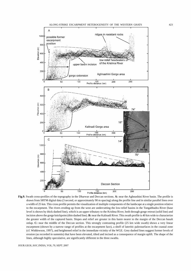
We may tentatively estimate the rate of Deccan scarpretreat using as a control the remnants of the lateritizedpediment belt that extends from the Konkan to Kerala(Widdowson and Gunnell, 1999). After Widdowson (1997)and Gunnell (2001), we interpret the sudden eastwardtermination of the laterite ramp as the trace of the formerescarpment (Fig. 9C). The ages of these residual lateritepediments are uncertain, but if we assume their minimumage is middle Miocene (Widdowson and Gunnell, 1999),then the scarp has retreated by 23 km in 13 m.y. Thistranslates as a rate of about 2 km/m.y. This (maximum) rateis clearly conditional upon both our palaeopositioning ofthe escarpment (cf. Fig. 9C) and the estimated age of thelaterite being correct. Given that rifting occurred at the K/Tboundary, the lateritized pediment cannot be more than ca.60 m.y. old, so a minimum rate of scarp recession wouldhave to be 23 km in 60 m.y., i.e. < 0.4 km/m.y. Assumingthat the overall Deccan section recession rate is equal to therecession in the coastal scarp of the gorge region, thenmaximum gorge extension is 20 km/m.y., while minimumrates would be 4 km/m.y. Gorge extension has a limit,however. As the gorge extends into the more semiarid zoneeast of the Western Ghats and the basin area above thegorge tip shrinks, the discharge energy diminishes and therate of extension will cease to outpace the rate of widening.At this point the basin will be “filling out” and loweringmuch of the upper reaches to the new base level of thenearby coast, which is ca. 500–800 m lower than the east-flowing streams. This seems to be the condition of a largeembayment south of the gorge area (see Fig. 3C, areamarked X). Here most of the basin has been excavatedand only a small portion of the basin lies near the formerbase level (see also stream #6, Fig.7).
Concurrent with the development of the gorge is theincision of the upper reaches of the captured basins. Thecross-section near the Aghnashini River, which has asmaller gorge, clearly shows the development of these twoforms of new relief (Fig. 9). The upper basin part of theeastern basin is steeper with greater relief, and thus incisionis likely proceeding faster here than in the low-reliefheadwaters of the Tungabhadra River, which flowsnortheastward across the plateau to join the Krishna and,eventually, the Bay of Bengal. Similar contrast in the east
and west styles of erosion are evident in the next swathprofile to the north (Fig. 9B). Here the eastern side issomewhat steeper, because the plateau relief increasesapproaching relict erosion surfaces near the southern endof the Deccan Section. However, the western flank of theupland is considerably steeper above the gorge. Both of theseprofiles contrast strongly with the sharp, strongly upliftedDeccan section profile of the WGE (Fig. 9C), where theescarpment is a narrow zone, no bevel due to capture andgorge extension cuts the edge of the escarpment, and reliefis greatly heightened in the area closest to the WGE.
DISCUSSION
The initial rift shoulder generated by the rifting away ofthe Madagascar and Seychelles plates has long been eroded(Gunnell et al. 2003), and the current Western Ghats likelyrepresent a residual escarpment that bears only distantrelation to the initial rift-flank scarp either in terms of reliefmagnitude or geographic position. However, this escarpmentis dynamic, and persists despite erosion relentlessly frayingthe plateau edge. A key engine to escarpment persistenceappears to be the monsoon climate since ca. 15 Ma, and(given the presence and antiquity of bauxites cappingthe Deccan basalts) its equally humid antecedents since60 Ma. The monsoon provides a plentiful supply of runoff,but more fundamental, as shown here, is the interplaybetween the drainage and geologic structure. Where bedrockis homogeneous both lithologically and structurally,as in the Deccan basalt province, the drainage divide andescarpment coincide, short-wavelength scarp sinuosity isminimal, and the width of the coastal plain varies little.When variability occurs at the basaltic escarpment, forinstance the large embayment northeast of Mumbai, wefind that the fracture net also exhibits a wider range ofazimuths. The geomorphological consequence is that thedrainage net, which is narrowly underprinted by thefracture net, has been presented with greater opportunitiesfor stream capture and overall scarp recession thanfurther south, where strike-parallel fractures are fewer(though conspicuous when present: cf. Fig. 4). Theseobservations also suggest that scarp sinuosity, which isoften used in morphometric studies to infer the relativeages of fault scarps, is an ambiguous measure of scarpage because structural factors may also mimic the agedependency that is commonly assumed in fault linedissection. In fact, Matmon et al. (2002) use sinuosity as asubstitute for margin age to infer a morphologic transitionwith age. Based on our data, we suggest that, at the localscale, escarpment sinuosity may appear and disappear as
JOUR.GEOL.SOC.INDIA, VOL.70, SEPT. 2007
ALONG-STRIKE ESCARPMENT HETEROGENEITY OF THE WESTERN GHATS 423
Fig.9. Swath cross-profiles of the topography in the Dharwar and Deccan sections. A: near the Aghnashini River basin. The profile isdrawn from SRTM digital data (3 second, or approximately 90 m spacing) along the profile line and in similar parallel lines overa width of 25 km. This cross profile permits the visualization of multiple components of the landscape at a single position relativeto the escarpment. The rivers eroding up from the west are undercutting the low-relief basins in the Tungabhadra River (baselevel is shown by thick dashed line), which is an upper tributary to the Krishna River, both through gorge retreat (solid line) andincision above the gorge knickpoint (thin dashed line). B: near the Kalinadi River. This swath profile is 40 km wide to characterizethe greater width of the captured basin. Slopes and relief are greater in this basin nearer to the margin of the Deccan basaltonlap. C: near the middle of the Deccan section. This strongly contrasting profile (25 km wide swath) shows a very linearescarpment (shown by a narrow range of profiles at the escarpment face), a shelf of lateritic paleosurfaces in the coastal zone(cf. Widdowson, 1997), and heightened relief in the immediate vicinity of the WGE. Grey dashed lines suggest former levels oferosion (as recorded in summits) that have been elevated, tilted and incised as a consequence of margin uplift. The shape of thelines, although highly speculative, are significantly different in the three swaths.
JOUR.GEOL.SOC.INDIA, VOL.70, SEPT. 2007
424 DAVID HARBOR AND YANNI GUNNELL
the drainage divide is driven across regions of variedstructure and lithology. Generally, it is the scarp-parallelfractures, and hence streams, such as the Koyna in theupland or a variety of similar streams in the coastal plateau(Fig. 1), that appear to play a major role in drainageintegration and scarp jumps. This counter-intuitive roleplayed by scarp-parallel streams, rather than just scarp-perpendicular trunk streams, has been mostly ignored inprevious studies of passive margin escarpments, but mayplay a far more general role than previously recognized.
Many feedbacks operate between geological conditionsand the geomorphic expression and evolution of the WGE.In the Dharwar Craton, lithological heterogeneity and folddirections in supracrustal rocks are much clearer controlson scarp sinuosity. The structural template involves scarp-parallel ridges of quartzite, which are clearly detectable inthe topography and locate strike-parallel streams that likelyplay a role analogous to the fractures mentioned in theDeccan lava pile. Whereas the rate of retreat is determinedby headward growth in most of the Deccan basalt section,this headward growth takes place in the face of drainageaway from the scarp and continued upwarp of the margin ina way that reinforces the persistence of the divide. Thus therelief seems to follow the morphology of the escarpmentand its erosion in a self-organized arrangement. Comingsouth into the Dharwar Craton, the retreat rate is lower dueto the shorter distance of the escarpment from the coast,and its lower relief. Even though the dominant rocks in thegorge section are less resistant (metagreywackes, meta-argilites), significant structural barriers may make thebackground rate of scarp retreat quite low. This appears tobe, however, punctuated by periods of extensive erosionfollowing drainage rearrangement and deep movement ofthe continental divide into the plateau, not by retreat but bydrainage capture, gorge extension, and basin expansion.Looking further south, the end result may be a realigning ofthe escarpment at a greater distance from the coast. Thegorge extension rate suggested here is quite high; it is tentimes the rate observed in the SE Australian passive margin(Weissel and Seidl, 1997), and possibly reflects thetremendous energy provided by 5 to 7 m of annual rainfallin the Indian case. If this rate is of the correct order ofmagnitude, then gorge extension is an indicator of the rapidjump that the WGE is about to take in the region between15 and 13ºN. Presumably, because the erosional unloadingis not taking place at a narrow and fixed distance from theWGE, the flexural response to this style of erosion will bedifferent, and may engender further responses of thegeomorphic system in the ongoing balance of uplift,erosional and escarpment retreat.
In summary, we find that the size of plateau drainage-basin annexation by river piracy affects the rate ofescarpment retreat. Annexation of large drainage basins suchas the Gangavali or the Sharavati potentially generates widesteps of scarp jump because it offsets the continental dividefar into the plateau interior. However, this process alsogenerates longer gorges piercing the plateau, so there is morework to be achieved in terms of gorge widening and a greatermass of trailing terrain to erode between the parallel gorgesbefore the escarpment can catch up with its relocated positionat the new continental divide. Logically, it takes much longerto achieve scarp migration than if scarp jumps occur onshorter length scales. We therefore suggest that gorge-typeescarpments are typical of drainage piracy having divertedbroad areas of plateau drainage, whereas divide-typeescarpments reflect either (i) shorter jumps (for instance ofthe kind detectable in Figure 4, where strike-parallel fracturespacing north of Chiplun is ca. 5 km and does not muchexceed 15 km), or (ii) situations where girdles of highlyresistant rocks generate stagnant escarpments with littlechance of recession (e.g. the Kudremukh “headland”, whichcorresponds to a continuous BIF and quartzite hogackstructure towering at nearly 2 km a.s.l., “K” on Fig. 1). Thisdoes not mean that scarp recession in divide-type settingsdoes not also involve gorge cutting followed by gorgewidening, but we suggest that the gorges are much shorterin length and poorly distinguishable from the backgroundnoise of scarp sinuosity. Such gorges, which occur inhomogeneous geologic settings (here: the Deccan basalts)would also be shorter-lived because relaxation times betweenthe drainage piracy event and the scarp reformation eventat the new drainage divide are much shorter than in gorge-type settings with hetoerogeneous lithologies. Because thegorges are much shorter-lived, there is a much higherprobability of there not being any conspicuous gorge at agiven time, hence the divide-type morphology. In that sense,we suggest that river capture and drainage rearrangement isone end member of the normal mode of escarpment retreatat mature passive margins, and that divide-type escarpmentssimply represent the other end member of this model wheneither homogeneous bedrock conditions or structuralblocking by a large resistant bedrock landform occur. Alongthe length of the WGE, averaging the various sinuosity linesshown on Figure 2 suggests that the average overall pace ofscarp retreat is uniform but that variation of rate increasesin the gorge-type end member. Significant variance in scarpmorphology is therefore not necessarily an indication ofheterogeneous mean rates of retreat. Further work is neededto test whether all linear escarpments are stagnant (Biermanand Caffee, 2001); or whether, as we hypothesize here, the
JOUR.GEOL.SOC.INDIA, VOL.70, SEPT. 2007
ALONG-STRIKE ESCARPMENT HETEROGENEITY OF THE WESTERN GHATS 425
retreat of the linear Deccan section is equal to that of theother sections because the long-term average recession-rate homogenizing factor is the fairly uniform monsoonclimate along the entire strike of the Ghats. Nevertheless,it is clear from the topographic analysis that the gorge-type escarpment is likely to recede by a significant amountat geologic time scales. In that respect, the dynamics ofdivide-type escarpments are more ambiguous to tracethrough space and time unless, as we proposed earlier(cf. Fig. 9C), geomorphic traces of its paleoposition can beascertained.
CONCLUSION
From the maps and diagrams crafted for this study,insight has been gained into the dynamics of a continental-scale great escarpment. We suggest that in areas ofheterogeneity, scarps recede in jumps driven by drainagecapture rather than by parallel scarp retreat. The persistenceof parallel scarp retreat in the Deccan basalts, for instance,is conveyed by the current coincidence of the scarp and thedrainage divide as well as relative scarp rectitude. We arguethat those attributes are made possible by the collaborationbetween fracture-guided scarp-perpendicular and scarp-parallel streams; and by geological homogeneity, whichdenies erosional advantage to any one stream while alsoallowing a more rapid and uniform destruction of the residualtopography that survives on the coastal plain in the wake ofthe successive scarp jumps. In the Dharwar Craton,geological heterogeneity is the engine for drainagerearrangement. Given that monsoon rainfall provides themain fuel for river discharge and cutting power, climaticaridity in the escarpment rainshadow is potentially themain limitation on indefinite gorge recession into the
interior. However, we have seen that the gorge section ofthe Ghats is also that of lowest relief (0.4–0.5 km), andhence the weakest barrier to monsoon rainfall. The presenceof the gorges at those latitudes is a chicken or egg issuethat is not easily resolved: did the gorges make inroadsbecause the Ghats form a topographic saddle that allowsmonsoon flow to enter the plateau? Or does the saddleexist because the argillites and greywackes of that segmentwere more easily eroded compared to areas to the northand south of this zone? Or is the low relief a response todelayed erosion and a limited flexural response to erosiondistributed across a broader zone? Passive margin scarpevolution cast in terms of rift-flank decay and isostaticadjustments appear valid for the initial few tens ofmillions of years when the initial rift shoulder loses severalkilometres of rock. However, when magnitudes of erosiondrop significantly once the shoulder has been eroded(Gunnell et al., 2003), the scarp finds a new topographicstate similar to the one currently observed and thehierarchy of driving mechanisms changes. We suggestthat site-specific feedbacks between climate, drainage, andgeological structure along the strike of continuousescarpments at mature passive margins are key tounderstanding scarp dynamics and scarp persistence.The manner in which the evolution of drainage boundariesacross strike affect morphology and the distribution ofisostatic rebound along strike seem essential.
Acknowledgements: We wish to thank Narayana Allufor soliciting our contribution to this Special Volume onSahyadri, and Vishwas Kale for his formal review of themanuscript. We dedicate this paper to B.P. Radhakrishna,whose past pioneering insights into the Western Ghatshave spawned much interest world wide.
References
BIERMAN, P.R. and CAFFEE, M. (2001) Slow rates of rock surfaceerosion and sediment production across the Namib desert andescarpment, Southern Africa. Amer. Jour. Sci., v.301, pp.326-358.
CHETTY, T.R.K. (1996) Proterozoic shear zones in southerngranulite terrain, southern India. In: M. Santosh and M.Yoshida, M. (Eds.), The Archean and Proterozoic terrains ofsouthern India within eastern Gondwana. Gondwana ResearchGroup Memoir, v. 3, Faculty of Science, Osaka University,pp.77-90.
GOLDRICK, G. and BISHOP, P. (1995) Differentiating the roles oflithology and uplift in steepening bedrock river long profiles:an example from Southeastern Australia. Jour. Geol., v.103,pp.227-231.
GUNNELL, Y. (2001) Morphology and scarp recession rates ofthe Western Ghats escarpment. In: Y. Gunnell andB.P. Radhakrishna (Eds.), Sahyadri, the Great Escarpment ofthe Indian Subcontinent. Patterns of Landscape Developmentin the Western Ghats. Mem. Geol. Soc. India, No.47,Bangalore, pp.89–117.
GUNNELL, Y. and RADHAKRISHNA, B.P. (Eds) (2001) Sahyadri, theGreat Escarpment of the Indian Subcontinent. Patterns ofLandscape Development in the Western Ghats. Mem. Geol.Soc. India, No.47, Bangalore, 1054p.
GUNNELL, Y., GALLAGHER, K., CARTER, A., WIDDOWSON, M. andHURFORD, A.J. (2003) Denudation history of the continentalmargin of western peninsular India during the Mesozoic andCenozoic. Earth Planet. Sci. Lett., v.215, pp.187-201.

JOUR.GEOL.SOC.INDIA, VOL.70, SEPT. 2007
426 DAVID HARBOR AND YANNI GUNNELL
JET PROPULSION LAB (2002) http://www2.jpl.nasa.gov/srtm/index.html
MATMON, A., BIERMAN, P. and ENZEL, Y. (2002) Pattern and tempoof great escarpment erosion. Geology, v.30, pp.1135-1138.
RADHAKRISHNA, B.P. (1964) Evolution of Sharavati drainage, MysoreState, South India. Jour. Geol. Soc. India, v.5, pp.72-79.
SRTM (2004) ftp://edcftp.cr.usgs.gov/pub/data/srtmTUCKER, G.E. and SLINGERLAND, R.L. (1994) Erosional dynamics,
flexural isostasy, and long-lived escarpments: a numericalmodeling study. Jour. Geophys. Res., v.99, pp.12229-12243.
WANDREY, C.J. and LAW, B.E. (1998). Maps showing geology, oiland gas fields and geologic provinces of South Asia, USGeological Survey Open-file Report 97-470C. Digital dataretrieved from http://energy.cr.usgs.gov/energy/WorldEnergy/WEnergy.html, June, 2003.
WEISSEL, J.K. and SEIDL, M.A. (1997) Influence of rock strengthproperties on escarpment retreat across passive continentalmargins. Geology, v.25, pp.631-634.
WIDDOWSON, M. (1997) Tertiary palaeosurfaces of the SW Deccan,Western India: implications for passive margin uplift. In: M.Widdowson, (Ed.), Palaeosurfaces: Recognition,Reconstruction and Palaeoenvironmental Interpretation. Geol.Soc. London Spec. Publ., v.120, pp.221-248.
W IDDOWSON, M. and GUNNELL , Y. (1999) Lateritization,geomorphology and geodynamics of a passive continentalmargin: the Konkan and Kanara coastal lowlands of westernpeninsular India. In: M. Thiry, and R. Simon-Coinçon (Eds.),Palaeoweathering, Palaeosurfaces and Related ContinentalDeposits, Internat. Assoc. Sediment., Spec. Publ., v.27, pp.245-274.