Embed Size (px)
Citation preview

Aroostook County Region
Directions Access to the Waterway is over private roads that are managed and main-tained by the landown-ers, organized together as North Maine Woods, Inc. They monitor vehicle access through a series of checkpoints. Fees are charged.
Chamberlain Bridge Latitude / Longitude: 46.170889 /-69.208944
FeesNorth Maine Woods Fees: www.northmainewoods.orgAWW Camping Fee: www.maine.gov/allagash
ContactsBureau of Parks and Lands Northern Region Office 106 Hogan Road, Suite 7 Bangor, ME 04401 (207) 941-4014 www.maine.gov/allagash
Allagash Wilderness
Waterway
guide & map
Iconic paddling on a
Wild and Scenic River
CampsitesEighty-one fire safe, authorized campsites are located through-out the Waterway. When approaching from the water, you will see that they are clearly marked with a triangular sign.
• Camping is permitted only at these sites. • All sites are equipped with tables, tarp poles, fireplaces, and an outhouse.
Maine Department of Agriculture, Conservation and Forestry
Bureau of Parks and Landswww.parksandlands.com
Canoe Trips • Because “ice-out” does not occur until early to mid-May,
canoe trips should not be attempted before May 15.
• Subscribe to the Waterway Conditions & Alerts at www.maine.gov/allagash
• Plus view online:
• Allagash Video
• Campsites via Google Earth
• Children can safely make the trip under proper adult supervision.
• A portage service is available from 8:00 am until noon at Churchill Dam for a small fee. Canoeists who do not wish to run Chase Rapids or would like their gear shuttled around the rapids should plan accordingly.
• Canoeists will find that the canoe route through the Waterway is not marked by signs.
Partners and Supporters This brochure was made possible in part by funding assistance through the Federal Highway Administration’s Recreational Trails Program, administered by the Maine Bureau of Parks and Lands.
Black Bear (Ursus americanus). Photo by Steve Day.
Welcome
For more than a century “the Allagash” has been praised and enjoyed as a sportsman’s paradise. Many famous people, including Henry David Thoreau, have enjoyed
its beauty and come away filled with determination to protect it for future generations. The people of Maine made what these men dreamed a reality. The State of Maine, through the Bureau of Parks and Lands within the Department of Agriculture, Conservation and Forestry, seeks to ensure that this area will be maintained forever as a place of solace and refuge.
The Allagash Wilderness Waterway was established by the Maine Legislature in 1966 to preserve, protect, and enhance the wilderness character of this unique area. It is a magnificent 92-mile-long ribbon of lakes, ponds, rivers, and streams winding through the heart of northern Maine’s vast commercial forests. Protection of the Waterway was further enhanced in 1970 when it was named the first state-administered component of the National Wild and Scenic River System by the United States Department of the Interior.
The permanent residents in this area are the animals and plants; visitors show respect and care by leaving the fewest possible signs of their presence.
Access & ParkingPrivate roads provide access to the Waterway and are maintained by the landowners for rapid transit of logging trucks.
• Logging Trucks have right of way at all times.
• North Maine Woods checkpoints monitor access and collect fees. For maps, rules, and road conditions: www.northmainewoods.org
• Registration is Required for everyone entering the Waterway. Visitors must register at the first opportunity at a North Maine Woods checkpoint or with the first Waterway Ranger encountered. (See map for Ranger Station locations.)
• Vehicle Access Points provide the easiest access for mobility impaired people. FMI: (207) 941-4014
• Parking Areas are designated; return transport to points of departure should be arranged in advance.
• A list of Licensed Outfitters & Guides is available from North Maine Woods at: www.northmainewoods.org.
• Watercraft with Motors must be registered with the Maine Department of Inland Fisheries and Wildlife. FMI: www.maine.gov/ifw
• Launch Sites, hand-carry and trailerable, are highly variable; see map or use the Online Sortable Launch Listing: www.maine.gov/dacf/boatlaunches
• Aircraft Access to the Waterway by aircraft is limited to a few designated sites. (Rules at www.maine.gov/allagash)
• Allagash Wilderness Waterway Conditions & Alerts: www.maine.gov/allagash (With option to subscribe to Alerts)
When To Visit Climate, Environment & Wildlife
OverviewThe Allagash is not a wilderness in the sense of it being untouched by humans. It is a wilderness in that any time of year visitors may experience living under largely natural conditions, in striking contrast to the modern world’s human environment. The Waterway’s limited facilities will be appreciated by visitors who seek solitude and self-reliance. There is no public transportation; access is limited to gravel roads; camping facilities are primitive. Internet connectivity and cell phone coverage is nonexistant.
The key to an enjoyable and successful Allagash trip is careful advance planning. Thoughtful attention to detail and a realistic trip itinerary are important aspects of a pleasurable and safe Waterway adventure.
Long Lake Dam. Photo by Rex Turner
Conditions www.maine.gov/allagash
• The Allagash is a wilderness wonderland for year-round camping and recreation. • Weather conditions are variable throughout the year; cool is the rule. • Caution and self-reliance is mandatory.Season Spring/ • Ice out is in early or mid-May. Summer • Black fly season starts about June 1 and begins to abate by the first part of July. • Peak fishing is generally ice out to July. • Water levels are highest during the spring. Autumn • Great paddling amidst fall colors; water levels may be low; check conditions at www.maine.gov/allagash • Firearms are not allowed until October 1st, when the Waterway is open to general hunting. FMI: www.maine.gov/ifw
Winter • For only the most skilled and hardy. Snowmobile use has increased visitation during this season. Ride safely; help is not readily available. • No marked trails except the single trail used to access Chamberlain Lake. • Thin ice and some open water should be expected in the thoroughfares, where the current keeps ice from forming. • Warming fires may be built in campsite fireplaces or below the high water mark to avoid scarring the shore.
The locomotives at Eagle Lake. Photo by Kevin Brown.
Moose (Alces alces americana). Photo by Steve Day.
Paddling the Allagash. Photo by Steve Day.
Organized GroupsTo preserve the Allagash Wilderness Waterway (AWW) experience:
• Group Size is strictly limited to 12 persons.
• Groups of more than 12 people must separate into smaller groups and travel and camp separately.
• Boy Scout and Girl Scout groups are reminded to obtain a local or national tour permit in compliance with scouting regulations.
• Trip leaders of organized youth groups are required by law to obtain a permit from the Maine Department of Inland Fisheries and Wildlife. FMI: www.maine.gov/ifw
Umsaskis Lake. Photo by Steve Day.
RulesThe rules governing the Allagash Wilderness Waterway (AWW) have been established to protect visitors and the wilderness character of the Waterway. These rules contain important information on several subjects, such as the limitations placed on the use of boats, motors, and canoes. Please refer to the rules when planning your trip.
AWW Rules are available:
• Online at www.maine.gov/allagash
• By contacting the: Northern Region Office, Bureau of Parks and Lands, 106 Hogan Road, Suite 7 Bangor, Maine 04401 (207) 941-4014
North Maine Woods checkpoints monitor access and collect fees. For their maps, rules, and road conditions visit www.northmainewoods.org
Fire: Campfires may be built only in the fireplaces provided. Use only small downed wood; no cutting of green/live trees or vegetation. Because uncontrolled wildfire is extremely dangerous, campers should keep fires small and constantly tended. Before leaving your campfire drown it with water and stir until you can place your hand in the ashes.
Water: Tested public drinking water is available at Chamberlain Bridge and Churchill Dam. Other water sources should not be considered safe. Take appropriate precautions such as: filtration pumps, boiling, or adding a purifying agent. Springs should not be regarded as safe drinking water.
Washing: Dishes and clothing should be washed in a container away from lakes and streams. Personal washing should also be done from a basin or bucket. Wash water should be disposed of by dispersing on the ground at least 100 feet from the lake, river, or any other water source. This will help prevent waste, soap, and detergents – which stimulate the growth of algae – from degrading the water of the Allagash.
Toilets: Outhouses are provided at all campsites and most access points in the Waterway. Should “nature call” and an outhouse is not available, a shallow hole should be dug at least 100 feet from the water. Fill the hole with soil before leaving the area.
Trash: The Allagash is a carry-in carry-out waterway. Plan ahead to reduce waste: avoid disposables and excessive packaging. Overnight, hang waste bags high and away from your campsite to keep animals out of the trash.
Closed Sites: From time to time waterway management may close campsites for repairs or renovations. Closed sites will be posted “Closed." Camping at these sites is not allowed during the repairs.
Recreational ActivitiesBesides the enjoyment of camping, canoeing, and just being “away from it all”, visitors will find other recreational activities in the Waterway.
• Hiking trails to the fire towers will afford visitors a fine view of the surrounding lakes and woodlands. • An official geocache is hidden along the Waterway. FMI: www.maine.gov/dacf/geotour• Stamp your park passport booklet at these Ranger Stations: Chamberlain Bridge, Churchill Dam, Umsaskis, and Michaud Farm. FMI: www.maine.gov/dacf/parkpassport.• Firearms are not allowed in the Restricted Zone from May 1 to September 30; the Restricted Zone is closed to all hunting during this period. • Hunting in season, with proper licenses, is allowed. • Brook trout, togue, and lake whitefish are plentiful. Licensed fishermen are encouraged to try their luck*. • Hunting and fishing laws are available in booklets from the Maine Department of Inland Fisheries and Wildlife or online at: www.maine.gov/ifw.
*Allagash Falls forms a natural barrier to the upstream migration of warm water fish species. Native cold water fisher-ies thrive above Allagash Falls. Please do not dump pails of bait in the Waterway. Your cooperation will preserve the native fisheries of the Allagash for future generations.
Allagash Falls. Photo by Steve Day.
Brook Trout (Salvelinus fontinalis).
HistoryEarliest HistoryThe last Ice Age left a tundra-like environment in nortern Maine that yielded to dense forest about 10,000 years ago. Though a few families of Paleoindians may have traveled through the Allagash region at that time, the archaeological record shows a larger population during the Archaic period, approximately 10,000 to 4,000 years ago. The people of this era were generally nomadic, using nets for fishing and stone or wood for tools. Most plentiful among the artifacts discovered from this period are stone axes and gouges for woodworking. Between 4,000 and 3,500 years ago these types of tools became less common, suggesting a shift from dugout canoes to
a birch bark type. This shift is also supported by the many sites archaeologists have found in drain-age areas where heavier dugouts would have been difficult to use.
The Ceramic Period of 3,000 to 500 years ago is named for the emergence of the use of pottery. Though not very durable at this point, pottery enabled cooking directly on the fire, rather than the labor-intensive method of heating stones and placing them into a bark or wooden container. Although ceramic artifacts do not survive well in the conditions of the Allagash region, archaeologists have found pottery in the region at least 2,000 years old.
The archaeological record seems to indicate that traditional Native Americans began to move away from the Allagash region early in the 1800s. The Waterway’s Native American heritage is found in the names of its places, such as Umsaskis Lake and Musquacook Stream.
Henry David Thoreau visited the Allagash in 1857 with Penobscot guide Joe Polis. Among other sites, they made camp on Pillsbury Island in Eagle Lake near what is now Thoreau campsite.
Read Thoreau's The Maine Woods to learn more about his journeys in Maine.
The Logging EraShortly after Maine became a state in 1820, David Pingree, a businessman from Salem, Massachusetts foresaw the demise of his hometown as a major shipping port. Worried about the future value of his vast shipping enterprises, he looked elsewhere for investment opportunities. His keen eye for commerce eventually settled upon the seemingly unending tracts of timber-covered land in the northern half of Maine.
Basing his new enterprise in Bangor, a town that hosted more than three hundred sawmills by the mid-1830s, Pingree, under the guidance of his partner Eben Coe, began to profit handsomely from his operations- harvesting trees from the virgin wilderness, running them down river to Bangor where they were milled into lumber and put aboard ships that could carry them wherever a market beckoned.
A major impediment that limited the Bangor lumber inter-ests’ ability to profit from Allagash timber was the fact that the water flowed northward into the St. John River. Once there, it could be turned into lumber in mills but the only transporta-tion route to sea was by way of British-controlled seaports in Canada. Nature’s intended course for the waterway was not enough however, to deter the lumber barons for long.
People whose ingenuity was only exceeded by their vision of large profits scoffed at Mother Nature’s plan for the river and sought to reverse the course of its flow, from northward to southward. By raising the level of the lakes and shifting the direction of the river current to the south, logs could be driven down East Branch of the Penobscot River to Bangor where American millers and shippers could profit.
In 1838, the owners of Township 6 Range 11 asked Shepard Body to devise a way to move logs from Chamberlain Lake into Telos Lake, then down East Branch of the Penobscot. Body proposed the raising of waters in Chamberlain Lake via a dam and then the digging of a canal across the space between Telos and Webster Lakes. This area included a ravine that dropped approximately 47 feet into Webster Lake. By fall 1841, Lock and Telos Dams were in place and a canal ten to fifteen feet wide and one to six feet deep stretched the 500-feet from Telos Lake to Webster Stream. It was thereafter known as the Telos Cut.
Thoreau
2016
Official Maine State Parks Geocache: www.maine.gov/dacf/geotour
Lock Dam circa early 1900s; AWW file photo.
With the reversing of the flow of water in Chamberlain and Telos Lakes, logs could be cut and run via the log drive from Allagash Lake all the way to Bangor!
Today, there are rebuilt dams at Churchill, Chamberlain (Lock Dam), and Telos that regulate water levels for recreation and fisheries habitat. Remnants of the old Long Lake Dam can be seen at the outlet of Harvey Pond.
The most striking lumbering era relics in the Waterway are found at the stretch of land that separates Chamberlain and Eagle Lakes- known as the Tramway Historic District, a National Historic Site with remnants of the tramway and the Eagle Lake & West Branch Railroad.
The tramway is a unique log moving devise that consisted of two levels of small railroad “trucks” attached to a 6000 foot long steel cable. The drive mechanism was powered by a steam engine and boilers located near the shore of Chamberlain Lake. Logs were loaded onto the trucks and traveled on the upper level, from Eagle to Chamberlain Lake, a distance of 3000 feet. After the logs were dumped into Chamberlain Lake, the empty trucks returned upside down on the lower level back to Eagle Lake.
During the winter of 1926-1927, Edouard “King” LaCroix, hauled all the materials used to build the Eagle Lake & West Branch Railroad from Lac Frontier, Quebec. The railroad was used to haul four foot pulpwood from Eagle Lake to Umba-zooksus Lake- a distance of 13 miles- where the wood was then transported via log drive to the paper mill in Millinocket. In an average week, 6,500 cords of pulpwood moved across the tracks. When the railroad operation ended in 1933, the locomotives were obsolete and not worth transporting for re-use elsewhere.
Another innova-tion that aided logging in the Allagash was the Lombard Log Hauler, precursor of every track-driven vehicle in the world. Invented and built in Maine, these huge machines allowed loggers to move their timber without the use of animals or the need to build a railroad wherever they worked.
With lumber operations expanding and reaching more deeply into the region, farms sprang-up to provide hay and oats for the workhorses and winter vegetables for the lumber crews.
Lombard Log Hauler; AWW file photo.
GearA canoe trip in the Allagash need not be a survival test. Prior camping experience will be a good guide to determining your basic needs. Remember that once you are in the Waterway, there will be no opportunity to get items you have overlooked.
Consider this list of equipment in planning your trip:HatSunglassesSunscreenRaingearBoots, mocs, sneakersExtra clothingCan openerCooking/eating utensilsPailSewing kitFirst aid kitInsect repellentCompassGPS unit Maps
FlashlightMatches or lighterCamp stove and lampLiquid fuelWater filtration pumpSleeping bag and padTarpTentToilet paperTowelsBiodegradable soap Canoe patching materialPole, 10-12’Supply of 1/4” ropeExtra paddle
AxCamp sawKnifeWhetstoneKnapsack/pack basketTrowelZipper seal bags
Life preservers – At least one Coast Guard-approved wearable personal flotation device per person (required by law). Low-Impact Camping
Human use of a wilderness area is bound to have some impact, but you can reduce your impact by careful planning and thoughtful use. Please consider the following tips, and consult a handbook on low-impact camping before your trip.
• Choose reusables over disposables, especially for dishes and silverware. Avoid disposable flashlights, butane cylinders, and Sterno cans.
• Camp stoves have less impact on the wilderness than campfires made from wood gathered there. Choose refillable liquid-fuel stoves and lanterns over dangerous butane cylinder models.
• If you make a campfire, use only small downed wood. Campfires must be supervised at all times.
• Burn only local fire wood to help stop the spread of invasive insects. See www.maine.gov/forestpests Out-of-State firewood is banned.
• Burn only paper waste. Plastic, foil, cans, and food scraps do not burn.
• Use only phosphate free soaps/detergents to wash dishes, clothes, and yourself in a basin away from the water. Dump waste water into a pit toilet, or disperse on the ground away from the campsite at least 100 feet from the water.
• If you need plastic to keep things dry, use and reuse durable plastic.
• Avoid trenching; choose higher ground for wet weather tenting.
• Sleep on a pad or air mattress, not gathered leaves or evergreen needles.
• Wear shoes and boots with low-profile treads that churn up less soil.
• Buy food in bulk and avoid individual and excessive packaging.
• Use powdered soft drinks to avoid cans, bottles, and foil-lined boxes.
• Bring food in reusable containers and resealable plastic bags; reuse them.
• Seal food wastes in a bag; take home and compost.
• Rinse and flatten cans; take home to recycle.
• Keep animals out the trash by hanging the bag high and away from the campsite.
• Carry out all of your trash.
North Maine Woods, Inc. P.O. Box 421 Ashland, ME 04732 (207) 435-6213 www.northmainewoods.org
Maine Department of Inland Fisheries and Wildlife State House Station 41 Augusta, ME 04333 (207) 287-8000 www.maine.gov/ifw
Photo courtesy of Allagash Canoe Trips.
Emergency Assistance Radio Dispatch Center (207) 435-7963 M-F, 8-5
Weekends & Off-hours: State Police Dispatch Center (207) 532-5400, or 1-800-924-2261 (in-state only)
Photo by Deborah Gardner
These farms became supply points for logging activity in the area. Some of the more significant farms on the Waterway were located at: Chamberlain Farm, Churchill Depot, Harvey Farm, Michaud Farm, and the Moir Farm.
Timber Management on Maine’s Public LandsThe Bureau of Parks and Lands (BPL) manages its public lands to achieve multiple benefits: public recreation, wildlife habitat and timber sales (revenues from which help fund land manage-ment). The Bureau adheres to strict practices in selectively harvesting timber, minimizing runoff and soil erosion, and taking other measures to ensure that the health of the larger ecosystem is maintained. BPL’s forest practices are green-certified by two independent auditors: •The Forest Stewardship CouncilTM
•The Sustainable Forestry InitiativeTM
Um
sask
is La
ke co
ver p
hoto
by S
teve D
ay.
Legendar
Big Rapids
CaseyRapidsEliza Hole
Rapids
Twin Brook Rapids
Spring Bank Rapids
McGargle Rocks
Round PondRips
Rapids
Rapids
Rapids
Chase Rapids
McKeenLake
PriestlyLake
LongleyPond
Webster Lake
LittleShallow
Lake
DaggettPond
RoundPond
PolandPond
JohnsonPond
UpperEllis
Pond
LittleEllis
Pond
OtterPond
LittleRoundPond
Mile Pond
Narrow Pond
UpperRussellPond
LowerRussellPond
ClarksonPond
RoundPond
RussellCove
MidnightPond
Lost Pond
Ellis Bog
Co�eelosPond
LittleLeadbetter
Pond
HeronLake
MusquacookDeadwater
ClearLake
Fourth
Third
Fifth
Pleasant Lake
Harrow Lake
Spider Lake
UmsaskisLake
Long Lake
HarveyPond
RoundPond
ChurchillLake
Eagle La k e
Indian Pond
Chamberlain Lake
MudPond
Umbazooksus Lake
ChesuncookLake
RoundPond
Telos Lake
Haymock Lake
Cuxabexis Lake
CaucomgomocLake
Black Pond
ShallowLake
AllagashLake
Midnight Brook
Smith Brook
Mud Brook
Kellogg Brook
Lead
better B
rookLeadbetter
Pond
LittleIndianPond
WoodmanPond
Woodman Brook
Indian Stream
MartinCove
Ellis Brook
Fox Brook
Ha�ord Brook
West Twin Brook Gerald Brook
East Twin Brook
Brow
n Br
ook
Little McKinnon Brook
Big Brook
McKeen Brook
Ram
say Brook
Bass BrookBurntland Brook
Farm Brook
Ben Glazier Brook
McKinnon Brook
Bogan Brook
Savage Brook
Musquacook Stream
Croque BrookChase Brook
Schedule Brook
Gam
ash BrookWhitaker Brook
Harding Brook Sweeney Brook
Henderson Brook
Shepherd Brook
ChemquasabamticookStream
Grey Brook
Squirrel BrookThe Thoroughfare
Searway Brook
Conner Brook
Hesse Brook
Halfway Brook
FirstSecond
Musquacook Lakes
Glazier Pond
Glazier Brook
N. Br. G
lazier Brook
Chishol
m B
rook
Drake Brook
McCluskey Brook
Allagash River
LittleChurchill
Pond
Harrow
Br
ook
Pleasant StreamChurchill BrookThoroughfare Brook
N. Twin Brook
S. Twin Brook
Russell Brook
Mile Brook
Soper Brook
Otter Brook
TwinLake
Cli�Lake
SoperPond
LittleAllagash
Falls
Smith Brook
AllagashStream
CissStream
AllagashFalls
Arm of Chamberlain
Umba
zook
sus S
trea
m
St. Jo
hn River
A lla
gash
River
Alla
gash
River
Allagash River
St. John River
(2.5 miles)
Chamberlain Bridge
Michaud Farm (1)
FinleyBogan
Henderson Bridge
Allagash Wilderness Waterway
Other Public Lands
Waterway Ranger Camp
Canoe Access
Trailerable Boat Launch
Portage
Waterway Campsites(number of cells)
Other Campsite
Sporting Camp (private)
Fire Tower
FallsDanger
Rapids
Town Line
Parking
Allagash Wilderness Waterway
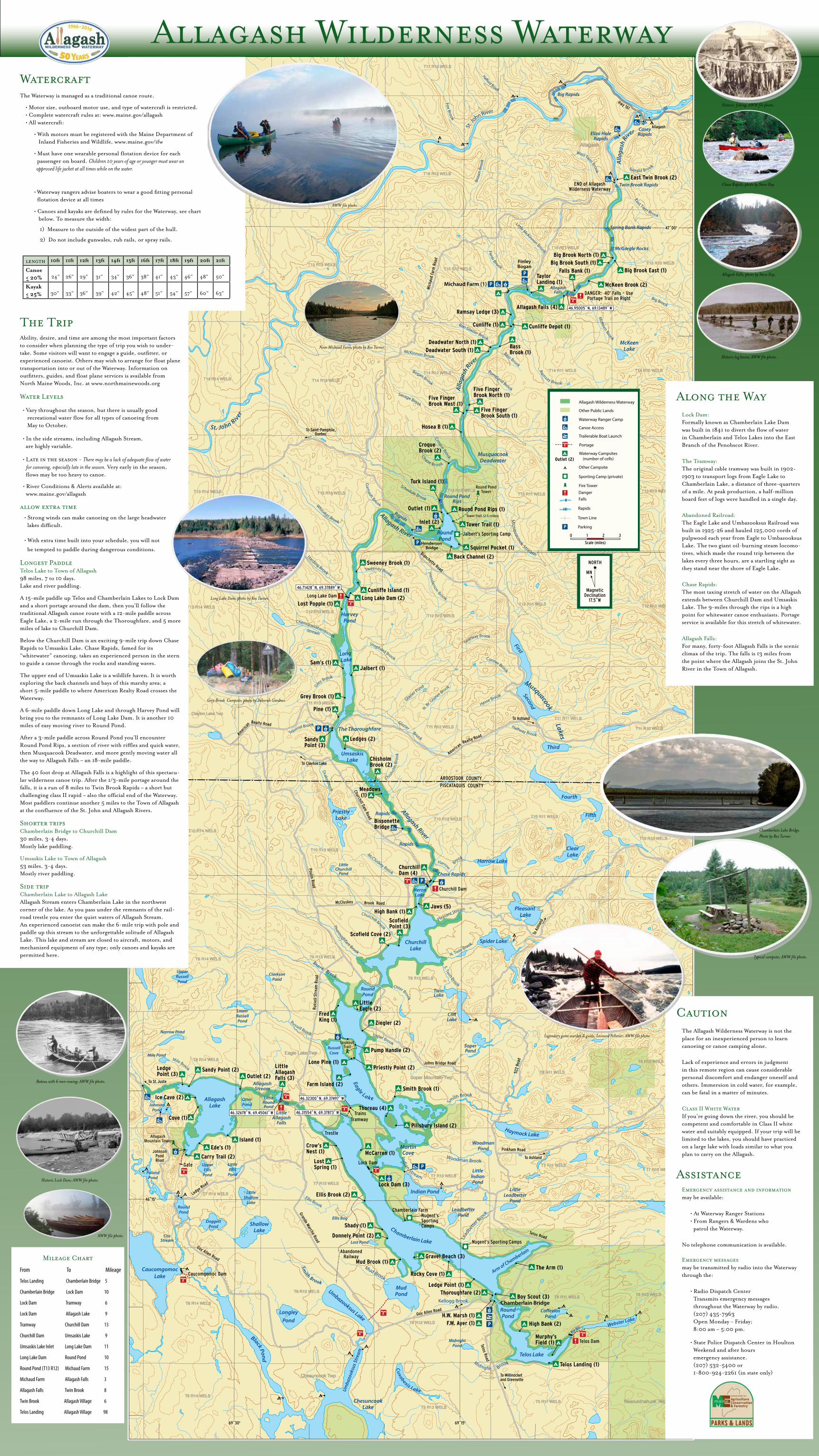
WatercraftThe Waterway is managed as a traditional canoe route.
• Motor size, outboard motor use, and type of watercraft is restricted. • Complete watercraft rules at: www.maine.gov/allagash • All watercraft:
• With motors must be registered with the Maine Department of Inland Fisheries and Wildlife, www.maine.gov/ifw
• Must have one wearable personal flotation device for each passenger on board. Children 10 years of age or younger must wear an approved life jacket at all times while on the water.
• Waterway rangers advise boaters to wear a good fitting personal flotation device at all times
• Canoes and kayaks are defined by rules for the Waterway, see chart below. To measure the width:
1) Measure to the outside of the widest part of the hull.
2) Do not include gunwales, rub rails, or spray rails.
length 10ft 11ft 12ft 13ft 14ft 15ft 16ft 17ft 18ft 19ft 20ft 21ft
Canoe < 20% 24" 26" 29" 31" 34" 36" 38" 41" 43" 46" 48" 50"
Kayak < 25% 30" 33" 36" 39" 42" 45" 48" 51" 54" 57" 60" 63"
The TripAbility, desire, and time are among the most important factors to consider when planning the type of trip you wish to under-take. Some visitors will want to engage a guide, outfitter, or experienced canoeist. Others may wish to arrange for float plane transportation into or out of the Waterway. Information on outfitters, guides, and float plane services is available from North Maine Woods, Inc. at www.northmainewoods.org
Water Levels
• Vary throughout the season, but there is usually good recreational water flow for all types of canoeing from May to October.
• In the side streams, including Allagash Stream, are highly variable.
• Late in the season - There may be a lack of adequate flow of water for canoeing, especially late in the season. Very early in the season, flows may be too heavy to canoe.
• River Conditions & Alerts available at: www.maine.gov/allagash
allow extra time • Strong winds can make canoeing on the large headwater lakes difficult. • With extra time built into your schedule, you will not
be tempted to paddle during dangerous conditions.
Longest Paddle Telos Lake to Town of Allagash 98 miles, 7 to 10 days. Lake and river paddling.
A 15-mile paddle up Telos and Chamberlain Lakes to Lock Dam and a short portage around the dam, then you'll follow the traditional Allagash canoe route with a 12-mile paddle across Eagle Lake, a 2-mile run through the Thoroughfare, and 5 more miles of lake to Churchill Dam.
Below the Churchill Dam is an exciting 9-mile trip down Chase Rapids to Umsaskis Lake. Chase Rapids, famed for its “whitewater” canoeing, takes an experienced person in the stern to guide a canoe through the rocks and standing waves.
The upper end of Umsaskis Lake is a wildlife haven. It is worth exploring the back channels and bays of this marshy area; a short 5-mile paddle to where American Realty Road crosses the Waterway.
A 6-mile paddle down Long Lake and through Harvey Pond will bring you to the remnants of Long Lake Dam. It is another 10 miles of easy moving river to Round Pond.
After a 3-mile paddle across Round Pond you'll encounter Round Pond Rips, a section of river with riffles and quick water, then Musquacook Deadwater, and more gently moving water all the way to Allagash Falls – an 18-mile paddle.
The 40 foot drop at Allagash Falls is a highlight of this spectacu-lar wilderness canoe trip. After the 1/3-mile portage around the falls, it is a run of 8 miles to Twin Brook Rapids – a short but challenging class II rapid – also the official end of the Waterway. Most paddlers continue another 5 miles to the Town of Allagash at the confluence of the St. John and Allagash Rivers.
Shorter trips Chamberlain Bridge to Churchill Dam 30 miles, 3-4 days. Mostly lake paddling.
Umsaskis Lake to Town of Allagash 53 miles, 3-4 days. Mostly river paddling.
Side trip Chamberlain Lake to Allagash Lake Allagash Stream enters Chamberlain Lake in the northwest corner of the lake. As you pass under the remnants of the rail-road trestle you enter the quiet waters of Allagash Stream. An experienced canoeist can make the 6-mile trip with pole and paddle up this stream to the unforgettable solitude of Allagash Lake. This lake and stream are closed to aircraft, motors, and mechanized equipment of any type; only canoes and kayaks are permitted here.
Mileage Chart
From To Mileage
Telos Landing Chamberlain Bridge 5
Chamberlain Bridge Lock Dam 10
Lock Dam Tramway 6
Lock Dam Allagash Lake 9
Tramway Churchill Dam 13
Churchill Dam Umsaskis Lake 9
Umsaskis Lake Inlet Long Lake Dam 11
Long Lake Dam Round Pond 10
Round Pond (T13 R12) Michaud Farm 15
Michaud Farm Allagash Falls 3
Allagash Falls Twin Brook 8
Twin Brook Allagash Village 6
Telos Landing Allagash Village 98
Along the WayLock Dam: Formally known as Chamberlain Lake Dam was built in 1841 to divert the flow of water in Chamberlain and Telos Lakes into the East Branch of the Penobscot River.
The Tramway: The original cable tramway was built in 1902-1903 to transport logs from Eagle Lake to Chamberlain Lake, a distance of three-quarters of a mile. At peak production, a half-million board feet of logs were handled in a single day.
Abandoned Railroad: The Eagle Lake and Umbazooksus Railroad was built in 1925-26 and hauled 125,000 cords of pulpwood each year from Eagle to Umbazooksus Lake. The two giant oil-burning steam locomo-tives, which made the round trip between the lakes every three hours, are a startling sight as they stand near the shore of Eagle Lake.
Chase Rapids: The most taxing stretch of water on the Allagash extends between Churchill Dam and Umsaskis Lake. The 9-miles through the rips is a high point for whitewater canoe enthusiasts. Portage service is available for this stretch of whitewater.
Allagash Falls: For many, forty-foot Allagash Falls is the scenic climax of the trip. The falls is 13 miles from the point where the Allagash joins the St. John River in the Town of Allagash.
CautionThe Allagash Wilderness Waterway is not the place for an inexperienced person to learn canoeing or canoe camping alone.
Lack of experience and errors in judgment in this remote region can cause considerable personal discomfort and endanger oneself and others. Immersion in cold water, for example, can be fatal in a matter of minutes.
Class II White Water If you’re going down the river, you should be competent and comfortable in Class II white water and suitably equipped. If your trip will be limited to the lakes, you should have practiced on a large lake with loads similar to what you plan to carry on the Allagash.
AssistanceEmergency assistance and information may be available:
• At Waterway Ranger Stations • From Rangers & Wardens who patrol the Waterway.
No telephone communication is available. Emergency messages may be transmitted by radio into the Waterway through the:
• Radio Dispatch Center Transmits emergency messages throughout the Waterway by radio. (207) 435-7963 Open Monday – Friday; 8:00 am – 5:00 pm.
• State Police Dispatch Center in Houlton Weekend and after hours emergency assistance. (207) 532-5400 or 1-800-924-2261 (in state only)
Long Lake Dam; photo by Rex Turner.
Chamberlain Lake Bridge.Photo by Rex Turner.
AWW file photo.
Near Michaud Farm; photo by Rex Turner.
AWW file photo.
Legendary game warden & guide, Leonard Pelletier; AWW file photo.
Typical campsite; AWW file photo.
Historic fishing; AWW file photo.
Allagash Falls; photo by Steve Day.
Chase Rapids; photo by Steve Day.
Historic Lock Dam; AWW file photo.
Grey Brook Campsite; photo by Deborah Gardner.
Bateau with 6 men rowing; AWW file photo.
Historic log boom; AWW file photo.