Embed Size (px)
Citation preview
CIVIC CENTRE EMERGENCY EVACUATION: If an alarm sounds, leave by the nearest fire exit quickly and calmly and assemble on the corner of Bridge Street and Fobney Street. You will be advised when it is safe to re-enter the building.
www.reading.gov.uk SMS Text 81722 DX 40124 Reading (Castle Street)
To all members of the Planning Applications Committee
Alison Bell Acting Chief Executive Civic Offices, Bridge Street, Reading RG1 2LU 0118 937 3787 Our Ref: N:\Plng Apps Cttee\Agendas\170531.doc Your Ref: Direct: 0118 937 2112 e-mail: [email protected]
22 May 2017
Your contact is: Nicky Simpson – Committee Services
NOTICE OF MEETING - PLANNING APPLICATIONS COMMITTEE – 31 MAY 2017 A meeting of the Planning Applications Committee will be held on Wednesday 31 May 2017 at 6.30 pm in the Council Chamber, Reading. The Agenda for the meeting is set out below. Please note that with regard to the planning applications, the order in which applications are considered will be at the Chair’s discretion, and applications on which members of the public have requested to speak are likely to be considered first. AGENDA ACTION WARDS AFFECTED PAGE NO
1. MINUTES OF THE PLANNING APPLICATIONS COMMITTEE HELD ON 26 APRIL 2017
- 1
2. DECLARATIONS OF INTEREST - - -
3. QUESTIONS - - -
4. POTENTIAL SITE VISITS FOR COMMITTEE ITEMS
DECISION BOROUGHWIDE 7
5. PLANNING APPEALS INFORMATION BOROUGHWIDE 10
6. APPLICATIONS FOR PRIOR APPROVAL INFORMATION BOROUGHWIDE 19
7. QUARTERLY PERFORMANCE MONITORING REPORT – DEVELOPMENT MANAGEMENT SERVICE – QUARTER 4 2016/17
INFORMATION BOROUGHWIDE 30
8. ANNUAL PERFORMANCE MONITORING REPORT – DEVELOPMENT MANAGEMENT SERVICE - 2016/17
INFORMATION BOROUGHWIDE 33
WEBCASTING NOTICE
Please note that this meeting may be filmed for live and/or subsequent broadcast via the Council's website. At the start of the meeting the Chair will confirm if all or part of the meeting is being filmed. You should be aware that the Council is a Data Controller under the Data Protection Act. Data collected during a webcast will be retained in accordance with the Council’s published policy.
Members of the public seated in the public gallery will not ordinarily be filmed by the automated camera system. However, please be aware that by moving forward of the pillar, or in the unlikely event of a technical malfunction or other unforeseen circumstances, your image may be captured. Therefore, by entering the meeting room, you are consenting to being filmed and to the possible use of those images and sound recordings for webcasting and/or training purposes.
Members of the public who participate in the meeting will be able to speak at an on-camera or off-camera microphone, according to their preference.
Please speak to a member of staff if you have any queries or concerns.
Planning Applications to be determined
Item(s) Action Ward(s) Page
9 DECISION ABBEY
43
10 DECISION KATESGROVE
59
11 DECISION WHITLEY
85
TABLE OF CONTENTS
BOROUGH WIDE
SCHEDULE OF PLANNING APPLICATIONS TO BE DETERMINED
Planning Applications Committee – 31 May 2017
Item: 9 Page: 43 Ward: Abbey Application Number 170359 Application Type Listed Building Consent Applicant New World Trading Company (UK) Ltd Address 3-5 King Street, Reading Proposal Consent for location of external advert and lanterns Recommendation Application Permitted
Item: 9 Page: 43 Ward: Abbey Application Number 170360 Application Type Advertisement Consent Applicant New World Trading Company (UK) Ltd Address 3-5 King Street, Reading Proposal Hanging sign on rear elevation Recommendation Application Permitted Item: 10 Page: 59 Ward: Katesgrove Application Number 170019 Application Type Full Planning Approval Applicant Studious Construction (Reading) Ltd Address Existing private carpark, East Street, Reading Proposal Erection of 4 storey building to provide 103 student accommodation units (Sui
Generis), landscaping, access and ancillary works, following removal of a 49 space car park.
Recommendation Application Refused Item: 11 Page: 87 Ward: Whitley Application Number 170096 Application Type Approval of Reserved Matters Applicant St. Edward Homes Limited Address Green Park Village, Longwater Avenue Proposal Application for approval of reserved matters following outline approval for Phase
3B 2 (10/01461/OUT) Recommendation Application Permitted

Keytocoding Issue 17/05/2017
KEY TO CODING OF PLANNING APPLICATIONS
1. Planning application reference numbers are made up of 2 parts. 1.1 The number begins with the year e.g. 15 1.2 This is followed by a consecutive number, showing what number the
application is in any year (e.g. 150128).
2. The following is a key to existing officers with their direct dial telephone numbers.
GF1 - Giorgio Framalicco 9372604 KAR - Kiaran Roughan 9374530 LEB - Lynette Baker 9372413 JW6 - Julie Williams 9372461 RJE - Richard Eatough 9373338 JPM - Johnathan Markwell 9372458 BFP - Ben Pratley 9372417 SDV - Steve Vigar 9372980 CR2 - Claire Ringwood 9374545 CJB - Christopher Beard 9372430
SGH - Stephen Hammond 9374424 MDW - Mark Worringham 9373337 AJA - Alison Amoah 9372286 SEH - Sarah Hanson 9372440 RSC - Ralph Chakadya 9372993 BXP - Boja Petkovic 9372352 MJB - Mathew Burns 9373625 JS3 - Jasmine Singh 9372418 HB3 - Heather Banks 9374175 EH1 - Ethne Humphreys 9374085 DM2 - Daniel Murkin 9374237 SKB - Sarah Burr 9374227 TRH - Tom Hughes 9374150 SFB - Susanna Bedford 9372023 KMR - Kate McHale 9374294
Keytocoding Issue 17/05/2017
GUIDE TO USE CLASSES ORDER and Permitted Changes of Use (England)
Use Classes Use Classes (Amendment) Order 1972 Order 2005
Description General Permitted Development (Amendment) Order 2005
A1 Class I Shops
• Shops, retail warehouses, hairdressers, undertakers, travel and ticket agencies, post offices, dry cleaners, internet cafes, etc.
• Pet shops, cat-meat shops, tripe shops, sandwich bars
• Showrooms, domestic hire shops, funeral directors
No permitted changes
A2 Class II Financial and Professional Services
• Banks, building societies, estate and employment agencies
• Professional and financial services, betting offices
Permitted change to A1 where a ground floor display window exists
A3 Restaurants and Cafes
Restaurants, snack bars, cafes Permitted change to A1 or A2
A4 Drinking Establishments
Pubs and bars Permitted change to A1. A2 or A3
A5 Hot Food Take-Aways
Take-Aways Permitted change to A1, A2 or A3
Sui Generis Shops selling and/or displaying motor vehicles, retail warehouse clubs, laundrettes, taxi or vehicle hire businesses, amusement centres, petrol filling stations
No permitted change
B1 Class II Business Class III
(a) Offices, not within A2 (b) Research and development, studios, laboratories, high tech (c) Light industry
Permitted change to B8 where no more than 235m
B2 Class IV-IX General industry
General industry Permitted change to B1 or B8 B8 limited to no more than 235m
B8 Class X Storage or Distribution
Wholesale warehouse, distribution centres, repositories
Permitted change to B1 where no more than 235m
Sui Generis Any work registrable under the Alkali, etc. Works Regulation Act, 1906 No permitted change
C1 Class XI Hotels
Hotels, boarding and guest houses No permitted change
C2 Class XII Residential Class XIV Institutions
• Residential schools and colleges • Hospitals and convalescent/nursing homes No permitted change
C2A Secure residential institutions
Prisons, young offenders institutions, detention centres, secure training centres, custody centres, short-term holding centres, secure hospitals, secure local authority accommodation or use as military barracks.
No permitted change
C3 Dwelling houses
• Single occupancy or single households (in the family sense);
• No more than six residents living as a single household where care is provided;
• No more than six residents living as a single household where the building is managed by a local housing authority, a registered social landlord, a police authority, a fire authority, or a health service body.
Permitted to change to C4
C4 Houses in multiple occupation
Use of a dwellinghouse by between three and six residents, who do not form a single household (in the family sense) and share basic facilities (toilet, bathroom or kitchen).
Permitted to change to C3
Sui Generis • House in multiple occupation with more than six residents
• Hostel No permitted change

Keytocoding Issue 17/05/2017
D1 Class XIII Non- Class XV Residential Institutions Class XVI
• Places of worship, church halls • Clinics, health centres, creches, day
nurseries, consulting rooms • Museums, public halls, libraries, art galleries,
exhibition halls • Non-residential education and training centres
No permitted change
D2 Class XVII Assembly Class XVIII and Leisure
• Cinemas, music and concert halls • Dance, sports halls, swimming baths, skating
rinks, gymnasiums • Other indoor and outdoor sports and leisure
uses, bingo halls, casinos
No permitted change
Sui Generis Class XVII Theatres, nightclubs No permitted change

PLANNING APPLICATIONS COMMITTEE MINUTES – 26 APRIL 2017
1
Present: Councillor Livingston (Chair);
Councillors Brock, Duveen, Gavin, Hopper, McKenna, Page, Pearce, Robinson, J Williams and R Williams.
Apologies: Councillors Ballsdon, Hacker and Singh.
RESOLVED ITEMS
It was reported that Item 9 (162343/FUL and 162344/LBC – 9 Eldon Square) had been withdrawn.
80. MINUTES
The Minutes of the meeting held on 5 April 2017 were agreed as a correct record and signed by the Chair.
81. SITE VISITS
The Director of Environment and Neighbourhood Services submitted, at the meeting, a schedule of applications to be considered at future meetings of the Committee to enable Councillors to decide which sites, if any, they wished to visit prior to determining the relevant applications.
Resolved -
That the under-mentioned applications, together with any additional applications which the Head of Planning, Development and Regulatory Service might consider appropriate, be the subject of unaccompanied site visits, and the 470-478 Oxford Road site be the subject of an accompanied site visit if necessary:
170326 – LAND AT WELDALE STREET
Demolition of all existing buildings (including 3 retail units) and structures, and erection of new buildings ranging between lower ground & 4 storeys to lower ground & 12 storeys in height, providing 429 (231x1, 186x2 & 12x3-bed) residential units (Class C3) and 1 flexible ground floor retail shop (Class A1) or restaurant and cafe (Class A3) unit, together with new public realm, landscaping, accesses, parking and associated works.
162355 – 470-478 OXFORD ROAD
Demolition of an existing retail unit, ancillary warehouse and residential unit and the erection of a retail unit and ten new residential flats with associated parking, amenity space and landscaping.
82. PLANNING APPEALS
(i) New Appeals
There had been no new appeals lodged.
1
PLANNING APPLICATIONS COMMITTEE MINUTES – 26 APRIL 2017
2
(ii) Appeals Recently Determined
The Director of Environment and Neighbourhood Services submitted details of two decisions that had been made by the Secretary of State, or by an Inspector appointed for the purpose, which were attached as Appendix 2 to the report.
(iii) Report on Appeal Decision
The Director of Environment and Neighbourhood Services submitted a report on the following appeal decision in Appendix 3:
161942 – 51 WATLINGTON STREEET
Single storey rear extension, rear dormer roof extension and rooflight to front roofslope.
Written representations.
Appeal dismissed.
Resolved –
(1) That the outcome of the recently determined appeals, as set out in Appendix 2, be noted;
(2) That the report on the appeal decision set out in Appendix 3 be noted.
83. APPLICATIONS FOR PRIOR APPROVAL
The Director of Environment and Neighbourhood Services submitted a report giving details in Table 1 of twelve pending prior approval applications, and in Table 2 of six applications for prior approval decided between 23 March and 12 April 2017.
Resolved – That the report be noted.
84. PLANNING APPLICATIONS
The Committee considered reports by the Director of Environment and Neighbourhood Services.
Resolved –
(1) That, subject to the conditions now approved, permission be granted under planning legislation and, where appropriate, under the Advertisement Regulations, as follows:
170280/ADV – THE ABBEY GATEWAY, THE FORBURY
Two Banners affixed to the scaffolding at the Abbey Gate to advertise the Reading Abbey Revealed Project. Hoarding sign and manual u-turn device on the West elevation of the safety hoarding to provide visual and audio information on the Reading Abbey Revealed Project.
Granted as recommended.
2
PLANNING APPLICATIONS COMMITTEE MINUTES – 26 APRIL 2017
3
Conditional planning permission and informatives as recommended.
Comments received and considered.
170195/ADV – 21 SOUTH STREET
Proposed new signage.
An update report was tabled at the meeting which gave additional information on the context of the application site and on illumination of the proposed advertisement signs, including details of two objections which had been received and officer comments on these. An additional condition was recommended.
Granted as recommended.
Conditional planning permission and informatives as recommended in the original report, with the additional condition set out in the update report.
Comments and objections received and considered.
Objector Jonathan Meikle attended the meeting and addressed the Committee on this application.
170087/REM – GREEN PARK VILLAGE, LONGWATER AVENUE
Application for approval of reserved matters following outline approval for Phase 3C and lakeside margins part of Phases 1C, 6, and 5. (10/01461/OUT).
An update report was tabled at the meeting which gave details of additional information and amended plans received. It was reported at the meeting that the suggested amendment to the Landscape Management Plan referred to in paragraph 4.17 of the original report had been made.
Granted as recommended.
Conditional planning permission and informative as recommended in the original report.
Comments received and considered.
(2) That, subject to the requirements indicated, the Head of Planning, Development and Regulatory Services be authorised to determine the following applications under planning legislation:
160199/HYBRID – LAND AT MADEJSKI STADIUM, SHOOTERS WAY
Outline application (all matters reserved apart from access to the site) for residential development (Blocks 1-6) to provide up to 422 residential units, comprising predominantly 1 and 2 bedroom apartments (Use Class C3) along with associated landscaping and car parking; and Detailed application for residential and mixed use development comprising:
- 196 residential units (within Block 7) (Use Class C3) including 164 dedicated parking spaces (of which 12 are accessible);
3
PLANNING APPLICATIONS COMMITTEE MINUTES – 26 APRIL 2017
4
- Convention Centre and ice rink (Use Classes D1/D2); - 246 bedroom hotel (Use Class C1) and up to 102 serviced apartments (Use
Class C1); - Decked car parking within Convention Centre; - Flexible ancillary retail space (Use Class A1) (within Block 7 only); - Flexible ancillary retail space (Use Class A3/A4) (within Convention Centre
only); - Multi storey car park including 1,972 sqm of office space (B1a) or 1,732sqm of
office space (B1a) and 240 sqm of community space (D1 use); - Public open space (including public square and public park) with associated
street furniture and public art and directional signage to form part of wider outline public open space strategy;
- Associated access, landscaping, cycle parking, transport interchange and related infrastructure and engineering works;
- Ancillary facilities for storage, management facilities and plant - Vehicular and pedestrian access; and - Demolition of existing indoor training facility; and - Enhancement of existing RFC Garden of Remembrance. (amended description)
An update report was tabled at the meeting which gave further information in relation to: amended description; conditions and Section 106 contributions; transport; leisure/open space; private sector housing and consultation responses. The update report had appended a letter regarding the Environmental Statement and a public letter of support. The recommendation had been amended and the update report suggested amended Heads of Terms for the Section 106 legal agreement, amended and additional conditions and an additional informative.
The issue of planning permission to be dependent on the completion of a Section 106 legal agreement by 30 June 2017 (unless a later date be agreed by the Head of Planning, Development and Regulatory Services), to secure the Heads of Terms set out in the original report, as amended by the update report, and to include a requirement for the applicant to enter into agreement with a transport operator to provide the bus trips required in peak hours.
In the event of the requirements set out not being met, the Head of Planning, Development and Regulatory Services be authorised to refuse permission.
Conditional planning permission and informatives as recommended in the original report, with the amended and additional conditions and informative set out in the update report.
Condition 5 within both the Contamination and Land Gas Outline and Detailed Areas sections regarding Long Term Monitoring and Maintenance of contaminated land to be amended to require ongoing monitoring and maintenance in perpetuity, not for a specific number of years.
Details of the Events Management Plan and associated transport measures to be brought back to Committee for approval.
Details of the Ecological Management Plan to be brought back to Committee for approval.
4
PLANNING APPLICATIONS COMMITTEE MINUTES – 26 APRIL 2017
5
Details of affordable housing provision to be negotiated with the applicant to be provided on–site and in the first phase of the build.
Comments and objections received and considered.
Objector Mark Drukker, supporter Vernon Orr, and Kim Cohen, Damian Friel, Nigel Howe, Peter Newton and Scott Witchalls on behalf of the applicant, attended the meeting and addressed the Committee on this application.
(3) That the following observations be made to the statutory body in question in respect of the under-mentioned proposal referred to the Council for consultation purposes:
170075/ADJ – THAMES VALLEY SCIENCE PARK, LAND NORTH OF CUTBUSHLANE, EAST OF SHINFIELD EASTERN RELIEF ROAD
Outline planning application for Phase 2 of the Thames Valley Science Park comprising up to 57,110 sqm research and development and innovation floor space (with occupancy restricted by Gateway policy) inclusive of up to 5,711 sqm of amenity and supporting uses and an energy centre (all matters reserved except access to the site).
An update report was tabled at the meeting that explained that the application was also to be considered at the Wokingham Borough Council Planning Committee on 26 April 2017 and so a copy of the Reading original report had already been sent to the Wokingham case officer; the update report gave details of the Wokingham case officer’s response to the draft objections and comments made in the Reading report.
That Wokingham Borough Council be informed that Reading Borough Council raised an objection to the proposal for the reasons set out in the original report.
That Wokingham Borough Council be sent a copy of the report and comments received for their information and use.
85. EXCLUSION OF THE PRESS AND PUBLIC
Resolved –
That, pursuant to Section 100A of the Local Government Act 1972 (as amended) members of the press and public be excluded during consideration of item 86 below, as it was likely that there would be disclosure of exempt information as defined in the relevant Paragraphs of Part 1 of Schedule 12A (as amended) to that Act.
86. PLANNING ENFORCEMENT QUARTERLY UPDATE
The Director of Environment and Neighbourhood Services submitted a report on the current status of all outstanding enforcement notices/prosecutions, including cases where formal enforcement action and/or prosecutions had been undertaken but where the action taken had not yet resolved the breach of planning control. An
5

PLANNING APPLICATIONS COMMITTEE MINUTES – 26 APRIL 2017
6
overview of all outstanding cases involving formal action was attached at Appendix 1. Resolved – That the report be noted. (Exempt information as defined in paragraphs 6 and 7). (The meeting started at 6.30 pm and closed at 8.23 pm).
6
READING BOROUGH COUNCIL REPORT BY DIRECTOR OF ENVIRONMENT & NEIGHBOURHOOD SERVICES
TO: PLANNING APPLICATIONS COMMITTEE Date:
31 May 2017
AGENDA ITEM:
4
TITLE:
POTENTIAL SITE VISITS FOR COMMITTEE ITEMS
SERVICE:
PLANNING
WARDS:
BOROUGH WIDE
AUTHOR: Kiaran Roughan
TEL: 0118 9374530
JOB TITLE: Planning Manager E-MAIL: [email protected]
1. PURPOSE AND SUMMARY OF REPORT
1.1 To identify those sites where, due to the sensitive or important nature of the proposals, Councillors are advised that a Site Visit might be appropriate before the meeting of the next Committee (or at a future date) and to confirm how the visit will be arranged.
2. RECOMMENDED ACTION
2.1 That you resolve to visit the sites which will be identified by officers in a paper in the update Agenda on the day of the forthcoming Planning Applications Committee and confirm if there are any other sites Councillors consider necessary to visit before reaching a decision on an application.
2.2 That you confirm how the site will be visited, unaccompanied or
accompanied, and if accompanied agree the site visit date and time.
3. THE PROPOSAL
3.1 The potential list of agenda items submitted since the last meeting of the Planning Applications Committee will be provided with the update Agenda on the day of forthcoming Planning Applications Committee. Where appropriate, I will identify those applications that I feel warrant a site visit by the Committee prior to formal consideration of the proposals.
3.2 Councillors may also request a site visit to other sites on that list if they
consider it relevant to their ability to reach a decision on the application. 3.3 Officers may also recommend a site visit if they intend to report a normally
delegated application to the Committee for a decision. 3.4 A site visit may also be proposed in connection with a planning enforcement
issue which is before the Committee for consideration. 3.5 Site visits in the above circumstances should all take place in advance of a
Committee decision and should only be used where the expected benefit is substantial.
7

3.6 A site visit is only likely to be necessary if the impact of the proposed development is difficult to visualise from the plans and any supporting material including photographs taken by officers (although, if this is the case, additional illustrative material should have been requested); or, there is a good reason why the comments of the applicant and objectors cannot be expressed adequately in writing; or, the proposal is particularly contentious.
3.7 Accompanied site visits consist of an arranged inspection by a viewing Committee, with officers in attendance and by arrangement with the applicant or their agent. Applicants and objectors however will have no right to speak but may observe the process and answer questions when asked. The visit is an information gathering opportunity and not a decision making forum.
3.8 Recently Councillors have expressed a preference to carry out unaccompanied
site visits, where the site is easily viewable from public areas, to enable them to visit the site when convenient to them. In these instances the case officer will provide a briefing note on the application and the main issues to be considered by Councillors when visiting the site.
3.9 There may also be occasions where officers or Councillors request a post
completion site visit in order to review the quality or impact of a particular development.
4. CONTRIBUTION TO STRATEGIC AIMS 4.1 Planning services contribute to producing a sustainable environment and
economy within the Borough and to meeting the 2015 -18 Corporate Plan objective for “Keeping the town clean, safe, green and active.” Under the heading, Neighbourhoods, the Corporate Plan aims to improve the physical environment – the cleanliness of our streets, places for children to play, green spaces, how we feel about our neighbourhood and whether we feel safe, have a sense of community and get on with our neighbours.
5. COMMUNITY ENGAGEMENT AND INFORMATION 5.1 Statutory neighbour consultation takes place on planning applications. 6. EQUALITY IMPACT ASSESSMENT 6.1 Officers when assessing an application and when making a recommendation to
the Committee, will have regard to its duties Under the Equality Act 2010, Section 149, to have due regard to the need to— • eliminate discrimination, harassment, victimisation and any other conduct
that is prohibited by or under this Act; • advance equality of opportunity between persons who share a relevant
protected characteristic and persons who do not share it; • foster good relations between persons who share a relevant protected
characteristic and persons who do not share it. 7. LEGAL IMPLICATIONS 7.1 None arising from this report.
8
8. FINANCIAL IMPLICATIONS 8.1 The cost of site visits is met through the normal planning service budget. 9. BACKGROUND PAPERS Reading Borough Council Planning Code of Conduct. Local Safety Practice 2013 Planning Applications Committee site visits.
9
READING BOROUGH COUNCIL
REPORT BY DIRECTOR OF ENVIRONMENT & NEIGHBOURHOOD SERVICES
TO: PLANNING APPLICATIONS COMMITTEE
DATE: 31 May 2017 AGENDA ITEM: 5
TITLE: PLANNING APPEALS AUTHOR: Kiaran Roughan
TEL: 0118 9374530
JOB TITLE: Planning Manager E-MAIL: [email protected] 1. PURPOSE AND SUMMARY OF REPORT 1.1 To report notifications received from the Planning Inspectorate on the
status of various planning appeals. 2. RECOMMENDED ACTION
2.1 That you note the appeals received and the method of determination as listed in Appendix 1 of this report.
2.2 That you note the appeals decided as listed in Appendix 2 of this report.
2.3 That you note the Planning Officers reports on appeal decisions provided in Appendix 3 of this report.
3. INFORMATION PROVIDED
3.1 Please see Appendix 1 of this report for new appeals lodged since the last committee.
3.2 Please see Appendix 2 of this report for new appeals decided since the
last committee. 3.3 Please see Appendix 3 of this report for new Planning Officers reports on
appeal decisions since the last committee.
4. CONTRIBUTION TO STRATEGIC AIMS 4.1 Defending planning appeals made against planning decisions contributes to
producing a sustainable environment and economy within the Borough and to meeting the 2015 -18 Corporate Plan objective for “Keeping the town clean, safe, green and active.”
5. COMMUNITY ENGAGEMENT AND INFORMATION 5.1 Planning decisions are made in accordance with adopted local
development plan policies, which have been adopted by the Council following public consultation. Statutory consultation also takes place on planning applications and appeals and this can have bearing on the decision 10
reached by the Secretary of State and his Inspectors. Copies of appeal decisions are held on the public Planning Register.
6. EQUALITY IMPACT ASSESSMENT 6.1 Where appropriate the Council will refer in its appeal case to matters connected
to its duties Under the Equality Act 2010, Section 149, to have due regard to the need to— • eliminate discrimination, harassment, victimisation and any other
conduct that is prohibited by or under this Act; • advance equality of opportunity between persons who share a
relevant protected characteristic and persons who do not share it; • foster good relations between persons who share a relevant protected
characteristic and persons who do not share it. 7. LEGAL IMPLICATIONS
7.1 Public Inquiries are normally the only types of appeal that involve the use of legal representation. Only applicants have the right to appeal against refusal or non-determination and there is no right for a third party to appeal a planning decision.
8. FINANCIAL IMPLICATIONS
8.1 Public Inquiries and Informal Hearings are more expensive in terms of officer and appellant time than the Written Representations method. Either party can be liable to awards of costs. Guidance is provided in Circular 03/2009 “Cost Awards in Appeals and other Planning Proceedings”.
9. BACKGROUND PAPERS
9.1 Planning Appeal Forms and letters from the Planning Inspectorate.
11

APPENDIX 1
Appeals Lodged: WARD: MINSTER APPEAL NO: APP/E0345/D/17/3170740 CASE NO: 162195 ADDRESS: 1 Hay Road PROPOSAL: Two storey front extension and single storey front and side
extensions. CASE OFFICER: Claire Ringwood METHOD: Written Representation APPEAL TYPE: HOUSEHOLDER REFUSAL APPEAL LODGED: 21.04.2017 WARD: CAVERSHAM APPEAL NO: APP/E0345/W/17/3169276 CASE NO: 161597 ADDRESS: 27b Priest Hill, Caversham PROPOSAL: First floor rear extension and second floor loft extension CASE OFFICER: Ethne Humphreys METHOD: Written Representation APPEAL TYPE: REFUSAL APPEAL LODGED: 28.04.2017 WARD: BATTLE APPEAL NO: APP/E0345/W/17/3161384 CASE NO: 150238 ADDRESS: 37 Hilcot Road PROPOSAL: Demolition of workshop and redevelopment for three one
bedroom dwellings CASE OFFICER: Ralph Chakadya METHOD: Written Representation APPEAL TYPE: REFUSAL APPEAL LODGED: 02.05.2017
APPENDIX 2 Appeals Decided:
12
WARD: KATESGROVE APPEAL NO: APP/E0345/W/16/3162984 CASE NO: 160558 ADDRESS: Woodley Arms, Waldeck St PROPOSAL: Erection of a block of 40 Studio student apartments
including parking, amenity space and landscaping following demolition of existing public house. (Resubmission of 150134)
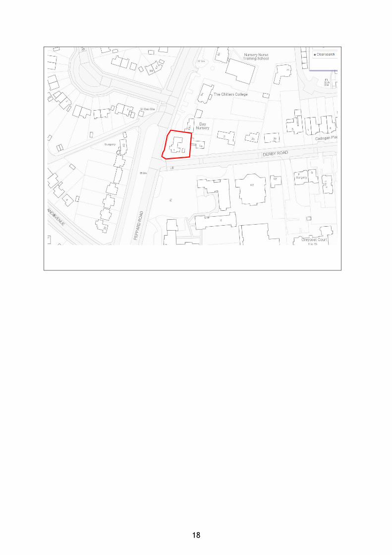
CASE OFFICER: Stephen Vigar METHOD: Written Representation DECISION: DISMISSED DATE DETERMINED: 26.04.2017 WARD: THAMES APPEAL NO: APP/E0345/W/16/3152909 CASE NO: 152208 ADDRESS: 1 Derby Road PROPOSAL: Removal of condition 4 (physiotherapy clinic use operated,
managed or carried out only by person(s) residing in residential part) and variation of condition 5 (Class D1 clinic/consulting room use only) of permission 10/00992/VARIAT to allow wider uses (all medical and health services, education and any necessary office space) at the Class D1 use part of the premises. (resubmission of 151262)
CASE OFFICER: Richard Eatough METHOD: Informal Hearing DECISION: ALLOWED DATE DETERMINED: 27.04.2017 APPLICATION FOR COSTS MADE BY APPLICANT REFUSED
APPENDIX 3 Address Index of Planning Officers reports on appeal decisions. Woodley Arms, Waldeck Street 1 Derby Road, Caversham Planning Officers reports on appeal decisions attached.
13
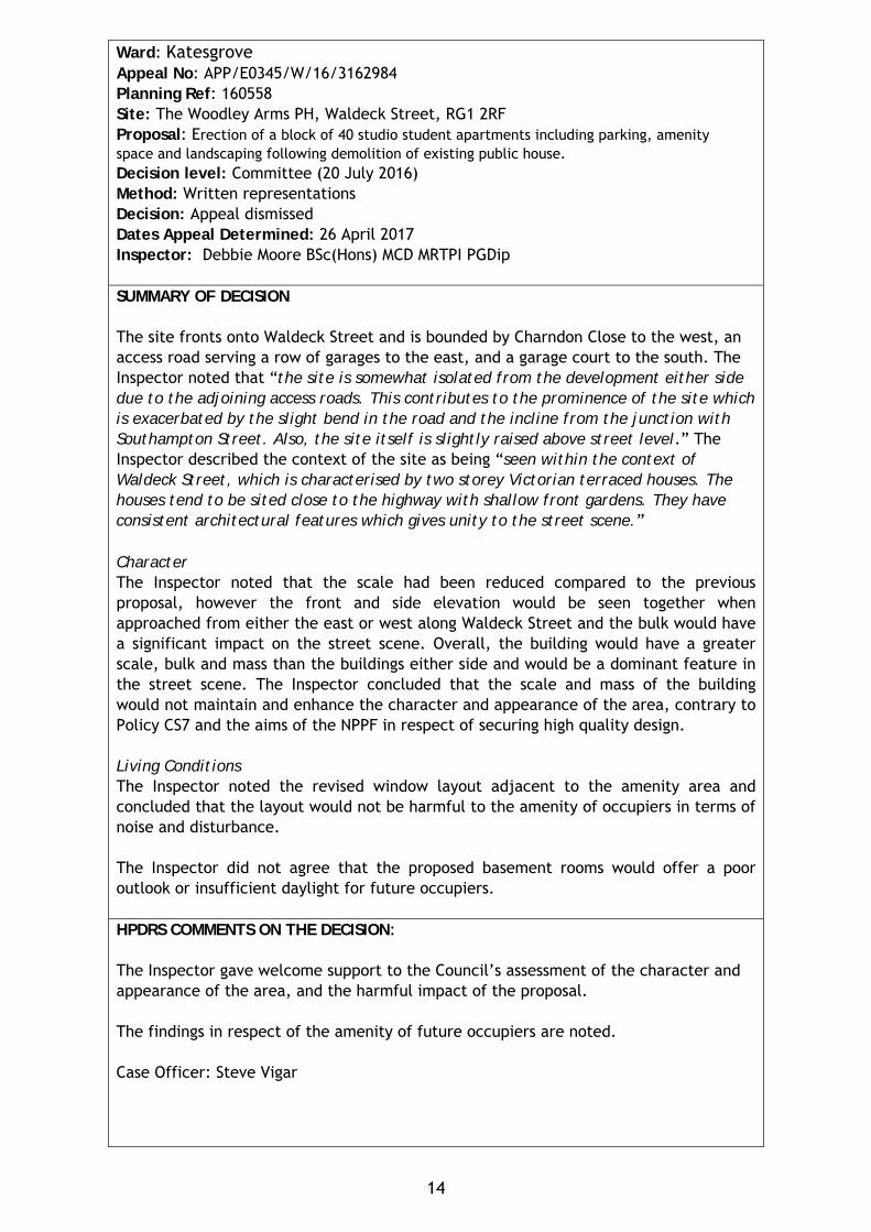
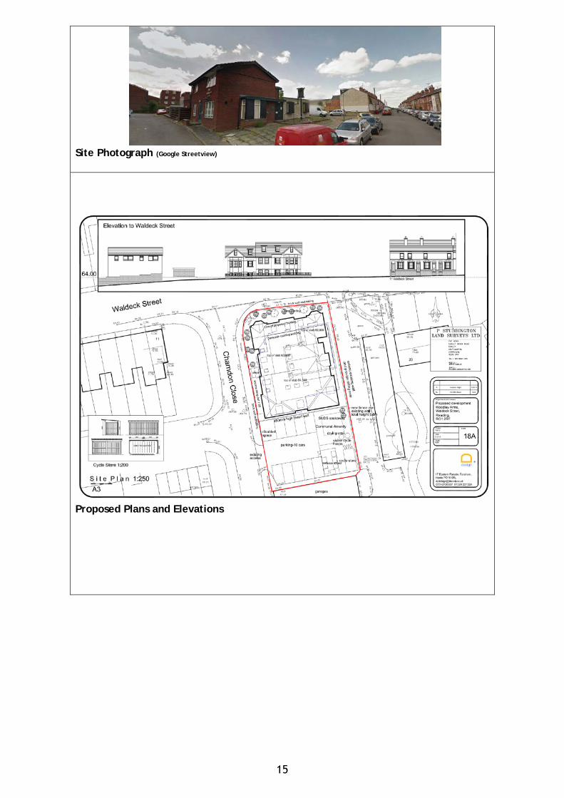
Ward: Katesgrove Appeal No: APP/E0345/W/16/3162984 Planning Ref: 160558 Site: The Woodley Arms PH, Waldeck Street, RG1 2RF Proposal: Erection of a block of 40 studio student apartments including parking, amenity space and landscaping following demolition of existing public house. Decision level: Committee (20 July 2016) Method: Written representations Decision: Appeal dismissed Dates Appeal Determined: 26 April 2017 Inspector: Debbie Moore BSc(Hons) MCD MRTPI PGDip SUMMARY OF DECISION The site fronts onto Waldeck Street and is bounded by Charndon Close to the west, an access road serving a row of garages to the east, and a garage court to the south. The Inspector noted that “the site is somewhat isolated from the development either side due to the adjoining access roads. This contributes to the prominence of the site which is exacerbated by the slight bend in the road and the incline from the junction with Southampton Street. Also, the site itself is slightly raised above street level.” The Inspector described the context of the site as being “seen within the context of Waldeck Street, which is characterised by two storey Victorian terraced houses. The houses tend to be sited close to the highway with shallow front gardens. They have consistent architectural features which gives unity to the street scene.” Character The Inspector noted that the scale had been reduced compared to the previous proposal, however the front and side elevation would be seen together when approached from either the east or west along Waldeck Street and the bulk would have a significant impact on the street scene. Overall, the building would have a greater scale, bulk and mass than the buildings either side and would be a dominant feature in the street scene. The Inspector concluded that the scale and mass of the building would not maintain and enhance the character and appearance of the area, contrary to Policy CS7 and the aims of the NPPF in respect of securing high quality design. Living Conditions The Inspector noted the revised window layout adjacent to the amenity area and concluded that the layout would not be harmful to the amenity of occupiers in terms of noise and disturbance. The Inspector did not agree that the proposed basement rooms would offer a poor outlook or insufficient daylight for future occupiers. HPDRS COMMENTS ON THE DECISION: The Inspector gave welcome support to the Council’s assessment of the character and appearance of the area, and the harmful impact of the proposal. The findings in respect of the amenity of future occupiers are noted. Case Officer: Steve Vigar
14
Site Photograph (Google Streetview)
Proposed Plans and Elevations
15
Ward: Thames Appeal No: APP/E0345/W/16/3152909 Planning Ref: 152208/VARIAT Site: 1 Derby Road, Caversham Proposal: Change of use from residential to physiotherapy clinic and residential without complying with condition 6 of planning permission 94/00488/FD – to removed named users from operating clinic’ without complying with conditions attached to planning permission 10/00992/VARIAT, dated 29 July 2010. Decision level: Delegated Method: Hearing Decision: Appeal allowed (application for award of costs refused) Date Determined: 27 April 2017 Inspector: David Cliff BA Hons MSc MRTPI SUMMARY OF DECISION This was a complicated case. The appeal related to a refused application to vary an existing planning permission where the applicant was attempting to ‘adjust’ an existing mixed-use (sui generis) planning use, in order to provide an unrestricted D1 use to take place. The reasons for refusal of the variation (Section 73) approval were twofold and in summary were:
(1) That this was not lawful under the Planning Acts (this was permitted only as a mixed use and it cannot be turned into something else via a VARIAT application); and
(2) Notwithstanding (1) above, the issues associated with the use being something else within the D1 Use Class (traffic generation, neighbour disturbance, etc.) had not been properly presented.
At the hearing, the Inspector gave consideration to whether it was possible to determine this as a (simple) s.78 appeal, ie. a normal appeal against the refusal of planning permission. However, in the end, the Inspector decided that it was not possible to determine the application as anything other than a variation and his reasoning for this appears at least in part to be in response to officers’ concerns that the views of local residents would not be taken into account. Therefore, he considered the relative merits of what was being asked for in the application. Condition 4 requires an occupancy link between the physiotherapy clinic part of the premises and the residential part (the reason for the condition was to provide adequate parking, turning and manoeuvring space). He found, however, that both uses would remain intrinsically linked and there was no indication that there would be a separation of the planning unit. Therefore, he did not feel that he was able to require that the condition should remain, because any increase in parking requirements arising from the removal of the condition would not be significant and give rise to harm. He therefore found that the condition could be removed because it failed to pass the test of necessity. Condition 5 restricted the use to physiotherapy and residential (the reason is in order that the LPA may properly consider the merits of such an alternative use and control the intensity of use). Again, the Inspector found the condition unnecessary, as a new
16
planning permission would be needed to introduce a further use or uses. As a consequence, the Inspector also removed condition 5. He did not agree with the Council’s concerns for the possible loss of the residential dwelling, because at the hearing, the Appellant confirmed that that was not the intention. Not only was that dwelling still (largely) evident on site at the site visit, but this also lends weight to the continued existence of a mixed use at the site. Head of Planning, Development & Regulatory Services Comment: This is a welcome decision in your officers’ view, as it supports the officer contention that the approach of the applicant was unlawful and the original purpose of the application was to circumvent the proper control of a wider range of D1 uses within this predominantly residential area. To do so would have prejudiced the ability of neighbours to express their views on any such proposals, or for officers to properly evaluate the various impacts which may have arisen. In allowing the appeal, the authorised use of the property remains in the mixed physiotherapy/residential use as approved in 1994; albeit without the previous conditions, which for the reasons above, the Inspector decided were superfluous. Officers are relatively content that the controls afforded by the original planning permission in 1994 (as amended in 2010) are still suitable. Whilst this appeal was in train, a separate application had been submitted to use the premises as part of the adjacent Caversham Preparatory School (ref. 161168). Your meeting on 7 September 2016 resolved to grant planning permission for this change of use, subject to a s106 legal agreement that the residential element be retained in conjunction with the school and for the D1 use to only be operated as part of the Prep School. However, following long delays by the (by then) new owner of the site, planning permission was eventually refused under delegated powers on 6 January 2017, 3 ½ weeks before the hearing took place. The Inspector made it plain in his decision that although technically allowing the appeal, he appreciated that it may not provide the Appellant [or indeed, the owner] with the authorisation sought for a widening of uses, including for an educational use. Accordingly, the use for educational purposes which the Inspector saw on the site visit and which continues, is unauthorised and the new owner has been advised to submit a further application for retrospective planning permission by 6 July 2017; if such is not received by this date, officers will consider the expediency of enforcement action. Regarding the application for costs, whilst the Inspector agreed that officers had taken longer than was necessary to find concerns with the application, he accepted your officers’ assertions that this application was not as simple as was being presented by the applicant/Appellant. He was content that this delay would not have altered the eventual decision in any case,(as the planning merits of the proposal were not acceptable) and he therefore rejected the Appellant’s claim for costs. Case officer: Richard Eatough Site Plan:
17
18
READING BOROUGH COUNCIL
REPORT BY THE DIRECTOR OF ENVIRONMENT & NEIGHBOURHOOD SERVICES TO: PLANNING APPLICATIONS COMMITTEE DATE:
31 May 2017
AGENDA ITEM:
6
TITLE: APPLICATIONS FOR PRIOR APPROVAL
AUTHOR: Lynette Baker
& Julie Williams
JOB TITLE: Area Team Leaders E-MAIL: [email protected] [email protected]
1. PURPOSE AND SUMMARY OF REPORT 1.1 To advise Committee of new applications and decisions relating to applications for
prior-approval under the amended Town and Country Planning (General Permitted Development) Order (GPDO 2015).
2. RECOMMENDED ACTION 2.1 That you note the report. 3. BACKGROUND 3.1 At your meeting on 29 May 2013 a report was presented which introduced new
permitted development rights and additional requirements for prior approval from the local planning authority for certain categories of permitted development. It was agreed then that a report be bought to future meetings for information and to include details of applications received for prior approval, those pending a decision and those applications which have been decided since the last Committee date.
4 TYPES OF PRIOR APPROVAL APPLICATIONS 4.1 The categories of development requiring prior approval under the Town and Country
Planning (General Permitted Development) Order 2015 are summarised as follows:
• Householder development – single storey rear extensions. GPDO Part 1, Class A1(g-k).
• Change of use from A1 shops or A2 financial & professional, betting office, pay day loan shop or casino to A3 restaurants and cafes. GPDO Part 3 Class C.
• Change of use from A1 shops or A2 financial & professional, betting office or pay day loan shop to Class D2 assembly & leisure. GPDO Part 3 Class J.
• Change of use from A1 shops or A2 financial and professional or a mixed use of A1 or A2 with residential to Class C3 residential use. GPDO Part 3 Class M
• Change of use from an amusement arcade or a casino to C3 residential & necessary works. GPDO Part 3 Class N
• Change of use from B1 office to C3 residential. GPDO Part 3, Class O. • Change of use from B8 storage or distribution to C3 residential. GPDO Part 3,
Class P.
19
• Change of use from agricultural buildings and land to Class C3 dwellinghouses and building operations reasonably necessary to convert the building to the C3 use. GPDO Part 3 Class Q.
• Change of use of 150 sq m or more of an agricultural building (and any land within its curtilage) to flexible use within classes A1, A2, A3, B1, B8, C1 and D2. GPDO Part 3 Class R.
• Change of use from Agricultural buildings and land to state funded school or registered nursery D1. GPDO Part 3 Class S.
• Change of use from B1 (business), C1 (hotels), C2 (residential institutions), C2A (secure residential institutions and D2 (assembly and leisure) to state funded school D1. GPDO Part 3 Class T.
• Temporary use of buildings for film making for up to 9 months in any 27 month period. GPDO Part 4 Class E
• Development under local or private Acts and Orders (e.g. Railways Clauses Consolidation Act 1845). GPDO Part 18.
• Development by telecommunications code system operators. GPDO Part 16. • Demolition of buildings. GPDO Part 11.
4.2 Those applications for Prior Approval received and yet to be decided are set out in the appended Table 1 and those applications which have been decided are set out in the appended Table 2. The applications are grouped by type of prior approval application. Information on what the estimated equivalent planning application fees would be is provided.
4.3 It should be borne in mind that the planning considerations to be taken into account
in deciding each of these types of application are specified in more detail in the GDPO. In some cases the LPA will first need to confirm whether or not prior approval is required before going on to decide the application on its planning merits where prior approval is required.
4.4 Details of any appeals on prior-approval decision will be included elsewhere in the
agenda. 5. CONTRIBUTION TO STRATEGIC AIMS 5.1 Changes of use brought about through the prior approval process are beyond the
control or influence of the Council’s adopted policies and Supplementary Planning Documents. Therefore it is not possible to confirm how or if these schemes will contribute to the strategic aims of the Council.
6. COMMUNITY ENGAGEMENT AND INFORMATION 6.1 Statutory consultation takes place in connection with applications for prior-approval
as specified in the Order discussed above. 7 EQUALITY IMPACT ASSESSMENT 7.1 Where appropriate the Council must have regard to its duties under the Equality Act
2010, Section 149, to have due regard to the need to— • eliminate discrimination, harassment, victimisation and any other conduct that is
prohibited by or under this Act; • advance equality of opportunity between persons who share a relevant protected
characteristic and persons who do not share it; • foster good relations between persons who share a relevant protected
characteristic and persons who do not share it. 7.2 There are no direct implications arising from the proposals.
20
8. LEGAL IMPLICATIONS 8.1 None arising from this Report. 9. FINANCIAL IMPLICATIONS 9.1 Since the additional prior notifications were introduced in May 2013 in place of
applications for full planning permission, the loss in fee income is estimated to be £786,777
(Office Prior Approvals - £725,561: Householder Prior Approvals - £49,536:
Retail Prior Approvals - £4200: Demolition Prior Approval - £2135: Storage Prior Approvals - £5045: Shop to Restaurant Prior Approval - £300) Figures since last report Office Prior Approvals - £31484: Householder Prior Approvals - £1548
9.2 However it should be borne in mind that the prior notification application assessment process is simpler than would have been the case for full planning permission and the cost to the Council of determining applications for prior approval is therefore proportionately lower. It should also be noted that the fee for full planning applications varies by type and scale of development and does not necessarily equate to the cost of determining them.
10. BACKGROUND PAPERS The Town and Country Planning (General Permitted Development) (England) Order
2015.
21
Table 1 – Prior-approval applications pending @ 16 May 2017 Application type CLASS A - Householder Application type
Application reference number
Address Ward Proposal Date Received
Target Determination Date
Comments Equivalent planning application fee
Householder Prior Approval - Class A, Part 1 GPDO 2015
170604 13 Salcombe Road, Reading, RG2 7LH
Church Rear extension measuring 6m in depth, with a maximum height of 3m, and 2.95m in height to eaves level.
13/04/2017 30/05/2017 £172
Householder Prior Approval - Class A, Part 1 GPDO 2015
170612 14 Rydal Avenue, Tilehurst, Reading, RG30 6XT
Kentwood Rear extension measuring 5.5m in depth, with a maximum height of 3.95m and 2.5m in height to eaves level.
18/04/2017 04/06/2017 £172
Householder Prior Approval - Class A, Part 1 GPDO 2015
170659 24 Stone Street, Reading, RG30 1HU
Kentwood Rear extension measuring 5m in depth, with a maximum height of 3.25m, and 2.8m in height to eaves level.
25/04/2017 08/06/2017 £172
Householder Prior Approval - Class A, Part 1 GPDO 2015
170675 18 Swansea Road, Reading, RG1 8EY
Abbey Rear extension measuring 6m in depth, with a maximum height of 2.6m, and 2.3m in height to eaves level.
27/04/2017 07/06/2017 £172
22
Application type
Application reference number
Address Ward Proposal Date Received
Target Determination Date
Comments Equivalent planning application fee
Householder Prior Approval - Class A, Part 1 GPDO 2015
170693 80 Ashampstead Road, Reading, RG30 3LG
Southcote Rear extension measuring 5 metres in depth, with a maximum height of 4 metres and 2.2 metres in height to eaves level.
02/05/2017 22/06/2017 £172
Householder Prior Approval - Class A, Part 1 GPDO 2015
170709 32 Ripley Road, Tilehurst, Reading, RG30 6UD
Kentwood Rear extension measuring 4m in depth, with a maximum height of 3.31m, and 3.29m in height to eaves level.
04/05/2017 20/06/2017 £172
Householder Prior Approval - Class A, Part 1 GPDO 2015
170748 104 Water Road, Reading, RG30 2NN
Norcot Rear extension measuring 5m in depth, with a maximum height of 3m, and 2.8m in height to eaves level.
10/05/2017 20/06/2017 £172
Householder Prior Approval - Class A, Part 1 GPDO 2015
170749 27 North Street, Caversham, Reading, RG4 8JA
Caversham Rear extension measuring 6m in depth, with a maximum height of 2.65m, and 2.35m in height to eaves level.
27/04/2017 07/06/2017 £172
Householder Prior Approval - Class A, Part 1 GPDO 2015
170754 79 Gosbrook Road, Caversham, Reading, RG4 8BN
Caversham Rear extension measuring 3.73m in depth, with a maximum height of 3.41m, and 3.0m in height to eaves level.
12/05/2017 22/06/2017 £172
Office to Residential Prior Approval applications pending 23
Application type
Application reference number
Address Ward Proposal Date Received
Target Determination Date
Comments Equivalent planning application fee
Office use to dwelling house - Class O, Part 1 GPDO 2015
170498 22-24 Cross Street, Reading
Abbey Change of use of first, second and third floor from Class B1(a) (offices) to C3 (dwelling houses) to comprise 3 x 1-bed flats and 6 x studios.
28/03/2017 23/05/2017 £3000
Office use to dwelling house - Class O, Part 1 GPDO 2015
170512 Aspen House, 300 Kings Road, Reading, RG1 4HP
Redlands Change of use of office building from Class B1(a) (offices) to C3 (dwelling houses) to comprise 78 flats.
30/03/2017 25/05/2017 £29334
Office use to dwelling house - Class O, Part 1 GPDO 2015
170555 130 Queens Road, Reading, RG1 4DG
Abbey Change of use from Class B1 (a) (offices) to C3 (dwelling houses) to comprise five flats (3 x 2 bed flats, 1 x 1 bed flat and 1 x studio).
05/04/2017 31/05/2017 £1460
Office use to dwelling house - Class O, Part 1 GPDO 2015
170714 78 London Street, Reading
Katesgrove Change of use of basement, ground, first, second and third floors from Class B1(a) (offices) to C3 (dwelling houses) to comprise 2 no. 1 bed and 1 no. 2 bed flats.
05/05/2017 30/06/2017 £690
Telecommunications Prior Approval applications pending
24
Application type
Application reference number
Address Ward Proposal Date Received
Target Determination Date
Comments
Telecommunications Notification - Prior Approval
170553 Pavement opposite 121, Kings Road, Reading
Redlands Prior approval for removal of existing 14.4m lamppost monopole and erection of 15m Alpha monopole, installation of 1 no. proposed equipment cabinet plus ancillary apparatus
04/04/2017 30/05/2017
Telecommunications Notification - Prior Approval
170554 Lampost opposite Buckingham Drive Service Station, Buckingham Drive, Emmer Green, Reading, RG4 8RZ
Peppard Prior Approval for replacement of existing 12.5m monopole with a 13m phase 4 monopole and 1 no. equipment cabinet
04/04/2017 30/05/2017
Retail Prior Approvals applications pending Application type
Application reference number
Address Ward Proposal Date Received
Target Determination Date
Comments Equivalent planning application fee
Retail Prior Approval
170619 4a Bridge Street, Caversham, Reading, RG4 8AA
Caversham Change of use of ground floor from Class A2 (financial and professional services) to C3 (dwellinghouses) to comprise 1 x 1 bed flat.
18/04/2017 13/06/2017 £300
Shop to Restaurant Prior Approval applications pending 25
Application type
Application reference number
Address Ward Proposal Date Received
Target Determination Date
Comments Equivalent planning application fee
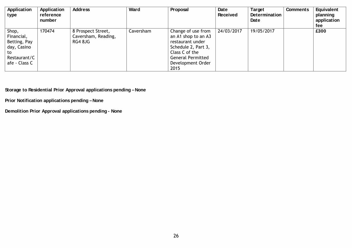
Shop, Financial, Betting, Pay day, Casino to Restaurant/Cafe - Class C
170474 8 Prospect Street, Caversham, Reading, RG4 8JG
Caversham Change of use from an A1 shop to an A3 restaurant under Schedule 2, Part 3, Class C of the General Permitted Development Order 2015
24/03/2017 19/05/2017 £300
Storage to Residential Prior Approval applications pending – None Prior Notification applications pending – None Demolition Prior Approval applications pending - None
26
Table 2 – Prior-approval applications decided 12 April 2017 to 16 May 2017
Application type CLASS A – Householder
Application type
Application reference number
Address Ward Proposal Date Received
Decision Date
Decision
Householder Prior Approval - Class A, Part 1 GPDO 2015
170404 Felix Cottages, Kiln Road, Emmer Green, Reading
Peppard Rear extension measuring 4.12m in depth, with a maximum height of 3.84m, and 2.7m in height to eaves level.
14/03/2017 24/04/2017 Application Permitted
Householder Prior Approval - Class A, Part 1 GPDO 2015
170472 72 Northumberland Avenue, Reading, RG2 7PP
Katesgrove Rear extension measuring 6.0m in depth, with a maximum height of 3.2m, and 3m in height to eaves level.
24/03/2017 27/04/2017 Prior Approval NOT REQUIRED
Householder Prior Approval - Class A, Part 1 GPDO 2015
170479 80 Combe Road, Tilehurst, Reading, RG30 4NE
Tilehurst Rear extension measuring 3.5m in depth, with a maximum height of 2.820m, and 2.450m in height to eaves level.
27/03/2017 05/05/2017 Prior Approval NOT REQUIRED
Householder Prior Approval - Class A, Part 1 GPDO 2015
170510 5 Northcourt Avenue, Reading, RG2 7HE
Church Rear extension measuring 6m in depth, with a maximum height of 3.89m, and 3m in height to eaves level.
30/03/2017 03/05/2017 Prior Approval NOT REQUIRED
27
Application type
Application reference number
Address Ward Proposal Date Received
Decision Date
Decision
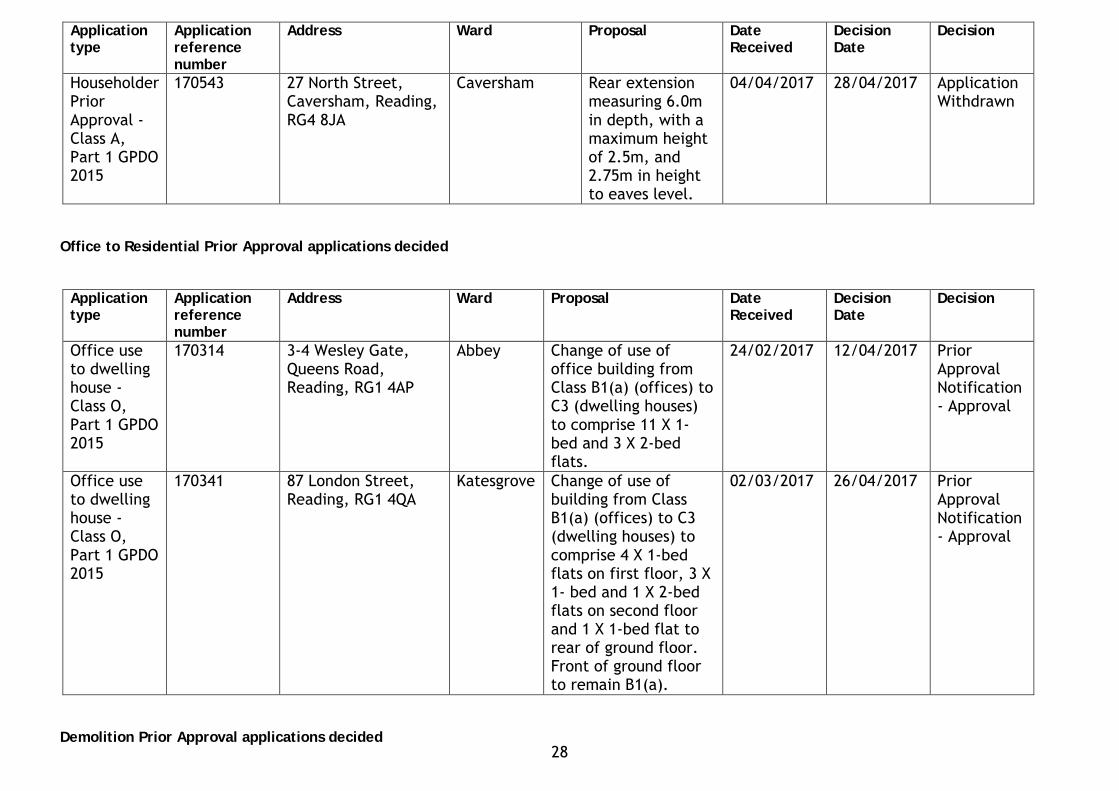
Householder Prior Approval - Class A, Part 1 GPDO 2015
170543 27 North Street, Caversham, Reading, RG4 8JA
Caversham Rear extension measuring 6.0m in depth, with a maximum height of 2.5m, and 2.75m in height to eaves level.
04/04/2017 28/04/2017 Application Withdrawn
Office to Residential Prior Approval applications decided
Application type
Application reference number
Address Ward Proposal Date Received
Decision Date
Decision
Office use to dwelling house - Class O, Part 1 GPDO 2015
170314 3-4 Wesley Gate, Queens Road, Reading, RG1 4AP
Abbey Change of use of office building from Class B1(a) (offices) to C3 (dwelling houses) to comprise 11 X 1-bed and 3 X 2-bed flats.
24/02/2017 12/04/2017 Prior Approval Notification - Approval
Office use to dwelling house - Class O, Part 1 GPDO 2015
170341 87 London Street, Reading, RG1 4QA
Katesgrove Change of use of building from Class B1(a) (offices) to C3 (dwelling houses) to comprise 4 X 1-bed flats on first floor, 3 X 1- bed and 1 X 2-bed flats on second floor and 1 X 1-bed flat to rear of ground floor. Front of ground floor to remain B1(a).
02/03/2017 26/04/2017 Prior Approval Notification - Approval
Demolition Prior Approval applications decided 28
Application type
Application reference number
Address Ward Proposal Date Received
Decision Date
Decision
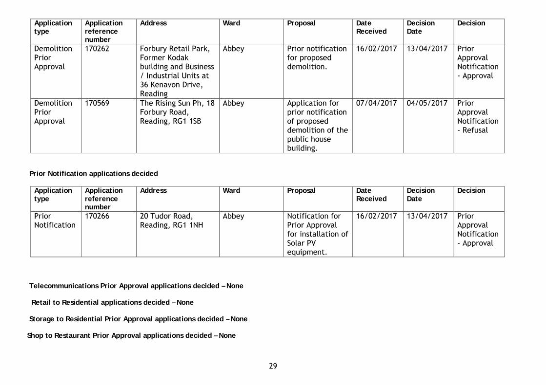
Demolition Prior Approval
170262 Forbury Retail Park, Former Kodak building and Business / Industrial Units at 36 Kenavon Drive, Reading
Abbey Prior notification for proposed demolition.
16/02/2017 13/04/2017 Prior Approval Notification - Approval
Demolition Prior Approval
170569 The Rising Sun Ph, 18 Forbury Road, Reading, RG1 1SB
Abbey Application for prior notification of proposed demolition of the public house building.
07/04/2017 04/05/2017 Prior Approval Notification - Refusal
Prior Notification applications decided
Application type
Application reference number
Address Ward Proposal Date Received
Decision Date
Decision
Prior Notification
170266 20 Tudor Road, Reading, RG1 1NH
Abbey Notification for Prior Approval for installation of Solar PV equipment.
16/02/2017 13/04/2017 Prior Approval Notification - Approval
Telecommunications Prior Approval applications decided – None Retail to Residential applications decided – None Storage to Residential Prior Approval applications decided – None Shop to Restaurant Prior Approval applications decided – None
29
READING BOROUGH COUNCIL
REPORT BY DIRECTOR OF ENVIRONMENT, CULTURE & SPORT TO: PLANNING APPLICATIONS COMMITTEE
DATE: 31st May 2017 AGENDA ITEM: 7 TITLE:
QUARTERLY PERFORMANCE MONITORING REPORT – DEVELOPMENT MANAGEMENT SERVICE – Quarter 4 2016/17
SERVICE: PLANNING
WARDS: BOROUGHWIDE
LEAD OFFICER: KIARAN ROUGHAN
TEL: 0118 937 4530 (74530)
JOB TITLE: PLANNING MANAGER
E-MAIL: [email protected]
1. PURPOSE AND SUMMARY OF REPORT 1.1 This report provides quarterly reports for Quarter4 of 2016/17 (Jan-March 2017). The
report indicates this Council’s current performance against government criteria for designation and corporate indicators where they vary from the government criteria.
2. RECOMMENDED ACTION 2.1 The contents of the report be noted. 3. BACKGROUND 3.1 Members will recall that at the end of 2016, the Secretary of State introduced new
criteria for making or revoking a designation in respect of a local planning authority’s performance in determining planning applications. The main measure to be used is the percentage of decisions on applications made:
(a) within the statutory determination period; or (b) within such extended period as has been agreed in writing between the applicant
and the local planning authority; These measures are applied separately to major applications and to non-major applications. There are also quality measures that relate to appeal decisions which are reported in the Annual Monitoring Report.
Performance indicators and targets 4.1 The following table provides monitoring information against the relevant quarterly
corporate indicators. These include the new government criteria:
30
Table 1 RBC Planning Service Quarterly Performance Indicators for Q4 2015/16
Description Target 14 -15 15-16
Q1 16-17
Q2
16-17
Q3
16-17
Q4
16-17
Percentage of major applications decided within: (i) statutory 13/16 weeks, or (ii) the extended period
agreed with the applicant. (NB note that a risk of designation occurs where 40% or fewer of their decisions on major applications are made within the statutory determination period or such extended period as has been agreed in writing with the applicant).
60% 64% 85% (17/20)
100% (7/7)
92% (12/13)
87.5% (14/16)
100% (11/11)
Percentage of minor applications decided within
(i) statutory 8 weeks or (ii) the extended period
agreed by the applicant.
65% 6% 71% (143/201)
77%
(37/48)
71%
(45/63)
84% (49/58)
87% (47/54)
Percentage of other applications decided within statutory 8 weeks
80% 62%
54% (366/676
56%
(116/209
57%
(113/197
65%
(124/192)
61%
(104/171)
Percentage of other applications decided within (i) statutory 8 weeks or (ii) the extended period as agreed by applicant.
80% 77%
73%
(493/676)
85%
(177/209
87%
(171/197
84% (162/192)
86%
(147/171)
Percentage of householder applications (not for prior approval) decided within (i) statutory 8 weeks or (ii) the extended period agreed by the applicant.
80% 81% 75% (342/457)
87%
(116/134
88%
(116/131
85% (100/118)
84%
(98/116)
Percentage of householder applications (not for prior approval) decided within statutory 8 weeks.
80% 67% 55% (249/456)
59% (79/134)
59% (78/131)
67% (79/118)
62% (72/116)
Planning Enforcement: % of enforcement complaints resolved within appropriate deadline according to priority
60% 52% 66% (178/269)
87% (60/69)
73% (61/83)
92% (60/65)
77%
(63/82)
Appeal performance - % allowed as a total of all appeals (a lower % figure is better)
30% 26% 27% (9/33)
50% (3/6)
14% (1/7)
0% (0/9)
21% (4/19)
Major application appeal performance - % allowed as a total of all appeals (NB note that a risk of designation occurs where more than 20% of major applications decisions are overturned on appeal. (a lower % figure is better)
20% 0% 0% (0/0)
0% (0/0)
0% (0/0)
0% (0/0)
0% (0/0)
Comments on planning application performance and workload 4.4 Key results for the second and third quarters of 2016/17 are as follows:
• The Council’s performance on major applications at 100% remains well above the target level.
31
• The performance on “Minor” applications (applications for 1-10 dwellings and 100-1000m2 floorspace for non-residential applications) has improved slightly but is also well above target.
• Performance on all “Other” applications, including householder applications, has
also has improved slightly remaining well above target levels when extensions of time are taken into account.
• Enforcement performance in the 4th Quarter remains well above target;
• Appeal decisions remain well below the target of 30% being allowed.
5. CONTRIBUTION TO STRATEGIC AIMS 5.1 Planning services contribute to producing a sustainable environment and economy
within the Borough and to meeting the 2016 - 19 Corporate Plan objective for “Keeping the town clean, safe, green and active.” Under the heading, Neighbourhoods, the Corporate Plan aims to improve the physical environment – the cleanliness of our streets, places for children to play, green spaces, how we feel about our neighbourhood and whether we feel safe, have a sense of community and get on with our neighbours.
6. COMMUNITY ENGAGEMENT AND INFORMATION 6.1 Statutory consultation takes place on planning applications and appeals and this can
influence the speed with which applications and appeals are decided. Information on development management performance is publicly available.
7. EQUALITY IMPACT ASSESSMENT 7.1 Under the Equality Act 2010, Section 149, a public authority must, in the exercise of its
functions, have due regard to the need to:
• eliminate discrimination, harassment, victimisation and any other conduct that is prohibited by or under this Act;
• advance equality of opportunity between persons who share a relevant protected characteristic and persons who do not share it;
• foster good relations between persons who share a relevant protected characteristic and persons who do not share it.
7.2 In terms of the key equalities protected characteristics, it is considered that the
development management performance set out in this report has no adverse impacts. 8. LEGAL IMPLICATIONS 8.1 The collection and monitoring of performance indicators is a statutory requirement and a
requirement of DCLG. In addition a number of the work related programmes referred to in this report are mandatory requirements including the determination of planning applications and the preparation of the development plan.
9. FINANCIAL IMPLICATIONS 9.1 There are no direct financial implications arising from this report.
32
READING BOROUGH COUNCIL
REPORT BY DIRECTOR OF ENVIRONMENT, CULTURE & SPORT TO: PLANNING APPLICATIONS COMMITTEE
DATE: 31st May 2017 AGENDA ITEM: 8 TITLE:
ANNUAL PERFORMANCE MONITORING REPORT – DEVELOPMENT MANAGEMENT SERVICE - 2016/17
SERVICE: PLANNING
WARDS: BOROUGHWIDE
LEAD OFFICER: KIARAN ROUGHAN
TEL: 0118 937 4530 (74530)
JOB TITLE: PLANNING MANAGER
E-MAIL: [email protected]
1. PURPOSE AND SUMMARY OF REPORT 1.1 To provide details of performance in development management (applications, appeals,
enforcement and associated services) during 2016/17. 2. RECOMMENDED ACTION 2.1 That the contents of the report be noted. 3. BACKGROUND 3.1 This report provides information on the performance of the Planning Service for the year
2016/17 as a whole. Short reports on quarterly performance are also presented to Committee throughout the year.
4. PLANNING APPLICATION PERFORMANCE Performance indicators and targets 4.1 Statutory time targets provide time periods within which planning authorities should decide
planning applications. The 2016/17 corporate performance indicators set uses a number of DCLG indicators which are based on these statutory time targets.
4.2 The determination of planning applications is monitored in relation to the statutory target
timescales, i.e.
• 60% of “Major” applications to be determined in 13 weeks (note that where an application is subject to an Environmental Impact Assessment, a 16 week limit applies);
• 65% of “Minor” applications to be determined in 8 weeks; and • 80% of “Other” applications to be determined in 8 weeks.
Since 2011, the government has allowed local authorities to agree Planning Performance Agreements (PPA) or simple extensions of time with applicants for major applications. These allow the above statutory targets to be set aside (see relevant National Planning Policy Guidance). New Indicators introduced in 2017 allow for all applications to be accompanied by a PPA or an extension of time to meet the target regardless of the time taken. For consistency, and as PPA’s and extensions of time can be agreed for any application, the same
33
indicator is now used in respect of Minor applications and Other categories including householder applications.
4.3 Since 2011, the Government has operated the Planning Guarantee. This is intended to give a
clear time limit within which all planning applications should be decided including where an appeal has been made. The Guarantee is that, in principle, no application should spend more than 26 weeks with either the LPA or the Planning Inspectorate. As a development of the Planning Guarantee the government has set criteria against which it will designate local planning authorities. Designation would mean that certain applications can be made directly to the Secretary of State for determination. There criteria were extended during 2016. The changes are set out in the DCLG document “Improving and for the 2017 threshold and assessment period involve the following measures:
(i) the speed with which the authority deals with major applications; (ii) the speed with which the authority deals with non-major applications;
The previous measure of the extent to which decisions on major applications are overturned at appeal will not be assessed for the 2017 assessment. However for 2018, the assessment will include this measure for both major and non-major applications.
4.4 The thresholds for 2017 for (i) is now 50% or fewer of major applications determined within 13
weeks over the 2 year period October 2014 to September 2016 (but excluding PPA applications and those where the applicant has agreed an extension of time with the LPA). For (ii), the threshold is 65% over the same 2 year period. As reported to Planning Applications Committee in January 2017 (Quarterly Performance Report), our calculations show that these thresholds have been met comfortably. As can be seen from the reports on performance below, the Council’s performance is significantly above the thresholds.
4.5 It is important to ensure that prior approval applications are decided within the prescribed 42
or 56 days otherwise prior approval is given by default. This indicator is reported in Table 2 below.
Table 1. RBC Performance Indicators 2015/16 for the Planning Service.
Description Frequency Target 14 -15 15-16 16-17
Percentage of major applications decided within: (i) statutory 13/16 weeks, or (ii) the extended period
agreed with the applicant. (NB note that a risk of designation occurs where 40% or fewer of their decisions on major applications are made within the statutory determination period or such extended period as has been agreed in writing with the applicant).
Q 60% 64% 85% (17/20)
89% (42/47)
Percentage of minor applications decided within
(i) statutory 8 weeks or (ii) the extended period
agreed by the applicant.
Q 65% 66%
71% (143/201)
74%
(166/223)
Percentage of other applications decided within statutory 8 weeks
Q 80% 62%
54% (366/676)
59%
(457/769)
34
Description Frequency Target 14 -15 15-16 16-17
Percentage of other applications decided within (i) statutory 8 weeks or (ii) the extended period as agreed by applicant.
Q 80% 77%
73% (493/676)
85% (657/769)
Percentage of householder applications (not for prior approval) decided within statutory 8 weeks.
Q 80% 67% 55% (249/456)
62% (308/499)
Percentage of householder applications (not for prior approval) decided within (i) statutory 8 weeks or (ii) the extended period agreed by the applicant.
Q 80% 81% 75% (342/457)
86% (430/499)
Planning Enforcement: % of enforcement complaints resolved within the relevant Enforcement Plan target period from the date of receipt.
Q 60% 52% 66% (178/269)
82% (244/299)
Appeal performance - % allowed as a total of all appeals (a lower % figure is better)
Annual 30% 26%
27% (9/33)
20%
(8/41) Major application appeal performance - % allowed as a total of all appeals (NB note that a risk of designation occurs where more than 20% of major applications decisions are overturned on appeal. (a lower % figure is better)
Annual 20% 0% 0% (0/0)
0% (0/0)
4.7 Table 2 below sets out performance by application type and indicator for those DCLG indicators
that are not covered in the RBC Performance Indicators 2015/16 for the Planning Service.
TABLE 2 Other DCLG Planning Application Performance Measures
Indicator
Target 2013-14 2014-15 2015-16 2016-17
Percentage of MAJOR applications decided within statutory 13/16 weeks.
60% 50% 28% 47% 28% (13/47)
Percentage of MINOR applications decided within statutory 8 wks.
65% 61.5% 43% 53% 41% (92/225)
Percentage of ALL applications decided within (i) 26 weeks or (ii) extended period agreed by applicant
100% 79.2% 97.8% 87%
93% (973/1041)
Percentage of applications for PRIOR APPROVAL decided within the statutory period (42 or 56 days).
100% 100% 100% 97% 96% (128/133)
35
4.9 The total number of decisions by different application types is shown in Table 3 and is compared to previous years. As can be seen the number of applications decided in 2016/17 fell compared to 2015/16 albeit only slightly below the level decided in 2014/15.
TABLE 3: Number of decisions made annually by application type since 2013/14
Major
Minor
Other
Total
House-holder Prior-
approv.
Office to Res. Prior
approv.
Grand Total
2013/14
18
139
651
808
46
35
889
2014/15
36
201
692
929
60
52
1041
2015/16 (% change compared to 2014/15)
25 (-31%)
219 (+9%)
872 (+26%)
1116 (+20%)
85 (+42%)
36 (-31%)
1237 (+19%)
2016/17 (% change compared to 2015/16)
48 (+92%)
227 (+4%)
615 (-29%)
890 (-20%)
94 (+11%)
24 (-33%)
1008 (-19%)
Interestingly the number of decisions on major applications increased significantly, and on minors there was a small increase. It was the Other category, which includes householder applications, that saw a significant fall but again only back to the levels of earlier years. Householder prior approvals which relate to smaller house extensions did however increase. The number of office to residential prior approvals fell quite significantly.
4.10 The following chart shows the overall number of valid applications received since 2013/14
including prior approvals and householder applications:
0
50
100
150
200
250
300
350
400
450
Q113-14
Q213-14
Q313-14
Q413-14
Q114-15
Q214-15
Q314-15
Q414-15
Q115-16
Q215-16
Q315-16
Q415-16
Q116-17
Q216-17
Q316-17
Q416-17
Number of validated applications
36
Although figures vary between quarters, the number of validated applications rose in 2016/17 compared to 2015/16 (a total of 1395 compared to a total of 1345 in 2015/16). However, as can be seen, numbers fell back somewhat in the second part of the year. Again, this is mainly because applications in the Other category, including householder applications, and Prior Approvals, have fallen back.
A total of 128 prior approval applications were validated in 2017/17, compared to 152 in 2015/16 although Office to Residential prior approvals have slowed significantly compared to 2015/16.
Planning applications performance 2015/16
• 88.6% of all applications were granted permission.
• Performance in relation to determining Major applications has improved slightly during 2016/17 compared to the performance during 2015/16, with extensions of time are being sought more systematically for applications that go over the 13 week target. The numbers being determined within 13 weeks have however fallen, partly reflecting the complexity of many of the major applications determined during the year.
• Performance on Minor applications is slightly above the performance in 2015/16, again
because extensions of times are being sought more systematically. However, as indicated in TABLE 2, the determination of applications within 8 week target has fallen. These applications continue to be affected by the change in government policy on seeking affordable housing on small site of 10 or less dwellings.
• Performance on Other applications including householder applications has improved in
percentage terms for applications with extensions of time but did fall back in terms of the target 8 weeks.
• Enforcement performance shows a significant improvement compared to previous years
• There remains some room for improvement in performance in terms of meeting
statutory target timescales albeit that performance against timescales agreed with the applicant through extensions of time is now very satisfactory.
Other Development Management Applications 4.12 The Council also receives requests for pre-application advice, for approval of details required
by or discharge of conditions attached to planning permissions and for approval of works to trees covered by Tree Preservation Orders and in trees in Conservation Areas. Table 5 shows the number of each type of application received since 2013/14.
TABLE 4: No. of applications received for miscellaneous development management advice or approval.
2013/14
2014/15
2015/16
2016/17
Pre-application advice 177
209
219 (+5%) 198 (-10%)
Approval of details required by condition,
ADJ LPA, NMA, EIA SCO and SCR.
283 313
355 (+13%)
388 (+9%)
37
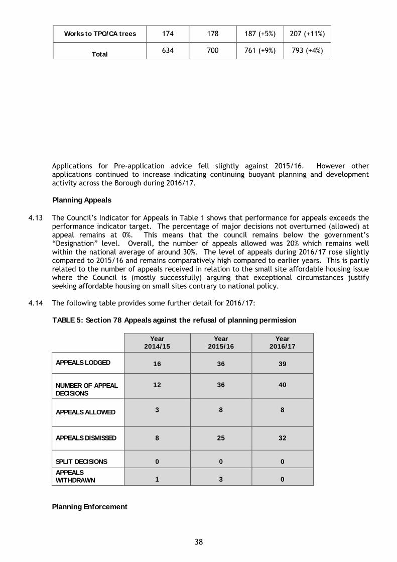
Applications for Pre-application advice fell slightly against 2015/16. However other applications continued to increase indicating continuing buoyant planning and development activity across the Borough during 2016/17.
Planning Appeals 4.13 The Council’s Indicator for Appeals in Table 1 shows that performance for appeals exceeds the
performance indicator target. The percentage of major decisions not overturned (allowed) at appeal remains at 0%. This means that the council remains below the government’s “Designation” level. Overall, the number of appeals allowed was 20% which remains well within the national average of around 30%. The level of appeals during 2016/17 rose slightly compared to 2015/16 and remains comparatively high compared to earlier years. This is partly related to the number of appeals received in relation to the small site affordable housing issue where the Council is (mostly successfully) arguing that exceptional circumstances justify seeking affordable housing on small sites contrary to national policy.
4.14 The following table provides some further detail for 2016/17: TABLE 5: Section 78 Appeals against the refusal of planning permission
Year 2014/15
Year 2015/16
Year 2016/17
APPEALS LODGED
16
36
39
NUMBER OF APPEAL DECISIONS
12
36
40
APPEALS ALLOWED 3
8
8
APPEALS DISMISSED
8
25
32
SPLIT DECISIONS
0
0
0
APPEALS WITHDRAWN
1
3
0
Planning Enforcement
Works to TPO/CA trees 174 178 187 (+5%) 207 (+11%)
Total 634 700 761 (+9%) 793 (+4%)
38
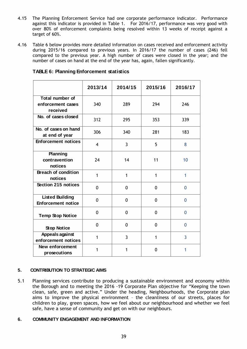
4.15 The Planning Enforcement Service had one corporate performance indicator. Performance against this indicator is provided in Table 1. For 2016/17, performance was very good with over 80% of enforcement complaints being resolved within 13 weeks of receipt against a target of 60%.
4.16 Table 6 below provides more detailed information on cases received and enforcement activity
during 2015/16 compared to previous years. In 2016/17 the number of cases (246) fell compared to the previous year. A high number of cases were closed in the year; and the number of cases on hand at the end of the year has, again, fallen significantly. TABLE 6: Planning Enforcement statistics
2013/14 2014/15 2015/16 2016/17
Total number of enforcement cases
received 340 289 294 246
No. of cases closed
312 295 353 339
No. of cases on hand at end of year
306 340 281 183
Enforcement notices
4 3 5 8
Planning contravention
notices 24 14 11 10
Breach of condition notices
1 1 1 1
Section 215 notices
0 0 0 0
Listed Building Enforcement notice
0 0 0 0
Temp Stop Notice
0 0 0 0
Stop Notice
0 0 0 0
Appeals against enforcement notices
1 3 1 3
New enforcement prosecutions
1 1 0 1
5. CONTRIBUTION TO STRATEGIC AIMS 5.1 Planning services contribute to producing a sustainable environment and economy within
the Borough and to meeting the 2016 -19 Corporate Plan objective for “Keeping the town clean, safe, green and active.” Under the heading, Neighbourhoods, the Corporate plan aims to improve the physical environment – the cleanliness of our streets, places for children to play, green spaces, how we feel about our neighbourhood and whether we feel safe, have a sense of community and get on with our neighbours.
6. COMMUNITY ENGAGEMENT AND INFORMATION
39
6.1 Statutory consultation takes place on planning applications and appeals and this can influence the speed with which applications and appeals are decided. Information on development management performance is publicly available.
7. EQUALITY IMPACT ASSESSMENT 7.1 Under the Equality Act 2010, Section 149, a public authority must, in the exercise of its
functions, have due regard to the need to:
• eliminate discrimination, harassment, victimisation and any other conduct that is prohibited by or under this Act;
• advance equality of opportunity between persons who share a relevant protected characteristic and persons who do not share it;
• foster good relations between persons who share a relevant protected characteristic and persons who do not share it.
7.2 In terms of the key equalities protected characteristics, it is considered that the development
management performance set out in this report has no adverse impacts. 8. LEGAL IMPLICATIONS 8.1 The collection and monitoring of performance indicators is a statutory requirement and a
requirement of DCLG. In addition a number of the work related programmes referred to in this report are mandatory requirements including the determination of planning applications and the preparation of the development plan.
9. FINANCIAL IMPLICATIONS 9.1 There are no direct financial implications arising from this report. Specific initiatives referred to will be met from existing budgets.
40

ABBEY
41

42
COMMITTEE REPORT
BY THE DIRECTOR OF ENVIRONMENT AND NEIGHBOURHOOD SERVICES
READING BOROUGH COUNCIL ITEM NO. 9
PLANNING APPLICATIONS COMMITTEE: 31st May 2017
Ward: Abbey
App No.: 170359 LBC and 170360 ADV
Address: 3-5 King Street, Reading
Proposal: Consent for location of external advert and lanterns and hanging sign on
rear elevation
Applicant: New World Trading Company (UK) Ltd
Date valid: 08/03/2017
8-week target decision date: 03/05/2017
26-Week date: 06/09/2017
RECOMMENDATION :
Is to APPROVE Listed Building Consent 170359/LBC with the following conditions:
1. LBC Time 2. Details of Resin method 3. Schedule of Repairs 4. Illumination
INFORMATIVES TO INCLUDE:
1. Approved plans. Canopies and structures overhanging the highway 2. No other works approved 3. Terms and conditions of this consent
Is to APPROVE Advertisement Consent 170360/ADV with the following conditions
1. Plans approved, including fixing details 2. Illumination 3. Standard advertisement conditions
INFORMATIVES TO INCLUDE:
1. Terms and conditions of this consent 2. No other signage approved by this consent 3. Positive and proactive
43
1. INTRODUCTION
1.1 The site, as illustrated on the location plan below, forms part of the building
known as 3-5 King Street, which sits on the corner between King Street, High
Street and Market Place and which used to be occupied by Barclays Bank.
1.2 The building is Grade II listed with listed frontages on King Street, High Street
and Market Place and also sits within the Market Place/London Street
Conservation Area. The current applications relate to the listed frontages on
King Street and Market Place. The site is also located within a designated active
frontage.
1.3 The current applications have been submitted following approval of a larger
scheme to convert the ground floor of the property from Class A2 use to Class A3
(Restaurant and Café). The scheme allowed two units, one to the east and one
to the west. These applications relate to the western unit, which is to be
occupied by the restaurant ‘The Botanist’, and will be accessible from both
Market Place and King Street.
1.4 The proposal is to be determined at Planning Applications Committee; it has
been called in by Councillor Page due to concerns about the impact on the listed
building and publicity of the application.
44
Location Plan (not to scale)
2. PROPOSAL AND SUPPORTING INFORMATION
2.1 Application 170359/LBC is for seven lanterns; five on the King Street elevation
and two on the Market Place elevation. The lanterns would be located between
each window at ground floor level and would be constructed of wrought iron
with a black finish. The proposed lanterns would have a height of
approximately 610mm and would project approximately 375mm from the wall
2.2 Application 170360/ADV is for a single, double sided hanging sign on the Market
Place elevation. It would be positioned to the left of the main door. It would be
constructed in timber set within a wrought iron framework and suspended from
a wrought iron bracket. The bracket will also include two goose neck lights to
illuminate both sides of the sign. They will have an illuminance level of 177
cd/m.
Method of fixing for the lanterns on the King Street elevation:
• Use the holes that have been drilled to secure the light fittings
45

• Each light will be secured to a flat plate which will be designed to match the
back plate of the light fitting and will fit flush with the stonework. No new
holes are proposed for this element of the proposals.
• The plate will be fastened to a hollow rod which will run the depth of the
drilled hole and be secured with a resin bond for the full length, details of
which will be secured by way of condition.
• The electricity supply to the lights will be via a cable which will run through
the hollow rod as indicated on drawing no. 1127-PDI-60a
Method of fixing for the lanterns on the Market Place elevation:
• It is proposed to secure the light fitting onto the rendered wall with two
fixings, one at the top and one at the bottom. No extra holes are proposed for
the cabling; two small holes are proposed to secure the light fitting however
this will be into the render surface and not ashlar stonework.
• The electricity supply will be via an external cable which will be secured
within the recesses of the render as indicated on drawing no. 1127-PDI-48 rev F
Supporting Information
2.4 The applications are supported by the following documents and plans:
• Plans: Location Plan
Received 7th March 2017
• Block Plan
Received 8th March 2017
• Drawing No: 1127-PDI-48 Rev F Proposed Rear Signage Application
Received 8th May 2017
• Drawing No: 1127-PDI-60a Proposed Front Lighting Application Option 2
Received 17th May 2017
• Planning Statement
• Heritage Statement
Received 7th March 2017
46
• Email received 16th May 2017 time 15:03 confirming fixing details
• Letter from ‘Heritage Collective’ received 11th May 2017 reference 3445
3. PLANNING HISTORY
• 161755/ADV Display of externally illuminated hanging sign on south elevation.
Permitted
• 161756/LBC Works associated with display of externally illuminated hanging sign on
south elevation. Permitted
• 161896-VAR - Application for removal or variation of a condition following grant of
planning permission. (161274). In respect of the A3 use hereby permitted in respect
of unit one (west), no customers shall be on the premises outside of the following
times 0800 – 2330 (Sunday to Wednesday) and 0800 – 0030 (Thursday, Friday and
Saturdays). Permitted
• 161806-APC - Application for approval of details reserved by condition. (150051
and 150203). Not discharged
• 161804-LBC - Refurbishment of unit in connection with previously approved A3 use.
Permitted
• 161395-LBC - Minor internal works to existing banking hall to facilitate restaurant
use as previous approval. Permitted
• 161274-VAR - Application for removal or variation of a condition following grant of
planning permission. (160358). Permitted
• 160358-VAR - Application to vary condition 12 of planning permission 150051 to
allow the A3 (restaurant/cafe use) to open until 0030 on Thursday, Friday and
Saturday nights (current approval is for closing at 2300 on these nights. Opening
hours on other days unaffected at 0800-2300). Permitted
• 150203-LBC - Listed Building Consent application to facilitate change of use at
ground floor level from bank to restaurant/café with demolition and insertion of
shopfront to corner of High Street/King Street. Permitted
• 150051-FUL - Change of use at ground floor level from A2 (Financial and
Professional Services) to A3(Restaurants and Cafés) and demolition and insertion of
shopfront to corner of High Street/King Street. Permitted
• 141187-LBC - External repairs and the installation of replacement bird deterrents.
Permitted
47
• 12-01493-VARIAT - Change of use from Class A2 (Financial and Professional
Services) to Class A3 (Restaurants and Cafes) on ground floor, ancillary storage at
basement and Class B1 (Business) use on 3 upper floors without complying with
conditions 2, 3, 6, 7, 8, 15, 17 and 18 of planning permission 09/01931/FUL.
Withdrawn
• 12-00817-FUL and 12-00818-LBC - Change of use of first, second and third floors
from A2 (Financial and Professional Services) to A3 (Restaurant and Cafe).
Withdrawn
• 11-00854-LBC - Internal alterations to include; refurbishment of existing lift car;
installation of two lobbies; blocking of two doorways and separation of the
mechanical and electrical services to create two demises. Permitted
• 11-00391-TELE - Prior Approval for installation of equipment cabinet measuring
height 1200mm x width 1200mm x depth 315mm. Refused
• 09-01932-LBC - Listed building application for a change of use from Class A2
(Financial and Professional Services) to Class A3 (Restaurants and Cafes) on ground
floor, ancillary storage at basement and Class B1 (Business) use on 3 upper floors;
together with external and internal alterations with respect to the strip out and
de-branding of the Barclays Bank premises. Permitted
• 09-01931-FUL - Change of use from Class A2 (Financial and Professional Services) to
Class A3 (Restaurants and Cafes) on ground floor, ancillary storage at basement and
Class B1 (Business) use on 3 upper floors. Permitted
• 09-01063-PREAPP - Pre-application advice for proposed change of use from A2
(Financial and Professional) to A3 (Restaurants and cafes) and A4 (Drinking
establishments) use of the basement and ground floors with class B1 (Business) on
the three upper floors.
3-5 King Street Unit 2 (adjacent to the application site)
• 170636/FUL Change of use of Ground and Basement floors to Restaurant (A3).
Pending Consideration
• 170637/FUL External alterations and installation of new signage. Pending
Consideration
• 170368/ADV 3no. fascia signs and 3no. projecting signs. Pending Consideration
• 170639/LBC Listed building consent for proposed internal and external alterations
and new signage. Pending Consideration
48
4. CONSULTATIONS
Statutory
4.1 None
Non-statutory
4.2 RBC – Heritage Consultant – Raised serious concern to the original proposal.
Further to a meeting and discussions with the applicant and case officer to find
a suitable solution, no objection subject to conditions.
4.7 RBC Transport Strategy – No objection.
5 PUBLIC CONSULTATION
The applications were advertised in the local press as the proposal is a Listed
Building within a Conservation Area. Two site notices were posted by the officer -
one on King Street and one on Market Place.
2 responses objecting to the scheme were received, one from the Reading Civic
Society and one from the Conservation Area Advisory Committee, objecting on the
following grounds:
• Procedure
• Unauthorised works
• Scale/Design of Lanterns
6 RELEVANT PLANNING POLICY AND GUIDANCE
National and Local Policy
• National Planning Policy Guidance (NPPG)
• National Planning Policy Framework (2012)
Reading Borough Local Development Framework Core Strategy Document, 2008
• Policy CS1 (Sustainable Construction and Design)
• Policy CS7 (Design and the Public Realm)
49
• CS20: Implementation of the Reading Transport Strategy
• Policy CS33 (Protection of the Historic Environment)
Sites and Detailed Policies Document, (SDPD), Adopted 2012 Revised 2015
• Policy DM1 (Adaption to Climate Change)
• Policy DM4 (Safeguarding Amenity)
• Policy DM12 (Access, Traffic and Highway-Related Matters)
• Policy DM22 (Advertisements)
Reading Central Area Action Plan (RCAAP) (adopted 2009)
• RC5 Design in the centre
• RC10 Active Frontages
LEGAL AND PLANNING POLICY CONTEXT
Section 38(6) of the Planning and Compulsory Purchase Act 2004 requires that
proposals be determined in accordance with the development plan unless
material considerations indicate otherwise.
Section 16(2) of the Planning (Listed Buildings and Conservation Areas) Act 1990
requires the local planning authority to have special regard to the desirability of
preserving the listed building or its setting or any features of special interest
which it possesses.
Regulation 3 of the Town and Country Planning (Control of Advertisements)
(England) Regulations 2007 requires the Local Planning Authority to exercise its
powers under these regulations in the interests of amenity and public safety
taking into account the provisions of the development plan, so far as they are
material; and any other relevant factors. Regulation 3 states that factors
relevant to amenity include the general characteristics of the locality, including
the presence of any feature of historic, architectural, cultural, or similar interest.
Factors relevant to public safety include highway safety and whether the advert
would hinder security or surveillance devices, including speed cameras.
7 APPRAISAL
50
The main issues in consideration of this application are:
• Design and Appearance / Heritage Impact
• Residential Amenity of Existing Residents and Future Occupiers
• Impact on Highways
• Signage
• Other matters
Heritage Impact / Design and Appearance
7.1 Seven lanterns are proposed in total, two on the Market Place elevation and five on
the King Street elevation. It was noted on the initial site visit that works had taken
place on the King Street elevation; namely, that five holes had been drilled into
the Ashlar stonework to provide the electricity supply to the proposed light fittings.
Without listed building consent these works are unauthorised. Further to this, it is
considered that this method of connecting the lights to the electricity supply would
not have been considered acceptable to gain listed building consent. This is clearly
an unfortunate situation, and the Council’s serious concerns were relayed to the
applicants who were not aware that such works had taken place until brought to
their attention.
7.2 Notwithstanding the above, the proposed lanterns were originally considered
unacceptable in size, at nearly 1m in height, which was considered to be overly
bulky and dominant on both the front and rear elevations.
7.3 Further to this, a meeting was held with the case officer, the Council’s Heritage
Consultant and the applicants. After some discussion it was considered that on this
specific occasion, to prevent further damage to the Ashlar stonework, the most
beneficial solution would be to allow the holes to be used for the electrical supply
to the lights but to also include a method of fixing the light to the front so that no
new holes for fixings would be required on the face of the building. The amended
smaller designed lanterns themselves would also cover the holes. In addition the
applicant stated that they would undertake works of repair to the stonework
elsewhere on the façade to improve the appearance and longevity of the building.
7.4 In terms of the design of the lanterns themselves, revised plans have been
submitted which show the lanterns reduced in height by 349mm (from 959mm to
51
612mm) and with a reduced projection of 152mm from the wall (from 527mm to
375mm). As a consequence, the proposed revised lanterns are not considered to
result in any adverse harm to the visual amenities of the listed building, character
or appearance of the conservation area of the wider street scene.
7.5 The Council’s Heritage Officer considers that further to the revised plans, the
proposed lanterns on the Market Place elevation would be acceptable, subject to
acceptable electric runs and methods of fixing to the exterior of the building. This
detailing has been provided and whilst involves drilling two small holes into the
façade, it would be into the rendered surface and would not affect the ashlar
stonework which is acceptable. The proposed wiring run would re-use an existing
CCTV run which is therefore acceptable.
7.6 In light of the above, the proposals are considered to be acceptable subject to
conditions requiring the submission of further details of the resin method of
attaching the light fitting plate within the existing hole created for the wiring, and
submission of a schedule of repairs to the exterior of the building.
7.7 It is considered that, on balance, the above would be the right approach under the
circumstances as there would be no additional drilled fixings required to the front
of the building for the lights and there would be a ‘heritage benefit’ from the
proposed works to repair damage previously caused to the exterior façade over
past tenancies.
7.8 Given that the damage to the stonework is to be repaired and hidden, and the
design of the lanterns themselves is now considered acceptable, the development
is, on balance, considered to comply with the requirements of the Planning (Listed
Building and Conservation Area Act) 1990 and Reading Borough Council’s Core
Strategy Policies CS7 (Design and the Public Realm) and CS33 (Protection and
Enhancement of the Historic Environment) and the National Planning Policy
Framework 2012.
Residential amenity of Existing residents and Future occupiers
7.9 Due to the nature, scale and position of the proposed lanterns there would be no
loss of amenity to any neighbouring property in terms of loss of light, privacy,
overbearing impact or light pollution nuisance.
52
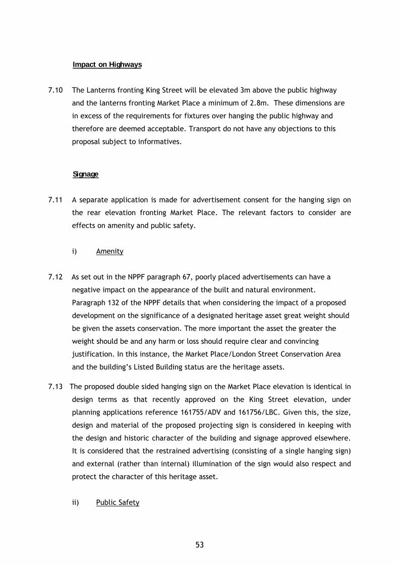
Impact on Highways
7.10 The Lanterns fronting King Street will be elevated 3m above the public highway
and the lanterns fronting Market Place a minimum of 2.8m. These dimensions are
in excess of the requirements for fixtures over hanging the public highway and
therefore are deemed acceptable. Transport do not have any objections to this
proposal subject to informatives.
Signage
7.11 A separate application is made for advertisement consent for the hanging sign on
the rear elevation fronting Market Place. The relevant factors to consider are
effects on amenity and public safety.
i) Amenity
7.12 As set out in the NPPF paragraph 67, poorly placed advertisements can have a
negative impact on the appearance of the built and natural environment.
Paragraph 132 of the NPPF details that when considering the impact of a proposed
development on the significance of a designated heritage asset great weight should
be given the assets conservation. The more important the asset the greater the
weight should be and any harm or loss should require clear and convincing
justification. In this instance, the Market Place/London Street Conservation Area
and the building’s Listed Building status are the heritage assets.
7.13 The proposed double sided hanging sign on the Market Place elevation is identical in
design terms as that recently approved on the King Street elevation, under
planning applications reference 161755/ADV and 161756/LBC. Given this, the size,
design and material of the proposed projecting sign is considered in keeping with
the design and historic character of the building and signage approved elsewhere.
It is considered that the restrained advertising (consisting of a single hanging sign)
and external (rather than internal) illumination of the sign would also respect and
protect the character of this heritage asset.
ii) Public Safety
53
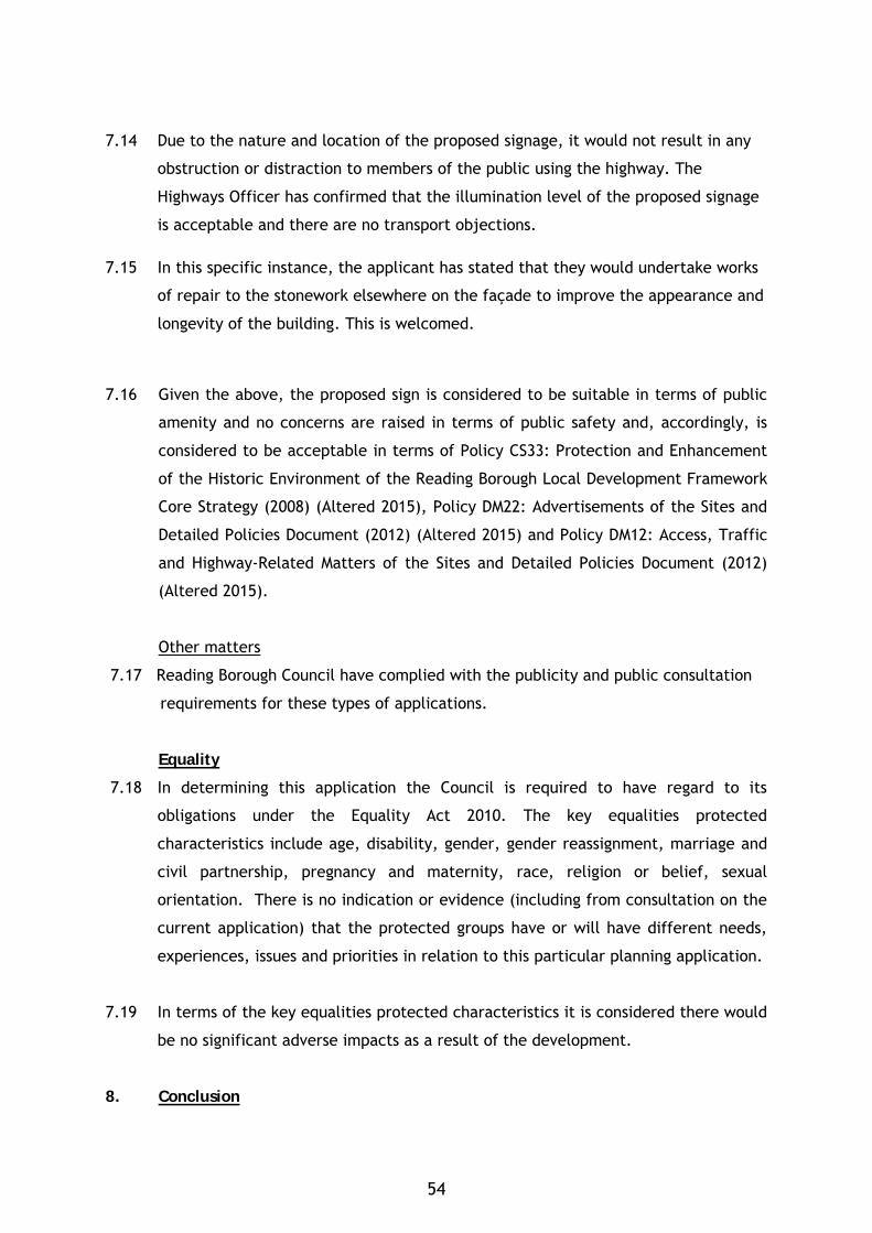
7.14 Due to the nature and location of the proposed signage, it would not result in any
obstruction or distraction to members of the public using the highway. The
Highways Officer has confirmed that the illumination level of the proposed signage
is acceptable and there are no transport objections.
7.15 In this specific instance, the applicant has stated that they would undertake works
of repair to the stonework elsewhere on the façade to improve the appearance and
longevity of the building. This is welcomed.
7.16 Given the above, the proposed sign is considered to be suitable in terms of public
amenity and no concerns are raised in terms of public safety and, accordingly, is
considered to be acceptable in terms of Policy CS33: Protection and Enhancement
of the Historic Environment of the Reading Borough Local Development Framework
Core Strategy (2008) (Altered 2015), Policy DM22: Advertisements of the Sites and
Detailed Policies Document (2012) (Altered 2015) and Policy DM12: Access, Traffic
and Highway-Related Matters of the Sites and Detailed Policies Document (2012)
(Altered 2015).
Other matters
7.17 Reading Borough Council have complied with the publicity and public consultation
requirements for these types of applications.
Equality
7.18 In determining this application the Council is required to have regard to its
obligations under the Equality Act 2010. The key equalities protected
characteristics include age, disability, gender, gender reassignment, marriage and
civil partnership, pregnancy and maternity, race, religion or belief, sexual
orientation. There is no indication or evidence (including from consultation on the
current application) that the protected groups have or will have different needs,
experiences, issues and priorities in relation to this particular planning application.
7.19 In terms of the key equalities protected characteristics it is considered there would
be no significant adverse impacts as a result of the development.
8. Conclusion
54
8.1 The recommendation is to approve the listed building and advertisement
consents as revised, subject to conditions, for the reasons given above.
Plans
• Drawing No: 1127-PDI-60a Proposed Front Lighting Application Option 2
Received 17th May 2017
• Drawing No: 1127-PDI-48 Rev F Proposed Rear Signage Application
Received 8th May 2017
55
Case Officer: Ethne Humphreys
56

KATESGROVE
57

58
COMMITTEE REPORT BY THE DIRECTOR OF ENVIRONMENT AND NEIGHBOURHOOD SERVICES READING BOROUGH COUNCIL PLANNING APPLICATIONS COMMITTEE: 31 May 2017 ITEM NO.10 Ward: Katesgrove App No.: 170019/FUL Address: Existing Car Park East Street Reading Proposal: Erection of 4 storey building to provide 103 student accommodation units (Sui Generis), landscaping, access and ancillary works, following removal of a 49 space car park. Applicant: Studious Construction (Reading) Limited Date received: 15th February 2017 Major Application 13 week target decision date: Extension agreed to 5th June 2017 RECOMMENDATION REFUSE planning permission for the following reasons:
1. The proposed building by reason of its scale, form and dominant massing, use of inappropriate materials and lack of detailing is unsympathetic and would fail to enhance or preserve the character and appearance of the Market Place/London Street Conservation Area. Furthermore, it would have a detrimental impact on the
settings of the rear of listed buildings in London Street and thus harm the significance of those buildings. It is thus contrary to Policies CS7 and CS33 of the Reading Borough LDF Core Strategy 2008 (Altered 2015), DM4 of the Sites and Detailed Policies Document 2012 (Altered 2015) and to S.66(1) and S.72(1) of the Planning (Listed Buildings and Conservation Areas) Act 1990.
2. The proposal fails to demonstrate in a sequential test that there is an alternative
location for such development, which is classified by the Environment Agency as “more vulnerable” and part within Flood Zone 2, and that the potential risks from flooding such as reduced flood water storage, impedance to flow or risks to life and property are acceptable or can be mitigated. It is thus contrary to Policy CS35 of the Reading Borough LDF Core Strategy 2008 (Altered 2015).
3. The proposed development does not comply with the Local Planning Authority’s
standards in respect of arrivals and departure procedure at the beginning and end of term and as a result constitutes a highway safety hazard in conflict with Policy CS24 of the Reading Borough LDF Core Strategy 2008 (Altered 2015) and Policy DM12 of the Reading Borough LDF Sites and Detailed Policies Document 2012 (Altered 2015).
4. The proposed development does not comply with the Local Planning Authority’s standards in respect of secure cycle storage provision. In particular, insufficient information has been provided on access to the cycle storage location on Level 0 to ensure that this alternative mode of travel is encouraged. It thus conflicts with the aims of Policies CS23 and CS24 of the Reading Borough LDF Core Strategy 2008 (Altered 2015) in this regard.
5. In the absence of a completed legal agreement to secure an Employment and Skills Plan and use of the living accommodation to be occupied as student accommodation (Sui Generis) only, the proposal will not mitigate its impact on the social and economic infrastructure of the borough, contrary to Policies CS3
59
and CS9 of the Reading Borough LDF Core Strategy 2008 (Altered 2015), Policy DM3 of the Reading Borough LDF Sites and Detailed Policies Document 2012 (Altered 2015) and the Council’s Adopted Supplementary Planning Documents on Employment, Skills & Training (2013) and Planning Obligations under Section (2015). 6. The loss of trees on site with insufficient opportunity for replacement planting
and landscaping visible from the public realm would be unacceptable in this urban setting and detrimental to the long term character of the Market Place/London Street Conservation Area. It is thus contrary to Policy CS7 of the Reading Borough LDF Core Strategy 2008 (Altered 2015) and Policy DM18 of the Sites and Detailed Policies Document 2012 (Altered 2015).
Informatives: 1. Plan numbers & documents (as detailed below the conclusion section of this
report).
2. The local planning authority has worked with the applicant in a positive and proactive way by clearly setting out concerns relating to the proposal.
3. Without prejudice to any future application or appeal, the applicant is advised that reason for refusal 5 could be overcome by entering into a Section 106 legal agreement or unilateral undertaking for a scheme that was in all other respects acceptable.
4. The applicant is advised that the refused scheme, had it been able to be approved, would have been a CIL (Community Infrastructure Levy) liable development.
1. INTRODUCTION
1.1 The application site comprises a landscaped private car park used by nearby office buildings (including New Century Place) at the north end of East Street, sloping gradually down towards Queens Road and entered opposite Bourne-Stevens Close. There are various retaining walls, raised planters, hedges and trees and an electricity sub-station on the site.
60
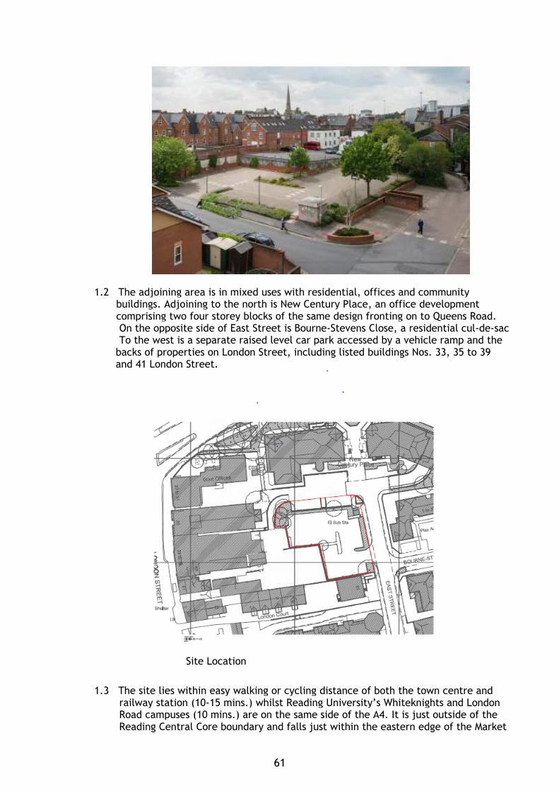
1.2 The adjoining area is in mixed uses with residential, offices and community buildings. Adjoining to the north is New Century Place, an office development comprising two four storey blocks of the same design fronting on to Queens Road. On the opposite side of East Street is Bourne-Stevens Close, a residential cul-de-sac To the west is a separate raised level car park accessed by a vehicle ramp and the
backs of properties on London Street, including listed buildings Nos. 33, 35 to 39 and 41 London Street.
Site Location
1.3 The site lies within easy walking or cycling distance of both the town centre and railway station (10-15 mins.) whilst Reading University’s Whiteknights and London Road campuses (10 mins.) are on the same side of the A4. It is just outside of the Reading Central Core boundary and falls just within the eastern edge of the Market
61
Place/London Street Conservation Area, the boundary of which runs along the centre of East Street. Approximately one fifth of the site, which slopes down by one metre towards the north east corner falls within Flood Zone 2 of the River Kennet
2. PROPOSAL
2.1 Permission is sought for the erection of a four storey (plus part basement) privately managed student accommodation building with an L-shaped footprint in two wings (north/south) to provide 103 studio rooms following removal of a redundant 49 space car park and existing trees/planting.
2.2 The main entrance would be on the north side opposite New Century Place and there would be a small garden at the rear towards the south-west boundary of the site alongside the separate raised car park. The south wing in East Street would be set back from the road and landscaped with low level planting and new trees. 2.3 The ground floor (Level 0) of the building would include the reception office and a residents lounge. There is no vehicle parking whilst an indoor refuse bin area would be located within the north wing and a secure covered cycle store for up to 40 bicycles is to be provided at the southern end of the south wing.
2.4 As a result of discussions with officers principally relating to the scale and impact on the surrounding area, the applicant has amended the scheme as follows:
- increased set back by 3m with planting on East Street frontage; - reduction of overall height (by one storey with part of south wing in East Street
stepped down further), bulk and massing; - break up of East Street elevation with stepped facades and glass Juliet
balconies; - introduction of vertical column elements within façade to add texture, interest
and verticality; - precast buff concrete cornice detail to brickwork head and band (Level 1); - windows grouped to increase verticality - increased roof overhang; - rearranged internal layout to incorporate step and relocation of staircase; - reduction in overall bed numbers to 103;
2.5 The applicant has a proven track record of student accommodation throughout the UK and in support has stated that amongst the benefits are that the proposal would contribute to the Borough’s housing requirement and thus relieve pressure for such accommodation on the private rented sector; bring additional expenditure into the town; and by using a vacant office car park for a car-free development thereby reduce traffic movements with positive implications for the environment.
2.6 Externally the building would be finished in facing brick with precast concrete cornices; aluminium powder coated windows and doors (double glazed, clear or infill), glass balustrades with opaque panels (coloured inner layer); opaque (double glazed) and translucent glass spandrel panels (laminated) and aluminium powder coated louvres.
2.7 The application is being reported to your meeting as a Major Application and Members have undertaken a recommended unaccompanied site visit.
62
3. PLANNING HISTORY
3.1 162137 Pre-application advice for proposed new OBSERVATIONS purpose built student accommodation (PBSA) SENT 6.1.2017 (Use Class Sui Generis) comprising up to 139 units across a mix of studios / twodios/ 1 bed apartments and shared communal recreational living facilities, all associated car parking, landscaping, access and ancillary works.
4. CONSULTATIONS
4.1 Statutory:
Environment Agency:
Have commented that the application is covered by EA Flood Risk Standing Advice and therefore they should not be consulted and will not provide a response.
For information have advised that their maps indicate a very small area of Flood Zone 2 affects the site and the applicant should provide a Flood Risk Assessment in order for (RBC) to consider the development. As part of the FRA the applicant should include all relevant flood levels and extents. Also recommend review of RBC Strategic Flood Risk Assessment for any further detail in relation to this area.
4.2 Non-statutory:
RBC Historic Buildings Consultant: Objection - the proposed development would not enhance or preserve the
character and appearance of the Conservation Area and is considered to harm the significance of Listed Buildings along London Street contrary to considerations as set out in sections 72(1) and section 66(1) of the Planning (Listed Buildings and Conservation Areas) Act 1990 and would fail to meet the requirements of the NPPF and RBC Policy CS33.
Additionally, has made the following comments which are summarised here.
The proposed site is located within the Market Place and London Street Conservation Area. The Market Place/London Street Conservation Area was designated in 1972 and extended in 1982 and the Market Place/London Street Conservation Area Appraisal document was adopted by Reading Borough Council in 2007.
The proposed site is located within Area 1: London Street. London Street has medieval origins and though many of its buildings have a distinctively Georgian, and later, appearance, parts of older structures can be found. There are a few remaining 16th/17th century buildings including Nos. 49-53 London Street (Grade II Listed) which has an 18th century front on an earlier, timber- framed building; and No. 88 London Street which has a jettied first floor to Church Street whilst Nos. 49/51 London Street contains 17th century panelling. Many of the elegant houses which lined either side of the road still survive though altered and no longer in residential use and devoid of their spacious rear gardens
63
and these are the properties which today add grandeur to the street scene. The settings of the main Grade II Listed Buildings potentially affected are: No. 33 (Former Everyman Theatre and former Formerly Primitive Methodist Chapel) now the Great Expectations Hotel; Nos. 35, 37 and 39, 41 and 49-53 London Street; and Queen’s Crescent. The character of the Conservation Area is not entirely embodied in the architectural quality of London Street. There are important historic associations and locally characterful historic buildings and spaces which are not picked up in the applicant’s Heritage Assessment. The RISC shop (35-39 London Street), has associations with William Penn, who founded Pennsylvania in the USA and as a member of the Friends Society of Reading attended a meeting place at that site. To the rear of 35-39 London Street is a narrow passageway with an outbuilding and former workshops which contribute to the Conservation Area including a three storey 19th century warehouse and includes an adjacent roof top garden used by members of RISC which directly overlooks the proposed development site. The area is also historically associated with Charles Dickens, in the name of the Great Expectations hotel, where he performed a solo reading of “A Christmas Carol” in 1860. The rear of the Great Expectations faces out towards the proposed site. The proposed site is located on land which is lower than the rear of the main Listed Buildings and the land generally slopes away from the south to Queens Road to the north. The proposed site is currently a car park which is considered a neutral space with a large area of hard-standing within the Conservation Area, but provides views and legibility towards the rear elevations of the Listed Buildings along London Street.
Around the site are a number of modern buildings including the two New Century Place developments along which front Queen’s Road and are 4 storeys high with pitched roofs built of red brick with a concrete blockwork plinth. The Central Point on corner of Queen’s Road and London Street a 5 storey high building is also of red brick. Around the site are further developments which are generally 2 to 3 storeys and built of red brick with pitched roofs and bands of buff brickwork.
The height of the proposed front elevation onto East Street has the most potential to affect the rear settings of Nos. 33 and 35 to 39 London Street. The latter listed building in particular includes a group of characterful non-designated heritage assets to the rear including a former 19th century warehouse/workshop with adjacent roof terrace overlooking the proposed development.
The front elevations of the London Street Listed Buildings are directly connected to the rear of the buildings by historic alley ways which means that this space is linked and has an effect on their appreciation and significance as heritage assets. As stated in Planning Note 2: Managing Significance in Decision-Taking (Historic England, 2016) back elevations can be important, as can side views from alleys and yards.
In relation to the Conservation Area, the addition of a building of such large scale and mass on this site would reduce the appreciation of the rear elevations of the Listed Buildings and unlisted buildings of historic interest and would not meet the
64
requirement to preserve or enhance the character and appearance of the Conservation Area in replacing the neutral presence of the existing car park.
The local authority has a statutory duty to have special regard to the desirability of preserving the building or its setting or any features of special architectural or historic interest which it possesses under Section 66(1) and ‘with respect of any building or other land in a conservation area......special attention shall be paid to the desirability of preserving or enhancing the character or appearance of that area under Section 72(1) of the Planning (Listed Building and Conservation Area Act) 1990. In addition there is an overriding statutory requirement specified in the Act under Section 66(1) which states that ‘in considering whether to grant planning permission for development which affects a listed building or its setting, the local planning authority…..shall have special regard to the desirability of preserving the building or its setting…...’.
The proposed architectural form of the proposed design consisting of a 5 storey building with a flat roof is considered to be too large in terms of its mass and scale in relation to surrounding historic buildings and spaces in order to achieve the statutory requirement to preserve or enhance the character and appearance of the Conservation Area. The height of the proposed when taken in conjunction with the mass of the proposed building its flat roofed form and its aluminium cladding, would harm the Conservation Area and visually impact the settings of the Listed Buildings to the rear. The proposed building’s location directly abutting East Street without any surrounding neutral public space would represent a dominant and oppressive presence in the street scene of the Conservation Area. No design concessions have therefore been made to the address the character of the Conservation Area or the settings of the Listed Buildings.
Whilst some of the context for the proposed site is represented by modern four storey offices buildings of indifferent quality, these buildings are confined to ring to the east of East Street (outside the Conservation Area) or along the busy Queens Street main road.
AMENDED PLANS – further comments as follows:
Despite the reduction in height of the proposed building, the perceived ‘bulkiness’ of the building persists and it is considered that it would dominate the street scene particularly along East Street. This bulkiness is partly due to the ‘box-like’ appearance of the building, which has not been suitably broken-up, and the combination of a flat-roofed form with the scale and mass of the building.
In addition the unsympathetic appearance of the proposed building is exacerbated by the use of inappropriate materials such spandrel panels, for which no details are given, and use of basic ‘stock’ bricks as the dominant materials. These standard, mass-produced materials are not considered appropriate to the special character of the conservation area where high quality, bespoke materials which would enhance its character and appearance are generally to be expected in order to mitigate any potential harm to the area.
Whilst the increase in setting-back the front elevation of the proposed building, away from East Street, from c.0.5m to c.3m, is welcomed, this has resulted in the encroachment of the building further towards the rear elevations of the Listed Buildings on London Street. The importance of the rear settings of the Listed Buildings along London Street, and the spaces between them, has been highlighted in previous consultation letters.
65
The amendments to the design have not adequately addressed concerns with the proposed development which is considered to be too bulky, dominant and unsympathetic to settings of the surrounding historic buildings and character and appearance of the conservation area. The bulk of the proposed building when taken in conjunction with the flat roofed form and the proposed external materials would harm the conservation area and the significance of the Listed Buildings and would not preserve their settings.
RBC Natural Environment (Trees/Landscape): Objection for the following reasons: The survey has identified 5 trees and one group of trees on or adjacent to the development site. The trees are highly visible from East Street and selective individuals are visible in wider views from Queens Road. All trees have been identified as category ‘C’ trees. Having viewed the trees on site I agree that most are category C although trees T1 & T4 would possibly be a B/C as they are reasonable specimens though small and are of moderate quality with an estimated life expectancy of at least 20 years.
Although category ‘C’ trees should be a material consideration on the design process, individually they would not usually be a constraint on the reasonable development of a site and there is the possibility that the Council would agree to the removal of trees within the site provided substantial new, high amenity planting can be achieved to mitigate their loss. The critical matter for this site is the proposed removal of all visibly prominent trees with no opportunity for new or enhanced landscape planting visible from the public realm. Allowing a new multi-storey building which abuts the adopted highway (apart from a narrow landscape strip) following the removal of the few trees on site and with no opportunity for replacement planting would be unacceptable in this urban setting and detrimental to the long term character of the Conservation Area.
I understand that private amenity space is proposed to the rear of the property however this will be small and well shaded. Any trees and landscaping in this space would be obscured and do very little to enhance the amenity of the wider area. Trees planted in the private garden space will create excessive shade and would soon be heavily pruned or removed in order to increase light levels and reduce the nuisance of leaf drop and other small scale debris for residents. As I advised in my pre application consultation response, although in principle there are no objections to the redevelopment of the site, an appropriate scheme would look to retain sustainable landscaped beds adjacent to East Street and include quality new tree planting in a prominent location at the front of the site in order to enhance the amenity of East Street and the Conservation Area.
AMENDED PLANS – further comments requested to be reported in an update at the meeting.
RBC Natural Environment (Ecology): No comments received.
RBC Transport Strategy: Objection - The proposed development does not comply with the Local Planning Authority’s standards in respect of arrivals and departure procedure at the
66
beginning and end of term and, as a result, is in conflict with Core Strategy Policy CS24 and Sites and Detailed Polices document Policy DM12.
The proposed development does not comply with the Local Planning Authority's standards in respect of secure cycle storage provision. This is in direct conflict with Core Strategy Policies CS23 and CS24.
In addition makes the following comments:
The site is located on the periphery of the central core area which lies at the heart of Reading Borough, consisting primarily of retail and commercial office developments with good transport hubs. This area is well served by rail and bus links and also contains the largest proportion of public car parking spaces. The site is within 250m of the Oracle shopping centre and multi-storey car park and within 500m of Broad Street with a range of shops and services. East Street and the surrounding classified road network all have parking restrictions preventing on-street parking.
The site is currently in use as a private car park with a total of 49 spaces. These spaces form part of the parking provision associated with the adjacent office buildings at 1 New Century Place. The Councils Parking standards would require a maximum provision of 1 space per 250m² for Zone 1 and 1 space per 100m² for Zone 2, the site is located on the boundary between the two, this would require a maximum provision of 25 spaces. The retained office building is to be provided with a provision of 6 spaces, however given the sustainable location of the site and the parking constraints surrounding the site I am happy that the loss of parking is deemed acceptable.
A Transport Statement has been submitted to accompany the application and I comment on this below:
Parking Provision - The site is located in Zone 2, Primary Core Area, of the Revised Parking Standards and Design SPD. This zone directly surrounds the Central Core Area and extends to walking distances of 2 kilometres from the centre of Reading. The parking standards set for Halls of Residence located in this zone are 1 space per FTE member of staff and no requirements for students, however, there are no adopted parking standards for student accommodation which are provided “off campus” and operate as independent providers of higher education accommodation. Therefore, an application of this type is likely to be considered on its own merits considering local circumstances including access to public transport provisions and the availability of parking and on-street regulations.
The redevelopment proposals will not provide any car parking spaces, for staff or students, reflecting the sustainable location of the site. It is also proposed that students and staff would not be permitted to apply for a parking permit to ensure that there is no detrimental impact on the local on-street parking. This approach complies with policy.
In addition, a Management Plan will be put in place with the aim to minimise disruptions to the local area and to avoid unnecessary queues and delays at the Site at the start and end of the academic year. However there appears to be very limited management of the moving in procedure other than providing information regarding restrictions around the development site, the management plan refers to the following:
67
• The arrival date is generally at the individual student’s choice, however, the Accommodation Management (as a section of the Application Form) must be notified in advance to ensure that if there are any instances of numerous coincident arrivals or arrivals at inappropriate times, this can be addressed through rearrangement with the students involved well in advance of their arrival.
• Details of parking and loading provision in the immediate locality will be provided with comprehensive information on restrictions, length of stay and penalties.
• Parking bays localised to the scheme will be suspended for use only for new arrivals to move in on the assigned move in weekend only. Tenants will be told these bays are for unloading only and will be directed to other parking areas.
The moving in procedure must be suitably managed to ensure that an excessive number of vehicles does not try to gain access to the site at anyone time. No on site facilities for this operation have been provided and it is solely reliant on the Public Highway. However there are no guarantees that existing restrictions will remain and what take up would be of the pay and display bays in the area. Any proposal should therefore be able to accommodate its own demand on site. It should also be stated that the Highway will not permit the suspension of parking bays for the arrivals and collections of students. An updated Management Plan is therefore required to tighten up the arrivals and collection procedure and ensure that it is contained on the application site.
In accordance with the Councils Parking Standards and Design SPD, students should be prohibited from bringing vehicles to the site through a tenancy agreement stating that residents will not be permitted to keep a car in Reading. This must form part of the signed Tenancy Agreements which will run for the entire period of their tenancy. This requirement will need to be part of a Travel Plan.
Trip Generation - The proposed development will result in the loss of car parking for the adjacent office and as a result will lead to a reduction in vehicle trips on the network. The principle of the development is therefore acceptable.
Given that the principle is accepted that the trips will reduce the trip rate information that has been supplied within the TS has not been reviewed and confirmed as acceptable.
Sustainable Travel - A framework Travel Plan has been submitted to encourage safe, healthy and sustainable travel options and this is deemed acceptable. The full travel plan should be submitted 3 months after occupation so that full survey data can be provided of residents.
Cycle Parking - In accordance with the Council’s Revised Parking Standards and Design SPD, the development would be required to provide 1 cycle parking space per 3 staff and 1 space per 5 students. It is indicated that there will be up to 30 cycle stands provided within the building, which will be double stacked. This has been deemed acceptable in principle.
However, the cycle store is not sufficient in depth to accommodate the proposed type of cycle parking. The installation guide for this type of cycle store is that a depth of 4m would be required. In addition the access to the store is in adequate and therefore will not help encourage cycling as an alternative mode.
Revised drawings are therefore required to improve the cycle parking infrastructure. This could usually be dealt with by way of a condition but given that this involves the internal layout of the building and access arrangements this
68
must be undertaken as the application stage given the knock on impacts this would have for the building.
Access & Servicing - Current service and delivery arrangements will not be affected by the proposed change of land use and will therefore remain unchanged. Drawing 1607-73 SP03 shows the swept path analysis of a large refuse vehicle accessing the Site`s curtilage in forward gear from East Street and then reversing into the collection point and driving out in forward gear. The drawing does result in the refuse vehicle having to travel through the pay and display parking bays on the east side of East Street which would not be acceptable if vehicles were parked in the bays. However, servicing of the adjacent buildings would be undertaken from the same location currently and therefore vehicles are currently able to undertake the manoeuvre and there is just an error with the submitted drawing. Given there are no changes to the current restrictions I am happy that this can continue.
The existing access into the site will no longer be required for vehicular access, therefore, this should therefore be abandoned and with the footway reinstated to line and level.
Please ask the applicants agent to submit suitably amended plans / information to address the above points prior to determining the application. AMENDED PLANS – further comments requested to be reported in an update at the
meeting.
RBC Waste Minimisation & Recycling Officer:
No comments received.
RBC Emergency Planning Officer:
No comments received.
RBC Environmental Health (Protection & Nuisance):
No objection subject to conditions requiring installation of glazing and ventilation in accordance with the submitted acoustic assessment; an assessment of the potential site contamination plus a remediation scheme and reporting of any unexpected contamination; a scheme for control of noise and dust plus hours of working and no bonfires during the construction and demolition phase with the following comments:
A noise assessment should be submitted in support of applications for new residential proposed in noisy areas. The noise assessment will be assessed against the recommendations for internal noise levels within dwellings and external noise levels within gardens / balconies in accordance with BS 8233:2014 and WHO guidelines for Community Noise. The report should identify any mitigation measures that are necessary to ensure that the recommended standard is met.
Where appropriate, the noise assessment data should also include noise events (LAMax) and the design should aim to prevent noise levels from noise events exceeding 45dB within bedrooms at night. Noise levels above 45dB are linked with sleep disturbance. The noise assessment submitted shows that the recommended standard for internal noise can be met, if the recommendations from the assessment are incorporated into the design. It is recommended that a condition be attached to consent to ensure that the glazing and ventilation recommendations of
69
the noise assessment will be followed, or that alternative but equally or more effective glazing and ventilation will be used.
The site is adjacent to a former works and a brewery that have the potential to have caused contaminated land. The developer is responsible for ensuring that development is safe and suitable for use for the intended purpose or can be made so by remedial action.
Ideally a ‘phase 1’ desk study should be submitted with applications for developments on sites with potentially contamination to give an indication as to the likely risks and to determine whether further investigation is necessary. Investigation must be carried out by a suitably qualified person to ensure that the site is suitable for the proposed use or can be made so by remedial action. Recommend conditions are required to ensure that future occupants are not put at undue risk from contamination.
Concerns about potential noise, dust and bonfires associated with the construction (and demolition) of the proposed development and possible adverse impact on nearby residents (and businesses). Fires during construction and demolition can impact on air quality and cause harm to residential amenity. Burning of waste on site could be considered to be harmful to the aims of environmental sustainability. RBC Sustainability: No comments received. Historic England: Do not wish to offer any comments. Not necessary to be consulted again unless there are material changes to the proposals. AMENDED PLANS - further comments requested to be reported in an update at the meeting.
Reading Conservation Area Advisory Committee:
No representations received. AMENDED PLANS - comments requested to be reported in an update at the meeting.
Berkshire Archaeology: The Archaeological Desk-Based Assessment submitted with the application provides detailed information regarding the known archaeological potential of the area and the previous uses of the proposal site through historic mapping. In summary the report finds that the proposal site, situated off London Street which is medieval in origin, is located within an area of potential for medieval back plot activity such as ditches and pits and post-medieval activity, including the potential for remains related to the Civil War defences. The report also concludes that medieval remains are likely to have been truncated by later developments and are likely to be fragmentary, therefore any archaeological issues can be mitigated via a planning condition.
The desk-based assessment provides a good assessment of the archaeological
70
potential. Previous archaeological investigations in the area have shown that there is a good potential for medieval and post-medieval finds and features to survive however the closest archaeological work at East View Place, to the south, did find the archaeological features to be have been truncated. However some of the ditches revealed during these archaeological investigations were recorded as continuing beyond the northern limit of the site and therefore there is the potential that these features may extend into the proposal site.
Due to the potential for archaeological remains to be impacted by the proposed development further information from field investigation is required. We would recommend an initial phase of trial trenching prior to development to evaluate the archaeological potential within the site. Depending on the results of the trial trenching further phases of investigation prior to development may be required and adequate time should be allowed for this within the development programme.
Recommend that a condition requiring approval of a written scheme of archaeological investigation is attached to any planning permission granted, to mitigate the impact of the development.
Crime Prevention Design Officer: No comments received.
Thames Water:
Sewer records don’t indicate any shared drainage within the site, but there may be newly transferred sewers that we haven’t yet mapped and aren’t aware of. If the site owner finds shared drainage, the sewers may need to be diverted, as we don’t allow new builds over public sewers. They will need to submit their pre-development application to us and then discuss any potential diversions with the engineer dealing with their application.
Reading UK Chamber of Industry & Commerce: No comments received.
Neighbour Notification: Properties in London Street, East Street (incl. London Court, East View Place), Bourne-Stevens Close and New Century Place were consulted on 21st February 2017. In addition, conservation area site notice(s) were displayed.
AMENDED PLANS - re-consultations were undertaken with all previous respondents on 15th May 2017 and any additional comments received in further responses will be reported in an update at the meeting. Site notices describing the amended proposals were displayed on 16th May 2017.
In total there have been 5 objections received to the original plans with the following comments and issues raised: Scale, design & layout:
- height not in keeping (eg. New Century Place is 4 storeys) - out of scale (5 storeys), proportion, context and character with pattern in East
Street - pedestrian route to Queens Road between 1 & 2 New Century Place would be an oppressive corridor
71
- overdevelopment (cramming) – loss of trees/vegetation would not benefit landscape or environment
Impacts on conservation area/settings of listed buildings::
- detrimental to character of Conservation Area (does not preserve or enhance) - affects rear setting of listed buildings (eg. historic alleyways/proximity to rear boundary of Nos. 35-39 London Street (RISC - including roof garden/meeting rooms) and No. 33 London Street (Great Expectations - with rear entrance to bars)
Impact on residential amenities:
- noise/access during construction - dominant – too close to residential buildings of 2-3 storeys - loss of light and views (from East View Place) - potential impact on daylight/sunlight (overshadowing) of London Street properties (mostly 3 storeys or less incl. Bourne Stevens Close, London Court) - overlooking/loss of privacy (to East View Place); loss of quiet, green open space (which includes RISC roof garden) and safe environment
Traffic, highway & car/cycle parking issues: - loss of car parking (for New Century Place)
Other issues:
- amenity area could be sited better to separate buildings
5. RELEVANT POLICY AND GUIDANCE
5.1 Section 38(6) of the Planning and Compulsory Purchase Act 2004 requires that proposals be determined in accordance with the development plan unless material considerations indicate otherwise. Material considerations include relevant policies in the National Planning Policy Framework (NPPF) published in March 2012 - among them the 'presumption in favour of sustainable development'. However the NPPF does not change the statutory status of the development plan as the starting point for decision making (NPPF paragraph 12).
5.2 In this regard, the NPPF states that due weight should be given to the adopted
policies of the Local Development Framework (LDF) (Core Strategy and Sites and Detailed Policies Document) according to their degree of consistency with the NPPF. The closer the policies in the plan are to the policies in the NPPF, the greater the weight that may be given.
5.3 In Paragraph 7, the NPPF defines sustainable development and the social role of
the planning system in supporting strong, vibrant and healthy communities by providing the supply of housing required to meet the needs of present and future generations. In Section 6: Delivering a Wide Choice of High Quality Homes local planning authorities are advised to boost significantly the supply of housing and that applications for such should be considered in the context of the presumption in favour of sustainable development.
5.4 Accordingly, the National Planning Policy Framework and the following
development plan policies and supplementary planning guidance are relevant:
Reading Borough LDF Core Strategy 2008 (Altered 2015) CS1 Sustainable Construction and Design CS2 Waste Minimisation CS4 Accessibility and the intensity of development
72
CS5 Inclusive Access CS7 Design and the Public Realm CS9 Infrastructure, Services, Resources and Amenities CS20 Implementation of the Reading Transport Strategy CS23 Sustainable Travel and Travel Plans CS24 Car/Cycle Parking CS33 Protection and Enhancement of the Historic Environment CS34 Pollution and Water Resources CS35 Flooding CS36 Biodiversity and Geology CS38 Trees, Hedges and Woodland
Sites and Detailed Policies Document 2012 (Altered 2015) SD1 Presumption In Favour Of Sustainable Development DM1 Adaptation to Climate Change DM3 Infrastructure Planning DM4 Safeguarding Amenity DM10 Private and Communal Outdoor Space DM12 Access, Traffic and Highway-Related Matters DM18 Tree Planting DM19 Air Quality SA14 Cycle Routes
Supplementary Planning Guidance Revised Parking Standards and Design SPD (2011) Revised SPD Planning Obligations under Section 106 (2015) Sustainable Design and Construction SPD (2011) Employment, Skills and Training SPD (2013)
6. APPRAISAL 6.1 The main issues to be considered are:
a) Principle of use/location b) Design, massing, scale & effect on character of the Conservation Area/settings of listed buildings c) Impact on amenities of surrounding residential properties d) Transport issues (parking, traffic & access) e) Infrastructure (S106, CIL) f) Other (landscaping, drainage & flooding)
Principle of use/location
6.2 The site is located within a mixed use area with business and community uses adjoining residential development. It is an accessible location on the edge of the town centre with its many facilities, shops and public transport options. Whilst the Council has no current adopted policy relating to the location of student accommodation, the proximity to the main Reading University campuses to the east, whether reached on foot, by bus or bicycle is an advantage.
6.3 As has been done with other recent student accommodation schemes in the
Borough, the standard approach is to restrict the use of the living accommodation to be occupied as student accommodation (Sui Generis) only, to be secured via a legal agreement rather than a condition. With the reasons for
73
refusal given elsewhere in this report, this therefore forms an additional reason for refusal.
Design, massing, scale & effect on character of the Conservation Area/impact on settings of listed buildings
6.4 Policy CS1 (Sustainable Construction and Design) of the Reading LDF Core Strategy 2008 (Altered 2015) relates to both new buildings and the refurbishment of existing buildings. Proposals are acceptable where the design of buildings and site layouts use energy, water, minerals, materials and other natural resources appropriately, efficiently and with care.
6.5 Policy CS7 of the Core Strategy seeks to ensure that development is of a high design quality that maintains and enhances the character and appearance of the area in which it is located. Among the urban design objectives of the policy are that this should make a positive contribution to the character, continuity and quality of the public realm.
6.6 Policy CS33 confirms that historic features and areas of historic importance and other elements of the historic environment, including Conservation Areas and their settings, will be protected and where appropriate enhanced. All proposals will be expected to protect and enhance the character and appearance of the area in which they are located.
6.7 The proposed student accommodation building would provide a good standard of living accommodation with facilities including the necessary secure entrance from the street in a managed and landscaped setting. An analysis of the visual impact of the new building in the street, its scale, massing, form and detailed appearance is made here. 6.8 The proposals have been amended to improve the relationship with the public realm in East Street by setting back the west elevation of the south wing as far as possible with this layout and given the depth and shape of the site. This provides an opportunity for softening the forward bulk of the building when viewed from East Street. However, in appearance and scale the length of the continuous façade presented at street level would appear as a dominant and visually intrusive feature and would create corridor-like views. 6.9 In terms of the scale and massing, the scheme constitutes two component wings (north and south) linked in one block. As a result of discussions with officers, the applicant has amended the proposals by deleting one storey to fours storeys in height (excl. basement level) with a further step down at its southern end. 6.10 The revised maximum height would thus be kept below the eaves level of the New Century Place offices and pays some regard to the generally lower building storey heights of residential development in East Street (which are on slightly higher ground) and Bourne-Stevens Close. There is a notable variety of building types and a wide area of view in the open “square” at the north end of East Street into which the proposed building would thus appear to have
been placed regardless of its context. Its flat roof block form occupying an irregular L-shaped site would appear incongruous and whilst in all other design terms may be appropriate for the proposed use, it would thus be unsympathetic to the surroundings.
6.11 In particular, the Council’s Historic Buildings Consultant has objected to the
74
potential impacts of the proposals on the Conservation Area and settings of nearby listed buildings. The form and scale of the proposal, its massing and use of inappropriate modern materials makes little attempt to preserve or enhance
these heritage assets or the character of the Conservation Area. As such, the proposals are contrary to the Council’s adopted policies in these regards and to national planning guidance.
Impact on amenities of surrounding residential properties
6.12 Policy DM4 (Safeguarding Amenity) states that development will not cause a
significant detrimental impact to the living environment of existing or new residential properties in terms of privacy and overlooking, access to sunlight and daylight, visual dominance and overbearing, noise and disturbance, artificial lighting, crime and safety etc.
6.13 A number of concerns have been raised by local residents and occupiers about the potential impacts on daylight and privacy that are not wholly substantiated on site due to the separation distances involved and/or the orientation of any habitable room windows towards the site from East View Place situated to the south or across East Street from Bourne-Stevens Close which faces the site with one blank wall (at 15m) and a set-back return with window (20m). The applicant has provided a daylight assessment which demonstrates that shadow from the building would reach some adjacent buildings but not block any natural daylight.
6.14 The loss of any views beyond the application site, other than in terms of the
impacts on heritage significance described elsewhere in this report, is not a reason that can be given for refusal when considering residential amenities. The dominant nature of the proposed building, which would effectively fill in the existing street scape on that side of East Street is of concern however. It would undoubtedly result in a detrimental change in how this location and the surrounding environment is perceived and add a greater sense of enclosure by large buildings with insufficient public interface for the majority of residents and as such is contrary to Policy DM4.
Transport Issues (Parking, traffic & access)
6.15 Policy CS4 (Accessibility and the Intensity of Development) of the Core Strategy relates the scale and density of development to its level of accessibility by walking, cycling and public transport to a range of services and facilities with sites assessed in terms of their accessibility to a defined district or local centre. A good level of accessibility is considered to be that within 400m of a defined centre with a good range of facilities and within 400m by pedestrian routes of a bus stop served frequently.
6.16 Policy CS20 (Implementation of the Reading Transport Strategy) of the Core Strategy considers the contribution that proposals make to a balanced Transport network whilst Policy CS24 (Car/Cycle Parking) applies the maximum car/cycle parking standards applicable in relation to the accessibility of locations within the Borough to sustainable transport facilities in particular public transport.
6.17 Policy DM12 (Access, Traffic and Highway-Related Matters) considers various implications including the additional trip generation of proposals,
which are permitted where there is no detrimental impact on the
75
functioning of the transport network or to the safety of users including pedestrians and cyclists.
6.18 The site in East Street is within walking distance of Reading Central Area and its
full range of shops and other facilities served by regular public transport and thus considered accessible. This would suit the nature of the proposed use for students who would generally arrive by car on average once at the beginning of each term.
6.19 Since this is a car-free development it is acceptable in this location to have no
on-site parking for staff or students but there are other traffic considerations relating to the moving in procedure and potential for disruption to local roads if an excessive number of vehicles arrive at the same time. This is ultimately a management issue and the Council’s Transport Strategy Development Control Officer has objected to the insufficient arrangements that have been put forward by the applicant which would not guarantee that the highway was kept available at all times for local residents and businesses.
6.20 Similarly, the on-site provision for cycling as an alternative mode of transport is in accordance with the Council’s parking standards but there has been no information provided by the applicant as to how the storage location on Level 0 (Ground Floor) would be made accessible and thus encourage its proper use. As neither of these concerns have been satisfactorily resolved at the time of
writing this report the proposals are therefore contrary to Policies CS23, CS24 and DM12.
Infrastructure 6.21 Policy CS9 (Infrastructure, Services, Resources and Amenities) of the Reading
Borough Council LDF Core Strategy 2008 (Altered 2015) states that proposals will not be permitted unless the Council is satisfied that infrastructure, services, resources, amenities or other assets lost or impacted upon as a result of the development will be re-provided. This will require planning obligations entered into by agreement to secure the replacement of social infrastructure, services, resources, amenities or other assets.
6.22 An employment, skills and training plan (construction phase) would be required to be secured via a S106 legal agreement had planning permission been recommended. In the absence of an acceptable scheme, this forms an additional reason for refusal of the application (as with securing the student use as detailed earlier in the appraisal) and this issue can be clarified by an informative.
6.23 Policy DM3 (Infrastructure Planning) of the Reading Borough LDF Sites and Detailed Policies Document 2012 (Altered 2015) confirms that appropriate provision for infrastructure, services, resources and amenities will be made through planning obligations and/or the Community Infrastructure Levy as relevant. A high priority will be given to health provision and where a specific need is identified and justified, to community facilities.
6.24 It is considered that the obligations referred to above would comply with
the National Planning Policy Framework and Community Infrastructure Levy (CIL) in that they would be necessary, reasonable and related to the development in planning terms. Had the application been supported the scheme would have been liable for CIL payments. An informative to this
76
effect can be added to the decision and under the CIL regulations such payments would be due on commencement and occupation of the development.
Other 6.25 Policy CS38 (Trees, Hedges and Woodland) of the Core strategy seeks to
protect individual trees, groups of trees, hedges and woodland from damage or removal. Policy DM18 (Tree Planting) of the Sites and Detailed Policies Document states that provision for new tree planting shall be made within development sites to enhance the character and appearance of the area.
6.26 The Council’s Natural Environment Officer has raised concerns about the
impact of the losing the amenity value of the existing trees without the opportunity for replacement on the site in a visible location. The amended plans appear to have addressed this requirement with a row of trees indicated in a landscaped setting to the front of the west elevation in East Street. Further comments have been requested from the Natural Environment Officer but until these are received there is a conflict with the wider objectives of Policy CS7 which includes landscape as one of the components of its high quality design objectives, and Policy DM18.
6.27 Policy CS34 (Pollution and Water Resources) of the Core Strategy states that development will only be permitted where it would not be damaging to the environment through air, land, noise or light pollution whilst ground and surface water quality would be preserved and water, sewerage and waste treatment infrastructure are adequate.
6.28 The applicants’ FRA and Drainage Strategy concludes that in an urban setting
where other measures are limited the most suitable sustainable drainage solution is an underground attenuation tank together with the incorporation of landscaping around the site. This is in addition to permeable paving details which could be made subject to condition(s) on any permission granted.
6.29 Under Policy CS35 (Flooding) of the Core Strategy, development in an area
identified as being at high risk of flooding or that would reduce the storage capacity of the flood plain, impede the flow of floodwater or increase the risks to life and property will not be permitted. All proposals within zones of medium or high risk identified in the Council’s Strategic Flood Risk Assessment are considered.
6.30 The guidance issued by the Environment Agency is that any development in
Flood Zone 2 or 3 requires a sequential test that compares the site to other available sites to establish which has the lowest risk and that therefore the potential risks from flooding are acceptable or can otherwise be mitigated. As such, the proposal fails to demonstrate that these risks including that to life and property, however infrequently they are likely to occur or peripheral to the site they may seem have been fully taken into account and is thus contrary to Policy CS35.
77
Matters Raised in Representation
6.31 All matters raised in representations have been considered elsewhere in this report under the relevant headings of the appraisal section. 7. CONCLUSION
7.1 The proposal for a student residence is considered acceptable in principle in terms of
its general location in the town with proximity to both the town centr facilities and attractions, public transport and Reading University campus buildings. Furthermore a good standard of student living accommodation would be created with all necessary on-site amenities for the future residents and staff in an accessible location by public transport that is not dependent on parking.
7.2 Nonetheless, there are significant concerns with this amended proposal in particular
the overall design, form and scale with detrimental impacts on the Conservation Area and listed buildings, whilst transport related issues have not been resolved. In addition, the flood risk implications have not been satisfactorily addressed.
7.3 In particular the scale and massing of the proposed student accommodation block
would be visually dominant and its form and detailed appearance unsympathetic to the surroundings. The impacts on heritage assets are described in detail elsewhere in this report whilst the effect on the general living environment would be similarly harmful.
7.4 The arrangements for student arrivals would have an impact on the highway traffic flows in the immediate vicinity of the site. As put forward these are inadequate to guarantee highway safety, traffic flow and parking for local residents and businesses. 7.5 Other aspects of the proposals relating to the cycle storage and in particular how this
secured location would be accessed to ensure its beneficial use, and the landscaping details shown on the amended plans may have been be resolved before the meeting, and an update will be provided on these.
7.6 These issues and concerns expressed in the above appraisal and through
consultations have been considered against all other relevant material considerations. Accordingly, for these reasons within the context of national and local planning policies, it is recommended that planning application be refused.
Plans: 3001 Rev F Location Plan 3003 Rev B Topographical Survey 3004 Rev B Existing Site Plan 3005 Existing Site Sections A, B, C & D 3007 Rev J Proposed Site Plan 3009 Rev B Proposed Building Distances 3010 Rev V Proposed Plan Level 0 3011 Rev Q Proposed Plan Level 1 3012 Rev K Proposed Plan Level 2 3013 Rev P Proposed Plan Level 3 3016 Rev B Proposed Plan Level Roof 3020 Rev N Proposed Elevations North & West 3021 Rev L Proposed Elevations South
78
3022 Rev B Proposed Elevations North & West COLOURED 3023 Rev B Proposed Elevations South & East COLOURED 3024 Rev B Proposed Elevations East & West Hidden Elevations 3025 Rev C Proposed Streetscape Elevations 3026 Rev E Proposed Elevations East VS052 View from NCP2 Level 3 Existing VS053 View from NCP2 Level 3 Proposed Received on 10th May 2017 002 Rev B Proposed Courtyard Landscaping Plan 3008 Rev B Proposed Block Plan 3017 Rev B Proposed Plan Basement Level 3030 Rev E Proposed Site Sections A, B, C & D 3031 Rev B Proposed Building Sections A & B 3032 Rev B Proposed Building Sections C & D VS054 View from NCP2 Level 3 Proposed VS055 View from East Street Proposed VS060C Footprint setback to East Street VS061A Landscape VS062A Scale VS063A Scale VS064C Subservience Photomontage methodology and supporting evidence (Realm, May 2017) Two Tier Rack Space Requirements Received on 11th May 2017 Supporting Documents: Planning Statement (Barton Willmore, January 2017) Design & Access Statement (Greenwell Design, January 2017) Travel Plan (Transport Planning Associates, December 2016) Phase 2 Ground Investigation (Clarkebond, December 2016) Flood Risk Assessment and Drainage Strategy (Clarkebond, September 2016) Tree Quality and Constraints Report (ADAS UK Ltd, November 2016) Archaeological Desk-Based Assessment (Orion Heritage Ltd, November 2016) Heritage Assessment (Orion Heritage Ltd, January 2017) Residences Management Plan (Collegiate AC) New Build and Refurbished Student Accommodation Services Infrastructure Report (Wilson Gray Consulting Ltd, January 2017) Daylight Assessment (Wilson Gray Consulting Ltd, December 2016) Preliminary Ecological Appraisal (ADAS UK ltd, September 2016) Noise Survey and Façade Acoustic Design Strategy (Apex Acoustics Ltd, December 2016)
External Materials Schedule Rev A (Greenwell Design, received on 10th May 2017) Landscape Proposal (Rosebank Landscaping) received on 12th May 2017
Landscape Maintenance & Management Plan (Rosebank Landscaping) received on 12th May 2017
Case Officer: Daniel Murkin
79
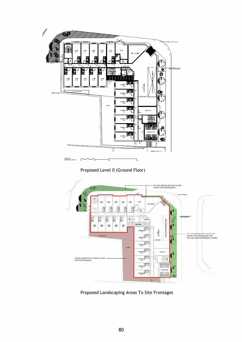
Proposed Level 0 (Ground Floor)
Proposed Landscaping Areas To Site Frontages
80
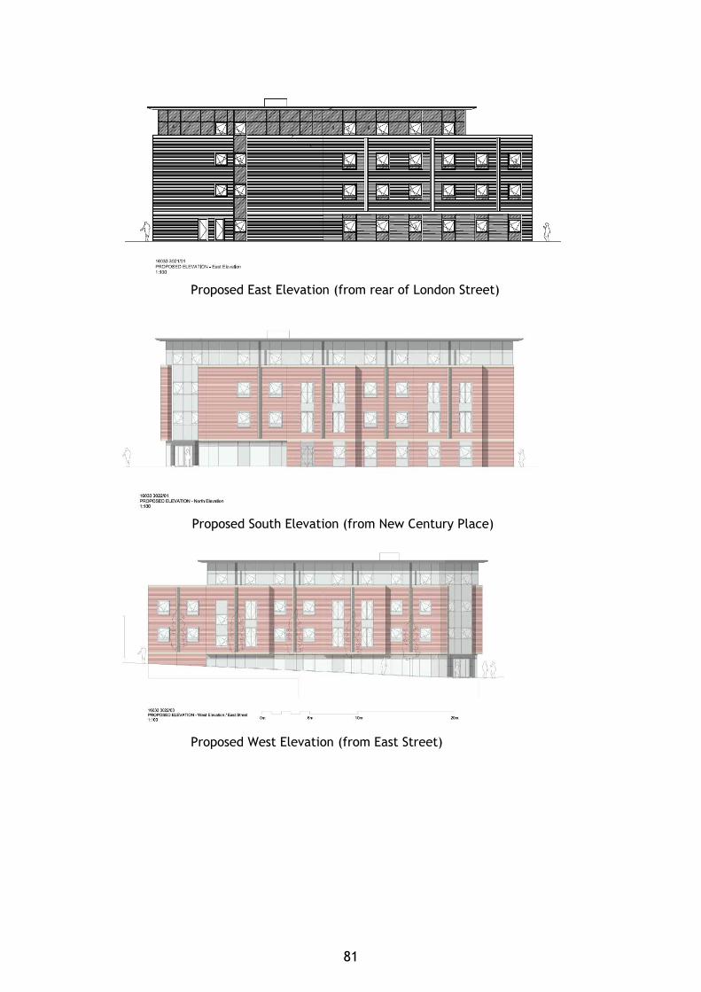
Proposed East Elevation (from rear of London Street)
Proposed South Elevation (from New Century Place)
Proposed West Elevation (from East Street)
81
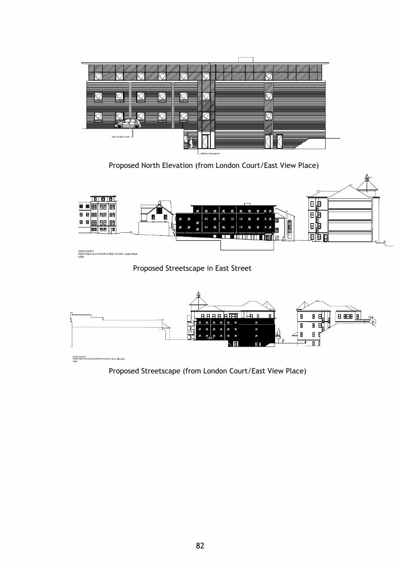
Proposed North Elevation (from London Court/East View Place)
Proposed Streetscape in East Street
Proposed Streetscape (from London Court/East View Place)
82
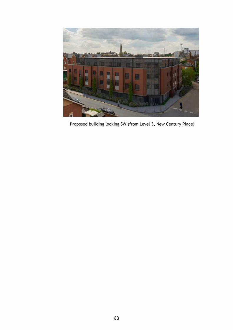
Proposed building looking SW (from Level 3, New Century Place)
83

84

WHITLEY
85

86
COMMITTEE REPORT BY THE DIRECTOR OF ENVIRONMENT AND NEIGHBOURHOOD SERVICES READING BOROUGH COUNCIL ITEM NO. 11 PLANNING APPLICATIONS COMMITTEE: 31st May 2017 Ward: Whitley App No.: 170096 App Type: Reserved Matters Address: Green Park Village, Longwater Avenue Proposal: Application for approval of reserved matters following outline approval for Phase 3B2 for 143 dwellings (10/01461/OUT) Applicant: St Edward Homes Date valid: 20th January 2017 Major Application: 13 week target decision date: 21st April 2017 Extended decision date: 9th June 2017 Planning Guarantee: 26 week date: 21st July 2017 RECOMMENDATIONS GRANT approval of Access (not approved by the original outline), Appearance, Layout, Scale and Landscape Reserved Matters
Conditions to include: 1. Approved plans. 2. Notwithstanding the provisions of the current Town and Country Planning General
Development Order, the garage accommodation on the site shall be kept available for the parking of vehicles at all times.
Informatives 1. The original planning permission 10/01461/OUT (102172) still stands and all its
conditions and informatives still apply, in particular the landscape conditions 10, 11 & 12 include ongoing requirements. This approval and that permission should be read together.
2. The applicant has informed the Council that they operate their own programme of training and apprenticeships. The Applicant is advised to liaise with Reading UK CIC with regard to developing a specific Employment Skills Plan for this scheme, in accordance with the guidelines and principles set out in the Council’s Employment, Skills and Training Supplementary Planning Document (2013) http://www.reading.gov.uk/media/1064/Employment-Skills-and-Training-Supplementary-Planning-Document-Adopted-April-2013/pdf/Employment-Skills-And-Training-Supplementary-Planning-DocumentApr13.pdf
1. INTRODUCTION 1.1 The application site is in the Green Park Village (GPV) site at the eastern side of
the overall Green Park Village development. This forms Phase 3B2 of the approved hybrid application i.e. Phase 1 in detail and the remainder in outline (under permission 10/01461/OUT (102172).
1.2 The site boundary is shown on the plan below.
87
1.3 Work has commenced on Phase 1, Phase 1c (road) and Phase 2A (Extra Care) and the enabling works for Phase 3A.
1.4 The outline approval requires details for the reserved matters to be submitted, i.e. layout, scale, appearance, accesses to and within the development (not already approved by the outline) and landscaping. The reserved matters need to be in accordance with the principles of a number of approved drawings as set out under Condition 5 of the original permission and, in particular, in accordance with the Development Guidelines in the approved Design and Access Statement, November 2010. In addition, reserved matters should also include landscaping details to meet the requirements of condition 9.
1.5 Please note that place or street names used in this report are as shown on the submitted information and are not necessarily how these street or places will formally be named.
Proposed Location Plan and Site Layout of Phase 3B2 area
Consented Outline Siting
88
2. PROPOSAL AND SUPPORTING INFORMATION 2.1 The application is for the approval of reserved matters for Phase 3B2 for 143
dwellings comprising 48 houses and 95 apartments, associated car parking and landscaping. The remainder of Phase 3B (3B1) was approved by committee (PAC 5th April 2017) under application reference 170095/REM, which was for one apartment block of 23 apartments.
2.2 The schedule of units is as follows:
House Type Number A 10 B 8 C 8 D 6 Urban House 16 1 bed Apartment 15 2 bed Apartment 80 Total 143
2.3 The following plans were received on 24th January 2017, unless otherwise
indicated: • Location Plan Extent of Phase 3B2 – Drawing no: PL-P3B2-001 Rev P1 • Site Layout Plan – Drawing no: : PL-P3B2-002 Rev 11, received 18th May 2017 • Block Plan Extent of Phase 3B2 – Drawing no: PL-P3B2-003 Rev P1 • Phase 3B Street Scene Elevations A-E – Drawing no: PL-P3B-004 Rev P1 • House Type A1, A1H, A1-5H Plans & Elevations Hardie Plank – Drawing no: PL-
P3B2-005 Rev P1 • House Type B1 Plans & Elevations Hardie Plank – Drawing no: PL-P3B2-006 Rev
P1 • House Type C1-1 Plans & Elevations Hardie Plank – Drawing no: PL-P3B2-007
Rev P1 • House Type C2/C2H Plans & Elevations Hardie Plank – Drawing no: PL-P3B2-008
Rev P1 • House Type C3-1/C3-1H Plans & Elevations Hardie Plank – Drawing no: PL-P3B2-
009 Rev P1 • House Type D1 Plans & Elevations Hardie Plank – Drawing no: PL-P3B2-010 Rev
P1 • House Type D3 Plans & Elevations Hardie Plank – Drawing no: PL-P3B2-011 Rev
P1 • Woodland Apartment Plan – Drawing no: PL-P3B2-012 Rev P1 • Woodland Close Apartment Elevations – Drawing no: PL-P3B2-013 Rev P1 • Longwater Av. Apartments (LWA) LWA 1& 2 Plans – Drawing no: PL-P3B-014 Rev
P1 • Longwater Av. Apartments (LWA) LWA 1& 2 Elevations – Drawing no: PL-P3B-015
Rev P1 • Longwater Av. Apartments (LWA) LWA 3 Plans – Drawing no: PL-P3B-016 Rev P1 • Longwater Av. Apartments (LWA) LWA 3 Elevations – Drawing no: PL-P3B-017
Rev P1 • Gateway Apartments (GWAs) 3B2 Plans - Drawing no: PL-P3B-018 Rev P1 • Gateway Apartments (GWAs) 3B2 Elevations - Drawing no: PL-P3B-019 Rev P1 • Urban House Ground Floor Plan – Drawing no: PL-P3B2-020 Rev P1 • Urban House First Floor Plan – Drawing no: PL-P3B2-021 Rev P1 • Urban House Second Floor Plan – Drawing no: PL-P3B2-022 Rev P1 • Urban House Third Floor Plan – Drawing no: PL-P3B2-023 Rev P1
89
• Urban House Roof Plan – Drawing no: PL-P3B2-024 Rev P1 • Urban House Elevations - Drawing no: PL-P3B2-025 Rev P1 • Urban House Elevations - Drawing no: PL-P3B2-026 Rev P1 • Site Refuse Plan – Drawing no: PL-P3B2-027 Rev P1 • Substation & Bin/Cycle Store – Drawing no: PL-P3B2-028 Rev P1, received 25th
January 2017 • Phase 3B2 Existing Survey Levels – Drawing no: 4160316-SK1001 Rev P1 • Phase 3B2 Site Cross Sections – Drawing no: 4160316-SK1003 Rev P1 • Phase 3B2 Proposed Finished Levels - Drawing no: 4160316-SK1110 Rev P1 • Phase 3B2 Proposed Services and Street Lighting Layout - Drawing no: 4160316-
SK1112 Rev P1 • Phase 3B2 Proposed Drainage Layout - Drawing no: 4160316-SK1201 Rev P1 • Phase 3B2 Refuse Truck Swept Path Analysis - Drawing no: 4160316-SK1310 Rev
P1 • Phase 3B2- Landscape Masterplan - Drawing no: D2307 L.141 • Phase 3B2- Detailed Hard Landscape General Arrangement Plan (sheet 1 of 2)–
Drawing no: D2307 L.240 • Phase 3B2- Detailed Hard Landscape General Arrangement Plan (sheet 2 of 2)–
Drawing no: D2307 L.241 • Phase 3B2- Detailed Soft Landscape General Arrangement Plan (sheet 1 of 4)–
Drawing no: D2307 L.340 • Phase 3B2- Detailed Soft Landscape General Arrangement Plan (sheet 2 of 4)–
Drawing no: D2307 L.341 • Phase 3B2- Detailed Soft Landscape General Arrangement Plan (sheet 3 of 4)–
Drawing no: D2307 L.342 • Phase 3B2- Detailed Soft Landscape General Arrangement Plan (sheet 4 of 4)–
Drawing no: D2307 L.343 • Planting Schedule and Specification – Drawing no: D2307 L.344
Other documentation and studies: • Design and Access Statement, Ref: 30934/6- GPV-Phase 3B1 & 3B2, prepared by
Broadway Malyan, received 24th January 2017 • Landscape, Maintenance & Management Plan – Phase B, D2307-SP001-P3B (Rev
A), prepared by Fabrik, dated December 2016, received 18th May 2017
3. PLANNING HISTORY 3.1
• 85/TP/690 – Business uses including light industrial, warehousing and ancillary offices together with associated service areas, roads, aprons and car parking areas, Land north of Foudry Brook. Approved 26/07/1995.
• 85/TP/691 – Business uses including light industrial, warehousing and ancillary offices together with associated service areas, roads, aprons and car parking areas, Land north of Foudry Brook. Approved 26/07/1995.
• 07/00572/SCO - Request for a Scoping Opinion in respect of development relating to approximately 17,000 sq m of B1 floorspace, 737 residential units and community facilities to include a one form entry primary school. Observations Sent 02/07/2007.
• 07/01275/OUT - A planning application for mixed-use development comprising: "Phase 1 (submitted in full with no matters reserved and as defined on Plan Ref. PA-P1-002): the construction of housing - 46 houses and 22 apartments (Class C3), local retail (Use Classes A1, A2, A3, A4, A5), management suite, village hall, engineering and infrastructure works including reconfiguration of the lake, lakeside access, car parking, pedestrian and cycle routes, services and infrastructure,
90
landscaping and other associated works; and subsequent phases (submitted in outline with all matters reserved except for details of the main access proposals): the construction of housing - 669 dwellings (Class C3), extra care housing with ancillary community uses (Class C2), 16,000 square metres office space (Class B1), one-form entry primary school including nursery (Class D1), health surgery (Class D1), sports pitches, children's play facilities, engineering and infrastructure works including reconfiguration of the lake and vehicular access, lakeside access, car parking, pedestrian and cycle routes, services and infrastructure, landscaping and other associated works." Approved 31/03/2009.
• 10/00587/SCO - Request for a Scoping Opinion in respect of development relating to 730-750 new homes including an 80 unit Continuing Care Retirement Community scheme with extra care ancillary community facilities, 8 family homes for disabled persons, 16,000 sq m of use class B1 floor space, a One Form Entry Primary School with sports pitches for dual use with the local community, associated local centre, community and recreation facilities, a network of dedicated pedestrian and cycle routes and the provision of more than 8 hectares of open space, fully equipped children's play facilities and sports pitches, in addition to a 4 ha lake. Observations Sent 24/06/2010.
• 10/01461/OUT (102172) – A planning application for mixed-use development comprising: Phase 1 (submitted in full with no matters reserved and as defined in area on Plan Ref. PL-P1-001) for the construction of housing (Class C3), local retail (Use Classes A1, A2, A3, A4, A5), management suite, village hall, engineering and infrastructure works including reconfiguration of the lake, lakeside access, car parking, pedestrian and cycle routes, services & infrastructure, landscaping and other associated works; and Subsequent phases (submitted in outline with all matters reserved except for details of the main access proposals) for the construction of housing (Class C3), extra care housing with ancillary community uses (Class C2), offices (Class B1), one-form entry primary school Class (Class D1), health surgery (Class D1), Nursery (Class D1), sports pitches, children's play facilities, engineering and infrastructure works including reconfiguration of the lake and vehicular access, lakeside access, car parking, pedestrian and cycle routes, services & infrastructure, landscaping and other associated works – Approved 1/7/2011
• 142001/APPCON – Condition 27 Phase 1 of 102172 – Discharged 17/2/15 • 150271/APPCON – Condition 4 of 102172 – Discharged 2/4/15 • 150718/APPCON – Condition 16 of 102172 – Discharged 29/5/15 • 150267/APPCON – Condition 15 Phase 1 of 102172 – Discharged 5/8/15 • 151054/NMA – Phasing Plan amendment – Approved 7/8/15 • 151159/APPCON – Condition 51 of 1012172 – Discharged 8/9/15 • 151069/ADV – Billboard Sign – Approved 27/11/15 • 151071/APPCON – Condition 42 –ground investigation - Part Discharge 27/11/15 • 151070/REM – Phase 1c – Road – Approved 14/1/16 • 151761/REM – Phase 2A Extra Care And Flats above Parking – Approved 19/1/16 • 152276/NMA – Phase 1 Urban House – Approved 24/2/16 • 151068 – Marketing Suite (temp for 5 years) – Approved 29/2/16 • 160452/NMA – Phase 1 Urban House – Approved 20/4/16 • 160927/APPCON – Parking Management Strategy Phase 2A – discharged 5/7/16 • 160396/NMA – Phasing Plan – Approved 5/8/16 • 160700/REM – Phase 3A 74 houses – Approved 11/8/16 • 161229/NMA – Phase 1 Flats 1-10 – Approved 16/9/16 • 161406/NMA – Phase 1 houses – Approved 16/9/16 • 150727/APPCON – Condition 45 Japanese Knotweed – Approved 26/9/16 • 161746 – Phasing Plan – Approved 19/10/16 • 161881/NMA – Condition 30 removal – Code for Sustainable Homes – Approved
28/10/16 • 162050/REM – Phase 2 - 30 flats – Approved 24/1//17
91
• 161893/REM – Phase 5 83 Houses – Approved 31/1/17 • 170136/SCR – Phase 6 screening opinion – Opinion sent 24/2/17 • 161926/APPCON – Phase 1 conditions 17, 18, 19, 21, 23 & 49 – Approved 6/3/17 • 170117/APPCON - Conditions 15 - archaeology (Phase 1 part and 2-6) and 49 -
dewatering(Phases 2-5) – Approved 10/3/17 • 170184/NMA – Phase 2A – Approved 26/4/17 • 170493/NMA – Phasing Plan – Approved 10/5/17 • 170083/APPCON – East Lake Phase 1 conditions 8, 11, 12, 14, 17, 18 & 19 –
Approved 12/5/17 • 170087/REM – Phase 3C Lakeside margins – Approved 15/5/17
4. CONSULTATIONS
(i) Statutory 4.1 None
(ii) Non-Statutory Natural Environment – Trees/Landscape 4.2 The officer stated “It would appear that the extent of site 3B as shown on Location
Plan PL-P3B2-001 P2 does not correspond with the extent of Phase 3B as shown on the Phasing plan approved under 161746/NMA. Phase 3B on the Location Plan includes the Gateway Boulevard, which form part of Phase 3A on the Phasing Plan.
4.3 Hard Landscaping - With reference to Phase 3B2 Detailed Hard Landscape General
Arrangement plan (Sheet 1 of 2) D2307 L.240 and (Sheet 2 of 2) D2307 L.241: I will leave you to comment on this. However, the drawings do include the pergolas over the Woodland Place car park but do not give the specifications for these – I can only find indicative pictures in the DAS. I would like to see the specification for these to ensure they and the tree planting are feasible together.
4.4 Soft landscaping - With reference to Detailed Soft Landscape General Arrangement
Plan Sheet 1 of 4 D2307 L.340, Sheet 2 of 4 D2307 L.341, Sheet 3 of 4 D2307 L.342, Sheet 4 of 4 D2307 L.343 and Planting Schedule and Specification D2307 L.344:
I note that the central tree line along Gateway Boulevard, included in the approved Masterplan has now been removed. The DAS (page 8) states:
‘The Gateway Boulevard central tree lined island has been removed to ease vehicular circulation from dwellings travelling towards Longwater Avenue. The Gateway Boulevard now benefits from trees on both sides of the road which creates an attractive tree lined avenue’.
4.5 The loss of this avenue, gateway feature is not acceptable. It has been replaced
with pleached Hornbeam trees….. The treed entrance feature would be much reduced – note that it would not have the appearance shown on the Perspective Sketch in the DAS (P.21). I do not understand the reason for the removal of the tree line – I have spoken to Transport who has confirmed that the principle of a central tree line is acceptable. Further consideration is required.
4.6 At the end of the Gateway Boulevard, 3 Pyrus Chanticleer are proposed. If the
central tree line is ultimately omitted, inclusion of an ultimately larger feature tree should be considered here.
92
4.7 In relation to the proposed tree planting in the central car park area in Woodland Place car park, the opportunity for larger species has not be taken, as would be expected where such space allows. I note from Phase 3B-2 Proposed Drainage Layout drawing 4160316-SK1201 P1 that attenuation tanks extend under all car park spaces in this central area. Perhaps this is why larger trees are not proposed? In any case, consideration has to be given of whether the tree planting and attenuation tanks are mutually inclusive. Larger trees can of course by accommodated by the use of root cells which can be designed as part of the SUDs/drainage strategy. Further consideration of this area is required.
4.8 Similarly, in terms of utilising the space available, very narrow form trees (Carpinus
betulus Frans Fontaine) have been proposed on the edge of the LEAP – why is this? 4.9 The remainder of the planting is considered acceptable, subject to any comments
Ecology may have, particularly on the waterside planting. 4.10 The Legend on the Landscape plans and Planting Schedule refers to tree pits details
(quoting 3 drawings). However these don’t appear to have been submitted and are required.
4.11 Landscape maintenance details have not been provided. 4.12 Services - With reference to Phase 3B-2 Proposed Drainage Layout drawing 4160316-
SK1201 P1, there is the question of the attenuation tanks and trees as detailed above. The remainder appears to be acceptable when comparing the routes with proposed trees on the Landscape drawings – the drainage plan does not show trees in the same place as the Landscape drawings.
4.13 With reference to Phase 3B-2 Proposed Drainage and Street Lighting Layout drawing
4160316-SK1112 P1, the location of services appears to be acceptable in relation to the proposed tree location – this has been determined by comparing this plan with the Landscape drawings as this services plan does not show trees in the same places as the Landscape drawings. There are various locations where root barriers will be vital within tree pits hence I would expect these to be specified in the tree pit drawings.
4.14 In response the applicants have confirmed that the Gateway Boulevard will remain
as approved under Phase 3A (160700/REM) and will be excluded from Phase 3B2. With regard to other matters raised the applicant’s response is set out in Section 6 (vi) below.
Leisure 4.15 The officer stated that “We note that the applicant states: “the design of the
LEAP is responsive to the landscape and ensures cohesion with the natural and developed surroundings providing a diverse range of play experiences with a minimum of 6 pieces of play apparatus”.
• There are however, only 4 items of play equipment illustrated (items 1-4). • The bridge (item 5) cannot be classified as play equipment and neither can the rocks (item 6). The rocks are vulnerable, will become slippery when wet and more likely to be used to throw around. • More information is requested on the range of play experiences for item 1. • The image is small and there appears to be only one slide and an upright ladder as a means of access. The playhouse in the background is a separate piece of equipment and this is misleading.
93
• The play screen (item 2) is aimed at the toddler group (0-5 years) and therefore not suitable for a LEAP. The image clearly shows this. This should be replaced with an alternative piece of equipment suitable for children aged over 8 years of age. Again, the image is misleading as the tall structure behind the play screen is not part of the unit. • The giant revolving disc shows a young child, more likely to be of toddler age than junior. Suggest an alternative piece of equipment aimed at the older child to replace this. (Kompan supply a unit called a “Supernova” which would be more suitable and is designed to cater for all ages and abilities and offers far greater play value.) • There should be a minimum of two seats. • There is no litter bin. • There is no sign (we would like to see the wording to be used on the sign). • The buffer zone shown on the eastern boundary is less than the recommended 20m. • Is the play area to be fenced? If so, where are the entrance gates? • How/where do maintenance vehicles enter the area? • No detail is provided on the type of safety surfacing. More information is therefore requested. • Confirmation is required on the size of the LEAP (should be a minimum of 400 square metres).
4.16 Overall, this is a disappointing scheme with no evidence of the provision of a
“diverse range of play experiences”. There is no “wow factor”. The scheme comprises a poor design and layout, insufficient equipment and limited play value, particularly for the child who is able to visit unattended.
4.17 A large multi-unit (comprising access ramps, platforms, bridges, slides, fireman’s
pole etc.) should be considered along with a giant rope swing and other individual units.”
4.18 The response to the matters raised is set out in paragraph 6.35 below. Transport 4.19 The Transport officer’s comments are as follows: “Layout: The Phase 3B2 is
accessed from Longwater Avenue via the Gateway roundabout. The internal road layout provides a series of primary and secondary vehicular routes, and shared surface streets where pedestrians have priority.
4.20 The roads within the phase will be provided with a carriageway width of between
4.8 and 6.0 metres, with traffic calming features as well as on-street parking areas to keep vehicle speeds low. A maximum speed limit of 20mph will apply through the site.
4.21 The Phase 3B layout design has evolved since the outline application was approved.
The amended layout shows the secondary road running directly into the shared surface in the central area of this phase. This is acceptable given the volume of traffic will be low.
4.22 Footways are provided within the site to ensure the development is permeable
throughout for movement by foot. 4.23 The internal road layout of Phase 3B complies with the principles agreed at outline
consent and designed to the requirements of the Department for Transport document “The Manual for Streets” and is considered acceptable.
94
4.24 Parking Provision: The parking provision for the whole of the Green Park Village
Application site was approved under the outline planning permission. For dwellings, the agreed level of parking is car parking is 1 space per 1 and 2 bed flat and 2 spaces per dwelling plus visitor parking at a ratio 1 space per 4 units (flats only).
4.25 The Phase 3B2 development comprises of 143 dwellings of which 48 are houses & 95
are apartments. A total of 191 residential parking spaces and 10 visitor parking spaces will be provided as part of this phase. This gives 96 spaces allocated for the houses, 95 spaces allocated for the Longwater, Gateway and Woodland apartments, and 10 visitor parking spaces across the site.
4.26 The visitor parking provision for this phase is below the agreed levels within the
outline consent. Given that this phase includes a higher proportion of apartments, the visitor parking provision should be increased to ensure that adequate visitor parking is provided across the phase. The applicant is requested to increase the visitor parking provision or justification must be submitted for the proposed levels before determining this application.
4.27 The parking spaces for the dwellings within this phase are predominantly to the
front of the units or within courtyards. All dwellings will be provided with a rear gate for convenient access to the allocated parking spaces.
4.28 Generally, the external parking bays and mews parking areas are acceptable and
provide adequate manoeuvring space for vehicles to enter and leave the parking areas. However, the allocation of some of the parking spaces could be improved, particularly in respect of Plot 422 which has no rear access to the allocated parking space. This could be swapped with the parking space for Plot 421. However, I am happy to deal with this by condition as per the previous applications.
4.29 Cycle Storage: The Council’s adopted Parking Standards and Design SPD identifies minimum cycle parking standards for residential developments. A minimum standard of 0.5 spaces per 1 or 2 bedroom flat and 2 spaces per dwelling house is required to meet the Council’s standards.
4.30 All of the proposed houses are to have sheds located in the rear gardens with access provided via rear gates which is acceptable.
4.31 Cycle storage for the apartments will be within a secure, covered store located at ground level. However, it is not acceptable for the cycle racks to be located in the bin store as illustrated for the Longwater Avenue apartments. They can be in the same building but must be physically separated from the bins and have a separate entrance. This can be addressed by allocating one store within each apartment block for cycle storage and one store for bin storage. I am happy to deal with this under condition 23 of the outline permission.
4.32 Refuse Strategy: All of the dwellings are provided with refuse storage areas with
the rear gardens and bin collection points have been identified to enable on-street servicing to occur.
4.33 The apartments are provided with bin stores at ground level to enable on-street
servicing to occur. The distance that refuse crews must travel to collect from the store must not exceed, 15 metres for any wheeled container up to 240-litres, and 10 metres for any container greater than 240-litres. However, some of the pulling distances for the apartments are in excess of the Council’s recommended standards for larger containers. In order to determine whether these arrangements are acceptable, please consult the Council’s Refuse department.
95
4.34 A swept path analysis using a 10.2m long vehicle has been submitted to
demonstrate that a refuse vehicle can negotiate around the site including the shared surfaced areas.”
4.35 The Applicant provided further detail on the agreed levels of visitor parking across
the whole of the GPV development. Transport confirmed that “providing the reserved matter application for Phase 4 (still to be designed) includes 2no. visitor parking spaces, the completed development will provide visitor parking spaces in line with the agreed levels.”
4.36 The Applicant also confirmed, with regard to the refuse containers, that the
Council’s Waste Team have accepted a 15.0m pull distance for 240 litre bins (Phase 5 REM consent – 161893/REM)
(iii) Public Consultation
4.37 No comments 5. RELEVANT PLANNING POLICY AND GUIDANCE
5.1 Section 38(6) of the Planning and Compulsory Purchase Act 2004 requires that
proposals be determined in accordance with the development plan unless material considerations indicate otherwise. Material considerations include relevant policies in the National Planning Policy framework (NPPF) - among them the 'presumption in favour of sustainable development'.
5.2 The following national and local planning policy and guidance is relevant to this
application:
National National Planning Policy Framework (NPPF) National Planning Policy Guidance
Reading Borough Local Development Framework – Adopted Core Strategy (2008) CS1: Sustainable Construction and Design CS2: Waste Minimisation CS3: Social Inclusion and Diversity CS4: Accessibility and Intensity of Development CS5: Inclusive Access CS7: Design and the Public Realm CS9: Infrastructure, Services, Resources and Amenities
CS14: Provision of Housing CS15: Location, Accessibility, Density and Housing Mix CS16: Affordable Housing CS20: Implementation of Reading Transport Strategy CS22: Transport Assessments CS24: Car / Cycle parking CS36: Biodiversity and Geology CS38: Trees, Hedges and Woodland
Reading Borough Local Development Framework - Sites and Detailed Policies Document (2012) SD1: Presumption in Favour of Sustainable Development DM1: Adaptation to Climate Change DM3: Infrastructure Planning
96
DM4: Safeguarding Amenity DM5: Housing Mix DM10: Private and Communal Outdoor Space DM12: Access, Traffic and Highway-related Matters DM18: Tree Planting
Reading Borough Council Supplementary Planning Documents
Revised Parking Standards and Design SPD (2011) Planning Obligations under Section 106 (2015) Sustainable Design and Construction SPD (2011) Employment and Skills and Training SPD (2013)
6. APPRAISAL
(i) Principle of Development
6.1 The principle of residential development was established by the grant of the outline consent (10/01461/OUT). The purpose of this application is to obtain approval of those details not provided at outline stage. Officers can confirm that the residential proposals are generally in accordance with the parameters and principles set out by the approved scheme.
(ii) Layout
6.2 This Phase forms the gateway to the residential element of the development. As
with the consented outline the layout includes a number of apartment blocks along Longwater Avenue frontage and Gateway Apartments framing the entrance to the Gateway Boulevard (one of which was approved under Phase 3B1 170095/REM). The Boulevard, a primary access route (approved under Phase 3A 160700/REM), terminates at the Urban Houses. Within Phase 3B2, to the east of the Boulevard, are formal terraced townhouses.
6.3 The overall proposed layout has been amended from what was consented at
outline stage as follows:
• The internal layout and road has been amended so that the secondary road would run directly into the core/central area of this phase. This compares to the consented road which would have run along the north-eastern boundary adjacent to the woodland. • The LEAP has been relocated further south so that it would be in a more central position adjacent to the majority of the proposed apartment buildings, but still adjacent to the woodland path. • The central area of the phase is proposed as a shared surface with landscaping and parking.
6.4 With regard to the relocation of the LEAP this has resulted in house type D being closer to the urban houses. Having reviewed the respective heights, distances, orientation and proposed landscaping scheme it is considered that any overlooking would be minimal and the relationship between buildings reflects approved parts of the overall development.
6.5 All of the proposed houses would have sheds located in the rear gardens with access provided via rear gates which is acceptable.
6.6 All of the dwellings are provided with refuse storage areas within the rear gardens and bin collection points have been identified to enable on-street servicing to
97
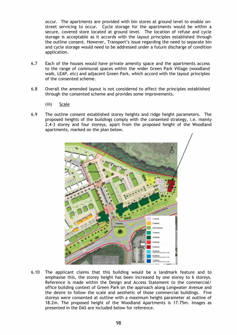
occur. The apartments are provided with bin stores at ground level to enable on-street servicing to occur. Cycle storage for the apartments would be within a secure, covered store located at ground level. The location of refuse and cycle storage is acceptable as it accords with the layout principles established through the outline consent. However, Transport’s issue regarding the need to separate bin and cycle storage would need to be addressed under a future discharge of condition application.
6.7 Each of the houses would have private amenity space and the apartments access
to the range of communal spaces within the wider Green Park Village (woodland walk, LEAP, etc) and adjacent Green Park, which accord with the layout principles of the consented scheme.
6.8 Overall the amended layout is not considered to affect the principles established
through the consented scheme and provides some improvements.
(iii) Scale 6.9 The outline consent established storey heights and ridge height parameters. The
proposed heights of the buildings comply with the consented strategy, i.e. mainly 2.4-3 storey and four storeys, apart from the proposed height of the Woodland apartments, marked on the plan below.
6.10 The applicant claims that this building would be a landmark feature and to
emphasise this, the storey height has been increased by one storey to 6 storeys. Reference is made within the Design and Access Statement to the commercial/ office building context of Green Park on the approach along Longwater Avenue and the desire to follow the scale and aesthetic of those commercial buildings. Five storeys were consented at outline with a maximum height parameter at outline of 18.2m. The proposed height of the Woodland Apartments is 17.75m. Images as presented in the DAS are included below for reference.
98
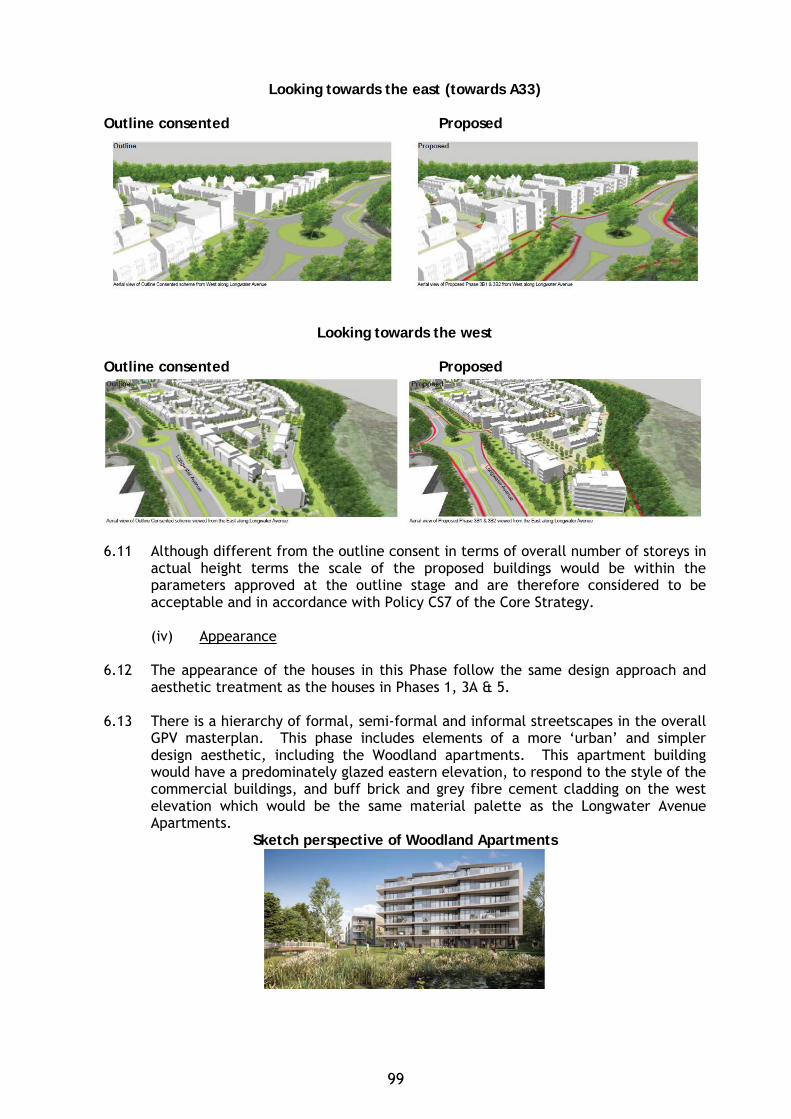
Looking towards the east (towards A33)
Outline consented Proposed
Looking towards the west
Outline consented Proposed
6.11 Although different from the outline consent in terms of overall number of storeys in
actual height terms the scale of the proposed buildings would be within the parameters approved at the outline stage and are therefore considered to be acceptable and in accordance with Policy CS7 of the Core Strategy.
(iv) Appearance
6.12 The appearance of the houses in this Phase follow the same design approach and
aesthetic treatment as the houses in Phases 1, 3A & 5. 6.13 There is a hierarchy of formal, semi-formal and informal streetscapes in the overall
GPV masterplan. This phase includes elements of a more ‘urban’ and simpler design aesthetic, including the Woodland apartments. This apartment building would have a predominately glazed eastern elevation, to respond to the style of the commercial buildings, and buff brick and grey fibre cement cladding on the west elevation which would be the same material palette as the Longwater Avenue Apartments.
Sketch perspective of Woodland Apartments
99
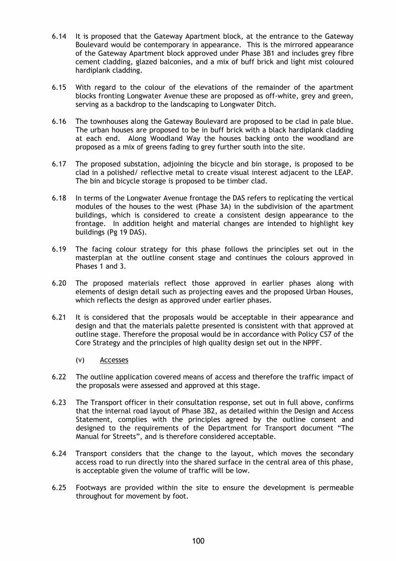
6.14 It is proposed that the Gateway Apartment block, at the entrance to the Gateway Boulevard would be contemporary in appearance. This is the mirrored appearance of the Gateway Apartment block approved under Phase 3B1 and includes grey fibre cement cladding, glazed balconies, and a mix of buff brick and light mist coloured hardiplank cladding.
6.15 With regard to the colour of the elevations of the remainder of the apartment
blocks fronting Longwater Avenue these are proposed as off-white, grey and green, serving as a backdrop to the landscaping to Longwater Ditch.
6.16 The townhouses along the Gateway Boulevard are proposed to be clad in pale blue.
The urban houses are proposed to be in buff brick with a black hardiplank cladding at each end. Along Woodland Way the houses backing onto the woodland are proposed as a mix of greens fading to grey further south into the site.
6.17 The proposed substation, adjoining the bicycle and bin storage, is proposed to be
clad in a polished/ reflective metal to create visual interest adjacent to the LEAP. The bin and bicycle storage is proposed to be timber clad.
6.18 In terms of the Longwater Avenue frontage the DAS refers to replicating the vertical
modules of the houses to the west (Phase 3A) in the subdivision of the apartment buildings, which is considered to create a consistent design appearance to the frontage. In addition height and material changes are intended to highlight key buildings (Pg 19 DAS).
6.19 The facing colour strategy for this phase follows the principles set out in the
masterplan at the outline consent stage and continues the colours approved in Phases 1 and 3.
6.20 The proposed materials reflect those approved in earlier phases along with
elements of design detail such as projecting eaves and the proposed Urban Houses, which reflects the design as approved under earlier phases.
6.21 It is considered that the proposals would be acceptable in their appearance and
design and that the materials palette presented is consistent with that approved at outline stage. Therefore the proposal would be in accordance with Policy CS7 of the Core Strategy and the principles of high quality design set out in the NPPF.
(v) Accesses
6.22 The outline application covered means of access and therefore the traffic impact of
the proposals were assessed and approved at this stage. 6.23 The Transport officer in their consultation response, set out in full above, confirms
that the internal road layout of Phase 3B2, as detailed within the Design and Access Statement, complies with the principles agreed by the outline consent and designed to the requirements of the Department for Transport document “The Manual for Streets”, and is therefore considered acceptable.
6.24 Transport considers that the change to the layout, which moves the secondary
access road to run directly into the shared surface in the central area of this phase, is acceptable given the volume of traffic will be low.
6.25 Footways are provided within the site to ensure the development is permeable
throughout for movement by foot.
100
6.26 Although the overall parking provision complies with what was approved at outline consent an issue was raised regarding the level of visitor parking for this phase. Subsequent to confirmation from the applicant that the overall visitor numbers across the GPV development will accord with the consented level Transport confirmed acceptance of the proposed number for this phase.
6.27 The majority of the parking would be to the front of units or within courtyards. All
dwellings would be provided with a rear gate for convenient access to the allocated parking spaces. Proposed house Types D1 and D3 would have garages and a condition is recommended to ensure that these would be kept available for the parking of vehicles.
6.28 Although the parking bays and parking areas are generally acceptable there are a
few that Transport have advised where there could be improvement, but that this could be dealt with via the discharge of condition (as attached to the original outline consent).
6.29 Cycle storage would meet adopted standards and would either be within sheds for the houses or storage areas for the apartments. However, Transport has identified that shared bin and cycle storage, as proposed, would not be acceptable, but that this could be addressed via the discharge of condition (as attached to the original consent). 6.30 The refuse storage areas would accord with the principles established at the outline
stage, and the applicant has confirmed that the relevant pull distances for larger waste containers has been agreed by RBC for an earlier approved phase (no. 5).
6.31 Transport has confirmed that the overall parking numbers, accesses into and the
internal layout would be acceptable subject to the condition in the recommendation above. Transport related conditions on the outline consent would also still apply.
(vi) Landscaping/ open space
6.32 The overall landscape strategy proposed for this phase is to provide a high quality
setting for the built form and the existing landscape along the Longwater Ditch as well as to complement the adjacent Phase 3A. The Masterplan for this phase includes the aim of creating an attractive visual experience along Longwater Avenue. This would be through the inclusion of a large feature pond to the east, similar to that within Green Park Business Park, along with the retention and enhancement of the existing ditch.
6.33 The proposal includes the retention of existing large, robust group of trees, some
selective removal, and enhancements with tree planting along the ditch as well as wetland planting and wildflower grasses. Planting is proposed along building facades which would provide a defensible boundary between private rooms and public areas.
6.34 With regard to the hard landscape strategy this includes a range of robust materials
specific to types of location within the phase, i.e. primary vehicular routes and pathways, parking bays and secondary roadways, private pathways and the central mews space.
6.35 The Natural Environment Officer identified a number of issues with the original soft
landscape submission, as set out in detail in section 4 above and the following paragraphs sets out the responses.
101
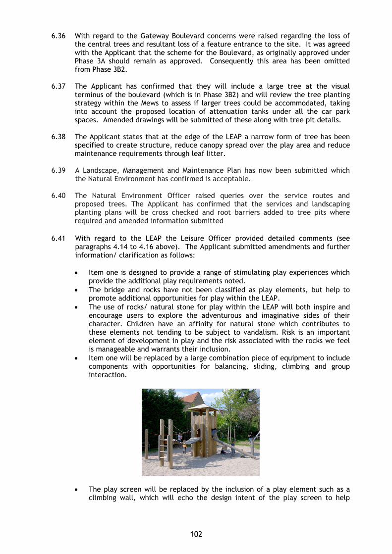
6.36 With regard to the Gateway Boulevard concerns were raised regarding the loss of the central trees and resultant loss of a feature entrance to the site. It was agreed with the Applicant that the scheme for the Boulevard, as originally approved under Phase 3A should remain as approved. Consequently this area has been omitted from Phase 3B2.
6.37 The Applicant has confirmed that they will include a large tree at the visual
terminus of the boulevard (which is in Phase 3B2) and will review the tree planting strategy within the Mews to assess if larger trees could be accommodated, taking into account the proposed location of attenuation tanks under all the car park spaces. Amended drawings will be submitted of these along with tree pit details.
6.38 The Applicant states that at the edge of the LEAP a narrow form of tree has been
specified to create structure, reduce canopy spread over the play area and reduce maintenance requirements through leaf litter.
6.39 A Landscape, Management and Maintenance Plan has now been submitted which the Natural Environment has confirmed is acceptable. 6.40 The Natural Environment Officer raised queries over the service routes and
proposed trees. The Applicant has confirmed that the services and landscaping planting plans will be cross checked and root barriers added to tree pits where required and amended information submitted
6.41 With regard to the LEAP the Leisure Officer provided detailed comments (see
paragraphs 4.14 to 4.16 above). The Applicant submitted amendments and further information/ clarification as follows:
• Item one is designed to provide a range of stimulating play experiences which
provide the additional play requirements noted. • The bridge and rocks have not been classified as play elements, but help to
promote additional opportunities for play within the LEAP. • The use of rocks/ natural stone for play within the LEAP will both inspire and
encourage users to explore the adventurous and imaginative sides of their character. Children have an affinity for natural stone which contributes to these elements not tending to be subject to vandalism. Risk is an important element of development in play and the risk associated with the rocks we feel is manageable and warrants their inclusion.
• Item one will be replaced by a large combination piece of equipment to include components with opportunities for balancing, sliding, climbing and group interaction.
• The play screen will be replaced by the inclusion of a play element such as a climbing wall, which will echo the design intent of the play screen to help
102
define space but will offer greater challenges to users with varying degrees of difficulty.
• The revolving disc will be replaced by alternative equipment (e.g. spinning roundabout/disc).
• The layout of the LEAP has integrated two seats which have been positioned to afford good passive surveillance through the dedicated formal play area.
• The area will include provision for a litter bin and signage, the wording for the latter to be provided to the Local Authority for approval prior to installation.
• The dedicated play area is 32m to the south and 23m from built form to the east respectively. The area illustrated to the is proposed for informal activities and the 20m buffer line from the built form ties into the alignment of planting upon the eastern boundary and as such no play activities will be within this buffer zone.
• The layout of the LEAP is defined by the use of planting with hedgerows strategically positioned to prevent conflict with road and primary footpath users.
• Maintenance vehicles will access the LEAP via the two parking spaces adjacent to the southern boundary of the play area.
• The safety surfacing will be rubber crumb within the fall zone specific to each piece of play and play gravel elsewhere.
• The LEAP incorporates the areas of lawn beyond the dedicated play facilities which is designed to contrast to the formal play area and meet the 400Sq/m LEAP requirements.
Leisure has confirmed that the amended detailed scheme for the LEAP is acceptable. 6.42 Subject to the receipt of suitably amended plans the Natural Environment Officer
has confirmed that the proposed amendments are acceptable. Therefore, the materials and the landscaping approach are considered to be consistent with those established through the outline approval. Landscaping conditions on the outline consent will still need to be met, and this is recommended as an informative.
(vii) Infrastructure Provision (Section 106 and Community Infrastructure Levy)
Employment, Skills and Training 6.43 The original outline permission pre-dated the Council’s Employment, Skills and
Training SPD (2013) and it was not a material consideration at that time, and any conditions attached to a reserved matters decision must relate to those specific matters only.
6.44 However, the Applicant has confirmed that they operate their own programme of
training and apprenticeships and have a company-wide target to increase site-based apprenticeships and training. An informative is recommended regarding working with Reading UK CIC to develop a scheme specific ESP.
Community Infrastructure Levy (CIL) 6.45 As the outline planning permission was granted before the Council’s CIL
implementation this Reserved Matters application does not trigger liability to pay CIL.
(ix) Equality 6.46 In determining this application the Council is required to have regard to its
obligations under the Equality Act 2010. The key equalities protected characteristics include age, disability, gender, gender reassignment, marriage and
103
civil partnership, pregnancy and maternity, race, religion or belief, sexual orientation. The principle of the development was approved at outline stage and details being considered under this application relate specifically to the function and form of the building and the layout of the external space.
6.47 There is no indication or evidence (including from consultation on the current
application) that the protected groups have or will have different needs, experiences, issues and priorities in relation to this particular planning application. In terms of the key equalities protected characteristics it is considered there would be no significant adverse impacts as a result of the development.
7. CONCLUSION 7.1 In conclusion the development of this site as detailed on the submitted plans and
information is considered to be of an acceptable appearance and scale, and layout and design and accords with relevant adopted policies. Further details will be submitted to address the landscape comments and will be reported within an update report. Subject to the receipt of further amended information and details of clarification, it is recommended that this reserved matters application be granted subject to conditions.
Case Officer: Alison Amoah
104
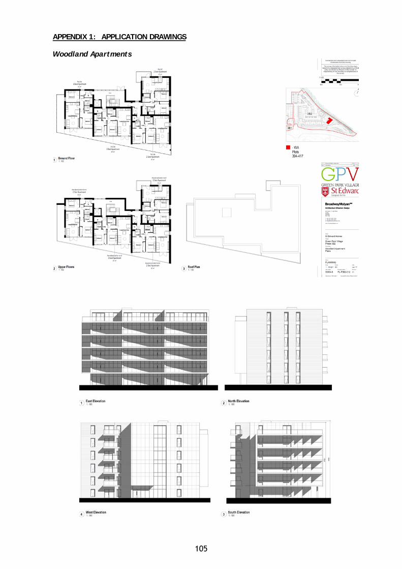
APPENDIX 1: APPLICATION DRAWINGS Woodland Apartments
105
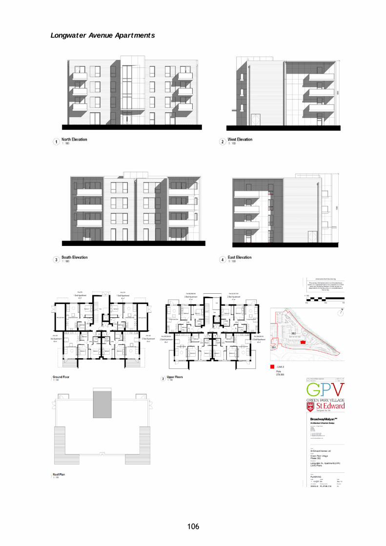
Longwater Avenue Apartments
106
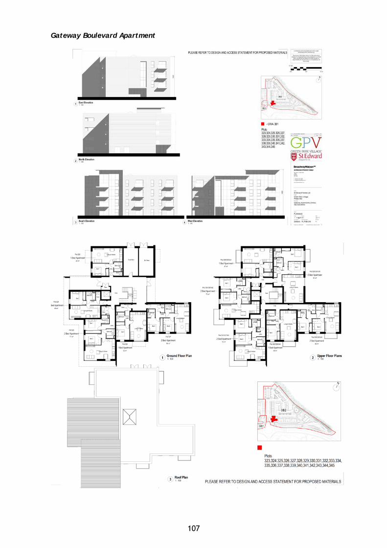
Gateway Boulevard Apartment
107
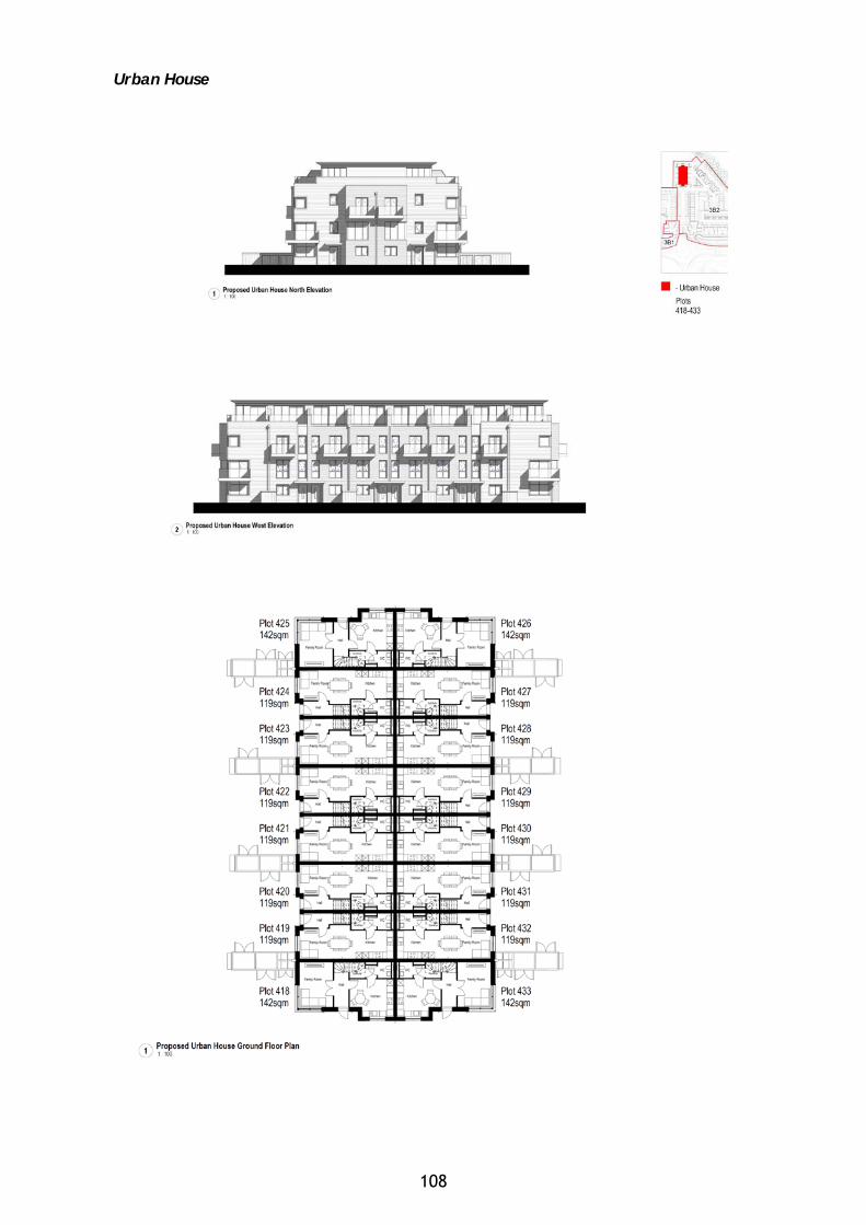
Urban House
108
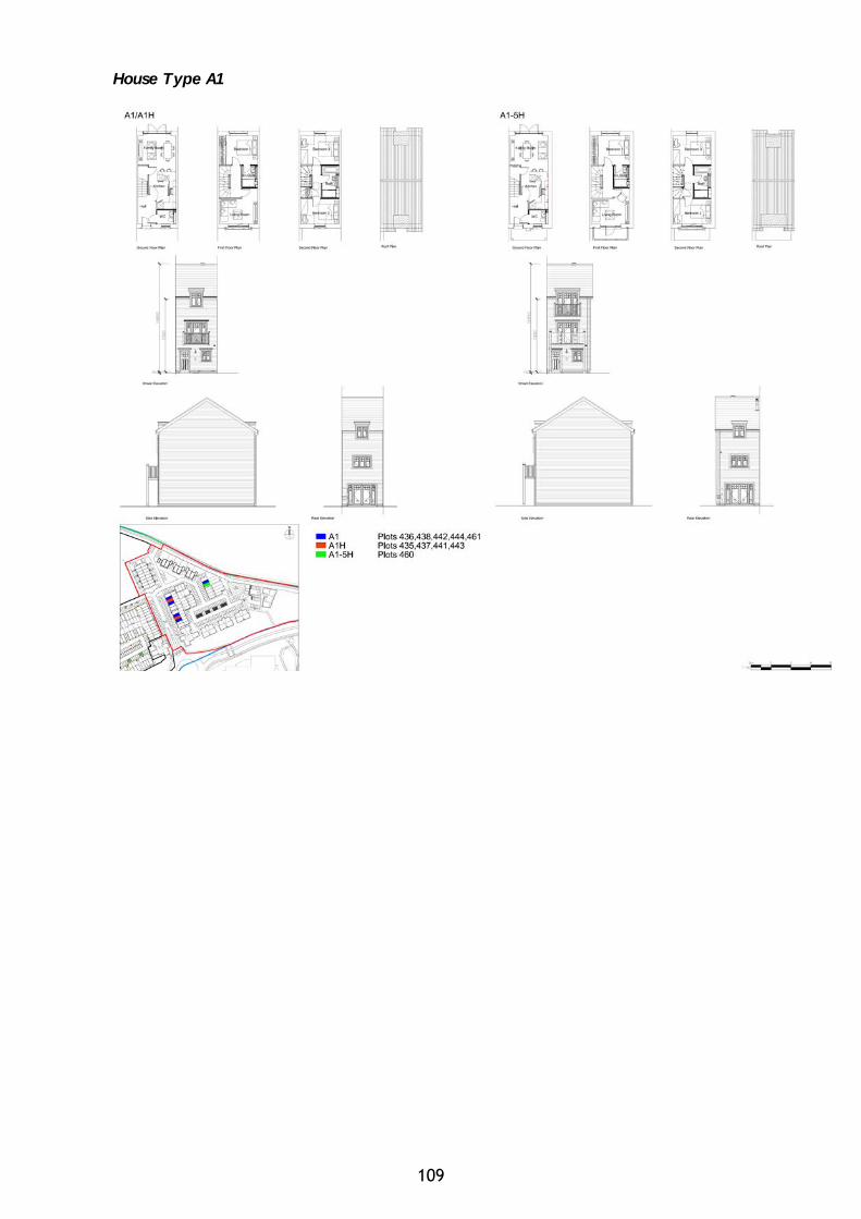
House Type A1
109
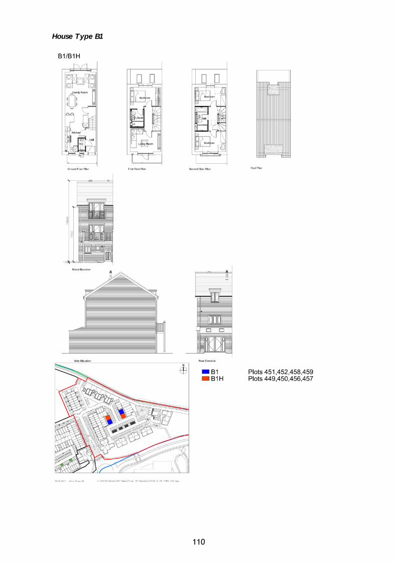
House Type B1
110
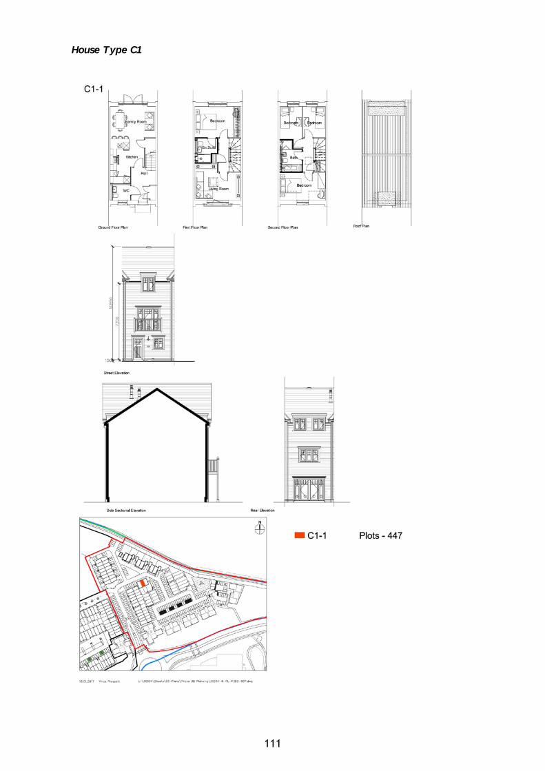
House Type C1
111
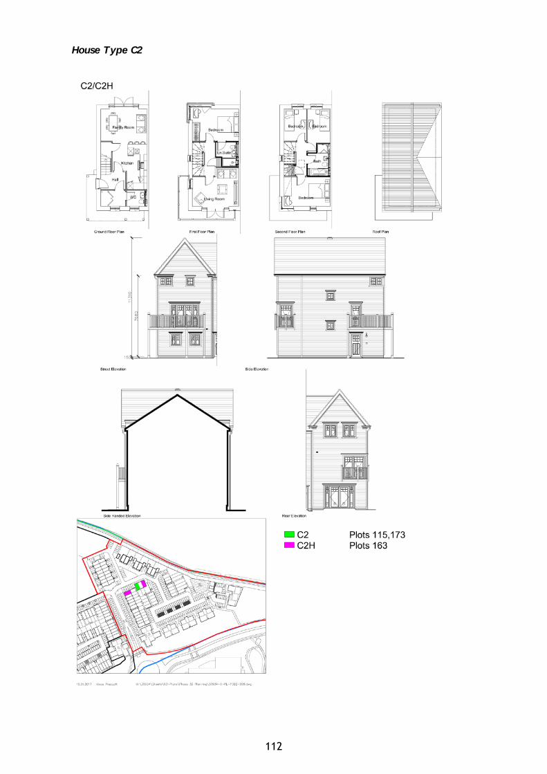
House Type C2
112
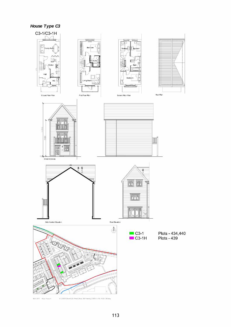
House Type C3
113
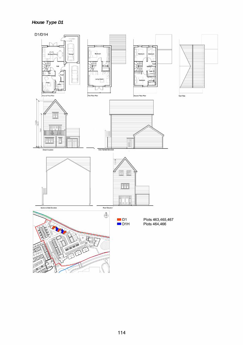
House Type D1
114
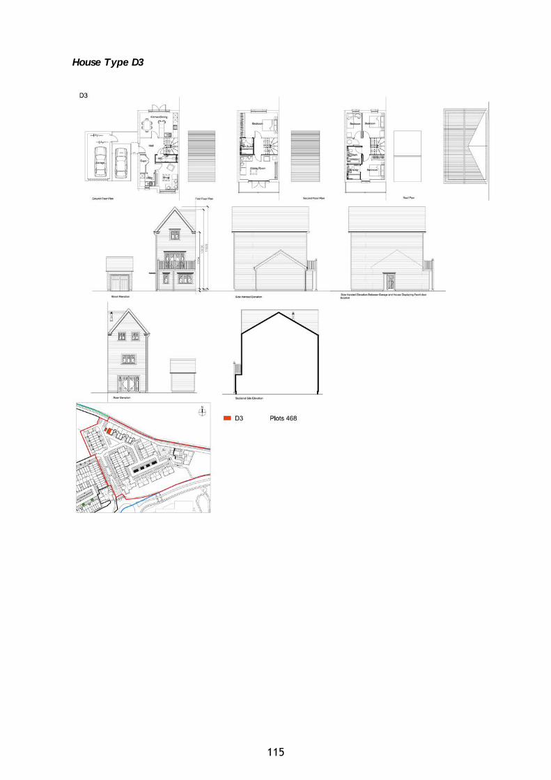
House Type D3
115

Street Scenes
116