Embed Size (px)
Citation preview

15/05/2017 1
This report was produced by Chichester and District Archaeology Society and is confidential. No part may be published without permission of the Society
Chichester and District Archaeology Society
Geophysical Survey
Aldwick Village Green March 2017
Photo: CDAS 21st March 2017
CDAS volunteers at work
Trevor Davies and Mike Kallaway

15/05/2017 2
This report was produced by Chichester and District Archaeology Society and is confidential. No part may be published without permission of the Society
Summary
Aldwick Village Green is located about 700m from the shoreline on the eastern side of Aldwick. It was the site of a barracks during Napoleonic times and has remained largely undeveloped since then. Arun District Council gave permission for CDAS to conduct a resistivity survey covering the whole of the Green. A number of features including the possible sites of military huts where identified. From this limited evidence it has been possible to speculate on the full layout of the military camp.
Background
CDAS were approached by Ken Hiscock, Chairman Aldwick Green Conservation Society, to
make a survey of the Green. A number of undulations in the Green had gradually been
getting deeper and there was a desire to fill them in. Carl Smith from Arun District Council,
who own the Green, suggested that a survey be made first and nominated CDAS as a
possible partner.
Aldwick Village Green was the site of former Barracks built during Napoleonic times used as
a garrison for coastal defence. A Painting, now in the British Library, shows a tented camp
in 1795 which was subsequently converted into a barracks in 1803. The original camp was
occupied by the Radnor Militia.
The 1813 OS Map, probable survey date 1809, shows the barracks clearly with a number of
buildings/huts covering an area slightly larger than the current Village Green. The likely
construction for the majority of huts would have been wooden superstructure on simple brick
footings. There was likely to be a Magazine which would have been brick throughout and
maybe built on more substantial footings.
In 1809 the barracks was recorded as housing 758 troops, so was a substantial site. As the
threat of invasion by Napoleon faded the barracks gradually fell into disuse, acting as a
possible military hospital before finally being sold off in lots around 1812. The barracks does
not appear on the 1879 Ordnance Survey Map, where the Green is shown in its current
layout in which it also appears in later maps.
Since then site has remained undeveloped so it is possible that the hut footings are still in
place. The Environment Agency’s 50cm LiDAR indicated the possible location of at least
one of these.
Based on the history of the site and the LiDAR data CDAS agreed with Arun District Council
and The Aldwick Green Conservation Society to do a resistivity of the full site.
1. Site Access/ Health and Safety
The Health and Safety Risk Assessment (Appendix 1) was prepared prior to undertaking the survey.

15/05/2017 3
This report was produced by Chichester and District Archaeology Society and is confidential. No part may be published without permission of the Society
2. Method
These surveys utilised the following equipment:
1. Geoscan RM15 D Resistivity meter serial number 4425 that CDAS was able to purchase as a result of generous donations for this purpose from the Chichester District Council Coastal Pathfinder Project and the Chichester City Council.
2. Geoscan RM15 D Resistivity meter serial number 4328 acquired on long term loan from the Chichester District Council at the conclusion of the City Walls project.
3. Electronic Theodolite. Previously purchased by CDAS as the result of a generous grant from the Chichester Harbour Conservancy.
A 30m grid was laid out on the site using a Water trough and manhole as reference points. The water trough was at the northern most end of the site with the manhole located 72m to the South.
The corners of the grid were marked with canes (our usual practice) and also small white biodegradable tent pegs driven in flush with the ground. At the end of the first day’s work, the canes were removed, but the tent pegs remained. It proved relatively quick for two team members armed with tapes to find the tent pegs and replace the canes on the second day.
The sequence in which the grids were surveyed was planned so that at all times the static probes and the machines were at least 40 metres apart.
The data collected were downloaded to a laptop computer (Steatite model R15D) loaded with the Geoplot 3 program supplied by Geoscan Ltd. Subsequent data processing was carried out using this computer and software. The images were transferred onto another computer for ease of report writing and where necessary, the images were annotated using Adobe Photoshop elements 11.
We had planned to load the survey image into QGIS so that we could tie the results to features seen on LiDAR and thereby geo-reference the survey results. However the two features we had chosen as our base points for the grid, the water trough and manhole did not show up clearly on the LiDAR. In hindsight we could have taken measurements relative to our grid of other features that showed up clearly on the LiDAR and used those as geo-reference points for QGIS. In future, when planning a survey, it would be best to select a number of features on LiDAR which we can tie into the survey grid.
Volunteer Participation
CDAS members worked on the survey during 21st and 22nd March 2017. 14 CDAS members participated in the survey and provided a total of 17 man days of effort.

15/05/2017 4
This report was produced by Chichester and District Archaeology Society and is confidential. No part may be published without permission of the Society
Survey Results and Interpretation
Figure 1. Plot of the survey results superimposed on a Google earth image of Aldwick
Green.
Figure 1 shows the results we obtained during the survey.
This figure shows the features that are visible on the ground today, staring from the top of
the figure and moving clockwise:
The dips at the north end of the Green show paler because they are damper than the
surrounding area.
The location of the circular bench
The pipeline running to the water trough
A dry area caused by the tree canopy
There is a very solid response in the middle of the image; responses of this clarity
would normally be a masonry structure.
North and south of the solid response mentioned above are paler responses. These
may not be quite in a straight line and could be the foundations of an earlier path.

15/05/2017 5
This report was produced by Chichester and District Archaeology Society and is confidential. No part may be published without permission of the Society
There is a further response at an acute angle to the response discussed above which
terminates in a darker area, which could be another path.
The location of the manhole has been plotted
The other responses are muted. In part this is because any responses that we could
reasonably describe as “walls” are parallel or at right angles to the line of the survey. For
best results the line of the survey should be at approximately 45 degrees to the major walls.
The responses are so pale that the regular features we can see are likely to be robbed out
foundation trenches. During the late Georgian period, foundations for even permanent
houses were not deep by present day standards, and in a temporary wartime camp such as
this, they were likely to be minimal.
Figure 2. Layout of Aldwick Barracks shown on 1813 map, probable survey date 1809
Figure 2 shows the depiction of the Aldwick Barracks in an Ordnance Survey map of 1813.
There appear to be 11 huts most spaced regularly. At this scale, this depiction should be
taken as an indicative hut layout rather than a completely accurate one.
Figure 3 shows an analysis of the Environmental Agency LiDAR. For this area the LiDAR
survey was done to 50cm resolution. It shows a flat rectangular area that coincides with
one of the more marked responses on the resistivity survey.

15/05/2017 6
This report was produced by Chichester and District Archaeology Society and is confidential. No part may be published without permission of the Society
Figure 3. Environment Agency LiDAR survey
Using our conclusions from the LiDAR survey and the resistivity survey, we have concluded
that the huts were approximately 8m by 16m. Figure 4 shows those huts that can be
recognised in the resistivity survey.
The analytical process has been as follows:
Create a “standard” sized hut using the best of the responses.
Compare this to the expected hut size. The “standard” hut is 8m by 16m. We
believe that there were 11 or 12 huts for 730 men (Figure 2). Assuming officers
were accommodated elsewhere, this is 60 men to a hut. This would give each man
2.1 square metres – inadequate if there were single beds, but adequate if there were
tiered bunks.
Using the “known” huts as a basis, locate the other huts over partial responses,
applying symmetry were possible on the assumption that the military mind was at
work. This has resulted in the layout proposed in figure 5. It should be
emphasised that there is not full survey evidence for the hut locations in pale blue
and it is speculation on our part.

15/05/2017 7
This report was produced by Chichester and District Archaeology Society and is confidential. No part may be published without permission of the Society
Figure 4. Proposed layout of the hut encampment
Figure 5. Speculative hut layout
15/05/2017 8
This report was produced by Chichester and District Archaeology Society and is confidential. No part may be published without permission of the Society
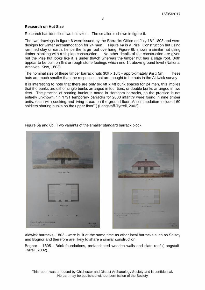
Research on Hut Size
Research has identified two hut sizes. The smaller is shown in figure 6.
The two drawings in figure 6 were issued by the Barracks Office on July 18th 1803 and were designs for winter accommodation for 24 men. Figure 6a is a Pize- Construction hut using rammed clay or earth, hence the large roof overhang. Figure 6b shows a similar hut using timber planking with a shiplap construction. No other details of the construction are given but the Pize hut looks like it is under thatch whereas the timber hut has a slate roof. Both appear to be built on flint or rough stone footings which end 1ft above ground level (National Archives, Kew, 1803).
The nominal size of these timber barrack huts 30ft x 16ft – approximately 9m x 5m. These huts are much smaller than the responses that are thought to be huts in the Aldwick survey
It is interesting to note that there are only six 6ft x 4ft bunk spaces for 24 men, this implies that the bunks are either single bunks arranged in four tiers, or double bunks arranged in two tiers. The practice of sharing bunks is noted in Horsham barracks, so the practice is not entirely unknown. “In 1791 temporary barracks for 2000 infantry were found in nine timber units, each with cooking and living areas on the ground floor. Accommodation included 60 soldiers sharing bunks on the upper floor” ( (Longstaff-Tyrrell, 2002).
Figure 6a and 6b. Two variants of the smaller standard barrack block
Aldwick barracks- 1803 - were built at the same time as other local barracks such as Selsey and Bognor and therefore are likely to share a similar construction.
Bognor – 1805 - Brick foundations, prefabricated wooden walls and slate roof (Longstaff-Tyrrell, 2002).

15/05/2017 9
This report was produced by Chichester and District Archaeology Society and is confidential. No part may be published without permission of the Society
Selsey – 1798 to 1803 – “modest” barracks for 16 officers, 330 men, a hospital for 50 men and stables for 20 horses. No information given about construction details (Longstaff-Tyrrell, 2002)
However, the sale particulars for Selsey were more informative and referred to the barracks being “composed of the very best oak and Memel (Baltic) timber, are slated on boards, the hips and ridges leaded and the whole built on brick footings except the magazine, the women’s hut and the washing house, which are brick and tiled.” (Anon., 1812). It is therefore reasonable to assume that the Aldwick huts were wooden, probably with a slate roof and had brick or even flint footings. Since Aldwick accommodated over twice as many men as the Selsey barracks, it could be expected to include examples of the latter three structures.
When considering other examples of Napoleonic barracks such as that at Berry Head, Brixham, Devon (Armitage, 2007), it appears that the above 24 man hut could have been a basic “building block” for other, larger structures elsewhere, so assemblies of these basic units should not be ruled out in the Aldwick case.
Figure 7. Providence Chapel, Charlwood
Providence Chapel Listed Grade II* shown in figure 7 is vacant and on the Heritage at Risk register. It was purchased by the Providence Chapel Charlwood Trust with the aim of renovating and preserving this historic building for use by the community. It stands on Chapel Lane to the north of the village.
It was built in Horsham in c.1797 as a barracks and officers mess for troops assembled to repel an invasion by Napoleon, and has an interesting military history as the first home of the Green Jackets regiment. In 1815 it was purchased by a local farmer and re-erected in Charlwood as a non-denominational, later Baptist, chapel.
Externally the chapel remains unchanged since first built in 1797 and, as Pevsner commented, could have come straight from the American mid-west. Internally the chapel

15/05/2017 10
This report was produced by Chichester and District Archaeology Society and is confidential. No part may be published without permission of the Society
remains much as in 1815, a simple non-conformist village chapel. Much of the original glass remains having been protected by wooden shutters (Anon., n.d.).
This structure has been measured using Google earth as 19m x 10m. Allowing for the large overhang along one side the footprint is nearer 19m x 9m. These dimensions are much closer to those proposed for the Aldwick huts. Each side is approximately twice the dimensions of the standard 24man barrack huts prescribed by the Barracks Office - providing accommodation for 4 times as many men. The Aldwick huts could have been based on a 4 modules of the standard hut.
Acknowledgements
The authors acknowledge the help and encouragement received from the Aldwick Green
Conservation Society – particularly Ken and Sandy Hiscock.
Thanks are also due to Carl Smith, Community Parks Officer, Greenspace & Emergency
Planning Arun District Council who gave permission for the survey
The authors also acknowledge the research of military huts from the Napoleonic era
undertaken by Brian Tomkinson.
Opportunities for further investigation
1. Determine the exact location of the path that was removed from the grass area in the
early days of Aldwick Green’s refurbishment.
2. Determine from Southern Water location of pipes connected to the manhole on the
Eastern side of the Green.
3. Further research on possible hut size and layout
4. Discover how WW11 impacted the site – this might explain the dark response in the
centre of the green.
5. Modify conclusions accordingly.
Bibliography
Anon., 1812. Hampshire Telegraph, 10 August.
Anon., n.d. The Charlwood Society. [Online]
Available at: http://www.charlwoodsociety.co.uk/providence-chapel.php.
[Accessed 10th April 2017].
Armitage, P. L., 2007. Summary of an investigation into the Napoleonic infantry barracks at
Berry Head, Brixham (Torbay, UK0. [Online]
Available at: http://www.brixhamheritage.org.uk/archaeology/Berry_Head_Barracks.pdf
[Accessed 2017].
Longstaff-Tyrrell, P., 2002. Barracks to Bunkers: 250 Years of Military Activity in Sussex.
Stroud: The History Press Ltd.
National Archives, Kew, 1803. Drawings of huts proposed as winter accommodation for
troops on the Kent and Sussex coast, MPH 1/822 1-2, s.l.: s.n.

15/05/2017 11
This report was produced by Chichester and District Archaeology Society and is confidential. No part may be published without permission of the Society
APPENDIX 1 CHICHESTER AND DISTRICT ARCHAEOLOGY SOCIETY - RISK ASSESSMENT FORM
SITE NAME: Aldwick Village Green SITE CODE: AW17 ASSESSMENT BY: Mike Kallaway
DATE: 30/01/2017 PAGE 1 OF 2
ACTIVITY: Surveying (week commencing 20th March 2017) No. of people present: (Min 2 / Max 15 at any one time)
HAZARD IDENTIFICATION
HAZARDS IDENTIFIED People at risk (tick) Likelihood of injury (tick)
NOTES ASSESSED
BY Volunteers* Public Probable Possible Remote
1. Beware ticks From deer – can cause Lymes disease
2. Avoid leptospiosis An infectious disease that affects
humans & animals
3. Exposure to sun, wind and rain No shelter available on site
4. Rough ground Around the edges of the Green
5. Insect bites
ACTION PLAN
Hazard
No.
MEASURES REQUIRED TO REDUCE RISK TO
ACCEPTABLE LEVEL NOTES
All measures in place.
Signed/dated
by Site Supervisor
1 Check for skin for ticks
2. Wash hands before eating
3. Volunteers advised to bring and use suntan cream and drink plenty of fluid. Use
of hats and windproof jackets advised
4. Boots to be worn where possible
5. First Aid kit available
15/05/2017 12
This report was produced by Chichester and District Archaeology Society and is confidential. No part may be published without permission of the Society
CHICHESTER AND DISTRICT ARCHAEOLOGY SOCIETY - RISK ASSESSMENT FORM
SITE NAME: Aldwick Village Green SITE CODE: AW17 ASSESSMENT BY: Mike Kallaway
DATE: 30/01/2017 PAGE 2 OF 2
ACTIVITY: Surveying (week commencing 20th March 2017) No. of people present: (Min 2 / Max 15 at any one time)
HAZARD IDENTIFICATION
HAZARDS IDENTIFIED People at risk (tick) Likelihood of injury (tick)
NOTES ASSESSED BY Volunteers* Public Probable Possible Remote
1. Sharp points on resistivity equipment
2. Busy roads at the edge of the Green Make volunteers aware
3. Stream and ditch at eastern edge of the
Green Make volunteers aware
4 Sharp flints in the ground Less of an issue here
5. Manual handling
6. Trip Hazard Try to keep public away
ACTION PLAN
Hazard
No.
MEASURES REQUIRED TO REDUCE RISK TO
ACCEPTABLE LEVEL NOTES
All measures in place.
Signed/dated
by Site Supervisor
1. Boots to be worn when using this equipment It is not planned to use magnetometer
2. Volunteers advised. First Aid kit, available
3. Volunteers advised. First Aid kit available
4. Volunteers advised. First Aid kit available
5. Volunteers reminded of correct lifting procedure. Warning against
becoming tired.
Ensure those carrying the equipment are rotated
regularly.
6. Use canes and hazard tapes as necessary Intercept members of the public if necessary


![CDAS: A Crowdsourcing Data Analytics System · 2012-07-03 · framework designed to support the deployment of various crowd-sourcing applications. Thecore part of CDAS isa ... [19]](https://img.pdfslide.us/doc/110x75/5fb44d1ded64e304a9534263/cdas-a-crowdsourcing-data-analytics-system-2012-07-03-framework-designed-to-support.jpg)