Embed Size (px)
Citation preview
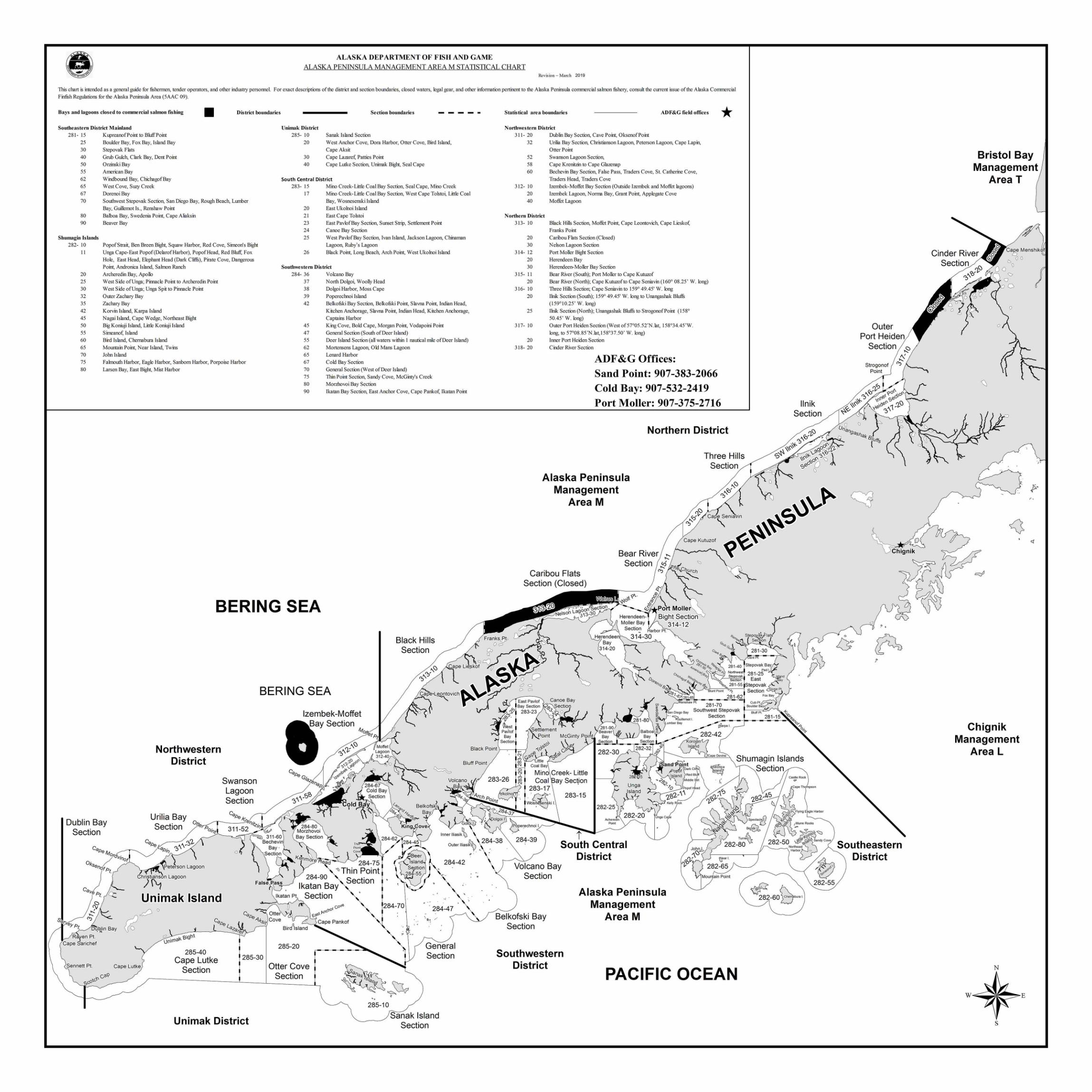
ALASKA DEPARTMENT OF FISH AND GAME ALASKA PENINSULA MANAGEMENT AREA M STATISTICAL CHART
Revision - March 2019
This chart is intended as a general guide for fishermen, tender operators, and other industry personnel. For exact descriptions of the district and section boundaries, closed waters, legal gear, and other infonnation pertinent to the Alaska Peninsula comrrercial sabnon fishery, consult the current issue of the Alaska Corrunercial Finfish Regulations for the Alaska Peninsula Area (5AAC 09).
Bays and lagoons closed to commercial salmon fishing District boundaries Section boundaries Southeastern District Mainland
281- 15 25 30
40
50
55 62
65 67
70
80
90
Shumagin Islands 282- 10
II
20
25
30
32
35
42
45
50
55
60
65
70
75
80
Kupreanof Point to Bluff Point Boukler Bay, Fox Bay, Island Bay Stepovak Flats
Grnb Gulch, Clark Bay, Dent Point
Orzinski Bay
American Bay Windbound Bay, ChiehagofBay
West Cove, Suzy Creek Dorenoi Bay
Southwest Stepovak Section, San Diego Bay, Rough Beach, LWTIDer
Bay, Guilk:nx,t Is. , Renshaw Point Balboa Bay, Swedenia Point, Cape Aliaksin Beaver Bay
PopofStrait, Ben Breen Bight, Squaw Harbor, Red Cove, Simeon's Bight Unga Cape-East Popof(DelarofHarbor), PopofHead, Red Bluff: Fox Hole, East Head, Elephant Head (Dark Cliffi), Pirate Cove, Dangerous Point, Andronica Island, Sabnon Ranch Archeredin Bay, Apolb West Side of Unga; Pinnacle Point to Archeredin Point West Side of Unga; Unga Spit to Pinnacle Point Outer Zachary Bay Zachary Bay
Korvin Island, Karpa Island Nagai Island, Cape Wedge, N01theast Bight Big Koniuji Island, Little Koniuji Island Sirreanof, Island Bn·d Island, Chernabura Island
Mountain Point, Near Island, Twins John Island
Fabnouth Harbor, Eagle Harbor, Sanborn Harbor, Porpoise Harbor Larsen Bay, East Bight, Mist Harbor
Unimak District 285- IO Sanak Island Section
20 West Anchor Cove, Dora Harbor, Otter Cove, Bird Island, Cape Aksit
30 Cape Lazaref, Patties Point 40 Cape Lutke Section, Unimak Bight, Seal Cape
South Central District 283- 15 Mino Creek-Little Coal Bay Section, Seal Cape, Mino Creek
17 Mino Creek-Little Coal Bay Section, West Cape Tolsto~ Little Coal Bay, Wosnesenski Island
20 East Ukolnoi Island 2 1 East Cape Tolstoi 23 East Pavlof Bay Section, Sunset Strip, Settlement Point 24 Canoe Bay Section 25 West PavlofBay Section, Ivan Island, Jackson Lagoon, Chinaman
Lagoon, Ruby's Lagoon 26 Black Point, Long Beach, Arch Point, West Ukolnoi Island
Southwestern District 284- 36 Volcano Bay
37 N01th Dolgo~ Woolly Head 38 Dolgoi Harbor, Moss Cape 39 Poperechnoi Island 42 Belkofski Bay Section, Belkofski Point, Slavna Point, Indian Head,
Kitchen Anchorage, Slavna Point, Indian Head, Kitchen Anchorage, Captains Harbor
45 King Cove, Bold Cape, Morgan Point, Vodapoini Point 47 General Section (South of Deer Island) 55 Deer Island Section (all waters within I nautical mile of Deer Island) 62 M01tensens Lagoon, Old Mans Lagoon 65 Lenard Harbor 67 Cold Bay Section 70 General Section (West of Deer Island) 75 Thin Point Section, Sandy Cove, McGinty's Creek 80 Morzhovoi Bay Section 90 lkatan Bay Section, East Anchor Cove, Cape Pankof, Ikatan Point
Statistical area boundaries ADF&G field offices
Northwestern District * 3 11- 20
32
52
58
60
3 12- 10
20
40
Northern District 313- 10
20
30
3 14- 12
20
30
315- 11
20
316- 10
20
25
317- 10
20
318- 20
Dublin Bay Section, Cave Point, Oksenof Point Urilia Bay Section, Christianson Lagoon, Peterson Lagoon, Cape Lapin, Otter Point Swanson Lagoon Section, Cape Krenitzin to Cape Glazenap BecheVlll Bay Section, False Pass, Traders Cove, St. Cathe1ine Cove, Traders Head, Traders Cove Izembek-Moffet Bay Section (Outside lzembek and Moffet lagoons) Izembek Lagoon, Norma Bay, Grant Point, Applegate Cove Moffet Lagoon
Black Hills Section, Moffet Point, Cape Leontovich, Cape Lieskof, Franks Point Canbou Flats Section (Closed) Nels on Lagoon Section Port Moller Bight Section Herendeen Bay Herendeen-Moller Bay Section Bear River (South); Port Moller to Cape Kutuzof Bear River (North); Cape Kutuwf to Cape Scniavin ( I 60° 08 .25' W. long)
Three Hills Section; Cape SeTll8.vin to 159° 49.45' W. long llnik Section (South); 159° 49.45' W. long to Unangashak Bluffi;
( 159° 10.25' W. long)
llru1< Section (N01th); Unangashak Bluffs to StrogonofPoint (158°
50.45' W . long)
Outer Po1t Heiden Section (West of 57°05.52'N . lat, 158°34.45 'W. long, to 57°08.85'N .lat, 158°37.50' W. long)
Inner Po1t Heiden Section Cinder Rlver Section
ADF&G Offices: Sand Point: 907-383-2066 Cold Bay: 907-532-2419 Port Moller: 907-375-2716
Bristol Bay Management
Area T
Outer Port Heiden
Section
BERING SEA
BERING SEA
Northwestern District
Swanson Lagoon Section
Bluff Poi nt
283-26
Dublin Bay Section
Unimak Island
DybJin Bay
Rafen Pt. Cape S'arichef
~-'lks,· Cove I 0
285-40 Cape Lutke
Section
285-30
Bird Island
285-20
Otter Cove Section
284-75 "' Thin Point
284-90 Section lkatan Bay
Section co-J0
c'r-ot 'i:-~s\P,JI c,,"'
Cape Pankof
Sennett Pt. Cape Lutke
'.I\ C"Q scP'G
Northern District
Three Hills Section
Alaska Peninsula ,<::i
Management ":>"
to'
Area M
Cape Kutuzof ~ ~
Caribou Flats Section (Closed) ~
Black Hills Section
Chignik Management
Area L
283-15
t 284-39 South Central
District 284-42 Volcano Bay
Section
Alaska Peninsula &~ 282-60 o'abura I
284-70 Management . 284-47 Belkofski Bay Area M
Section !" •. ,
General Section Southwestern
District N
PACIFIC OCEAN w
285-10
Sanak Island Unimak District s Section