Embed Size (px)
Citation preview
Office of Coast Survey – Nautical Chart CatalogAlaska Index (AK)www.nauticalcharts.noaa.gov/catalog
Color Key for Charts
Type of Chart Scale Purpose
HARBOR CHARTS(outlined in red)
1:50,000 and larger For navigation and anchorage in harbors and small waterways.
SMALL-CRAFT CHARTS(outlined in green)
1:80,000 and larger Specially designed charts with small craft information.
COAST CHARTS(outlined in blue)
1:50,001 to 1:150,000 For coastwise navigation inside the offshore reefs and shoals, entering bays and harbors of considerable size, and navigating certain inland waterways.
GENERAL CHARTS(outlined in purple)
1:150,001 to 1:600,000 For use when a vessel’s course is offshore but when its position can be fixed by landmarks, lights, buoys, and characteristic soundings.
SAILING CHARTS(outlined in purple)
1:600,001 and smaller Plotting charts used for offshore sailing between distant coastal ports and for approaching the coast from the open ocean.
The scale of a chart is the ratio of a given distance on the chart to the actual distance that it represents on the earth. (Example: One unit of measurement on a 1:10,000 scale chart is equal to 10,000 of the same unit on the earth’s surface.) Large-scale charts show greater detail of a relatively small area. Small-scale charts show less detail, but cover a larger area. Certain hydrographic information may be omitted on smaller-scale charts. Mariners should always obtain the largest-scale coverage for near shore navigation.
June 2014
AK14
AK13 AK12 AK11
AK10
AK9
AK7
AK8
AK6
AK5 AK4
AK3
AK2
AK1
AK15
ALASKA
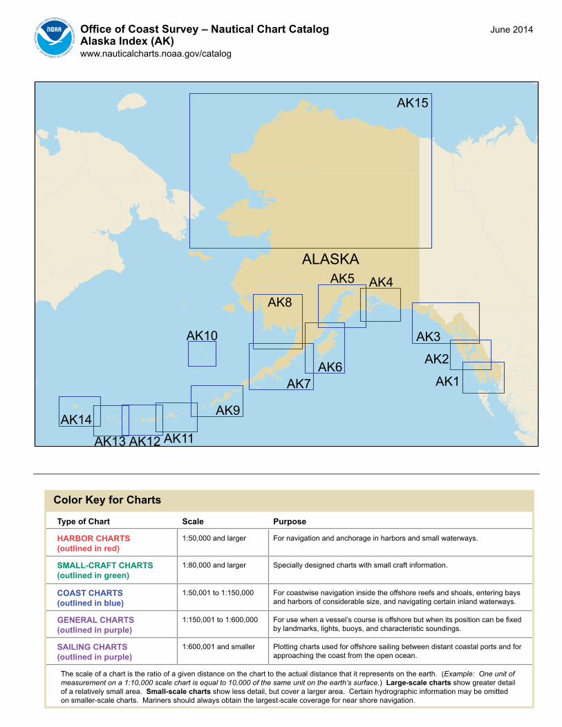
AK1Office of Coast Survey – Nautical Chart CatalogAlaska – Dixon Entrance to Coronation Islandwww.nauticalcharts.noaa.gov (see AK1T for chart table)
130°30'W
130°30'W
132°0'W
132°0'W
133°30'W
133°30'W
135°0'W
135°0'W
55°30'N 55°30'N
54°0'N 54°0'N
!
!
17409 17433
174081743217
431 17
435
17426
17436
17423
17423
17423
17423
17423
17401
17437
1742
8
17430
17407
17406
174051740
4
17402
17386
1740
3
17387
173831737917330
17331
17434 17434
17425
1742
4
1742
2
1738517382
1740
0
1742
0
Continued on AK2
Cape Knox
Langora Island
D I X O N E N T R A N C E
McINTYRE BAY Rose Point
GRAHAM ISLAND
Malacca Passage
Prince Rupert
DundasI
Portlan
d Inle
tP
OR
TLA
ND
CA
NA
L
DukeI
Coronation Island
Cape Decision
Cape Ommaney
Affleck C
anal
ShakanBay
Sea Otter Sound
Iphigenia Bay
Cape Ulitka
Cape Addington
BakerI
Cape Bartolome
Meares Passa
ge
Cape Lookout
Forrester Island
Dall Island
PR
INC
E O
F WH
ALE
S IS
LAN
D
CordovaBay
Cape Muzon
Klak
as In
let
CraigTrocadero Bay
Cle
vela
nd P
enin
sula
Behm
Can
al
Clarence Strait
Moira Sound
Cape Chacon
Behm C
anal
Chick
amin
R
Walker Cove
Wrangel I
Etolin I
Erne
st S
ound
UNITED STATESCANADA
GULFOF
ALASKA
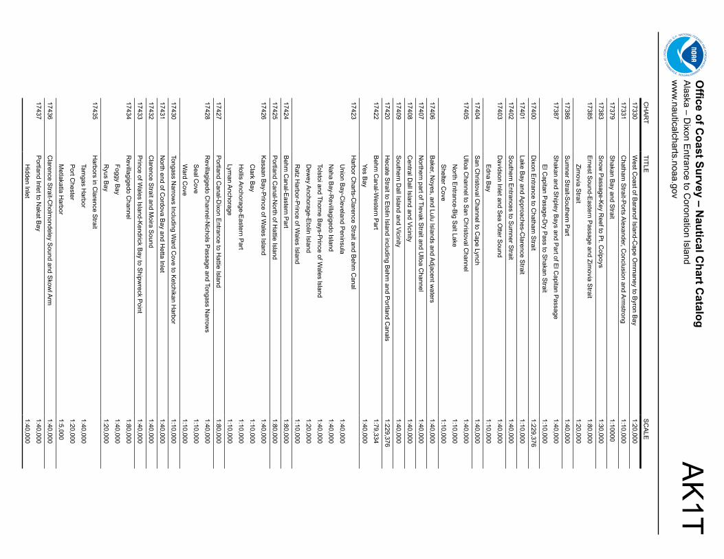
AK
1TO
ffice of Coast Survey – N
autical Chart C
atalogA
laska – Dixon E
ntrance to Coronation Island
ww
w.nauticalcharts.noaa.gov
CH
AR
TTITLE
SC
ALE
17330W
est Coast of B
aranof Island-Cape O
mm
aney to Byron B
ay1:20,000
17331C
hatham S
trait-Ports A
lexander, Conclusion and A
rmstrong
1:10,000
17379S
hakan Bay and S
trait1:10000
17383S
now P
assage-Key R
eef to Pt. C
olpoys1:30,000
17385E
rnest Sound-E
astern Passage and Zim
ovia Strait
1:80,000
Zimovia S
trait1:20,000
17386S
umner S
trait-Southern P
art1:40,000
17387S
hakan and Shipley B
ays and Part of E
l Capitan P
assage1:40,000
El C
apitan Pasage-D
ry Pass to S
hakan Strait
1:10,000
17400D
ixon Entrance to C
hatham S
trait1:229,376
17401Lake B
ay and Approaches-C
larence Strait
1:10,000
17402S
outhern Entrances to S
umner S
trait1:40,000
17403D
avidson Inlet and Sea O
tter Sound
1:40,000
Edna B
ay1:10,000
17404S
an Christoval C
hannel to Cape Lynch
1:40,000
17405U
lloa Channel to S
an Christoval C
hannel1:40,000
North E
ntrance-Big S
alt Lake1:10,000
Shelter C
ove1:10,000
17406B
aker, Noyes, and Lulu Islands and A
djacent waters
1:40,000
17407N
orthern part of Tlevak Strait and U
lloa Channel
1:40,000
17408C
entral Dall Island and Vicinity
1:40,000
17409S
outhern Dall Island and Vicinity
1:40,000
17420H
ecate Strait to E
tolin Island including Behm
and Portland C
anals1:229,376
17422B
ehm C
anal-Western P
art1:79,334
Yes Bay
1:40,000
17423H
arbor Charts-C
larence Strait and B
ehm C
anal
Union B
ay-Cleveland P
eninsula1:40,000
Naha B
ay-Revillagigedo Island
1:40,000
Tolstoi and Thorne Bays-P
rince of Wales lsland
1:40,000
Dew
ey Anchorage-E
tolin Island1:20,000
Ratz H
arbor-Prince of W
ales Island 1:10,000
17424B
ehm C
anal-Eastern P
art1:80,000
17425P
ortland Canal-N
orth of Hattie Island
1:80,000
17426K
asaan Bay-P
rince of Wales Island
1:40,000
Clark B
ay1:10,000
Hollis A
nchorage-Eastern P
art1:10,000
Lyman A
nchorage1:10,000
17427P
ortland Canal-D
ixon Entrance to H
attie Island1:80,000
17428R
evillagigedo Channel-N
ichols Passage and Tongass N
arrows
1:40,000
Seal C
ove1:10,000
Ward C
ove1:10,000
17430Tongass N
arrows Including W
ard Cove to K
etchikan Harbor
1:10,000
17431N
orth end of Cordova B
ay and Hetta Inlet
1:40,000
17432C
larence Strait and M
oira Sound
1:40,000
17433P
rince of Wales Island-K
endrick Bay to S
hipwreck P
oint1:40,000
17434R
evillagigedo Channel
1:80,000
Foggy Bay
1:40,000
Ryus B
ay1:20,000
17435H
arbors in Clarence S
trait
Tamgas H
arbor1:40,000
Port C
hester1:20,000
Metlakatla H
arbor1:5,000
17436C
larence Strait-C
holmondeley S
ound and Skow
l Arm
1:40,000
17437P
ortland Inlet to Nakat B
ay1:40,000
Hidden Inlet
1:40,000
AK2Office of Coast Survey – Nautical Chart CatalogAlaska – Coronation Island to Chicagof Islandwww.nauticalcharts.noaa.gov (see AK2T for chart table)
132°0'W
132°0'W
133°30'W
133°30'W
135°0'W
135°0'W
136°30'W
136°30'W
57°0'N 57°0'N
!
!
1731
1
1736317362
17365
1736
3
17365
17366
17366
17336
17336
17336
17337
17337
17339
17341
17338
1732
4
17327
17326
17325
17324
17322
1732
1
17323
17328
17335
17303
17333
17331
1733
0
17370
1737
6
1738617402
1737817381 17383
17401
1740
3
17404
17379 1738
7
1742317423
17423
17384
1737
5
17377
17367
1738217385
17422
UNITED STATESCANADA
Continued on AK3
Baranof Island
Sitka
Biorka Island
SITKA SOUND
Necker Islands
CRAWFISH INLET
WHALE BAY
Continued on AK1
CapeOmmaney
Cape Decision
Coronation Island
Helm PointSea Otter Sound
Kosciu
sko
ShakanBay
Affleck C
anal
PORT HERBERT
Tebenkof Bay
CH
ATHAM
STRAIT
FREDERICK SOUND
Kupreanof Island
Duncan C
anal
Petersburg
Thomas Bay
Farragut Bay
Keku Strait
Cape Fanshaw
Port Houghton
Hobart Bay
Windham Bay
Stephens Passage
Hood Bay
Stikoh Bay
Peril StraitSlocum Arm
Khaz B
ay
Admiralty Island
Mitkof IStikine R
Zarembo I
Etolin I
Erne
st S
ound
17320
17320
Chicagof Island
GULFOF
ALASKA
AK
3TO
ffice of Coast Survey – N
autical Chart C
atalogA
laska – Coronation Island to C
hicagof Islandw
ww
.nauticalcharts.noaa.gov
CH
AR
TTITLE
SC
ALE
17303Yakobi Island and Lisianski Inlet
1:40,000
Pelican H
arbor1:10,000
17311H
olkham B
ay And Tracy A
rm-S
tephens Passage
1:40000
17320C
oronation Island to Lisianski Strait
1:217,828
17321C
ape Edw
ard to Lisianski Strait
1:40,000
17322W
est Coast of C
hichagof Island-Khaz B
ay1:40,000
Elbow
Passage
1:10,000
17323S
alisbury Sound-P
eril Strait and H
oonah Sound
1:40,000
Sergius N
arrows
1:20,000
17324S
itka Sound to S
alisbury Sound-Inside P
assage1:40,000
Neva S
trait-Neva P
t. to Zeal Pt.
1:20,000
17325S
outh and West C
oasts of Kruzof Island
1:40,000
17326C
rawfish Inlet to S
itka1:40,000
Saw
mill C
ove1:5,000
17327S
itka Harbor and A
pproaches1:10,000
Sitka H
arbor1:5,000
17328B
aranof lsland-Snipe B
ay to Craw
fish Inlet1:40,000
17330W
est Coast of B
aranof Island-Cape O
mm
aney to Byron B
ay1:20,000
17331C
hatham S
trait-Ports A
lexander, Conclusion and A
rmstrong
1:10,000
17333C
hatham S
trait-Ports H
erbert, Walter, Lucy and A
rmstrong
1:20,000
17335P
atterson Bay and D
eep Cove
1:20,000
17336H
arbors in Chatham
Strait and Vicinity
Gut B
ay-Chatham
Strait
1:20,000
Hoggatt B
ay-Chatham
Strait
1:20,000
Red B
luff Bay-C
hatham S
trait1:20,000
Herring B
ay and Chapin B
ay-Frederick Sound
1:20,000
Surprise H
arbor and Murder C
ove-Frederick Sound
1:20,000
17337H
arbors in Chatham
Strait
Kelp B
ay1:40,000
Warm
Spring B
ay1:20,000
Takatz and Kasnyku B
ays1:20,000
17338P
eril Strait-H
oonah Sound to C
hatham S
trait1:40,000
17339H
ood Bay and K
ootznahoo Inlet-Chatham
Strait
1:30,000
Killisnoo H
arbor1:10,000
17341W
hitewater B
ay and Chaik B
ay-Chatham
Strait
1:20,000
17360E
tolin Island to Midw
ay Islands including Sum
ner Strait
1:217,828
Holkham
Bay
1:40,000
Big C
astle Island1:20,000
17362G
ambier B
ay-Stephens P
assage1:40,000
17363P
ybus Bay-Frederick S
ound1:40,000
Hobart and W
indham B
ays-Stephens P
assage1:40,000
17365W
oewodski and E
liza Harbors
1:20,000
Fanshaw B
ay and Cleveland P
assage1:20,000
17367Thom
as, Farragut and Portage B
ays-Frederick Sound
1:40,000
17368K
eku Strait-N
orthern Part including S
aginaw and
Security B
ays and Port C
amden
1:40,000
Kake Inset
1:15,000
17370B
ay of Pillars-R
owan B
ay and Washington B
ays1:20,000
Washington B
ay1:10,000
CH
AR
TTITLE
SC
ALE
17372K
eku Strait-M
onte Carlo Island to E
ntrance Island1:20,000
The Sum
mit
1:10,000
Devils E
lbow1:10,000
17375W
rangell Narrow
s1:20,000
Petersburg
1:10,000
17376Tebenkof B
ay and Port M
almesbury
1:40,000
17377Le C
onte Bay
1:25,000
17378P
ort Protection-P
rince of Wales Island
1:20,000
17379S
hakan Bay and S
trait1:10000
17381R
ed Bay-P
rince of Wales Island
1:20,000
17382Zarem
bo Island and Approaches
1:80,000
Steam
er Bay
1:40,000
Burnett Inlet-E
tolin Island1:20,000
17383S
now P
assage-Key R
eef to Pt. C
olpoys1:30,000
17384W
rangell Harbor and A
pproaches1:20,000
Wrangell H
arbor 1:10,000
17385E
rnest Sound-E
astern Passage and Zim
ovia Strait
1:80,000
Zimovia S
trait1:20,000
17386S
umner S
trait-Southern P
art1:40,000
17387S
hakan and Shipley B
ays and Part of E
l Capitan P
assage1:40,000
El C
apitan Pasage-D
ry Pass to S
hakan Strait
1:10,000
17401Lake B
ay and Approaches-C
larence Strait
1:10,000
17402S
outhern Entrances to S
umner S
trait1:40,000
17403D
avidson Inlet and Sea O
tter Sound
1:40,000
Edna B
ay1:10,000
17404S
an Christoval C
hannel to Cape Lynch
1:40,000
17422B
ehm C
anal-Western P
art1:79,334
Yes Bay
1:40,000
17423H
arbor Charts-C
larence Strait and B
ehm C
anal
Union B
ay-Cleveland P
eninsula1:40,000
Naha B
ay-Revillagigedo Island
1:40,000
Tolstoi and Thorne Bays-P
rince of Wales lsland
1:40,000
Dew
ey Anchorage-E
tolin Island1:20,000
Ratz H
arbor-Prince of W
ales Island 1:10,000
AK3Office of Coast Survey – Nautical Chart CatalogAlaska – Icy Bay to Admiralty Islandwww.nauticalcharts.noaa.gov (see AK3T for chart table)
133°30'W
133°30'W
135°0'W
135°0'W
136°30'W
136°30'W
138°0'W
138°0'W
139°30'W
139°30'W
141°0'W
141°0'W
60°0'N 60°0'N
58°30'N 58°30'N
!
!
!
!
16741
16762
17301
17303
17321
17322
17323
17338
17339
17312
1736217363
17315
17311
17313
17314
17300
17300
16760
16760
16761
17318
1731
7
17316
17302
UNITED STATES
CANADA
Icy Bay
Point Riou
Point Manby
YAKUTA
T BAY
Ocean Cape
Dry Bay
Cape Fairweather
LITUYA BAY
Tarr Inlet
Glacier Bay
Mui
r Inl
et
Icy Point
Palma Bay
Cape Spencer
Cross Sound
ICY STRAIT
Poin
t Gus
tavu
s
Excursion Inlet
Skagway
Haines
Lynn Canal
Berners Bay
Admiralty Island
Continued on AK2
Juneau
DouglasI
KHAZ BAY
Cape Cross
HoonahPort Frederick
AK
3TO
ffice of Coast Survey – N
autical Chart C
atalogA
laska – Icy Bay to A
dmiralty Island
ww
w.nauticalcharts.noaa.gov
CH
AR
TTITLE
SC
ALE
16741Icy B
ay1:40,000
16760C
ross Sound to Yakutat B
ay1:300,000
16761Yakutat B
ay1:80,000
Yakutat Harbor
1:10,000
16762Lituya B
ay1:20,000
Lituya Bay E
ntrance1:10,000
17300S
tephens Passage to C
ross Sound including Lynn C
anal1:209,978
Tenakee Inlet1:100,000
17301C
ape Spencer to Icy P
oint1:40,000
17302Icy S
trait and Cross S
ound1:80,000
Inian Cove
1:20,000
Elfin C
ove1:10,000
17303Yakobi Island and Lisianski Inlet
1:40,000
Pelican H
arbor1:10,000
17311H
olkham B
ay And Tracy A
rm-S
tephens Passage
1:40000
17312H
awk Inlet
1:10,000
17313P
ort Snettisham
1:40,000
17314S
locum and Lim
estone Inlets and Taku Harbor
1:20,000
17315G
astineau Channel and Taku Inlet
1:40,000
Juneau Harbor
1:10,000
17316Lynn C
anal-Icy Strait to P
oint Sherm
an1:80,000
Funter Bay
1:20,000
17317Lynn C
anal-Point S
herman to S
kagway
1:77,812
Lutak Inlet1:20,000
Skagw
ay and Nahku B
ay1:10,000
Portage C
ove-Chilkoot Inlet
1:10,000
17318G
lacier Bay
1:80,000
Bartlett C
ove1:10,000
17320C
oronation Island to Lisianski Strait
1:217,828
17321C
ape Edw
ard to Lisianski Strait
1:40,000
17322W
est Coast of C
hichagof Island-Khaz B
ay1:40,000
Elbow
Passage
1:10,000
17323S
alisbury Sound-P
eril Strait and H
oonah Sound
1:40,000
Sergius N
arrows
1:20,000
17338P
eril Strait-H
oonah Sound to C
hatham S
trait1:40,000
17339H
ood Bay and K
ootznahoo Inlet-Chatham
Strait
1:30,000
Killisnoo H
arbor1:10,000
17362G
ambier B
ay-Stephens P
assage1:40,000
17363P
ybus Bay-Frederick S
ound1:40,000
Hobart and W
indham B
ays-Stephens P
assage1:40,000
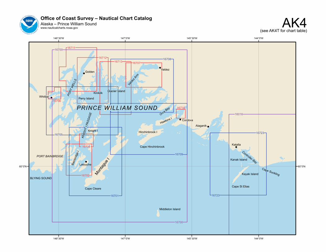
AK4Office of Coast Survey – Nautical Chart CatalogAlaska – Prince William Soundwww.nauticalcharts.noaa.gov
(see AK4T for chart table)
!
!
!
!
!
!
!
144°0'W
144°0'W
145°30'W
145°30'W
147°0'W
147°0'W
148°30'W
148°30'W
60°0'N 60°0'N
16710
16702
16704
16706
16711
1671216713 16707
16723
16723
16701
16709
16705
16708
16700
16700
16016
Montag
ue I
Cape Cleare
Katalla
Kanak Island
Controller Bay
Kayak Island
Cape St Elias
Cape Suckling
Alaganik
Cordova
Orca Bay
Hawkins I
Hinchinbrook I
Cape Hinchinbrook
Middleton Island
PRINCE WILLIAM SOUND
Glacier Island
Valdez
Valdez
Arm
Kinikilk
GoldenPO
RT W
ELLS
Whittier Perry Island
KNIG
HT
I PAS
SAG
E
Knight I
PORT BAINBRDIGE
LatoucheBain
brid
ge I
BLYING SOUND
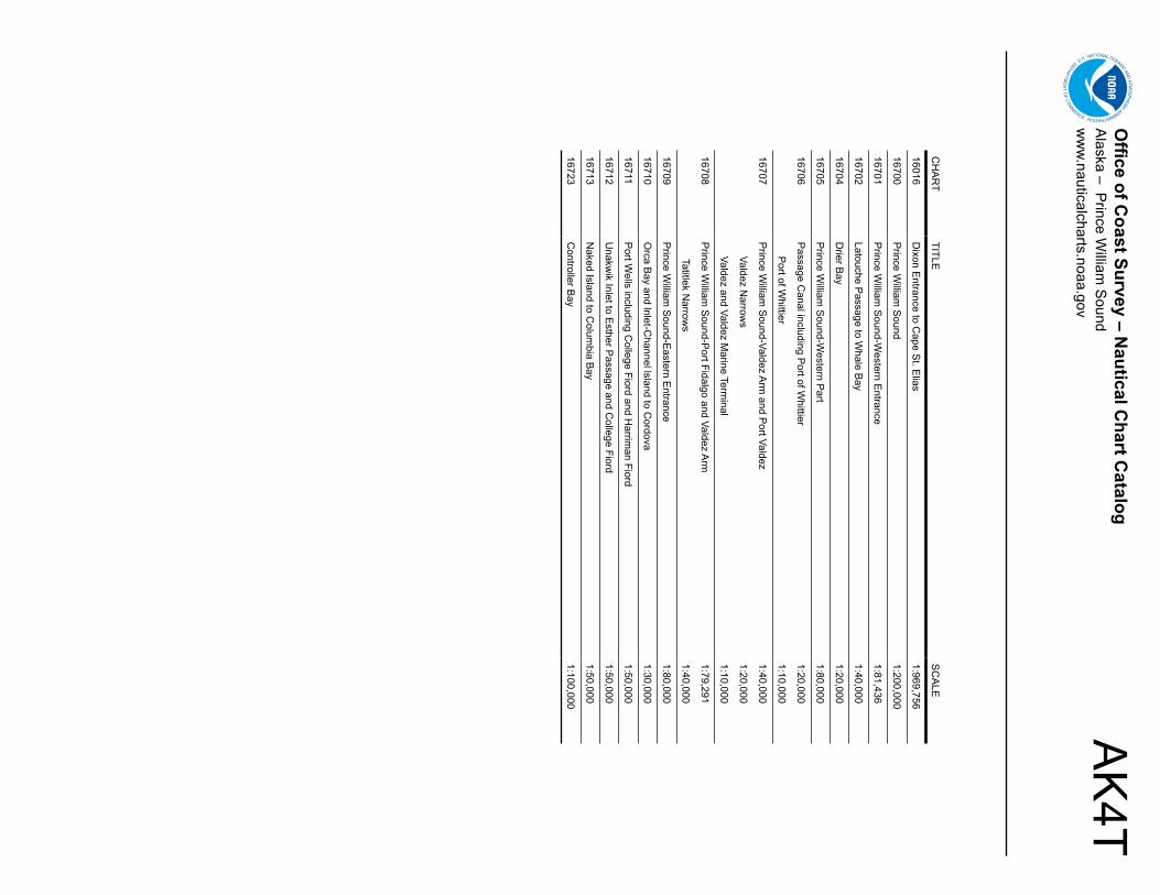
AK
4TO
ffice of Coast Survey – N
autical Chart C
atalogA
laska – Prince W
illiam S
oundw
ww
.nauticalcharts.noaa.gov
CH
AR
TTITLE
SC
ALE
16016D
ixon Entrance to C
ape St. E
lias1:969,756
16700P
rince William
Sound
1:200,000
16701P
rince William
Sound-W
estern Entrance
1:81,436
16702Latouche P
assage to Whale B
ay1:40,000
16704D
rier Bay
1:20,000
16705P
rince William
Sound-W
estern Part
1:80,000
16706P
assage Canal including P
ort of Whittier
1:20,000
Port of W
hittier1:10,000
16707P
rince William
Sound-Valdez A
rm and P
ort Valdez1:40,000
Valdez Narrow
s1:20,000
Valdez and Valdez Marine Term
inal1:10,000
16708P
rince William
Sound-P
ort Fidalgo and Valdez Arm
1:79,291
Tatitlek Narrow
s1:40,000
16709P
rince William
Sound-E
astern Entrance
1:80,000
16710O
rca Bay and lnlet-C
hannel lsland to Cordova
1:30,000
16711P
ort Wells including C
ollege Fiord and Harrim
an Fiord1:50,000
16712U
nakwik Inlet to E
sther Passage and C
ollege Fiord1:50,000
16713N
aked Island to Colum
bia Bay
1:50,000
16723C
ontroller Bay
1:100,000
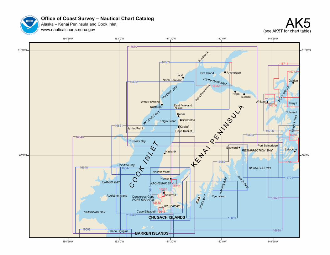
AK5Office of Coast Survey – Nautical Chart CatalogAlaska – Kenai Peninsula and Cook Inletwww.nauticalcharts.noaa.gov (see AK5T for chart table)
148°30'W
148°30'W
150°0'W
150°0'W
151°30'W
151°30'W
153°0'W
153°0'W
154°30'W
154°30'W
61°30'N 61°30'N
60°0'N 60°0'N
!
!
!
!
!
!
!!
!
!
!
!
!
!
!
16608
16606
1664
5
16681
16682
1664716648
16661
16683
16701
16705
16663
16662
16704
16702
16711
16712
16706
16665
1664616648
16646
16646
16660
16640
16680
16670
BARREN ISLANDS
CHUGACH ISLANDSCape Elizabeth
Port Chatham
PORT GRAHAMDangerous Cape Seldovia
KACHEMAK BAYHomer
Anchor Point
Ninilchik
Cape KasilofKasilof
Soldontna
Kenai
NikiskiEast Foreland
Point P
oses
sion
HopeSunrise
Anchorage
TURNAGAIN ARM
Susitin
a R
Fire IslandLadd
North Foreland
TRADING BAY
West Foreland
Kustatan
REDOUBT BAY
Kalgin Island
Harriot Point
Tuxedini Bay
Chinitina Bay
Cape Douglas
ILIAMNA BAY
KAMISHAK BAY
Augistine Island
CO
OK
IN
L ET
KE
NA
I P
EN
I NS
UL A
Nuk
a I
NU
KA B
AY Pye Island
HAR
RIS
BAY
AIALIK BAY
SeawardRESURRECTION BAY
BLYING SOUND
Whittier PORT
WEL
LS
Golden
Perry I
Culross I
LatouchePort Bainbridge
Knig
ht I
Pass
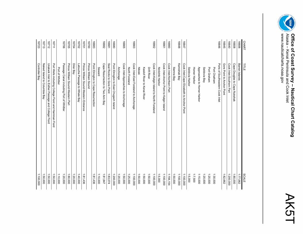
AK
5TO
ffice of Coast Survey – N
autical Chart C
atalogA
laska – Kenai P
eninsula and Cook Inlet
ww
w.nauticalcharts.noaa.gov
CH
AR
TTITLE
SC
ALE
16606B
arren Islands1:77,062
16608C
ape Douglas to C
ape Nukshak
1:80,000
16640C
ook Inlet-Southern P
art1:200,000
16645G
ore Point to A
nchor Point
1:82,662
16646P
orts of Southeastern C
ook Inlet
Port C
hatham1:30,000
Port G
raham1:20,000
Seldovia B
ay1:20,000
Approaches to H
omer H
arbor1:15,000
Hom
er Harbor
1:7,500
Seldovia H
arbor1:5,000
16647C
ook Inlet-Cape E
lizabeth to Anchor P
oint1:100,000
16648K
amishak B
ay1:100,000
lliamna B
ay1:50,000
16660C
ook Inlet-Northern P
art1:194,154
16661C
ook Inlet-Anchor P
oint to Kalgin Island
1:100,000
Ninilchik H
arbor1:5,000
16662C
ook Inlet-Kalgin Island to N
orth Foreland1:100,000
Drift R
iver1:50,000
Kasilof R
iver to Kenai R
iver1:50,000
Nikiski
1:50,000
16663C
ook Inlet-East Foreland to A
nchorage1:100,000
North Foreland
1:25,000
16665C
ook Inlet-Approaches to A
nchorage1:50,000
Anchorage
1:20,000
16680P
oint Elrington to E
ast Chugach Island
1:200,000
16681S
eal Rocks to G
ore Point
1:83,074
16682C
ape Resurrection to Tw
o Arm
Bay
1:81,847
Sew
ard1:10,000
16683P
oint Elrington to C
ape Resurrection
1:81,436
16700P
rince William
Sound
16701P
rince William
Sound-W
estern Entrance
1:81,436
16702Latouche P
assage to Whale B
ay1:40,000
16704D
rier Bay
1:20,000
16705P
rince William
Sound-W
estern Part
1:80,000
16706P
assage Canal including P
ort of Whittier
1:20,000
Port of W
hittier1:10,000
16711P
ort Wells including C
ollege Fiord and Harrim
an Fiord1:50,000
16712U
nakwik Inlet to E
sther Passage and C
ollege Fiord1:50,000
16713N
aked Island to Colum
bia Bay
1:50,000
16723C
ontroller Bay
1:100,000
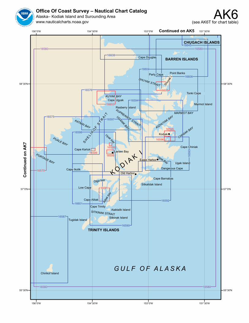
AK6Office Of Coast Survey – Nautical Chart CatalogAlaska– Kodiak Island and Surounding Areawww.nauticalcharts.noaa.gov (see AK6T for chart table)
!
!
!
!
151°30'W
151°30'W
153°0'W
153°0'W
154°30'W
154°30'W
156°0'W
156°0'W
58°30'N 58°30'N
57°0'N 57°0'N
55°30'N 55°30'N
16591
16570
16599
16599
16599
16596
16595
16603
16605
16594
16587
1660116592
16590
16575
16598
16597
1659
3
16576
16604
16608
16606
1664516580 16580
16580 16580
PORTAGE BAY
PUALE BAY
KATMAI BAY
Cape Karluk
Cape Ikolik
Chirikof Island
TRINITY ISLANDS
K O D I AK I
Tugidak IslandSitkinak Island
Aiaktalik IslandSITKINAK STRAIT
Cape Trinity
Alita
k bay
Cape Alitak
Low Cape
Olga bay
Larsen Bay
Uyak bay
Sitkalidak Island
Cape Barnabas
Old Harbor
Dangerous Cape
Eagle HarborUgak Bay Ugak Island
Cape Chiniak
CHINIAK BAY
Kodiak
KIZHUYAK BAYMARMOT BAY
Marmot Island
Tonki Cape
Point Banks
BARREN ISLANDS
CHUGACH ISLANDS
Cape Douglas
Party CapeSHUYAK STRAIT Sh
uyak
I
KUYAK BAYCape Ugyak
Rasberry IslandKUPREANOF STRAIT
UGANIK BAY
SH
EL I K
OF S
T RA
I T
G U L F O F A L A S K A
Con
tinue
d on
AK
7Continued on AK5
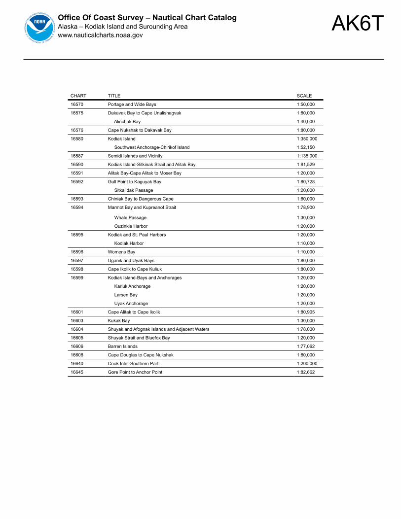
AK6TOffice Of Coast Survey – Nautical Chart CatalogAlaska – Kodiak Island and Surounding Areawww.nauticalcharts.noaa.gov
CHART TITLE SCALE
16570 Portage and Wide Bays 1:50,000
16575 Dakavak Bay to Cape Unalishagvak 1:80,000
Alinchak Bay 1:40,000
16576 Cape Nukshak to Dakavak Bay 1:80,000
16580 Kodiak Island 1:350,000
Southwest Anchorage-Chirikof Island 1:52,150
16587 Semidi Islands and Vicinity 1:135,000
16590 Kodiak Island-Sitkinak Strait and Alitak Bay 1:81,529
16591 Alitak Bay-Cape Alitak to Moser Bay 1:20,000
16592 Gull Point to Kaguyak Bay 1:80,728
Sitkalidak Passage 1:20,000
16593 Chiniak Bay to Dangerous Cape 1:80,000
16594 Marmot Bay and Kupreanof Strait 1:78,900
Whale Passage 1:30,000
Ouzinkie Harbor 1:20,000
16595 Kodiak and St. Paul Harbors 1:20,000
Kodiak Harbor 1:10,000
16596 Womens Bay 1:10,000
16597 Uganik and Uyak Bays 1:80,000
16598 Cape Ikolik to Cape Kuliuk 1:80,000
16599 Kodiak Island-Bays and Anchorages 1:20,000
Karluk Anchorage 1:20,000
Larsen Bay 1:20,000
Uyak Anchorage 1:20,000
16601 Cape Alitak to Cape lkolik 1:80,905
16603 Kukak Bay 1:30,000
16604 Shuyak and Afognak Islands and Adjacent Waters 1:78,000
16605 Shuyak Strait and Bluefox Bay 1:20,000
16606 Barren Islands 1:77,062
16608 Cape Douglas to Cape Nukshak 1:80,000
16640 Cook Inlet-Southern Part 1:200,000
16645 Gore Point to Anchor Point 1:82,662
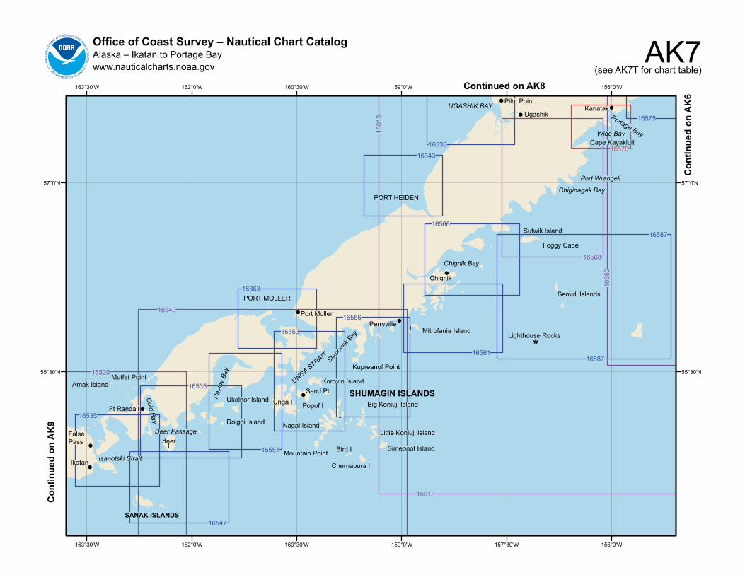
AK7Office of Coast Survey – Nautical Chart CatalogAlaska – Ikatan to Portage Baywww.nauticalcharts.noaa.gov (see AK7T for chart table)
156°0'W
156°0'W
157°30'W
157°30'W
159°0'W
159°0'W
160°30'W
160°30'W
162°0'W
162°0'W
163°30'W
163°30'W
57°0'N 57°0'N
55°30'N 55°30'N
!
!
!
!
!
!
!
!
!
!
16535
16547
16535
16551
16363
16553
16556
1656116587
1658716566
16343
16338
16575
16570
16568
1658
0
16013
1601
3
16540
16520
KanatakPortage Bay
False Pass
Ikatan Isanotski Strait
SANAK ISLANDS
deerI
Deer Passage
Amak IslandMuffet Point
Ft Randall
Cold Bay Dolgoi Island
Ukolnor IslandPavl
ov B
ay
Unga I
PORT MOLLER
Port Moller
Nagai Island
Mountain Point Bird I
Chernabura I
Simeonof Island
Little Koniuji Island
Big Koniuji IslandSHUMAGIN ISLANDS
Popof I
Sand PtUNGA STRAIT
Korovin Island
Stepov
ak B
ay
Kupreanof Point
PerryvilleMitrofania Island
*Lighthouse Rocks
Semidi Islands
Chignik
Chignik Bay
Sutwik Island
Foggy Cape
Wide BayCape Kayakluit
PORT HEIDENChiginagak Bay
Port Wrangell
Pilot Point
UgashikUGASHIK BAY
Con
tinue
d on
AK
9
Con
tinue
d on
AK
6
Continued on AK8
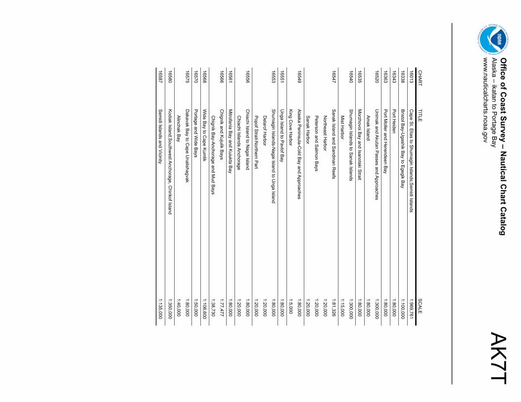
AK
7TO
ffice of Coast Survey – N
autical Chart C
atalogA
laska – ikatan to Portage B
ayw
ww
.nauticalcharts.noaa.gov
CH
AR
TTITLE
SC
ALE
16013C
ape St. E
lias to Shum
agin Islands;Sem
idi Islands1:969,761
16338B
ristol Bay-U
gashik Bay to E
gegik Bay
1:100,000
16343P
ort Heiden
1:80,000
16363P
ort Moller and H
erendeen Bay
1:80,000
16520U
nimak and A
kutan Passes and A
pproaches1:300,000
Am
ak Island 1:80,000
16535M
orzhovoi Bay and Isanotski S
trait1:80,000
16540S
humagin Islands to S
anak Islands1:300,000
Mist H
arbor1:15,000
16547S
anak Island and Sandm
an Reefs
1:81,326
Northeast H
arbor1:20,000
Peterson and S
almon B
ays1:20,000
Sanak H
arbor1:20,000
16549A
laska Peninsula-C
old Bay and A
pproaches1:80,000
King C
ove Harbor
1:5,000
16551U
nga Island to Pavlof B
ay1:80,000
16553S
humagin Islands-N
agai lsland to Unga lsland
1:80,000
Delarof H
arbor1:20,000
Popof S
trait-Northern P
art1:20,000
16556C
hiachi Island to Nagai Island
1:80,000
Chiachi Islands A
nchorage1:20,000
16561M
itrofania Bay and K
uiukta Bay
1:80,000
16566C
hignik and Kujulik B
ays1:77,477
Chignik B
ay-Anchorage and M
ud Bays
1:38,730
16568W
ide Bay to C
ape Kum
lik1:106,600
16570P
ortage and Wide B
ays1:50,000
16575D
akavak Bay to C
ape Unalishagvak
1:80,000
Alinchak B
ay1:40,000
16580K
odiak Island;Southw
est Anchorage, C
hirikof Island1:350,000
16587S
emidi Islands and Vicinity
1:135,000
AK8Office Of Coast Survey – Nautical Chart Catalogregion – Bristol Baywww.nauticalcharts.noaa.gov (see AK8T for chart table)
!
!
!
!!
!
157°30'0"W
157°30'0"W
159°0'0"W
159°0'0"W
160°30'0"W
160°30'0"W
162°0'0"W
162°0'0"W
60°0'0"N 60°0'0"N
58°30'0"N 58°30'0"N
57°0'0"N 57°0'0"N
16304
16305
16315
16322 16323
16338
1633816343
16300
16300
16322
Port Heiden
Pilot Point
Ugashik
Egegik
Ugashik Bay
Cape Greig
Egegik Bay
Cape Chicagof
Naknek
Kvichak B
ay
Etolin Point
Clarks PointNushagak Bay
Cape Constantine
Toglak
Walrus IslandsHagemeister IslandHagemeiste
r Stra
it
Cape Peirce
Cape Newenham
GoodnewsBay
JacksmithBay
Kuskokwim Bay
Kusk
okwi
m R
iver
BRISTOL BAY
Continued on AK7
AK8TOffice Of Coast Survey – Nautical Chart Catalogregion – Bristol Baywww.nauticalcharts.noaa.gov
CHART TITLE SCALE
16300 Kuskokwim Bay 1:200,000
Goodnews Bay 1:80,000
16304 Kuskokwim River-Kuskokwim Bay to Bethel 1:100,000
16305 Bristol Bay-Cape Newenham and Hagemeister Strait 1:100,000
16315 Bristol Bay-Togiak Bay and Walrus Islands 1:100,000
16322 Bristol Bay-Nushagak Bay and Approaches 1:100,000
Dillingham- Small Boat Basin 1:10,000
16323 Bristol Bay-Kvichak Bay and Approaches 1:100,000
16338 Bristol Bay-Ugashik Bay to Egegik Bay 1:100,000
16343 Port Heiden 1:80,000
AK9Office of Coast Survey – Nautical Chart CatalogAlaska – Amukta Island to Unimakwww.nauticalcharts.noaa.gov (see AK9T for chart table)
165°0'W
165°0'W
166°30'W
166°30'W
168°0'W
168°0'W
169°30'W
169°30'W
171°0'W
171°0'W
54°0'N 54°0'N
52°30'N 52°30'N
!
!
!
!
!
16480
16500
16500
16520
16501
16531
16532
16511
1651316514
16515
16516
16521
16517 16522
16518 16528
16530
165
16511
Chagulak I
Amukta I
Con
tinue
d on
AK
11
Con
tinue
d on
AK
7
Yunaska Island
Herbert Island
Carlisle Island
Chuginadak Island
Kagamil IslandISLANDS OF FOUR MOUNTAINS
Samalga Island
Nikolski Bay
BERING SEA
Nikolski Vsevidof Island
Umnak I
Inanudak BayUmnak P
assFort Glenn
Cape Idak
Bogoslof Island
Kuliliak B
ayUsof Bay
Makushin Bay Sedanka Island
Unalaska IKRENITZIN ISLAND
Beaver Inlet
29
Dutch HbrUn
alaska
Bay
kutanA
Akutan I
Akun Island
Tigalda Island
Ugamak Strait
Unimak Passage
Unimak
Cape Sarichef
AK
9TO
ffice of Coast Survey – N
autical Chart C
atalogA
laska – Am
ukta Island to Unim
akw
ww
.nauticalcharts.noaa.gov
CH
AR
TTITLE
SC
ALE
16480A
mukta Island to Igitkin Island
1:300,000
Seguam
Island-Finch Cove
1:20,000
Am
lia Island-Sviechnikof H
arbor1:20,000
16500U
nalaska lsland to Am
ukta lsland1:300,000
16501Islands of Four M
ountains1:80,000
16511Inanudak and N
ikolski Bays
1:40,000
River and M
ueller Coves
1:10,000
16513U
mnak P
ass and Approaches
1:40,000
16514U
nalaska Island-Kuliliak B
ay and Surveyor B
ay1:40,000
16515U
nalaska Island-Chernofski H
arbor to Skan B
ay1:40,000
16516C
hernofski Harbor
1:10,000
16517M
akushin Bay
1:40,000
16518C
ape Kovrizhka to C
ape Cheerful
1:40,000
16520U
nimak and A
kutan Passes and A
pproaches1:300,000
Am
ak Island 1:80,000
16521U
nalaska Island-Protection B
ay to Eagle B
ay1:40,000
16522B
eaver Inlet1:40,000
16528U
nalaska Bay and A
kutan Pass
1:40,000
16529D
utch Harbor
1:10,000
16530C
aptains Bay
1:10,000
16531K
renitzin Islands1:80,000
16532A
kutan Bay
1:20,000
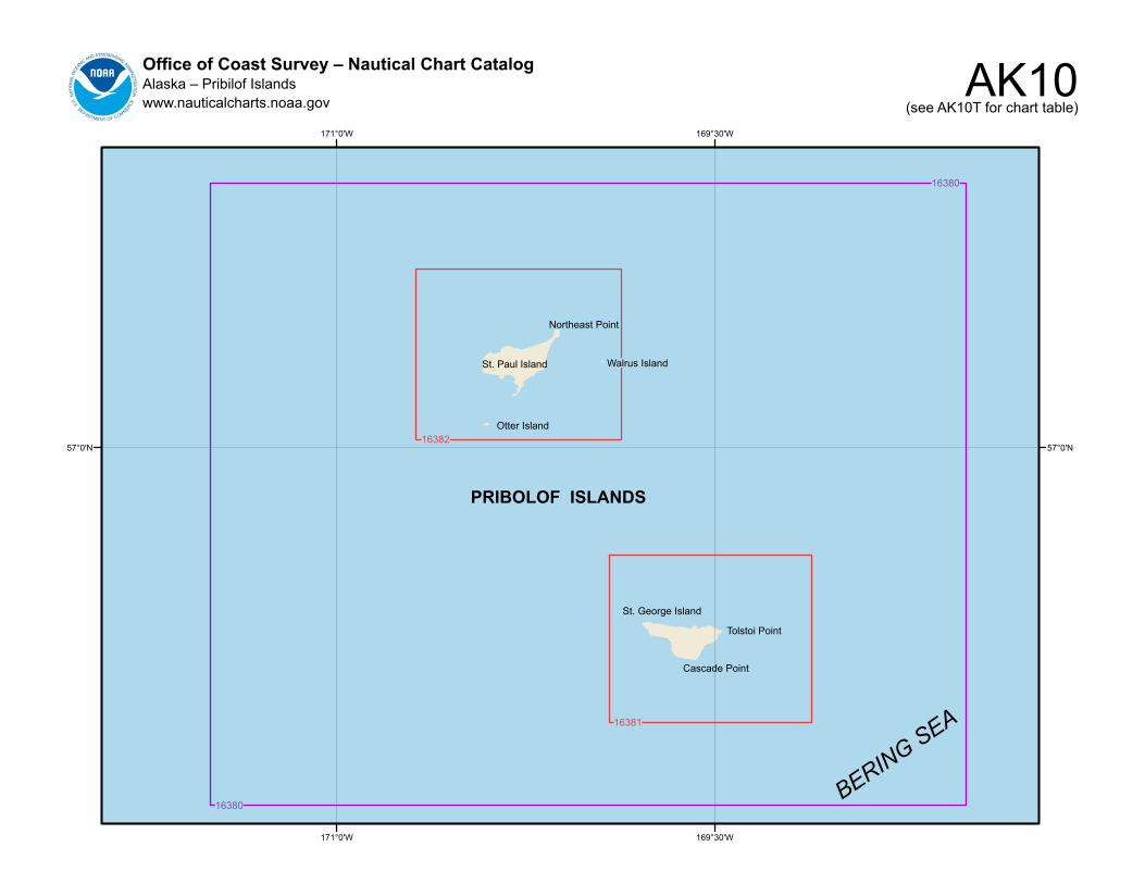
AK10Office of Coast Survey – Nautical Chart CatalogAlaska – Pribilof Islandswww.nauticalcharts.noaa.gov (see AK10T for chart table)
169°30'W
169°30'W
171°0'W
171°0'W
57°0'N 57°0'N16382
16381
16380
16380
PRIBOLOF ISLANDS
BERING SEA
St. George Island
Tolstoi Point
Otter Island
St. Paul Island
Northeast Point
Walrus Island
Cascade Point
AK
10TO
ffice of Coast Survey – N
autical Chart C
atalogA
laska – Pribilof Islands
ww
w.nauticalcharts.noaa.gov
CH
AR
TTITLE
SC
ALE
16380P
ribilof Islands1:200,000
16381S
t. George Island
1:50,000
St. G
eorge Harbor
1:5,000
16382S
t. Paul Island
1:50,000
Village Cove
1:5,000
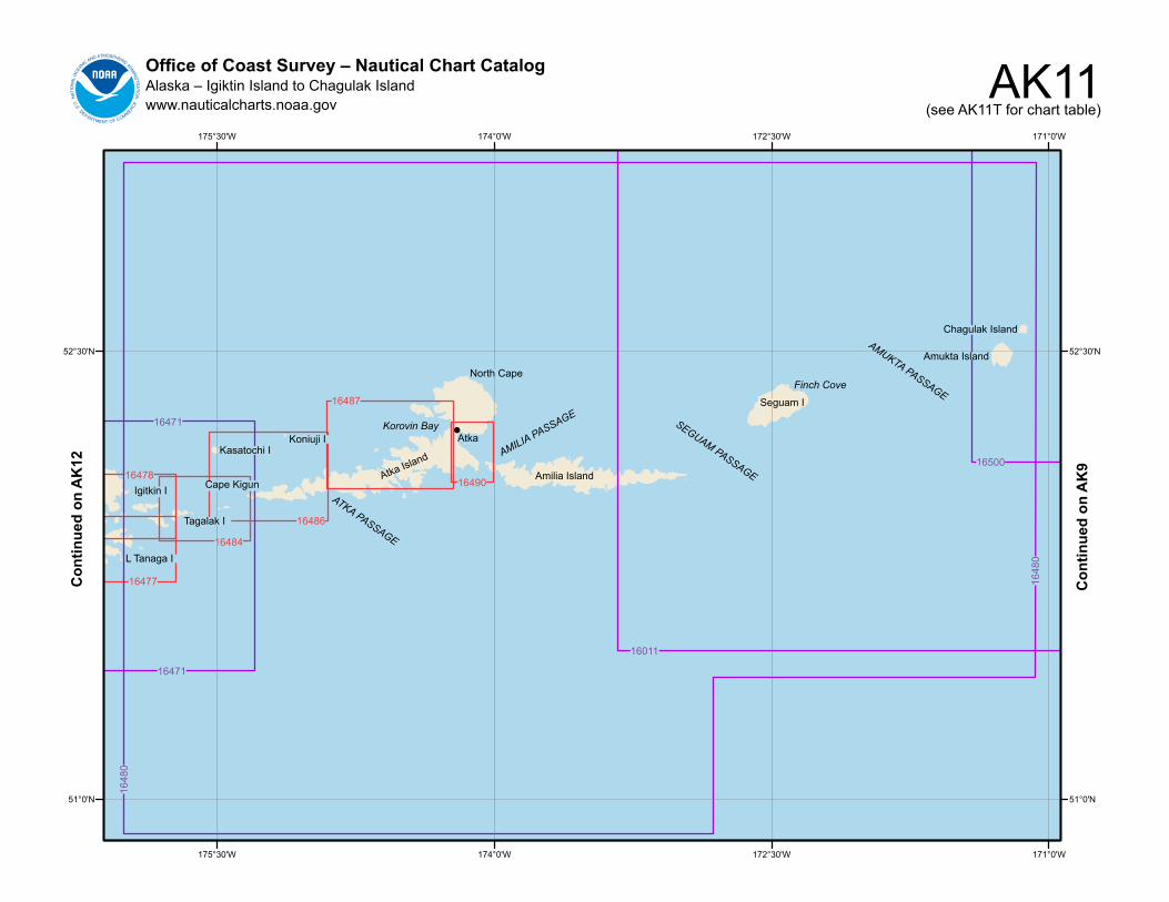
AK11Office of Coast Survey – Nautical Chart CatalogAlaska – Igiktin Island to Chagulak Islandwww.nauticalcharts.noaa.gov (see AK11T for chart table)
171°0'W
171°0'W
172°30'W
172°30'W
174°0'W
174°0'W
175°30'W
175°30'W
52°30'N 52°30'N
51°0'N 51°0'N
!
16490
16487
16486
16484
16478
16477
1648
0
1648
0
16011
16500
16471
16471
Igitkin I
Tagalak I
Cape Kigun
L Tanaga I
Kasatochi IKoniuji I
Atka Island
Korovin Bay
ATKA PASSAGE
Atka
North Cape
AMILIA PASSAGE
Amilia Island
SEGUAM PASSAGE
Seguam I
Finch Cove
AMUKTA PASSAGE
Amukta Island
Chagulak Island
Con
tinue
d on
AK
12
Con
tinue
d on
AK
9
AK
11TO
ffice of Coast Survey – N
autical Chart C
atalogA
laska – Igiktin Island to Chagulak Island
ww
w.nauticalcharts.noaa.gov
CH
AR
TTITLE
SC
ALE
16011A
laska Peninsula and A
leutian Islands to Seguam
Pass
1:1,023,188
16471A
tka Pass to A
dak Strait
1:120,000
Three Arm
Bay
1:120,000
Kanaga B
ay1:40,000
Chapel R
oads and Chapel C
ove1:20,000
16477Tagalak Island to Little Tanaga lsland
1:30,000
16478Tagalak Island to G
reat Sitkin Island
1:30,000
Sand B
ay-Northeast C
ove1:10,000
16480A
mukta Island to Igitkin Island
1:300,000
Seguam
Island-Finch Cove
1:20,000
Am
lia Island-Sviechnikof H
arbor1:20,000
16484A
tka Island to Chugul Island
1:30,000
16486A
tka Island-Western P
art1:40,000
16487K
orovin Bay to W
all Bay
1:40,000
Martin H
arbor1:10,000
16490N
azan Bay and A
mlia P
ass1:20,000
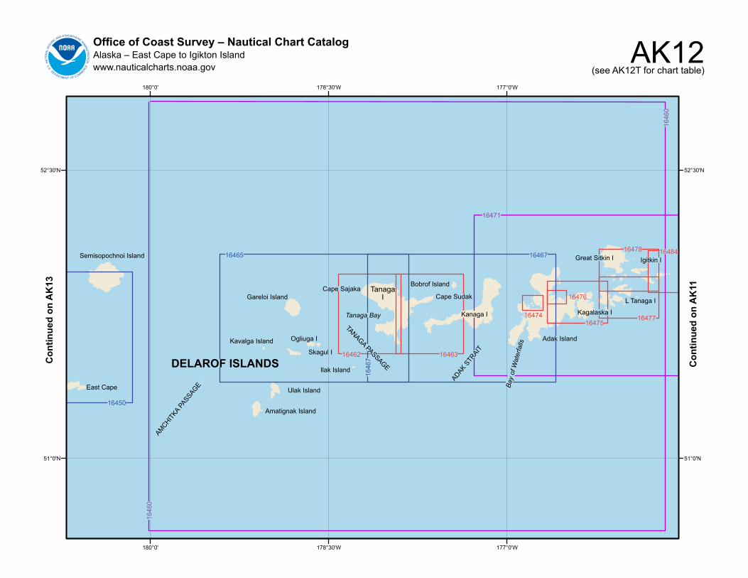
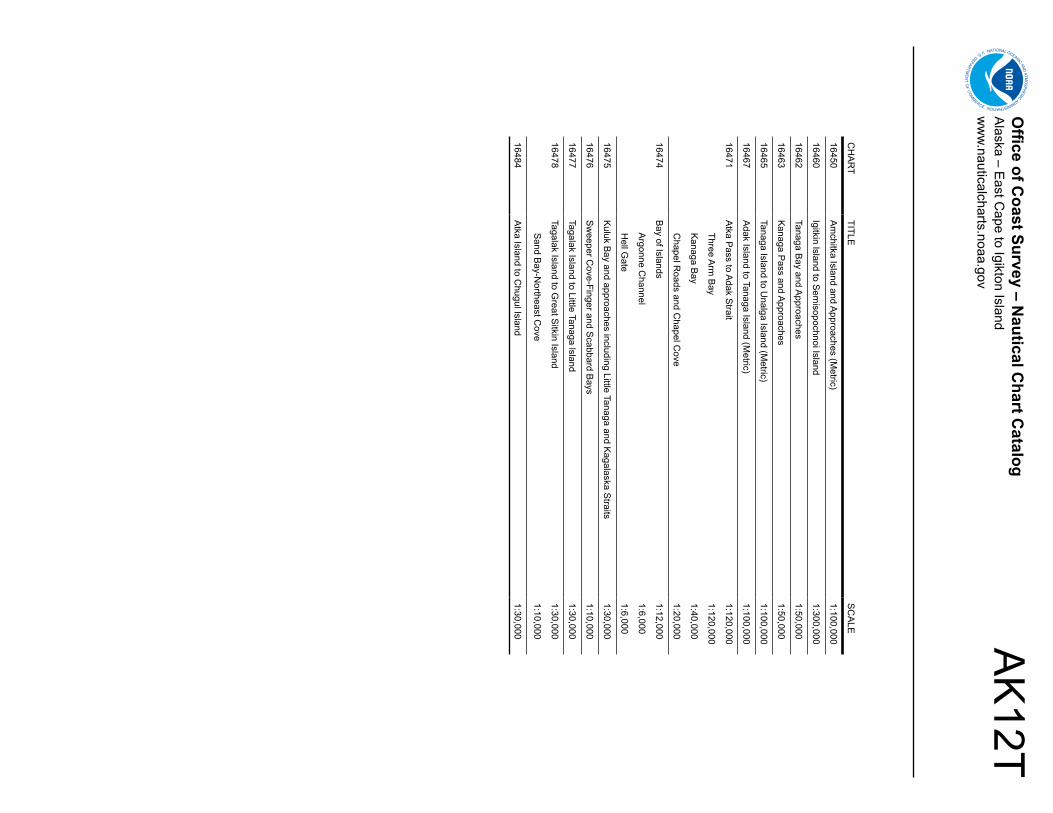
AK12Office of Coast Survey – Nautical Chart CatalogAlaska – East Cape to Igikton Islandwww.nauticalcharts.noaa.gov (see AK12T for chart table)
177°0'W
177°0'W
178°30'W
178°30'W
180°0'
180°0'
52°30'N 52°30'N
51°0'N 51°0'N
1646
0
1646
0
16465
1646
7
16467
16450
16471
16462 16463
16474
16476
1647516477
16478 16484Semisopochnoi Island
East Cape
AMCHITKA
PASSAGE
DELAROF ISLANDS
Ulak Island
Amatignak Island
Ilak Island
Skagul I
Ogliuga IKavalga Island
Gareloi Island
TANAGA PASSAGE
Tanaga Bay
Cape Sajaka TanagaI
Bobrof Island
Cape Sudak
ADAK STR
AIT
Kanaga I
Bay
of W
ater
falls
Adak Island
Kagalaska I
Great Sitkin I
L Tanaga I
Igitkin I
Con
tinue
d on
AK
13
Con
tinue
d on
AK
11
AK
12TO
ffice of Coast Survey – N
autical Chart C
atalogA
laska – East C
ape to Igikton Islandw
ww
.nauticalcharts.noaa.gov
CH
AR
TTITLE
SC
ALE
16450A
mchitka Island and A
pproaches (Metric)
1:100,000
16460Igitkin lsland to S
emisopochnoi Island
1:300,000
16462Tanaga B
ay and Approaches
1:50,000
16463K
anaga Pass and A
pproaches1:50,000
16465Tanaga Island to U
nalga Island (Metric)
1:100,000
16467A
dak Island to Tanaga Island (Metric)
1:100,000
16471A
tka Pass to A
dak Strait
1:120,000
Three Arm
Bay
1:120,000
Kanaga B
ay1:40,000
Chapel R
oads and Chapel C
ove1:20,000
16474B
ay of Islands1:12,000
Argonne C
hannel1:6,000
Hell G
ate1:6,000
16475K
uluk Bay and approaches including Little Tanaga and K
agalaska Straits
1:30,000
16476S
weeper C
ove-Finger and Scabbard B
ays1:10,000
16477Tagalak Island to Little Tanaga lsland
1:30,000
16478Tagalak Island to G
reat Sitkin Island
1:30,000
Sand B
ay-Northeast C
ove1:10,000
16484A
tka Island to Chugul Island
1:30,000
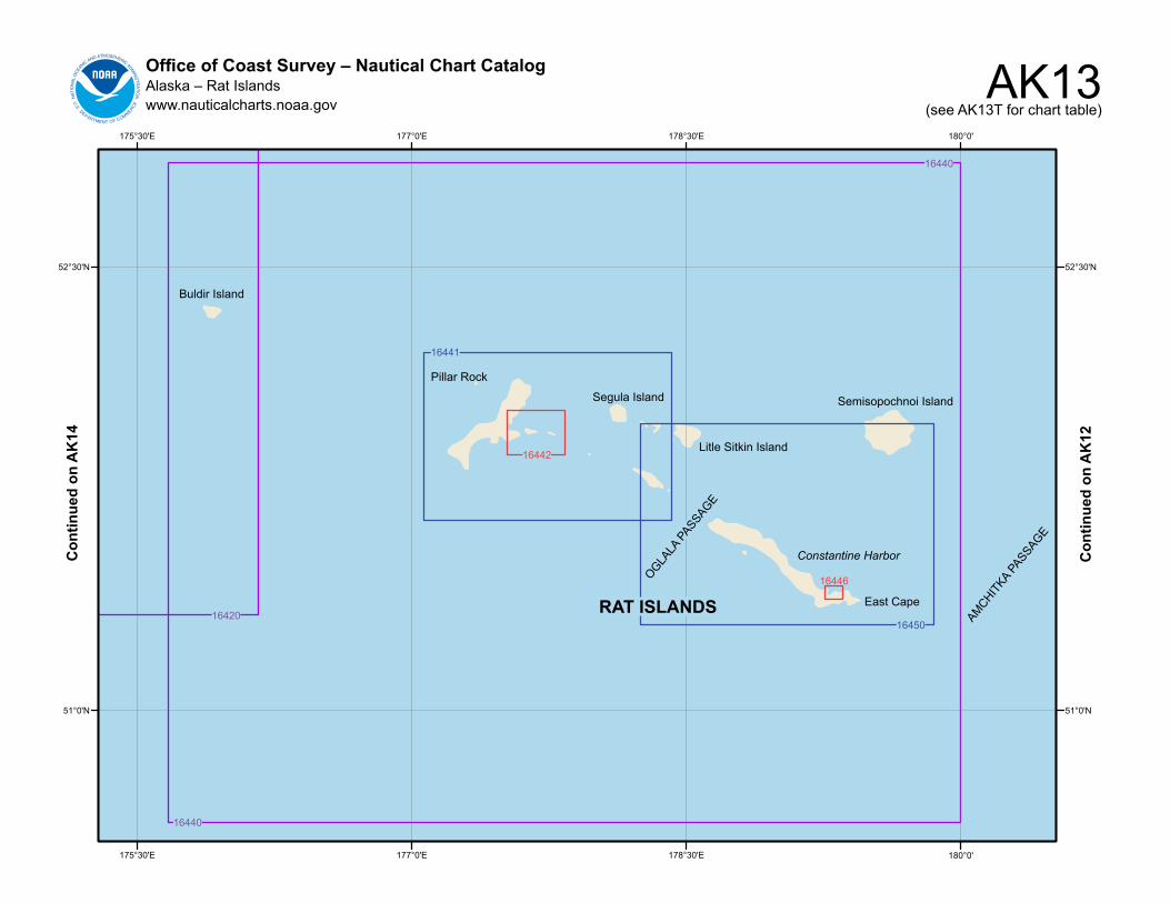
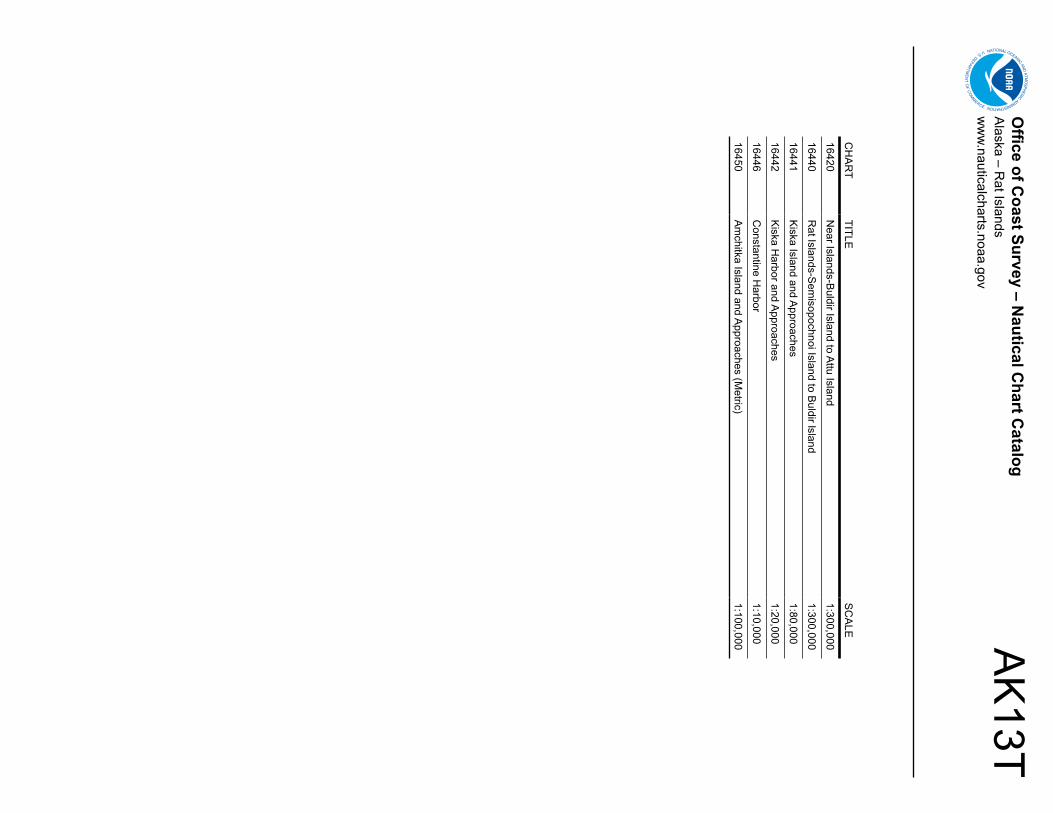
AK13Office of Coast Survey – Nautical Chart CatalogAlaska – Rat Islandswww.nauticalcharts.noaa.gov (see AK13T for chart table)
180°0'
180°0'
178°30'E
178°30'E
177°0'E
177°0'E
175°30'E
175°30'E
52°30'N 52°30'N
51°0'N 51°0'N
16442
16446
16440
16440
1642016450
16441
RAT ISLANDS
Constantine Harbor
East Cape
Semisopochnoi Island
Litle Sitkin Island
OGLALA
PASSAGE
Buldir Island
Pillar Rock
Segula Island
AMCHITKA
PASSAGE
Con
tinue
d on
AK
14
Con
tinue
d on
AK
12
AK
13TO
ffice of Coast Survey – N
autical Chart C
atalogA
laska – Rat Islands
ww
w.nauticalcharts.noaa.gov
CH
AR
TTITLE
SC
ALE
16420N
ear Islands-Buldir Island to A
ttu Island1:300,000
16440R
at Islands-Sem
isopochnoi Island to Buldir lsland
1:300,000
16441K
iska Island and Approaches
1:80,000
16442K
iska Harbor and A
pproaches1:20,000
16446C
onstantine Harbor
1:10,000
16450A
mchitka Island and A
pproaches (Metric)
1:100,000
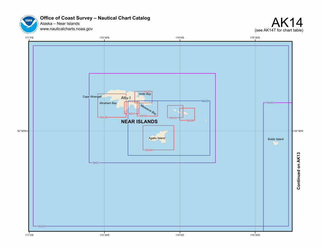
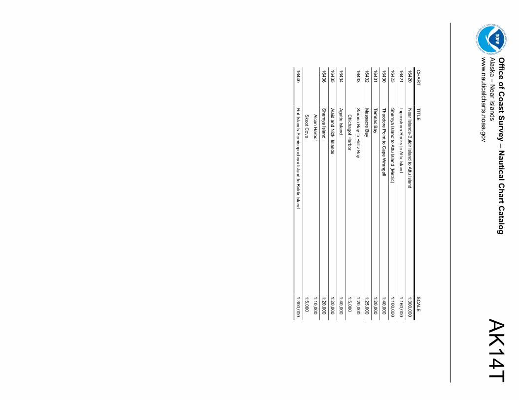
AK14Office of Coast Survey – Nautical Chart CatalogAlaska – Near Islandswww.nauticalcharts.noaa.gov (see AK14T for chart table)
175°30'E
175°30'E
174°0'E
174°0'E
172°30'E
172°30'E
171°0'E
171°0'E
52°30'N 52°30'N
16434
1643216435
16436
16433
1643116430
16423
16421
16420
16440
Buldir IslandAgattu Island
Abraham Bay Massacre Bay
Holtz BayCape Wrangell
NEAR ISLANDS
Attu I
Con
tinue
d on
AK
13
AK
14TO
ffice of Coast Survey – N
autical Chart C
atalogA
laska – Near Islands
ww
w.nauticalcharts.noaa.gov
CH
AR
TTITLE
SC
ALE
16420N
ear Islands-Buldir Island to A
ttu Island1:300,000
16421Ingenstrem
Rocks to A
ttu Island1:160,000
16423S
hemya Island to A
ttu Island (Metric)
1:100,000
16430Theodore P
oint to Cape W
rangell1:40,000
16431Tem
nac Bay
1:20,000
16432M
assacre Bay
1:25,000
16433S
arana Bay to H
oltz Bay
1:20,000
Chichagof H
arbor1:5,000
16434A
gattu Island 1:40,000
16435A
laid and Nizki Islands
1:20,000
16436S
hemya Island
1:20,000
Alcan H
arbor1:10,000
Skoot C
ove1:5,000
16440R
at Islands-Sem
isopochnoi Island to Buldir lsland
1:300,000
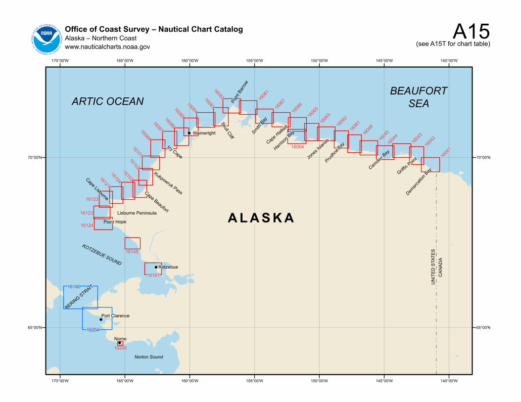
A15Office of Coast Survey – Nautical Chart CatalogAlaska – Northern Coastwww.nauticalcharts.noaa.gov (see A15T for chart table)
!
!
!
!
140°00'W
140°00'W
145°00'W
145°00'W
150°00'W
150°00'W
155°00'W
155°00'W
160°00'W
160°00'W
165°00'W
165°00'W
170°00'W
170°00'W
70°00'N 70°00'N
65°00'N 65°00'N
16161
16206
16124
16123
16122
1612116104
1610316102
1610116088
1608716086
1608516084
1608316082
1608
1
1606
7
1606
6
1606
5
16064
1606
3
1606
216
061
1604
6
1604
516
044
1604
316
042
1604
1
16190
16204
BERING STRAIT
Port Clarence
Norton Sound
A L A S K A
ARTIC OCEAN
Nome
Lisburne Peninsula
Kotzebue
Point Hope
Cape LisburneCape Beaufort
Kukpowruk Pass
Icy Cape
Wainwright
Skull Cliff
Point
Bar
row
th Bay
Cape Halkett
Smi
Harriso
n Bay
Jone
s Isla
nds
Bay
Camde
n Bay
Prudho
e
Griffin Point
Demarc
ation
Bay
CA
NA
DA
UN
ITE
D S
TATE
S
KOTZEBUE SOUND
BEAUFORT SEA
16145
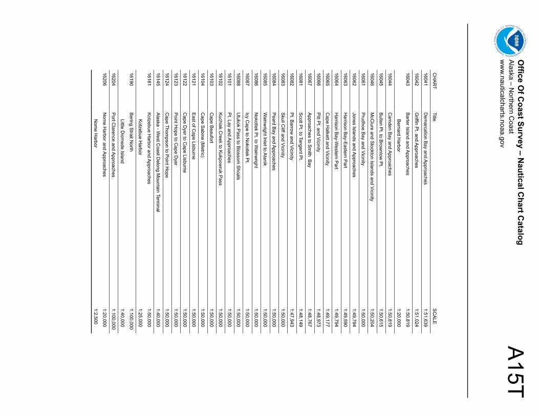
A15T
Office O
f Coast Survey – N
autical Chart C
atalogA
laska – Northern C
oastw
ww
.nauticalcharts.noaa.gov
CH
AR
TTitle
SC
ALE
16041D
emarcation B
ay and Approaches
1:51,639
16042G
riffin Pt. and A
pproaches1:51,024
16043B
arter Island and Approaches
1:50,819
Bernard H
arbor1:20,000
16044C
amden B
ay and Approaches
1:50,819
16045B
ullen Pt. to B
rownlow
Pt.
1:50,615
16046M
cClure and S
tockton Islands and Vicinity1:50,204
16061P
rudhoe Bay and Vicinity
1:50,000
16062Jones Islands and A
pproaches1:49,794
16063H
arrison Bay-E
astern Part
1:49,590
16064H
arrison Bay-W
estern Part
1:49,794
16065C
ape Halkett and Vicinity
1:49,177
16066P
itt Pt. and Vicinity
1:48,973
16067A
pproaches to Sm
ith Bay
1:48,767
16081S
cott Pt. to Tangent P
t.1:48,149
16082P
t. Barrow
and Vicinity1:47,943
16083S
kull Cliff and Vicinity
1:50,000
16084P
eard Bay and A
pproaches1:50,000
16085W
ainwright Inlet to A
tanik1:50,000
16086N
okotlek Pt. to W
ainwright
1:50,000
16087Icy C
ape to Nokotlek P
t.1:50,000
16088U
tukok Pass to B
lossom S
hoals1:50,000
16101P
t. Lay and Approaches
1:50,000
16102K
uchiak Creek to K
ukpowruk P
ass1:50,000
16103C
ape Beaufort
1:50,000
16104C
ape Sabine (M
etric)1:50,000
16121E
ast of Cape Lisburne
1:50,000
16122C
ape Dyer to C
ape Lisburne1:50,000
16123P
oint Hope to C
ape Dyer
1:50,000
16124C
ape Thompson to P
oint Hope
1:50,000
16145A
laska - West C
oast Delong M
ountain Terminal
1:40,000
16161K
otzebue Harbor and A
pproaches 1:50,000
Kotzebue H
arbor1:25,000
16190B
ering Strait N
orth1:100,000
Little Diom
ede Island1:40,000
16204P
ort Clarence and A
pproaches1:100,000
16206N
ome H
arbor and Approaches
1:20,000
Nom
e Harbor
1:2,500
![Sound the Trumpet - American Choral Directors Association · [Allegro Moderato] Purcell Sound 4 the Sound trum- pet, the 7 Sound the trum pet, sound, sound, sound the trum - tillpet](https://img.pdfslide.us/doc/110x75/5afa256f7f8b9ae92b8d54d8/sound-the-trumpet-american-choral-directors-association-allegro-moderato-purcell.jpg)