Embed Size (px)
Citation preview
Alabama’s Artificial ReefsA Fishing Information Guide
CO
NS
ERV
ATION AND NATURAL RESO
UR
CE
S
MA
RINE
RESOURCES DIVIS
ION
Marine Resources DivisionALABAMA DEPARTMENT OF CONSERVATION
AND NATURAL RESOURCES
Marine Resources DivisionALABAMA DEPARTMENT OF CONSERVATION
AND NATURAL RESOURCES
• Offshore and Inshore Reefs• Reef Location Charts• GPS Coordinates• Reef Construction Protocol• Program History
Revised 2009
ALABAMA ARTIFICIAL REEF GENERAL PERMIT AREAS
ALABAMA’SARTIFICIAL REEF PROGRAM
Alabama has one of the largest artificialreef programs in the world. The naturalbottom of offshore Alabama is apredominately flat sand/mud type bottom.This bottom type attracts very few fish thatare either commercially or recreationallyvaluable. However, it has long been knownthat if vertical relief is created on this bottom,many reef fish such as snappers andgroupers will be produced. In fact, artificialreefs can be created that over time willappear as natural reefs with similarcommunities of encrusting organisms andbait fish. As various encrusting organismssuch as corals and sponges cover theartificial reef material, small animals take upresidence. On-going research withinAlabama’s artificial reef general permit areasindicates that juvenile red snapper recruitto new, uninhabited artificial reefs, agingwith the reef, and recruiting to the fishery atan appropriate size. At that point the artificialreef functions as a natural reef.
Alabama's artificial reef building programstarted in 1953 when the Orange BeachCharter Boat Association asked for theauthority to place 250 car bodies off BaldwinCounty, Alabama. This proved to be verysuccessful and in the years since, manydifferent types of materials have been placedoffshore of Alabama. These have includedadditional car bodies, culverts, bridge rubble,barges, boats and planes. In 1974, in anexcellent example of State/Federalcooperation, several "ghost-fleeted" libertyships were sunk in five locations off Mobileand Baldwin Counties in 80-93 feet of water.
In 1987, a general permit was issued bythe U. S. Army Corps of Engineerscreating specific areas offshore ofAlabama for the creation of artificial reefs.These were created in order to provide areasfor these materials in order to coordinatewith other users of the offshore area. In 1987the areas encompassed almost 800 squaremiles.
In 1993, the U. S. military in addressing theneed to de-militarize obsolete battle tanksrealized that immersion in sea water wasan acceptable method. The idea waspresented to the Marine Resources Divisionand development of an operation planbegan. Reef-Ex is the program name
SAFETY FAIRWAY
SAFETYFAIRW
AY
SAFETYFAIRW
AY
Dauphin Is.
Mobile Bay
Farewell Buoy
Gulf Shores
Ft. Morgan
Gu
l fo
fM e x i c o
HUGH SWINGLEGENERAL
PERMIT AREA
• 30°
03.
50’
87
° 32.
30’
• 29° 34.00’ 87° 32.30’
• 29° 24.10’
88° 01.00’
• 29° 25.50’
87° 50.20’
29° 35.50’88° 01.50’ •
29° 55.00’88° 07.00’ •
29° 45.20’• 88° 02.00’
29° 5
5.00
’
88° 0
2.50
’ • • 29° 55.00’
87° 55.50’
30° 03.00’• 87° 59.50’
• 29° 29.20’ 87° 32.30’
30° 03.00’88° 07.00’ •
30° 0
2.20’
• 87° 5
2.70’
• 29° 52.00’ 87° 47.00’
29° 47.20’ •
87° 46.50’
• 29° 55.00’ 87° 47.25 ’
• 29° 16.60’ 87° 32.30’
DON KELLEYSOUTH
GENERALPERMIT AREA
TATUM - WINNNORTH GENERAL
PERMIT AREA
TATUM - WINNSOUTH GENERAL
PERMIT AREA
SAFETYFAIRW
AY
29° 29.00’87° 45.00’ •
SAFETYFAIRW
AY
• 29° 25.50’
87° 50.20’
29° 26.40’87° 44.90’ •
29° 4
3.10’
•
87° 4
6.00’
DON KELLEYNORTH
GENERALPERMIT AREA
0
5
10SCALE - MILES
associated this activity. In 1994, one-hundred M-60 military tanks were deployedas artificial reefs in depths of 70 to 110 feet of water within the Hugh Swingleand Don Kelley North permit areas. The conservative estimate for the life spanof the tanks is 50 years as artificial reefs.
In late 1997, the U. S. Army Corps of Engineers authorized an expansion ofAlabama's artificial reef construction areas to allow for greater freedom in reefplacement and greater variety in depth. The combined area for all reef permitzones now encompasses approximately 1260 square miles. At the same time,the protocol for reef construction was modified. This modification limited thetypes of materials that can be used to construct artificial reefs. Enforcementof the protocol and placement of reefs is a joint effort of the Marine ResourcesEnforcement Section, the Alabama Marine Police Division, and the U. S. CoastGuard.
Perdido Pass
2
W
S
N
E
PUBLIC REEFS - DON KELLEY NORTH GENERAL PERMIT AREA
Wallace Reef(Liberty Ship)
Tank 90A
105’ Tug
Lipscomb TugBuffalo Barge 2
Buffalo Barge 1
Tank 90BTank 90C
Tank 89A
Perdido Bridge 1
Perdido Bridge 2Perdido Bridge 3
Perdido Bridge 4
Perdido Bridge 5
Tank 89B
Tank 89C
Tank 56
Tank 85BTank 85A
Tank 91
Tank 86B
Tank 86A
Tank 55
Tank 74A
Tank 61
Tank 59
Tank 93B
Tank 74B
Tank 62
Tank 60
Tank 38
Tank 93ATank 39
Tank 40
Tank 41
Tank 53
Tank 54
Tank 42Tank 51
Tank 52
Tank 93C
Tank 75Sparkman Reef(Liberty Ship)
Hunt Reef
Tank 77ATank 77B
Tank 76ATank 43
Tank 44
Tank 45
Tank 46Tank 47
Tank 48
Tank 49
Tank 50
Tank 66
Tank 67
Tank 68
Tank 69
Tank 70A
Tank 70B
Tank 71
Tank 72Tank 58
Tank 64
Tank 63
Tank 73
Tank 65
Tank 57
Tank 81CTank 82ATank 82B
Tank 80
Tank 81B
Tank 81A
Tank 78B Tank 79Tank 78A
CSX Boxcars
Tank 87
Tank 88B
Tank 88A
Lillian Bridge
GULF OF MEXICO
Tank 38 30°00.691 87°43.911Tank 39 29°59.715 87°43.791Tank 40 29°58.652 87°43.714Tank 41 29°57.670 87°43.645Tank 42 29°56.674 87°43.534Tank 43 29°55.640 87°43.409Tank 44 29°54.637 87°43.330Tank 45 29°53.673 87°43.244Tank 46 29°52.541 87°43.149Tank 47 29°52.610 87°44.105Tank 48 29°53.565 87°44.245Tank 49 29°54.619 87°44.335Tank 50 29°55.560 87°44.428Tank 51 29°56.612 87°44.510Tank 52 29°57.590 87°44.600Tank 53 29°58.650 87°44.700Tank 54 29°59.650 87°44.800Tank 55 29°59.642 87°45.733Tank 56 29°58.385 87°46.421Tank 57 29°57.835 87°46.600Tank 58 29°56.814 87°46.505Tank 59 29°55.743 87°46.422Tank 60 29°54.715 87°46.333Tank 61 29°53.744 87°46.246Tank 62 29°52.710 87°46.170Tank 63 29°51.775 87°46.083Tank 64 29°49.820 87°44.540Tank 65 29°50.438 87°44.809Tank 66 29°51.375 87°44.984Tank 67 29°52.347 87°45.102Tank 68 29°53.343 87°45.220Tank 69 29°54.350 87°45.330Tank 70 29°55.368 87°45.387Tank 71 29°56.208 87°45.406Tank 73 29°57.376 87°45.576
Tank 74 29°58.718 87°46.595Tank 74 29°58.689 87°46.596Tank 75 * 29°59.736 87°42.790Tank 76 * 29°55.830 87°41.355Tank 77 * 29°55.973 87°39.885Tank 78 29°56.025 87°37.425Tank 78 29°56.030 87°37.390Tank 78 29°56.030 87°37.340Tank 79 29°56.085 87°34.910Tank 80 29°51.995 87°37.027Tank 81 29°51.145 87°36.945Tank 81 29°51.135 87°36.970Tank 81 29°51.125 87°36.937Tank 82 29°51.230 87°34.340Tank 82 29°51.305 87°34.345Tank 83 **Tank 84 **Tank 85 30°00.845 87°40.185Tank 85 30°00.820 87°40.235Tank 86 30°00.965 87°37.830Tank 86 30°00.950 87°37.785Tank 87 30°00.063 87°35.279Tank 88 30°00.998 87°35.260Tank 88 30°00.985 87°35.285Tank 89 30°01.963 87°33.975Tank 89 30°01.977 87°33.950Tank 89 30°01.990 87°33.945Tank 90 30°03.925 87°34.185Tank 90 30°03.890 87°34.190Tank 90 30°03.885 87°34.223Tank 91 29°59.953 87°37.681Tank 92 **Tank 93 29°59.913 87°41.961Tank 93 29°59.950 87°41.980Tank 93 29°59.950 87°41.980
Tank 78CTank 77A
Military Tank Reefs
General Public Reefs
Tank 83
Lillian BridgePerdido Pass Bridge 1Perdido Pass Bridge 2Perdido Pass Bridge 3Perdido Pass Bridge 4Perdido Pass Bridge 5
GULF OF MEXICOGULF OF MEXICO
DON KELLEY SOUTH
GENERALPERMIT AREA
HUGHSWINGLEGENERAL
PERMIT AREA
TATUM - WINNNORTH
GENERALPERMIT AREA
DON KELLEYNORTH
GENERALPERMITAREA
TATUM - WINNSOUTH
GENERAL PERMIT AREA
DON KELLEYNORTH
GENERALPERMITAREA
Area Enlarged
* Multiple tanks at location ** Coordinates not available.
30°06.881 87°32.68530°01.913 87°33.54530°02.309 87°33.24530°02.805 87°33.10030°03.122 87°32.87330°03.630 87°32.716
Sparkman Reef 29°59.676 87°43.050Wallace Reef 30°05.235 87°34.636105’ Tug 30°03.888 87°42.455Lipscomb Tug 30°04.880 87°48.180Buffalo Barge I 30°05.040 87°49.950Buffalo Barge II 30°04.780 87°50.440CSX Reef Boxcxars 29°59.563 87°33.371Hunt Reef 29°56.110 87°41.864
3
GULF OF MEXICOGULF OF MEXICO
DON KELLEY SOUTH
GENERALPERMIT AREA
TATUM - WINNNORTH
GENERALPERMIT AREA
DON KELLEYNORTH
GENERALPERMITAREA
TATUM - WINNSOUTH
GENERAL PERMIT AREA
PUBLIC REEFS - HUGH SWINGLE GENERAL PERMIT AREA
Area Enlarged
Tank 96A
D. I. Bridge
D. I. Bridge
D. I. Bridge
D. I. Bridge
D. I. Bridge
D. I. Bridge
Old Drydock
Tulsa
Tank 95B
D. I. Bridge
Concrete Pipes
Tank 94A
Scott Barge
Tensaw Bridge
Tank 99A
Tank 99B
D. I. Bridge
Papa Joe Memorial
Anderson (Liberty Ship)
Tank 98
McMillan Barge
Tank 96B
Southeast Banks
Tank 102A
Sims Memorial 1
Atlantic Marine DrydockD. R. Dunlap Reef
Tank 101
Frank Broz Mem.1,2 & 3
Tank 100
Tensaw Bridge
Tensaw Bridge
Tensaw Bridge
Tensaw Bridge
Tensaw Bridge Tank 97A
Tank 97B
Tank 94B
Tank 94C
Sims Memorial 2 & 3Tank 102B Tank 102C
Edwards (Liberty Ship)
Southwest Rock
GULF OF MEXICO
Nail Ship
Lawrence Sims Reef * 30°00.238 88°02.156Frank Broz Reef * 30°00.308 88°01.803Tank 94 29°58.303 88°04.586Tank 94 29°58.290 88°04.480Tank 94 29°58.300 88°04.420Tank 95 * 29°59.358 88°06.236Tank 96 30°00.642 88°06.818Tank 96 30°00.643 88°06.816Tank 97 29°58.345 88°05.884Tank 97 29°58.355 88°05.608Tank 98 29°57.339 88°05.985Tank 99 29°59.387 88°06.956Tank 99 29°59.406 88°06.899Tank 100 29°58.325 88°02.460Tank 101 29°58.474 88°00.568Tank 102 * 30°00.518 88°00.147
Military Tank ReefsGeneral Public ReefsFarewell BuoyPapa Joe MemorialAnderson ReefOld Dry-DockEdwards ReefMcMillian BargeScott BargeSoutheast BanksSouthwest RockTulsaDauphin Isl. BridgeDauphin Isl. BridgeDauphin Isl. BridgeNail ShipD.R. Dunlap DrydockTensaw BridgeTensaw BridgeTensaw BridgeTensaw BridgeTensaw BridgeTensaw Bridge
Deployment of Atlantic Marine Drydock(D. R. Dunlap Reef)
M-60 Military Tank Reef
* Multiple tanks at location
HUGHSWINGLEGENERAL
PERMIT AREA
30°07.49029°59.97929°59.04130°01.34729°57.93129°58.76629°59.18030°01.42530°06.41430°01.06830°02.53730°02.78630°01.17029°57.57329°56.58629°56.30029°56.54329°57.75329°57.32929°58.35729°58.277
88°04.13088°07.45988°04.30588°07.16388°06.59788°02.70088°01.74087°56.90088°12.27588°06.46288°05.79688°04.56588°04.84688°09.69288°01.84688°02.43988°02.44088°02.69188°02.32788°06.56688°06.562
4
GULF OF MEXICOGULF OF MEXICO
DON KELLEY SOUTH
GENERALPERMIT AREA
TATUM - WINNNORTH
GENERALPERMIT AREA
DON KELLEYNORTH
GENERALPERMITAREA
TATUM - WINNSOUTH
GENERAL PERMIT AREA
CONCRETE CULVERT PIPE REEFS - 2004
Area Enlarged
Atlantic Marine Pipe 1
Atlantic Marine Pipe 2
Atlantic Marine Pipe 3
Hanson Pipe 1
Hanson Pipe 2
Hanson Pipe 3
Mobile Co. Roadbuilders Assoc. 1
Mobile Co. Roadbuilders Assoc. 2
Mobile Co. Roadbuilders Assoc. 3
Mobile Co. Roadbuilders 1 29°55.087 - 87°57.535Mobile Co. Roadbuilders 2 29°54.087 - 87°57.002Mobile Co. Roadbuilders 3 29°53.045 - 87°57.520
Hanson Pipe 1 29°57.544 - 87°58.626 Hanson Pipe 2 29°56.509 - 87°58.577 Hanson Pipe 3 29°55.512 - 87°58.582
Atlantic Marine Pipes 1 30°02.002 - 87°49.566 Atlantic Marine Pipes 2 30°01.042 - 87°49.564 Atlantic Marine Pipes 3 30°00.004 - 87°49.561
GULF OF MEXICO
DON KELLEYNORTH
GENERALPERMITAREA
TATUM - WINNNORTH
GENERALPERMIT AREA
HUGHSWINGLEGENERAL
PERMIT AREA
HUGHSWINGLEGENERAL
PERMIT AREA
5
6
RSWC* ARTIFICIAL REEF MODULES - 2004 DEPLOYMENT
121
120
122
118
116
114123
119
117
115
113
109
209
103
192
46
127126
98
178
179
180
181
182
183
184
196
197 191
185
212
210
207
208
195
198
199
186
213
211
205
206
193
190
200
202
112
111
203
204
124
189
201
59
102
110
108
52
187
31
132
97
107
106
90
13
99
94
101
93
194
24
96
100
105 91
95
104
92
188
47
30
160
125
80
45
66
81 60
62
49
61
63
65
84
48
79
74
77
75
82
76
85
78
89 67
83
88
86
87
64
17
8
131
136
161
129
55
130
54
51
128
56
53
50
58
57
162
154
28
134
27
38
25
133
26
3734
36
39
33
35
32
40
42
41
43
44
11
152
16
21
22
155
23
157
29
159
158
156
163
153
7
18
135
12
19
20
6
9
15
137
10
14
4
5
3
268
1
144
149
150
148
138
147
146172 143
168169
167
165
166
164
139
151
142
145
174
141
173
171
140
170
176177
175
69
71
70
72
73
214
215
GULF OF MEXICOGULF OF MEXICO
RSWC* (Red Snapper World Championship)Visit: www.redsnapperworldchampionship.com
RSWC 2004 REEF MODULES - GPS COORDINATES30°02.89430°01.84430°00.88929°59.87629°58.85429°57.83129°56.84229°55.83229°54.85529°53.83229°52.77429°51.78329°50.72829°49.73229°49.95329°50.84929°52.41029°48.50929°46.51429°44.36829°42.39029°40.38229°38.38129°41.77729°43.75129°45.77429°47.76929°49.31629°48.68529°46.74729°47.41029°41.47229°39.42629°37.35929°35.23029°39.07629°37.02329°35.01329°35.20229°37.27029°39.31829°41.33829°43.38329°45.40729°43.37129°42.35829°41.26429°40.21829°39.29929°38.17429°37.13829°36.02229°35.05729°35.05329°36.04629°37.10529°38.16629°39.17429°40.20629°41.27429°42.30429°43.40829°44.46229.45.50429°38.04429°39.15729°46.51230°02.02030°00.94730°00.12329°59.26129°58.32729°57.47929°48.65529°47.55729°46.55929°45.44529°44.40429°43.27529°42.32929°41.26629°40.17629°40.10929°41.27329°42.47929°43.44029°44.61029°45.64629°46.73229°47.85029°48.79729°48.80629°47.70629°46.67229°45.60029°44.57229°43.55829°42.68229°41.68929°43.47629°44.52529°45.60929°46.65429°47.69629°48.68829°48.63229°47.88629°46.841
87°34.64887°34.69187°34.74487°34.71987°34.80087°34.69087°34.72787°34.69687°34.63687°34.70287°34.67187°34.61387°34.65387°34.68087°36.98987°36.47887°36.46787°34.83187°34.87887°34.00587°35.12687°35.22187°35.42087°37.97487°37.87587°37.80187°37.73287°37.79787°40.69587°40.62187°41.57687°43.29687°43.32387°43.34687°43.33487°40.96787°40.99787°41.49287°45.62087°45.58587°45.61787°45.56287°45.56387°45.68487°46.58287°46.69187°46.70587°46.76187°46.79987°46.98287°46.98287°47.02087°47.14187°49.47287°49.64987°49.49187°49.53887°49.64487°49.61087°49.49687°49.39187°49.30987°49.20987°49.13987°52.45187°52.38787°49.14887°54.87087°50.71187°50.13887°49.51187°48.88787°48.24687°51.81087°51.75387°51.88887°51.90587°52.02087°52.11087°52.13887°52.36287°52.30487°55.32287°55.31987°55.30987°55.25687°55.28087°55.18487°55.21287°55.26787°55.32287°57.64987°57.69287°57.69787°57.78187°57.79187°57.86187°57.91287°57.98987°59.69787°59.73087°59.62787°59.63087°59.63787°59.62788°01.03688°01.02588°01.046
Flora-Bama 1Flora-Bama 2Reynold's Ready Mix USA Pope #1Reynold's Ready Mix USA Butts #2Reynold's Ready Mix USA #3Reynold's Ready Mix USA #4Reynold's Ready Mix USA #5Joe Raley Builders - Big MommaJoe Raley BuildersTop Gun Tackle #1Top Gun Tackle #2Home Port Marina #1Home Port Marina #2Home Port Marina #3Home Port Marina #4Home Port Marina #5Brett Robinson #1Brett Robinson #2Brett Robinson #3Brett Robinson #4Brett Robinson #5Brett Robinson #6Brett Robinson #7Brett Robinson #8Brett Robinson #9Brett Robinson #10Brett Robinson #11Brett Robinson #12Brett Robinson #13Brett Robinson #14Brett Robinson #15Brett Robinson #16Brett Robinson #17Brett Robinson #18Brett Robinson #19Brett Robinson #20J & M Tackle #1J & M Tackle #2J & M Tackle #3J & M Tackle #4J & M Tackle #5Blue Water Ship Stores #1Blue Water Ship Stores #2The Rod Room #1The Rod Room #2Zeke's Landing #1Zeke's Landing #2Zeke's Landing #3Zeke's Landing #4Zeke's Landing #5Zeke's Landing #6Zeke's Landing #7Zeke's Landing #8Zeke's Landing #9Zeke's Landing #10Foley Beach Express #1Foley Beach Express #2International Insurance - Kit SteberInternational Insurance - Drew SteberCity of Orange Beach- Albacore IICity of Orange Beach- Annie GirlCity of Orange Beach- AquastarCity of Orange Beach- Ashley ReeneCity of Orange Beach- Big AdventureCity of Orange Beach- Boll WeevilCity of Orange Beach- C.A.T.City of Orange Beach- C-ROSECity of Orange Beach- Catch-ItCity of Orange Beach- Chippers ClipperCity of Orange Beach- Class ActCity of Orange Beach- Cool BreezeCity of Orange Beach- Cool ChangeCity of Orange Beach- CrosstieCity of Orange Beach- DistractionCity of Orange Beach- Doug OutCity of Orange Beach- Fairwater IICity of Orange Beach- Fish'n FoolCity of Orange Beach- Fish TrapCity of Orange Beach- GetawayCity of Orange Beach- Gulf RebelCity of Orange Beach- Hey Boy IICity of Orange Beach- Hot SpotCity of Orange Beach- IntimidatorCity of Orange Beach- IntruderCity of Orange Beach- Island GirlCity of Orange Beach- Jamie GCity of Orange Beach- JoyceCity of Orange Beach- Lady DCity of Orange Beach- Mamas MoneyCity of Orange Beach- Miss CelesteCity of Orange Beach- MistyCity of Orange Beach- NecessityCity of Orange Beach- OutcastCity of Orange Beach- Reef ChiefCity of Orange Beach- Reel SurpriseCity of Orange Beach- Hip TideCity of Orange Beach- Robin LynneChris Myers NissanChris Myers Auto MallConvention & Visitors Bureau #1Convention & Visitors Bureau #2Convention & Visitors Bureau #3Convention & Visitors Bureau #4Convention & Visitors Bureau #5Convention & Visitors Bureau #6Convention & Visitors Bureau #7Convention & Visitors Bureau #8Convention & Visitors Bureau #9
Convention & Visitors Bureau #10Convention & Visitors Bureau #11Convention & Visitors Bureau #12Convention & Visitors Bureau #13Convention & Visitors Bureau #14Convention & Visitors Bureau #15The Reef Maker #1The Reef Maker #2Radcliff Economy & Marine #1ValvTect #1RE/MAX of Gulf Shores #1RE/MAX of Gulf Shores #2RE/MAX of Gulf Shores #3RE/MAX of Gulf Shores #4RE/MAX of Gulf Shores #5Kaiser Realty Inc. #1Kaiser Realty Inc. #2Kaiser Realty Inc. #3Kaiser Realty Inc. #4Kaiser Realty Inc. #5Caribe Resort #1Caribe Resort #2Tacky Jacks #1Tacky Jacks #2Orange Beach Auto & Marine #1Orange Beach Auto & Marine #2Live Bait ILive Bait IILive Bait IIILive Bait IVLive Bait VBaldwin Co. E.M.C. leaderBaldwin Co. E.M.C. memberBaldwin Co. E.M.C. communityBaldwin Co. E.M.C. cooperativeBaldwin Co. E.M.C. environmentalCity of Orange Beach- Sea SprayCity of Orange Beach- Shady LadyBud #1Ultra #1BBD #1Busch #1Lauren #1Heavy GravyMiss SallyCummins Quantum HoleMid South SpotChristian MahlstedtLucas MahlstedtAmelieWhitneyMikee'sThe Shrimp BasketMcCarron Insurance Group #1Sally's Fishing HoleTom Bagwell ReefWilliam Radcliff ReefCapt Sunny Trimble Memorial-War EagleL.H. Washington Memorial - War EagleOutcast MarinaOutcast MarinaJim Brown ConstructionSabel Steel #1Sabel Steel #2Salzman Farms #1Salzman Farms #2Sandy Wade ReefSanRoc Cay ReefRM #1RM #2The Sportsman SkiffSportman MarinaTrent Marina #1Trent Marina #2Vision Bank #1Vision Bank #2Zeke's Boat Sales #1Zeke's Boat Sales #2Dora's ReefRick's ReefJames' ReefNina's ReefWilly's ReefLCPL Philip J. Shermer, IIIWilliam L. MarksJohn C. Hope IIIRobert C. BairdJohn M. TurnerVinyl SolutionsVisual EffectsFish Camp Restaurants #1Fish Camp Restaurants #2Performance Contractors Reef # 1Brandon Favre ReefOutcast Bait & Tackle #1Outcast Bait & Tackle #2Outcast Bait & Tackle #3Outcast Bait & Tackle #4Outcast Bait & Tackle #5First National Bank #1First National Bank #2Coast Marine #1Coast Marine #2Schenck ReefSchwartz ReefSam’s Spot #1Sam’s Spot #2
29°45.85829°44.86729°46.44229°47.49929°33.53829°32.78929°32.03029°31.23129°30.45629°29.70729°29.65029°30.24629°31.01429°31.73229°32.54529°33.56829°33.50129°33.52329°33.52629°33.54129°33.48929°33.47129°33.44029°33.39029°33.30829°33.36429°52.85429°53.81329°54.85529°55.82829°56.86829°57.85729°58.85529°59.85330°00.83930°02.00530°02.04330°01.01530°00.02529°59.06629°58.05529°57.07729°56.08929°55.03329°53.91029°52.99529°51.98429°51.03929°49.98029°49.99129°50.93829°51.84029°52.80529°53.83929°54.81029°55.63029°56.64329°57.39129°58.34529°59.39429°59.89430°00.48230°01.58530°01.39630°01.16230°00.57030°00.28529°59.97329°59.63730°02.74130°01.80030°00.82129°59.86929°58.97429°58.00129°57.00829°56.14829°55.28329°54.43129°53.52529°52.64129°52.12329°51.11429°50.31129°49.40529°49.35029°49.37229°50.35529°51.30729°52.20929°53.06729°54.05629°54.98729°55.53929°56.79129°57.73729°58.68629°59.60030°00.72930°01.66230°02.62330°02.57230°01.61730°00.48229°59.49429°58.34529°56.907
88°01.06588°01.05788°01.93388°01.93587°59.82187°59.14887°58.45287°57.76987°56.99087°56.22087°57.48287°58.38987°59.06287°59.82688°00.47987°48.61787°47.57887°46.44987°45.30087°44.21087°43.10587°41.98787°40.87587°39.62387°38.58487°37.32487°36.91787°37.04787°36.98387°36.99287°37.04687°36.94487°36.97887°36.92287°37.00987°36.90487°39.27687°39.35587°39.38187°39.30387°39.34887°39.28187°39.30387°39.32987°39.41287°39.42487°39.43687°39.47287°39.34787°41.78487°41.88587°41.75487°41.75187°41.65987°41.68287°42.43787°42.44687°41.63887°41.66387°41.69487°40.76587°41.53787°41.61087°42.21787°42.93387°44.55387°45.32087°46.13387°46.88488°00.11187°59.65987°59.37287°58.92687°58.39687°58.20487°57.82587°57.20587°56.65087°56.03787°55.54287°54.85287°53.80087°53.52987°52.92787°52.37487°53.57487°55.83087°56.17587°56.67087°57.26187°57.84187°58.20787°58.69087°59.12187°59.73088°00.21388°00.76088°00.90088°01.05788°01.62888°02.17588°03.49188°03.46388°03.46088°03.45188°03.51088°03.315
123456789
101112131415161718192021222324252627282930313233343536373839404142434445464748495051525354555657585960616263646566676869707172737475767778798081828384858687888990919293949596979899
100101102103104105106107108
109110111112113114115116117118119120121122123124125126127128129130131132133134135136137138139140141142143144145146147148149150151152153154155156157158159160161162163164165166167168169170171172173174175176177178179180181182183184185186187188189190191192193194195196197198199200201202203204205206207208209210211212213214215
Reef # Reef #Sponsor Name Sponsor Name Lat.Lat. Long Long
7
8
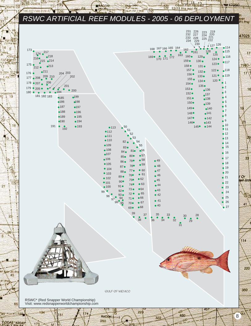
RSWC ARTIFICIAL REEF MODULES - 2005 - 06 DEPLOYMENT
1
2
3
4
5
6
7
8
9
1011
12
13
1415
16
17
18
19
20
21
22
23
24
25
26
27
28
29
30
31
32
33
34
35
36
37
38
39
40
41
42
43
44
45
46
47
48
49
5051
5253
5455
56
57
58
59
6061
62
63
64
65
66
67
6869
70
71
72
73
74
75
76
77
78
79
80
81
82
83
84
85
86
87
88
89
90
91
929394
959697
98
99
100101
102
103
104
105
106
107
108
109
110
111
112
113
114115
116
117
118
119
120
121
122
123
124
125
126127
128
129
130
131
132
133
134
135136
137
138
139
140
141
142
143144145
146
147
148
149
150
151
152
153
154
155
156
157158
159
160
161162
163
164165166167168
169170 171 172
173174
175
176
177
178
179
180181 182 183
184
185186
187
188
189
190
191192
193
194
195
196
197
198
199
200
201
202203204
205
206207
208 209 210
211212 213
214215216
217
218
219220
221222
223
225224
226
228227
229230
231232
234233
GULF OF MEXICOGULF OF MEXICO
RSWC* (Red Snapper World Championship)Visit: www.redsnapperworldchampionship.com
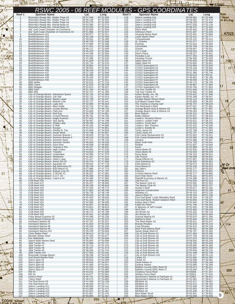
RSWC 2005 - 06 REEF MODULES - GPS COORDINATESReef # Reef #Sponsor Name Sponsor Name Lat.Lat. Long Long
123456789
101112131415161718192021222324252627282930313233343536373839404142434445464748495051525354555657585960616263646566676869707172737475767778798081828384858687888990919293949596979899
100101102103104105106107108109110111112113114115116117
118119120121122123124125126127128129130131132133134135136137138139140141142143144145146147148149150151152153154155156157158159160161162163164165166167168169170171172173174175176177178179180181182183184185186187188189190191192193194195196197198199200201202203204205206207208209210211212213214215216217218219220221222223224225226227228229230231232233234
Reynold's Ready Mix- Walter Pope #2Reynold's Ready Mix- Walter Pope #3Reynold's Ready Mix- Walter Pope #4Reynold's Ready Mix- Harold Butts #2Reynold's Ready Mix- Harold Butts #3Ala° Gulf Coast Chamber of CommerceAla° Gulf Coast Chamber of Commerce #2Brett/Robinson #21Brett/Robinson #22Brett/Robinson #23Brett/Robinson #24Brett/Robinson #25Brett/Robinson #26Brett/Robinson #27Brett/Robinson #28Brett/Robinson #29Brett/Robinson #30Brett/Robinson #31Brett/Robinson #32Brett/Robinson #33Brett/Robinson #34Brett/Robinson #35Brett/Robinson #36Brett/Robinson #37Brett/Robinson #38Brett/Robinson #39Brett/Robinson #40BBD MollieBBD ClaireBBD MaggieBBD SamBBD WillCity of Orange Beach- Adventure QuestCity of Orange Beach- Job SiteCity of Orange Beach- Barely LegalCity of Orange Beach- Bottom LineCity of Orange Beach- Lady AnnCity of Orange Beach- Miss HollieCity of Orange Beach- Condo MoneyCity of Orange Beach- Patti AnnCity of Orange Beach- Red EyeCity of Orange Beach- Crowd PleezerCity of Orange Beach- Eagle ExpressCity of Orange Beach- Sea SprayCity of Orange Beach- Shady LadyCity of Orange Beach- E-MailCity of Orange Beach- EscapeCity of Orange Beach- Shirley R. TooCity of Orange Beach- South WindCity of Orange Beach- Summer Breeze ICity of Orange Beach- Summer Breeze IICity of Orange Beach- Summer DazeCity of Orange Beach- Summer HunterCity of Orange Beach- Sure ShotCity of Orange Beach- Teacher's PetCity of Orange Beach- High CottonCity of Orange Beach- TravelerCity of Orange Beach- UndertakerCity of Orange Beach- WishboneCity of Orange Beach- Zeke's LadyCity of Orange Beach- Annie Girl #2City of Orange Beach- Aquastar #2City of Orange Beach- Big Adventure #2City of Orange Beach- Boll Weevil #2City of Orange Beach- Bottom Line #2City of Orange Beach- C-ROSE #2City of Orange Beach- C.A.T. #2City of Orange Beach- Catch-It #2CVB Reef #16CVB Reef #17CVB Reef #18CVB Reef #19CVB Reef #20CVB Reef #21CVB Reef #22CVB Reef #23CVB Reef #24CVB Reef #25CVB Reef #26CVB Reef #27CVB Reef #28CVB Reef #29CVB Reef #30Foley Beach Express #3Foley Beach Express #4Homeport Marina #6Homeport Marina #7Homeport Marina #8Homeport Marina #9Homeport Marina #10Chris Steber ReefMichele Steber ReefEric MahlstedtIsland Wide Marine ReefJ&M Tackle #6J&M Tackle #7J&M Tackle #8J&M Tackle #9J&M Tackle #10Riverwalk Orange BeachGulf World Marine ParkSam's Spot #3Sam's Spot #4Sam's Spot #5Sam's Spot #6Sam's Spot #7RM #3RM #4Owen's ReefToby's ReefThe Rod Room #3The Rod Room #4Zeke's Landing #11Zeke's Landing #12Zeke's Landing #13Zeke's Landing #14Zeke's Landing #15
29°57.04629°56.13929°55.27529°54.38529°53.53529°52.69329°51.86629°50.97729°50.10829°49.26129°48.79329°47.89029°47.02129°46.11129°45.24229°44.34829°43.41229°42.48629°41.63929°40.73429°39.89129°38.93429°38.10929°37.15929°36.30629°35.44529°34.55129°32.52229°32.52529°32.61329°31.76429°32.75729°32.73429°32.72229°32.72829°32.72729°32.69029°32.72329°32.77629°34.80629°35.73929°36.78129°37.62329°38.48729°39.32829°40.19229°41.07229°41.94929°42.79829°48.92929°48.21929°47.47129°46.92629°46.09929°45.42729°44.69229°43.81629°42.99029°42.18729°41.31729°40.47429°39.64229°38.74929°37.88629°36.93529°36.20729°35.35829°34.48929°34.48129°35.32729°36.19829°37.03329°37.86229°38.73529°39.53229°40.40329°41.24429°42.08529°42.95729°43.81529°44.72629°46.27229°45.34129°44.49629°43.61329°42.76729°41.82329°40.93429°40.12229°39.24929°38.41329°37.53529°36.72229°35.85429°34.99929°35.71029°36.35729°36.93629°37.56229°38.19629°39.02029°39.81929°40.64329°41.48329°42.32329°43.16529°44.03129°44.87729°45.74129°46.57429°47.40829°48.29429°48.96930°03.38030°02.50730°01.65730°00.805
87°32.60587°32.55487°32.59587°32.57487°32.54487°32.56487°32.54787°32.52187°32.56487°32.46587°32.55887°32.48687°32.54887°32.60987°32.56487°32.58387°32.64387°32.53687°32.53187°32.51087°32.57487°32.58487°32.57387°32.66987°32.63387°32.59787°32.55187°37.21087°38.32887°39.34787°40.32187°41.39487°42.48087°43.51487°44.44787°45.44187°46.56387°47.66187°48.75487°44.78987°44.80187°44.78487°44.74287°44.78887°44.83387°44.86687°44.86187°44.83487°44.85787°50.74087°50.24587°49.73287°49.25087°48.68287°48.09187°47.53587°47.52987°47.57887°47.61487°47.60687°47.69087°47.71887°47.66887°47.71387°47.78787°47.80287°47.80387°47.86087°48.80587°48.80687°48.81887°48.77287°48.75887°48.74987°48.74587°48.82587°48.71087°48.69687°48.66287°48.64387°48.48487°49.78887°49.86587°50.15687°50.22287°50.25787°50.32987°50.23087°50.58087°50.60987°50.71587°50.67787°50.68487°50.69987°50.73787°51.37587°51.97387°52.70487°53.44487°54.02987°54.06987°54.05987°54.02787°53.94187°53.96487°53.98087°53.90987°53.96187°53.86087°53.80587°53.76987°53.77187°53.14187°32.47187°32.46787°32.47587°32.467
Zeke's Landing #16Zeke's Landing #17Zeke's Landing #18Zeke's Landing #19Zeke's Landing #20Red's ReefAnthony's ReefAmanda Myers ReefLeslie Myers ReefTchuopitoulasSt. CharlesPoydrasCarondoletGravierJ.D.'s HolePeet's PlaceParadise LostParadise FoundSabel Steel #3Sabel Steel #4CITGO Supergard #1CITGO Supergard #2CITGO Supergard #3CITGO Supergard #4CITGO Supergard #5CITGO Supergard #6CITGO Supergard #7CITGO Supergard #8CITGO Supergard #9CITGO Supergard #10Top Gun Tackle #3Top Gun Tackle #4Kaiser Realty, Inc. #6Kaiser Realty, Inc. #7Perdido Beach Resort ReefGulf Beach Hotels ReefThe Champ & Chump reefThe Wickware's ReefOrange Beach Auto & Marine #3Orange Beach Auto & Marine #4Boss MaloufBailey MaloufLester's- Houston PierceLester's- Leslee FaithLester's- Uncle BudLester's- Mrs TheresaLester's- Estelle M.Tacky Jacks #3Tacky Jacks #4Fish Camp Restaurants #3Fish Camp Restaurants #4VoodooBlack Gold HoleRobbieKevinVision Bank #3Vision Bank #4Dizzy BeanLilly FrenchVisual Effects #2Vinyl Solutions #2Flora-Bama IIIFlora-Bama IVBig Jake'sFrancosX-treme Marine ReefDon't Fish Here!Radcliff Economy & Marine #2ValvTect #2The Beach Club #1The Beach Club #2Hunter's ReefHyperion ConstructionWadeley #1Jason's Reef 21First Gulf Bank- Linda Wheatley ReefFirst Gulf Bank- Robert Seaborn ReefKelsey Mac's ReefKaitlin B's ReefIn Memory of Jeff CooperWe'll SeeJim Brown #2Jim Brown #3Outcast Marina #3Mathew's ReefThe Reef Maker #3Brandy RhodesCody RhodesBear Point Marina ReefSandy Wade Reef #2City of Gulf Shores #1City of Gulf Shores #2City of Gulf Shores #3City of Gulf Shores #4City of Gulf Shores #5City of Gulf Shores #6City of Gulf Shores #7City of Gulf Shores #8City of Gulf Shores #9City of Gulf Shores #10Caribe #3Caribe #4David Askew Jr.Earlene AskewBaldwin County EMC Reef #6Baldwin County EMC Reef #7Charlene Farve ReefShelley Farve ReefSportsman's Marine in Fairhope #1Sportsman's Marine in Fairhope #2RE/MAX #1RE/MAX #2RE/MAX #3RE/MAX #4RE/MAX #5Blue Water ScottBlue Water Chris
29°99.96129°59.08329°58.22629°57.53029°58.37530°00.45230°01.30730°02.59130°03.41230°03.12230°02.27730°01.61630°00.78429°59.94729°59.05229°58.22729°57.34329°56.48329°55.64529°54.80029°53.96529°53.12829°52.31929°51.48629°50.61929°49.80229°49.09329°49.17229°49.88729°50.76029°51.64929°52.58229°53.42229°54.26829°55.11329°55.95929°56.75729°57.62729°47.48229°59.36330°00.10130°00.92730°01.82030°02.62130°02.54230°02.42230°02.87630°02.78830°02.70730°02.65230°02.56530°01.68630°01.75930°01.83730°02.08930°02.92030°02.04330°00.15329°58.69829°57.80729°56.92529°56.07429°55.23029°55.17729°55.17129°55.17729°55.14129°54.38929°53.52029°52.59129°51.70329°50.87729°50.01529°49.14329°49.16429°49.15429°50.05629°50.90429°51.79029°52.64029°53.48229°54.33229°55.67029°55.87029°55.69229°55.91129°55.91929°55.91529°56.64129°56.78729°57.48329°57.70929°57.67029°58.95529°59.76029°59.95030°00.84630°00.60630°01.44830°02.12730°01.60530°03.09830°03.05830°03.08530°03.07430°03.06030°0305630°0305130°0295230°02.98130°02.97130°02.97230°02.93830°02.95330°02.93830°02.94130°02.958
87°32.49687°32.47987°32.49087°33.12987°33.44087°33.45087°33.43587°33.80687°33.77787°35.41487°35.37387°36.00587°36.20487°35.93187°35.93087°35.92187°35.94687°35.92987°35.95687°35.96187°35.94387°35.90487°35.59087°35.74687°3571687°35.78087°35.73787°36.75987°37.89487°37.90487°37.87587°37.86887°37.94687°38.00787°38.04987°38.29387°38.03487°37.89187°37.89787°37.91287°38.42087°38.53487°38.21187°38.10787°39.25687°40.20687°41.00287°41.99387°42.94087°44.02187°45.03687°45.00787°44.04187°43.06487°42.10188°06.85388°06.04988°06.81488°06.84288°06.83688°06.86288°06.81688°06.82388°05.83288°04.85188°03.86088°02.87088°02.37988°02.32388°02.30288°02.22788°02.16288°02.19088°02.13088°01.19687°59.20787°59.20987°59.28487°59.34087°59.36987°59.42887°59.71988°00.36488°01.30688°02.31588°03.24788°04.21988°05.23888°04.36888°05.26088°05.29088°04.44988°03.54588°05.25888°05.63988°04.26088°04.20888°05.73288°05.70988°05.11088°04.35987°36.08187°36.16887°36.28987°36.42187°37.25787°37.33787°37.54387°38.55187°38.61787°38.69787°38.78387°38.93287°39.47087°39.52787°39.93287°40.050 9
10
RSWC* ARTIFICIAL REEF MODULES - 2007 - 08 DEPLOYMENT
215
GULF OF MEXICOGULF OF MEXICO
216
217
218
219
220
221222
223
224
225
226
227228229
230231
232233
234
235
236
356
357
358359
360361
362
363364
365
366
367
368
369
370
371
372
373
374
375376
377378
379
380
381
382
383
384
385
346
347
348
349350
351
352353
354355
317386
387388
389390
391392
393394
395396
397
398399
400401
402
403404
405
406
306307
308309
310311
312313
314315
316
212
213
214
205
206
207
208
210209 211
197
198199
200
201
202
203
204 190191
192
193194
195
196
181
182
183
184
185
186
187
188
189
237
238
239
240
241
242
243
244
245
246247
248
249
250
251
252
253
254
255
266
267
268
269
270271
272
273274
275
276
277
278
279
280
281
282
283
284285
256
257
258
259
260
261
262263
264
265
286287
288289
290
291292
293
294
295
296
297
298
299
300
301302
303
304305
RSWC* (Red Snapper World Championship)Visit: www.redsnapperworldchampionship.com
RSWC 2007 REEF MODULES - GPS COORDINATESReef # Reef #Sponsor Name Sponsor Name Lat.Lat. Long Long
123456789
101112131415161718192021222324252627282930313233343536373839404142434445464748495051525354555657585960616263646566676869707172737475767778798081828384858687888990919293949596979899
100101102103104105106107108109110111112113114115116117
118119120121122123124125126127128129130131132133134135136137138139140141142143144145146147148149150151152153154155156157158159160161162163164165166167168169170171172173174175176177178179180181182183184185186187188189190191192193194195196197198199200201202203204205206207208209210211212213214215216217218219220221222223224225226227228229230231232233234
Fish Camp Restaurant #6Foley Beach Express #5Foley Beach Express #6Foley Beach Express #7Foley Beach Express #8Xtreme Marine #2Xtreme Marine #3Xtreme Marine #4Xtreme Marine #5Galati Yacht Sales #1Galati Yacht Sales #2Galati Yacht Sales #3Jason Collings ReefGary Finch Outdoors #1Gary Finch Outdoors #2Katelyn FinchChristopher FinchLaura LaytonEmily LaytonGeno’s ReefWilliam Wyatt ReefGeorge's Water Sports #1George's Water Sports #2Glass Inc. #1Glass Inc. #2Gulf Shores Yacht Club & Marine #1Gulf Shores Yacht Club & Marine #2Gulf Shores Yacht Club & Marine #3Gulf Shores Yacht Club & Marine #4Gulf States Ready Mix #1Gulf States Ready Mix #2Guy Harvey #1Guy Harvey #2Guy Harvey #3Guy Harvey #4Hi-LinerEdward R. GawTim GawBrooke LampingInternational Assurance #1International Assurance #2International Assurance #3International Assurance #4Island House Hotel #1Island House Hotel #2Island House Hotel #3Island House Hotel #4Carol MahlstedtC.J.'s ReefIsland Wide Marine Reef #2Island Wide Marine Reef #3Isle of Capri #1Isle of Capri #2Isle of Capri #3Isle of Capri #4J&M Tackle #11J&M Tackle #12J&M Tackle #13J&M Tackle #14J&M Tackle #15J&M Tackle #16J&M Tackle #17J&M Tackle #18J&M Tackle #19J&M Tackle #20JetCenter SouthPhil MartinBobCopy ThatJim Brown #4Jim Brown #5Joe Raley Builders #1Joe Raley Builders #2Kaiser Realty #8Kaiser Realty #9Kaiser Realty #10Kaiser Realty #11Kaiser Realty #12Kaiser Realty #13Lamar #1Lamar #2Lamar #3Lamar #4Micah Cassaday #1Micah Cassaday #2Millicent Cassaday #1Millicent Cassaday #2Live BaitLive Bait IILive Bait at The WharfLive Bait CateringFlora-Bama VHomeport Marina #11Homeport Marina #12Flora-Bama VIDanatana ReefSam Solomon Memorial ReefMcCarron Insurance Group #2Malouf #2Malouf #1Flora-Bama VIIFlora-Bama VIIILegendary Marine #1Legendary Marine #2Legendary Marine #3Legendary Marine #4Legendary Marine #5Legendary Marine #6Century Boats #1Century Boats #2Century Boats #3Century Boats #4Century Boats #5Century Boats #6Lester's Restaurant #1Lester's Restaurant #2Lester's Restaurant #3
AFTCO #1AFTCO #2AFTCO #3AFTCO #4Baldwin EMC #8Baldwin EMC #9Baldwin EMC #10Baldwin EMC #11Baldwin EMC #12Baldwin EMC #13Bender Shipyards #1Bender Shipyards #2Bender Shipyards #3Bender Shipyards #4Doc's Seafood ShackBubba'sJake's SteakhouseFranco's ItalianBlue Water John #1Blue Water John #2Brett/Robinson #41Brett/Robinson #42Brett/Robinson #43Brett/Robinson #44Brett/Robinson #45Brett/Robinson #46BBD-DaveBBD-MarvinBBD-JoeBBD-MarlinBBD-PhilBBD-TonyBBD-WarrenBBD-HerbertCaribe #5Caribe #6Caribe #7Caribe #8Center Coal Co. #1Center Coal Co. #2Ala. Gulf Coast Chamber of Comm. #3Ala. Gulf Coast Chamber of Comm. #4Ala. Gulf Coast Chamber of Comm. #5Ala. Gulf Coast Chamber of Comm. #6Leslie MyersAmanda MyersChristian Life Church #1Christian Life Church #2Christian Life Church #3Christian Life Church #4City of Gulf Shores Johnnie Sims ReefCity of Gulf Shores Claude O'Connor ReefCity of Gulf Shores Clarence Horton ReefCity of Gulf Shores Eugene Ingram ReefCity of Gulf Shores Mixon Jones ReefCity of Gulf Shores Thom. Norton, M.D. ReefCity of Gulf Shores David Bodenhamer ReefCity of Gulf Shores G.W. "Billy" Duke ReefCity of Orange BeachCity of Orange BeachCity of Orange BeachCity of Orange BeachCity of Orange BeachCity of Orange BeachCity of Orange BeachCity of Orange BeachCity of Orange BeachCity of Orange BeachCity of Orange BeachCity of Orange BeachCity of Orange BeachCity of Orange BeachCity of Orange BeachCity of Orange BeachCity of Orange BeachCity of Orange BeachCVB Reef #31CVB Reef #32CVB Reef #33CVB Reef #34CVB Reef #35CVB Reef #36CVB Reef #37CVB Reef #38CVB Reef #39CVB Reef #40CVB Reef #41CVB Reef #42CVB Reef #43CVB Reef #44CVB Reef #45CVB Reef #46CVB Reef #47CVB Reef #48CVB Reef #49CVB Reef #50CVB Reef #51CVB Reef #52CVB Reef #53CVB Reef #54CVB Reef #55CVB Reef #56CVB Reef #57CVB Reef #58CVB Reef #59CVB Reef #60DI MaryDI KatherineDI TripDI AlisonDI AnnaDI AllisonDI RichardDI LyndsayEdgewaterZarina BellaFish Camp Restaurant #5 11
30°08.86630°08.86730°08.87630°08.87830°08.89330°08.89230°08.89030°08.88830°08.88430°08.88030°08.87630°08.87430°08.87230°08.86230°08.85930°08.85530°08.85030°08.84730°08.84230°08.83730°08.83230°08.82930°08.81730°08.80830°08.80530°08.80230°08.79630°08.78830°08.78530°08.76930°08.76330°08.76130°08.75930°08.75030°08.74930°08.74730°08.74330°08.74730°08.75730°08.75730°08.73630°08.73530°08.73630°08.73730°08.73830°08.73930°08.73930°08.74030°08.74130°08.74430°08.74730°08.75730°08.75730°08.75330°08.75030°08.74930°08.74930°08.74730°08.74830°08.74930°08.73830°08.73730°08.73530°08.73030°08.73330°08.73330°08.73030°08.72430°08.71930°08.73130°08.71830°08.72030°08.71630°08.71730°08.72230°08.71730°08.72130°08.71630°08.72030°08.72130°08.71630°08.71830°08.71830°08.71730°08.71730°08.71530°08.71430°08.71530°08.71530°08.71430°08.70730°08.71730°08.71430°08.71130°08.71030°08.70830°08.70930°08.70830°08.70730°08.70730°08.70630°08.70830°08.71030°08.70230°08.69830°08.69930°08.69030°08.68330°08.67530°08.66830°08.66030°08.64830°08.62730°08.61530°08.60630°08.60130°08.597
87°34.17587°34.18287°34.22287°34.22687°34.31487°34.30487°34.28987°34.27087°34.25387°34.23987°34.22187°34.20987°34.18987°34.15287°34.13687°34.12487°34.10787°34.08287°34.05987°34.03987°34.02187°33.99887°33.95387°33.92187°33.90987°33.89987°33.86687°33.84287°33.83087°33.77687°33.75887°33.74987°33.74387°33.70787°33.69087°33.68187°33.65787°33.65987°33.64087°33.62987°33.43087°33.44187°33.44387°33.45387°33.45787°33.46687°33.47487°33.47887°33.48587°33.50887°33.53387°33.61487°33.60787°33.60787°33.58987°33.57987°33.57087°33.55987°33.55287°33.54087°33.43087°33.42187°33.41587°33.40087°33.38987°33.37787°33.37287°33.37187°33.35587°33.34187°33.31687°33.29887°33.28787°33.27187°33.25987°33.24087°33.22087°33.20387°33.18487°33.17287°33.15287°33.14487°33.13687°33.12787°33.11587°33.10187°33.07387°33.06587°33.05187°33.04287°33.01687°33.00087°32.98187°32.95887°32.93687°32.92087°32.90587°32.89187°32.88087°32.86687°32.85887°32.84787°32.84087°32.82187°32.81287°32.81587°32.80287°32.79387°32.78487°32.77787°32.76987°32.75587°32.73487°32.72187°32.71087°32.70387°32.696
87°32.68487°32.67287°32.66687°32.63987°32.63287°32.61987°32.61087°32.59987°32.58787°32.57687°32.56487°32.55587°32.54787°32.54187°32.53487°32.52987°32.52187°32.51387°32.50587°32.49687°32.48587°32.47687°32.46987°32.45987°32.44287°32.43087°32.41587°32.40287°32.39087°32.38187°32.36987°32.36287°32.35587°32.34987°32.34187°32.33687°32.33287°32.32587°32.31287°32.29687°32.28287°32.27587°32.27487°32.26687°32.25787°32.25087°32.24287°32.23287°32.22287°32.21187°32.19787°32.18387°32.17287°32.16387°32.15387°32.14287°32.12987°32.11787°32.10787°32.09887°32.08687°32.07987°32.07687°45.60887°45.62487°45.59687°45.59687°45.57787°46.55787°46.31487°46.38987°46.46187°47.38687°47.33587°47.38487°47.32087°47.78187°48.25987°48.25587°48.20687°48.21287°48.96787°48.98887°48.75087°50.12687°50.17087°50.25087°51.63687°51.30187°50.85487°50.24587°49.55987°48.31287°47.60287°47.56687°47.52787°47.32187°56.45387°57.56587°57.85787°58.22887°58.69387°59.10787°59.60688°00.71888°00.58187°59.20487°59.28587°59.01287°57.96288°00.06288°00.94488°00.98088°01.14988°01.18388°02.26688°02.713
30°08.58130°08.57030°08.55930°08.54530°08.53630°08.52630°08.51730°08.50730°08.49730°08.48630°08.47730°08.46930°08.46230°08.45630°08.45130°08.44730°08.43930°08.43230°08.42530°08.41730°08.40730°08.39930°08.39230°08.38230°08.37030°08.36030°08.34630°08.33630°08.32330°08.31630°08.30730°08.30030°08.29430°08.29030°08.28330°08.27830°08.27230°08.26530°08.25430°08.24130°08.22530°08.21230°08.20530°08.21530°08.20730°08.20130°08.19530°08.18530°08.17530°08.16530°08.15230°08.14030°08.13030°08.12230°08.11230°08.10230°08.09130°08.08130°08.07230°08.06030°08.05130°08.04230°08.03130°02.49730°01.72530°01.03229°58.89029°58.12429°59.27430°00.44330°01.01030°01.73230°02.35030°01.72930°01.00530°00.36629°59.84230°00.43030°01.00830°01.71030°02.27030°02.22430°01.66229°59.79530°00.66430°01.45830°02.16730°02.07230°01.37730°00.43929°59.62629°58.68229°58.78529°58.78129°57.89029°56.83929°55.66429°55.89729°58.21629°59.09829°59.85430°00.65030°01.48430°02.39930°02.43830°01.56729°58.72029°57.75829°57.03029°56.16729°56.15829°56.18529°56.97029°57.65929°58.46229°59.19329°59.800
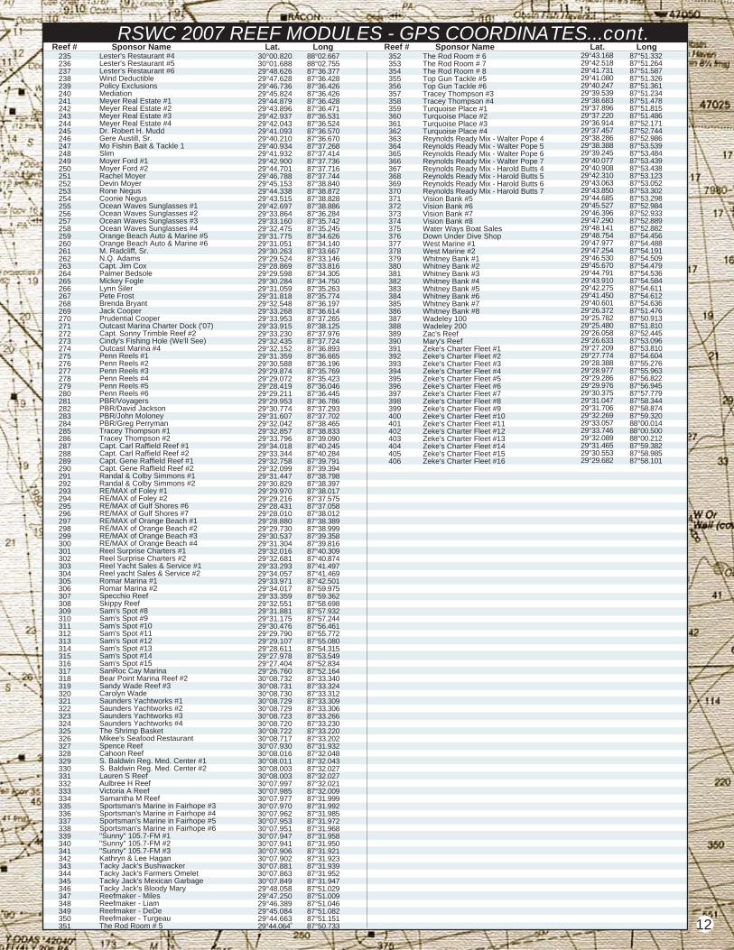
RSWC 2007 REEF MODULES - GPS COORDINATES...cont.Reef # Reef #Sponsor Name Sponsor Name Lat.Lat. Long Long
235236237238239240241242243244245246247248249250251252253254255256257258259260261262263264265266267268269270271272273274275276277278279280281282283284285286287288289290291292293294295296297298299300301302303304305306307308309310311312313314315316317318319320321322323324325326327328329330331332333334335336337338339340341342343344345346347348349350351
352353354355356357358359360361362363364365366367368369370371372373374375376377378379380381382383384385386387388389390391392393394395396397398399400401402403404405406
30°00.82030°01.68829°48.62629°47.62829°46.73629°45.82429°44.87929°43.89629°42.93729°42.04329°41.09329°40.21029°40.93429°41.93229°42.90029°44.70129°46.78829°45.15329°44.33829°43.51529°42.69729°33.86429°33.16029°32.47529°31.77529°31.05129°30.26329°29.52429°28.86929°29.59829°30.28429°31.05929°31.81829°32.54829°33.26829°33.95329°33.91529°33.23029°32.43529°32.15229°31.35929°30.58829°29.87429°29.07229°28.41929°29.21129°29.95329°30.77429°31.60729°32.04229°32.85729°33.79629°34.01829°33.34429°32.75829°32.09929°31.44729°30.82929°29.97029°29.21629°28.43129°28.01029°28.88029°29.73029°30.53729°31.30429°32.01629°32.68129°33.29329°34.05729°33.97129°34.01729°33.35929°32.55129°31.88129°31.17529°30.47629°29.79029°29.10729°28.61129°27.97829°27.40429°26.76030°08.73230°08.73130°08.73030°08.72930°08.72930°08.72330°08.72030°08.72230°08.71730°07.93030°08.01630°08.01130°08.00330°08.00330°07.99730°07.98530°07.97730°07.97030°07.96230°07.95330°07.95130°07.94730°07.94130°07.90630°07.90230°07.88130°07.86330°07.84929°48.05829°47.25029°46.38929°45.08429°44.66329°44.064
88°02.66788°02.75587°36.37787°36.42887°36.42687°36.42687°36.42887°36.47187°36.53187°36.52487°36.57087°36.67087°37.26887°37.41487°37.73687°37.71687°37.74487°38.84087°38.87287°38.82887°38.88687°36.28487°35.74287°35.24587°34.62687°34.14087°33.66787°33.14687°33.81687°34.30587°34.75087°35.26387°35.77487°36.19787°36.61487°37.26587°38.12587°37.97687°37.72487°36.89387°36.66587°36.19687°35.76987°35.42387°36.04687°36.44587°36.78687°37.29387°37.70287°38.46587°38.83387°39.09087°40.24587°40.28487°39.79187°39.39487°38.79887°38.39787°38.01787°37.57587°37.05887°38.01287°38.38987°38.99987°39.35887°39.81687°40.30987°40.87487°41.49787°41.46987°42.50187°59.97587°59.36287°58.69887°57.93287°57.24487°56.46187°55.77287°55.08087°54.31587°53.54987°52.83487°52.16487°33.34087°33.32487°33.31287°33.30987°33.30687°33.26687°33.23087°33.22087°33.20287°31.93287°32.04887°32.04387°32.02787°32.02787°32.02187°32.00987°31.99987°31.99287°31.98587°31.97287°31.96887°31.95887°31.95087°31.92187°31.92387°31.93987°31.95287°31.94787°51.02987°51.00987°51.04687°51.08287°51.15187°50.733
The Rod Room # 6The Rod Room # 7The Rod Room # 8Top Gun Tackle #5Top Gun Tackle #6Tracey Thompson #3Tracey Thompson #4Turquoise Place #1Turquoise Place #2Turquoise Place #3Turquoise Place #4Reynolds Ready Mix - Walter Pope 4Reynolds Ready Mix - Walter Pope 5Reynolds Ready Mix - Walter Pope 6Reynolds Ready Mix - Walter Pope 7Reynolds Ready Mix - Harold Butts 4Reynolds Ready Mix - Harold Butts 5Reynolds Ready Mix - Harold Butts 6Reynolds Ready Mix - Harold Butts 7Vision Bank #5Vision Bank #6Vision Bank #7Vision Bank #8Water Ways Boat SalesDown Under Dive ShopWest Marine #1West Marine #2Whitney Bank #1Whitney Bank #2Whitney Bank #3Whitney Bank #4Whitney Bank #5Whitney Bank #6Whitney Bank #7Whitney Bank #8Wadeley 100Wadeley 200Zac's ReefMary's ReefZeke's Charter Fleet #1Zeke's Charter Fleet #2Zeke's Charter Fleet #3Zeke's Charter Fleet #4Zeke's Charter Fleet #5Zeke's Charter Fleet #6Zeke's Charter Fleet #7Zeke's Charter Fleet #8Zeke's Charter Fleet #9Zeke's Charter Fleet #10Zeke's Charter Fleet #11Zeke's Charter Fleet #12Zeke's Charter Fleet #13Zeke's Charter Fleet #14Zeke's Charter Fleet #15Zeke's Charter Fleet #16
87°51.33287°51.26487°51.58787°51.32687°51.36187°51.23487°51.47887°51.81587°51.48687°52.17187°52.74487°52.98687°53.53987°53.48487°53.43987°53.43887°53.12387°53.05287°53.30287°53.29887°52.98487°52.93387°52.88987°52.88287°54.45687°54.48887°54.19187°54.50987°54.47987°54.53687°54.58487°54.61187°54.61287°54.63687°51.47687°50.91387°51.81087°52.44587°53.09687°53.81087°54.60487°55.27687°55.96387°56.82287°56.94587°57.77987°58.34487°58.87487°59.32088°00.01488°00.50088°00.21287°59.38287°58.98587°58.101
29°43.16829°42.51829°41.73129°41.08029°40.24729°39.53929°38.68329°37.89629°37.22029°36.91429°37.45729°38.28629°38.38829°39.24529°40.07729°40.90829°42.31029°43.06329°43.85029°44.68529°45.52729°46.39629°47.29029°48.14129°48.75429°47.97729°47.25429°46.53029°45.67029°44.79129°43.91029°42.27529°41.45029°40.60129°26.37229°25.78229°25.48029°26.05829°26.63329°27.20929°27.77429°28.38829°28.97729°29.28629°29.97629°30.37529°31.04729°31.70629°32.26929°33.05729°33.74629°32.08929°31.46529°30.55329°29.682
Lester's Restaurant #4Lester's Restaurant #5Lester's Restaurant #6Wind DeductiblePolicy ExclusionsMediationMeyer Real Estate #1Meyer Real Estate #2Meyer Real Estate #3Meyer Real Estate #4Dr. Robert H. MuddGere Austill, Sr.Mo Fishin Bait & Tackle 1SlimMoyer Ford #1Moyer Ford #2Rachel MoyerDevin MoyerRone NegusCoonie NegusOcean Waves Sunglasses #1Ocean Waves Sunglasses #2Ocean Waves Sunglasses #3Ocean Waves Sunglasses #4Orange Beach Auto & Marine #5Orange Beach Auto & Marine #6M. Radcliff, Sr.N.Q. AdamsCapt. Jim CoxPalmer BedsoleMickey FogleLynn SilerPete FrostBrenda BryantJack CooperPrudential CooperOutcast Marina Charter Dock ('07)Capt. Sonny Trimble Reef #2Cindy's Fishing Hole (We'll See)Outcast Marina #4Penn Reels #1Penn Reels #2Penn Reels #3Penn Reels #4Penn Reels #5Penn Reels #6PBR/VoyagersPBR/David JacksonPBR/John MoloneyPBR/Greg PerrymanTracey Thompson #1Tracey Thompson #2Capt. Carl Raffield Reef #1Capt. Carl Raffield Reef #2Capt. Gene Raffield Reef #1Capt. Gene Raffield Reef #2Randal & Colby Simmons #1Randal & Colby Simmons #2RE/MAX of Foley #1RE/MAX of Foley #2RE/MAX of Gulf Shores #6RE/MAX of Gulf Shores #7RE/MAX of Orange Beach #1RE/MAX of Orange Beach #2RE/MAX of Orange Beach #3RE/MAX of Orange Beach #4Reel Surprise Charters #1Reel Surprise Charters #2Reel Yacht Sales & Service #1Reel yacht Sales & Service #2Romar Marina #1Romar Marina #2Specchio ReefSkippy ReefSam's Spot #8Sam's Spot #9Sam's Spot #10Sam's Spot #11Sam's Spot #12Sam's Spot #13Sam's Spot #14Sam's Spot #15SanRoc Cay MarinaBear Point Marina Reef #2Sandy Wade Reef #3Carolyn WadeSaunders Yachtworks #1Saunders Yachtworks #2Saunders Yachtworks #3Saunders Yachtworks #4The Shrimp BasketMikee's Seafood RestaurantSpence ReefCahoon ReefS. Baldwin Reg. Med. Center #1S. Baldwin Reg. Med. Center #2Lauren S ReefAulbree H ReefVictoria A ReefSamantha M ReefSportsman's Marine in Fairhope #3Sportsman's Marine in Fairhope #4Sportsman's Marine in Fairhope #5Sportsman's Marine in Fairhope #6"Sunny" 105.7-FM #1"Sunny" 105.7-FM #2"Sunny" 105.7-FM #3Kathryn & Lee HaganTacky Jack's BushwackerTacky Jack's Farmers OmeletTacky Jack's Mexican GarbageTacky Jack's Bloody MaryReefmaker - MilesReefmaker - LiamReefmaker - DeDeReefmaker - TurgeauThe Rod Room # 5 12
GULF OF MEXICOGULF OF MEXICO
DON KELLEY SOUTH
GENERALPERMIT AREA
TATUM - WINNNORTH
GENERALPERMIT AREA
DON KELLEYNORTH
GENERALPERMITAREA
TATUM - WINNSOUTH
GENERAL PERMIT AREA
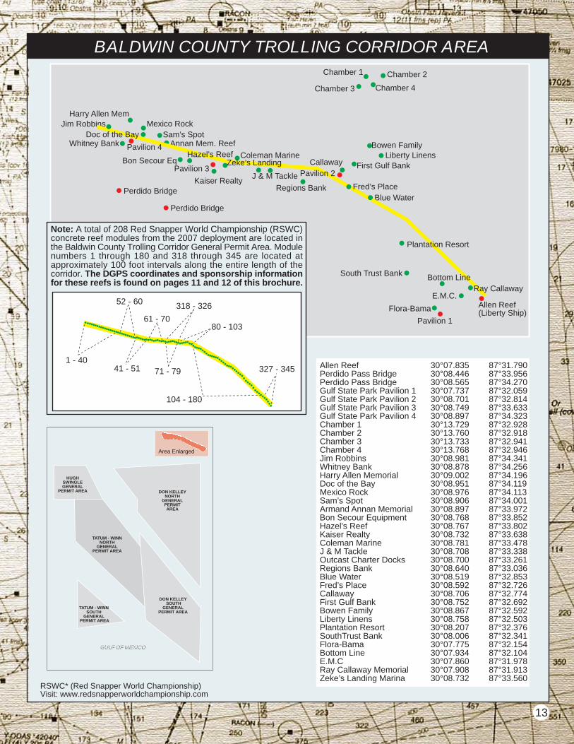
BALDWIN COUNTY TROLLING CORRIDOR AREA
Liberty Linens
Blue Water
Chamber 1
Flora-Bama
E.M.C.
South Trust Bank
Harry Allen MemJim Robbins
First Gulf Bank
Bowen Family
Callaway
Mexico Rock
Annan Mem. Reef
Bon Secour EqColeman Marine
Kaiser RealtyJ & M Tackle
Regions Bank
Allen Reef(Liberty Ship)
Perdido Bridge
Perdido Bridge
Whitney Bank
Chamber 2
Chamber 3 Chamber 4
Pavilion 3
Pavilion 1
HUGHSWINGLEGENERAL
PERMIT AREA
Allen Reef 30°07.835 87°31.790Perdido Pass Bridge 30°08.446 87°33.956Perdido Pass Bridge 30°08.565 87°34.270Gulf State Park Pavilion 1 30°07.737 87°32.059Gulf State Park Pavilion 2 30°08.701 87°32.814Gulf State Park Pavilion 3 30°08.749 87°33.633Gulf State Park Pavilion 4 30°08.897 87°34.323Chamber 1 30°13.729 87°32.928Chamber 2 30°13.760 87°32.918Chamber 3 30°13.733 87°32.941Chamber 4 30°13.768 87°32.946Jim Robbins 30°08.981 87°34.341Whitney Bank 30°08.878 87°34.256Harry Allen Memorial 30°09.002 87°34.196Doc of the Bay 30°08.951 87°34.119Mexico Rock 30°08.976 87°34.113Sam’s Spot 30°08.906 87°34.001Armand Annan Memorial 30°08.897 87°33.972Bon Secour Equipment 30°08.768 87°33.852Hazel's Reef 30°08.767 87°33.802Kaiser Realty 30°08.732 87°33.638Coleman Marine 30°08.781 87°33.478J & M Tackle 30°08.708 87°33.338Outcast Charter Docks 30°08.700 87°33.261Regions Bank 30°08.640 87°33.036Blue Water 30°08.519 87°32.853Fred’s Place 30°08.592 87°32.726Callaway 30°08.706 87°32.774First Gulf Bank 30°08.752 87°32.692Bowen Family 30°08.867 87°32.592Liberty Linens 30°08.758 87°32.503Plantation Resort 30°08.207 87°32.376SouthTrust Bank 30°08.006 87°32.341Flora-Bama 30°07.775 87°32.154Bottom Line 30°07.934 87°32.104E.M.C 30°07.860 87°31.978Ray Callaway Memorial 30°07.908 87°31.913Zeke’s Landing Marina 30°08.732 87°33.560
13
Note: A total of 208 Red Snapper World Championship (RSWC)concrete reef modules from the 2007 deployment are located inthe Baldwin County Trolling Corridor General Permit Area. Modulenumbers 1 through 180 and 318 through 345 are located atapproximately 100 foot intervals along the entire length of thecorridor. The DGPS coordinates and sponsorship informationfor these reefs is found on pages 11 and 12 of this brochure.
Plantation Resort
Ray Callaway
Fred’s Place
Sam’s Spot
Hazel’s ReefZeke’s Landing
Bottom Line
Pavilion 2
Doc of the Bay
Pavilion 4
1 - 40
52 - 60
41 - 51
61 - 70
71 - 79
318 - 326
80 - 103
104 - 180
327 - 345
RSWC* (Red Snapper World Championship)Visit: www.redsnapperworldchampionship.com
Area Enlarged
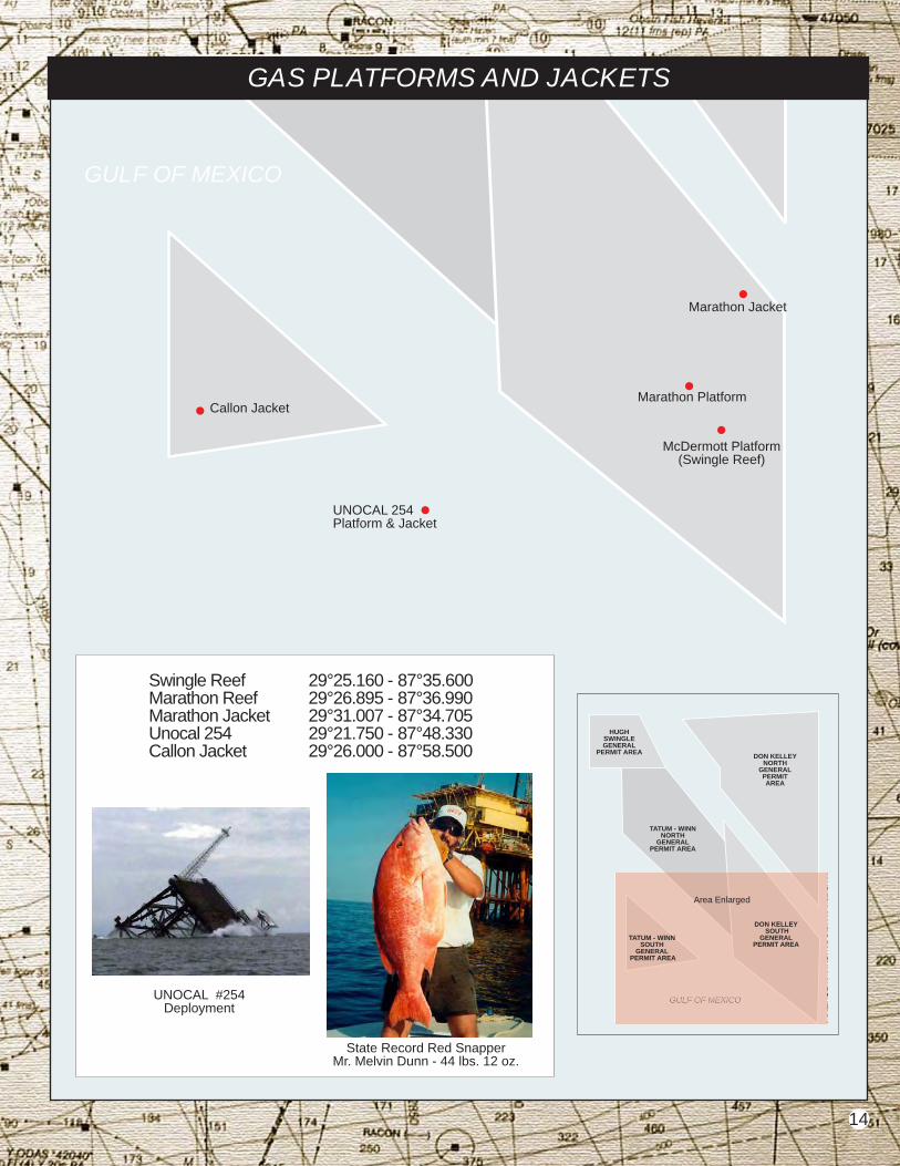
Swingle Reef 29°25.160 - 87°35.600Marathon Reef 29°26.895 - 87°36.990 Marathon Jacket 29°31.007 - 87°34.705 Unocal 254 29°21.750 - 87°48.330Callon Jacket 29°26.000 - 87°58.500
McDermott Platform(Swingle Reef)
Marathon Jacket
Marathon Platform
UNOCAL 254Platform & Jacket
Callon Jacket
GAS PLATFORMS AND JACKETS
GULF OF MEXICO
State Record Red SnapperMr. Melvin Dunn - 44 lbs. 12 oz.
UNOCAL #254Deployment
GULF OF MEXICOGULF OF MEXICO
TATUM - WINNNORTH
GENERALPERMIT AREA
DON KELLEYNORTH
GENERALPERMITAREA
GULF OF MEXICOGULF OF MEXICO
DON KELLEY SOUTH
GENERALPERMIT AREA
TATUM - WINNSOUTH
GENERAL PERMIT AREA
Area Enlarged
HUGHSWINGLEGENERAL
PERMIT AREA
14
INSHORE FISHING REEFS
obile Bay’s ample surface area – about 450 square miles – and its shallow waters... coupled with the influx of copious amounts of freshwater and nutrients from rivers and tributaries, produce some of the very best saltwater gamefish populations to be found anywhere. Speckled trout and white trout,redfish and black drum, sheepshead and flounder all abound in local waters. Head to one of Alabama’s 21inshore artificial fishing reefs and there you will find an inshore fishing experience that is second to none onthe Gulf Coast.
Prior to the construction of formal fish attractors in Mobile Bay, knowledgeable local fishermen understoodand appreciated the community relationship between the Bay’s prolific oyster reefs and exploitable fishpopulations. First, there’s something structurally different about an oyster reef from the surrounding sandand mud bottoms. Oyster reefs are usually raised ever so slightly above the surrounding aquatic terrain,providing linear habitat and home range anchors for schools of predatory fish. This reef structure would attractschools of fish even if devoid of biological activity. But an oyster reef is anything but devoid of life. In additionto the oysters, dozens of types of aquatic invertebrates call the “nooks and crannies” of the oyster reef home,filling each biological niche. Barnacles, mussels, worms and bryozoans, along with a variety of crabs andshrimp abound, taking advantage of the large variety of available food supported by the oyster reef ecosystem.
In past geologic history, when the sea stretched much farther inland than today, oyster and marine fishpopulations thrived in areas which are now human habitat. As the seas retreated, so did the oysters andfish, slowly moving southward out of what is now the Mobile Delta. Good oyster habitat, hard bottom andmedium salinity, continued to move southward as sea level fell and river discharge increased. This progressionof natural events created a chain of oyster reefs all the way down both sides of the Bay, and left behind vastdeposits of shell. Many of these old reefs continued to support marginal populations of oysters, but typicallyonly enough for very localized harvest and marketing strategies. Man’s agricultural activities upstate dumpedheavy loads of sediment into the waters of the Bay, and rapid human encroachment into the Bay area coupledwith dredging and channelization changed the flow patterns of the Bay, impacting most of the middle bayand particularly the eastern shore reefs, including the once prolific reefs in Bon Secour Bay.
For the Alabama Marine Resources Division, enhancement of these relict oyster areas seemed logical andresponsible. An idea was developed to ring marginally productive oyster reefs in the bay with some form ofhard, durable material, and fill the areas with oyster cultch such as shell or crushed limestone for verticalrelief. All that was needed was the appropriate material, something hard, cheap, and durable. It was believedthat such an enhancement could help revitalize oyster production in these relict reef areas, possibly resuscitatingan oyster industry which made the Bon Secour area famous in days past. Additionally, the agency anticipatedimproved sportfishing at the sites due to increased vertical relief and biological diversity. The agency didnot anticipate just how good the fishing would become!
In the spring and summer of 1996 various concrete rubble became available from the demolition of the oldMobile Bay Causeway bridges (Tensaw, Blakely, and Apalachee rivers). The Marine Resources Division withthe help of local contractors and conservation groups decided to build fish attractors with the material. Thiswas precisely the material needed for the ringing of the oyster reefs that had earlier been envisioned by theagency. Now was the time to move ahead with what has since proven to be the most comprehensive fishingenhancement project in the history of the Bay and the finest example of inshore fishery enhancement in thenation. Your purchase of motorboat fuel and fishing tackle helps pay for these construction efforts throughthe Wallop-Breaux funding program.
Refer to the map within this document. Shellbank, Denton, Grey Cane and Fish River reefs are dual purposesites serving as both fishing reefs and as experimental oyster reef rehabilitation areas. These three areasreceived oyster cultch material (crushed limestone) during the summer of 1998 and fall of 1999. All of thesesites are producing spectacular catches of speckled trout and redfish. The water depth above all the constructionmaterial is approximately 3.5 feet at mean low water (MLW). Anglers should exercise caution at all timeswhen approaching these sites, but particularly during times of extreme low (winter) tidal conditions.
The Marine Resources Division and its industry and public partners are proud to be involved in such tremendousenhancement of our oyster and sportfish resources in the Mobile Bay area. The agency is committed tocontinuing this trend, sprinkling great fishing areas and, where possible, enhanced oystering areas withinthe reach of even the most modestly outfitted angler.
M
And where such abundant food is available, you find gamefish...and lots of them!
15

ALABAMA’S INSHORE FISHING REEFS
A total of 30 inshore fishing reefsare located within Mobile and BonSecour Bays, Mississippi Sound,and the Perdido System. Concretebridge materials, culvert pipes,concrete roof panels, oyster shellsand crushed limestone were utilizedas reef materials. Five reefs areexperimental dual-purpose sites,providing excellent inshore fishingwhile improving oyster productionon nonproductive relict oyster reefs.In addition, seven gas productionplatforms in lower Mobile Bay havebeen enhanced with limestone rockfish attracting pads.
16
Battles Wharf Reef30°29.634’ - 87°55.918’
Bayou Cour Reef30°17.945’ - 87°48.427’
Bayou St. John Reef30°17.561’ - 87°31.960’
Bender - Austal Reef30°31.642’ - 88°02.877’
Brookley Hole Reef30°37.965’ - 88°03.119’
“Buddy” Beiser Reef30°35.269’ - 87°57.002’
CCA #130°14.162’ - 88°17.607’
CCA #230°14.411’ - 88°16.380’
CCA #330°14.709’ - 88°14.508’
Choctaw Pass Reef30°39.750’ - 88°01.500’
Dell Williamson Reef30°36.020’ - 87°55.060’
Denton Reef30°24.531’ - 88°03.989’
Fish River Reef30°19.705’ - 87°49.830’
Ft. Morgan Barge Reef30°14.002’ - 88°01.226’
Lynn Dent Boykin Reef30°16.390’ - 88°05.770’
Ono Island Reef30° 18.167’ - 87° 29.404’
P. Grey Cane, Jr. Reef30°27.460’ - 87°55.940’
Rockpile30°20.011’ - 87°29.912’
Ross Point Reef30°19.436’ - 87°30.668’
Shellbank Reef30°15.716’ - 87°51.682’
Shrimpboat Reef30°18.332’ - 88°16.394’
Upper Wreck30°23.230’ - 87°53.111’
Zundel’s Landing30°28.700’ - 87°55.600’
ExxonMobil 76A-AUX30°15.250’ - 88°03.120’
Alex Maisel Memorial30°17.802’ – 88°02.731’
ExxonMobil 63AB30°17.511’ – 87°59.739’
Legacy Platform30°16.823’ – 87°58.080’
Legacy Satellite 615-130°16.837’ – 87°59.104’
Legacy Satellite 615-330°16.012’ – 87°58.429’
Legacy Satellite 615-430°17.285’ – 87°57.326’
CCA #1 CCA #2CCA #3
AlexMaisel
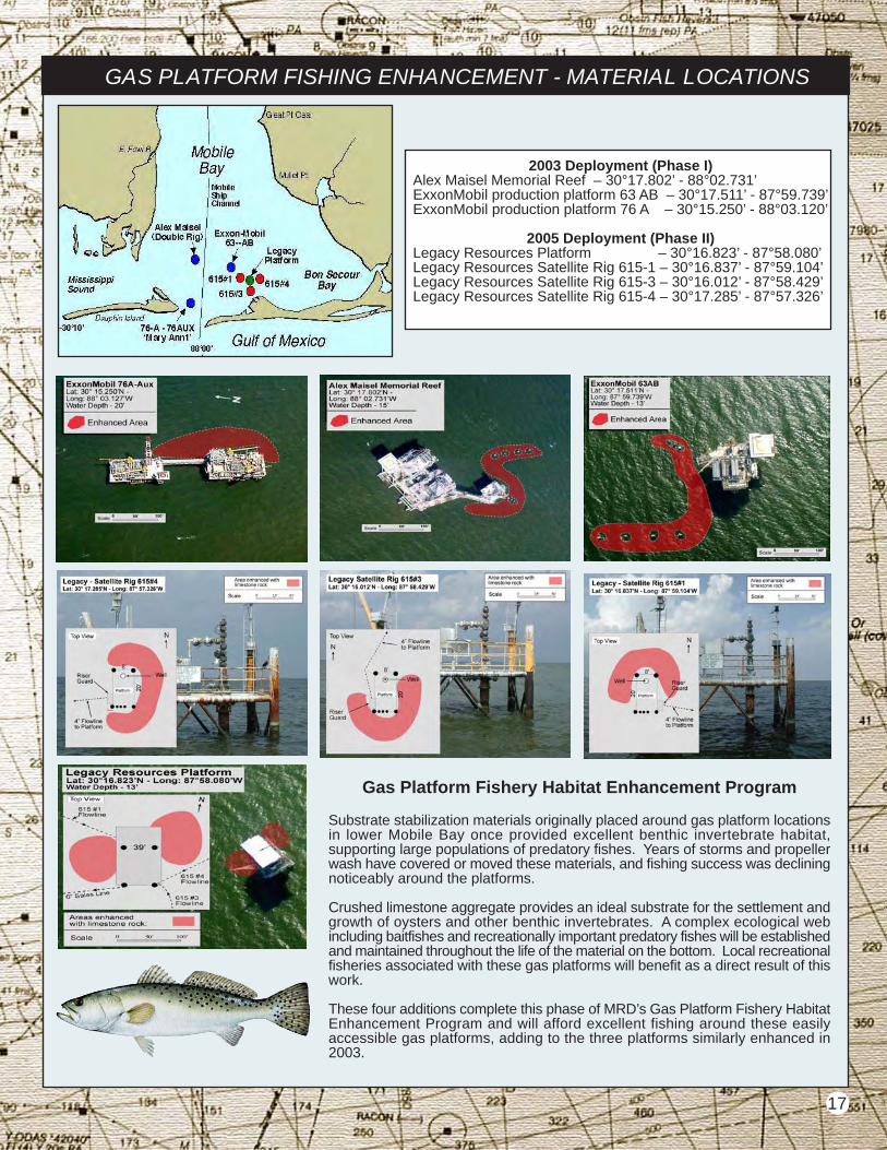
GAS PLATFORM FISHING ENHANCEMENT - MATERIAL LOCATIONS
Gas Platform Fishery Habitat Enhancement Program
Substrate stabilization materials originally placed around gas platform locationsin lower Mobile Bay once provided excellent benthic invertebrate habitat,supporting large populations of predatory fishes. Years of storms and propellerwash have covered or moved these materials, and fishing success was decliningnoticeably around the platforms.
Crushed limestone aggregate provides an ideal substrate for the settlement andgrowth of oysters and other benthic invertebrates. A complex ecological webincluding baitfishes and recreationally important predatory fishes will be establishedand maintained throughout the life of the material on the bottom. Local recreationalfisheries associated with these gas platforms will benefit as a direct result of thiswork.
These four additions complete this phase of MRD’s Gas Platform Fishery HabitatEnhancement Program and will afford excellent fishing around these easilyaccessible gas platforms, adding to the three platforms similarly enhanced in2003.
2003 Deployment (Phase I)Alex Maisel Memorial Reef – 30°17.802’ - 88°02.731’ExxonMobil production platform 63 AB – 30°17.511’ - 87°59.739’ExxonMobil production platform 76 A – 30°15.250’ - 88°03.120’
2005 Deployment (Phase II)Legacy Resources Platform – 30°16.823’ - 87°58.080’Legacy Resources Satellite Rig 615-1 – 30°16.837’ - 87°59.104’Legacy Resources Satellite Rig 615-3 – 30°16.012’ - 87°58.429’Legacy Resources Satellite Rig 615-4 – 30°17.285’ - 87°57.326’
17
The Department of Conservation and Natural Resources does not discriminate on the basis of race, color, gender, religion, national origin, ageor disability in its hiring or employment practices, nor in admission to, access to, or operations of its programs, services or activities.
This publication is available in alternative formats, upon request.
ACKNOWLEDGMENTSSportfish Restoration Funds administered by the U. S. Fish and Wildlife Service were utilized in the preparation
of this document under grant number F-101.
Photos: Marine Resources Division
Fish Illustrations: © Diane Rome Peebles - www.dianepeebles.com
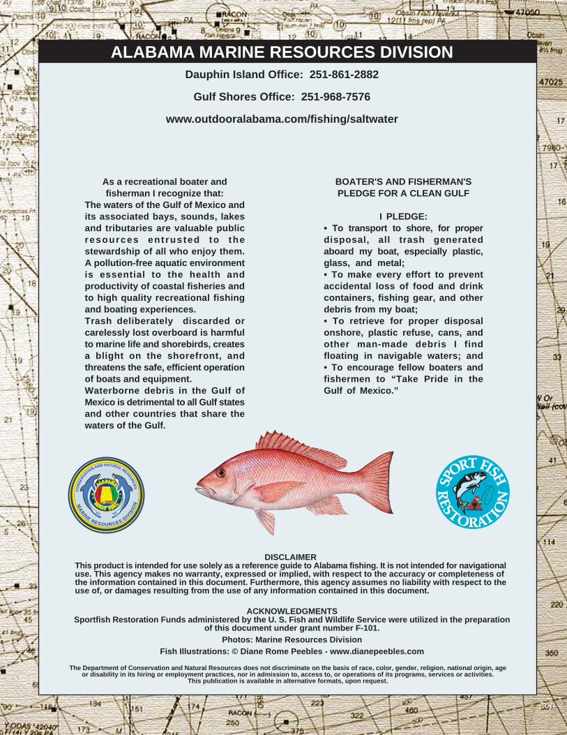
BOATER'S AND FISHERMAN'SPLEDGE FOR A CLEAN GULF
I PLEDGE:• To transport to shore, for properdisposal, all trash generatedaboard my boat, especially plastic,glass, and metal;• To make every effort to preventaccidental loss of food and drinkcontainers, fishing gear, and otherdebris from my boat;• To retrieve for proper disposalonshore, plastic refuse, cans, andother man-made debris I findfloating in navigable waters; and• To encourage fellow boaters andfishermen to “Take Pride in theGulf of Mexico.”
DISCLAIMERThis product is intended for use solely as a reference guide to Alabama fishing. It is not intended for navigationaluse. This agency makes no warranty, expressed or implied, with respect to the accuracy or completeness ofthe information contained in this document. Furthermore, this agency assumes no liability with respect to theuse of, or damages resulting from the use of any information contained in this document.
As a recreational boater andfisherman I recognize that:
The waters of the Gulf of Mexico andits associated bays, sounds, lakesand tributaries are valuable publicresources ent rusted to thestewardship of all who enjoy them.A pollution-free aquatic environmentis essential to the health andproductivity of coastal fisheries andto high quality recreational fishingand boating experiences.Trash deliberately discarded orcarelessly lost overboard is harmfulto marine life and shorebirds, createsa blight on the shorefront, andthreatens the safe, efficient operationof boats and equipment.Waterborne debris in the Gulf ofMexico is detrimental to all Gulf statesand other countries that share thewaters of the Gulf.
Dauphin Island Office: 251-861-2882
Gulf Shores Office: 251-968-7576
www.outdooralabama.com/fishing/saltwater
ALABAMA MARINE RESOURCES DIVISIONC
ON
SE
RVATIO
N AND NATURAL RESOU
RC
ES
MA
RINE
RESOURCES DIVIS
ION
RH
![Daily Bulletin - European Bridge Leaguechampionships.eurobridge.org/EOC2017/Bulletins/Bul_11.pdf · Daily Bulletin Tortona (AL) ... { 1NT Dble 2} Pass Pass 4} Dble 4] Pass 5} Pass](https://img.pdfslide.us/doc/110x75/5b8ef78909d3f2a3498bae31/daily-bulletin-european-bridge-daily-bulletin-tortona-al-1nt-dble.jpg)