Embed Size (px)
Citation preview
Alabama State Port Authority
Requisition and Proposal
Project Name Tropical Weather Debris Removal
PROJECT# 10457 TASK# 7
Form ENG-FR-003 R&P Template Last Revised 1/31/12
To: Prospective Bidders Date: May 2, 2018
Please procure the following and deliver to the address below:
Delivery of Proposal: Alabama State Port Authority Location identified below in Notes #1
Delivery of Work: (Areas around Arlington Park, McDuffie Island, and North Garrow’s Bend)
Mobile, AL
Description of Work
This Requisition solicits proposals to perform storm debris removal around Arlington Park, McDuffie
Island, and North Garrows Bend. The project will require all debris to be removed over approximately
8 acres. Work will be in accordance with the requirements stated herein; attached Scope of Work
Specifications; and applicable State of Alabama Laws.
The work consists principally of providing bonds, labor, materials, equipment, insurance, hand labor,
and supervision necessary to remove storm debris from the wetland areas. Hand tools may be used
on site to reduce the size of logs. Debris may be disposed of at an approved landfill or recycling
facility.
The project site is located in the wetland areas around Arlington Park, McDuffie Island, and North
Garrows Bend (see Scope of Work section).
A mandatory Pre-Bid Meeting is scheduled for Thursday, May 24, 2018 at 10:00 AM at the Killian
Room, 250 N. Water Street, Mobile, AL 36602. Following a discussion of the project, bidders will
caravan to three work sites.
All Contractors submitting bids are to carefully examine the site of the proposed work and thoroughly
review the contract requirements prior to submission of a bid proposal. Each Bidder shall satisfy
oneself to the character, quality, and quantities of work to be performed, and to the requirements of
the proposed contract. The submission of a proposal shall be proof that the bidding Contractor has
made such examination and is satisfied with the conditions to be encountered in performing the work
and with the requirements of the proposed Contract. On bids of $50,000 or more, a bidding
contractor must hold a current license from the State Licensing Board for General Contractors,
Montgomery, Alabama.
The work performed under this contract shall not commence until the Contractor has submitted a
Performance Bond, Labor & Material Bond, and acceptable Certificate of Insurance. Performance
Bond shall be in an amount equal to 100% of the contract price; Labor & Material Bond equal to 100%
of the contract price; and Certificate of Insurance shall be as per the attached requirements and
countersigned by a licensed resident agent in the State of Alabama.

Alabama State Port Authority
Requisition and Proposal
Project Name Tropical Weather Debris Removal
PROJECT# 10457 TASK# 7
2 | P a g e
Form ENG-FR-003 R&P Template Last Revised 1/31/12
Description of Work continued
The Contractor will be required to complete the work under the Contract within 120 calendar days after
receipt of a “Notice to Proceed”. The work will have to be scheduled and performed in a manner that
will not interfere with operations of the facility or ongoing construction activities operating in the
immediate and adjacent areas. Work will start not later than 15 calendar days after receipt of Notice to
Proceed. ASPA intent is that work hours will be during normal day light hours. Additional time will be
allotted for delays due to severe weather events.
The Contractor shall comply with all Federal and State laws, local ordinances and regulations, and all
orders and decrees of bodies or tribunals having any jurisdiction or authority, which in any manner
affect those engaged or employed on the work, or which in any way affect the conduct of the work.
The Contractor shall place a competent superintendent on the Project who shall have experience in the
work being performed under the Contract. The assigned superintendent shall have the responsibility for
the day-to-day operations of the work and shall remain on the Project site while the work under the
Contract is being performed.
Time is an essential element in the contract. As the prosecution of the work will inconvenience the
tenant and interfere with business, it is important that the work be pressed vigorously to completion.
Also, the cost to the Alabama State Port Authority of the administration of the contract, supervision,
inspection and engineering will be increased as the time occupied in the work is lengthened. Therefore,
exclusive of Sundays and national holidays, for each day that the work remains incomplete after the
time specified, an amount of $150.00 shall be paid by the contractor to the Alabama State Port
Authority as liquidated damages for the loss sustained by the State because of failure of the contractor
to complete the work within the specified time.
Alabama State Port Authority
Requisition and Proposal
Project Name Tropical Weather Debris Removal
PROJECT# 10457 TASK# 7
3 | P a g e
Form ENG-FR-003 R&P Template Last Revised 1/31/12
IMPORTANT NOTICE TO BIDDERS REGARDING ACCESS TO ASPA RESTRICTED FACILITIES:
Successful bidders requiring access to the Alabama State Port Authority’s Restricted Facilities to fulfill
any obligations set forth in this bid must comply fully with the Authority’s Access Policy found in its
entirety at http://www.asdd.com/portaccess_policy.html. The Port Authority’s Access Policy requires all
persons permanently employed at the port, including ASPA staff, tenants, and their employees,
surveyors, agents, stevedores, longshoremen, chaplains, contract labor and persons requesting
temporary access to the port, including delivery persons, vendors, contractors, and temporary workers
to obtain and display an ASPA issued photo ID badge or visitor badge at all times when accessing or
working on restricted facilities. In order to obtain an ASPA credential, applicants must also obtain a
Transportation Worker Identification Credential (TWIC) and undergo mandatory Security Awareness
Training. Information on the TWIC can be found at http://www.asdd.com/portaccess_twicregs.html.
Information on Security Awareness Training classes and scheduling can be found at
http://www.asdd.com/portacces_securitytraining.html. ALL PROSPECTIVE BIDDERS ARE ENCOURAGED
TO REVIEW THESE POLICIES AND CONSIDER THESE REQUIREMENTS IN PREPARING BID SUBMISSIONS.
IMPORTANT NOTICE TO BIDDERS REGARDING EMPLOYMENT PRACTICES:
Effective October 1, 2011, the Beason-Hammon Alabama Taxpayer and Citizen Protection Act (“the Act”)
requires that any business entity contracting with or providing any grant or incentives to the state,
including the Alabama State Port Authority, certify compliance with the Act. All Bidders must certify
such compliance by executing the enclosed Affidavit and returning it to the Alabama State Port
Authority with your bid package. The Affidavit must be notarized. The following E-Verify website link is
provided for convenience: http://www.dhs.gov/files/programs/gc_1185221678150.shtm.

Alabama State Port Authority
Requisition and Proposal
Project Name Tropical Weather Debris Removal
PROJECT# 10457 TASK# 7
4 | P a g e
Form ENG-FR-003 R&P Template Last Revised 1/31/12
Contractor’s Proposal
The Contractor hereby agrees to perform previously specified work for the prices outlined in the following schedule. At the discretion of ASPA the quantities of debris to be removed may be increased (with Change Order approval) or decreased during project execution. In the event the quantities do change, the unit price shall apply according to scope of work.
Description Est Qty UOM Unit Price Value
1) Debris Collection 8,100 CY $/CY $
2) Debris Disposal 8,100 CY $/CY $
3) Mobilization 1 EACH Lump Sum $
4) Demobilization 1 EACH Lump Sum $
TOTAL BID $
Contractor’s Project Plan Requirement
The contractor should include with the sealed bid proposal a Project Plan detailing how they intend to execute this project. These statements should discuss the nature/size of the work force to be used, the strategy for removing & transporting debris, the planned final destination of the debris, a complete list of equipment to be used, and all other relevant information that might be applicable to the Contractor’s unique approach in carrying out this work. In the event a more efficient means of execution is recognized by the Contractor after the project is underway, the Project Plan may be altered at the discretion of ASPA. The Contractor would need to communicate requests in writing prior to making any changes. These requirements are in place to ensure standards of personnel safety, ensure fewer disruptions to Port activities, and ensure environmentally responsible practices.
NOTES:
1. Sealed bid proposals will be received via courier to the Alabama State Port Authority, 1400 Alabama State Docks Blvd, Suite 200, Administration Building, Mobile, AL 36602 by 1:00 PM on Thursday, June 7, 2018. U.S. Postal Service is unable to deliver to this address. Sealed bid proposals can also be hand delivered to the Killian Room 30 minutes prior to the official bid opening at 2:00 PM on Tuesday, June 7, 2018 at the Alabama State Port Authority in the International Trade Center building, 250 North Water Street, 1st floor—Killian Room, Mobile, AL. No faxed or electronic bids will be accepted.
2. Bid proposals must be submitted in sealed envelopes with the words “Bid Document Enclosed” clearly marked on the outside of the envelope. The sealed enveloped shall also have the bidder’s name, contractor’s license number, project name, and time and date of bid opening shown on the outside.

Alabama State Port Authority
Requisition and Proposal
Project Name Tropical Weather Debris Removal
PROJECT# 10457 TASK# 7
5 | P a g e
Form ENG-FR-003 R&P Template Last Revised 1/31/12
NOTES Continued:
3. A Bid Bond or Certified Check made payable to the Alabama State Port Authority and equal to
five percent (5%) of the amount bid, not to exceed $10,000, must accompany the Bid Proposal.
4. ASPA reserves the right to refuse to issue a proposal form or a contract to a prospective bidder for any of the following reasons:
a) Failure to pay, or satisfactorily settle, all bills due for labor and materials on former contract in force with the Port Authority.
b) Contractor default under previous Contract with the Authority. c) Proposal withdrawal or Bid Bond forfeiture on previous project with the Authority. d) Unsatisfactory work on previous contract with the Authority. e) Lack of competency and adequate machinery, personnel, plant and other equipment
for performing the project.
5. ASPA may make such investigations as deemed necessary to determine the ability of the bidder to perform the work, and the bidder shall furnish all such information and data for this purpose as ASPA requests. ASPA reserves the right to reject any bid if the evidence submitted by, or investigation of, such bidder fails to satisfy the Authority that such bidder is properly qualified to carry out the obligations of the Contract.
6. Any questions regarding the procurement should be directed to Matt Boehm, Project Manager, at phone number (251) 441-7502. Questions must be submitted by Wednesday, May 30th at 3:00 PM. ASPA will provide responses by Monday, June 4th at 5:00 PM.
7. The right is reserved, as the interest of the Alabama State Port Authority may require, to reject any and all bids and to waive informalities in bids received.


Alabama State Port Authority
Requisition and Proposal
Project Name Tropical Weather Debris Removal
PROJECT# 10457 TASK# 7
7 | P a g e
Form ENG-FR-003 R&P Template Last Revised 1/31/12
AFFIDAVIT AND CERTIFICATE OF COMPLIANCE
FORM FOR SECTIONS 9 (a) and (b) BEASON-HAMMON ALABAMA TAXPAYER AND CITIZEN PROTECTION
ACT; CODE OF ALABAMA, SECTIONS 31-13-9 (a) and (b)
AFFIDAVIT FOR BUSINESS ENTITY/EMPLOYER /CONTRACTOR (To be completed as a condition for the award of any contract, grant, or incentive by the State of Alabama, any political subdivision thereof, or any state-funded entity to a business entity or employer that employs one or more employees)
State of _________________________________________
County of _________________________________________
Before me, a notary public, personally appeared ________________________________ (print name)
who, being duly sworn, says as follows:
As a condition for the award of any contract, grant, or incentive by the State of Alabama, any political
subdivision thereof, or any state-funded entity to a business entity or employer that employs one or
more employees, I hereby attest that in my capacity as ___________________________________(state
position) for _____________________________________________ ___________ (state business
entity/employer/contractor name) that said business entity/employer/contractor shall not knowingly
employ, hire for employment, or continue to employ an unauthorized alien.
I further attest that said business entity/employer/contractor is enrolled in the E-Verify program.
(ATTACH DOCUMENTATION ESTABLISHING THAT BUSINESS ENTITY/EMPLOYER/CONTRACTOR IS
ENROLLED IN THE E-VERIFY PROGRAM)
___________________________________________Signature of Affiant
Sworn to and subscribed before me this _____day of _________________________, 2____.
I certify that the affiant is known (or made known) to me to be the identical party he or she claims to be.
_________________________________________Signature and Seal of Notary Public

Alabama State Port Authority
Requisition and Proposal
Project Name Tropical Weather Debris Removal
PROJECT# 10457 TASK# 7
8 | P a g e
Form ENG-FR-003 R&P Template Last Revised 1/31/12
BID BOND
KNOW ALL MEN BY THESE PRESENTS, that we, undersigned, ______________________
________________________ as Principal, and _______________________________________ as Surety, are hereby held and bound unto The Alabama State Port Authority as OWNER in the Penal sum of _______________________________ for the payment of which will and truly be made, we hereby jointly and severally bind ourselves, successors and assigns. Signed, the ______ day of ___________________, 20___.
The Condition of the above obligation is such that whereas the Principal has submitted to the Alabama State Port Authority a certain BID, attached hereto and hereby made a part hereof to enter into a contract in writing, for the Soil Removal – Baker Street and Bay Avenue in Mobile, Alabama, Project No. 10489, Task No. 1 .
NOW, THEREFORE,
(a) If said BID shall be rejected, or
(b) If said BID shall be accepted and the Principal shall execute and deliver a contract in the form of Contract attached hereto (Properly completed in accordance with said BID) and shall furnish a BOND for his faithful performance of said contract, and for the payment of all persons performing labor or furnishing materials in connection therewith, and shall in all other respects perform the agreement created by the acceptance of said BID, then this obligation shall be void, otherwise the same shall remain in force and effect; it being expressly understood and agreed that the liability of the Surety for any and all claims hereunder shall, in no event, exceed the panel amount of this obligation as herein stated.
The Surety, for value received, hereby stipulates and agrees that the obligations of said Surety and its BOND shall in no way be impaired or affected by any extension of time within which the OWNER may accept such BID; and said Surety does hereby waive notice of any such extension.
IN WITNESS WHEREOF, the Principal and the Surety have hereunto set their hands and seals, and such of them as are corporations have caused their corporate seals to be hereto affixed and these presents to be signed by their proper officers, the day and year first set forth above.
Principal Surety By

APPENDIX A
SCOPE OF WORK AND SPECIFICATIONS

SCOPE OF WORK AND SPECIFICATIONS
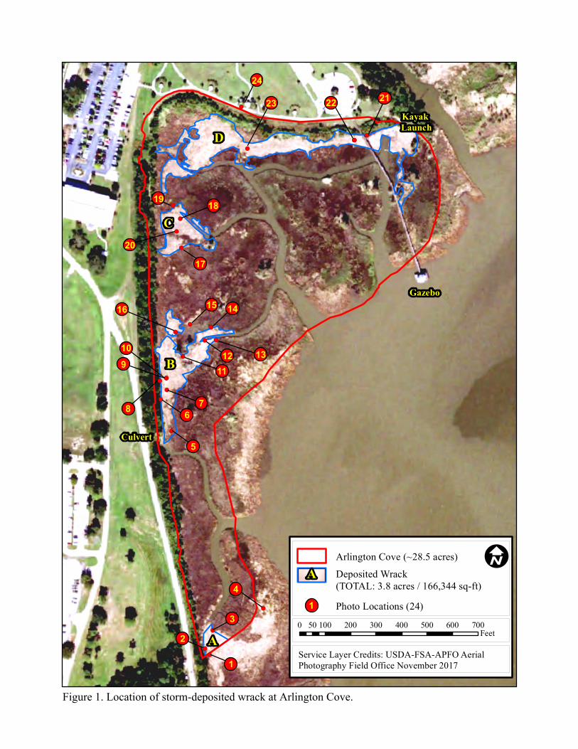
Description of Work: The Contractor shall remove and dispose of storm wrack (woody debris)
in the wetland areas of Arlington Park, North Garrows Bend, and McDuffie as outlined in
Appendix B Figures 1 - 4. Photographs, coordinates, and descriptions of areas of wrack are also
provided in Appendix B. For this scope of work, removal of debris will be focused on natural
woody debris, vegetated debris, and garbage litter (plastics, cans, foil, Styrofoam).
Materials to be furnished by contractor: The contractor shall be responsible for supplying all
materials required for collection of debris, containers, work gloves and required safety
equipment.
Access to the Site: Appendix A Figure 1 is an overview map of the three (3) wetland areas
included in the Scope of Work. The Contractor may access the designated wetland areas by
water or land. ASPA has designated two (2) ASPA property locations which may be used as
staging areas and/or loading/unloading areas as shown in Appendix A Figures 2 and 3 below.
Barge parking, stockpile area, and crew member vehicle parking are available at the location
depicted in Figure 2.
Please note that the access to North Garrows Bend near the railroad bridge, as shown on
Figure 3, will be limited to intervals when the railroad bridge is not in operation. Should the
Contractor desire to utilize this access point, a written request must be submitted to the ASPA
Project Manager and approval received for each day of use.
The selected land access areas shown in ASPA Figures 1-3 are not ASPA restricted facilities.
Bidding contractors may propose for consideration other access areas prior to the bid opening.
For entry to secured facilities such as McDuffie Coal Terminal, all workers must have 1) TWIC,
2) ASPA badge, and 3) ASPA vehicle decal.
Equipment and Tools: The Contractor is required to provide all equipment and tools
necessary to complete work through transporting & delivering debris to its final destination. The
equipment shall be designed and constructed in such a way as to prevent spillage of the
accumulated debris during transport. Also, in keeping with ASPA’s expectations of
environmentally responsible practices equipment should be considered for its ability to execute
tasks without disturbing the sensitive structure of the wetland. Project Plans should be designed
so as to not disturb or otherwise damage the wetlands (e.g. large ruts, evidence of tilling,
removing living vegetation).
Collection and Disposal: Debris shall be collected and handled in a way to track the volume
of material removed from the wetland regardless of its final destination. Disposal tickets or
manifest shall be submitted with contractor’s invoice to verify proper disposal and
document quantities disposed.
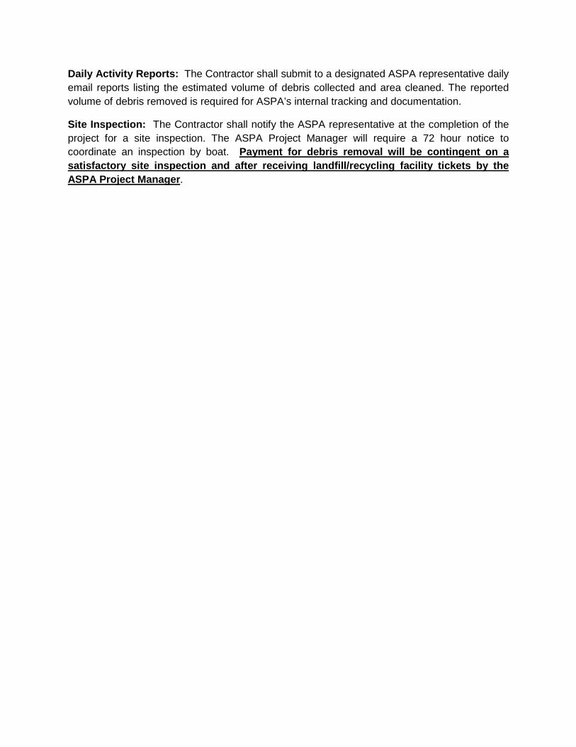
Daily Activity Reports: The Contractor shall submit to a designated ASPA representative daily
email reports listing the estimated volume of debris collected and area cleaned. The reported
volume of debris removed is required for ASPA’s internal tracking and documentation.
Site Inspection: The Contractor shall notify the ASPA representative at the completion of the
project for a site inspection. The ASPA Project Manager will require a 72 hour notice to
coordinate an inspection by boat. Payment for debris removal will be contingent on a
satisfactory site inspection and after receiving landfill/recycling facility tickets by the
ASPA Project Manager.
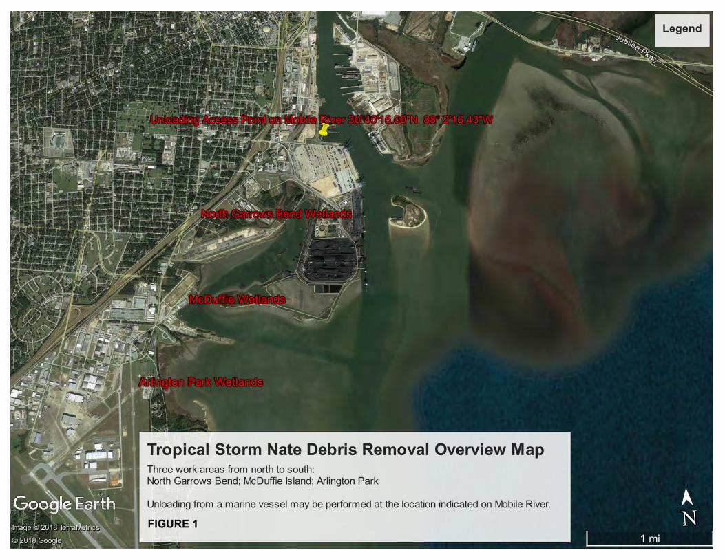
Tropical Storm Nate Debris Removal Overview Map Three work areas from north to south: North Garrows Bend; McDuffie Island; Arlington Park
Unloading from a marine vessel may be performed at the location indicated on Mobile River.
Legend
1 mi
N
➤➤
NImage © 2018 TerraMetrics
Image © 2018 TerraMetrics
Image © 2018 TerraMetrics
© 2018 Google
© 2018 Google
© 2018 Google
FIGURE 1
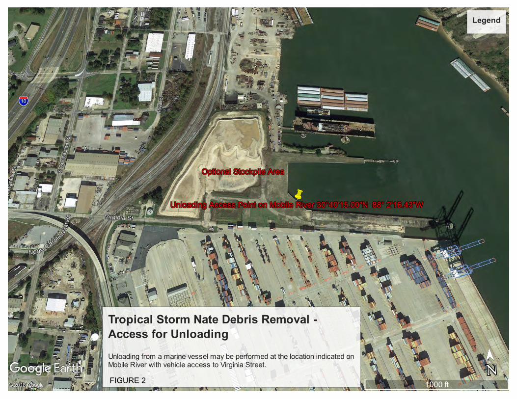
Tropical Storm Nate Debris Removal -Access for Unloading
Unloading from a marine vessel may be performed at the location indicated onMobile River with vehicle access to Virginia Street.
Legend
1000 ft
N
➤➤
N© 2018 Google
© 2018 Google
© 2018 GoogleFIGURE 2

Tropical Storm Nate Debris Removal - Optional Access for North Garrows Bend ***Optional Access from Yeend Street will be provided intermittently with Contractor's request. Due to the proximity of the RR bridge, the Contractor will be required to obtain approval from the ASPA Project Manager prior to each use of this access point. Contractor access will NOT be available during RR bridge operation. The hours of RR bridge operation are irregular so Contractor must be flexible.
Access is intended for pedestrians, wheel barrows, etc. No vehicles will be allowed.
Legend
600 ft
N
➤➤
N© 2018 Google
© 2018 Google
© 2018 Google
FIGURE 3
APPENDIX B
PRELIMINARY DEBRIS FIELD ASSESSMENT

Table 1. Summary of debris field assessment
SITE AREA SQ FEET ACREAGE EST. VOL. Arlington Cove A 5,995 0.14 220
Arlington Cove B 44,278 1.02 1,640 Arlington Cove C 23,692 0.54 850 Arlington Cove D 92,379 2.12 2,400 McDuffie Island A 2,671 0.06 50 McDuffie Island B 655 0.02 20 McDuffie Island C 677 0.02 30 McDuffie Island D 24,649 0.57 460 McDuffie Island E 2,367 0.05 50 North Garrows Bend A 18,680 0.40 650 North Garrows Bend B 8,332 0.19 180 North Garrows Bend C 22,125 0.51 350 North Garrows Bend D 19,856 0.46 200 North Garrows Bend E 5,472 0.13 100 North Garrows Bend F 3,253 0.07 40 North Garrows Bend G 1,575 0.04 30 North Garrows Bend H 28,920 0.66 350 North Garrows Bend I 23,407 0.54 480 TOTAL 328,983 7.54 8,100
!(
!(
!(!(
!(
!(
!(!(
!(!(
!(
!(
!(
!(
!(
!(!(
!(
!(
!(!(!(
!(
!(
!(
Arlington Cove (~28.5 acres)Deposited Wrack(TOTAL: 3.8 acres / 166,344 sq-ft)
Service Layer Credits: USDA-FSA-APFO AerialPhotography Field Office November 2017
1 Photo Locations (24)0 100 200 300 400 500 600 70050
Feet
Culvert
2
1
3
4
5
678
109 11
12 13
141516
17
1819
20
21
Gazebo
Kayak Launch
2223
24
A
B
C
D
A I
Figure 1. Location of storm-deposited wrack at Arlington Cove.

59
8
9
9 979
8
8
9 0 678
84 5
9
17
141010
14
14
1110
10 1010 13
1210
9.56.5
7.5
6.5
edge edge
USDA-FSA-APFO Aerial Photography Field Office, Source: Esri, DigitalGlobe, GeoEye, EarthstarGeographics, CNES/Airbus DS, USDA, USGS, AEX, Getmapping, Aerogrid, IGN, IGP, swisstopo, andthe GIS User Community
Figure 2. Depth of debris (inches) measured along the northern portion of Arlington Cove, March 7, 2018.

!(
!(
!( !(
!(
!(
!(
!(
McDuffie Island (~14.2 acres)
I
Figure 3. Location of storm-deposited wrack at McDuffie Island.
0 100 200 300 400 50050Feet
Deposited Wrack(0.7 acre / 31,019 sq-ft)
Service Layer Credits: USDA-FSA-APFO AerialPhotography Field Office November 2017
1 23 4
5
6 7
8
1 Photo Locations (8)
Barge
AB
CD
E

!(
!(
!(!(!(
!(
!(
!(
!(!(
!(!(
!(
!(!(
!(
!(!(
North Garrows Bend (~19.1 acres)
Figure 4. Location of storm-deposited wrack at North Garrows Bend.
Deposited Wrack(TOTAL: 3.0 acres / 131,619 sq-ft)
Service Layer Credits: USDA-FSA-APFO AerialPhotography Field Office November 2017
1 Photo Locations (18)0 100 200 300 400 500 600 70050
Feet
Culvert
A I
2
34
A
67
8
10
9
B
1
5
11
12
14
15
C
D
E
H
I
F
G
1613
1817

Photo 4. Arlington Cove. View of litter and
dead vegetation from outside the mitigation site
near its southern boundary. 30.641638°N.
88.060934°W. (March 7, 2018)
Photo 3. Arlington Cove. View looking
southwest near the southern boundary. Extent of
clearing with wrack extends outside the
mitigation site 30.641397°N. 88.061567°W.
(March 7, 2018)
Photo 1. Arlington Cove. View looking
northeast from southern boundary showing piles
of logs and dead vegetation. 30.641136 N.
88.061604 W. (March 7, 2018)
Photo 2. Arlington Cove. Depth of dead
vegetation is approximately 13 inches at the
southern boundary of the mitigation site.
30.641200 N. 88.061660 W. (March 7, 2018)
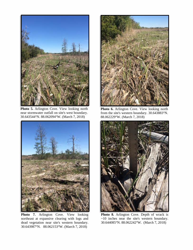
Photo 5. Arlington Cove. View looking north
near stormwater outfall on site's west boundary.
30.643544°N. 88.062094°W. (March 7, 2018)
Photo 6. Arlington Cove. View looking north
from the site's western boundary. 30.643883°N.
88.062229°W. (March 7, 2018)
Photo 7. Arlington Cove. View looking
northeast at expansive clearing with logs and
dead vegetation near site's western boundary.
30.643987°N. 88.062153°W. (March 7, 2018)
Photo 8. Arlington Cove. Depth of wrack is
~10 inches near the site's western boundary.
30.644085°N. 88.062242°W. (March 7, 2018)
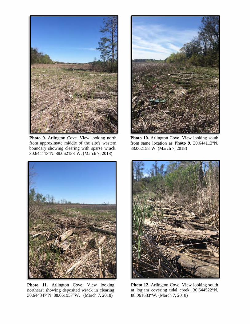
Photo 12. Arlington Cove. View looking south
at logjam covering tidal creek. 30.644522°N.
88.061683°W. (March 7, 2018)
Photo 11. Arlington Cove. View looking
northeast showing deposited wrack in clearing
30.644347°N. 88.061957°W. (March 7, 2018)
Photo 9. Arlington Cove. View looking north
from approximate middle of the site's western
boundary showing clearing with sparse wrack.
30.644113 N. 88.062158 W. (March 7, 2018)
Photo 10. Arlington Cove. View looking south
from same location as Photo 9. 30.644113 N.
88.062158 W. (March 7, 2018)

Photo 13. Arlington Cove. View looking east
along tidal creek showing dead vegetation.
30.644527°N. 88.061542°W. (March 7, 2018)
Photo 14. Arlington Cove. View looking
southwest showing sparse wrack. 30.644663°N.
88.061605°W. (March 7, 2018)
Photo 15. Arlington Cove. View showing dense
cover of dead vegetation only (no course woody
debris present) 30.644695°N. 88.061868°W.
(March 7, 2018)
Photo 16. Arlington Cove. View looking
northeast showing scattered woody debris.
30.644612°N. 88.062047°W. (March 7, 2018)

Photo 17. Arlington Cove. View looking
northwest showing woody debris and dead
vegetation. 30.64552°N. 88.061979°W. (March
7, 2018)
Photo 18. Arlington Cove. View looking
southeast wrack along margin of tidal creek.
Note park pier and gazebo in background.
30.645832°N. 88.061995°W. (March 7, 2018)
Photo 19. Arlington Cove. View looking north
showing sparse cover of wrack 30.645975°N.
88.062087°W. (March 7, 2018)
Photo 20. Arlington Cove. View looking
northeast dead vegetation and scattered woody
debris. 30.645696°N. -88.062041°W. (March
7, 2018)

Photo 23. Arlington Cove. View looking
northeast from base of pier showing leftover
landscaping debris from clearing of parking lot
slope. 30.64669 N. 88.059831 W. (February
21, 2018)
Photo 21. Arlington Cove. View looking east
towards kayak launch showing storm debris
30.646743 N. 88.059674 W. (February 21,
2018)
Photo 22. Arlington Cove. View looking west
from base of park pier bordering parking lot
edge. 30.64669 N. 88.059831 W. (February 21,
2018)
Photo 24. Arlington Cove. View looking
southwest across mitigation site from walking
path. 30.647043 N. 88.061242 W. (February
21, 2018)

Photo 4. McDuffie Island. View from northern
end of interior wrackline looking southeast
across island. (February 27, 2018)
Photo 3. McDuffie Island. View showing large
logs and lumber along east side of site's tidal
creek entrance (February 27, 2018)
Photo 1. McDuffie Island. View looking south
at deposited wrack along the island's north
shoreline approximately 100 feet west of the
site's tidal creek (February 27, 2018)
Photo 2. McDuffie Island. View of site's single
tidal creek entrance looking northeast from its
west side (February 27, 2018)

Photo 5. McDuffie Island. View looking
southeast showing extent of wrack from interior
of the island (February 27, 2018)
Photo 6. McDuffie Island. View looking
southeast near southern extent of wrack
(February 27, 2018)
Photo 7. McDuffie Island. View from island's
interior looking northwest. Note barge in
background for reference (February 27, 2018)
Photo 8. McDuffie Island. View from island's
interior looking northwest showing dense
accumulation of wrack (February 27, 2018)

Photo 4. North Garrows Bend. View showing blocked
culverts at diked railroad berm. 30.664031°N. 88.040469°W.
(February 27, 2018)
Photo 3. North Garrows Bend. View looking
northeast near blocked culvert at diked railroad
berm. 30.664031°N. 88.040469°W. (February
27, 2018)
Photo 1. North Garrows Bend. View looking
north towards diked railroad along west
shoreline of site. 30.663519 N. 88.040642°W.
(February 27, 2018)
Photo 2. North Garrows Bend. View looking
northeast along west shoreline boundary.
30.663729 N. 88.040633 W. (February 27,
2018)
Culvert
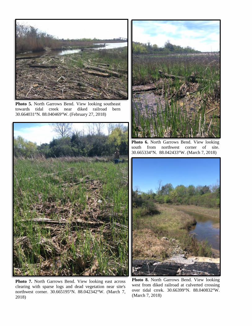
Photo 5. North Garrows Bend. View looking southeast
towards tidal creek near diked railroad bern
30.664031°N. 88.040469°W. (February 27, 2018)
Photo 6. North Garrows Bend. View looking
south from northwest corner of site.
30.665334°N. 88.042433°W. (March 7, 2018)
Photo 7. North Garrows Bend. View looking east across
clearing with sparse logs and dead vegetation near site's
northwest corner. 30.665195°N. 88.042342°W. (March 7,
2018)
Photo 8. North Garrows Bend. View looking
west from diked railroad at culverted crossing
over tidal crrek. 30.66399°N. 88.040832°W.
(March 7, 2018)

Photo 12. North Garrows Bend. View looking
northwest from diked railroad bridge. Same
location as Photo 11. 30.662704°N.
88.041962°W. (March 7, 2018)
Photo 11. North Garrows Bend. View looking
southwest paralleling diked railroad showing
deposited trash and wrack. 30.662704°N.
88.041962°W. (March 7, 2018)
Photo 9. North Garrows Bend. Storm-deposited
trash and wrack at base of bridged railroad
crossing 30.663081 N. 88.041633 W. (March
7, 2018)
Photo 10. North Garrows Bend. View looking
northwest from same location as Photo 9.
30.663081 N. 88.041633 W. (March 7, 2018)

Photo 13. North Garrows Bend. View looking
north from railroad showing deposited trash.
30.662415°N. 88.042192°W. (March 7, 2018)
Photo 14. North Garrows Bend. View looking
northwest from railroad bridge showing area
depicting an aerial signature of debris, but
lacking obvious wrack in the field.
30.662007°N. 88.042533°W. (March 7, 2018)
Photo 15. North Garrows Bend. View looking
northwest along east side of railroad bridge
showing sparse logs along shoreline edge.
Same location as Photo 14. 30.662007°N.
88.042533°W. (March 7, 2018)
Photo 16. North Garrows Bend. View looking
southeast showing blocked tidal creek entrance
on east shoreline 30.662535°N. 88.042001°W.
(March 7, 2018)
Blocked Tidal Creek Inlet

Photo 18. North Garrows Bend. View looking
southeast from upland parking area at northern
boundary of site showing large amount of
deposited debris accumulated at head of bay.
Same location as Photo 18. 30.663726°N.
88.039838°W. (February 21, 2018)
Photo 17. North Garrows Bend. View looking
southwest from upland parking area at northern
boundary of site showing large amount of rafted
debris accumulated at head of bay.
30.663726°N. 88.039838°W. (February 21,
2018)