Embed Size (px)
Citation preview

Al Lubban ash Sharqiya Village Profile (including ‘Ammuriya Locality)
Prepared by
The Applied Research Institute – Jerusalem
Funded by
Spanish Cooperation
2014
Palestinian Localities Study Nablus Governorate
1
Acknowledgments
ARIJ hereby expresses its deep gratitude to the Spanish Agency for International Cooperation for
Development (AECID) for their funding of this project.
ARIJ is grateful to the Palestinian officials in the ministries, municipalities, joint services councils,
village committees and councils, and the Palestinian Central Bureau of Statistics (PCBS) for their
assistance and cooperation with the project team members during the data collection process.
ARIJ also thanks all the staff who worked throughout the past couple of years towards the
accomplishment of this work.

Palestinian Localities Study Nablus Governorate
2
Background
This report is part of a series of booklets which contain compiled information about each city, town,
and village in the Nablus Governorate. These booklets came about as a result of a comprehensive
study of all localities in the Nablus Governorate, and aim to depict the overall living conditions in the
governorate and present developmental plans to assist in improving the livelihood of the population
in the area. It was accomplished through the "Village Profiles and Needs Assessment" project funded
by the Spanish Agency for International Cooperation for Development (AECID).
The "Village Profiles and Needs Assessment" was designed to study, investigate, analyze and
document the socio-economic conditions and the programs and activities needed to mitigate the
impact of the current insecure political, economic and social conditions in the Nablus Governorate.
The project's objectives are to survey, analyze and document the available natural, human,
socioeconomic and environmental resources, and the existing limitations and needs assessment for
the development of the rural and marginalized areas in the Nablus Governorate. In addition, the
project aims to prepare strategic developmental programs and activities to mitigate the impact of the
current political, social, and economic instability with a focus on the agricultural sector.
All locality profiles in Arabic and English are available online at http://vprofile.arij.org.
Palestinian Localities Study Nablus Governorate
3
Table of Contents
Location and Physical Characteristics ____________________________________ 4
Religious and Archaeological Sites ______________________________________ 6
Population __________________________________________________________ 8
Education __________________________________________________________ 8
Health Status ________________________________________________________ 9
Economic Activities __________________________________________________ 10
Agricultural Sector __________________________________________________ 11
Institutions and Services ______________________________________________ 14
Infrastructure and Natural Resources ___________________________________ 14
Geopolitical Status in Al Lubban ash Sharqiya village ______________________ 16
Development Plans and Projects _______________________________________ 19
Implemented Projects ________________________________________________ 19
Proposed Projects ___________________________________________________ 20
Locality Development Priorities and Needs _______________________________ 21
References: ________________________________________________________ 22
Palestinian Localities Study Nablus Governorate
4
Al Lubban ash Sharqiya Village Profile
(including ‘Ammuriya Locality)1
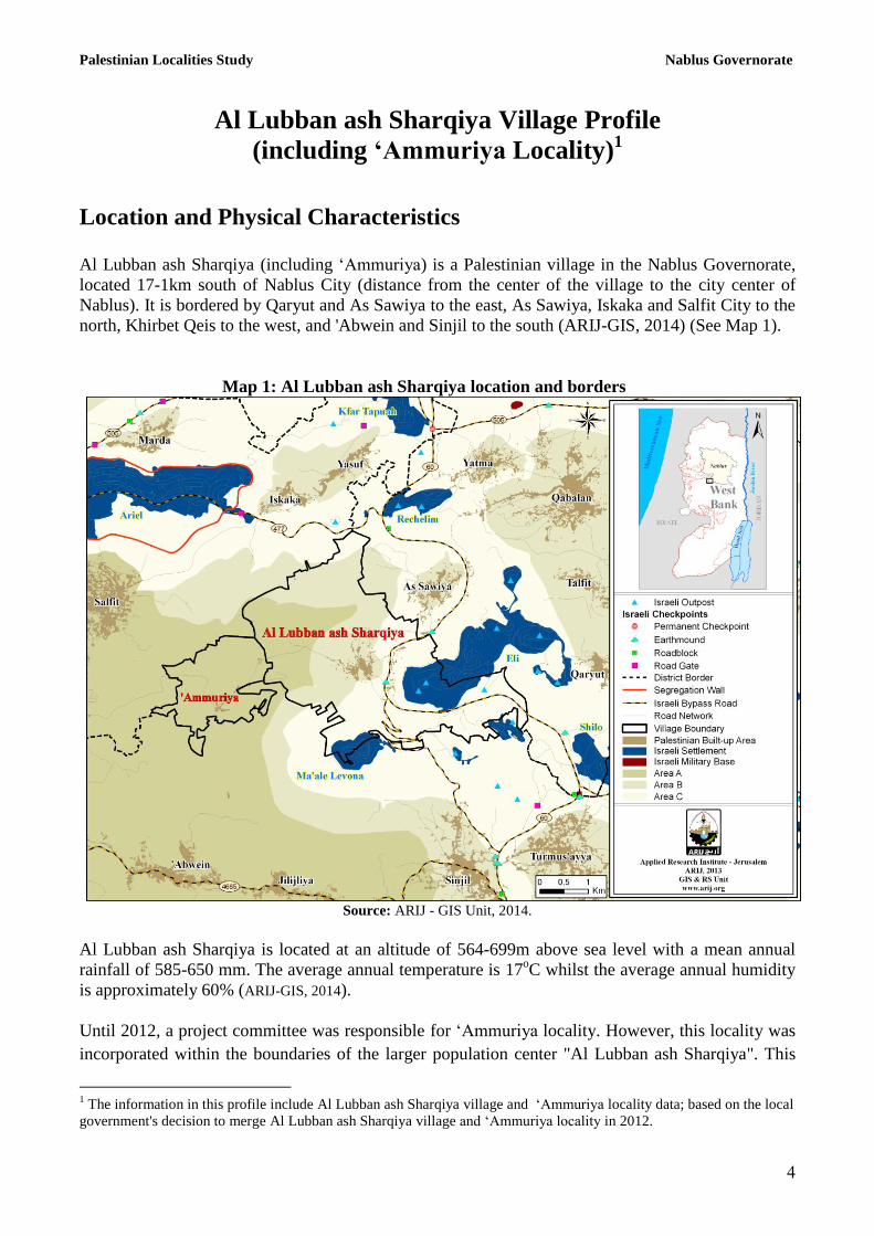
Location and Physical Characteristics
Al Lubban ash Sharqiya (including ‘Ammuriya) is a Palestinian village in the Nablus Governorate,
located 17-1km south of Nablus City (distance from the center of the village to the city center of
Nablus). It is bordered by Qaryut and As Sawiya to the east, As Sawiya, Iskaka and Salfit City to the
north, Khirbet Qeis to the west, and 'Abwein and Sinjil to the south (ARIJ-GIS, 2014) (See Map 1).
Map 1: Al Lubban ash Sharqiya location and borders
Source: ARIJ - GIS Unit, 2014.
Al Lubban ash Sharqiya is located at an altitude of 564-699m above sea level with a mean annual
rainfall of 585-650 mm. The average annual temperature is 17oC whilst the average annual humidity
is approximately 60% (ARIJ-GIS, 2014).
Until 2012, a project committee was responsible for ‘Ammuriya locality. However, this locality was
incorporated within the boundaries of the larger population center "Al Lubban ash Sharqiya". This
1 The information in this profile include Al Lubban ash Sharqiya village and ‘Ammuriya locality data; based on the local
government's decision to merge Al Lubban ash Sharqiya village and ‘Ammuriya locality in 2012.

Palestinian Localities Study Nablus Governorate
5
was done via a resolution adopted by the Palestinian Cabinet and the Ministry of Local Government
in 2012, and according to this resolution, ‘Ammuriya and Al Lubban ash Sharqiya came under the
administrative authority of one municipal council which is called "Al Lubban ash Sharqiya"
Municipal Council.
The total area of Al Lubban ash Sharqiya village consists of approximately 156,31 dunums. The
borders of this locality are set according to the new local councils’ borders which were defined by
the Palestinian Ministry of Local Government. The new borders of the Palestinian localities were set
by the Palestinian National Authority, represented by the Ministry of Local Government, the Central
Elections Commission, the Ministry of Planning and the Palestinian Central Bureau of Statistics, in
the year 2011. These governmental institutions reset the borders of the localities for the purpose of
the Palestinian elections that took place in 2011. Accordingly, ARIJ adopted these new borders in
this report since it found that the newly adopted borders, to a certain extent, better suit the
demographic, environmental and agricultural variables and facts on the ground. Also, ARIJ uses
these defined borders only for the sake of this research and study. It is worth noting that these
borders do not represent the areas and borders of the private properties at the locality level and are
not included in the PNA files of the private land holdings.
Since 1996, Al Lubban ash Sharqiya has been governed by a Village Council which is currently
administrated by 11 members appointed by the Palestinian National Authority (PNA). There is also 1
employee working for the council, which owns its permanent headquarters. It is located within the
Joint Services Council of Beita. The council does not own a waste collection vehicle (Al Lubban ash
Sharqiya Village Council, 2013).
It is the responsibility of the Village Council to provide a number of services to the residents of Al
Lubban ash Sharqiya, including:
The establishment and maintenance of the drinking water resources
The establishment and maintenance of the electricity network
Street cleaning, solid waste collection, road rehabilitation, construction and paving, and
provision of social services
Protection of government properties
Protection of historical and archaeological sites
Implementation of projects and studies for the village
(Al Lubban ash Sharqiya Village Council, 2013)
Historical Background
The village of Al Lubban ash Sharqiya was named for "Al Lubban" which means easy and broad,
and the word "eastern", due to its location in the east, and to distinguish it from Al Lubban al Gharbi
(Al Lubban ash Sharqiya Village Council 2013). The date of the establishment of the assembly is
ancient. The origins of the inhabitants of the village come from Al Lubban ash Sharqiya, Walaja, and
Yemen (Al Lubban ash Sharqiya Village Council, 2013) (see photo 1).

Palestinian Localities Study Nablus Governorate
,
Photo of Al Lubban ash Sharqiya
Religious and Archaeological Sites
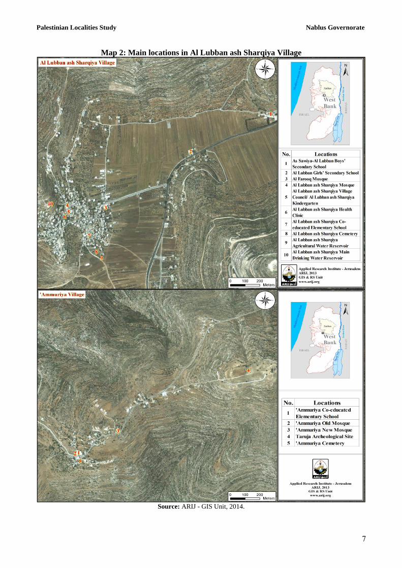
There are three mosques in the village: Al Lubban ash Sharqiya, Al Omari, and Al Farouq Mosques.
There are also a number of archeological sites in the village, including: Al Omari Mosque, the Al
Khan area, and the ancient tomb of As Shaykh (Al Aruri). It is worth mentioning that none of them
are eligible for designation as an official tourism site with the exception of Al-Omari Mosque (Al
Lubban ash Sharqiya Village Council, 2013) (See Map 2).
Palestinian Localities Study Nablus Governorate
1
Map 2: Main locations in Al Lubban ash Sharqiya Village
Source: ARIJ - GIS Unit, 2014.

Palestinian Localities Study Nablus Governorate
8
Population
According to the Palestinian Central Bureau of Statistics (PCBS), the total population of Al Lubban
ash Sharqiya in 2007 was 26125, of whom 16313 were male and 16352 female. There were 458
households registered as living in 511 housing units.
Age Groups and Gender
The General Census of Population and Housing carried out by PCBS in 2007 showed the distribution
of age groups in Al Lubban ash Sharqiya as follows: 4442% were less than 15 years of age, 51%
were between 15 and 64 years of age, and 443% were 65 years of age or older. Data also showed that
the sex ratio of males to females in the village is 100: 1.14, , meaning that males and females
constitute 5.44% and 4.4,% of the population, respectively.
Families
Al Lubban ash Sharqiya residents originate from several families, including: Tilan, Abu Khader,
Salman, Al Seid, Deeb, Hijaz, Samara, Ahmed Ali, Al Nawaserah, Hamad, Nubani, Al Hakawati,
Rabie’, Nassar, Ahmed Abdel-Jalil, Al Mokhader, and Abed families. (Al Lubban ash Sharqiya Village
Council, 2013).
Immigration
The field survey conducted by ARIJ staff shows that approximately 15 people have left the village
since the Al Aqsa Intifada in 2000 (Al Lubban ash Sharqiya Village Council, 2013).
Education
According to the results of the PCBS Population, Housing and Establishment Census-2007, the
illiteracy rate among Al Lubban ash Sharqiya population is approximately 8%, of which 8.41% are
females. Of the literate population, 1444% could only read and write, with no formal education,
2141% had elementary education, 2.4,% had preparatory education, 1343% had secondary education,
and ,4.% completed higher education. Table 1 shows the educational level in the village of Al
Lubban ash Sharqiya by sex and educational attainment in 2007.
Table 1: Al Lubban ash Sharqiya population (10 years and above) by sex and educational attainment
S
E
x
Illite-
rate
Can
read &
write
Element-
ary
Preparat-
ory
Second-
ary
Associate
Diploma Bachelor
Higher
Diploma Master
PhD Un-
known Total
M 29 160 278 278 113 21 42 1 6 1 1 930 F 122 113 246 282 138 22 37 0 1 0 0 961 T 151 273 524 560 251 43 79 1 7 1 1 1,891 Source: PCBS, 2009.
There are three public schools in the village run by the Palestinian Ministry of Higher Education (see
Table 2).
Palestinian Localities Study Nablus Governorate
.
Table 2: Schools in Al Lubban ash Sharqiya by name, stage, sex, and supervising authority (2011/2012)
School Name Supervising Authority Sex
Al Lubban ash Sharqiya Co-educated Elementary School Government Mixed
Al Lubban ash Sharqiya Girls Secondary School Government Female
‘Ammuriya Co-educated Elementary School Government Mixed
Source: Directorate of Education in Nablus, 2012
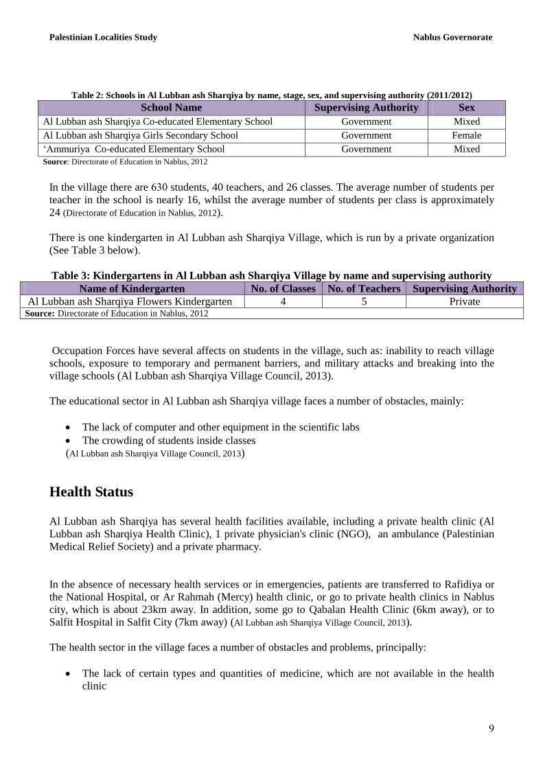
In the village there are ,3. students, 40 teachers, and 26 classes. The average number of students per
teacher in the school is nearly 16, whilst the average number of students per class is approximately
24 (Directorate of Education in Nablus, 2012).
There is one kindergarten in Al Lubban ash Sharqiya Village, which is run by a private organization
(See Table 3 below).
Table 3: Kindergartens in Al Lubban ash Sharqiya Village by name and supervising authority
Name of Kindergarten No. of Classes No. of Teachers Supervising Authority
Al Lubban ash Sharqiya Flowers Kindergarten 4 5 Private Source: Directorate of Education in Nablus, 2012
Occupation Forces have several affects on students in the village, such as: inability to reach village
schools, exposure to temporary and permanent barriers, and military attacks and breaking into the
village schools (Al Lubban ash Sharqiya Village Council, 2013).
The educational sector in Al Lubban ash Sharqiya village faces a number of obstacles, mainly:
The lack of computer and other equipment in the scientific labs
The crowding of students inside classes
(Al Lubban ash Sharqiya Village Council, 2013)
Health Status
Al Lubban ash Sharqiya has several health facilities available, including a private health clinic (Al
Lubban ash Sharqiya Health Clinic), 1 private physician's clinic (NGO), an ambulance (Palestinian
Medical Relief Society) and a private pharmacy.
In the absence of necessary health services or in emergencies, patients are transferred to Rafidiya or
the National Hospital, or Ar Rahmah (Mercy) health clinic, or go to private health clinics in Nablus
city, which is about 23km away. In addition, some go to Qabalan Health Clinic (6km away), or to
Salfit Hospital in Salfit City (7km away) (Al Lubban ash Sharqiya Village Council, 2013).
The health sector in the village faces a number of obstacles and problems, principally:
The lack of certain types and quantities of medicine, which are not available in the health
clinic

Palestinian Localities Study Nablus Governorate
1.
The lack of medical staff in the health clinic
The lack of medical equipment in the health clinic
(Al Lubban ash Sharqiya Village Council, 2013)
Economic Activities
The economy in Al Lubban ash Sharqiya is dependent mainly on the services sector, which absorbs
40% of the village’s workforce (Al Lubban ash Sharqiya Village Council, 2013) (See Figure 1).
The results of a field survey conducted by the ARIJ team in 2013 looking at the distribution of labor
according to economic activity in Al Lubban ash Sharqiya are as follows:
Services sector (40%)
Public employees sector (23%)
Agricultural sector (20%)
Israeli labor market (10%)
Trade sector (6%)
Industry (1%)
Figure 1: The distribution of labour force among main economic activities in Al Lubban ash
Sharqiya
Source: Al Lubban ash Sharqiya Village Council, 2013
Al Lubban ash Sharqiya has 50 markets, 1 bakery, 3 butcher shops, 1 fruits and vegetables store, 4
different professional workshops, 7 industrial shops (blacksmith, carpentry, etc.),3 quarries, 2 stone
cutters, and 1 oil press (Al Lubban ash Sharqiya Village Council, 2013).
Palestinian Localities Study Nablus Governorate
11
In 2013, the unemployment rate in Al Lubban ash Sharqiya reached 2.% and the groups most
affected economically by the Israeli restrictions have been:
Workers in the Agricultural sector
Workers in the Israeli labor market
Workers in the Trade sector
Workers in the Services sector
Workers in the Public employees sector
(Al Lubban ash Sharqiya Village Council, 2013)
Labor Force
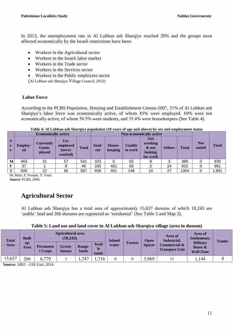
According to the PCBS Population, Housing and Establishment Census-2007, 31% of Al Lubban ash
Sharqiya’s labor force was economically active, of whom 85% were employed. ,.% were not
economically active, of whom 5.45% were students, and 3544% were housekeepers (See Table 4).
Table 4: Al Lubban ash Sharqiya population (10 years of age and above) by sex and employment status
S
e
x
Economically active Non-economically active
Not
stated Total Employ-
ed
Currently
Unem-
ployed
Un-
employed
(never
worked)
Total Stud-
ent
House-
keeping
Unable
to work
Not
working
& not
looking
for work
Others Total
M 463 21 57 541 323 0 55 8 3 389 0 930
F 37 1 8 46 335 461 93 2 24 915 0 961
T 500 22 65 587 658 461 148 10 27 1304 0 1,891 M: Male; F: Female; T: Total.
Source: PCBS, 2009.
Agricultural Sector
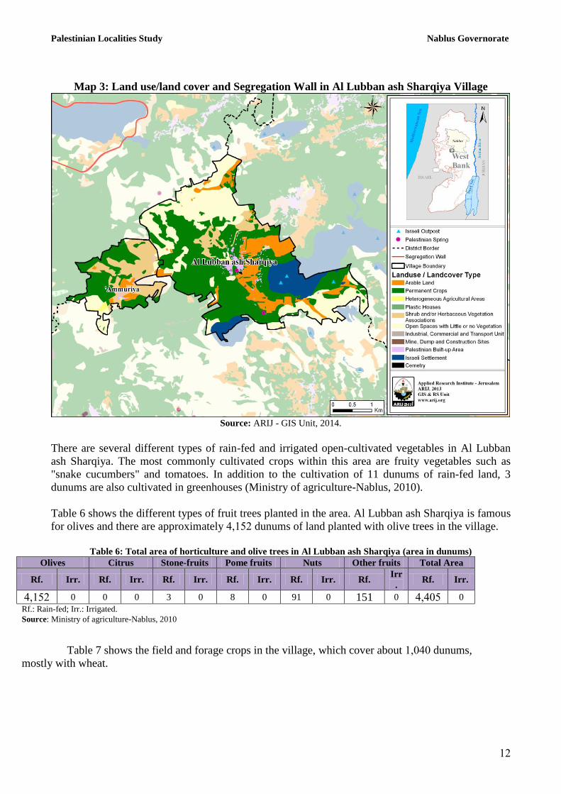
Al Lubban ash Sharqiya has a total area of approximately 15,637 dunums of which 10,243 are
‘arable’ land and 266 dunums are registered as ‘residential’ (See Table 5 and Map 3).
Table 5: Land use and land cover in Al Lubban ash Sharqiya village (area in dunum)
Total
Area
Built
up
Area
Agricultural area
(10,243)
Inland
water
Forests Open
Spaces
Area of
Industrial,
Commercial &
Transport Unit
Area of
Settlements,
Military
Bases &
Wall Zone
Tombs
Permanen
t Crops
Green-
houses
Range-
lands
Arab
le
lands
156,31 2,, ,611. 1 16141 1611, 0 0 36.,. 11 16144 4
Source: ARIJ – GIS Unit, 2014.
Palestinian Localities Study Nablus Governorate
12
Map 3: Land use/land cover and Segregation Wall in Al Lubban ash Sharqiya Village
Source: ARIJ - GIS Unit, 2014.
There are several different types of rain-fed and irrigated open-cultivated vegetables in Al Lubban
ash Sharqiya. The most commonly cultivated crops within this area are fruity vegetables such as
"snake cucumbers" and tomatoes. In addition to the cultivation of 11 dunums of rain-fed land, 3
dunums are also cultivated in greenhouses (Ministry of agriculture-Nablus, 2010).
Table 6 shows the different types of fruit trees planted in the area. Al Lubban ash Sharqiya is famous
for olives and there are approximately 46152 dunums of land planted with olive trees in the village.
Table 6: Total area of horticulture and olive trees in Al Lubban ash Sharqiya (area in dunums)
Olives Citrus Stone-fruits Pome fruits Nuts Other fruits Total Area
Rf. Irr. Rf. Irr. Rf. Irr. Rf. Irr. Rf. Irr. Rf. Irr
. Rf. Irr.
46152 0 0 0 3 0 8 0 91 0 151 0 464.5 0
Rf.: Rain-fed; Irr.: Irrigated.
Source: Ministry of agriculture-Nablus, 2010
Table 7 shows the field and forage crops in the village, which cover about 16.4. dunums,
mostly with wheat.
Palestinian Localities Study Nablus Governorate
13
Table 7: Total area of field and forage crops in Al Lubban ash Sharqiya (area in dunums)
Grain
Bulbs,
Tubers, and
Roots
Dry
Legumes Oily Crops
Forage
Crops
Al Lubban
ash
Sharqiyatale
Crops
Other Crops Total Area
Rf. Irr. Rf. Irr. Rf. Irr. Rf. Rf. Irr. Irr. Rf. Irr
. Rf. Irr. Rf. Irr.
16.4. 0 22 0 160 0 14 0 217 0 0 0 34 0 1,487 0
Rf: Rain-fed; Irr: Irrigated
Source: Ministry of agriculture- Nablus, 2010
The difference in size of agricultural areas between the two sets of results obtained from the Ministry
of Agriculture (MoA) and ARIJ’s GIS Unit is explained by the difference in each organization’s
definition of land coverage and ownership. The MoA and the Palestinian Central Bureau of Statistics
(2011) conducted a survey which used a definition of agricultural areas based on land ownership.
Therefore, the areas included in the survey were those of actual holdings of agricultural areas and did
not consider fragmented and small seasonal cultivated areas in residential and agricultural areas.
ARIJ’s survey, however, indicated the existence of a high proportion of small and fragmented
holdings (home gardens) throughout the occupied Palestinian territories. This therefore, accounts for
the larger area of agricultural holdings calculated by ARIJ.
The field survey conducted by ARIJ team shows that 9% of the residents in Al Lubban ash Sharqiya
rear and keep domestic animals such as cows and sheep and others (See Table 8).
Table 8: Livestock in Al Lubban ash Sharqiya
Cows* Sheep Goats Camels Horses Donkeys Mules Broiler
Chickens
Layer
Chickens
Bee
Hives
13 870 690 0 0 0 0 50,000 1,000 110 *Including cows, bull calves, heifer calves and bulls
Source: Palestinian Ministry of Agriculture - Nablus, 2010
There are approximately 80 kilometers of agricultural roads in the village, categorized as follows:
Table 9: Agricultural Roads in Al Lubban ash Sharqiya Village and their Lengths
Suitability of Agricultural Roads Length (km)
For vehicles 40
For tractors and agricultural machinery only 40
For animals only 0
Unsuitable 0 Source: Al Lubban ash Sharqiya Village Council, 2013
The agricultural sector in the village faces some problems, including:
Rising costs of production inputs
The lack of agricultural extension and insufficient awareness of the farmer
The lack of government support and ignoring of agriculture in Palestine
The lack of economic feasibility
(Al Lubban ash Sharqiya Village Council, 2013)
Palestinian Localities Study Nablus Governorate
14
Institutions and Services
Al Lubban ash Sharqiya village has a number of local institutions and associations that provide
services to various sectors of society. These include:
Al Lubban ash Sharqiya Village Council: Founded in 1996, and later registered by the Ministry of
Local Government, its aim is to bring attention to the issues in the village and to provide all services
to the population; in addition to providing infrastructure services.
Al Lubban ash Sharqiya Sports Club: Established in 1994 and later registered by the Ministry of
Youth and Sports, it was created in order to interest young people, train them, and provide services to
them to improve their athletic skills. (Al Lubban ash Sharqiya Village Council, 2013)
Infrastructure and Natural Resources
Electricity and Telecommunication Services
Al Lubban ash Sharqiya has been connected to a public electricity network since 1994. It is served
by the Israeli Qatariya Electricity Company, which is the main source of electricity in the village,
through the North Electricity Company, 100% of the housing units in the village are connected to the
network. The village residents face a number of problems concerning electricity, primarily the
increase in the pressure on the electricity network (Al Lubban ash Sharqiya Village Council, 2013).
Al Lubban ash Sharqiya is also connected to a telecommunications network and approximately 10%
of the housing units within the village boundaries are connected to phone lines (Al Lubban ash Sharqiya
Village Council, 2013).
Transportation Services:
There are 20 taxis in Al Lubban ash Sharqiya. If there is a lack of transportation, taxis from the main
street (Nablus –Ramallah) will be used (Al Lubban ash Sharqiya Village Council, 2013). There are some
problems facing the citizens such as the presence of military checkpoints.There are 15km of main
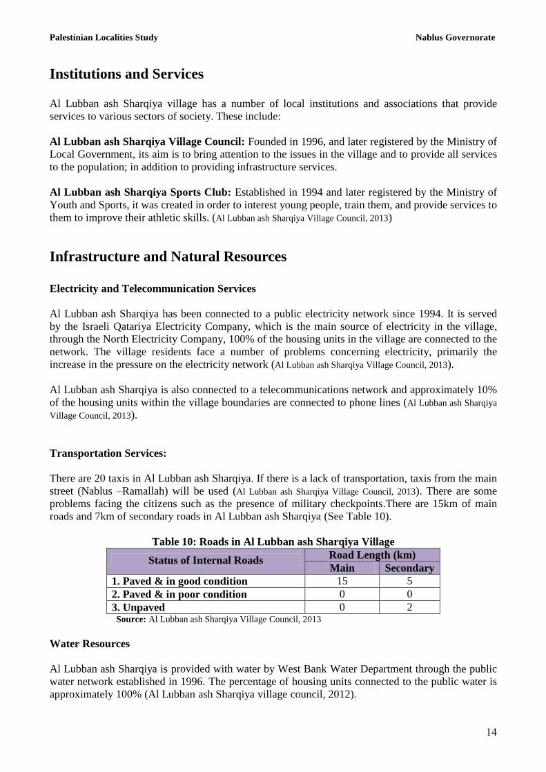
roads and 7km of secondary roads in Al Lubban ash Sharqiya (See Table 10).
Table 10: Roads in Al Lubban ash Sharqiya Village
Status of Internal Roads Road Length (km)
Main Secondary
1. Paved & in good condition 15 5
2. Paved & in poor condition 0 0
3. Unpaved 0 2 Source: Al Lubban ash Sharqiya Village Council, 2013
Water Resources
Al Lubban ash Sharqiya is provided with water by West Bank Water Department through the public
water network established in 1996. The percentage of housing units connected to the public water is
approximately 100% (Al Lubban ash Sharqiya village council, 2012).
Palestinian Localities Study Nablus Governorate
15
The quantity of water supplied to Al Lubban ash Sharqiya village in 2012 was approximately
120,000 cubic meters/year (Al Lubban ash Sharqiya Village Council, 2012). Therefore, the estimated
rate of water supply per capita is approximately 107 liters/day. However, no Al Lubban ash Sharqiya
citizen consumes this amount of water due to water losses, which are estimated at 30% (Al Lubban
ash Sharqiya village Council, 2013). These losses happen at the main source, major transport lines,
in the distribution network, and at the household level. Therefore, the rate of water consumption per
capita in Al Lubban ash Sharqiya is 75 liters per day (Al Lubban ash Sharqiya Village Council,
2013). This rate is low compared to the minimum proposed by the World Health Organization of at
least 100 liters per capita per day.
The village has nine water springs, which are used for livestock, in addition to 50 domestic wells to
collect rain water. The village also has a water tank with a 500 cubic meter capacity (Al Lubban ash
Sharqiya Village Council, 2013). The price of one cubic meter of water from the public network is 4
NIS (Al Lubban ash Sharqiya Village Council, 2013).
Wastewater Status
Al Lubban ash Sharqiya village lacks a public sewerage network and most of the population uses
cesspits and septic tanks as a main means for wastewater disposal (Al Lubban ash Sharqiya village
council, 2013).
Based on the estimated daily per capita water consumption, the approximated quantity of wastewater
generated per day is 184 cubic meters, or 67,000 cubic meters annually. At the individual level, it is
estimated that the per capita wastewater generation is approximately 60 liters per day. The
wastewater collected by cesspits and septic tanks is discharged by wastewater tankers directly into
open areas or nearby valleys with little regard for the environment. Here it is noted that there is no
wastewater treatment either at the source or at the disposal sites and this poses a serious threat to the
environment in addition to public health (ARIJ - WERU, 2013).
Solid Waste Management:
Al Lubban ash Sharqiya village is responsible for managing solid waste collection and disposal of
the waste generated by citizens and establishments in the village. Due to the fact that solid waste
management is costly, a monthly fee of 15 NIS per house per month is charged to the population for
the service of domestic solid waste collection and transportation. The rate of fee collection is 100%
(Al Lubban ash Sharqiya village council, 2013).
Most of the population in Al Lubban ash Sharqiya benefit from the solid waste services, where waste
is collected from households, institutions, shops, and public squares in plastic bags. The Council
collects the solid waste three times a week and transports it through the use of a waste collection
vehicle to the random dumping site for the village, 3km away from the village. Here the waste is
subsequently burned and buried in an unhealthy way (Al Lubban ash Sharqiya village council, 2013).
The daily per capita rate of solid waste production in Al Lubban ash Sharqiya is 0.7kg. Thus the
estimated amount of solid waste produced per day from the Al Lubban ash Sharqiya residents is
nearly 2.1 tons, or 785 tons per year (ARIJ - WERD, 2013).

Palestinian Localities Study Nablus Governorate
1,
Environmental Conditions
The village of Al Lubban ash Sharqiya and other towns in the Nablus Governorate suffer
environmental problems that must be addressed, for instance:
Water Sector
Interruption of water for long periods, especially in the summer
Wastewater Management
The absence of a public sewage network means that the residents are forced to use unhygienic
cesspits and septic tanks for the disposal of wastewater and sometimes dispose of wastewater in the
streets. This is particularly common in winter, as citizens cannot afford the high cost of sewage
tankers during this period. These methods cause environmental damage, health problems and the
spread of epidemics and diseases in the village. The wastewater also contaminates the groundwater
and water collected in household cisterns (rainwater-harvesting cisterns). Most cesspits are built
without lining, allowing wastewater to enter into the ground and avoiding the need to use sewage
tankers. Thus, ground water cannot be used as drinking water. Moreover, the untreated wastewater
collected from cesspits by sewage tankers is disposed of in open areas without concern for the
damage it causes to the environment and to residents' health. (Al Lubban ash Sharqiya village
council, 2013).
Solid Waste Management
The village of Al Lubban ash Sharqiya suffers from some problems in the solid waste management,
such as the absence of containers to collect waste in the village, leading the citizens to collect the
waste and leave it in front of their houses, causing accumulation in the streets and in front of houses
which attract insects and stray animals. Also the lack of a sanitary landfill and a central service for
the village, like other villages and towns in the province of Nablus, forces residents to dump their
waste in a landfill in Jenin called Zahrat Al Fanjan, which serves the village and most of the
population centers in Nablus.
Geopolitical Status in Al Lubban ash Sharqiya village Geopolitical status in Al Lubban ash Sharqiya village
According to the Oslo II Interim Agreement signed on 28th
September 1995 by the Palestinian
Liberation Organization (PLO) and Israel, Al Lubban ash Sharqiya was divided into Area A, B and
C. Approximately 5,428 dunums (35% of the village’s total area) were assigned as Area A where the
Palestinian National Authority (PNA) holds all responsibilities for internal security and public order,
while 3,476 dunums (25% of the village’s total area) were classified as Area B, where the PNA has a
complete control over civil matters but Israel continues to have overriding responsibility for security.
The rest of the village’s area, constituting of 6,233 dunums (40% of the total area), were classified as
Area C, where Israel retains full control over the security and administration of the territory. In Area
C, Palestinian building and land management is prohibited unless through the consent or
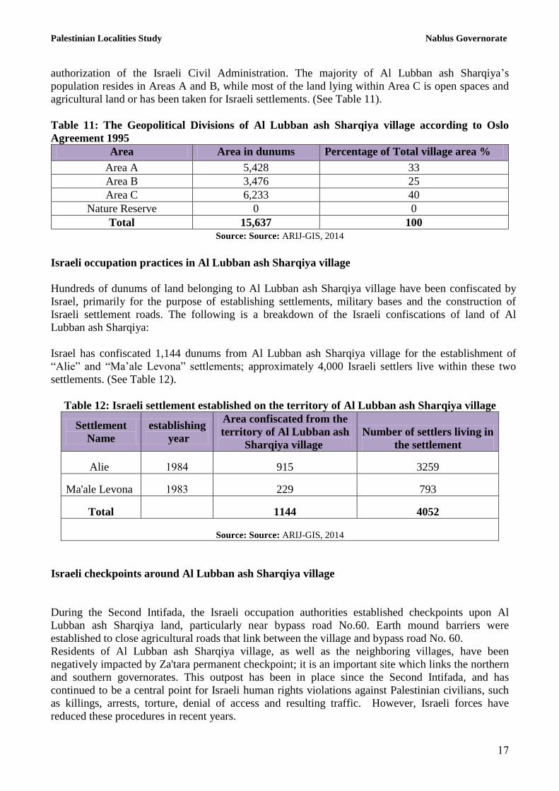
Palestinian Localities Study Nablus Governorate
11
authorization of the Israeli Civil Administration. The majority of Al Lubban ash Sharqiya’s
population resides in Areas A and B, while most of the land lying within Area C is open spaces and
agricultural land or has been taken for Israeli settlements. (See Table 11).
Table 11: The Geopolitical Divisions of Al Lubban ash Sharqiya village according to Oslo
Agreement 1995
Percentage of Total village area % Area in dunums Area
33 5,428 Area A
25 3,476 Area B
40 6,233 Area C
0 0 Nature Reserve
100 15,637 Total
Source: Source: ARIJ-GIS, 2014
Israeli occupation practices in Al Lubban ash Sharqiya village
Hundreds of dunums of land belonging to Al Lubban ash Sharqiya village have been confiscated by
Israel, primarily for the purpose of establishing settlements, military bases and the construction of
Israeli settlement roads. The following is a breakdown of the Israeli confiscations of land of Al
Lubban ash Sharqiya:
Israel has confiscated 1,144 dunums from Al Lubban ash Sharqiya village for the establishment of
“Alie” and “Ma’ale Levona” settlements; approximately 4,000 Israeli settlers live within these two
settlements. (See Table 12).
Table 12: Israeli settlement established on the territory of Al Lubban ash Sharqiya village
Settlement
Name
establishing
year
Area confiscated from the
territory of Al Lubban ash
Sharqiya village
Number of settlers living in
the settlement
Alie 1.84 915 3259
Ma'ale Levona 1.83 229 793
Total 1144 4052
Source: Source: ARIJ-GIS, 2014
Israeli checkpoints around Al Lubban ash Sharqiya village
During the Second Intifada, the Israeli occupation authorities established checkpoints upon Al
Lubban ash Sharqiya land, particularly near bypass road No.60. Earth mound barriers were
established to close agricultural roads that link between the village and bypass road No. 60.
Residents of Al Lubban ash Sharqiya village, as well as the neighboring villages, have been
negatively impacted by Za'tara permanent checkpoint; it is an important site which links the northern
and southern governorates. This outpost has been in place since the Second Intifada, and has
continued to be a central point for Israeli human rights violations against Palestinian civilians, such
as killings, arrests, torture, denial of access and resulting traffic. However, Israeli forces have
reduced these procedures in recent years.
Palestinian Localities Study Nablus Governorate
18
Over the last decade, military checkpoints in the area have continued to have a negative impact on
the daily lives of residents. Checkpoints continue to hinder freedom of movement and sever the links
between Nablus city and the surrounding villages, as well as the connection between the villages and
their agricultural lands. This has resulted in heavy economic losses for residents of the village as they
are forced to travel further distances which takes more time, in order to reach their agricultural land,
especially when checkpoints are closed.
Israeli bypass roads on Al Lubban ash Sharqiya village
Israeli authorities have established multiple bypass roads across the West Bank, confiscating
thousands of dunums of agricultural and non-agricultural lands in order to link Israeli settlements to
each other and to separate the Palestinian community. These roads also serve to enhance Israeli
security control.. Israel has confiscated land on the east side of Al Lubban ash Sharqiya village in
order to construct Israeli bypass road No. 60. The old road has been transformed so as to link with
“Ma'ale Levona” settlement. These two roads extend approximately 7.4km onto Al Lubban ash
Sharqiya territory and isolate agricultural land.
Israeli occupation authorities have amended a section from the main bypass road No. 60, with a
length of approximately 6.5 km and connects the villages of Al Lubban ash Sharqiya and Sinjil, with
another bypass passage approaching the settlements of "Shilo and “Alie" at the expense of the
territory of Al Lubban ash Sharqiya village and the neighboring villages, Israel dominated the old
section to connect the settlement of "Ma'ale Levona" with road No.60 Street, as we mentioned
earlier.
It should be noted that the real danger of the bypass roads lies in the amount of the confiscated lands
which will be taken for the purpose of what is known as the (buffer zone). The buffer zone is
imposed by the Israeli army and usually occupies 75 meters on both sides of the road.
Settler attacks on Al Lubban ash Sharqiya village
Attacks and violence perpetrated by settlers living in the settlements on Al Lubban ash Sharqiya land
have had a profoundly negative impact on village residents and their property. Palestinian land
owners are unable to access their lands, as they have been fenced off with barbed wire. Settlers have
planted trees in these areas to reinforce their control over the area. The settlers have damaged and
burned a number of Palestinian owned trees and plants. Settlers have also attacked the land owners in
an attempt to intimidate and deter them from returning to their land.
Israel has confiscated land from Al Lubban ash Sharqiya and the neighboring villages in order to
establish illegal settlements in the area for the purpose of the establishment of Israeli settlements. But
also these settlements pose a real threat for the Palestinians on their own land. Since the establishment
of these settlement, Palestinian residents have been subjected to several violent attacks from settlers
living in these settlements, for example farmers have been attacked in order to prevent them from
reaching their agricultural land. Settlers have also stolen crops, damaged trees and attacked homes,
cars and other private property, and places of worship, for example, the village mosque was razed in
2010.
Palestinian Localities Study Nablus Governorate
1.
Israeli outposts in the village of Al Lubban ash Sharqiya
Some of Al Lubban ash Sharqiya village lands were taken by force by the Israeli settlers for the
purpose of establishing three settlement outposts on the eastern side of "Alie" settlement, which is
partially built on land confiscated from 'Asira al Qibliya. These outposts overlook the village of ‘Al
Lubban ash Sharqiya, with the aim of extending the territory controlled along the western side of the
settlement, and as a result, control more Palestinian land. These outposts form a security barrier
which surrounds the Palestinian areas and its population and is a source of abuses and violations
against Palestinian civilians and their land.
During the past two decades, Israel has built 232 outposts in the West Bank, which later became
known as settlement outposts. The outposts are foundations for new settlements, and tend to be
extended branches of a mother settlement a few miles away. The process usually begins with the
establishment of mobile caravans on the land that has been taken by the settlers. Establishing
settlement outposts was encouraged by Ariel Sharon; the aim was for Jewish settlers to occupy
Palestinians hill tops and create facts on the ground, so that Palestinians could not claim the land if
there was ever to be a future solution between the two sides. Consecutive Israeli governments have
provided security and logistical support for these outposts. Since 2001 when Ariel Sharon became
Prime Minister, there has been a significant increase in the number of outposts across the West Bank. The Israeli army has also supported illegal Israeli settlers in their relocation to the settlements, in
addition to providing security and infrastructure support. This is to ensure the permanence of the
settlements.
Development Plans and Projects
Implemented Projects
Al Lubban ash Sharqiya Village Council has implemented several development projects in Al
Lubban ash Sharqiya during the past five years (See Table 13).
Table 13: Implemented Development Plans and Projects in Al Lubban ash Sharqiya during the Last Five Years
Name of the Project Type Year Donor
Domestic water reservoir Water 2010 UNDP
Agricultural water resevoir Agriculture 2011 Spanish Government
Construction of roads Infrastructure 2012 CHF
Rehabilitation of 'Ammuriya - Khirbet Qeis roads Infrastructure 2012 World Vision Source: Al Lubban ash Sharqiya Village Council, 2013

Palestinian Localities Study Nablus Governorate
2.
Proposed Projects
Al Lubban ash Sharqiya Village Council, in cooperation with the village’s civil society organizations
and the village residents, hopes to implement several projects in the coming years. The project ideas
were developed during the Participatory Rapid Appraisal (PRA) workshop conducted by ARIJ staff
in the village. The projects are as follows, in order of priority from the viewpoints of the participants
in the workshop:
1 – The project for a sanitation system, and rehabilitation of the system for solid waste collection
2 - The need to create retaining walls
3 - The need to reclaim about 1,000 dunums of land
4 - The need to construct agricultural roads, length of 20km
5 - The need for agricultural productivity projects to support women
6 - The need to rehabilitate and pave road linkages between the areas of ‘Ammuriya and Khirbet
Qeis with the length of 4km
7 – The need to build a secondary school for girls
8 - The need to pave internal roads of 11km
9 - The need for projects to support the livestock sector and veterinary services
10 - The need for small productive projects to secure income for needy families

Palestinian Localities Study Nablus Governorate
21
Locality Development Priorities and Needs
Al Lubban ash Sharqiya suffers from a significant shortage of infrastructure and services. Table 14
shows the development priorities and needs in the village, according to the Village Council’s
perspective:
Table 14: Development Priorities and Needs in Al Lubban ash Sharqiya
No. Sector Strongly
Needed
Needed Not a
Priority
Notes
Infrastructural Needs
1 Opening and paving of roads * 7 km^
2 Rehabilitation of old water networks * 7 km
3 Extending the water network to cover new built up
areas *
7 km
4 Construction of new water networks *
5 Rehabilitation/ construction of new wells or springs * 9 springs
6 Construction of water reservoirs *
7 Construction of a sewage disposal network * 7 km
8 Construction of a new electricity network * 7 km
9 Providing containers for solid waste collection * 50 containers
10 Providing vehicles for collecting solid waste * One vehicle
11 Providing a sanitary landfill *
Health Needs
1 Building new clinics or health care centres *
2 Rehabilitation of old clinics or health care centres *
3 Purchasing medical equipment and tools *
Educational Needs
1 Building new schools * Female School
2 Rehabilitation of old schools * Female School
3 Purchasing new school equipment *
Agriculture Needs
1 Rehabilitation of agricultural lands * 10,000 dunums
2 Building rainwater harvesting cisterns * 250 wells
3 Construction of livestock barracks * 30 barracks
4 Provision of veterinary services *
5 Provision of seeds and hay for animals * 400 ton per year
6 Construction of new greenhouses * 100 greenhouses
7 Rehabilitation of greenhouses * 1 greenhouse
8 Provision of field crops seeds *
9 Provision of plants and agricultural supplies *
Other Needs
1 The need for equipment for the village council such
as: vehicle and Bagger bulldozer *
^ 7 km secondary roads Source: Al Lubban ash Sharqiya Village Council, 2013

Palestinian Localities Study Nablus Governorate
22
References:
Applied Research Institute - Jerusalem (ARIJ), 2014. Geographic Information Systems and
Remote Sensing Unit Database. Bethlehem - Palestine.
Applied Research Institute - Jerusalem (ARIJ), 2014. Geographic Information Systems and
Remote Sensing Unit; Land Use Analysis (2012) – Half Meter High Accuracy. Bethlehem -
Palestine.
Applied Research Institute - Jerusalem (ARIJ). 2013. Water & Environment Research Unit
Database (WERU). Bethlehem - Palestine.
Ministry of Education & Higher Education (MOHE) - Nablus, 2012. Directorate of Education;
A database of schools (2011/2012). Nablus – Palestine.
Palestinian Central Bureau of Statistics. 2009. Ramallah, Palestine: General Census of
Population and Housing Censuses, 2007.
Palestinian Ministry of Agriculture (MOA), 2010. Directorate of Agriculture data (2009/2010).
Nablus – Palestine.
Al Lubban ash Sharqiya Village Council, 2013.


![dpv-uk.com · PDF fileEndure of Thermal shock. ... Ash Silo wz Pneumatic Ash Handling System Layout Chimney Pressue Pump Ash Silo czX-Ð] cz ESP Ash Silo ESP Ash](https://img.pdfslide.us/doc/110x75/5abd4e267f8b9a7e418b6dff/dpv-ukcom-of-thermal-shock-ash-silo-wz-pneumatic-ash-handling-system-layout.jpg)