Embed Size (px)
Citation preview

Al Bireh City Profile
Prepared by
The Applied Research Institute – Jerusalem
Funded by
Spanish Cooperation
2012

Palestinian Localities Study Ramallah Governorate
1
Acknowledgments
ARIJ hereby expresses its deep gratitude to the Spanish Agency for International Cooperation for
Development (AECID) for their funding of this project.
ARIJ is grateful to the Palestinian officials in the ministries, municipalities, joint services councils,
village committees and councils, and the Palestinian Central Bureau of Statistics (PCBS) for their
assistance and cooperation with the project team members during the data collection process.
ARIJ also thanks all the staff who worked throughout the past couple of years towards the
accomplishment of this work.

Palestinian Localities Study Ramallah Governorate
2
Background
This report is part of a series of booklets, which contain compiled information about each city, town, and
village in the Ramallah Governorate. These booklets came as a result of a comprehensive study of all
localities in Ramallah Governorate, which aims at depicting the overall living conditions in the
governorate and presenting developmental plans to assist in developing the livelihood of the population
in the area. It was accomplished through the "Village Profiles and Needs Assessment;" the project
funded by the Spanish Agency for International Cooperation for Development (AECID).
The "Village Profiles and Needs Assessment" was designed to study, investigate, analyze and document
the socio-economic conditions and the needed programs and activities to mitigate the impact of the
current unsecure political, economic and social conditions in Ramallah Governorate.
The project's objectives are to survey, analyze, and document the available natural, human,
socioeconomic and environmental resources, and the existing limitations and needs assessment for the
development of the rural and marginalized areas in Ramallah Governorate. In addition, the project aims
at preparing strategic developmental programs and activities to mitigate the impact of the current
political, social, and economic instability with the focus on the agricultural sector.
All locality profiles in Arabic and English are available online at http://vprofile.arij.org.

Palestinian Localities Study Ramallah Governorate
3
Table of Contents
Location and Physical Characteristics __________________________________________________ 4
History ___________________________________________________________________________ 5
Religious and Archaeological Sites _____________________________________________________ 5
Education _________________________________________________________________________ 7
Health Status ______________________________________________________________________ 9
Economic Activities _________________________________________________________________ 9
Agricultural Sector _________________________________________________________________ 11
Institutions and Services ____________________________________________________________ 13
Infrastructure and Natural Resources _________________________________________________ 13
Impact of Israeli occupation _________________________________________________________ 16
Development Plans and Projects ______________________________________________________ 19
Implemented Projects _______________________________________________________________ 19
Locality Development Priorities and Needs _____________________________________________ 20
References: _______________________________________________________________________ 21
Palestinian Localities Study Ramallah Governorate
4
Al Bireh City Profile
Location and Physical Characteristics
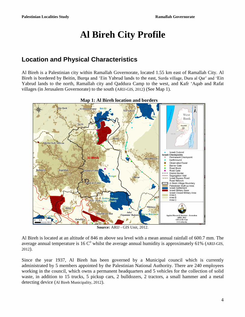
Al Bireh is a Palestinian city within Ramallah Governorate, located 1.55 km east of Ramallah City. Al
Bireh is bordered by Beitin, Burqa and „Ein Yabrud lands to the east, Surda village, Dura al Qar‟ and „Ein
Yabrud lands to the north, Ramallah city and Qaddura Camp to the west, and Kafr „Aqab and Rafat
villages (in Jerusalem Governorate) to the south (ARIJ-GIS, 2012) (See Map 1).
Map 1: Al Bireh location and borders
Source: ARIJ - GIS Unit, 2012.
Al Bireh is located at an altitude of 846 m above sea level with a mean annual rainfall of 600.7 mm. The
average annual temperature is 16 Co whilst the average annual humidity is approximately 61% (ARIJ-GIS,
2012).
Since the year 1937, Al Bireh has been governed by a Municipal council which is currently
administrated by 5 members appointed by the Palestinian National Authority. There are 240 employees
working in the council, which owns a permanent headquarters and 5 vehicles for the collection of solid
waste, in addition to 15 trucks, 5 pickup cars, 2 bulldozers, 2 tractors, a small hammer and a metal
detecting device (Al Bireh Municipality, 2012).
Palestinian Localities Study Ramallah Governorate
5
It is the responsibility of the municipal council to provide a number of services to the residents of Al
Bireh, including (Al Bireh Municipality, 2012):
Solid waste collection, road construction and restoration, street cleaning and social development
services.
The organization of construction and licensing processes.
Implementation of projects and studies for the city.
Provision of offices for governmental services, such as post and security.
Protection of historical and archeological city sites.
Provision and management of a sewerage network.
Provision of public markets.
Provision and management of kindergartens.
Provision of slaughterhouses and the organization of animal slaughtering.
History
Al Bireh carries a Canaanite name meaning „the wells‟, and is called thus as a result of the many water
springs which are located on Al Bireh lands. The city was established in 1928 and its residents today are
descendants of city‟s native citizens (Al Bireh Municipality, 2012).
Religious and Archaeological Sites
There are numerous mosques in the city (namely: Al Bireh Grand Mosque, Al Omari, Al Khulafa‟, Al
„Ein in addition to other mosques). The city has several sites of archaeological interest including:
Shiban, Najem and Abu Mujahid Shrines, the Church of the Holy Family, Al Khan (an inn) and At Tall
Mountain (Al Bireh Municipality, 2012) (See Map 2).

Palestinian Localities Study Ramallah Governorate
6
Map 2: Main locations in Al Bireh City
Population Source: ARIJ - GIS Unit, 2012.
Palestinian Localities Study Ramallah Governorate
7
According to the Palestinian Central Bureau of Statistics (PCBS), the total population of Al Bireh in
2007 was 35,910, of whom 17,986 were male and 17,924 female. There were additionally recorded to be
7,917 households living in 12,087 housing units.
Age Groups and Gender
The „General Census of Population and Housing‟ carried out by PCBS in 2007 showed the distribution
of age groups in Al Bireh is as follows: 34.3% were less than 15 years of age, 54.8% were between 15
and 64 years of age, and 3.7% were 65 years of age or older. Data additionally showed that the sex ratio
of males to females in the city is 100.3:100, meaning that males and females constitute 50.1% and
49.9% of the population, respectively.
Families
Al Bireh residents are from several families, including Hamayel, Qar‟an, „Abed, Karakra, At Taweel
and Ar Rafidi families (Al Bireh Municipality, 2012).
Education
According to the results of the PCBS „Population, Housing and Establishment Census‟-2007, the
illiteracy rate among Al Bireh population is approximately 3.6%, of whom 77.2% are females. Of the
literate population, 9.5% could only read and write, with no formal education, 18.1% had elementary
education, 22.3% had preparatory education, 18.8% had secondary education, and 27.5% completed
higher education. Table 1 shows the educational level in the city of Al Bireh by sex and educational
attainment in 2007.
Table 1: Al Bireh population (10 years and above) by sex and educational attainment
S
E
x
Illite-
rate
Can
read &
write
Element-
ary
Preparat-
ory
Second-
ary
Associate
Diploma Bachelor
Higher
Diploma Master
PhD Un-
known Total
M 205 1,167 2,324 2,809 2,264 811 1,921 65 539 181 35 12,321 F 696 1,176 2,165 2,711 2,393 1,184 1,790 40 248 34 32 12,469
T 901 2,343 4,489 5,520 4,657 1,995 3,711 105 787 215 67 24,790 Source: PCBS, 2009.
There are 7 public schools in the city (all run by the Palestinian Ministry of Higher Education), 11
private schools, and one UNRWA school (Directorate of Education in Ramallah, 2011) (see Table 2).
Palestinian Localities Study Ramallah Governorate
8
Table 2: Schools in Al Bireh by name, stage, sex, and supervising authority (2011/2012) School Name Supervising Authority Sex
Al Bireh Girls Secondary School Government Females
Al Bireh Co-educated Elementary School Government Mixed
Al Bireh Expatriates Co-educated Elementary School Government Mixed
Al Hashimiya Boys Secondary School Government Males
The New Dawn Co-educated Elementary School Government Mixed
The Unity Boys Elementary School Government Males
The Good Future Boys Secondary School Government Males
The Islamic Garden Elementary School Private Mixed
Al Bireh Sharia Secondary School Private Males
The Islamic Girls Secondary School Private Mixed
Khalil ar Rahman Elementary School Private Mixed
Muhammad ben Rashid al Maktoum Private School Private Mixed
Al Anwar Elementary School Private Mixed
The Jordanian Secondary School (Palestine Academy) Private Mixed
The Boys Islamic Secondary School Private Males
Al Qabs Secondary School for Optical Disability Private Mixed
An Najah Girls Secondary School Private Mixed
Al Khatib Elementary School Private Mixed
Al Am‟ari Boys Elementary School UNRWA Males Source: Directorate of Education in Ramallah, 2011
In the city there are 8,552 students, 523 teachers, and 317 classes. The average number of students per
teacher in the school is nearly 16, whilst the average number of students per class is approximately 27
(Directorate of Education in Ramallah, 2012).
There are 16 kindergartens in Al Bireh city run by different bodies. 1,575 children in total attend these
kindergartens (Directorate of Education in Ramallah, 2012) (See table 3 below).
Table 3: Kindergartens in Al Bireh city by name and supervising authority
Name of Kindergarten No. of Children Supervising Authority
The Little Angel Kindergarten 22 Private
An Najah Kindergarten 295 Other private
Baby World Kindergarten 112 Other private
Lafta Charitable Society Kindergarten 27 Other private
Children of Hope Kindergarten 55 Christian Civil
The Elementary Model Kindergarten 32 Islamic Civil
Palestine Academy Kindergarten 22 Other private
Al Anwar Kindergarten 144 Other private
Al „Awa‟el Kindergarten 172 Christian Civil
Al Jameel Kindergarten 82 Other private
Al Khatib Kindergarten 136 Other private
Al Huda Kindergarten 79 Other private
Family Revival Society Kindergarten/ Al Bireh 75 Islamic Civil
Children Paradise Model Kindergarten 222 Islamic Civil

Palestinian Localities Study Ramallah Governorate
9
Birds of Paradise Kindergarten 49 Other private
Muhammad ben Rashid Kindergarten 77 Christian Civil Source: Directorate of Education in Ramallah, 2012
Health Status
Al Bireh has 6 hospitals: Musallam Eye Hospital, Ar Razi Eye Hospital, the Military Medical Services
Hospital, Khalid Hospital, the Future Hospital and the Red Crescent Hospital. There is also a
governmental health center, a governmental mother and child care center, 5 private medical laboratories,
32 private pharmacies, and a number of private dental clinics, private physician gynecologist and
pediatrician clinics (Al Bireh Municipality, 2012).
Economic Activities
The economy in Al Bireh is dependent on several economic sectors, primarily the trade and services
sectors each of which absorbs 25% of the city workforce (Al Bireh Municipality, 2012) (See Figure1).
The results of a field survey conducted by the ARIJ team in 2012 for the distribution of labor by
economic activity in Al Bireh are as follows (Al Bireh Municipality, 2012):
Trade Sector (25%)
Services Sector (25%)
Government or Private Employees Sector (20%)
Industry (15%)
Agriculture Sector (10%)
Israeli Labor Market (5%)

Palestinian Localities Study Ramallah Governorate
12
Figure 1: Economic Activity in Al Bireh City
Source: Al Bireh Municipality, 2012
Al Bireh has 143 groceries, 17 vegetable and fruit stores, 36 bakeries, 34 butcheries, 936 service stores,
130 various professional workshops, 9 stone cutters, 12 driving schools, 43 garages, 65 restaurants, 63
coffee shops, 9 internet cafes, 7 factories, 9 libraries, 4 hotels, and 10 banks (Al Bireh Municipality, 2012).
Labor Force
According to the PCBS Population, Housing and Establishment Census-2007, 40.6% of Al Bireh labor
force was economically active, of whom 92.9% were employed, 58.9% were not economically active,
54% were students, and 33.3% were housekeepers (See Table 4).
Table 4: Al Bireh population (10 years of age and above) by sex and employment status
S
e
x
Economically active Non-economically active
Total Employ-
ed
Currently
Unem-
ployed
Un-
employed
(never
worked)
Total Stud-
ent
House-
keeping
Unable
to
work
Not
working
& not
looking
for work
Others Total Not
stated
M 6,806 278 197 7,281 3,883 7 539 317 194 4,940 100 12,321
F 2,536 124 120 2,780 3,989 4,844 665 117 34 9,649 40 12,469
T 9,342 402 317 10,061 7,872 4,851 1,204 434 228 14,589 140 24,790 M: Male; F: Female; T: Total.
Source: PCBS, 2009.

Palestinian Localities Study Ramallah Governorate
11
Agricultural Sector
Al Bireh has a total area of around 20,491 dunums of which 5,824 are considered „arable‟ lands and
5,263 dunums are registered as „residential‟ (See Table 5 and Map 3).
Table 5: Land use and land cover in Al Bireh city in 2010 (area in dunum)
Total
Area
Built
up
Area
Agricultural area
(5,824)
Inland
water
Forests Open
Spaces
Area of
Industrial,
Commercial &
Transport Unit
Area of
Settlements,
Military
Bases &
Wall Zone
Permanent
Crops
Green-
houses
Range-
lands
Arable
lands
20,491 5,263 1,779 1 288 3,756 0 0 5,636 860 2,908
Source: ARIJ – GIS Unit, 2012.
Map 3: Land use/land cover and Segregation Wall in Al Bireh City
Source: ARIJ - GIS Unit, 2012.
Table 6 shows the different types of rain-fed and irrigated open-cultivated vegetables in Al Bireh. The
most commonly cultivated crops within this area are tomatoes and squash.
Table 6: Total area of rain-fed and irrigated open cultivated vegetables in Al Bireh (area in dunums)

Palestinian Localities Study Ramallah Governorate
12
Fruity
vegetables
Leafy
vegetables Green legumes Bulbs
Other
vegetables Total Area
Rf. Irr. Rf. Irr. Rf. Irr. Rf. Irr. Rf. Irr. Rf. Irr.
15 0 0 2 5 0 0 0 0 0.5 20 2.5 Rf.: Rain-fed; Irr.: Irrigated.
Source: Ministry of agriculture-Ramallah, 2009
Table 7 shows the different types of fruit trees planted in the area. Al Bireh is famous for olive
cultivation and consequently there are 708 dunums of land planted with olive trees in the city.
Table 7: Total area of horticulture and olive trees in Al Bireh (area in dunums)
Olives Citrus Stone-fruits Pome fruits Nuts Other fruits Total Area
Rf. Irr. Rf. Irr. Rf. Irr. Rf. Irr. Rf. Irr. Rf. Irr. Rf. Irr.
708 0 0 0 21 0 1 0 10 0 45 0 785 0 Rf.: Rain-fed; Irr.: Irrigated.
Source: Ministry of agriculture-Ramallah, 2009
In terms of field crops and forage in Al Bireh, cereals (particularly wheat) are the most cultivated,
covering an area of approximately 35 dunums (See Table 8).
Table 8: Total area of horticulture and olive trees in Al Bireh (area in dunums)
Cereals Bulbs Dry
legumes Oil crops
Forage
crops
Stimulatin
g crops
Other
crops Total Area
Rf. Irr. Rf. Irr. Rf. Irr. Rf. Irr. Rf. Irr. Rf. Irr. Rf. Irr. Rf. Irr.
35 0 18 0 20 0 0 0 0 0 0 0 0 0 73 0 Rf.: Rain-fed; Irr.: Irrigated.
Source: Ministry of agriculture-Ramallah, 2009
The difference between the two sets of results obtained from the Ministry of Agriculture and by ARIJ‟s
GIS Unit in sizes of agricultural areas is explained by the fact that the Ministry of Agriculture and the
Palestinian Central Bureau of Statistics (2010) conducted a survey which used a definition of
agricultural areas based on land ownership. Therefore, the areas included in the survey were those of
actual holdings of agricultural areas instead of seasonal ones. The survey did not consider fragmented
and small seasonal cultivated areas in residential and agricultural areas. ARIJ‟s survey, however,
includes the existence of a high proportion of small and fragmented holdings (home gardens) throughout
the occupied Palestinian territories, thus accounting for the larger area of agricultural holdings calculated
by ARIJ.
The field survey conducted by ARIJ shows that not many of the residents in Al Bireh rear and keep
domestic animals such as sheep and goats (Al Bireh Municipality, 2012) (See Table 9).
Table 9: Livestock in Al Bireh
Cows* Sheep Goats Camels Horses Donkeys Mules Broilers Layers Bee
Hives
0 422 496 0 0 0 0 4,800 23,600 0 *Including cows, bull calves, heifer calves and bulls
Source: Palestinian Ministry of Agriculture - Ramallah, 2009
There are no agricultural roads in the city (Al Bireh Municipality, 2012).

Palestinian Localities Study Ramallah Governorate
13
The agricultural sector in the city faces problems, including (Al Bireh Municipality, 2012):
The confiscation of lands for the purpose of settlement construction close to the city.
The lack of agricultural labor force sufficient to exploit lands.
The lack of economic viability in agricultural projects.
The implementation of agricultural projects is limited to these with no need of water, due to the
scarcity of water in the city.
The lack of economic capital for entrepreneurial projects.
Institutions and Services
Al Bireh city has several governmental institutions: a post office, post division, fire station, police
station, a national security center, offices for the Ministries of Labor, Agriculture, Social Affairs,
Interior and a Chamber Commerce. It also has a number of local institutions and associations which
provide services to various sectors of society. These include (Al Bireh Municipality, 2012):
Al Bireh Municipality: Founded in 1937 and currently registered in the Ministry of Local
Government, the municipality takes care of the city issues and provides different services to its
residents.
Al Bireh Cultural Club.
Al Bireh Youth Institution.
Revival of Family Society.
Sports Unity Club.
Infrastructure and Natural Resources
Electricity and Telecommunication Services:
Al Bireh has been connected to a public electricity network since 1942. It is served by Jerusalem
Electricity Company, which is the main source of electricity in the city, and approximately 95% of the
housing units in the city are connected to this network (Al Bireh Municipality, 2012).
Al Bireh is additionally connected to a telecommunication network. Approximately 90% of the housing
units within the city boundaries are connected to phone lines (Al Bireh Municipality, 2012).
Transportation Services:
There are 110 public taxis in Al Bireh to serve the residents (Al Bireh Municipality, 2012). There are 12 km
of main roads and 144 km of secondary roads in Al Bireh (See Table 10) (Al Bireh Municipality, 2012).

Palestinian Localities Study Ramallah Governorate
14
Table 10: Roads in Al Bireh city
Status of Internal Roads Road Length (km)
Main Sub
1. Paved & in good condition 4 76
2. Paved but in poor condition 8 39
3. Unpaved - 29 Source: Al Bireh Municipality, 2012
Water Resources:
Al Bireh is provided with water by the Jerusalem Water Authority through the public water network
established in 1950. Approximately 95% of the housing units are connected to this network (Al Bireh Municipality, 2012)
The quantity of water supplied to Al Bireh city in 2010 was approximately 1,635,717 cubic meters. The
estimated rate of water supply is therefore calculated per capita, at approximately 125 liters/day.
However, no Al Bireh citizen consumes this amount of water due to water losses, which are estimated at
26.5%. These losses typically occur at the main source, major transport lines, in the distribution
network, and at the household level. Therefore, the rate of water consumption per capita in Al Bireh is
92 liters per day (Jerusalem Water Authority, 2011). This is considered a low rate compared with the
minimum quantity proposed by the World Health Organization, which is set at 100 liters per capita per
day.
To determine water costs, the water authority has adopted an upward rate system where the price of
water increases alongside increasing consumption. Table 12 shows the price of water by category of
consumption.
Table 11: Water tariffs of Jerusalem Water Authority adopted since 01.01.2012
Consumption
Category
(m³)
Domestic
(NIS/m³)
Industrial
(NIS/m³)
Tourist
(NIS/m³)
Commercial
(NIS/m³)
Public
Institutions
(NIS/m³)
0 – 5 4.5 5.6 5.6 5.6 5.4
5.1 – 10 4.5 5.6 5.6 5.6 4.5
10.1 – 20 5.6 6.8 6.8 6.8 5.6
20.1 – 30 6.8 8.1 8.1 8.1 6.8
30.1+ 9 9.9 10.8 9 9
Source: Jerusalem Water Authority, 2012
Sanitation:
Al Bireh has been connected to a public sewerage network since 1950 (Al Bireh Municipality, 2012).
According to the results of a community survey conducted by the Applied Research Institute –
Jerusalem (ARIJ) in 20101, 92% of Shabtin housing units use the sewage network as a means for
wastewater disposal, while the rest of housing units (8%) use cesspits (ARIJ & CENTA, 2010).
1 As part of the project "A Proposed Environmentally Sound Wastewater Management System for the West Bank"

Palestinian Localities Study Ramallah Governorate
15
Based on the estimated daily per capita water consumption, the estimated amount of wastewater
generated per day is approximately 2635 cubic meters, or 961,802 cubic meters annually. At the
individual level in the city it is estimated that the per capita wastewater generation is 46 liters per day,
depending on the consumption rate. The estimated amount of wastewater collected through the sewerage
network is approximately 884,858 cubic meters annually. Also, approximately 76,944 cubic meters of
wastewater is being collected by cesspits and discharged by wastewater tankers. It is worth mentioning
that wastewater flowing in the sewerage network is being treated in the wastewater treatment unit in Al
Bireh city. Citizens pay an amount of 1.8 NIS per each cubic meter of consumed water for the services
of the sewerage network and wastewater treatment (Al Bireh Municipality, 2012).
However, the wastewater collected by cesspits is discharged by wastewater tankers directly to open
areas or nearby valleys with no treatment which poses a serious threat to both environmental and public
health (ARIJ - WERU, 2012).
Solid Waste Management:
Al Bireh Municipality is responsible for the collection and disposal of solid waste generated by citizens
and establishments in the city. As the process of solid waste management is costly, a yearly fee
amounting to 36 Jordanian Dinar (JD)/ year is charged to the population served by domestic solid waste
collection and transportation services. However, the collected fees are not sufficient for good
management of solid waste. In addition only 30% of these fees are collected from the citizens, thus Al
Bireh Municipality covers the rest of costs from its operational budget (Al Bireh Municipality, 2012)
Most of the population in Al Bireh benefits from the solid waste services, whereby waste is collected
from households, institutions, shops, and public squares in plastic bags, and placed in containers
distributed throughout the city‟s neighborhoods. The Municipality collects the solid waste once a day
and transports it using the municipality‟s waste vehicle (the municipality owns 6 vehicles, each of 21
cubic meters capacity) to Al Bireh municipality dumping site, 2 km from the city, where it is buried (Al
Bireh Municipality, 2012). The disposal of solid waste in this dumping site costs 30 NIS per ton (Al Bireh
Municipality, 2012).
The daily per capita rate of solid waste production in Al Bireh is 1.05kg. Thus the estimated amount of
solid waste produced per day from the Al Bireh residents is nearly 37.7 tons, or 13,762.5 tons per year
(ARIJ-WERU, 2012).
Environmental Conditions
Like other cities, towns and villages in the governorate, Al Bireh experiences several environmental
problems which must be addressed and solved. These problems can be identified as follows:
Water Crisis
Water is cut off by the Jerusalem Water Authority for long periods of time during summer in
several neighborhoods of the city for several reasons:

Palestinian Localities Study Ramallah Governorate
16
(1) Israeli control over Palestinian water resources causes problems in the organization of water
pumping and its distribution among populations. The Jerusalem Water Authority distributes
water to various areas on an interval basis because the amount of water available is not
sufficient to supply everyone‟s needs simultaneously.
(2) High rate of water losses, because the water network is old and in need of rehabilitation and
renovation.
Wastewater Management
The absence of a public sewage network in some neighborhoods (8% of the neighborhoods)
means that Al Bireh residents are forced to use unhygienic cesspits for the disposal of
wastewater, and/or to discharge wastewater in the streets. This is particularly common in winter,
as citizens cannot afford the high cost of sewage tankers during this period. These methods
facilitate environmental damage, health problems, and the spread of epidemics and diseases in
the city. This wastewater also contaminates the groundwater given that the majority of cesspits
are built without lining, allowing wastewater to enter into the ground and avoid the need to use
sewage tankers. Moreover, the untreated wastewater collected from cesspits by sewage tankers
is disposed of in open areas without concern for the damage it causes to both the environment
and to residents' health.
Solid Waste Management:
The lack of a central sanitary landfill to serve Al Bireh and the other neighboring communities in
the governorate is due mainly to the bureaucratic obstacles created by the Israeli authorities for
local and national institutions in granting licenses to establish such a landfill. Often the reason
cited by Israeli forces is that the appropriate land to use for a sanitary landfill site falls with
classified area C, and therefore under full Israeli administrative and security control.
Additionally, the implementation of such projects depends on funding from donor countries. The
lack of a sanitary landfill is a source of pollution to the groundwater and soil through the leachate
produced from the solid waste, and produces bad odors and distortion of the landscape.
Impact of Israeli occupation
Geopolitical status in Al Bireh City According to the Oslo II Interim Agreement signed between the Palestinian Liberation Organization
(PLO) and Israel on 28th
September 1995, Al Bireh city was divided into politically classified areas “A”,
“B” and “C”. Approximately 8,157 dunums (39.8% of the city‟s total area) are classified as area “A”
where the Palestinian National Authority (PNA) holds all responsibilities for internal security and public
order. It is noted that most of the population in Al Bireh city resides in area “A”. 1,033 dunums (5% of
the city‟s total area) are classified as area B, where the Palestinian National Authority (PNA) has
complete control over civil matters and Israel continues to have overriding security responsibility. Area
“B” currently constitutes most of the inhabited Palestinian areas, including municipalities, villages and
some refugee camps. The rest of the city‟s area, constituting 11,302 dunums (55.2% of the total area), is

Palestinian Localities Study Ramallah Governorate
17
classified as area “C”, where Israel retains full control over security and administration related to the
territory (table 1). In area “C”, Palestinian building and land management is prohibited unless through a
consent or authorization by the Israeli Civil Administration. It is worth mentioning that most of the lands
lying within area “C” in the city are classified as open spaces, agricultural areas, Israeli settlements and
military bases, in addition to the existence of Palestinian urban and built-up areas within this area.
Table 12: The Geopolitical Divisions of Al Bireh City according to Oslo II Agreement 1995 – Ramallah
Governorate
Classification Area in dunums Percent from Total
city area
Area A 8,157 39.8
Area B 1,033 5
Area C 11,302 55.2
Nature Reserve 0 0
Total 20,493 100 Source: ARIJ-GIS, 2011
Al Bireh city and the Israeli Occupation Practices
The Israeli Occupation Forces (IOF) confiscated 1,126 dunums (5.5% of the city‟s total area) in Al
Bireh to establish two Israeli settlements: “Pesagot” and “Beit El.” Pesagot settlement was built wholly
on Al Bireh city territories (in its southern parts), whilst Beit El was semi built on the city‟s northern
territories, in addition to on the lands of Al Bireh and Dura al Qar‟ localities. The two settlements are
currently inhabited by more than 7,000 Israeli settlers (table 13).
Table 13: Israeli settlements established on the lands of Al Bireh City
Settlement’s
Population
2009
Area of lands
confiscated from
Al Bireh
Establishment
Date
Settlement Name
1623 780 1981 Pesagot
5499 346 1977 Beit El
7122 1126 Total Source: The Geo-informatics Department – ARIJ 2011
Moreover, Israeli Occupation Forces confiscated an additional 1,422 dunums (7% of the city‟s total
area) in Al Bireh to establish “Beit El” Military Base to the north of the city, which was built on its
territory near “Beit El” settlement. This Military Base includes the central Israeli Civil Administration
office in the West Bank in addition to a detention center and a military area. The Israeli Occupation
Forces (IOF) through establishment of these military bases in the heart of Palestinian territory are
aiming at intensifying their military presence within Palestine and strengthening their political and
security control over the Palestinian people.
IOF have established several barriers in Al Bireh city and its surroundings following the outbreak of the
second Intifada during the year 2000. The barriers remain today, with most of them located close to
“Beit El” settlement and military base. A permanent checkpoint was established at the eastern entrance
of Ramallah and Al Bireh near “Beit El”, which is located on the road that links the city with Israeli

Palestinian Localities Study Ramallah Governorate
18
controlled main road no. 60. This prevents Palestinians from entering and leaving the city of Ramallah,
which has added suffering to the Palestinians for more than twelve years who are now forced to drive for
long distances to enter or leave the city of Ramallah, and they have to use alternative roads with high
levels of traffic congestion. This is experienced especially at the Qalandiya Crossing south of Ramallah.
Moreover, the IOF established many other barriers in Al Bireh city including roadblocks (4 barriers),
road iron gates (3 Barriers) and earth-mounds (4 barriers) on the roads surrounding “Beit El” military
base to prevent the Palestinians from approaching this location. These barriers and restrictions also
prevents them from reaching the main road no. 60, restrict the movement of Palestinians and to
strengthen Israel‟s control over them.
Furthermore, IOF have also confiscated hundreds of thousands of dunums of Palestinian lands to
construct numerous Israeli bypass roads which are extended for thousands of kilometers over the West
Bank. These roads have resulted in the confiscation of agricultural and non-agricultural lands to connect
settlements and to divide Palestinian land in a way that strengthens security control over them. In Al
Bireh city, IOF have confiscated further lands to construct two Israeli bypass roads: the first connects
road no. 60 with “Beit El” settlement, and the second connects road no. 60 with “Pesagot” settlement,
with a total length of about 8 km for both roads. However, the real threat of bypass roads lies in the
buffer zone formed by the Israeli Occupation Forces (IOF) along these roads, extending to
approximately 75 m on the roads‟ sides.
In addition, lands of Al Bireh city have been forcefully seized by Israeli settlers to establish six Israeli
outposts around “Pesagot” and “Beit El” settlements in an attempt to expand these settlements and
controlling further Palestinian lands. It is noted that during the past two decades, Israel has constructed
232 outposts in the West Bank which are considered the nucleus for new settlement development
Outposts are typically composed of mobile caravans which are located on lands stolen by the settlers and
represent a contiguity of a near-by mother settlement. It is worth mentioning that the epidemic of Israeli
outposts started with a “Sharonian2” call for Jewish settlers to take control over Palestinian hilltops to
prevent transferring them to Palestinians in negotiations. Although the successive Israeli governments
haven‟t legalized this phenomenon, they have managed to find both security and logistical cover to
justify the act, existence and continuity. After 2001 the Prime Minister of that time, Ariel Sharon,
unleashed the expansion of outposts which has led to a significant increase in the number of outposts
within Palestinian areas. In addition, IOF have consistently aided Israeli settlers to move to these
outposts, through assisting them with the necessary security protection and infrastructure to guarantee
their continued existence.
2 Israeli Prime Minister Ariel Sharon (2001-2006)

Palestinian Localities Study Ramallah Governorate
19
Development Plans and Projects
Implemented Projects
Al Bireh Municipal Council has implemented several development projects in Al Bireh during the past
five years (See Table 14).
Table 14: Implemented Development Plans and Projects in Al Bireh during the Last Five Years
Name of the Project Type Year Donor
Developing the industrial zone Infrastructure 2011 Al Bireh Municipality
Establishing a garden Public Services 2006 State Fund
Paving and rehabilitating Nablus Road Infrastructure 2010-2011 Al Bireh Municipality & Ministry of Finance
Paving and rehabilitating Bir Zeit Road Infrastructure 2010 USAID & Ministry of Finance
Constructing the Turkish School Educational 2011 Turkey Embassy
Constructing the Future School Educational 2006-2007 Al Bireh Municipality
Constructing the Unity School Educational 2010 UNDP
The new lighthouse project Public Services 2011-2012 Al Bireh Municipality
Amending Al Bireh city structural plan Public Services 2012 Al Bireh Municipality
Source: Al Bireh Municipality, 2012

Palestinian Localities Study Ramallah Governorate
22
Locality Development Priorities and Needs
Al Bireh suffers from a significant shortage of infrastructure and services. Table 15 shows the
development priorities and needs in the city, according to the municipal council‟s point of view.
Table 15: Development Priorities and Needs in Al Bireh
No. Sector Strongly
Needed
Needed Not a
Priority
Notes
Infrastructural Needs
1 Opening and pavement of roads * 12.66 km^
2 Rehabilitation of old water networks * 135 km
3 Extending the water network to cover new built up
areas *
4 Construction of new water networks * 70 km
5 Rehabilitation/ construction of new wells or springs *
6 Construction of water reservoirs *
7 Construction of a sewage disposal network *
8 Construction of a new electricity network *
9 Providing containers for solid waste collection *
10 Providing vehicles for the collection of solid waste *
11 Provision of a sanitary landfill *
Health Needs
1 Building of new clinics or health care centres *
2 health centers
2 Rehabilitation of old clinics or health care centres * 1 health center
3 Purchasing new medical equipment and tools *
Educational Needs
1 Building new schools * all levels
2 Rehabilitation of old schools * all schools
3 Purchasing new equipment for schools *
Agriculture Needs
1 Rehabilitation of agricultural lands *
2 Building rainwater harvesting cisterns *
3 Construction of livestock barracks *
4 Provision of veterinary services *
5 Provision of seeds and hay for animals *
6 Construction of new greenhouses *
7 Rehabilitation of greenhouses *
8 Provision of Field crop seeds *
9 Provision of plants and agricultural supplies *
^ 8.73 km main roads and 3.93 km secondary roads Source: Al Bireh Municipality, 2012

Palestinian Localities Study Ramallah Governorate
21
References:
Applied Research Institute - Jerusalem (ARIJ), 2012. Geographic Information Systems and
Remote Sensing Unit Database. Bethlehem - Palestine.
Applied Research Institute - Jerusalem (ARIJ), 2012. Geographic Information Systems and Remote
Sensing Unit; Land Use Analysis (2010) – Half Meter High Accuracy. Bethlehem - Palestine.
Applied Research Institute - Jerusalem (ARIJ). 2012. Water & Environment Research Unit
Database (WERU). Bethlehem – Palestine.
Applied Research Institute - Jerusalem (ARIJ) & Spanish Centre of New Water Technologies
(CENTA) (2010). A Proposed Environmentally Sound Wastewater Management System for the
West Bank. 2010. Bethlehem – Palestine.
Al Bireh Municipality, 2012.
Jerusalem Water Authority (for Ramallah & Al Bireh areas) (2011). Detection showing the amount
of water sold from 1/1/2010 till 31/12/2010. Ramallah – Palestine.
Jerusalem Water Authority (2012). Jerusalem Water Authority's Website; Data Retrieved on the
first of March. http://www.jwu.org/newweb/atemplate.php?id=87.
Ministry of Education & Higher Education (MOHE) - Ramallah, 2011. Directorate of Education;
A database of schools (2010/2011). Ramallah – Palestine.
Palestinian Central Bureau of Statistics. 2009. Ramallah, Palestine: General Census of Population
and Housing Censuses, 2007.
Palestinian Ministry of Agriculture (MOA), 2009. Directorate of Agriculture data (2008/2009).
Ramallah - Palestine.