Embed Size (px)
Citation preview
1/54
Naama Initiative
Airspace Assessment
Analysis of Segregated Airspace for the
sUAS Activities in Urban Spaces
April 2020
2/54
Table of Contents
A Glossary of Abbreviations and Terms ................................................... 4
1. Background ................................................................................... 5
2. Reference Data ............................................................................... 7
3. Methodology .................................................................................. 9
4. Airspace Analysis Results ............................................................. 17
Comments:
The altitudes in the document are provided in feet above mean sea level (AMSL),
except where expressly noted otherwise.
The information extracted from AIP Israel is based on the 20/2 amendment (effective
date March 26, 2020).
The dimensions in the document are provided in accordance with Natinal Air
Regulations (dimensions), 5776 - 2016 (effective date March 28, 2016).
Important Comment: This document, including the airspace dedicated for sUAS activities in urban
environment, is intended to serve as advisory information for the initiative’s participants and is
subject to the final approval of the CAAI and IAF. The initiative’s participants are entitled to use
the data for the purpose of preparation and planning, under the assumption that it is possible that
changes and/or adjustments will be made, as part of the examination and approval process
implemented by CAAI and/or IAF.
3/54
A List of Tables and Figures
Figure 1 - A description of the Airspace Assessment process as part of Project Na’ama .................... 10
Figure 2 - Illustrating the delimitation of the activity areas .................................................................. 11
Figure 3 - Illustrating an analysis of aerial infrastructures in the North Tel Aviv and Bnei Brak area 12
Figure 4 - Illustrating surface analysis .................................................................................................. 13
Figure 5 - Analyzing aerial infrastructures opposite the requested work volume relative to the ground
level ....................................................................................................................................................... 14
Figure 6 - Classifying flight zones ........................................................................................................ 14
Figure 7 - Flight zone classification in the Tel Aviv - North Market airspace volume ....................... 18
Figure 8 - Flight zone classification in the Beersheva airspace ............................................................ 20
Figure 9 - Flight zone classification in the Ashdod airspace ................................................................ 23
Figure 10 - Flight zone classification in the Karmiel airspace ............................................................. 26
Figure 11 - Flight zone classification in the Jerusalem airspace .......................................................... 29
Figure 12 - Flight zone classification in the Haifa airspace .................................................................. 32
Figure 13 - Flight zone classification in the Eilat airspace ................................................................... 35
Figure 14 - Flight zone classification in the Sharonim Shopping Mall, Hod Hasharon airspace ........ 38
Figure 15 - Flight zone classification in the Kadima airspace .............................................................. 41
Figure 16 - Flight zone classification in the M Haderech airspace ...................................................... 44
Figure 17 - Flight zone classification in the Netanya airspace ............................................................. 47
Figure 18 - Flight zone classification in the Hadera airspace ............................................................... 51
Table1 - Concentrated data of examined airspace volumes ................................................................... 8
Table 2 - A concentration of data for the Tel Aviv - North Market airspace volume ......................... 18
Table 3 - A concentration of data for the Beersheva airspace volume ................................................. 20
Table 4 - A concentration of data for the Ashdod airspace volume ..................................................... 23
Table 5 - A concentration of data for the Karmiel airspace volume ..................................................... 26
Table 6 - A concentration of data for the Jerusalem airspace volume .................................................. 29
Table 7 - A concentration of data for the Haifa airspace volume ......................................................... 32
Table 8 - A concentration of Eilat airspace data ................................................................................... 35
Table 9 - A concentration of data for the Sharonim Shopping Mall, Hod Hasharon airspace volume 38
Table 10 - A concentration of data for the Kadima airspace volume ................................................... 41
Table 11 - A concentration of data for the M Haderech airspace volume ............................................ 44
Table 12 - A concentration of data for the Netanya airspace volume................................................... 47
Table 13 - A concentration of data for the Hadera airspace volume .................................................... 51
4/54
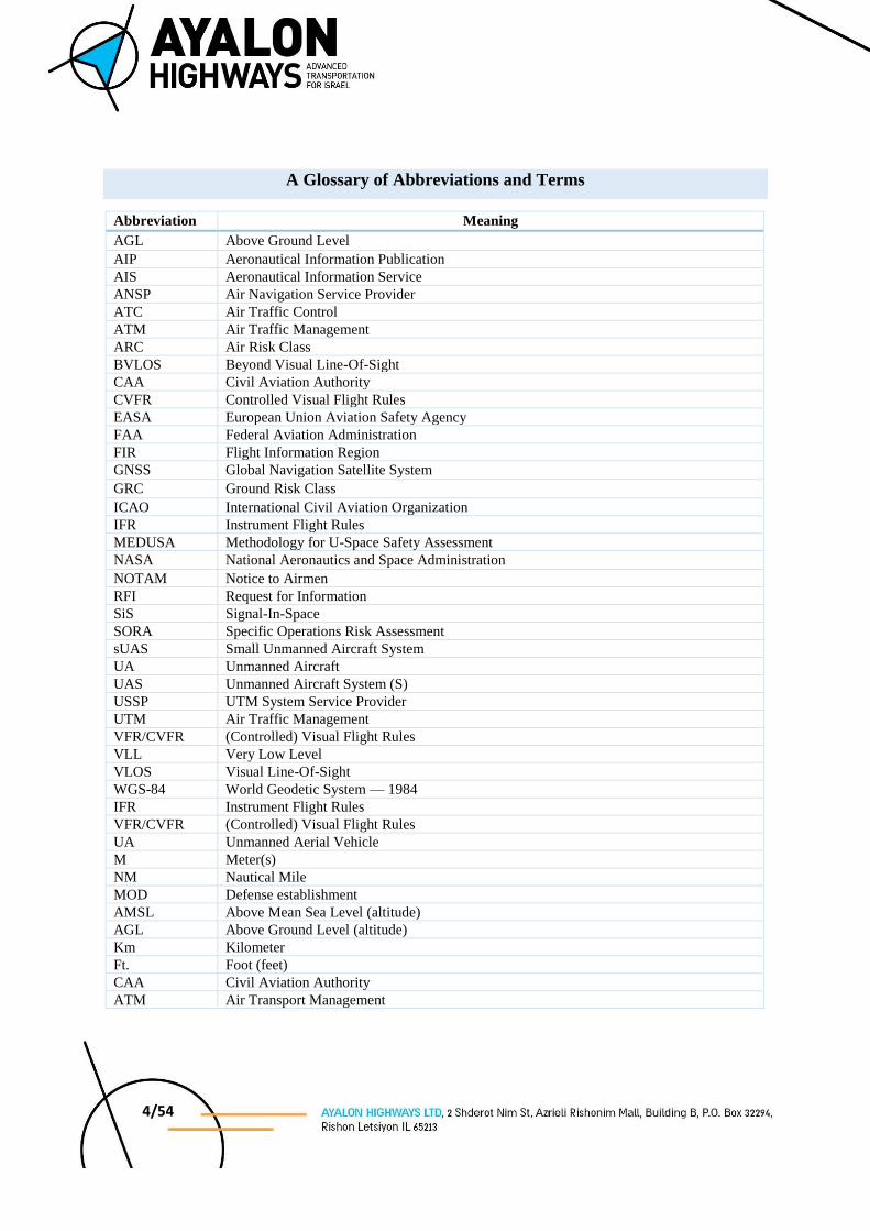
A Glossary of Abbreviations and Terms
Abbreviation Meaning
AGL Above Ground Level
AIP Aeronautical Information Publication
AIS Aeronautical Information Service
ANSP Air Navigation Service Provider
ATC Air Traffic Control
ATM Air Traffic Management
ARC Air Risk Class BVLOS Beyond Visual Line-Of-Sight CAA Civil Aviation Authority
CVFR Controlled Visual Flight Rules EASA European Union Aviation Safety Agency FAA Federal Aviation Administration FIR Flight Information Region
GNSS Global Navigation Satellite System
GRC Ground Risk Class
ICAO International Civil Aviation Organization
IFR Instrument Flight Rules
MEDUSA Methodology for U-Space Safety Assessment NASA National Aeronautics and Space Administration
NOTAM Notice to Airmen
RFI Request for Information
SiS Signal-In-Space
SORA Specific Operations Risk Assessment sUAS Small Unmanned Aircraft System
UA Unmanned Aircraft
UAS Unmanned Aircraft System (S)
USSP UTM System Service Provider
UTM Air Traffic Management
VFR/CVFR (Controlled) Visual Flight Rules VLL Very Low Level VLOS Visual Line-Of-Sight
WGS-84 World Geodetic System — 1984 IFR Instrument Flight Rules VFR/CVFR (Controlled) Visual Flight Rules
UA Unmanned Aerial Vehicle M Meter(s)
NM Nautical Mile
MOD Defense establishment
AMSL Above Mean Sea Level (altitude) AGL Above Ground Level (altitude) Km Kilometer
Ft. Foot (feet)
CAA Civil Aviation Authority ATM Air Transport Management
5/54
1. Background
AGL Aviation LTD was requested to conduct an assessment and analysis of the national
airspace of the State of Israel in order to identify certain airspace volumes that can be used by
sUAS, as part of the Urban Mobility in the Aerial Dimension Project (hereinafter - Na’ama)
led by Ayalon Highways. The engagement of AGL Aviation in the Na’ama Project is executed
under the Matrix Co. The project’s objective is to facilitate enhanced utilization of unmanned
aerial vehicles (hereinafter - UA) in an urban environment. The airspace volumes that were
analyzed were selected after several discussions with stakeholders such as the defense
authorities, CAA, aircraft operators, suppliers and municipalities.
In Israel, the airspace is saturated with infrastructures serving various sectors of civil and
military aviation. The areas of interest defined for the project are a series of urban areas that
according to an initial analysis can potentially serve as a basis for economically feasible
commercial drone activity.
The aeronautical infrastructures in the areas of interest examined under the project serve
primarily general aviation (private and commercial), and low-flying Israel Air Force training
missions.
Any aeronautical infrastructure requires a defined volume for the operation and separation of
various aircraft, as well as separation from the ground and from obstacles, to supply an
acceptable level of safety for users of the airspace, as well as for people and property on the
ground.
In addition, the aerial infrastructure serving the various aviation sectors, were planned
according to the existing constraints and considerations in the examined areas of interest, which
in turn affect the airspace, for example, prohibited, restricted and dangerous areas for flight1.
Globally, projects such as the Na’ama Project are being promoted under the title of UAS Traffic
Management (hereinafter - UTM), which aims to bring UA activity to urban spaces, inter alia
by means of synchronizing with the existing Air Traffic Management system and creating
mechanisms which enable multiple UA activity in crowded urban areas. The regulatory
authorities that are leading the development of the UTM operating concept are SESAR and
1 These are published in AIP Israel, “Section ENR 5.1 - Prohibited, restricted and danger areas for flight” and in
specific areas where UA flight is prohibited.

6/54
Eurocontrol in a project called U-Space, and the FAA and NASA, which are leading in the US
the UTM Research Transition Team (RTT) Initiative.
UTM operational concept are in various stages of development throughout the world. A
fundamental component mentioned throughout the professional literature of the International
Civil Aviation Organization (ICAO) and the other leading regulatory authorities engaged in
UTM, is the analysis of the airspace (hereinafter - Airspace Assessment), which comprises a
preliminary phase for unmanned aerial vehicle activity in the airspace and understanding their
effect on the airspace.
An assessment of select airspace volumes was conducted in accordance with the methodology
developed under the auspices of the U-Space Project and underwent a process of operational
experimentation in the airspace of the control zone of the aerodrome in Riga, Latvia2.
The significance of the airspace volume assessment is the analysis of all the relevant aerial
infrastructure vis-a-vis the areas of interest that enable UA activity in the framework of Project
Na’ama. The analysis is conducted on the basis of the required platform and its characteristics,
for example, the required separation between UAs and manned aircraft, and the conversion of
altitude references (from AMSL to AGL), etc. The analysis’ results presented in Section 4 of
this document, will comprise a foundation for assessing possible UA activity in the airspace of
the State of Israel, and describe the airspace volumes available for activity and their unique
operational characteristics.
The document focuses on the aspects of airspace and airborne operations. It does not discuss
the separation of aircraft from obstacles and obstructions (structures, powerlines, antennas,
trees, etc.) as well as the topics of personal safety while flying above areas of high density and
changing importance (population concentrations, kindergartens, privacy sensitive areas and so
forth) in the framework of the UA activity in the airspace volumes that were assessed.
2 Eurocontrol, Final Report of Riga CTR Airspace Assessment, Edition 1.0, 29.11.2019

7/54
2. Reference data
An analysis of airspace volumes for future UA activity in the framework of Project Na’ama,
includes potential volumes for nine major cities throughout the country, from Karmiel in the
north to Eilat in the south, in addition to designated airspace volumes that were requested by
the proposing entities participating in the project.
These cities were selected as potential sites for UA activity in cooperation with the CAA, for
two main reasons. The first is that these are densely and highly populated cities, in which the
economic feasibility of various initiatives in fields pertaining to service to the individual (for
example, food and package deliveries, and so forth) exist in a higher probability than in areas
with a sparse population. The second, pertains to the cities’ location in relation to aerial
infrastructure. As previously noted, the airspace in the State of Israel is saturated with
infrastructures, and the selected sites were those that in the eyes of the CAA and the analysts,
were found to have a preliminary feasibility to incorporate UA activity as part of the project,
in addition to the existing infrastructure.
The airspace volume tested in each city, was determined as a 3 km radius from primary dispatch
points. The dispatch points were set in large-scale commercial centers, relatively clear of
obstacles, comprised of multiple relevant services compatible to air transport. Dispatch points
enable maximum coverage of the city’s area in a defined range. The volume altitude was set at
a minimum altitude of 40 meters AGL (approximately 130 feet AGL) as an assumption aiming
to minimize any exposure on the part of the public to noise, minimizing any invasion of privacy
and enhancing the safety of those individuals present within the area of the activity zone, in the
event of an aircraft malfunction/emergency. The maximum altitude of the airspace volume was
set at 120 meters AGL (approximately 400 feet AGL, that complies with the VLL definition of
U-space).
In addition to the airspace volumes selected by the CAA as potential areas (those having the
prospects of a relatively high level of applicability), additional activity areas were examined as
part of the support provided by Project Na’ama for the various company sponsored initiatives.
There is a certain advantage to performing an airspace assessment for the purpose of a
designated activity since the aircraft operator’s specifications are more precise, thus making it
possible to adapt the airspace volume in an optimal configuration for the proposed activity
while utilizing the acceptable planning indices in the UTM concepts noted above.
8/54
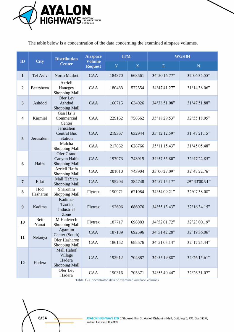
The table below is a concentration of the data concerning the examined airspace volumes.
ID City Distribution
Center
Airspace
Volume
Request
ITM WGS 84
Y X E N
1 Tel Aviv North Market CAA 184870 668561 34°50'16.77” 32°06'35.55”
2 Beersheva Azrieli
Hanegev
Shopping Mall CAA 180433 572554 34°47'41.27” 31°14'38.06”
3 Ashdod Ofer Lev
Ashdod
Shopping Mall CAA 166715 634026 34°38'51.08” 31°47'51.88”
4 Karmiel Gan Ha’ir
Commercial
Center CAA 229162 758562 35°18'29.53” 32°55'18.95”
5 Jerusalem
Jerusalem
Central Bus
Station CAA 219367 632944 35°12'12.59” 31°47'21.15”
Malcha
Shopping Mall CAA 217862 628766 35°11'15.43” 31°45'05.48”
6 Haifa
Ofer Grand
Canyon Haifa
Shopping Mall CAA 197073 743915 34°57'55.80” 32°47'22.85”
Azrieli Haifa
Shopping Mall CAA 201010 743904 35°00'27.09” 32°47'22.76”
7 Eilat Mall HaYam
Shopping Mall CAA 195204 384748 34°57'15.17” 29° 33'00.91”
8 Hod
Hasharon Sharonim
Shopping Mall Flytrex 190971 671084 34°54'09.21” 32°07'58.08”
9 Kadima
Kadima-
Tzoran
Industrial
Zone
Flytrex 192696 686976 34°55'13.43” 32°16'34.15”
10 Beit
Yanai M Haderech
Shopping Mall Flytrex 187717 698883 34°52'01.72” 32°23'00.19”
11 Netanya
Agamim
Center (South) CAA 187189 692596 34°51'42.28” 32°19'36.06”
Ofer Hasharon
Shopping Mall CAA 186152 688576 34°51'03.14” 32°17'25.44”
12 Hadera
Mall Hahof
Village
Hadera
Shopping Mall
CAA 192912 704887 34°55'19.88” 32°26'15.61”
Ofer Lev
Hadera CAA 190316 705371 34°53'40.44” 32°26'31.07”
Table 1 - Concentrated data of examined airspace volumes
9/54
3. Methodology
The methodology for the analysis and assessment of airspace, i.e. Airspace Assessment, is in
various phases of development across the globe, and is not included in any international or
largely accepted framework of regulation (such as EASA, ICAO or the FAA).
Currently, UA activity in various airspaces is conducted under the auspices of the Specific
Operational Risk Assessment (hereinafter - SORA), commonly acceptable by regulatory
authorities throughout the world, and in Israel in particular.
The UTM concept formulated by the two leading organizations, Eurocontrol and the FAA,
aspires to analyze the airspace in as a comprehensive manner as possible, to constitute a
foundation for generic flight activity of various aircraft operators, and thus absolving these
operators from conducting their won dedicated airspace assessment.
As stated, the methodology for executing an Airspace Assessment is in the development phase,
there are isolated test cases in which aa analysis of this type has been conducted, for example
the analysis of the Riga airspace as part of the U-Space project conducted by Eurocontrol. The
Airspace Assessment in Riga relies on adapting the SORA principles to a new methodology
known as MEDUSA.
The Airspace Assessment in the framework of Project Na’ama is based upon an adaptation of
the methodology noted above, as the most advanced UTM operational concept today. The
methodology contains five stages, as described in the figure below.
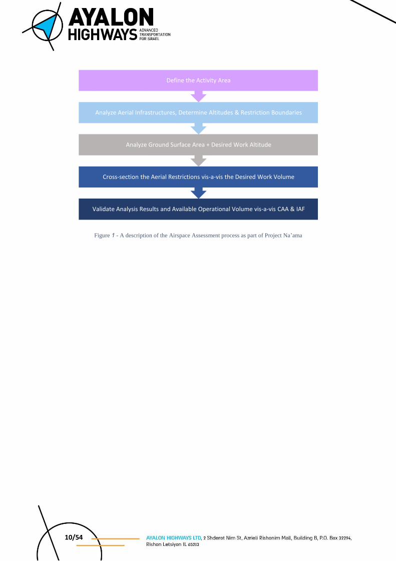
10/54
Figure 1 - A description of the Airspace Assessment process as part of Project Na’ama
Validate Analysis Results and Available Operational Volume vis-a-vis CAA & IAF
Cross-section the Aerial Restrictions vis-a-vis the Desired Work Volume
Analyze Ground Surface Area + Desired Work Altitude
Analyze Aerial Infrastructures, Determine Altitudes & Restriction Boundaries
Define the Activity Area
11/54
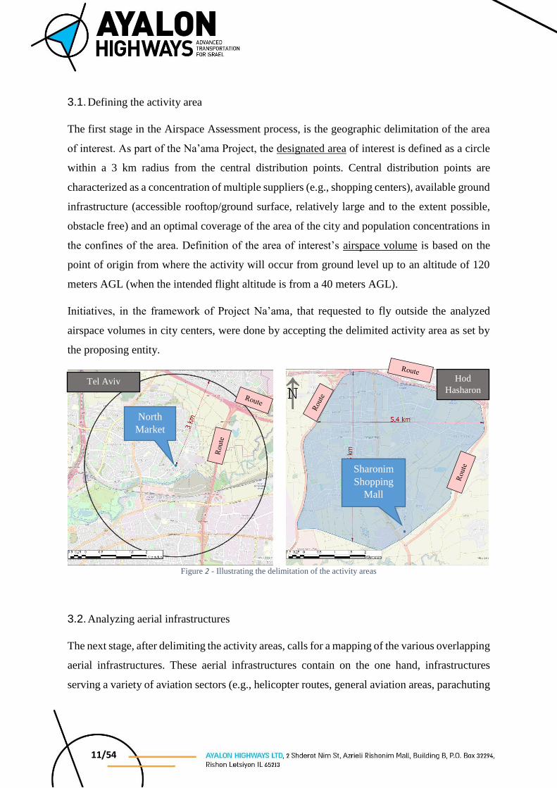
3.1. Defining the activity area
The first stage in the Airspace Assessment process, is the geographic delimitation of the area
of interest. As part of the Na’ama Project, the designated area of interest is defined as a circle
within a 3 km radius from the central distribution points. Central distribution points are
characterized as a concentration of multiple suppliers (e.g., shopping centers), available ground
infrastructure (accessible rooftop/ground surface, relatively large and to the extent possible,
obstacle free) and an optimal coverage of the area of the city and population concentrations in
the confines of the area. Definition of the area of interest’s airspace volume is based on the
point of origin from where the activity will occur from ground level up to an altitude of 120
meters AGL (when the intended flight altitude is from a 40 meters AGL).
Initiatives, in the framework of Project Na’ama, that requested to fly outside the analyzed
airspace volumes in city centers, were done by accepting the delimited activity area as set by
the proposing entity.
Figure 2 - Illustrating the delimitation of the activity areas
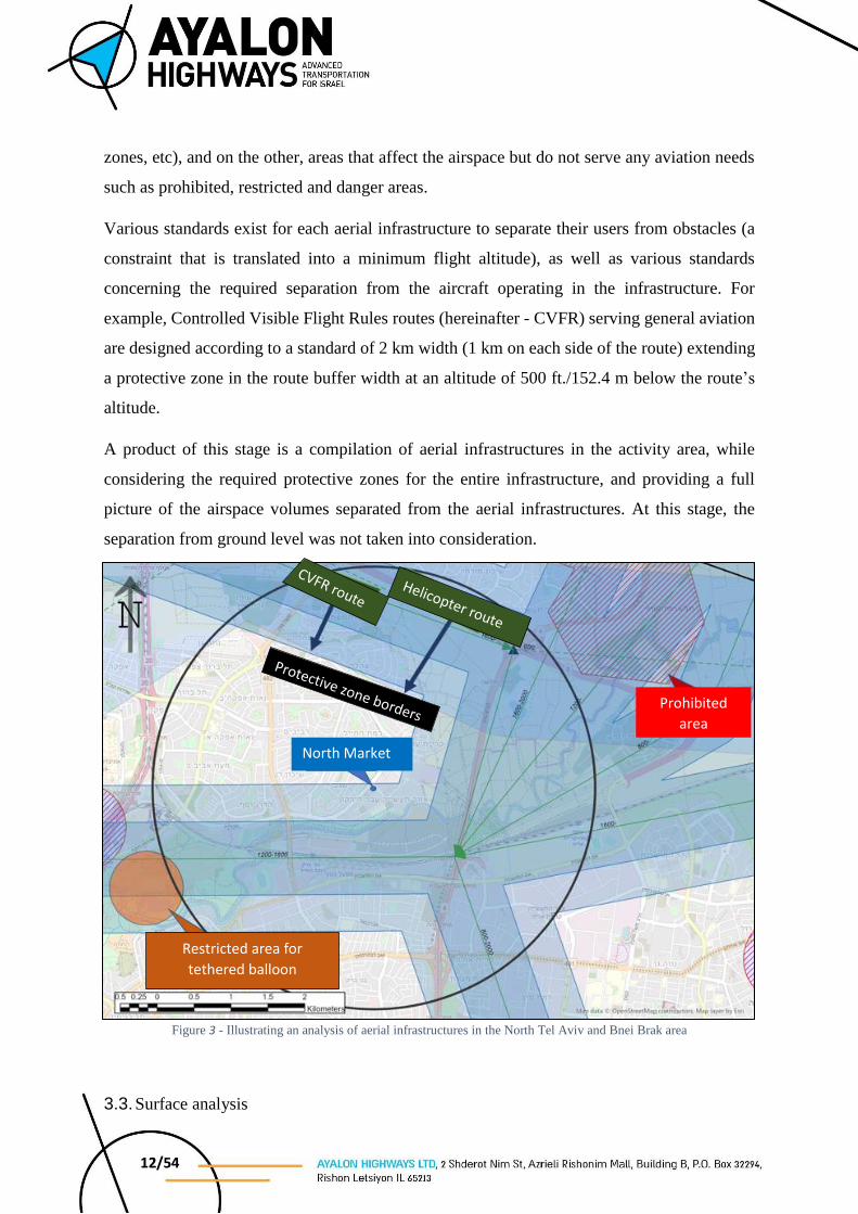
3.2. Analyzing aerial infrastructures
The next stage, after delimiting the activity areas, calls for a mapping of the various overlapping
aerial infrastructures. These aerial infrastructures contain on the one hand, infrastructures
serving a variety of aviation sectors (e.g., helicopter routes, general aviation areas, parachuting
Sharonim
Shopping
Mall
North
Market
Hod
Hasharon Tel Aviv
12/54
zones, etc), and on the other, areas that affect the airspace but do not serve any aviation needs
such as prohibited, restricted and danger areas.
Various standards exist for each aerial infrastructure to separate their users from obstacles (a
constraint that is translated into a minimum flight altitude), as well as various standards
concerning the required separation from the aircraft operating in the infrastructure. For
example, Controlled Visible Flight Rules routes (hereinafter - CVFR) serving general aviation
are designed according to a standard of 2 km width (1 km on each side of the route) extending
a protective zone in the route buffer width at an altitude of 500 ft./152.4 m below the route’s
altitude.
A product of this stage is a compilation of aerial infrastructures in the activity area, while
considering the required protective zones for the entire infrastructure, and providing a full
picture of the airspace volumes separated from the aerial infrastructures. At this stage, the
separation from ground level was not taken into consideration.
Figure 3 - Illustrating an analysis of aerial infrastructures in the North Tel Aviv and Bnei Brak area
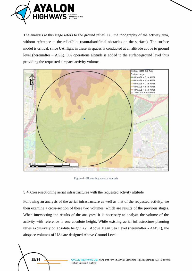
3.3. Surface analysis
North Market
Prohibited
area
Restricted area for
tethered balloon
13/54
The analysis at this stage refers to the ground relief, i.e., the topography of the activity area,
without reference to the relief/plot (natural/artificial obstacles on the surface). The surface
model is critical, since UA flight in these airspaces is conducted at an altitude above to ground
level (hereinafter – AGL). UA operations altitude is added to the surface/ground level thus
providing the requested airspace activity volume.
Figure 4 - Illustrating surface analysis
3.4. Cross-sectioning aerial infrastructures with the requested activity altitude
Following an analysis of the aerial infrastructure as well as that of the requested activity, we
then examine a cross-section of these two volumes, which are results of the previous stages.
When intersecting the results of the analyzes, it is necessary to analyze the volume of the
activity with reference to one absolute height. While existing aerial infrastructure planning
relies exclusively on absolute height, i.e., Above Mean Sea Level (hereinafter - AMSL), the
airspace volumes of UAs are designed Above Ground Level.
14/54
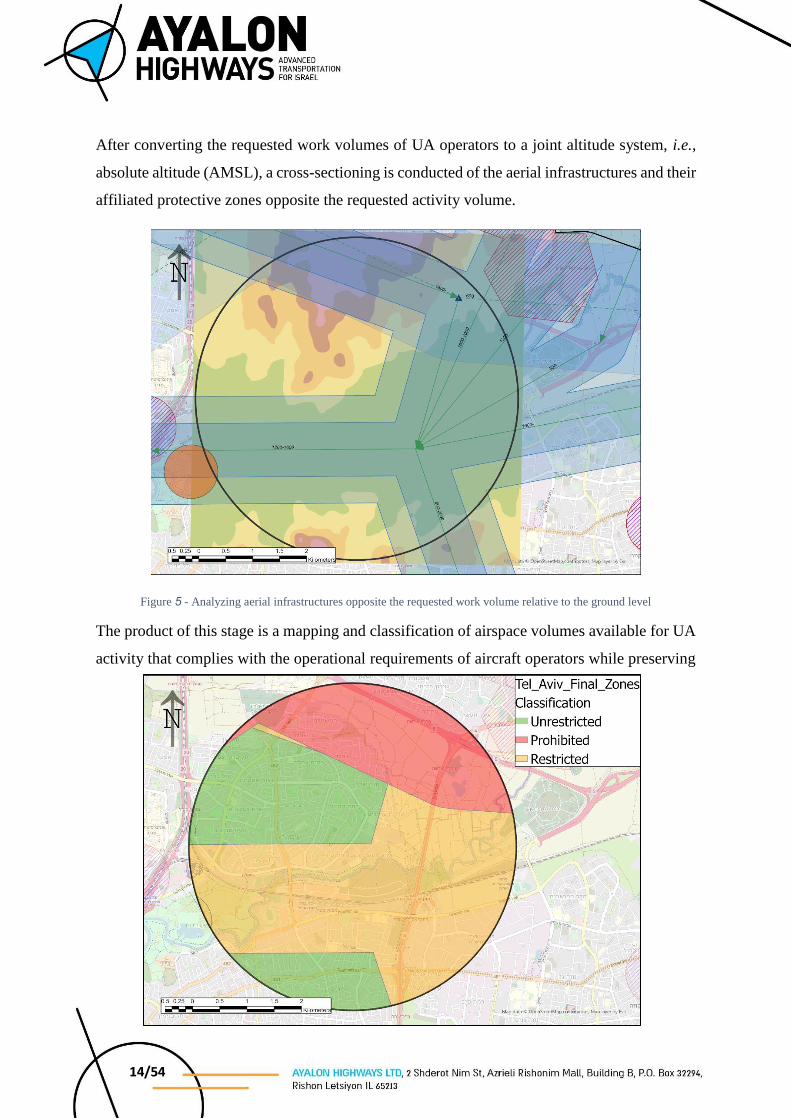
After converting the requested work volumes of UA operators to a joint altitude system, i.e.,
absolute altitude (AMSL), a cross-sectioning is conducted of the aerial infrastructures and their
affiliated protective zones opposite the requested activity volume.
Figure 5 - Analyzing aerial infrastructures opposite the requested work volume relative to the ground level
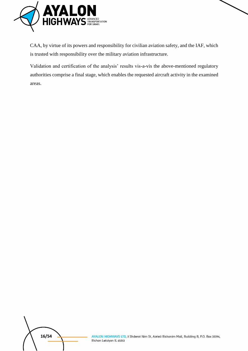
The product of this stage is a mapping and classification of airspace volumes available for UA
activity that complies with the operational requirements of aircraft operators while preserving
Figure 6 - Classifying flight zones

15/54
accepted standards for separation from aerial infrastructure, thus securing and ensuring an
acceptable level of safety. The UA area of operation is then classified into three different
classifications: An area of Unrestricted Operations, an area of Restricted Operations and an
area where activity is prohibited.
An area where activity is prohibited, which is marked in red, is an area where flight is
prohibited at the required minimum altitude of 40 MASL without infiltrating a protective zone
of another aerial infrastructure, thus endangering on one hand aircraft utilizing the neighboring
infrastructure (in the case of an infrastructure that cannot be coordinated).
An area of Unrestricted Operations, which is marked in green, is an area where it is possible to
operate at all of the requested altitudes, i.e., up to an altitude of 120 meters AGL, without any
restrictions, as long as manned aircraft activity in the area is routine3.
An area where activity is restricted, marked in orange, is where activity is permitted under
certain stipulations. For example, in the area of Yarkon Park, there is a restricted area relating
to the activity of a tethered hot-air balloon, and as such pre-flight preparations in the airspace
require coordination with the balloon operator to understand whether or not there is activity
during the requested timeframe. Additional stipulations can include certain altitude restrictions,
a restriction against activity during certain hours of the day, and so forth.
3.5. Validation of the analysis results
The final stage of the activity area analysis is a validation of the analysis results by the CAA
as the regulatory agency and responsible for the planning and development of the Flight
Information Region and of Air Transport Policy and Regulation in its jurisdiction4. This stage
will also contain references to the various stakeholders, such as relevant ATM units and
additional regulatory entities (MOD/IAF).
It should be clarified that the various existing aerial infrastructures in the Israeli airspace serve
a variety of sectors, which include both civil and military aircraft. Therefore, it is only correct
that the validation of the analysis’ results will be conducted by two regulatory entities, the
3 In other words, activity performed in the published aerial infrastructures, differentiated from emergency
activity by state aircraft and others (police, military, medical evacuation), an aircraft malfunction that requires
evacuation of the space or any security need requiring airspace evacuation. 4 Aviation Law, 5771-2011, Section D: Air Traffic Control Zone, Clause 82
16/54
CAA, by virtue of its powers and responsibility for civilian aviation safety, and the IAF, which
is trusted with responsibility over the military aviation infrastructure.
Validation and certification of the analysis’ results vis-a-vis the above-mentioned regulatory
authorities comprise a final stage, which enables the requested aircraft activity in the examined
areas.
17/54
4. Airspace Analysis
This section presents the products of the assessment of the selected airspace volumes in the
framework of Project Na’ama. As detailed in Clause 3.4, this product contains the general
details of each airspace volume, and the various flight zone classifications (unrestricted,
restricted and prohibited) in its boundaries.
It is important to note that the analysis does not set operational requirements and conditions for
activity, rather it defines the airspace volumes available for aerial activity solely within the
boundaries of the areas of interest. Any aircraft operator interested in operating in the specified
airspace volumes must confirm the approval of the activity in accordance with the airspace
assessment, opposite IAF and CAA as the regulatory authorities trusted with the task of
preserving flight safety in the State of Israel.

18/54
4.1. Tel Aviv - North Market
ID City Distribution
Center
Airspace
Volume
Developer
Airspace
Volume
Dimensions
The New Israel
Network WGS 84
Y X E N
4.1. Tel Aviv North
Market CAA 3 km radius 184870 668561 34°50' 16.77” 32°06' 35.55”
Table 2 - A concentration of data for the Tel Aviv - North Market airspace volume
The airspace volume that surrounds the “North Market” in Tel Aviv is positioned between
several different ATM units. The volume’s southern portion falls within the realm of the Ben
Gurion - LLBG tower control zone, and its other portion, the larger of them falls under the
control zone of the Air Force ATC Unit 506 (“Pluto” Control). In addition to the Ben Gurion -
LLBG control zone situated to the south of the airspace volume; in its northern portion sits is
the control zone belonging to the Herzliya Aerodrome - LLHZ, which serves multiple users in
the private and commercial, general aviation sector, as well as many helicopters flying at low
altitudes.
Most of the airspace volume is available for activity, where The airspace is divided according
to the following classification zones:
Figure 7 - Flight zone classification in the Tel Aviv - North Market airspace volume

19/54
Unrestricted Operations
In the zones classified in green, it is possible to operate unrestricted up to an altitude of 120
meters AGL.
Restricted Operations
In the zones classified in orange, it is only possible to operate up to an altitude of 91 meters
AMSL due to CVFR routes crossing at a minimal altitude of 800 FT. AMSL above the airspace
volume. It should be noted that in any case operation in the orange zones is restricted to the
minimum altitude of 40 meters AGL.
Prohibited Operations
Through the northern portion of the airspace volume a helicopter route crosses at an altitude of
600 FT. AMSL, which prohibits any additional aerial activity in the zone’s northern zone, and
therefore it is classified in red, i.e., a zone where activity is prohibited.
4.1.1. Conditions for operating in the airspace volume
Prior to any activity in this airspace volume, it is necessary to attain the approval of the ATM
units surrounding the zone, i.e., the ATM units “Pluto”, LLBG Tower, and LLHZ Tower.
Furthermore, aerial activity must be coordinated a priori, according to AIP Israel.
Due to the complexity of the airspace, and its proximity to various control zones, it is necessary
that aerial operators working in this airspace volume are readily available and capable of
ceasing activity whenever necessary within seconds, in a manner that will not endanger any
aircraft and/or any passerby on the ground.
4.1.2. Contact details
4.1.2.1. ATC 506 (“Pluto”) - TBD
4.1.2.2. Herzliya Tower – 09-9719554, 09-9719559, Fax: 09-9719574
4.1.2.3. Ben Gurion Tower – 03-9758110, 03-9758666
4.1.2.4. AIS Office – Telephone: 03-9756215/6, Fax: 03-9756219
20/54
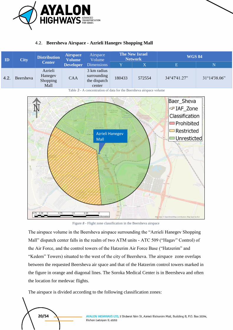
4.2. Beersheva Airspace - Azrieli Hanegev Shopping Mall
ID City Distribution
Center
Airspace
Volume
Developer
Airspace
Volume
Dimensions
The New Israel
Network WGS 84
Y X E N
4.2. Beersheva
Azrieli
Hanegev
Shopping
Mall
CAA
3 km radius
surrounding
the dispatch
center
180433 572554 34°47'41.27” 31°14'38.06”
Table 3 - A concentration of data for the Beersheva airspace volume
The airspace volume in the Beersheva airspace surrounding the “Azrieli Hanegev Shopping
Mall” dispatch center falls in the realm of two ATM units - ATC 509 (“Hagav” Control) of
the Air Force, and the control towers of the Hatzerim Air Force Base (“Hatzerim” and
“Kedem” Towers) situated to the west of the city of Beersheva. The airspace zone overlaps
between the requested Beersheva air space and that of the Hatzerim control towers marked in
the figure in orange and diagonal lines. The Soroka Medical Center is in Beersheva and often
the location for medevac flights.
The airspace is divided according to the following classification zones:
Figure 8 - Flight zone classification in the Beersheva airspace
Azrieli Hanegev
Mall
21/54
Unrestricted Operations
In zones labeled in green it is possible to operate unrestricted up to an altitude of 120 meters
AGL.
Restricted Operations
The area labeled in orange belongs to the control zone of the Hatzerim AFB, activity in the
airspace is subject to a priori coordination and approval of the activity by the Air Force,
including predicted activity times. Activity in this airspace is possible up to a maximum altitude
of 1,500 FT. AMSL. It should be noted that in any case operation in the orange zones is
restricted to the minimum altitude of 40 meters AGL.
Prohibited Operations
There are no areas where activity is prohibited in the Beersheva airspace.
4.2.1. Conditions for operating in the airspace volume
As previously stated, use of this airspace is conditional upon a priori coordination vis-a-vis the
Air Force in the event that the aerial operator wishes to operate within the restricted zone.
Prior to any activity in this airspace volume, coordinated publication is required of the
restrictions noted by AIP Israel, in addition to telephone approval prior to the start of any
activity from the controlling ATM units in the area, i.e., “Hagav” ATC, the “Hatzerim” and
“Kedem” control towers (also in the event of aerial activity from outside the airspace volume
that may overlap the tower’s control zone).
“Soroka” Medical Center is situated within the Beersheva airspace and often serves as the
destination for medevac helicopters that land at the hospital’s heliport. During any helicopter
medical evacuation to/from the above mentioned medical center, aerial activity in the airspace
is required to cease, until removal of the said restriction by “Hagav” ATC.
Due to the complexity of the airspace, and its proximity to various control zones, it is necessary
that aerial operators working in this airspace volume are readily available and capable of
ceasing activity whenever necessary within seconds, in a manner that will not endanger any
aircraft and/or any passerby on the ground.
22/54
4.2.2. Required Contact Numbers
4.2.2.1. ATC 509 (“Hagav”) - TBD
4.2.2.2. Hatzerim Control Tower - TBD
4.2.2.3. Kedem Control Tower - TBD
4.2.2.4. AIS Office – Telephone: 03-9756215/6, Fax: 03-9756219
23/54
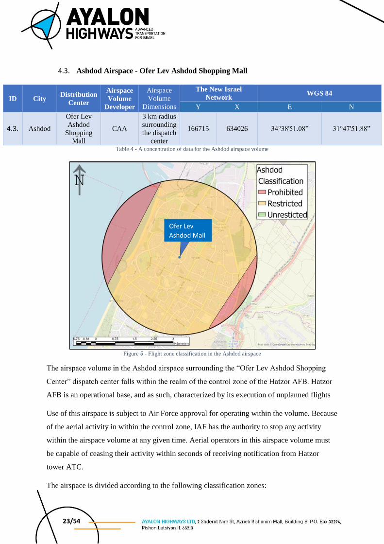
4.3. Ashdod Airspace - Ofer Lev Ashdod Shopping Mall
ID City Distribution
Center
Airspace
Volume
Developer
Airspace
Volume
Dimensions
The New Israel
Network WGS 84
Y X E N
4.3. Ashdod
Ofer Lev
Ashdod
Shopping
Mall
CAA
3 km radius
surrounding
the dispatch
center
166715 634026 34°38'51.08” 31°47'51.88”
Table 4 - A concentration of data for the Ashdod airspace volume
Figure 9 - Flight zone classification in the Ashdod airspace
The airspace volume in the Ashdod airspace surrounding the “Ofer Lev Ashdod Shopping
Center” dispatch center falls within the realm of the control zone of the Hatzor AFB. Hatzor
AFB is an operational base, and as such, characterized by its execution of unplanned flights
Use of this airspace is subject to Air Force approval for operating within the volume. Because
of the aerial activity in within the control zone, IAF has the authority to stop any activity
within the airspace volume at any given time. Aerial operators in this airspace volume must
be capable of ceasing their activity within seconds of receiving notification from Hatzor
tower ATC.
The airspace is divided according to the following classification zones:
Ofer Lev
Ashdod Mall
24/54
Unrestricted Operations
There is no Unrestricted Operations zone in the Ashdod airspace.
Restricted Operations
The activity in the Hatzor control zone, labeled orange, is conditional upon a priori
coordination and approval of the activity by the Air Force, including predicted activity times.
Activity in this airspace is possible up to a maximum altitude of 300 ft/ 91 meters AMSL, due
to the aerial activity within the Hatzor Tower control zone.
It should be noted that in any case operation in the orange zones is restricted to the minimum
altitude of 40 meters AGL.
Prohibited Operations
Adjacent to the area of operations, particularly in its eastern and western portions, are low
altitude VFR routes, which make it impossible to conducted UA aerial activity beneath the
protective zone. Consequently, the eastern and western portions of the airspace volume are
classified as Prohibited Operations zones.
*Nevertheless, aerial activity in the eastern route is possible; however, only during weekends,
and requires that aerial operators seek CAA approval to enable such activity in the eastern
portion of the airspace volume during the days when flight is prohibited in this route.
4.3.1. Conditions for operating in the airspace volume
As previous noted, use of this zone is conditional upon advanced coordination vis-a-vis the Air
Force, and AIP Israel, which will publish the necessary restrictions for operating within the
airspace volume.
In addition, prior to the start of any activity, it is necessary to attain telephone approval from
the ATC unit with responsibility for the control zone, i.e, the Hatzor AFB Control Tower.
“Assuta” Medical Center is situated within the Ashdod airspace and often serves as a
destination for medevac helicopters that land at the hospital’s heliport. During any helicopter
medical evacuation to/from the above-mentioned medical center, aerial activity in the airspace
is required to cease, until removal of the said restriction by the Hatzor AFB Control Tower.
25/54
Due to the complexity of the airspace, and its proximity to various control zones, it is necessary
that aerial operators working in this airspace volume are readily available and capable of
ceasing operation whenever necessary within seconds, in a manner that will not endanger any
aircraft and/or any passerby on the ground.
4.3.2. Required Contact Numbers
4.3.2.1. ATC 509 (“Hagav”) - TBD
4.3.2.2. Hatzor AFB Control Tower - TBD
4.3.2.3. AIS Office – Telephone: 03-9756215/6, Fax: 03-9756219
26/54
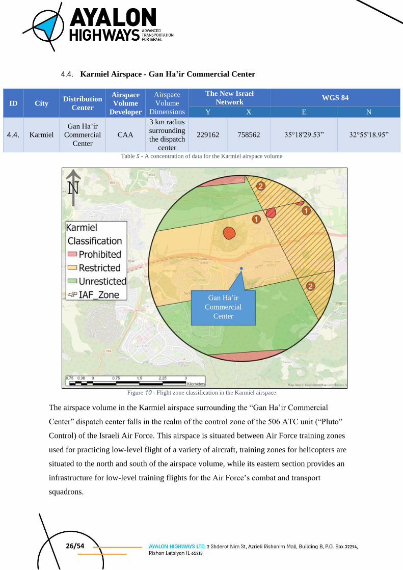
4.4. Karmiel Airspace - Gan Ha’ir Commercial Center
ID City Distribution
Center
Airspace
Volume
Developer
Airspace
Volume
Dimensions
The New Israel
Network WGS 84
Y X E N
4.4. Karmiel Gan Ha’ir
Commercial
Center CAA
3 km radius
surrounding
the dispatch
center
229162 758562 35°18'29.53” 32°55'18.95”
Table 5 - A concentration of data for the Karmiel airspace volume
Figure 10 - Flight zone classification in the Karmiel airspace
The airspace volume in the Karmiel airspace surrounding the “Gan Ha’ir Commercial
Center” dispatch center falls in the realm of the control zone of the 506 ATC unit (“Pluto”
Control) of the Israeli Air Force. This airspace is situated between Air Force training zones
used for practicing low-level flight of a variety of aircraft, training zones for helicopters are
situated to the north and south of the airspace volume, while its eastern section provides an
infrastructure for low-level training flights for the Air Force’s combat and transport
squadrons.
Gan Ha’ir
Commercial
Center
27/54
In addition, there are several civil aviation infrastructures such as VFR routes that cross the
airspace volume at a minimum altitude of 1,700 FT. AMSL, and a sport aviation zone titled
the “Karmiel Bubble” that is active during weekends, and fully overlaps the requested
airspace, under the control zone responsibility of “Pluto” ATC; however, the flight in this
airspace is low-altitude flight without radio contact with the above mentioned ATC.
The airspace is divided according to the following classification zones:
Unrestricted Operations
In the zones classified in green, it is possible to operate unrestricted up to an altitude of 120
meters AGL.
Restricted Operations
Activity within the Air Force training zone marked as previous stated by diagonal lines, is
conditional upon a priori coordination and approval of the said activity by the Air Force,
including predicted activity times, up to a maximum altitude of 2,000 FT. AMSL.
In the areas labeled Zone 1, activity is permitted up to an altitude of 1,200 ft./ 365 meters
AMSL.
In the areas labeled Zone 2, activity is permitted up to an altitude of 120 meters AGL, which
means that the desired area falls within the altitude restrictions, subject to coordination with
the Air Force concerning use of the airspace.
It should be noted that in any case operation in the orange zones is restricted to the minimum
altitude of 40 meters AGL.
Prohibited Operations
The northern and southern sections of the airspace overlap with the Air Force helicopter
training zones that are designated AGL, and therefore flight in these areas is prohibited. In
addition, there are areas where the topography does not enable flight at a minimum altitude of
40 meters AGL without penetrating the protection zone of the VFR route that crosses the
airspace at a minimum altitude of 1,700 FT. AMSL.

28/54
4.4.1. Conditions for operating in the airspace volume
Prior to any activity in this airspace volume, coordinated publication is required of the
restrictions noted by AIP Israel, in addition to telephone approval prior to the start of any
activity from the controlling ATM unit in the area, i.e., “Pluto” ATC. It should be emphasized
that the condition for activity in this airspace during weekends and holidays, its publication of
an aerial closure restricting the area of the “Karmiel Bubble”.
As previously stated, in the event that the aerial operator is interested using the airspace’s
eastern zone, it is necessary to attain a priori approval vis-a-vis the Air Force, including hours
of operation, and a maximum restricted altitude of approximately 2,000 FT. AMSL.
Due to the complexity of the airspace, and its proximity to various control zones, it is necessary
that aerial operators working in this airspace volume are readily available and capable of
ceasing activity whenever necessary within seconds, in a manner that will not endanger any
aircraft and/or any passerby on the ground.
4.4.2. Required Contact Numbers
4.4.2.1. ATC 506 (“Pluto”) - TBD
4.4.2.2. AIS Office – Telephone: 03-9756215/6, Fax: 03-9756219
29/54
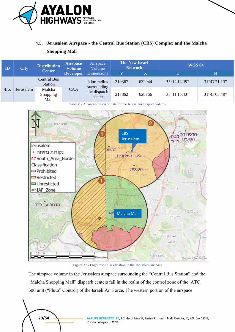
4.5. Jerusalem Airspace - the Central Bus Station (CBS) Complex and the Malcha
Shopping Mall
ID City Distribution
Center
Airspace
Volume
Developer
Airspace
Volume
Dimensions
The New Israel
Network WGS 84
Y X E N
4.5. Jerusalem
Central Bus
Station
CAA
3 km radius
surrounding
the dispatch
center
219367 632944 35°12'12.59” 31°47'21.15”
Malcha
Shopping
Mall 217862 628766 35°11'15.43” 31°45'05.48”
Table 6 - A concentration of data for the Jerusalem airspace volume
The airspace volume in the Jerusalem airspace surrounding the “Central Bus Station” and the
“Malcha Shopping Mall” dispatch centers fall in the realm of the control zone of the ATC
506 unit (“Pluto” Control) of the Israeli Air Force. The western portion of the airspace
Figure 11 - Flight zone classification in the Jerusalem airspace
CBS
Jerusalem
Malcha Mall

30/54
contains an Air Force training zone that is used by combat and transport squadrons to practice
low altitude flying.
In addition, there are several civil aviation infrastructures such as VFR routes that cross the
southern portion of the airspace volume at a minimum altitude of 3,000 FT. AMSL, as well
as multiple heliports in the volume’s northern section, in the radius surrounding the “Central
Bus Station” dispatch center.
The airspace is divided according to the following classification zones:
Unrestricted Operations
In the zones classified in green, it is possible to operate unrestricted up to an altitude of 120
METERS AGL.
Restricted Operations
Activity within the Air Force training zone marked as previous stated by diagonal lines and
labeled Zone 1, is conditional upon a priori coordination and approval of the said activity by
the Air Force, including predicted activity times, up to a maximum altitude of 3,000 FT. AMSL.
In the airspace volume’s northern section labeled Zone 2, aerial activity is permitted up to an
altitude of 120 meters AGL; however, during helicopter landing/takeoff at the heliports within
the area, activity in this area is prohibited, rather in the southern airspace, the border of which
is marked as a broken red line.
It should be noted that in any case operation in the orange zones is restricted to the minimum
altitude of 40 meters AGL.
Prohibited Operations
Flight is prohibited in the eastern section of the airspace surrounding the Old City of Jerusalem
and the Temple Mount. In addition, there are areas where the topography does not enable flight
at a minimum altitude of 40 METERS AGL without penetrating the protection zone of the VFR
route that crosses to the south of the airspace at a minimum altitude of 3,000 FT. AMSL.

31/54
4.5.1. Conditions for operating in the airspace volume
Prior to any activity in this airspace volume, it is first necessary to check for any planning
flights to/from the relevant heliports, and coordinated publication is required of the restrictions
noted by AIP Israel, in addition to telephone approval prior to the start of any activity from the
adjacent ATM unit in the area, i.e., “Hagav” ATC.
As previously stated, in the event that the aerial operator is interested using the airspace’s
western zone, it is necessary to attain a priori approval vis-a-vis the Air Force, including hours
of operation, and a maximum restricted altitude of approximately 3,000 FT. AMSL.
Due to the complexity of the airspace, and its proximity to various control zones, it is necessary
that aerial operators working in this airspace volume are readily available and capable of
ceasing activity whenever necessary within seconds, in a manner that will not endanger any
aircraft and/or any passerby on the ground.
4.5.2. Required Contact Numbers
4.5.2.1. ATC 506 (“Pluto”) - TBD
4.5.2.2. ATC 509 (“Hagav”) - TBD
4.5.2.3. AIS Office – Telephone: 03-9756215/6, Fax: 03-9756219
32/54
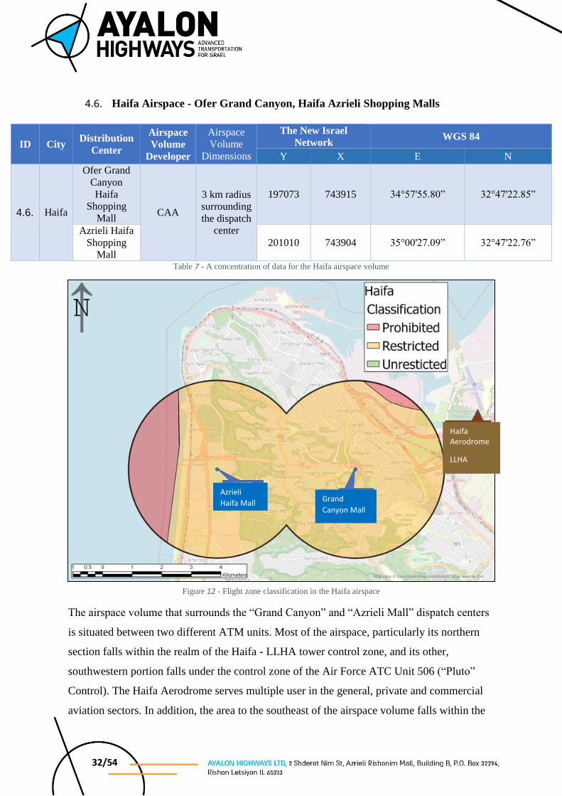
4.6. Haifa Airspace - Ofer Grand Canyon, Haifa Azrieli Shopping Malls
ID City Distribution
Center
Airspace
Volume
Developer
Airspace
Volume
Dimensions
The New Israel
Network WGS 84
Y X E N
4.6. Haifa
Ofer Grand
Canyon
Haifa
Shopping
Mall CAA
3 km radius
surrounding
the dispatch
center
197073 743915 34°57'55.80” 32°47'22.85”
Azrieli Haifa
Shopping
Mall 201010 743904 35°00'27.09” 32°47'22.76”
Table 7 - A concentration of data for the Haifa airspace volume
The airspace volume that surrounds the “Grand Canyon” and “Azrieli Mall” dispatch centers
is situated between two different ATM units. Most of the airspace, particularly its northern
section falls within the realm of the Haifa - LLHA tower control zone, and its other,
southwestern portion falls under the control zone of the Air Force ATC Unit 506 (“Pluto”
Control). The Haifa Aerodrome serves multiple user in the general, private and commercial
aviation sectors. In addition, the area to the southeast of the airspace volume falls within the
Figure 12 - Flight zone classification in the Haifa airspace
Azrieli
Haifa Mall Grand
Canyon Mall
Haifa Aerodrome
LLHA
33/54
control zone of the Ramat David AFB control tower. Use in this airspace is conditional upon
a priori coordination and approval by the Haifa Tower, since most of the airspace volume fall
under the control zone of the Haifa Aerodrome Control Tower.
The airspace is divided according to the following classification zones:
Unrestricted Operations
The Haifa airspace contains no zones where it is possible to operate without restriction up to
120 meters AGL.
Restricted Operations
The lion’s share of the airspace is classified orange, thereby meaning that it is possible to
operate within its borders; however, under certain stipulations. As previously noted, use of the
airspace is conditional upon advance approval of the Haifa Aerodrome Control Tower.
Subsequent to the issuance of the control tower’s approval, operations in the airspace volume
is permitted up to an altitude of 1,500 ft./ 457 meters AMSL. According to this restriction, the
Haifa Aerodrome will be restricted to an altitude of 2,000 FT. AMSL above the areas of the
airspace volume (i.e., 500 ft. above operations).
It should be noted that in any case operation in the orange zones is restricted to the minimum
altitude of 40 meters AGL.
Prohibited Operations
VFR routes at an altitude of 400 FT. AMSL, serving primarily for the approach and departure
of helicopters to/from the Haifa Aerodrome are located in the northeastern and the western
sections of the airspace volume. The low altitude of the route does not allow for aerial activity
at the separation require beneath it, and therefore the zone is classified at prohibited for flight.
4.6.1. Conditions for operating in the airspace volume
Prior to any activity in this airspace volume, it is necessary to attain the approval of the ATM
units surrounding the zone, i.e., ATC “Pluto”, and LLHA Tower. Furthermore, aerial activity
must be coordinated a priori, according to the times defined in AIP Israel.
Due to the complexity of the airspace, and its proximity to various control zones, it is
necessary that aerial operators working in this airspace volume are readily available and
34/54
capable of ceasing operation whenever necessary within seconds, in a manner that will not
endanger any aircraft and/or any passerby on the ground.
4.6.2. Contact details
4.6.2.1. ATC 506 (“Pluto”) - TBD
4.6.2.2. Haifa Tower - Telephone: 04-8476120, Fax: 04-8476122
4.6.2.3. AIS Office – Telephone: 03-9756215/6, Fax: 03-9756219

35/54
4.7. Eilat Airspace - Mall HaYam Shopping Mall
ID City Distribution
Center
Airspace
Volume
Developer
Airspace
Volume
Dimensions
The New Israel
Network WGS 84
Y X E N
4.7. Eilat Mall HaYam
Shopping
Mall CAA
3 km radius
surrounding
the dispatch
center
195204 384748 34°57'15.17” 29° 33'00.91”
Table 8 - A concentration of Eilat airspace data
The airspace volume in the vicinity of the “Mall HaYam Shopping Mall” dispatch center falls
within the control zone of the Eilat Control Tower (the Ilan and Assaf Ramon Aerodrome).
Above the Eilat airspace there is a VFR route that during the week serves the general aviation
sector, and in addition, the sports aviation sector, during the weekends. Minimum flight
Figure 13 - Flight zone classification in the Eilat airspace
Mall HaYam
Mall
36/54
altitude during the week is 2,500 FT. AMSL; however, during weekends, due to the sports
aviation, minimum flight altitude drops to 700 FT. AMSL.
The Josephtal Medical Center is in Eilat and often the location for medevac flights.
In addition, there is an active sky-diving area in the eastern portion of the city.
The airspace is divided according to the following classification zones:
Unrestricted Operations
In most of the Eilat airspace, in those zones labeled in green it is possible to operate unrestricted
up to an altitude of 120 meters AGL.
Restricted Operations
The zone classified orange falls beneath the VFR route leading to/from the city. During the
week this area is unrestricted, and it is possible to operate up to an altitude of 120 meters AGL;
however, on weekends, the activity in this zone is restricted to a maximum altitude of 200 ft./
60 meters AMSL.
It should be noted that in any case operation in the orange zones is restricted to the minimum
altitude of 40 meters AGL.
Prohibited Operations
Due to the proximity to the international border, no flights are to be conducted more than 300
m from the shoreline. In addition, no flights will be conducted in the skydiving drop zone. The
areas prohibited for flight are marked in red.
4.7.1. Conditions for operating in the airspace volume
Prior to any activity in this airspace volume, it is necessary to attain the approval of the ATM
unit surrounding the zone, i.e., LLER Tower (Eilat - Ramon). Furthermore, aerial activity must
be coordinated a priori, according to the times defined in AIP Israel.
“Josephtal” Medical Center is situated within the Eilat airspace and often serves as a destination
for medevac helicopters that land at the hospital’s heliport. During any helicopter medical
evacuation to/from the above mentioned medical center, aerial activity in the airspace is
required to cease, until removal of the said restriction by “Hagav” ATC/Ramon Tower.
37/54
Due to the complexity of the airspace, and its proximity to various control zones, it is necessary
that aerial operators working in this airspace volume are readily available and capable of
ceasing operation whenever necessary within seconds, in a manner that will not endanger any
aircraft and/or any passerby on the ground.
4.7.2. Contact details
4.7.2.1. ATC 509 (“Hagav”) - TBD
4.7.2.2. Ramon Tower (Eilat) - 08-9553666
4.7.2.3. AIS Office – Telephone: 03-9756215/6, Fax: 03-9756219
38/54
4.8. Sharonim Shopping Mall - Hod Hasharon
ID City Distribution
Center
Airspace
Volume
Developer
Airspace
Volume
Dimensions
The New Israel
Network WGS 84
Y X E N
4.8. Hod
Hasharon
Sharonim
Shopping
Mall Flytrex
5.5 km X
5.5 km 190971 671084 34°54' 9.21” 32°7' 58.08”
Table 9 - A concentration of data for the Sharonim Shopping Mall, Hod Hasharon airspace volume
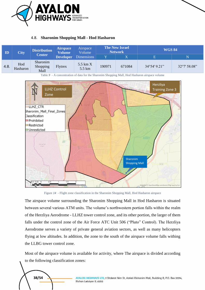
Figure 14 - Flight zone classification in the Sharonim Shopping Mall, Hod Hasharon airspace
The airspace volume surrounding the Sharonim Shopping Mall in Hod Hasharon is situated
between several various ATM units. The volume’s northwestern portion falls within the realm
of the Herzliya Aerodrome - LLHZ tower control zone, and its other portion, the larger of them
falls under the control zone of the Air Force ATC Unit 506 (“Pluto” Control). The Herzliya
Aerodrome serves a variety of private general aviation sectors, as well as many helicopters
flying at low altitudes. In addition, the zone to the south of the airspace volume falls withing
the LLBG tower control zone.
Most of the airspace volume is available for activity, where The airspace is divided according
to the following classification zones:
Sharonim
Shopping Mall
LLHZ Control
Zone
Herzliya
Training Zone 3

39/54
Unrestricted Operations
In the zones classified in green, it is possible to operate unrestricted up to an altitude of 120
meters AGL.
Restricted Operations
In zones classified orange it is possible to operate under certain stipulations. In the orange zone
that is situated in the volume’s northeastern section, there is an overlap with Training Zone 3
for light aviation that fall under the control of the Herzliya Aerodrome Tower. Minimum flight
altitude in the area is 1,000 FT. AMSL, and therefore maximum flight altitude for UA
operations in the volume under the zone is 500 ft./139 meters AMSL.
In the orange zone in the volume’s center it is only possible to operate up to an altitude of 91
MASL due to CVFR routes crossing at a minimal altitude of 800 FT. AMSL above the airspace
volume. It should be noted that in any case operation in the orange zones is restricted to the
minimum altitude of 40 meters AGL.
Prohibited Operations
In the northern section of the airspace volume, the higher ground levels, do not enable flight at
the minimum altitude of 40 meters AGL without penetrating the protective zones defined for
the CVFR routes above the volume, and therefore these areas are classified as red zones where
flight is prohibited.
In addition, in the volume’s southwestern portion, there is an approach/departure route at an
altitude of 400/600 FT. AMSL that serves primarily helicopters to/from the Herzliya
Aerodrome. The low altitude of the route does not allow for aerial activity at the separation
require beneath it, and therefore the zone is classified at prohibited for flight.

40/54
4.8.1. Conditions for operating in the airspace volume
Prior to any activity in this airspace volume, it is necessary to attain the approval of the ATM
units surrounding the zone, i.e., the ATM units “Pluto”, LLBG Tower, and LLHZ Tower.
Furthermore, aerial activity must be coordinated a priori, according to the times defined in AIP
Israel.
Due to the complexity of the airspace, and its proximity to various control zones, it is necessary
that aerial operators working in this airspace volume are readily available and capable of
ceasing operation whenever necessary within seconds, in a manner that will not endanger any
aircraft and/or any passerby on the ground.
4.8.2. Contact details
4.8.2.1. ATC 506 (“Pluto”) - TBD
4.8.2.2. Herzliya Tower – 09-9719554, 09-9719559, Fax: 09-9719574
4.8.2.3. Ben Gurion Tower – 03-9758110, 03-9758666
4.8.2.4. AIS Office – Telephone: 03-9756215/6, Fax: 03-9756219
41/54
4.9. Kadima-Tzoran Industrial Zone, Kadima
ID City Distribution
Center
Airspace
Volume
Developer
Airspace
Volume
Dimensions
The New Israel
Network WGS 84
Y X E N
4.9. Kadima
Kadima-
Tzoran
Industrial
Zone
Flytrex 5.1 km X
4.3 km 192696 686976 34°55'13.43” 32°16'34.15”
Table 10 - A concentration of data for the Kadima airspace volume
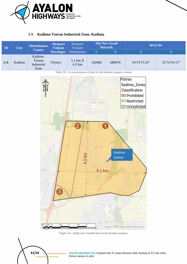
Figure 15 - Flight zone classification in the Kadima airspace
Kadima
Center
42/54
The airspace volume that surrounds the “Kadima Center” in Kadima is situated between two
different ATM units. Above the area of the airspace is Training Zone 9 for light aviation, which
is under the control of the Herzliya Aerodrome. Outside the boundary of Zone 9, the airspace
falls under the control of ATC 506 (“Pluto” Control) of the IAF.
In full overlap with the operational airspace, is a sport aviation zone known as the “Southern
Hasharon Bubble”, which although it falls under the control of “Pluto” ATC, because of the
low level flying in this airspace, it is without radio communications with the ATM unit. As
previously noted, to the east of Route 4 is Training Zone 9 for light aviation, which belongs to
the Herzliya tower. Flight in this zone is conducted at a minimum altitude of 500 FEET AGL.
Division of utilization times in the zone, as well as its ATM fall under responsibility of the
Herzliya tower.
Utilization in the Kadima airspace is subject to the establishment of an aerial closure that
restricts the area of the Southern Hasharon Bubble and limits the minimum flight altitude
in the Herzliya Training Zones to a minimum altitude of 1,000 FT. AMSL to enable UA
operations in the desired area.
In addition, west of the zone along Route 4, VFR route crosses serving aerial traffic to/from
the Herzliya Aerodrome. The minimum flight altitude in the route varies, e.g., north to the Bnei
Dror Junction the minimum altitude is 1,500 FT. AMSL, while south of Bnei Dror Junction the
route’s minimum altitude is 800 FT. AMSL.
The airspace is divided according to the following classification zones:
Unrestricted Operations
The Kadima airspace contains no zones where it is possible to operate up to 120 METERS
AGL without restriction.
Restricted Operations
In the zones classified orange it is possible to operate under certain stipulations:
The orange zone labeled Zone 1 falls under the Training Zones of Herzliya, serving General
Aviation type aircraft. As previously mentioned, the condition for operation in the Kadima
airspace is a restriction of the areas to a minimum altitude of 1,000 FT. AMSL, which enables
UA operations up to an altitude of 500 ft./152 meters AMSL.
43/54
The orange zone labeled Zone 2 falls under a VFR route at a minimum altitude of 1,500 FT.
AMSL, which enables UA operations up to an altitude of 1,000 ft./304 meters AMSL.
The orange zone labeled Zone 32 falls under a VFR route at a minimum altitude of 800 FT.
AMSL, which enables UA operations up to an altitude of 300 ft./91 meters AMSL.
It should be noted that in any case operation in the orange zones is restricted to the minimum
altitude of 40 meters AGL.
Prohibited Operations
There are no areas where activity is prohibited in the Kadima airspace.
4.9.1. Conditions for operating in the airspace volume
As previously noted, use in this zone is subject to the restrictions of the aerial infrastructures
such as “The South Hasharon Bubble” and the Herzliya Training Zone. Prior to any activity in
this airspace volume, coordinated publication is required of the restrictions noted by AIP Israel,
in addition to telephone approval prior to the start of any activity opposite the controlling ATM
units in the area, i.e., “Pluto” ATC and the Herzliya Aerodrome.
Due to the complexity of the airspace, and its proximity to various control zones, it is necessary
that aerial operators working in this airspace volume are readily available and capable of
ceasing operation whenever necessary within seconds, in a manner that will not endanger any
aircraft and/or any passerby on the ground.
4.9.2. Contact details
4.9.2.1. ATC 506 (“Pluto”) - TBD
4.9.2.2. Herzliya Tower – 09-9719554, 09-9719559, Fax: 09-9719574
4.9.2.3. AIS Office – Telephone: 03-9756215/6, Fax: 03-9756219

44/54
4.10. M Haderech Shopping Mall - Beit Yanai
ID City Distribution
Center
Airspace
Volume
Developer
Airspace
Volume
Dimensions
The New Israel
Network WGS 84
Y X E N
4.10. Beit
Yanai
M Haderech
Shopping
Mall Flytrex
1.9 km X
4.3 km 187717 698883 34°52'01.72” 32°23'00.19”
Table 11 - A concentration of data for the M Haderech airspace volume
Figure 16 - Flight zone classification in the M Haderech airspace
M Haderech
Shopping Mall
45/54
The airspace volume surrounding the “M Haderech Shopping Mall” in Beit Yanai, falls under
the control zone of the ATM unit ATC 506 (“Pluto” Control) of the IAF.
In full overlap with the operational airspace, is a sport aviation zone known as the “Southern
Hasharon Bubble”, which although it falls under the control of “Pluto” ATC, because of the
low level flying in this airspace, it is without radio communications with the ATM unit. In
addition, above the M Haderech airspace is Training Zone 12 for light aviation, which is under
the control of the Herzliya Aerodrome. Flight in this zone is conducted at a minimum altitude
of 500 FEET AGL. Division of utilization times fall under the Herzliya tower, while ATM is
the responsibility of “Pluto” ATC.
Utilization in the M Haderech airspace is conditional upon the establishment of an aerial
closure that restricts the area of the Southern Hasharon Bubble and limits the minimum
flight altitude in the Herzliya Training Zones to a minimum altitude of 1,000 FT. AMSL
to enable UA operations in the desired area.
The airspace is divided according to the following classification zones:
Unrestricted Operations
The M Haderech airspace contains no zones where it is possible to operate up to 120 METERS
AGL without restriction.
Restricted Operations
In zones classified orange it is possible to operate under certain stipulations. The orange zone
falls under the Training Zones of Herzliya, serving General Aviation type aircraft. As
previously mentioned, the condition for operation in the Kadima airspace is a restriction of the
areas to a minimum altitude of 1,000 FT. AMSL, which enables UA operations up to an altitude
of 500 ft./152 meters AMSL.
Prohibited Operations
There are no areas where activity is prohibited in the M Haderech airspace.
46/54
4.10.1. Conditions for operating in the airspace volume
As previously noted, use in this zone is subject to the restrictions of the aerial infrastructures
such as “The South Hasharon Bubble” and the Herzliya Training Zone. Prior to any activity in
this airspace volume, coordinated publication is required of the restrictions noted by AIP Israel,
in addition to telephone approval prior to the start of any activity from the controlling ATM
unit in the area, i.e., “Pluto” ATC, and the ATM unit responsible for the division of the
resource, i.e., the Herzliya Aerodrome Control Tower.
Due to the complexity of the airspace, and its proximity to various control zones, it is necessary
that aerial operators working in this airspace volume are readily available and capable of
ceasing operation whenever necessary within seconds, in a manner that will not endanger any
aircraft and/or any passerby on the ground.
4.10.2. Contact details
4.10.2.1. ATC 506 (“Pluto”) - TBD
4.10.2.2. Herzliya Tower – 09-9719554, 09-9719559, Fax: 09-9719574
4.10.2.3. AIS Office – Telephone: 03-9756215/6, Fax: 03-9756219
47/54
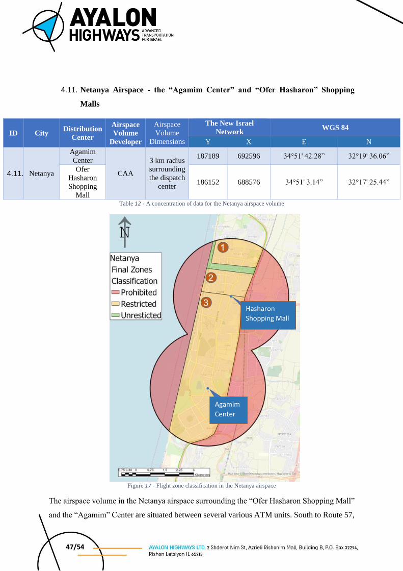
4.11. Netanya Airspace - the “Agamim Center” and “Ofer Hasharon” Shopping
Malls
ID City Distribution
Center
Airspace
Volume
Developer
Airspace
Volume
Dimensions
The New Israel
Network WGS 84
Y X E N
4.11. Netanya
Agamim
Center
CAA
3 km radius
surrounding
the dispatch
center
187189 692596 34°51' 42.28” 32°19' 36.06”
Ofer
Hasharon
Shopping
Mall
186152 688576 34°51' 3.14” 32°17' 25.44”
Table 12 - A concentration of data for the Netanya airspace volume
Figure 17 - Flight zone classification in the Netanya airspace
The airspace volume in the Netanya airspace surrounding the “Ofer Hasharon Shopping Mall”
and the “Agamim” Center are situated between several various ATM units. South to Route 57,
Hasharon
Shopping Mall
Agamim
Center

48/54
above land, is the Number 8 Light Aviation Training Zone, under the control of the Herzliya
Aerodrome Control Tower. The other portion of the airspace volume falls under the control of
ATC 506 (“Pluto” Control) of the IAF. It should be noted that west of Route 2, there is a sports
aviation zone, which fall under the control of “Pluto” ATC; however, flight in this airspace is
at a low altitude and without radio communications with the ATM unit.
The Laniado Medical Center is in Netanya and often the location for medevac flights.
Most of the airspace volume is available for activity, where The airspace is divided according
to the following classification zones:
Unrestricted Operations
In the zones classified in green, it is possible to operate unrestricted up to an altitude of 120
meters AGL.
Restricted Operations
In zones classified orange it is possible to operate under certain stipulations. The orange zones
labeled as Zones 1 and 3 fall under the Training Zones 12 and 8 for light aviation (respectively).
As previously noted, south to Route 57 the training zone are controlled by the Herzliya
Aerodrome, and northward the training zones are controlled by “Pluto” ATC. Minimum flight
altitude in these areas is 1,000 FT. AMSL, and therefore maximum flight altitude for UA
operations in the volume under the zone is 500 ft./139 meters AMSL.
In the orange zone labeled Zone 2 it is possible to operate up to an altitude of 1,000 ft./304
meters AMSL due to CVFR routes crossing at a minimal altitude of 1,500 FT. AMSL above
the airspace volume.
It should be noted that in any case operation in the orange zones is restricted to the minimum
altitude of 40 meters AGL.
49/54
Prohibited Operations
In the volume’s eastern portion, each of Route 2, there is VFR zone (uncontrolled) that serves
the sports aviation sector. The zone is defined by Route 2, and aircraft operations are conducted
from ground level up to an altitude of 700 FT. AMSL, and therefore the area is classified red
and flight prohibited.
In addition, in the volume’s western portion, a VFR route serves north/southbound helicopter
traffic along the coastal plain at a minimum altitude of 400 FT. AMSL. The route’s center is
located 1 km west of the shoreline, such that the width of the route’s protective zone has no
impact on the airspace east of the shoreline. The low altitude of the route does not allow for
aerial activity at the separation require beneath it, and therefore the zone is classified at
prohibited for flight.
4.11.1. Conditions for operating in the airspace volume
Prior to any activity in this airspace volume, it is necessary to attain the approval of the ATM
units surrounding the zone, i.e., the ATM units “Pluto”, and LLHZ Tower.
Furthermore, aerial activity must be coordinated a priori, according to the times defined in AIP
Israel.
It should also be noted that the “Laniado” Medical Center is situated within the Netanya
airspace and often serves as a destination for medevac helicopters that land at the hospital’s
heliport. During any helicopter medical evacuation to/from the above mentioned medical
center, aerial activity in the airspace is required to cease, until removal of the said restriction
by “Pluto” ATC.
Due to the complexity of the airspace, and its proximity to various control zones, it is necessary
that aerial operators working in this airspace volume are readily available and capable of
ceasing operation whenever necessary within seconds, in a manner that will not endanger any
aircraft and/or any passerby on the ground.

50/54
4.11.2. Required Contact Numbers
4.11.2.1. ATC 506 (“Pluto”) - TBD
4.11.2.2. Herzliya Tower – 09-9719554, 09-9719559, Fax: 09-9719574
4.11.2.3. AIS Office – Telephone: 03-9756215/6, Fax: 03-9756219
51/54
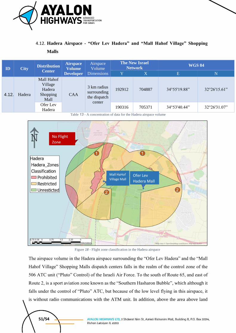
4.12. Hadera Airspace - “Ofer Lev Hadera” and “Mall Hahof Village” Shopping
Malls
ID City Distribution
Center
Airspace
Volume
Developer
Airspace
Volume
Dimensions
The New Israel
Network WGS 84
Y X E N
4.12. Hadera
Mall Hahof
Village
Hadera
Shopping
Mall CAA
3 km radius
surrounding
the dispatch
center
192912 704887 34°55'19.88” 32°26'15.61”
Ofer Lev
Hadera 190316 705371 34°53'40.44” 32°26'31.07”
Table 13 - A concentration of data for the Hadera airspace volume
The airspace volume in the Hadera airspace surrounding the “Ofer Lev Hadera” and the “Mall
Hahof Village” Shopping Malls dispatch centers falls in the realm of the control zone of the
506 ATC unit (“Pluto” Control) of the Israeli Air Force. To the south of Route 65, and east of
Route 2, is a sport aviation zone known as the “Southern Hasharon Bubble”, which although it
falls under the control of “Pluto” ATC, but because of the low level flying in this airspace, it
is without radio communications with the ATM unit. In addition, above the area above land
Figure 18 - Flight zone classification in the Hadera airspace
No Flight
Zone
Ofer Lev
Hadera Mall
Mall HaHof
Village Mall
52/54
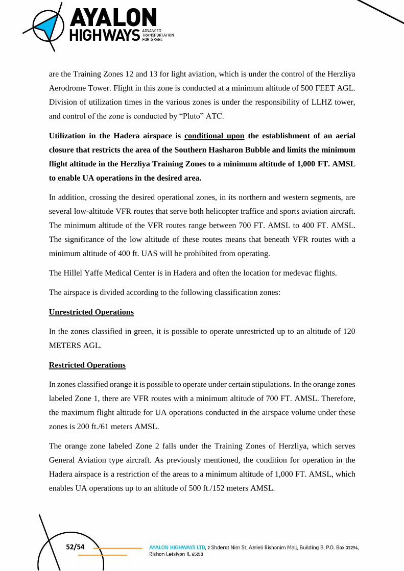
are the Training Zones 12 and 13 for light aviation, which is under the control of the Herzliya
Aerodrome Tower. Flight in this zone is conducted at a minimum altitude of 500 FEET AGL.
Division of utilization times in the various zones is under the responsibility of LLHZ tower,
and control of the zone is conducted by “Pluto” ATC.
Utilization in the Hadera airspace is conditional upon the establishment of an aerial
closure that restricts the area of the Southern Hasharon Bubble and limits the minimum
flight altitude in the Herzliya Training Zones to a minimum altitude of 1,000 FT. AMSL
to enable UA operations in the desired area.
In addition, crossing the desired operational zones, in its northern and western segments, are
several low-altitude VFR routes that serve both helicopter traffice and sports aviation aircraft.
The minimum altitude of the VFR routes range between 700 FT. AMSL to 400 FT. AMSL.
The significance of the low altitude of these routes means that beneath VFR routes with a
minimum altitude of 400 ft. UAS will be prohibited from operating.
The Hillel Yaffe Medical Center is in Hadera and often the location for medevac flights.
The airspace is divided according to the following classification zones:
Unrestricted Operations
In the zones classified in green, it is possible to operate unrestricted up to an altitude of 120
METERS AGL.
Restricted Operations
In zones classified orange it is possible to operate under certain stipulations. In the orange zones
labeled Zone 1, there are VFR routes with a minimum altitude of 700 FT. AMSL. Therefore,
the maximum flight altitude for UA operations conducted in the airspace volume under these
zones is 200 ft./61 meters AMSL.
The orange zone labeled Zone 2 falls under the Training Zones of Herzliya, which serves
General Aviation type aircraft. As previously mentioned, the condition for operation in the
Hadera airspace is a restriction of the areas to a minimum altitude of 1,000 FT. AMSL, which
enables UA operations up to an altitude of 500 ft./152 meters AMSL.
53/54
It should be noted that in any case operation in the orange zones is restricted to the minimum
altitude of 40 meters AGL.
Prohibited Operations
The eastern and western edges of the Hadera airspace contain VFR routes at an altitude of 400
FT. AMSL, which beneath this level prohibits UA operation. In addition, in the center of the
airspace volume, along Route 2, there is a ridge that prohibits UA operation at a maximum
altitude of 61 MASL, while maintaining a minimum altitude of 40 meters AGL.
In its northwestern portion of the area, there is an area that is a no-flight zone5, from ground
level to an altitude of 2,000 FT. AMSL.
5AIP Israel, Section ENR 5.1, Prohibited, Restricted and Danger Areas LLP07

54/54
4.12.1. Conditions for operating in the airspace volume
As previously noted, use in this zone is subject to the restrictions of the aerial infrastructures
such as “The South Hasharon Bubble” and the Herzliya Training Zone. Prior to any activity in
this airspace volume, coordinated publication is required of the restrictions noted by AIP Israel,
in addition to telephone approval prior to the start of any activity from the controlling ATM
unit in the area, i.e., “Pluto” ATC. In addition it is necessary to update the LLHZ Control Tower
of the restrictions entering into force.
It should also be noted that the “Hillel Yaffe” Medical Center is situated within the Hadera
airspace and often serves as a destination for medevac helicopters that land at the hospital’s
heliport. During any helicopter medical evacuation to/from the above mentioned medical
center, aerial activity in the airspace is required to cease, until removal of the said restriction
by “Pluto” ATC.
Due to the complexity of the airspace, and its proximity to various control zones, it is necessary
that aerial operators working in this airspace volume are readily available and capable of
ceasing operation whenever necessary within seconds, in a manner that will not endanger any
aircraft and/or any passerby on the ground.
4.12.2. Required Contact Numbers
4.12.2.1. ATC 506 (“Pluto”) - TBD
4.12.2.2. Herzliya Tower – 09-9719554, 09-9719559, Fax: 09-9719574
4.12.2.3. AIS Office – Telephone: 03-9756215/6, Fax: 03-9756219


![Agl Carbon Article[1]](https://img.pdfslide.us/doc/110x75/553318fb5503464f7d8b47f4/agl-carbon-article1.jpg)