Embed Size (px)
Citation preview

AIRS Atmospheric Infrared Sounder
AIRS Version 4.0 Released Files Description
March 2005 Version 1.0
Jet Propulsion Laboratory California Institute of Technology Pasadena, California JPL D-31502

ii
This page intentionally left blank.
iii
AIRS Atmospheric Infrared Sounder
AIRS Version 4.0 Released Files Description
Prepared By: Adrienne Harris, Technical Writer AIRS Science Processing System Approved By: Evan M. Manning, System Engineer AIRS Science Processing System Steven Z. Friedman, Project Element Manager AIRS Science Processing System
Jet Propulsion Laboratory California Institute of Technology Pasadena, California JPL D-31502

iv
This page intentionally left blank.

v
Document Change Log
Date Version Number Reason for Change March 2005 Initial Release

vi
This page intentionally left blank.
CONTENTS
1 INTRODUCTION.....................................................................................................................................................1

vii
1.1 PURPOSE .............................................................................................................................................................1 1.2 PRODUCT OVERVIEW.........................................................................................................................................1 1.3 APPLICABLE DOCUMENTS .................................................................................................................................2 1.4 ACRONYMNS ......................................................................................................................................................3
APPENDIX A1. SINGLE-SWATH FIXED-FORMAT PRODUCT INTERFACE SPECIFICATIONS ............5
A1-1. L1B AIRS SCIENCE INTERFACE SPECIFICATION....................................................................................7 Dimensions ................................................................................................................................................................7 Geolocation Fields....................................................................................................................................................8 Attributes ....................................................................................................................................................................8 Per-Granule Data Fields .......................................................................................................................................13 Along-Track Data Fields .......................................................................................................................................16 Full Swath Data Fields ..........................................................................................................................................20 Special AIRS Types ...............................................................................................................................................23
A1-2. L1B AIRS QA INTERFACE SPECIFICATION..............................................................................................26 Dimensions ..............................................................................................................................................................26 Geolocation Fields..................................................................................................................................................27 Attributes ..................................................................................................................................................................27 Per-Granule Data Fields .......................................................................................................................................32 Along-Track Data Fields .......................................................................................................................................35 Full Swath Data Fields ..........................................................................................................................................39 Special AIRS Types ...............................................................................................................................................42
A1-3. L1B VISIBLE/NIR SCIENCE INTERFACE SPECIFICATION..................................................................45 Dimensions ..............................................................................................................................................................45 Geolocation Fields..................................................................................................................................................46 Attributes ..................................................................................................................................................................46 Per-Granule Data Fields .......................................................................................................................................50 Along-Track Data Fields .......................................................................................................................................51 Full Swath Data Fields ..........................................................................................................................................54 Special AIRS Types ...............................................................................................................................................58
A1-4. L1B VISIBLE/NIR QA INTERFACE SPECIFICATION ..............................................................................61 Dimensions ..............................................................................................................................................................61 Geolocation Fields..................................................................................................................................................62 Attributes ..................................................................................................................................................................62 Per-Granule Data Fields .......................................................................................................................................65 Along-Track Data Fields .......................................................................................................................................66 Full Swath Data Fields ..........................................................................................................................................69 Special AIRS Types ...............................................................................................................................................72
A1-5. L1B AMSU-A INTERFACE SPECIFICATION...............................................................................................75 Dimensions ..............................................................................................................................................................75 Geolocation Fields..................................................................................................................................................76 Attributes ..................................................................................................................................................................76 Per-Granule Data Fields .......................................................................................................................................81 Along-Track Data Fields .......................................................................................................................................82 Full Swath Data Fields ..........................................................................................................................................87 Special AIRS Types ...............................................................................................................................................90
A1-6. L1B HSB INTERFACE SPECIFICATION.......................................................................................................93 Dimensions ..............................................................................................................................................................93
viii
Geolocation Fields..................................................................................................................................................94 Attributes ..................................................................................................................................................................94 Per-Granule Data Fields .......................................................................................................................................98 Along-Track Data Fields .......................................................................................................................................99 Full Swath Data Fields ........................................................................................................................................103 Special AIRS Types .............................................................................................................................................106
A1-7. L2 STANDARD ATMOSPHERIC/SURFACE PRODUCT INTERFACE SPECIFICATION..............109 Dimensions ............................................................................................................................................................109 Geolocation Fields................................................................................................................................................110 Attributes ................................................................................................................................................................110 Per-Granule Data Fields .....................................................................................................................................114 Along-Track Data Fields .....................................................................................................................................114 Full Swath Data Fields ........................................................................................................................................117
A1-8. L2 STANDARD CLOUD-CLEARED RADIANCE PRODUCT INTERFACE SPECIFICATION......129 Dimensions ............................................................................................................................................................129 Geolocation Fields................................................................................................................................................129 Attributes ................................................................................................................................................................130 Per-Granule Data Fields .....................................................................................................................................133 Along-Track Data Fields .....................................................................................................................................134 Full Swath Data Fields ........................................................................................................................................137
A1-9. L2 SUPPORT ATMOSPHERIC/SURFACE PRODUCT INTERFACE SPECIFICATION..................145 Dimensions ............................................................................................................................................................145 Geolocation Fields................................................................................................................................................147 Attributes ................................................................................................................................................................147 Per-Granule Data Fields .....................................................................................................................................151 Along-Track Data Fields .....................................................................................................................................151 Full Swath Data Fields ........................................................................................................................................154 Special AIRS Types .............................................................................................................................................179
APPENDIX A2. SUMMARY BROWSE PRODUCT INTERFACE SPECIFICATIONS .................................182
APPENDIX A3. LEVEL 3 STANDARD PRODUCT INTERFACE SPECIFICATION....................................186 Geolocation Fields ..................................................................................................................................................186 Attributes..................................................................................................................................................................187 Ascending and Descending Grid Fields ................................................................................................................188 Microwave-only Ascending and Descending Grid Fields ....................................................................................192
APPENDIX B. AIRS FILENAMES AND LOCAL GRANULE ID (LGID) CONVENTION ...........................195
APPENDIX C-1. AIRS PRODUCTS ...........................................................................................................................199
APPENDIX C-2. AIRS DYNAMIC INPUTS .............................................................................................................201
APPENDIX C-3. AIRS STATIC ANCILLARY INPUTS ........................................................................................205
LIST OF TABLES TABLE 1. PRODUCT AND QA FILE TYPES..............................................................................................................1

ix

x
This page intentionally left blank.

1
1 Introduction
1.1 Purpose This document describes the released product files for the Version 4.0.9.0 (V4.0.9.0) delivery of the AIRS Science Processing System (ASPS). These products incorporate data from the AIRS, AMSU-A (AMSU-A1 + AMSU-A2) and HSB instruments.
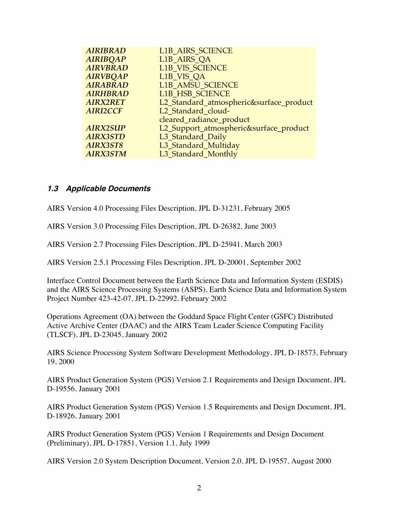
1.2 Product Overview Level 1B science data is calibrated instrument measurements in physical units. Data from the AIRS instrument is divided into separate products: AIRIBRAD has infrared data, while AIRVBRAD has Vis/NIR data. The corresponding AIRIBQAP and AIRVBQAP QA subset files exclude radiances and other large fields to deliver quality information in a compact format. AIRS IR and Vis/NIR radiances are in radiance units, while MW instrument data AIRABRAD and AIRHBRAD are in brightness temperature units. In Level 2 atmospheric and surface quantities are estimated from the Level 1B data. Level 2 products are cloud-cleared radiances (AIRI2CCF) and atmospheric parameters (AIRX2RET and AIRX2SUP). The standard retrieval product AIRX2RET is designed for the general user, while the support product (ARIX2SUP) contains interim and experimental portions intended for use by the AIRS team and others willing to make a significant investment of time in understanding the product. Each Level 1B and Level 2 science file type contains data from 6 minutes of observations in HDF-EOS Swath format. Level 3 files grid data from AIRX2RET standard retrieval product in daily (AIRX3STD), eight-day (AIRX3ST8), and monthly (AIRX3STM) HDF-EOS Grid products. The Daily Browse summary global images (AIRxxDBR) of Level 1B or Level 2 products are useful for a quick look at data and as an aide to ordering. AIRS products are archived at the GSFC DAAC archive. These product formats are defined in the product interface specifications, provided in Appendix A. The basic product and QA file types are shown in Table 1.
Table 1. Product and QA File Types ESDT Shortname Mnemonic Name
2
AIRIBRAD L1B_AIRS_SCIENCE AIRIBQAP L1B_AIRS_QA AIRVBRAD L1B_VIS_SCIENCE AIRVBQAP L1B_VIS_QA AIRABRAD L1B_AMSU_SCIENCE AIRHBRAD L1B_HSB_SCIENCE AIRX2RET L2_Standard_atmospheric&surface_product AIRI2CCF L2_Standard_cloud-
cleared_radiance_product AIRX2SUP L2_Support_atmospheric&surface_product AIRX3STD L3_Standard_Daily AIRX3ST8 L3_Standard_Multiday AIRX3STM L3_Standard_Monthly
1.3 Applicable Documents AIRS Version 4.0 Processing Files Description, JPL D-31231, February 2005 AIRS Version 3.0 Processing Files Description, JPL D-26382, June 2003 AIRS Version 2.7 Processing Files Description, JPL D-25941, March 2003 AIRS Version 2.5.1 Processing Files Description, JPL D-20001, September 2002 Interface Control Document between the Earth Science Data and Information System (ESDIS) and the AIRS Science Processing Systems (ASPS), Earth Science Data and Information System Project Number 423-42-07, JPL D-22992, February 2002 Operations Agreement (OA) between the Goddard Space Flight Center (GSFC) Distributed Active Archive Center (DAAC) and the AIRS Team Leader Science Computing Facility (TLSCF), JPL D-23045, January 2002 AIRS Science Processing System Software Development Methodology, JPL D-18573, February 19, 2000 AIRS Product Generation System (PGS) Version 2.1 Requirements and Design Document, JPL D-19556, January 2001 AIRS Product Generation System (PGS) Version 1.5 Requirements and Design Document, JPL D-18926, January 2001 AIRS Product Generation System (PGS) Version 1 Requirements and Design Document (Preliminary), JPL D-17851, Version 1.1, July 1999 AIRS Version 2.0 System Description Document, Version 2.0, JPL D-19557, August 2000

3
AIRS Science Software Integration and Test Procedures and Agreement with the Goddard Distributed Active Archive Center, JPL D-16791, Version 3, Revision 2.0, June 1, 2000 AIRS Product Generation System (PGS) Prototype 8 Requirements and Design Document (Preliminary), JPL D-16451, Version 1.0, December 1998 AIRS Data Processing and Instrument Operations (DPIO) Software Requirements Document, JPL D-16785, Version 1.0, April 3, 1998
1.4 Acronymns AIRS Atmospheric Infrared Sounder AMSU-A Advanced Microwave Sounding Unit - Version A (AMSU-A1 and AMSU-A2) APID Application Process Identifier ASPS AIRS Science Processing System AVN Aviation (Global Forecast System Model) BRTEMP Brightness Temperature DAAC Distributed Active Archive Center DECOM Decommutation DN Data Number DPIO Data Processing and Instrument Operations ECS EOSDIS Core System EDOS EOS Data Operations Service EMOS EOS Mission Operations System ENG Engineering EOS Earth Observing System ESDIS Earth Science and Data Information System ESDT Earth Science Data Type GCM General Circulation Model GRIB GRIdded Binary GSFC Goddard Space Flight Center HSB Humidity Sounder for Brazil HDF Hierarchical Data Format ICD Interface Control Document IR Infrared L1A Level 1A L1B Level 1B L2 Level 2 L3 Level 3 LGID Local Granule ID LID Logical ID MW Microwave NCEP National Centers for Environmental Prediction

4
NDVI Normalized Differential Vegetation Index NIR Near Infrared NOAA National Oceanic and Atmospheric Administration NWS National Weather Service OA Operations Agreement PCF Process Control File PDS Product Description Section (NCEP Office Note 388 (ON388)) PGE Product Generation Executive PGS Product Generation System PSA Product Specific Attributes QA Quality Assessment SCF Science Computing Facility SDPS Science and Data Processing Segment SPS Science Processing System SSI&T Science Software Integration and Test TAI Universal Atomic Time TLSCF Team Leader Science Computing Facility UR Universal Reference UTC Coordinated Universal Time Vis Visible WMO World Meteorological Organization
5
Appendix A1. Single-Swath Fixed-Format Product Interface Specifications
These products have exactly one swath per file. The swath name is given in the interface specification as "Swath Name." All dimensions, geolocation fields, fields and attributes have names exactly corresponding to the contents of the "Name" column of the appropriate table, including underscores and capitalization. The "Explanation" information, as provided in the product interface specifications, is a guide for users of the data and is not included the product files. The contents of the "Type" column of the attribute and field tables can either specify a standard HDF type or a special AIRS type. The standard HDF types used by AIRS are: string of 8-bit characters (Attributes only) 8-bit integer 8-bit unsigned integer 16-bit integer 16-bit unsigned integer 32-bit integer 32-bit unsigned integer 32-bit floating-point 64-bit floating-point For all 16-bit or longer fields the value -9999 is used to flag bad data. Special AIRS types are like structures, with the fields specified in tables as discussed below. The first table of the interface specification lists "Dimensions" which are the HDF-EOS swath dimensions. The names "GeoTrack" and "GeoXTrack" have a special meaning for this document: "GeoTrack" is understood to be the dimension along the path of the spacecraft, and "GeoXTrack" is the dimension across the spacecraft track, starting on the left looking forward along the spacecraft track. There may also be a second across-track dimension "CalXTrack," equivalent to "GeoXTrack," except that "CalXTrack" refers to the number of calibration footprints per scanline. "GeoTrack" will vary, depending on the size of the data set being tested. For nominal 6-minute data sets, it will be 45 for large-spot products (AMSU-A, Level 2, cloud-cleared AIRS) and 135 for small-spot products (AIRS, Vis/NIR, HSB). All other dimensions will remain fixed at the values specified in the product interface specification. These files contain no geolocation mappings or indexed mappings.
6
The second table specifies "geolocation fields." These are all 64-bit floating-point fields that give the location of the data in space and time. If the note before the table specifies that these fields appear once per scanline then they have the single dimension "GeoTrack." Otherwise, they appear once per footprint per scanline and have dimensions "GeoTrack,GeoXTrack." The third table specifies "Attributes." These are scalar or string fields that appear only once per granule. They are attributes in the HDF-EOS Swath sense. The fourth table specifies “Per-Granule Data Fields.” These are fields which are valid for the entire granule but are not scalars because they have some additional dimension. The fifth table specifies "Along-Track Data Fields." These are fields that occur once for every scanline. These fields have dimension "GeoTrack" before any "Extra Dimensions." So an "Along-Track Data Field" with "Extra Dimensions" of "None" has dimensions "GeoTrack"; whereas, if the "Extra Dimensions" is "SpaceXTrack (= 4)," then it has dimensions "GeoTrack,SpaceXTrack." The sixth table specifies "Full Swath Data Fields." These are fields that occur once for every footprint of every scanline. These have dimensions "GeoTrack,GeoXTrack" before any "Extra Dimensions." So a "Full Swath Data Field" with "Extra Dimensions" of "None" has dimensions "GeoTrack,GeoXTrack"; whereas, if the "Extra Dimensions" is "Channel (= 2378)," then it has dimensions "GeoTrack,GeoXTrack,Channel." Some Level-1A files include an additional table called "Calibration Swath Data Fields" which specifies all the fields that occur once for every calibration footprint of every scanline. These fields have dimensions "GeoTrack,CalXTrack" before any "Extra Dimensions." So a "Calibration Swath Data Field" with "Extra Dimensions" of "None" has dimensions "GeoTrack,CalXTrack"; whereas, if "Extra Dimensions" is "Channel (= 15)," then it has dimensions "GeoTrack,CalXTrack,Channel." The last section of the interface specification contains a table for "Special AIRS Types." These special AIRS types are used as "shorthand" for groups of fields, listed in the "Attributes," "Along-Track Data Fields" and "Full Swath Data Fields" tables as single fields. If the name of a special AIRS type appears in the "Type" column of one of these tables in place of a standard type, then there are really as many fields as there are rows in the corresponding type table, each with a name made up of the "Name" from the upper table followed by a "." and the "Field Name" from the lower table. For example, consider a field in the "Attributes" table named "apid_415_cnt" of type "AIRS Engineering Packet Counts." If the table for "AIRS Engineering Packet Counts" under "Special AIRS Types" lists the three fields "missing_in," "missing_ends" and "good," then the swath contains the three fields "apid_415_cnt.missing_in," "apid_415_cnt.missing_ends," and "apid_415_cnt.good."

A1-1. L1B AIRS Science Interface Specification
7
A1-1. L1B AIRS Science Interface Specification
Interface Specification Version 4.0.9.0 2005-02-01
ESDT ShortName = "AIRIBRAD"
Swath Name = "L1B_AIRS_Science"
Level = "level1B"
# Footprints = 90
# scanlines per scanset = 3
Dimensions These fields define all dimensions that can be used for HDF-EOS swath fields.
The names "GeoTrack" and "GeoXTrack" have a special meaning for this document: "Cross-Track" data fields have a hidden dimension of "GeoXTrack"; "Along-Track" data fields have a hidden dimension of "GeoTrack"; "Full Swath Data Fields have hidden dimensions of both "GeoTrack" and "GeoXTrack".
Name Value Explanation
GeoXTrack 90 Dimension across track for footprint positions. Same as number of footprints per scanline. -- starting at the left and increasing towards the right as you look along the satellite's path
GeoTrack
# of scan lines in swath
Dimension along track for footprint positions. Same as number of scanlines in granule. Parallel to the satellite's path, increasing with time. (Nominally 45 for Level-2, AMSU-A, and AIRS/Vis low-rate engineering; 135 for AIRS/Vis and HSB high-rate quantities)
CalXTrack 6
Dimension "across" track for calibration footprint positions. Same as number of calibration footprints per scanline. (NUM_FOOTPRINTS_AIRS_CALIB) (Footprints are ordered: 1-4: spaceviews (ports 3, 4, 1, 2); 5: blackbody radiometric calibration source; 6: spectral/photometric calibration sources)
SpaceXTrack 4 Dimension "across" track for spaceview calibration footprint positions in order of observation time. (NUM_FOOTPRINTS_AIRS_SPACE)
BBXTrack 1 Dimension "across" track for blackbody calibration footprint positions in order of observation time. (NUM_FOOTPRINTS_AIRS_BB)
Channel 2378
Dimension of channel array (Channels are generally in order of increasing wavenumber, but because frequencies can vary and because all detectors from a physical array of detector elements (a "module") are always grouped together there are sometimes small reversals in frequency order where modules overlap.)
MaxRefChannel 100 Maximum number of radiometric reference channels. "RefChannels" lists the channels used.
MaxFeaturesUpwell 35 Maximum number of spectral features in upwelling radiances used
A1-1. L1B AIRS Science Interface Specification
8
for spectral calibration
MaxFeaturesPary 17 Maximum number of spectral features in parylene radiances used for spectral calibration
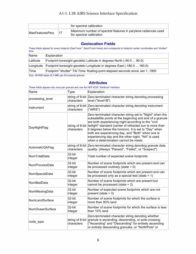
Geolocation Fields These fields appear for every footprint (GeoTrack * GeoXTrack times) and correspond to footprint center coordinates and "shutter" time.
Name Explanation Latitude Footprint boresight geodetic Latitude in degrees North (-90.0 ... 90.0) Longitude Footprint boresight geodetic Longitude in degrees East (-180.0 ... 180.0) Time Footprint "shutter" TAI Time: floating-point elapsed seconds since Jan 1, 1993 Size: 291600 bytes (0.3 MB) per 45-scanset granule
Attributes These fields appear only once per granule and use the HDF-EOS "Attribute" interface
Name Type Explanation
processing_level string of 8-bit characters
Zero-terminated character string denoting processing level ("level1B")
instrument string of 8-bit characters
Zero-terminated character string denoting instrument ("AIRS")
DayNightFlag string of 8-bit characters
Zero-terminated character string set to "Night" when the subsatellite points at the beginning and end of a granule are both experiencing night according to the "civil twilight" standard (center of refracted sun is more than 6 degrees below the horizon). It is set to "Day" when both are experiencing day, and "Both" when one is experiencing day and the other night. "NA" is used when a determination cannot be made.
AutomaticQAFlag string of 8-bit characters
Zero-terminated character string denoting granule data quality: (Always "Passed", "Failed", or "Suspect")
NumTotalData 32-bit integer Total number of expected scene footprints
NumProcessData 32-bit integer
Number of scene footprints which are present and can be processed routinely (state = 0)
NumSpecialData 32-bit integer
Number of scene footprints which are present and can be processed only as a special test (state = 1)
NumBadData 32-bit integer
Number of scene footprints which are present but cannot be processed (state = 2)
NumMissingData 32-bit integer
Number of expected scene footprints which are not present (state = 3)
NumLandSurface 32-bit integer
Number of scene footprints for which the surface is more than 90% land
NumOceanSurface 32-bit integer
Number of scene footprints for which the surface is less than 10% land
node_type string of 8-bit characters
Zero-terminated character string denoting whether granule is ascending, descending, or pole-crossing: ("Ascending" and "Descending" for entirely ascending or entirely descending granules, or "NorthPole" or

A1-1. L1B AIRS Science Interface Specification
9
"SouthPole" for pole-crossing granules. "NA" when determination cannot be made.)
start_year 32-bit integer Year in which granule started, UTC (e.g. 1999)
start_month 32-bit integer Month in which granule started, UTC (1 ... 12)
start_day 32-bit integer Day of month in which granule started, UTC (1 ... 31)
start_hour 32-bit integer Hour of day in which granule started, UTC (0 ... 23)
start_minute 32-bit integer Minute of hour in which granule started, UTC (0 ... 59)
start_sec 32-bit floating-point
Second of minute in which granule started, UTC (0.0 ... 59.0)
start_orbit 32-bit integer Orbit number of mission in which granule started
end_orbit 32-bit integer Orbit number of mission in which granule ended
orbit_path 32-bit integer
Orbit path of start orbit (1 ... 233 as defined by EOS project)
start_orbit_row 32-bit integer
Orbit row at start of granule (1 ... 248 as defined by EOS project)
end_orbit_row 32-bit integer
Orbit row at end of granule (1 ... 248 as defined by EOS project)
granule_number 32-bit integer Number of granule within day (1 ... 240)
num_scansets 32-bit integer Number of scansets in granule (1 ... 45)
num_scanlines 32-bit integer Number of scanlines in granule (3 * num_scansets)
start_Latitude 64-bit floating-point
Geodetic Latitude of spacecraft at start of granule in degrees North (-90.0 ... 90.0)
start_Longitude 64-bit floating-point
Geodetic Longitude of spacecraft at start of granule in degrees East (-180.0 ... 180.0)
start_Time 64-bit floating-point
TAI Time at start of granule (floating-point elapsed seconds since start of 1993)
end_Latitude 64-bit floating-point
Geodetic Latitude of spacecraft at end of granule in degrees North (-90.0 ... 90.0)
end_Longitude 64-bit floating-point
Geodetic Longitude of spacecraft at end of granule in degrees East (-180.0 ... 180.0)
end_Time 64-bit floating-point
TAI Time at end of granule (floating-point elapsed seconds since start of 1993)
eq_x_longitude 32-bit floating-point
Longitude of spacecraft at southward equator crossing nearest granule start in degrees East (-180.0 ... 180.0)
eq_x_tai 64-bit floating-point
Time of eq_x_longitude in TAI units (floating-point elapsed seconds since start of 1993)
A1-1. L1B AIRS Science Interface Specification
10
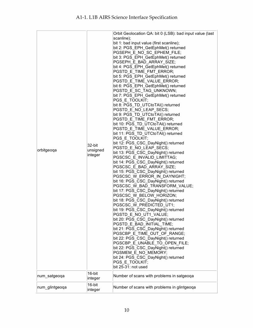
orbitgeoqa 32-bit unsigned integer
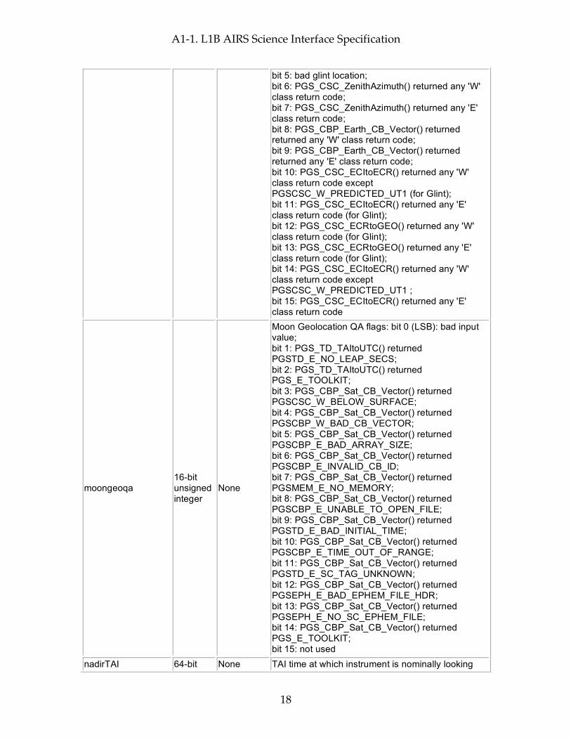
Orbit Geolocation QA: bit 0 (LSB): bad input value (last scanline); bit 1: bad input value (first scanline); bit 2: PGS_EPH_GetEphMet() returned PGSEPH_E_NO_SC_EPHEM_FILE; bit 3: PGS_EPH_GetEphMet() returned PGSEPH_E_BAD_ARRAY_SIZE; bit 4: PGS_EPH_GetEphMet() returned PGSTD_E_TIME_FMT_ERROR; bit 5: PGS_EPH_GetEphMet() returned PGSTD_E_TIME_VALUE_ERROR; bit 6: PGS_EPH_GetEphMet() returned PGSTD_E_SC_TAG_UNKNOWN; bit 7: PGS_EPH_GetEphMet() returned PGS_E_TOOLKIT; bit 8: PGS_TD_UTCtoTAI() returned PGSTD_E_NO_LEAP_SECS; bit 9: PGS_TD_UTCtoTAI() returned PGSTD_E_TIME_FMT_ERROR; bit 10: PGS_TD_UTCtoTAI() returned PGSTD_E_TIME_VALUE_ERROR; bit 11: PGS_TD_UTCtoTAI() returned PGS_E_TOOLKIT; bit 12: PGS_CSC_DayNight() returned PGSTD_E_NO_LEAP_SECS; bit 13: PGS_CSC_DayNight() returned PGSCSC_E_INVALID_LIMITTAG; bit 14: PGS_CSC_DayNight() returned PGSCSC_E_BAD_ARRAY_SIZE; bit 15: PGS_CSC_DayNight() returned PGSCSC_W_ERROR_IN_DAYNIGHT; bit 16: PGS_CSC_DayNight() returned PGSCSC_W_BAD_TRANSFORM_VALUE; bit 17: PGS_CSC_DayNight() returned PGSCSC_W_BELOW_HORIZON; bit 18: PGS_CSC_DayNight() returned PGSCSC_W_PREDICTED_UT1; bit 19: PGS_CSC_DayNight() returned PGSTD_E_NO_UT1_VALUE; bit 20: PGS_CSC_DayNight() returned PGSTD_E_BAD_INITIAL_TIME; bit 21: PGS_CSC_DayNight() returned PGSCBP_E_TIME_OUT_OF_RANGE; bit 22: PGS_CSC_DayNight() returned PGSCBP_E_UNABLE_TO_OPEN_FILE; bit 22: PGS_CSC_DayNight() returned PGSMEM_E_NO_MEMORY; bit 24: PGS_CSC_DayNight() returned PGS_E_TOOLKIT; bit 25-31: not used
num_satgeoqa 16-bit integer Number of scans with problems in satgeoqa
num_glintgeoqa 16-bit integer Number of scans with problems in glintgeoqa
A1-1. L1B AIRS Science Interface Specification
11
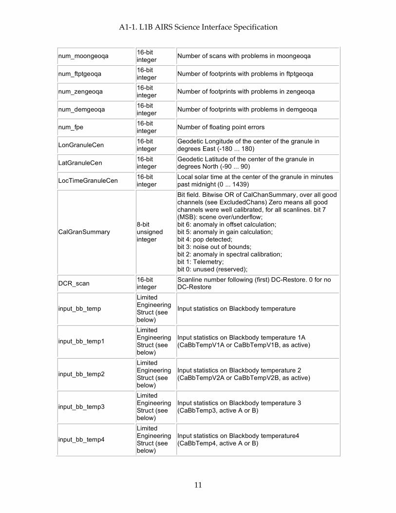
num_moongeoqa 16-bit integer Number of scans with problems in moongeoqa
num_ftptgeoqa 16-bit integer Number of footprints with problems in ftptgeoqa
num_zengeoqa 16-bit integer Number of footprints with problems in zengeoqa
num_demgeoqa 16-bit integer Number of footprints with problems in demgeoqa
num_fpe 16-bit integer Number of floating point errors
LonGranuleCen 16-bit integer
Geodetic Longitude of the center of the granule in degrees East (-180 ... 180)
LatGranuleCen 16-bit integer
Geodetic Latitude of the center of the granule in degrees North (-90 ... 90)
LocTimeGranuleCen 16-bit integer
Local solar time at the center of the granule in minutes past midnight (0 ... 1439)
CalGranSummary 8-bit unsigned integer
Bit field. Bitwise OR of CalChanSummary, over all good channels (see ExcludedChans) Zero means all good channels were well calibrated, for all scanlines. bit 7 (MSB): scene over/underflow; bit 6: anomaly in offset calculation; bit 5: anomaly in gain calculation; bit 4: pop detected; bit 3: noise out of bounds; bit 2: anomaly in spectral calibration; bit 1: Telemetry; bit 0: unused (reserved);
DCR_scan 16-bit integer
Scanline number following (first) DC-Restore. 0 for no DC-Restore
input_bb_temp
Limited Engineering Struct (see below)
Input statistics on Blackbody temperature
input_bb_temp1
Limited Engineering Struct (see below)
Input statistics on Blackbody temperature 1A (CaBbTempV1A or CaBbTempV1B, as active)
input_bb_temp2
Limited Engineering Struct (see below)
Input statistics on Blackbody temperature 2 (CaBbTempV2A or CaBbTempV2B, as active)
input_bb_temp3
Limited Engineering Struct (see below)
Input statistics on Blackbody temperature 3 (CaBbTemp3, active A or B)
input_bb_temp4
Limited Engineering Struct (see below)
Input statistics on Blackbody temperature4 (CaBbTemp4, active A or B)
A1-1. L1B AIRS Science Interface Specification
12
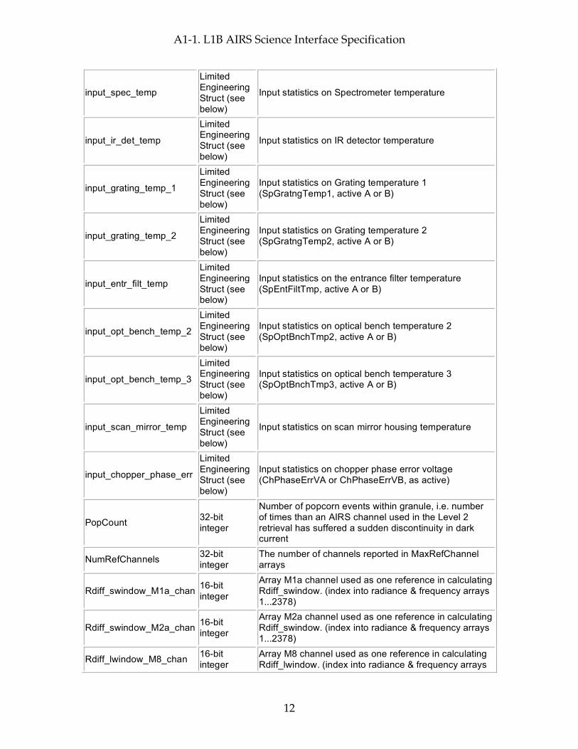
input_spec_temp
Limited Engineering Struct (see below)
Input statistics on Spectrometer temperature
input_ir_det_temp
Limited Engineering Struct (see below)
Input statistics on IR detector temperature
input_grating_temp_1
Limited Engineering Struct (see below)
Input statistics on Grating temperature 1 (SpGratngTemp1, active A or B)
input_grating_temp_2
Limited Engineering Struct (see below)
Input statistics on Grating temperature 2 (SpGratngTemp2, active A or B)
input_entr_filt_temp
Limited Engineering Struct (see below)
Input statistics on the entrance filter temperature (SpEntFiltTmp, active A or B)
input_opt_bench_temp_2
Limited Engineering Struct (see below)
Input statistics on optical bench temperature 2 (SpOptBnchTmp2, active A or B)
input_opt_bench_temp_3
Limited Engineering Struct (see below)
Input statistics on optical bench temperature 3 (SpOptBnchTmp3, active A or B)
input_scan_mirror_temp
Limited Engineering Struct (see below)
Input statistics on scan mirror housing temperature
input_chopper_phase_err
Limited Engineering Struct (see below)
Input statistics on chopper phase error voltage (ChPhaseErrVA or ChPhaseErrVB, as active)
PopCount 32-bit integer
Number of popcorn events within granule, i.e. number of times than an AIRS channel used in the Level 2 retrieval has suffered a sudden discontinuity in dark current
NumRefChannels 32-bit integer
The number of channels reported in MaxRefChannel arrays
Rdiff_swindow_M1a_chan 16-bit integer
Array M1a channel used as one reference in calculating Rdiff_swindow. (index into radiance & frequency arrays 1...2378)
Rdiff_swindow_M2a_chan 16-bit integer
Array M2a channel used as one reference in calculating Rdiff_swindow. (index into radiance & frequency arrays 1...2378)
Rdiff_lwindow_M8_chan 16-bit integer
Array M8 channel used as one reference in calculating Rdiff_lwindow. (index into radiance & frequency arrays

A1-1. L1B AIRS Science Interface Specification
13
1...2378)
Rdiff_lwindow_M9_chan 16-bit integer
Array M9 channel used as one reference in calculating Rdiff_lwindow. (index into radiance & frequency arrays 1...2378)
granules_present string of 8-bit characters
Zero-terminated character string denoting which adjacent granules were available for smoothing ("All" for both previous & next, "Prev" for previous but not next, "Next" for next but not previous, "None" for neither previous nor next)
spectral_TAI 64-bit floating-point
TAI time of (first) Spectral calibration. (floating-point elapsed seconds since start of 1993) 0 for no Spectral calibration occurred in this granule.
spec_shift_upwell 32-bit floating-point
Focal plane shift calculated in grating model fit to upwelling radiances (microns)
spec_shift_unc_upwell 32-bit floating-point
Uncertainty of the focal plane shift calculated in the grating model fit to upwelling radiances (microns)
spec_fl_upwell 32-bit floating-point
Focal length calculated in grating model fit to upwelling radiances (microns)
spec_fl_unc_upwell 32-bit floating-point
Uncertainty of focal length calculated in grating model fit to upwelling radiances (microns)
SpectralFeaturesUpwell 32-bit integer
The actual number of upwelling features for MaxFeaturesUpwell-sized arrays
spec_iter_upwell 16-bit integer
Number of amoeba iterations to fit the grating model to upwelling radiance feature positions
spec_clim_select 16-bit integer
Number of the climatology to which the upwelling features were fitted
spec_shift_pary 32-bit floating-point
Focal plane shift calculated in grating model fit to parylene radiances (microns)
spec_shift_unc_pary 32-bit floating-point
Uncertainty of the focal plane shift calculated in grating model fit to parylene radiances (microns)
spec_fl_pary 32-bit floating-point
Focal length calculated in grating model fit to parylene radiances (microns)
spec_fl_unc_pary 32-bit floating-point
Uncertainty of focal length calculated in grating model fit to parylene radiances (microns)
SpectralFeaturesPary 32-bit integer
The actual number of parylene features for MaxFeaturesPary-sized arrays
spec_iter_pary 16-bit integer
Number of amoeba iterations in fit the grating model to parylene radiance feature positions
DCRCount 32-bit integer
Number of times a Direct Current Restore was executed for any module
Size: 1371 bytes (0.0 MB) per granule
Per-Granule Data Fields These fields appear only once per granule and use the HDF-EOS "Field" interface
Name Type Extra Dimensions Explanation
CalChanSummary 8-bit unsigned integer
Channel (= 2378) Bit field. Bitwise OR of CalFlag, by channel, over all scanlines. Noise threshold and

A1-1. L1B AIRS Science Interface Specification
14
spectral quality added. Zero means the channel was well calibrated for all scanlines bit 7 (MSB): scene over/underflow; bit 6: anomaly in offset calculation; bit 5: anomaly in gain calculation; bit 4: pop detected; bit 3: noise out of bounds; bit 2: anomaly in spectral calibration; bit 1: Telemetry; bit 0: unused (reserved);
ExcludedChans 8-bit unsigned integer
Channel (= 2378)
An integer 0-6, indicating A/B detector weights. Used in L1B processing. 0 - A weight = B weight. Probably better that channels with state > 2; 1 - A-side only. Probably better that channels with state > 2; 2 - B-side only. Probably better that channels with state > 2; 3 - A weight = B weight. Probably better than channels with state = 6; 4 - A-side only. Probably better than channels with state = 6; 5 - B-side only. Probably better than channels with state = 6; 6 - A weight = B weight.
NeN 32-bit floating-point Channel (= 2378)
Noise-equivalent Radiance (radiance units) for an assumed 250K scene
input_scene_counts
Limited Engineering Struct (see below)
Channel (= 2378) Input statistics on scene data numbers
input_space_counts
Limited Engineering Struct (see below)
SpaceXTrack (= 4) * Channel (= 2378)
Input statistics on spaceview data numbers
input_space_signals
Limited Engineering Struct (see below)
SpaceXTrack (= 4) * Channel (= 2378)
Input statistics on spaceview signals (data numbers with offset subtracted)
input_space_diffs
Unlimited Engineering Struct (see below)
SpaceXTrack (= 4) * Channel (= 2378)
Statistics on differences between corresponding space views, for consecutive scanlines
input_bb_counts Limited Engineering Struct (see
Channel (= 2378) Input statistics on blackbody calibration data numbers
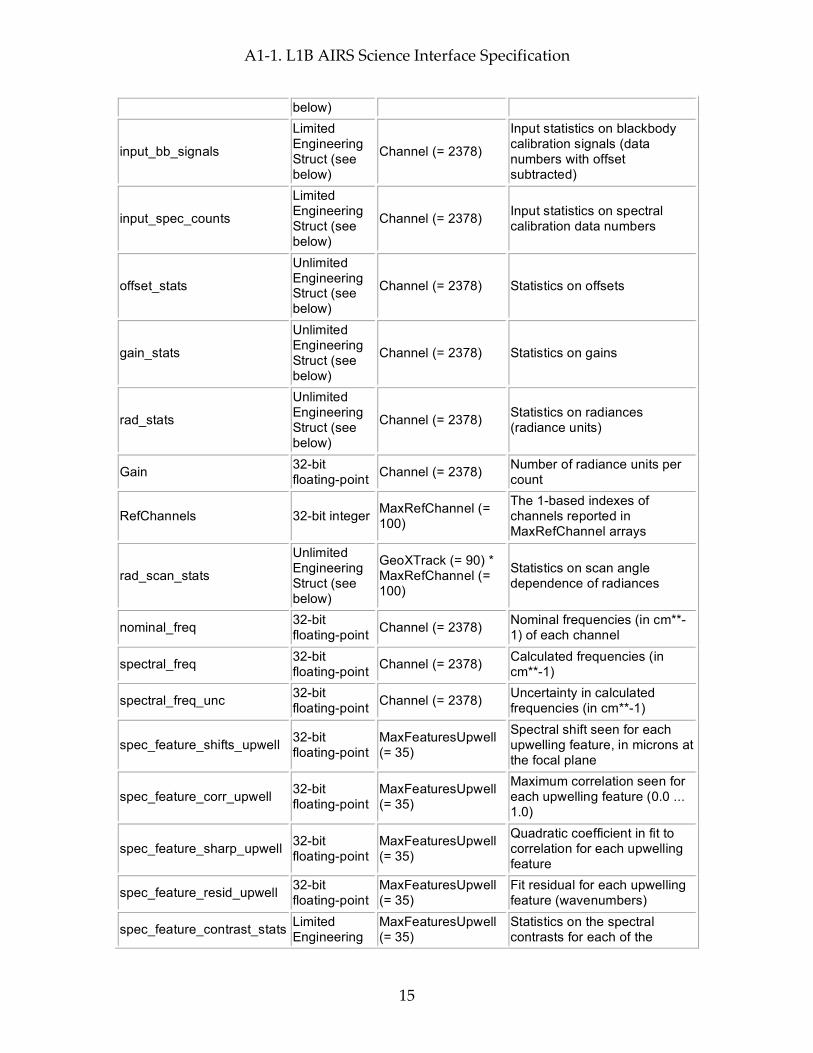
A1-1. L1B AIRS Science Interface Specification
15
below)
input_bb_signals
Limited Engineering Struct (see below)
Channel (= 2378)
Input statistics on blackbody calibration signals (data numbers with offset subtracted)
input_spec_counts
Limited Engineering Struct (see below)
Channel (= 2378) Input statistics on spectral calibration data numbers
offset_stats
Unlimited Engineering Struct (see below)
Channel (= 2378) Statistics on offsets
gain_stats
Unlimited Engineering Struct (see below)
Channel (= 2378) Statistics on gains
rad_stats
Unlimited Engineering Struct (see below)
Channel (= 2378) Statistics on radiances (radiance units)
Gain 32-bit floating-point Channel (= 2378) Number of radiance units per
count
RefChannels 32-bit integer MaxRefChannel (= 100)
The 1-based indexes of channels reported in MaxRefChannel arrays
rad_scan_stats
Unlimited Engineering Struct (see below)
GeoXTrack (= 90) * MaxRefChannel (= 100)
Statistics on scan angle dependence of radiances
nominal_freq 32-bit floating-point Channel (= 2378) Nominal frequencies (in cm**-
1) of each channel
spectral_freq 32-bit floating-point Channel (= 2378) Calculated frequencies (in
cm**-1)
spectral_freq_unc 32-bit floating-point Channel (= 2378) Uncertainty in calculated
frequencies (in cm**-1)
spec_feature_shifts_upwell 32-bit floating-point
MaxFeaturesUpwell (= 35)
Spectral shift seen for each upwelling feature, in microns at the focal plane
spec_feature_corr_upwell 32-bit floating-point
MaxFeaturesUpwell (= 35)
Maximum correlation seen for each upwelling feature (0.0 ... 1.0)
spec_feature_sharp_upwell 32-bit floating-point
MaxFeaturesUpwell (= 35)
Quadratic coefficient in fit to correlation for each upwelling feature
spec_feature_resid_upwell 32-bit floating-point
MaxFeaturesUpwell (= 35)
Fit residual for each upwelling feature (wavenumbers)
spec_feature_contrast_stats Limited Engineering
MaxFeaturesUpwell (= 35)
Statistics on the spectral contrasts for each of the

A1-1. L1B AIRS Science Interface Specification
16
Struct (see below)
upwelling features, for each of the scene footprints considered for spectral calibration
spec_feature_shifts_pary 32-bit floating-point
MaxFeaturesPary (= 17)
Spectral shift seen for each parylene feature, in microns at the focal plane
spec_feature_corr_pary 32-bit floating-point
MaxFeaturesPary (= 17)
Maximum correlation seen for each parylene feature (0.0 ... 1.0)
spec_feature_sharp_pary 32-bit floating-point
MaxFeaturesPary (= 17)
Quadratic coefficient in fit to correlation for each parylene feature
spec_feature_resid_pary 32-bit floating-point
MaxFeaturesPary (= 17)
Fit residual for each parylene feature (wavenumbers)
ave_pary_spectrum 32-bit floating-point Channel (= 2378)
The average parylene spectrum (over good scanlines), in milliWatts/m**2/cm**-1/steradian
Size: 3784916 bytes (3.8 MB) per granule
Along-Track Data Fields These fields appear once per scanline (GeoTrack times)
Name Type Extra Dimensions Explanation
satheight 32-bit floating-point
None Satellite altitude at nadirTAI in km above reference ellipsoid (e.g. 725.2)
satroll 32-bit floating-point
None
Satellite attitude roll angle at nadirTAI (-180.0 ... 180.0 angle about the +x (roll) ORB axis, +x axis is positively oriented in the direction of orbital flight completing an orthogonal triad with y and z.)
satpitch 32-bit floating-point
None
Satellite attitude pitch angle at nadirTAI (-180.0 ... 180.0 angle about +y (pitch) ORB axis. +y axis is oriented normal to the orbit plane with the positive sense opposite to that of the orbit's angular momentum vector H.)
satyaw 32-bit floating-point
None
Satellite attitude yaw angle at nadirTAI (-180.0 ... 180.0 angle about +z (yaw) axis. +z axis is positively oriented Earthward parallel to the satellite radius vector R from the spacecraft center of mass to the center of the Earth.)
satgeoqa 32-bit unsigned integer
None
Satellite Geolocation QA flags: bit 0 (LSB): bad input value; bit 1: PGS_TD_TAItoUTC() returned PGSTD_E_NO_LEAP_SECS; bit 2: PGS_TD_TAItoUTC() returned PGS_E_TOOLKIT; bit 3: PGS_EPH_EphemAttit() returned PGSEPH_W_BAD_EPHEM_VALUE;
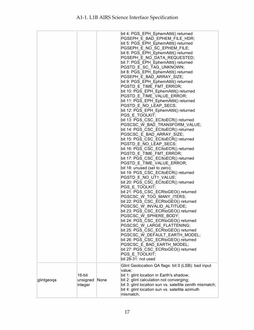
A1-1. L1B AIRS Science Interface Specification
17
bit 4: PGS_EPH_EphemAttit() returned PGSEPH_E_BAD_EPHEM_FILE_HDR; bit 5: PGS_EPH_EphemAttit() returned PGSEPH_E_NO_SC_EPHEM_FILE; bit 6: PGS_EPH_EphemAttit() returned PGSEPH_E_NO_DATA_REQUESTED; bit 7: PGS_EPH_EphemAttit() returned PGSTD_E_SC_TAG_UNKNOWN; bit 8: PGS_EPH_EphemAttit() returned PGSEPH_E_BAD_ARRAY_SIZE; bit 9: PGS_EPH_EphemAttit() returned PGSTD_E_TIME_FMT_ERROR; bit 10: PGS_EPH_EphemAttit() returned PGSTD_E_TIME_VALUE_ERROR; bit 11: PGS_EPH_EphemAttit() returned PGSTD_E_NO_LEAP_SECS; bit 12: PGS_EPH_EphemAttit() returned PGS_E_TOOLKIT; bit 13: PGS_CSC_ECItoECR() returned PGSCSC_W_BAD_TRANSFORM_VALUE; bit 14: PGS_CSC_ECItoECR() returned PGSCSC_E_BAD_ARRAY_SIZE; bit 15: PGS_CSC_ECItoECR() returned PGSTD_E_NO_LEAP_SECS; bit 16: PGS_CSC_ECItoECR() returned PGSTD_E_TIME_FMT_ERROR; bit 17: PGS_CSC_ECItoECR() returned PGSTD_E_TIME_VALUE_ERROR; bit 18: unused (set to zero); bit 19: PGS_CSC_ECItoECR() returned PGSTD_E_NO_UT1_VALUE; bit 20: PGS_CSC_ECItoECR() returned PGS_E_TOOLKIT; bit 21: PGS_CSC_ECRtoGEO() returned PGSCSC_W_TOO_MANY_ITERS; bit 22: PGS_CSC_ECRtoGEO() returned PGSCSC_W_INVALID_ALTITUDE; bit 23: PGS_CSC_ECRtoGEO() returned PGSCSC_W_SPHERE_BODY; bit 24: PGS_CSC_ECRtoGEO() returned PGSCSC_W_LARGE_FLATTENING; bit 25: PGS_CSC_ECRtoGEO() returned PGSCSC_W_DEFAULT_EARTH_MODEL; bit 26: PGS_CSC_ECRtoGEO() returned PGSCSC_E_BAD_EARTH_MODEL; bit 27: PGS_CSC_ECRtoGEO() returned PGS_E_TOOLKIT; bit 28-31: not used
glintgeoqa 16-bit unsigned integer
None
Glint Geolocation QA flags: bit 0 (LSB): bad input value; bit 1: glint location in Earth's shadow; bit 2: glint calculation not converging; bit 3: glint location sun vs. satellite zenith mismatch; bit 4: glint location sun vs. satellite azimuth mismatch;
A1-1. L1B AIRS Science Interface Specification
18
bit 5: bad glint location; bit 6: PGS_CSC_ZenithAzimuth() returned any 'W' class return code; bit 7: PGS_CSC_ZenithAzimuth() returned any 'E' class return code; bit 8: PGS_CBP_Earth_CB_Vector() returned returned any 'W' class return code; bit 9: PGS_CBP_Earth_CB_Vector() returned returned any 'E' class return code; bit 10: PGS_CSC_ECItoECR() returned any 'W' class return code except PGSCSC_W_PREDICTED_UT1 (for Glint); bit 11: PGS_CSC_ECItoECR() returned any 'E' class return code (for Glint); bit 12: PGS_CSC_ECRtoGEO() returned any 'W' class return code (for Glint); bit 13: PGS_CSC_ECRtoGEO() returned any 'E' class return code (for Glint); bit 14: PGS_CSC_ECItoECR() returned any 'W' class return code except PGSCSC_W_PREDICTED_UT1 ; bit 15: PGS_CSC_ECItoECR() returned any 'E' class return code
moongeoqa 16-bit unsigned integer
None
Moon Geolocation QA flags: bit 0 (LSB): bad input value; bit 1: PGS_TD_TAItoUTC() returned PGSTD_E_NO_LEAP_SECS; bit 2: PGS_TD_TAItoUTC() returned PGS_E_TOOLKIT; bit 3: PGS_CBP_Sat_CB_Vector() returned PGSCSC_W_BELOW_SURFACE; bit 4: PGS_CBP_Sat_CB_Vector() returned PGSCBP_W_BAD_CB_VECTOR; bit 5: PGS_CBP_Sat_CB_Vector() returned PGSCBP_E_BAD_ARRAY_SIZE; bit 6: PGS_CBP_Sat_CB_Vector() returned PGSCBP_E_INVALID_CB_ID; bit 7: PGS_CBP_Sat_CB_Vector() returned PGSMEM_E_NO_MEMORY; bit 8: PGS_CBP_Sat_CB_Vector() returned PGSCBP_E_UNABLE_TO_OPEN_FILE; bit 9: PGS_CBP_Sat_CB_Vector() returned PGSTD_E_BAD_INITIAL_TIME; bit 10: PGS_CBP_Sat_CB_Vector() returned PGSCBP_E_TIME_OUT_OF_RANGE; bit 11: PGS_CBP_Sat_CB_Vector() returned PGSTD_E_SC_TAG_UNKNOWN; bit 12: PGS_CBP_Sat_CB_Vector() returned PGSEPH_E_BAD_EPHEM_FILE_HDR; bit 13: PGS_CBP_Sat_CB_Vector() returned PGSEPH_E_NO_SC_EPHEM_FILE; bit 14: PGS_CBP_Sat_CB_Vector() returned PGS_E_TOOLKIT; bit 15: not used
nadirTAI 64-bit None TAI time at which instrument is nominally looking

A1-1. L1B AIRS Science Interface Specification
19
floating-point
directly down. (between footprints 15 & 16 for AMSU or between footprints 45 & 46 for AIRS/Vis & HSB) (floating-point elapsed seconds since start of 1993)
sat_lat 64-bit floating-point
None Satellite geodetic latitude in degrees North (-90.0 ... 90.0)
sat_lon 64-bit floating-point
None Satellite geodetic longitude in degrees East (-180.0 ... 180.0)
scan_node_type 8-bit integer None 'A' for ascending, 'D' for descending, 'N' for North-
Polar, 'S' for South-Polar
glintlat 32-bit floating-point
None Solar glint geodetic latitude in degrees North at nadirTAI (-90.0 ... 90.0)
glintlon 32-bit floating-point
None Solar glint geodetic longitude in degrees East at nadirTAI (-180.0 ... 180.0)
CalScanSummary 8-bit unsigned integer
None
Bit field. Bitwise OR of CalFlag over the good channel list (see ExcludedChans). Zero means all "good" channels were well calibrated for this scanline bit 7 (MSB): scene over/underflow; bit 6: anomaly in offset calculation; bit 5: anomaly in gain calculation; bit 4: pop detected; bit 3: DCR Occurred; bit 2: Moon in View; bit 1: telemetry out of limit condition; bit 0: cold scene noise
CalFlag 8-bit unsigned integer
Channel (= 2378)
Bit field, by channel, for the current scanline. Zero means the channel was well calibrated, for this scanline. bit 7 (MSB): scene over/underflow; bit 6: anomaly in offset calculation; bit 5: anomaly in gain calculation; bit 4: pop detected; bit 3: DCR Occurred; bit 2: Moon in View; bit 1: telemetry out of limit condition; bit 0: cold scene noise
SpaceViewDelta 32-bit floating-point
Channel (= 2378)
The mean of the four spaceviews immediately following the Earth views in the scanline, minus the mean of the spaceviews immediately preceding the Earth views in the scanline (also the magnitude of a "pop" in this scanline, when the "pop detected" bit is set in CalFlag.) (data numbers)
spaceview_selection 8-bit unsigned integer
None
Indicates which footprints were included for this scan. Each bit is high when the corresponding space view is used in the spaceview offset calculation. (See L1B Processing Requirements, section 6.2); LSB is first space view.
A1-1. L1B AIRS Science Interface Specification
20
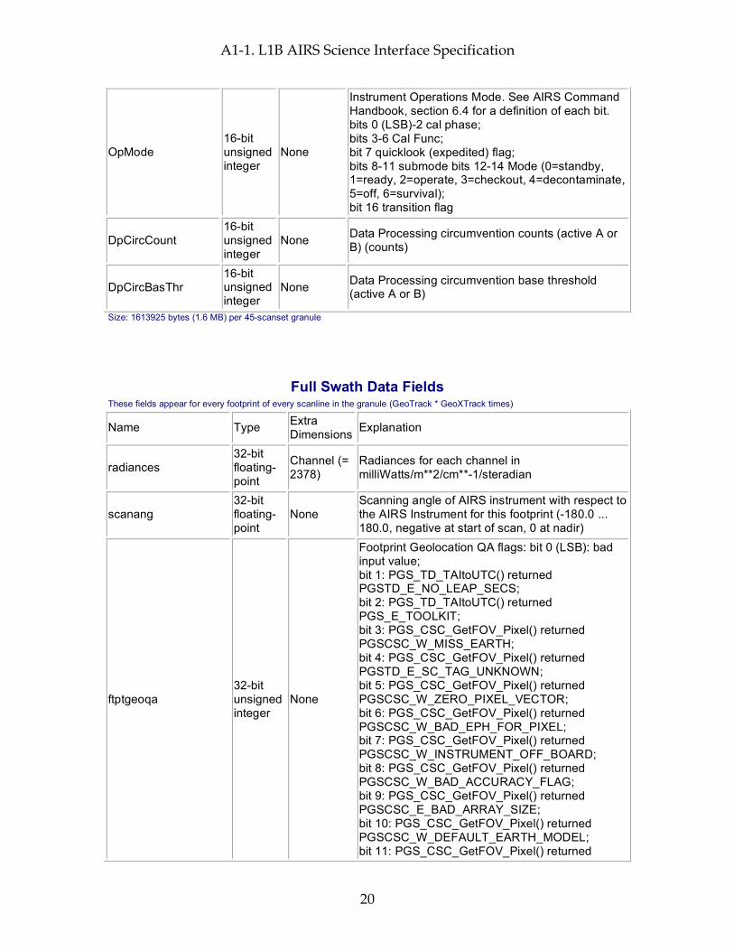
OpMode 16-bit unsigned integer
None
Instrument Operations Mode. See AIRS Command Handbook, section 6.4 for a definition of each bit. bits 0 (LSB)-2 cal phase; bits 3-6 Cal Func; bit 7 quicklook (expedited) flag; bits 8-11 submode bits 12-14 Mode (0=standby, 1=ready, 2=operate, 3=checkout, 4=decontaminate, 5=off, 6=survival); bit 16 transition flag
DpCircCount 16-bit unsigned integer
None Data Processing circumvention counts (active A or B) (counts)
DpCircBasThr 16-bit unsigned integer
None Data Processing circumvention base threshold (active A or B)
Size: 1613925 bytes (1.6 MB) per 45-scanset granule
Full Swath Data Fields These fields appear for every footprint of every scanline in the granule (GeoTrack * GeoXTrack times)
Name Type Extra Dimensions Explanation
radiances 32-bit floating-point
Channel (= 2378)
Radiances for each channel in milliWatts/m**2/cm**-1/steradian
scanang 32-bit floating-point
None Scanning angle of AIRS instrument with respect to the AIRS Instrument for this footprint (-180.0 ... 180.0, negative at start of scan, 0 at nadir)
ftptgeoqa 32-bit unsigned integer
None
Footprint Geolocation QA flags: bit 0 (LSB): bad input value; bit 1: PGS_TD_TAItoUTC() returned PGSTD_E_NO_LEAP_SECS; bit 2: PGS_TD_TAItoUTC() returned PGS_E_TOOLKIT; bit 3: PGS_CSC_GetFOV_Pixel() returned PGSCSC_W_MISS_EARTH; bit 4: PGS_CSC_GetFOV_Pixel() returned PGSTD_E_SC_TAG_UNKNOWN; bit 5: PGS_CSC_GetFOV_Pixel() returned PGSCSC_W_ZERO_PIXEL_VECTOR; bit 6: PGS_CSC_GetFOV_Pixel() returned PGSCSC_W_BAD_EPH_FOR_PIXEL; bit 7: PGS_CSC_GetFOV_Pixel() returned PGSCSC_W_INSTRUMENT_OFF_BOARD; bit 8: PGS_CSC_GetFOV_Pixel() returned PGSCSC_W_BAD_ACCURACY_FLAG; bit 9: PGS_CSC_GetFOV_Pixel() returned PGSCSC_E_BAD_ARRAY_SIZE; bit 10: PGS_CSC_GetFOV_Pixel() returned PGSCSC_W_DEFAULT_EARTH_MODEL; bit 11: PGS_CSC_GetFOV_Pixel() returned
A1-1. L1B AIRS Science Interface Specification
21
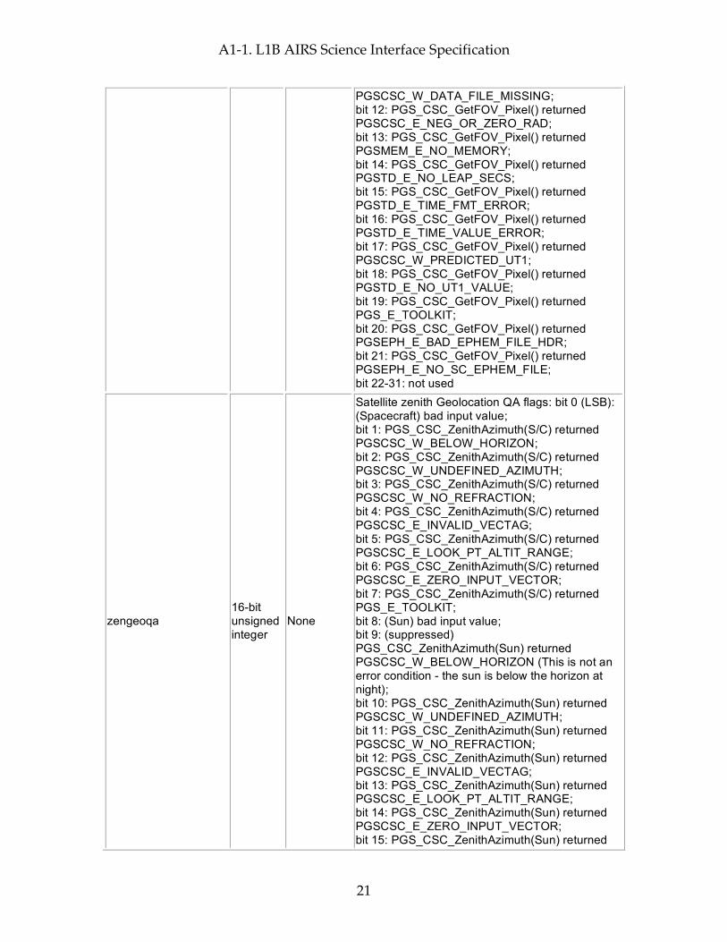
PGSCSC_W_DATA_FILE_MISSING; bit 12: PGS_CSC_GetFOV_Pixel() returned PGSCSC_E_NEG_OR_ZERO_RAD; bit 13: PGS_CSC_GetFOV_Pixel() returned PGSMEM_E_NO_MEMORY; bit 14: PGS_CSC_GetFOV_Pixel() returned PGSTD_E_NO_LEAP_SECS; bit 15: PGS_CSC_GetFOV_Pixel() returned PGSTD_E_TIME_FMT_ERROR; bit 16: PGS_CSC_GetFOV_Pixel() returned PGSTD_E_TIME_VALUE_ERROR; bit 17: PGS_CSC_GetFOV_Pixel() returned PGSCSC_W_PREDICTED_UT1; bit 18: PGS_CSC_GetFOV_Pixel() returned PGSTD_E_NO_UT1_VALUE; bit 19: PGS_CSC_GetFOV_Pixel() returned PGS_E_TOOLKIT; bit 20: PGS_CSC_GetFOV_Pixel() returned PGSEPH_E_BAD_EPHEM_FILE_HDR; bit 21: PGS_CSC_GetFOV_Pixel() returned PGSEPH_E_NO_SC_EPHEM_FILE; bit 22-31: not used
zengeoqa 16-bit unsigned integer
None
Satellite zenith Geolocation QA flags: bit 0 (LSB): (Spacecraft) bad input value; bit 1: PGS_CSC_ZenithAzimuth(S/C) returned PGSCSC_W_BELOW_HORIZON; bit 2: PGS_CSC_ZenithAzimuth(S/C) returned PGSCSC_W_UNDEFINED_AZIMUTH; bit 3: PGS_CSC_ZenithAzimuth(S/C) returned PGSCSC_W_NO_REFRACTION; bit 4: PGS_CSC_ZenithAzimuth(S/C) returned PGSCSC_E_INVALID_VECTAG; bit 5: PGS_CSC_ZenithAzimuth(S/C) returned PGSCSC_E_LOOK_PT_ALTIT_RANGE; bit 6: PGS_CSC_ZenithAzimuth(S/C) returned PGSCSC_E_ZERO_INPUT_VECTOR; bit 7: PGS_CSC_ZenithAzimuth(S/C) returned PGS_E_TOOLKIT; bit 8: (Sun) bad input value; bit 9: (suppressed) PGS_CSC_ZenithAzimuth(Sun) returned PGSCSC_W_BELOW_HORIZON (This is not an error condition - the sun is below the horizon at night); bit 10: PGS_CSC_ZenithAzimuth(Sun) returned PGSCSC_W_UNDEFINED_AZIMUTH; bit 11: PGS_CSC_ZenithAzimuth(Sun) returned PGSCSC_W_NO_REFRACTION; bit 12: PGS_CSC_ZenithAzimuth(Sun) returned PGSCSC_E_INVALID_VECTAG; bit 13: PGS_CSC_ZenithAzimuth(Sun) returned PGSCSC_E_LOOK_PT_ALTIT_RANGE; bit 14: PGS_CSC_ZenithAzimuth(Sun) returned PGSCSC_E_ZERO_INPUT_VECTOR; bit 15: PGS_CSC_ZenithAzimuth(Sun) returned

A1-1. L1B AIRS Science Interface Specification
22
PGS_E_TOOLKIT
demgeoqa 16-bit unsigned integer
None
Digital Elevation Model (DEM) Geolocation QA flags: bit 0 (LSB): bad input value; bit 1: Could not allocate memory; bit 2: Too close to North or South pole. Excluded; bit 3: Layer resolution incompatibility. Excluded; bit 4: Any DEM Routine (elev) returned PGSDEM_E_IMPROPER_TAG; bit 5: Any DEM Routine (elev) returned PGSDEM_E_CANNOT_ACCESS_DATA; bit 6: Any DEM Routine (land/water) returned PGSDEM_E_IMPROPER_TAG; bit 7: Any DEM Routine (land/water) returned PGSDEM_E_CANNOT_ACCESS_DATA; bit 8: Reserved for future layers; bit 9: Reserved for future layers; bit 10: PGS_DEM_GetRegion(elev) returned PGSDEM_M_FILLVALUE_INCLUDED; bit 11: PGS_DEM_GetRegion(land/water) returned PGSDEM_M_FILLVALUE_INCLUDED; bit 12: Reserved for future layers; bit 13: PGS_DEM_GetRegion(all) returned PGSDEM_M_MULTIPLE_RESOLUTIONS; bit 14: PGS_CSC_GetFOV_Pixel() returned any 'W' class return code except PGSCSC_W_PREDICTED_UT1; bit 15: PGS_CSC_GetFOV_Pixel() returned any 'E' class return code
satzen 32-bit floating-point
None
Spacecraft zenith angle (0.0 ... 180.0) degrees from zenith (measured relative to the geodetic vertical on the reference (WGS84) spheroid and including corrections outlined in EOS SDP toolkit for normal accuracy.)
satazi 32-bit floating-point
None Spacecraft azimuth angle (-180.0 ... 180.0) degrees E of N GEO)
solzen 32-bit floating-point
None
Solar zenith angle (0.0 ... 180.0) degrees from zenith (measured relative to the geodetic vertical on the reference (WGS84) spheroid and including corrections outlined in EOS SDP toolkit for normal accuracy.)
solazi 32-bit floating-point
None Solar azimuth angle (-180.0 ... 180.0) degrees E of N GEO)
sun_glint_distance 16-bit integer None
Distance (km) from footprint center to location of the sun glint (-9999 for unknown, 30000 for no glint visible because spacecraft is in Earth's shadow)
topog 32-bit floating-point
None Mean topography in meters above reference ellipsoid
topog_err 32-bit None Error estimate for topog
A1-1. L1B AIRS Science Interface Specification
23
floating-point
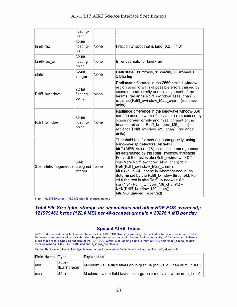
landFrac 32-bit floating-point
None Fraction of spot that is land (0.0 ... 1.0)
landFrac_err 32-bit floating-point
None Error estimate for landFrac
state 32-bit integer None Data state: 0:Process, 1:Special, 2:Erroneous,
3:Missing
Rdiff_swindow 32-bit floating-point
None
Radiance difference in the 2560 cm**-1 window region used to warn of possible errors caused by scene non-uniformity and misalignment of the beams: radiance(Rdiff_swindow_M1a_chan) - radiance(Rdiff_swindow_M2a_chan). (radiance units)
Rdiff_lwindow 32-bit floating-point
None
Radiance difference in the longwave window(850 cm**-1) used to warn of possible errors caused by scene non-uniformity and misalignment of the beams: radiance(Rdiff_lwindow_M8_chan) - radiance(Rdiff_lwindow_M9_chan). (radiance units)
SceneInhomogeneous 8-bit unsigned integer
None
Threshold test for scene inhomogeneity, using band-overlap detectors (bit fields).; bit 7 (MSB, value 128): scene is inhomogeneous, as determined by the Rdiff_swindow threshold. For v4.0 the test is abs(Rdiff_swindow) > 5 * sqrt(NeN(Rdiff_swindow_M1a_chan)^2 + NeN(Rdiff_swindow_M2a_chan)); bit 6 (value 64): scene is inhomogeneous, as determined by the Rdiff_lwindow threshold. For v4.0 the test is abs(Rdiff_lwindow) > 5 * sqrt(NeN(Rdiff_lwindow_M8_chan)^2 + NeN(Rdiff_lwindow_M9_chan)); bits 5-0: unused (reserved)
Size: 116287650 bytes (116.3 MB) per 45-scanset granule
Total File Size (plus storage for dimensions and other HDF-EOS overhead): 121979462 bytes (122.0 MB) per 45-scanset granule = 29275.1 MB per day
Special AIRS Types AIRS works around the lack of support for records in HDF-EOS Swath by grouping related fields into pseudo-records. HDF-EOS fieldnames are generated by concatenating the pseudo-record name with the subfield name, putting a "." character in between. Since these record types do not exist at the HDF-EOS swath level, reading subfield "min" of AIRS field "input_scene_counts" involves reading HDF-EOS Swath field "input_scene_counts.min".
Limited Engineering Struct: This type is used for engineering data fields for which there are known "yellow" limits
Field Name Type Explanation
min 32-bit floating-point Minimum value field takes on in granule (not valid when num_in = 0)
max 32-bit Maximum value field takes on in granule (not valid when num_in = 0)

A1-1. L1B AIRS Science Interface Specification
24
floating-point
mean 32-bit floating-point Mean of values field takes on in granule (not valid when num_in = 0)
dev 32-bit floating-point
Standard Deviation of values field takes on in granule (not valid when num_in < 2)
num_in 32-bit integer Count of in-range values field takes on in granule num_lo 32-bit integer Count of out-of-range low values field takes on in granule num_hi 32-bit integer Count of out-of-range high values field takes on in granule
num_bad 32-bit integer Count of occassions on which field takes on invalid flag value (-9999) in granule
range_min 32-bit floating-point Minimum in-range value.
range_max 32-bit floating-point Maximum in-range value.
missing 8-bit integer
Missing limits flags. Bit 0 (LSB) is 1 when yellow low (range_min) limit is missing; Bit 1 is high when yellow high (range_max) limit is missing; other bits unused, set to 0.
max_track 32-bit integer GeoTrack index (counting from 1) where max was found max_xtrack 32-bit integer GeoXTrack index (counting from 1) where max was found
min_track 32-bit integer GeoTrack index (counting from 1) where min was found
min_xtrack 32-bit integer GeoXTrack index (counting from 1) where min was found
Unlimited Engineering Struct: This type is used for engineering data fields for which there are NOT known "yellow" limits
Field Name Type Explanation
min 32-bit floating-point Minimum value field takes on in granule (not valid when num = 0)
max 32-bit floating-point Maximum value field takes on in granule (not valid when num = 0)
mean 32-bit floating-point Mean of values field takes on in granule (not valid when num = 0)
dev 32-bit floating-point
Standard Deviation of values field takes on in granule (not valid when num < 2)
num 32-bit integer Count of occurrences of field in granule (not including those counted in num_bad)
num_bad 32-bit integer Count of occassions on which field takes on invalid flag value (-9999) in granule
max_track 32-bit integer GeoTrack index (counting from 1) where max was found max_xtrack 32-bit integer GeoXTrack index (counting from 1) where max was found min_track 32-bit integer GeoTrack index (counting from 1) where min was found min_xtrack 32-bit integer GeoXTrack index (counting from 1) where min was found

A1-1. L1B AIRS Science Interface Specification
25
A1-2. L1B AIRS QA Interface Specification
26
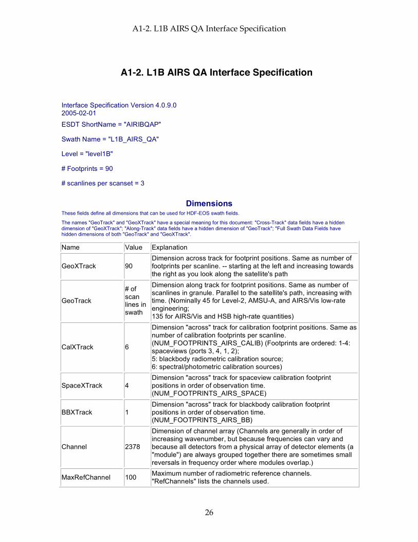
A1-2. L1B AIRS QA Interface Specification
Interface Specification Version 4.0.9.0 2005-02-01
ESDT ShortName = "AIRIBQAP"
Swath Name = "L1B_AIRS_QA"
Level = "level1B"
# Footprints = 90
# scanlines per scanset = 3
Dimensions These fields define all dimensions that can be used for HDF-EOS swath fields.
The names "GeoTrack" and "GeoXTrack" have a special meaning for this document: "Cross-Track" data fields have a hidden dimension of "GeoXTrack"; "Along-Track" data fields have a hidden dimension of "GeoTrack"; "Full Swath Data Fields have hidden dimensions of both "GeoTrack" and "GeoXTrack".
Name Value Explanation
GeoXTrack 90 Dimension across track for footprint positions. Same as number of footprints per scanline. -- starting at the left and increasing towards the right as you look along the satellite's path
GeoTrack
# of scan lines in swath
Dimension along track for footprint positions. Same as number of scanlines in granule. Parallel to the satellite's path, increasing with time. (Nominally 45 for Level-2, AMSU-A, and AIRS/Vis low-rate engineering; 135 for AIRS/Vis and HSB high-rate quantities)
CalXTrack 6
Dimension "across" track for calibration footprint positions. Same as number of calibration footprints per scanline. (NUM_FOOTPRINTS_AIRS_CALIB) (Footprints are ordered: 1-4: spaceviews (ports 3, 4, 1, 2); 5: blackbody radiometric calibration source; 6: spectral/photometric calibration sources)
SpaceXTrack 4 Dimension "across" track for spaceview calibration footprint positions in order of observation time. (NUM_FOOTPRINTS_AIRS_SPACE)
BBXTrack 1 Dimension "across" track for blackbody calibration footprint positions in order of observation time. (NUM_FOOTPRINTS_AIRS_BB)
Channel 2378
Dimension of channel array (Channels are generally in order of increasing wavenumber, but because frequencies can vary and because all detectors from a physical array of detector elements (a "module") are always grouped together there are sometimes small reversals in frequency order where modules overlap.)
MaxRefChannel 100 Maximum number of radiometric reference channels. "RefChannels" lists the channels used.

A1-2. L1B AIRS QA Interface Specification
27
MaxFeaturesUpwell 35 Maximum number of spectral features in upwelling radiances used for spectral calibration
MaxFeaturesPary 17 Maximum number of spectral features in parylene radiances used for spectral calibration
Geolocation Fields These fields appear for every footprint (GeoTrack * GeoXTrack times) and correspond to footprint center coordinates and "shutter" time.
Name Explanation Latitude Footprint boresight geodetic Latitude in degrees North (-90.0 ... 90.0) Longitude Footprint boresight geodetic Longitude in degrees East (-180.0 ... 180.0) Time Footprint "shutter" TAI Time: floating-point elapsed seconds since Jan 1, 1993 Size: 291600 bytes (0.3 MB) per 45-scanset granule
Attributes These fields appear only once per granule and use the HDF-EOS "Attribute" interface
Name Type Explanation
processing_level string of 8-bit characters
Zero-terminated character string denoting processing level ("level1B")
instrument string of 8-bit characters
Zero-terminated character string denoting instrument ("AIRS")
DayNightFlag string of 8-bit characters
Zero-terminated character string set to "Night" when the subsatellite points at the beginning and end of a granule are both experiencing night according to the "civil twilight" standard (center of refracted sun is more than 6 degrees below the horizon). It is set to "Day" when both are experiencing day, and "Both" when one is experiencing day and the other night. "NA" is used when a determination cannot be made.
AutomaticQAFlag string of 8-bit characters
Zero-terminated character string denoting granule data quality: (Always "Passed", "Failed", or "Suspect")
NumTotalData 32-bit integer Total number of expected scene footprints
NumProcessData 32-bit integer
Number of scene footprints which are present and can be processed routinely (state = 0)
NumSpecialData 32-bit integer
Number of scene footprints which are present and can be processed only as a special test (state = 1)
NumBadData 32-bit integer
Number of scene footprints which are present but cannot be processed (state = 2)
NumMissingData 32-bit integer
Number of expected scene footprints which are not present (state = 3)
NumLandSurface 32-bit integer
Number of scene footprints for which the surface is more than 90% land
NumOceanSurface 32-bit integer
Number of scene footprints for which the surface is less than 10% land
node_type string of 8-bit characters
Zero-terminated character string denoting whether granule is ascending, descending, or pole-crossing: ("Ascending" and "Descending" for entirely ascending

A1-2. L1B AIRS QA Interface Specification
28
or entirely descending granules, or "NorthPole" or "SouthPole" for pole-crossing granules. "NA" when determination cannot be made.)
start_year 32-bit integer Year in which granule started, UTC (e.g. 1999)
start_month 32-bit integer Month in which granule started, UTC (1 ... 12)
start_day 32-bit integer Day of month in which granule started, UTC (1 ... 31)
start_hour 32-bit integer Hour of day in which granule started, UTC (0 ... 23)
start_minute 32-bit integer Minute of hour in which granule started, UTC (0 ... 59)
start_sec 32-bit floating-point
Second of minute in which granule started, UTC (0.0 ... 59.0)
start_orbit 32-bit integer Orbit number of mission in which granule started
end_orbit 32-bit integer Orbit number of mission in which granule ended
orbit_path 32-bit integer
Orbit path of start orbit (1 ... 233 as defined by EOS project)
start_orbit_row 32-bit integer
Orbit row at start of granule (1 ... 248 as defined by EOS project)
end_orbit_row 32-bit integer
Orbit row at end of granule (1 ... 248 as defined by EOS project)
granule_number 32-bit integer Number of granule within day (1 ... 240)
num_scansets 32-bit integer Number of scansets in granule (1 ... 45)
num_scanlines 32-bit integer Number of scanlines in granule (3 * num_scansets)
start_Latitude 64-bit floating-point
Geodetic Latitude of spacecraft at start of granule in degrees North (-90.0 ... 90.0)
start_Longitude 64-bit floating-point
Geodetic Longitude of spacecraft at start of granule in degrees East (-180.0 ... 180.0)
start_Time 64-bit floating-point
TAI Time at start of granule (floating-point elapsed seconds since start of 1993)
end_Latitude 64-bit floating-point
Geodetic Latitude of spacecraft at end of granule in degrees North (-90.0 ... 90.0)
end_Longitude 64-bit floating-point
Geodetic Longitude of spacecraft at end of granule in degrees East (-180.0 ... 180.0)
end_Time 64-bit floating-point
TAI Time at end of granule (floating-point elapsed seconds since start of 1993)
eq_x_longitude 32-bit floating-point
Longitude of spacecraft at southward equator crossing nearest granule start in degrees East (-180.0 ... 180.0)
eq_x_tai 64-bit floating-point
Time of eq_x_longitude in TAI units (floating-point elapsed seconds since start of 1993)

A1-2. L1B AIRS QA Interface Specification
29
orbitgeoqa 32-bit unsigned integer
Orbit Geolocation QA: bit 0 (LSB): bad input value (last scanline); bit 1: bad input value (first scanline); bit 2: PGS_EPH_GetEphMet() returned PGSEPH_E_NO_SC_EPHEM_FILE; bit 3: PGS_EPH_GetEphMet() returned PGSEPH_E_BAD_ARRAY_SIZE; bit 4: PGS_EPH_GetEphMet() returned PGSTD_E_TIME_FMT_ERROR; bit 5: PGS_EPH_GetEphMet() returned PGSTD_E_TIME_VALUE_ERROR; bit 6: PGS_EPH_GetEphMet() returned PGSTD_E_SC_TAG_UNKNOWN; bit 7: PGS_EPH_GetEphMet() returned PGS_E_TOOLKIT; bit 8: PGS_TD_UTCtoTAI() returned PGSTD_E_NO_LEAP_SECS; bit 9: PGS_TD_UTCtoTAI() returned PGSTD_E_TIME_FMT_ERROR; bit 10: PGS_TD_UTCtoTAI() returned PGSTD_E_TIME_VALUE_ERROR; bit 11: PGS_TD_UTCtoTAI() returned PGS_E_TOOLKIT; bit 12: PGS_CSC_DayNight() returned PGSTD_E_NO_LEAP_SECS; bit 13: PGS_CSC_DayNight() returned PGSCSC_E_INVALID_LIMITTAG; bit 14: PGS_CSC_DayNight() returned PGSCSC_E_BAD_ARRAY_SIZE; bit 15: PGS_CSC_DayNight() returned PGSCSC_W_ERROR_IN_DAYNIGHT; bit 16: PGS_CSC_DayNight() returned PGSCSC_W_BAD_TRANSFORM_VALUE; bit 17: PGS_CSC_DayNight() returned PGSCSC_W_BELOW_HORIZON; bit 18: PGS_CSC_DayNight() returned PGSCSC_W_PREDICTED_UT1; bit 19: PGS_CSC_DayNight() returned PGSTD_E_NO_UT1_VALUE; bit 20: PGS_CSC_DayNight() returned PGSTD_E_BAD_INITIAL_TIME; bit 21: PGS_CSC_DayNight() returned PGSCBP_E_TIME_OUT_OF_RANGE; bit 22: PGS_CSC_DayNight() returned PGSCBP_E_UNABLE_TO_OPEN_FILE; bit 22: PGS_CSC_DayNight() returned PGSMEM_E_NO_MEMORY; bit 24: PGS_CSC_DayNight() returned PGS_E_TOOLKIT; bit 25-31: not used
num_satgeoqa 16-bit integer Number of scans with problems in satgeoqa
num_glintgeoqa 16-bit integer Number of scans with problems in glintgeoqa

A1-2. L1B AIRS QA Interface Specification
30
num_moongeoqa 16-bit integer Number of scans with problems in moongeoqa
num_ftptgeoqa 16-bit integer Number of footprints with problems in ftptgeoqa
num_zengeoqa 16-bit integer Number of footprints with problems in zengeoqa
num_demgeoqa 16-bit integer Number of footprints with problems in demgeoqa
num_fpe 16-bit integer Number of floating point errors
LonGranuleCen 16-bit integer
Geodetic Longitude of the center of the granule in degrees East (-180 ... 180)
LatGranuleCen 16-bit integer
Geodetic Latitude of the center of the granule in degrees North (-90 ... 90)
LocTimeGranuleCen 16-bit integer
Local solar time at the center of the granule in minutes past midnight (0 ... 1439)
CalGranSummary 8-bit unsigned integer
Bit field. Bitwise OR of CalChanSummary, over all good channels (see ExcludedChans) Zero means all good channels were well calibrated, for all scanlines. bit 7 (MSB): scene over/underflow; bit 6: anomaly in offset calculation; bit 5: anomaly in gain calculation; bit 4: pop detected; bit 3: noise out of bounds; bit 2: anomaly in spectral calibration; bit 1: Telemetry; bit 0: unused (reserved);
DCR_scan 16-bit integer
Scanline number following (first) DC-Restore. 0 for no DC-Restore
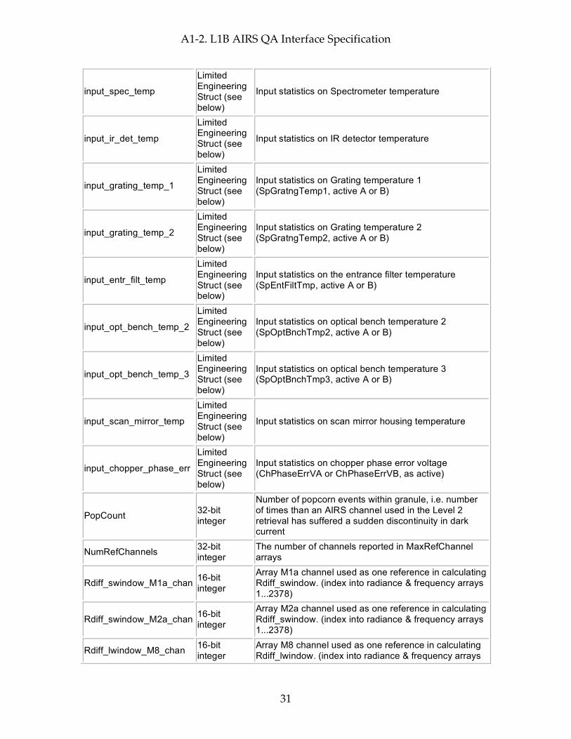
input_bb_temp
Limited Engineering Struct (see below)
Input statistics on Blackbody temperature
input_bb_temp1
Limited Engineering Struct (see below)
Input statistics on Blackbody temperature 1A (CaBbTempV1A or CaBbTempV1B, as active)
input_bb_temp2
Limited Engineering Struct (see below)
Input statistics on Blackbody temperature 2 (CaBbTempV2A or CaBbTempV2B, as active)
input_bb_temp3
Limited Engineering Struct (see below)
Input statistics on Blackbody temperature 3 (CaBbTemp3, active A or B)
input_bb_temp4
Limited Engineering Struct (see below)
Input statistics on Blackbody temperature4 (CaBbTemp4, active A or B)
A1-2. L1B AIRS QA Interface Specification
31
input_spec_temp
Limited Engineering Struct (see below)
Input statistics on Spectrometer temperature
input_ir_det_temp
Limited Engineering Struct (see below)
Input statistics on IR detector temperature
input_grating_temp_1
Limited Engineering Struct (see below)
Input statistics on Grating temperature 1 (SpGratngTemp1, active A or B)
input_grating_temp_2
Limited Engineering Struct (see below)
Input statistics on Grating temperature 2 (SpGratngTemp2, active A or B)
input_entr_filt_temp
Limited Engineering Struct (see below)
Input statistics on the entrance filter temperature (SpEntFiltTmp, active A or B)
input_opt_bench_temp_2
Limited Engineering Struct (see below)
Input statistics on optical bench temperature 2 (SpOptBnchTmp2, active A or B)
input_opt_bench_temp_3
Limited Engineering Struct (see below)
Input statistics on optical bench temperature 3 (SpOptBnchTmp3, active A or B)
input_scan_mirror_temp
Limited Engineering Struct (see below)
Input statistics on scan mirror housing temperature
input_chopper_phase_err
Limited Engineering Struct (see below)
Input statistics on chopper phase error voltage (ChPhaseErrVA or ChPhaseErrVB, as active)
PopCount 32-bit integer
Number of popcorn events within granule, i.e. number of times than an AIRS channel used in the Level 2 retrieval has suffered a sudden discontinuity in dark current
NumRefChannels 32-bit integer
The number of channels reported in MaxRefChannel arrays
Rdiff_swindow_M1a_chan 16-bit integer
Array M1a channel used as one reference in calculating Rdiff_swindow. (index into radiance & frequency arrays 1...2378)
Rdiff_swindow_M2a_chan 16-bit integer
Array M2a channel used as one reference in calculating Rdiff_swindow. (index into radiance & frequency arrays 1...2378)
Rdiff_lwindow_M8_chan 16-bit integer
Array M8 channel used as one reference in calculating Rdiff_lwindow. (index into radiance & frequency arrays
A1-2. L1B AIRS QA Interface Specification
32
1...2378)
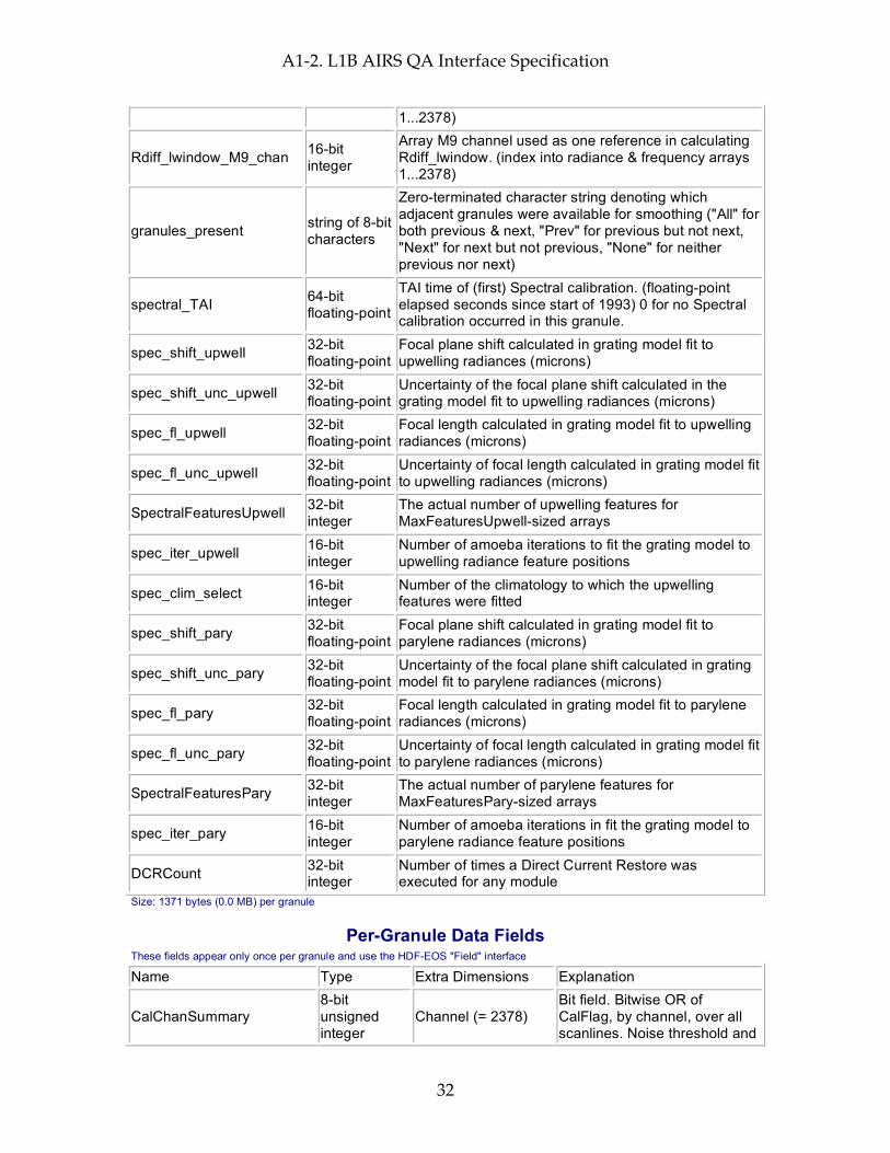
Rdiff_lwindow_M9_chan 16-bit integer
Array M9 channel used as one reference in calculating Rdiff_lwindow. (index into radiance & frequency arrays 1...2378)
granules_present string of 8-bit characters
Zero-terminated character string denoting which adjacent granules were available for smoothing ("All" for both previous & next, "Prev" for previous but not next, "Next" for next but not previous, "None" for neither previous nor next)
spectral_TAI 64-bit floating-point
TAI time of (first) Spectral calibration. (floating-point elapsed seconds since start of 1993) 0 for no Spectral calibration occurred in this granule.
spec_shift_upwell 32-bit floating-point
Focal plane shift calculated in grating model fit to upwelling radiances (microns)
spec_shift_unc_upwell 32-bit floating-point
Uncertainty of the focal plane shift calculated in the grating model fit to upwelling radiances (microns)
spec_fl_upwell 32-bit floating-point
Focal length calculated in grating model fit to upwelling radiances (microns)
spec_fl_unc_upwell 32-bit floating-point
Uncertainty of focal length calculated in grating model fit to upwelling radiances (microns)
SpectralFeaturesUpwell 32-bit integer
The actual number of upwelling features for MaxFeaturesUpwell-sized arrays
spec_iter_upwell 16-bit integer
Number of amoeba iterations to fit the grating model to upwelling radiance feature positions
spec_clim_select 16-bit integer
Number of the climatology to which the upwelling features were fitted
spec_shift_pary 32-bit floating-point
Focal plane shift calculated in grating model fit to parylene radiances (microns)
spec_shift_unc_pary 32-bit floating-point
Uncertainty of the focal plane shift calculated in grating model fit to parylene radiances (microns)
spec_fl_pary 32-bit floating-point
Focal length calculated in grating model fit to parylene radiances (microns)
spec_fl_unc_pary 32-bit floating-point
Uncertainty of focal length calculated in grating model fit to parylene radiances (microns)
SpectralFeaturesPary 32-bit integer
The actual number of parylene features for MaxFeaturesPary-sized arrays
spec_iter_pary 16-bit integer
Number of amoeba iterations in fit the grating model to parylene radiance feature positions
DCRCount 32-bit integer
Number of times a Direct Current Restore was executed for any module
Size: 1371 bytes (0.0 MB) per granule
Per-Granule Data Fields These fields appear only once per granule and use the HDF-EOS "Field" interface
Name Type Extra Dimensions Explanation
CalChanSummary 8-bit unsigned integer
Channel (= 2378) Bit field. Bitwise OR of CalFlag, by channel, over all scanlines. Noise threshold and
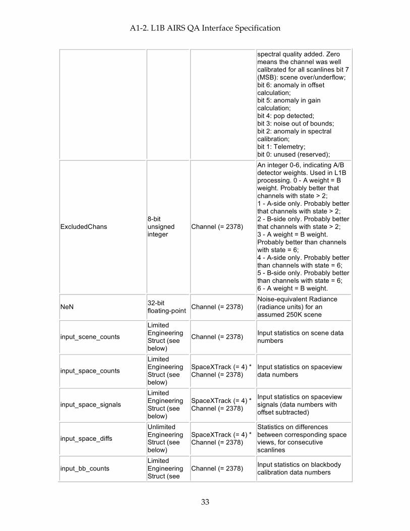
A1-2. L1B AIRS QA Interface Specification
33
spectral quality added. Zero means the channel was well calibrated for all scanlines bit 7 (MSB): scene over/underflow; bit 6: anomaly in offset calculation; bit 5: anomaly in gain calculation; bit 4: pop detected; bit 3: noise out of bounds; bit 2: anomaly in spectral calibration; bit 1: Telemetry; bit 0: unused (reserved);
ExcludedChans 8-bit unsigned integer
Channel (= 2378)
An integer 0-6, indicating A/B detector weights. Used in L1B processing. 0 - A weight = B weight. Probably better that channels with state > 2; 1 - A-side only. Probably better that channels with state > 2; 2 - B-side only. Probably better that channels with state > 2; 3 - A weight = B weight. Probably better than channels with state = 6; 4 - A-side only. Probably better than channels with state = 6; 5 - B-side only. Probably better than channels with state = 6; 6 - A weight = B weight.
NeN 32-bit floating-point Channel (= 2378)
Noise-equivalent Radiance (radiance units) for an assumed 250K scene
input_scene_counts
Limited Engineering Struct (see below)
Channel (= 2378) Input statistics on scene data numbers
input_space_counts
Limited Engineering Struct (see below)
SpaceXTrack (= 4) * Channel (= 2378)
Input statistics on spaceview data numbers
input_space_signals
Limited Engineering Struct (see below)
SpaceXTrack (= 4) * Channel (= 2378)
Input statistics on spaceview signals (data numbers with offset subtracted)
input_space_diffs
Unlimited Engineering Struct (see below)
SpaceXTrack (= 4) * Channel (= 2378)
Statistics on differences between corresponding space views, for consecutive scanlines
input_bb_counts Limited Engineering Struct (see
Channel (= 2378) Input statistics on blackbody calibration data numbers

A1-2. L1B AIRS QA Interface Specification
34
below)
input_bb_signals
Limited Engineering Struct (see below)
Channel (= 2378)
Input statistics on blackbody calibration signals (data numbers with offset subtracted)
input_spec_counts
Limited Engineering Struct (see below)
Channel (= 2378) Input statistics on spectral calibration data numbers
offset_stats
Unlimited Engineering Struct (see below)
Channel (= 2378) Statistics on offsets
gain_stats
Unlimited Engineering Struct (see below)
Channel (= 2378) Statistics on gains
rad_stats
Unlimited Engineering Struct (see below)
Channel (= 2378) Statistics on radiances (radiance units)
Gain 32-bit floating-point Channel (= 2378) Number of radiance units per
count
RefChannels 32-bit integer MaxRefChannel (= 100)
The 1-based indexes of channels reported in MaxRefChannel arrays
rad_scan_stats
Unlimited Engineering Struct (see below)
GeoXTrack (= 90) * MaxRefChannel (= 100)
Statistics on scan angle dependence of radiances
nominal_freq 32-bit floating-point Channel (= 2378) Nominal frequencies (in cm**-
1) of each channel
spectral_freq 32-bit floating-point Channel (= 2378) Calculated frequencies (in
cm**-1)
spectral_freq_unc 32-bit floating-point Channel (= 2378) Uncertainty in calculated
frequencies (in cm**-1)
spec_feature_shifts_upwell 32-bit floating-point
MaxFeaturesUpwell (= 35)
Spectral shift seen for each upwelling feature, in microns at the focal plane
spec_feature_corr_upwell 32-bit floating-point
MaxFeaturesUpwell (= 35)
Maximum correlation seen for each upwelling feature (0.0 ... 1.0)
spec_feature_sharp_upwell 32-bit floating-point
MaxFeaturesUpwell (= 35)
Quadratic coefficient in fit to correlation for each upwelling feature
spec_feature_resid_upwell 32-bit floating-point
MaxFeaturesUpwell (= 35)
Fit residual for each upwelling feature (wavenumbers)
spec_feature_contrast_stats Limited Engineering
MaxFeaturesUpwell (= 35)
Statistics on the spectral contrasts for each of the
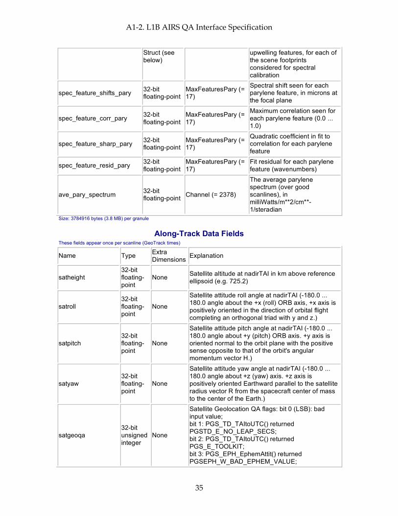
A1-2. L1B AIRS QA Interface Specification
35
Struct (see below)
upwelling features, for each of the scene footprints considered for spectral calibration
spec_feature_shifts_pary 32-bit floating-point
MaxFeaturesPary (= 17)
Spectral shift seen for each parylene feature, in microns at the focal plane
spec_feature_corr_pary 32-bit floating-point
MaxFeaturesPary (= 17)
Maximum correlation seen for each parylene feature (0.0 ... 1.0)
spec_feature_sharp_pary 32-bit floating-point
MaxFeaturesPary (= 17)
Quadratic coefficient in fit to correlation for each parylene feature
spec_feature_resid_pary 32-bit floating-point
MaxFeaturesPary (= 17)
Fit residual for each parylene feature (wavenumbers)
ave_pary_spectrum 32-bit floating-point Channel (= 2378)
The average parylene spectrum (over good scanlines), in milliWatts/m**2/cm**-1/steradian
Size: 3784916 bytes (3.8 MB) per granule
Along-Track Data Fields These fields appear once per scanline (GeoTrack times)
Name Type Extra Dimensions Explanation
satheight 32-bit floating-point
None Satellite altitude at nadirTAI in km above reference ellipsoid (e.g. 725.2)
satroll 32-bit floating-point
None
Satellite attitude roll angle at nadirTAI (-180.0 ... 180.0 angle about the +x (roll) ORB axis, +x axis is positively oriented in the direction of orbital flight completing an orthogonal triad with y and z.)
satpitch 32-bit floating-point
None
Satellite attitude pitch angle at nadirTAI (-180.0 ... 180.0 angle about +y (pitch) ORB axis. +y axis is oriented normal to the orbit plane with the positive sense opposite to that of the orbit's angular momentum vector H.)
satyaw 32-bit floating-point
None
Satellite attitude yaw angle at nadirTAI (-180.0 ... 180.0 angle about +z (yaw) axis. +z axis is positively oriented Earthward parallel to the satellite radius vector R from the spacecraft center of mass to the center of the Earth.)
satgeoqa 32-bit unsigned integer
None
Satellite Geolocation QA flags: bit 0 (LSB): bad input value; bit 1: PGS_TD_TAItoUTC() returned PGSTD_E_NO_LEAP_SECS; bit 2: PGS_TD_TAItoUTC() returned PGS_E_TOOLKIT; bit 3: PGS_EPH_EphemAttit() returned PGSEPH_W_BAD_EPHEM_VALUE;

A1-2. L1B AIRS QA Interface Specification
36
bit 4: PGS_EPH_EphemAttit() returned PGSEPH_E_BAD_EPHEM_FILE_HDR; bit 5: PGS_EPH_EphemAttit() returned PGSEPH_E_NO_SC_EPHEM_FILE; bit 6: PGS_EPH_EphemAttit() returned PGSEPH_E_NO_DATA_REQUESTED; bit 7: PGS_EPH_EphemAttit() returned PGSTD_E_SC_TAG_UNKNOWN; bit 8: PGS_EPH_EphemAttit() returned PGSEPH_E_BAD_ARRAY_SIZE; bit 9: PGS_EPH_EphemAttit() returned PGSTD_E_TIME_FMT_ERROR; bit 10: PGS_EPH_EphemAttit() returned PGSTD_E_TIME_VALUE_ERROR; bit 11: PGS_EPH_EphemAttit() returned PGSTD_E_NO_LEAP_SECS; bit 12: PGS_EPH_EphemAttit() returned PGS_E_TOOLKIT; bit 13: PGS_CSC_ECItoECR() returned PGSCSC_W_BAD_TRANSFORM_VALUE; bit 14: PGS_CSC_ECItoECR() returned PGSCSC_E_BAD_ARRAY_SIZE; bit 15: PGS_CSC_ECItoECR() returned PGSTD_E_NO_LEAP_SECS; bit 16: PGS_CSC_ECItoECR() returned PGSTD_E_TIME_FMT_ERROR; bit 17: PGS_CSC_ECItoECR() returned PGSTD_E_TIME_VALUE_ERROR; bit 18: unused (set to zero); bit 19: PGS_CSC_ECItoECR() returned PGSTD_E_NO_UT1_VALUE; bit 20: PGS_CSC_ECItoECR() returned PGS_E_TOOLKIT; bit 21: PGS_CSC_ECRtoGEO() returned PGSCSC_W_TOO_MANY_ITERS; bit 22: PGS_CSC_ECRtoGEO() returned PGSCSC_W_INVALID_ALTITUDE; bit 23: PGS_CSC_ECRtoGEO() returned PGSCSC_W_SPHERE_BODY; bit 24: PGS_CSC_ECRtoGEO() returned PGSCSC_W_LARGE_FLATTENING; bit 25: PGS_CSC_ECRtoGEO() returned PGSCSC_W_DEFAULT_EARTH_MODEL; bit 26: PGS_CSC_ECRtoGEO() returned PGSCSC_E_BAD_EARTH_MODEL; bit 27: PGS_CSC_ECRtoGEO() returned PGS_E_TOOLKIT; bit 28-31: not used
glintgeoqa 16-bit unsigned integer
None
Glint Geolocation QA flags: bit 0 (LSB): bad input value; bit 1: glint location in Earth's shadow; bit 2: glint calculation not converging; bit 3: glint location sun vs. satellite zenith mismatch; bit 4: glint location sun vs. satellite azimuth mismatch;

A1-2. L1B AIRS QA Interface Specification
37
bit 5: bad glint location; bit 6: PGS_CSC_ZenithAzimuth() returned any 'W' class return code; bit 7: PGS_CSC_ZenithAzimuth() returned any 'E' class return code; bit 8: PGS_CBP_Earth_CB_Vector() returned returned any 'W' class return code; bit 9: PGS_CBP_Earth_CB_Vector() returned returned any 'E' class return code; bit 10: PGS_CSC_ECItoECR() returned any 'W' class return code except PGSCSC_W_PREDICTED_UT1 (for Glint); bit 11: PGS_CSC_ECItoECR() returned any 'E' class return code (for Glint); bit 12: PGS_CSC_ECRtoGEO() returned any 'W' class return code (for Glint); bit 13: PGS_CSC_ECRtoGEO() returned any 'E' class return code (for Glint); bit 14: PGS_CSC_ECItoECR() returned any 'W' class return code except PGSCSC_W_PREDICTED_UT1 ; bit 15: PGS_CSC_ECItoECR() returned any 'E' class return code
moongeoqa 16-bit unsigned integer
None
Moon Geolocation QA flags: bit 0 (LSB): bad input value; bit 1: PGS_TD_TAItoUTC() returned PGSTD_E_NO_LEAP_SECS; bit 2: PGS_TD_TAItoUTC() returned PGS_E_TOOLKIT; bit 3: PGS_CBP_Sat_CB_Vector() returned PGSCSC_W_BELOW_SURFACE; bit 4: PGS_CBP_Sat_CB_Vector() returned PGSCBP_W_BAD_CB_VECTOR; bit 5: PGS_CBP_Sat_CB_Vector() returned PGSCBP_E_BAD_ARRAY_SIZE; bit 6: PGS_CBP_Sat_CB_Vector() returned PGSCBP_E_INVALID_CB_ID; bit 7: PGS_CBP_Sat_CB_Vector() returned PGSMEM_E_NO_MEMORY; bit 8: PGS_CBP_Sat_CB_Vector() returned PGSCBP_E_UNABLE_TO_OPEN_FILE; bit 9: PGS_CBP_Sat_CB_Vector() returned PGSTD_E_BAD_INITIAL_TIME; bit 10: PGS_CBP_Sat_CB_Vector() returned PGSCBP_E_TIME_OUT_OF_RANGE; bit 11: PGS_CBP_Sat_CB_Vector() returned PGSTD_E_SC_TAG_UNKNOWN; bit 12: PGS_CBP_Sat_CB_Vector() returned PGSEPH_E_BAD_EPHEM_FILE_HDR; bit 13: PGS_CBP_Sat_CB_Vector() returned PGSEPH_E_NO_SC_EPHEM_FILE; bit 14: PGS_CBP_Sat_CB_Vector() returned PGS_E_TOOLKIT; bit 15: not used
nadirTAI 64-bit None TAI time at which instrument is nominally looking
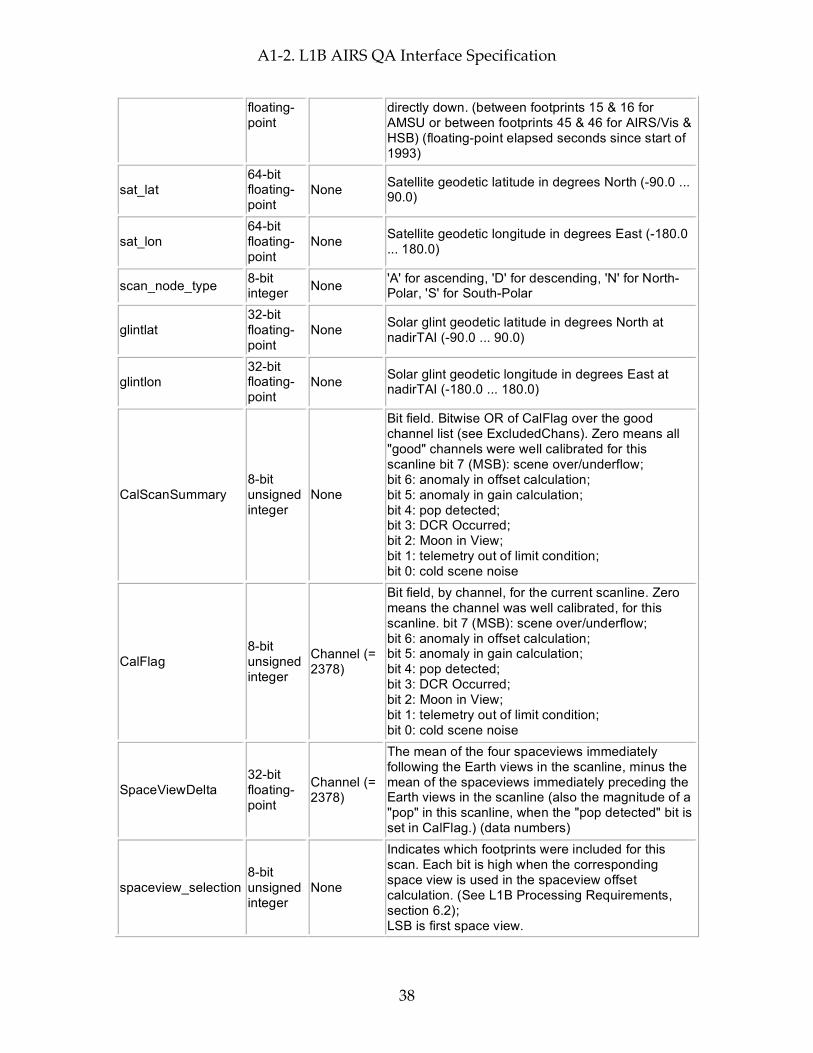
A1-2. L1B AIRS QA Interface Specification
38
floating-point
directly down. (between footprints 15 & 16 for AMSU or between footprints 45 & 46 for AIRS/Vis & HSB) (floating-point elapsed seconds since start of 1993)
sat_lat 64-bit floating-point
None Satellite geodetic latitude in degrees North (-90.0 ... 90.0)
sat_lon 64-bit floating-point
None Satellite geodetic longitude in degrees East (-180.0 ... 180.0)
scan_node_type 8-bit integer None 'A' for ascending, 'D' for descending, 'N' for North-
Polar, 'S' for South-Polar
glintlat 32-bit floating-point
None Solar glint geodetic latitude in degrees North at nadirTAI (-90.0 ... 90.0)
glintlon 32-bit floating-point
None Solar glint geodetic longitude in degrees East at nadirTAI (-180.0 ... 180.0)
CalScanSummary 8-bit unsigned integer
None
Bit field. Bitwise OR of CalFlag over the good channel list (see ExcludedChans). Zero means all "good" channels were well calibrated for this scanline bit 7 (MSB): scene over/underflow; bit 6: anomaly in offset calculation; bit 5: anomaly in gain calculation; bit 4: pop detected; bit 3: DCR Occurred; bit 2: Moon in View; bit 1: telemetry out of limit condition; bit 0: cold scene noise
CalFlag 8-bit unsigned integer
Channel (= 2378)
Bit field, by channel, for the current scanline. Zero means the channel was well calibrated, for this scanline. bit 7 (MSB): scene over/underflow; bit 6: anomaly in offset calculation; bit 5: anomaly in gain calculation; bit 4: pop detected; bit 3: DCR Occurred; bit 2: Moon in View; bit 1: telemetry out of limit condition; bit 0: cold scene noise
SpaceViewDelta 32-bit floating-point
Channel (= 2378)
The mean of the four spaceviews immediately following the Earth views in the scanline, minus the mean of the spaceviews immediately preceding the Earth views in the scanline (also the magnitude of a "pop" in this scanline, when the "pop detected" bit is set in CalFlag.) (data numbers)
spaceview_selection 8-bit unsigned integer
None
Indicates which footprints were included for this scan. Each bit is high when the corresponding space view is used in the spaceview offset calculation. (See L1B Processing Requirements, section 6.2); LSB is first space view.
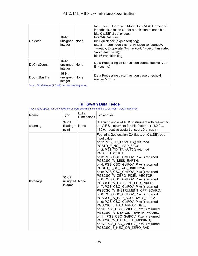
A1-2. L1B AIRS QA Interface Specification
39
OpMode 16-bit unsigned integer
None
Instrument Operations Mode. See AIRS Command Handbook, section 6.4 for a definition of each bit. bits 0 (LSB)-2 cal phase; bits 3-6 Cal Func; bit 7 quicklook (expedited) flag; bits 8-11 submode bits 12-14 Mode (0=standby, 1=ready, 2=operate, 3=checkout, 4=decontaminate, 5=off, 6=survival); bit 16 transition flag
DpCircCount 16-bit unsigned integer
None Data Processing circumvention counts (active A or B) (counts)
DpCircBasThr 16-bit unsigned integer
None Data Processing circumvention base threshold (active A or B)
Size: 1613925 bytes (1.6 MB) per 45-scanset granule
Full Swath Data Fields These fields appear for every footprint of every scanline in the granule (GeoTrack * GeoXTrack times)
Name Type Extra Dimensions Explanation
scanang 32-bit floating-point
None Scanning angle of AIRS instrument with respect to the AIRS Instrument for this footprint (-180.0 ... 180.0, negative at start of scan, 0 at nadir)
ftptgeoqa 32-bit unsigned integer
None
Footprint Geolocation QA flags: bit 0 (LSB): bad input value; bit 1: PGS_TD_TAItoUTC() returned PGSTD_E_NO_LEAP_SECS; bit 2: PGS_TD_TAItoUTC() returned PGS_E_TOOLKIT; bit 3: PGS_CSC_GetFOV_Pixel() returned PGSCSC_W_MISS_EARTH; bit 4: PGS_CSC_GetFOV_Pixel() returned PGSTD_E_SC_TAG_UNKNOWN; bit 5: PGS_CSC_GetFOV_Pixel() returned PGSCSC_W_ZERO_PIXEL_VECTOR; bit 6: PGS_CSC_GetFOV_Pixel() returned PGSCSC_W_BAD_EPH_FOR_PIXEL; bit 7: PGS_CSC_GetFOV_Pixel() returned PGSCSC_W_INSTRUMENT_OFF_BOARD; bit 8: PGS_CSC_GetFOV_Pixel() returned PGSCSC_W_BAD_ACCURACY_FLAG; bit 9: PGS_CSC_GetFOV_Pixel() returned PGSCSC_E_BAD_ARRAY_SIZE; bit 10: PGS_CSC_GetFOV_Pixel() returned PGSCSC_W_DEFAULT_EARTH_MODEL; bit 11: PGS_CSC_GetFOV_Pixel() returned PGSCSC_W_DATA_FILE_MISSING; bit 12: PGS_CSC_GetFOV_Pixel() returned PGSCSC_E_NEG_OR_ZERO_RAD;
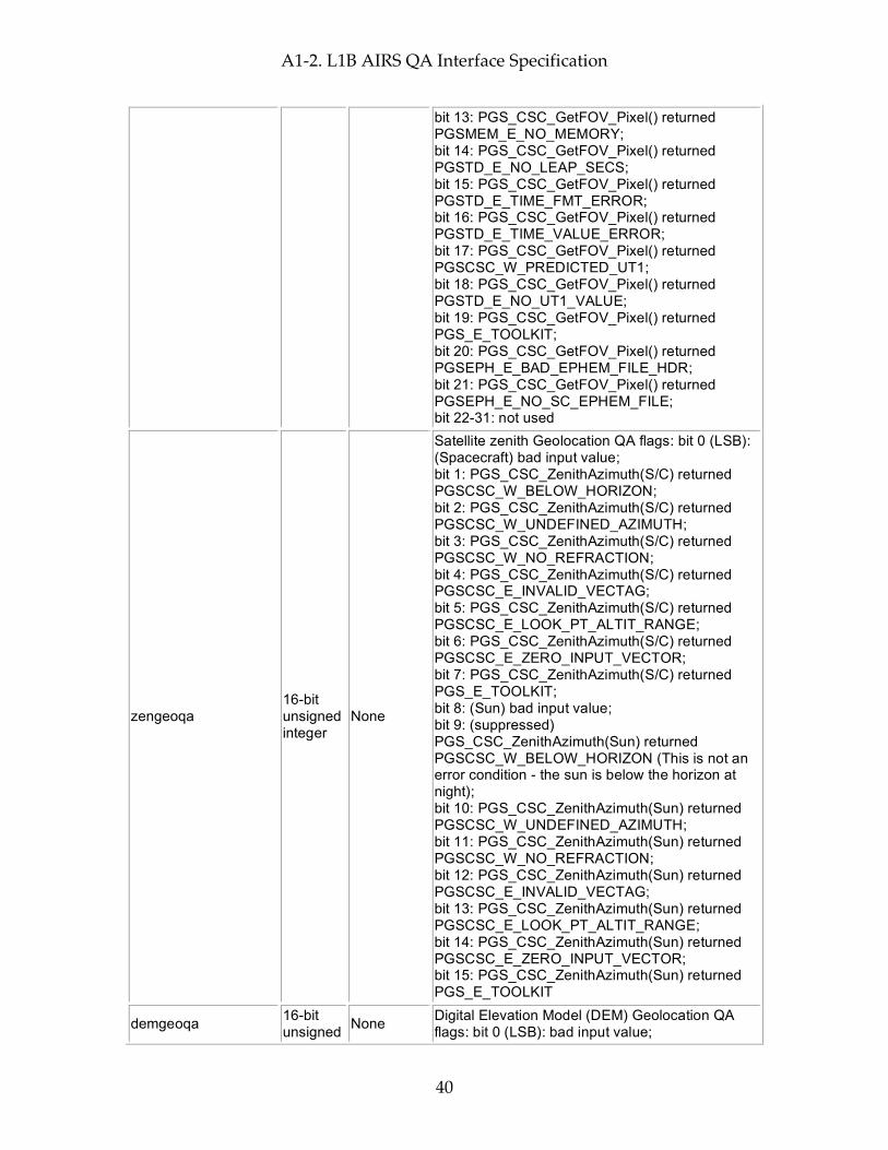
A1-2. L1B AIRS QA Interface Specification
40
bit 13: PGS_CSC_GetFOV_Pixel() returned PGSMEM_E_NO_MEMORY; bit 14: PGS_CSC_GetFOV_Pixel() returned PGSTD_E_NO_LEAP_SECS; bit 15: PGS_CSC_GetFOV_Pixel() returned PGSTD_E_TIME_FMT_ERROR; bit 16: PGS_CSC_GetFOV_Pixel() returned PGSTD_E_TIME_VALUE_ERROR; bit 17: PGS_CSC_GetFOV_Pixel() returned PGSCSC_W_PREDICTED_UT1; bit 18: PGS_CSC_GetFOV_Pixel() returned PGSTD_E_NO_UT1_VALUE; bit 19: PGS_CSC_GetFOV_Pixel() returned PGS_E_TOOLKIT; bit 20: PGS_CSC_GetFOV_Pixel() returned PGSEPH_E_BAD_EPHEM_FILE_HDR; bit 21: PGS_CSC_GetFOV_Pixel() returned PGSEPH_E_NO_SC_EPHEM_FILE; bit 22-31: not used
zengeoqa 16-bit unsigned integer
None
Satellite zenith Geolocation QA flags: bit 0 (LSB): (Spacecraft) bad input value; bit 1: PGS_CSC_ZenithAzimuth(S/C) returned PGSCSC_W_BELOW_HORIZON; bit 2: PGS_CSC_ZenithAzimuth(S/C) returned PGSCSC_W_UNDEFINED_AZIMUTH; bit 3: PGS_CSC_ZenithAzimuth(S/C) returned PGSCSC_W_NO_REFRACTION; bit 4: PGS_CSC_ZenithAzimuth(S/C) returned PGSCSC_E_INVALID_VECTAG; bit 5: PGS_CSC_ZenithAzimuth(S/C) returned PGSCSC_E_LOOK_PT_ALTIT_RANGE; bit 6: PGS_CSC_ZenithAzimuth(S/C) returned PGSCSC_E_ZERO_INPUT_VECTOR; bit 7: PGS_CSC_ZenithAzimuth(S/C) returned PGS_E_TOOLKIT; bit 8: (Sun) bad input value; bit 9: (suppressed) PGS_CSC_ZenithAzimuth(Sun) returned PGSCSC_W_BELOW_HORIZON (This is not an error condition - the sun is below the horizon at night); bit 10: PGS_CSC_ZenithAzimuth(Sun) returned PGSCSC_W_UNDEFINED_AZIMUTH; bit 11: PGS_CSC_ZenithAzimuth(Sun) returned PGSCSC_W_NO_REFRACTION; bit 12: PGS_CSC_ZenithAzimuth(Sun) returned PGSCSC_E_INVALID_VECTAG; bit 13: PGS_CSC_ZenithAzimuth(Sun) returned PGSCSC_E_LOOK_PT_ALTIT_RANGE; bit 14: PGS_CSC_ZenithAzimuth(Sun) returned PGSCSC_E_ZERO_INPUT_VECTOR; bit 15: PGS_CSC_ZenithAzimuth(Sun) returned PGS_E_TOOLKIT
demgeoqa 16-bit unsigned None Digital Elevation Model (DEM) Geolocation QA
flags: bit 0 (LSB): bad input value;

A1-2. L1B AIRS QA Interface Specification
41
integer bit 1: Could not allocate memory; bit 2: Too close to North or South pole. Excluded; bit 3: Layer resolution incompatibility. Excluded; bit 4: Any DEM Routine (elev) returned PGSDEM_E_IMPROPER_TAG; bit 5: Any DEM Routine (elev) returned PGSDEM_E_CANNOT_ACCESS_DATA; bit 6: Any DEM Routine (land/water) returned PGSDEM_E_IMPROPER_TAG; bit 7: Any DEM Routine (land/water) returned PGSDEM_E_CANNOT_ACCESS_DATA; bit 8: Reserved for future layers; bit 9: Reserved for future layers; bit 10: PGS_DEM_GetRegion(elev) returned PGSDEM_M_FILLVALUE_INCLUDED; bit 11: PGS_DEM_GetRegion(land/water) returned PGSDEM_M_FILLVALUE_INCLUDED; bit 12: Reserved for future layers; bit 13: PGS_DEM_GetRegion(all) returned PGSDEM_M_MULTIPLE_RESOLUTIONS; bit 14: PGS_CSC_GetFOV_Pixel() returned any 'W' class return code except PGSCSC_W_PREDICTED_UT1; bit 15: PGS_CSC_GetFOV_Pixel() returned any 'E' class return code
satzen 32-bit floating-point
None
Spacecraft zenith angle (0.0 ... 180.0) degrees from zenith (measured relative to the geodetic vertical on the reference (WGS84) spheroid and including corrections outlined in EOS SDP toolkit for normal accuracy.)
satazi 32-bit floating-point
None Spacecraft azimuth angle (-180.0 ... 180.0) degrees E of N GEO)
solzen 32-bit floating-point
None
Solar zenith angle (0.0 ... 180.0) degrees from zenith (measured relative to the geodetic vertical on the reference (WGS84) spheroid and including corrections outlined in EOS SDP toolkit for normal accuracy.)
solazi 32-bit floating-point
None Solar azimuth angle (-180.0 ... 180.0) degrees E of N GEO)
sun_glint_distance 16-bit integer None
Distance (km) from footprint center to location of the sun glint (-9999 for unknown, 30000 for no glint visible because spacecraft is in Earth's shadow)
topog 32-bit floating-point
None Mean topography in meters above reference ellipsoid
topog_err 32-bit floating-point
None Error estimate for topog
landFrac 32-bit None Fraction of spot that is land (0.0 ... 1.0)
A1-2. L1B AIRS QA Interface Specification
42
floating-point
landFrac_err 32-bit floating-point
None Error estimate for landFrac
state 32-bit integer None Data state: 0:Process, 1:Special, 2:Erroneous,
3:Missing
Rdiff_swindow 32-bit floating-point
None
Radiance difference in the 2560 cm**-1 window region used to warn of possible errors caused by scene non-uniformity and misalignment of the beams: radiance(Rdiff_swindow_M1a_chan) - radiance(Rdiff_swindow_M2a_chan). (radiance units)
Rdiff_lwindow 32-bit floating-point
None
Radiance difference in the longwave window(850 cm**-1) used to warn of possible errors caused by scene non-uniformity and misalignment of the beams: radiance(Rdiff_lwindow_M8_chan) - radiance(Rdiff_lwindow_M9_chan). (radiance units)
SceneInhomogeneous 8-bit unsigned integer
None
Threshold test for scene inhomogeneity, using band-overlap detectors (bit fields).; bit 7 (MSB, value 128): scene is inhomogeneous, as determined by the Rdiff_swindow threshold. For v4.0 the test is abs(Rdiff_swindow) > 5 * sqrt(NeN(Rdiff_swindow_M1a_chan)^2 + NeN(Rdiff_swindow_M2a_chan)); bit 6 (value 64): scene is inhomogeneous, as determined by the Rdiff_lwindow threshold. For v4.0 the test is abs(Rdiff_lwindow) > 5 * sqrt(NeN(Rdiff_lwindow_M8_chan)^2 + NeN(Rdiff_lwindow_M9_chan)); bits 5-0: unused (reserved)
Size: 716850 bytes (0.7 MB) per 45-scanset granule
Total File Size (plus storage for dimensions and other HDF-EOS overhead): 6408662 bytes (6.4 MB) per 45-scanset granule = 1538.1 MB per day
Special AIRS Types AIRS works around the lack of support for records in HDF-EOS Swath by grouping related fields into pseudo-records. HDF-EOS fieldnames are generated by concatenating the pseudo-record name with the subfield name, putting a "." character in between. Since these record types do not exist at the HDF-EOS swath level, reading subfield "min" of AIRS field "input_scene_counts" involves reading HDF-EOS Swath field "input_scene_counts.min".
Limited Engineering Struct: This type is used for engineering data fields for which there are known "yellow" limits
Field Name Type Explanation
min 32-bit floating-point Minimum value field takes on in granule (not valid when num_in = 0)
max 32-bit floating-point Maximum value field takes on in granule (not valid when num_in = 0)
mean 32-bit floating-point Mean of values field takes on in granule (not valid when num_in = 0)
A1-2. L1B AIRS QA Interface Specification
43
dev 32-bit floating-point
Standard Deviation of values field takes on in granule (not valid when num_in < 2)
num_in 32-bit integer Count of in-range values field takes on in granule num_lo 32-bit integer Count of out-of-range low values field takes on in granule num_hi 32-bit integer Count of out-of-range high values field takes on in granule
num_bad 32-bit integer Count of occassions on which field takes on invalid flag value (-9999) in granule
range_min 32-bit floating-point Minimum in-range value.
range_max 32-bit floating-point Maximum in-range value.
missing 8-bit integer
Missing limits flags. Bit 0 (LSB) is 1 when yellow low (range_min) limit is missing; Bit 1 is high when yellow high (range_max) limit is missing; other bits unused, set to 0.
max_track 32-bit integer GeoTrack index (counting from 1) where max was found max_xtrack 32-bit integer GeoXTrack index (counting from 1) where max was found min_track 32-bit integer GeoTrack index (counting from 1) where min was found min_xtrack 32-bit integer GeoXTrack index (counting from 1) where min was found
Unlimited Engineering Struct: This type is used for engineering data fields for which there are NOT known "yellow" limits
Field Name Type Explanation
min 32-bit floating-point Minimum value field takes on in granule (not valid when num = 0)
max 32-bit floating-point Maximum value field takes on in granule (not valid when num = 0)
mean 32-bit floating-point Mean of values field takes on in granule (not valid when num = 0)
dev 32-bit floating-point
Standard Deviation of values field takes on in granule (not valid when num < 2)
num 32-bit integer Count of occurrences of field in granule (not including those counted in num_bad)
num_bad 32-bit integer Count of occassions on which field takes on invalid flag value (-9999) in granule
max_track 32-bit integer GeoTrack index (counting from 1) where max was found
max_xtrack 32-bit integer GeoXTrack index (counting from 1) where max was found min_track 32-bit integer GeoTrack index (counting from 1) where min was found min_xtrack 32-bit integer GeoXTrack index (counting from 1) where min was found

A1-2. L1B AIRS QA Interface Specification
44
A1-3. L1B Visible/NIR Science Interface Specification
45
A1-3. L1B Visible/NIR Science Interface Specification
Interface Specification Version 4.0.9.0 2005-02-01
ESDT ShortName = "AIRVBRAD"
Swath Name = "L1B_VIS_Science"
Level = "level1B"
# Footprints = 90
# scanlines per scanset = 3
Dimensions These fields define all dimensions that can be used for HDF-EOS swath fields.
The names "GeoTrack" and "GeoXTrack" have a special meaning for this document: "Cross-Track" data fields have a hidden dimension of "GeoXTrack"; "Along-Track" data fields have a hidden dimension of "GeoTrack"; "Full Swath Data Fields have hidden dimensions of both "GeoTrack" and "GeoXTrack".
Name Value Explanation
GeoXTrack 90
Dimension across track for footprint positions. Same as number of footprints per scanline. -- starting at the left and increasing towards the right as you look along the satellite's path
GeoTrack # of scan lines in swath
Dimension along track for footprint positions. Same as number of scanlines in granule. Parallel to the satellite's path, increasing with time. (Nominally 45 for Level-2, AMSU-A, and AIRS/Vis low-rate engineering; 135 for AIRS/Vis and HSB high-rate quantities)
SubTrack 9
VIS detector elements per AIRS footprint along track (9). Direction is the same as GeoTrack -- parallel to the satellite's path, increasing with time. (opposite order to detector ordering -- detector 0 is last)
SubXTrack 8 VIS samples per AIRS footprint across track (8). Direction is the same as GeoXTrack -- starting at the left and increasing towards the right as you look along the satellite's path
GeoLocationsPerSpot 4
Geolocations for the 4 corner pixels in the order: trailing first scanned; trailing last-scanned; leading first-scanned; leading last-scanned. Each footprint also has a central geolocation associated with the swath geolocation lat/lon/time of the footprint.
Channel 4
Dimension of channel array (Channel 1: ~0.40 micron; Ch 2: ~0.6 micron; Ch 3: ~0.8 micron; Ch 4: broadband)
A1-3. L1B Visible/NIR Science Interface Specification
46
Geolocation Fields These fields appear for every footprint (GeoTrack * GeoXTrack times) and correspond to footprint center coordinates and "shutter" time.
Name Explanation Latitude Footprint boresight geodetic Latitude in degrees North (-90.0 ... 90.0) Longitude Footprint boresight geodetic Longitude in degrees East (-180.0 ... 180.0) Time Footprint "shutter" TAI Time: floating-point elapsed seconds since Jan 1, 1993 Size: 291600 bytes (0.3 MB) per 45-scanset granule
Attributes These fields appear only once per granule and use the HDF-EOS "Attribute" interface
Name Type Explanation
VISDarkAMSUFOVCount 32-bit integer
Number of AMSU-A footprints that are uniformly dark in the level-1B VIS/NIR and are thus likely to be uniformly clear
VISBrightAMSUFOVCount 32-bit integer
Number of AMSU-A footprints that are uniformly bright in the level-1B VIS/NIR and are thus likely to be uniformly cloudy
processing_level string of 8-bit characters
Zero-terminated character string denoting processing level ("level1B")
instrument string of 8-bit characters
Zero-terminated character string denoting instrument ("VIS")
DayNightFlag string of 8-bit characters
Zero-terminated character string set to "Night" when the subsatellite points at the beginning and end of a granule are both experiencing night according to the "civil twilight" standard (center of refracted sun is more than 6 degrees below the horizon). It is set to "Day" when both are experiencing day, and "Both" when one is experiencing day and the other night. "NA" is used when a determination cannot be made.
AutomaticQAFlag string of 8-bit characters
Zero-terminated character string denoting granule data quality: (Always "Passed", "Failed", or "Suspect")
NumTotalData 32-bit integer Total number of expected scene footprints
NumProcessData 32-bit integer
Number of scene footprints which are present and can be processed routinely (state = 0)
NumSpecialData 32-bit integer
Number of scene footprints which are present and can be processed only as a special test (state = 1)
NumBadData 32-bit integer
Number of scene footprints which are present but cannot be processed (state = 2)
NumMissingData 32-bit integer
Number of expected scene footprints which are not present (state = 3)
NumLandSurface 32-bit integer
Number of scene footprints for which the surface is more than 90% land
NumOceanSurface 32-bit integer
Number of scene footprints for which the surface is less than 10% land
node_type string of 8-bit characters
Zero-terminated character string denoting whether granule is ascending, descending, or pole-crossing:
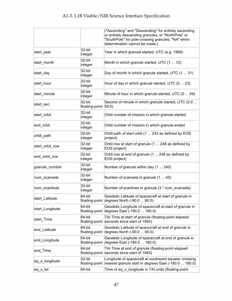
A1-3. L1B Visible/NIR Science Interface Specification
47
("Ascending" and "Descending" for entirely ascending or entirely descending granules, or "NorthPole" or "SouthPole" for pole-crossing granules. "NA" when determination cannot be made.)
start_year 32-bit integer Year in which granule started, UTC (e.g. 1999)
start_month 32-bit integer Month in which granule started, UTC (1 ... 12)
start_day 32-bit integer Day of month in which granule started, UTC (1 ... 31)
start_hour 32-bit integer Hour of day in which granule started, UTC (0 ... 23)
start_minute 32-bit integer Minute of hour in which granule started, UTC (0 ... 59)
start_sec 32-bit floating-point
Second of minute in which granule started, UTC (0.0 ... 59.0)
start_orbit 32-bit integer Orbit number of mission in which granule started
end_orbit 32-bit integer Orbit number of mission in which granule ended
orbit_path 32-bit integer
Orbit path of start orbit (1 ... 233 as defined by EOS project)
start_orbit_row 32-bit integer
Orbit row at start of granule (1 ... 248 as defined by EOS project)
end_orbit_row 32-bit integer
Orbit row at end of granule (1 ... 248 as defined by EOS project)
granule_number 32-bit integer Number of granule within day (1 ... 240)
num_scansets 32-bit integer Number of scansets in granule (1 ... 45)
num_scanlines 32-bit integer Number of scanlines in granule (3 * num_scansets)
start_Latitude 64-bit floating-point
Geodetic Latitude of spacecraft at start of granule in degrees North (-90.0 ... 90.0)
start_Longitude 64-bit floating-point
Geodetic Longitude of spacecraft at start of granule in degrees East (-180.0 ... 180.0)
start_Time 64-bit floating-point
TAI Time at start of granule (floating-point elapsed seconds since start of 1993)
end_Latitude 64-bit floating-point
Geodetic Latitude of spacecraft at end of granule in degrees North (-90.0 ... 90.0)
end_Longitude 64-bit floating-point
Geodetic Longitude of spacecraft at end of granule in degrees East (-180.0 ... 180.0)
end_Time 64-bit floating-point
TAI Time at end of granule (floating-point elapsed seconds since start of 1993)
eq_x_longitude 32-bit floating-point
Longitude of spacecraft at southward equator crossing nearest granule start in degrees East (-180.0 ... 180.0)
eq_x_tai 64-bit Time of eq_x_longitude in TAI units (floating-point
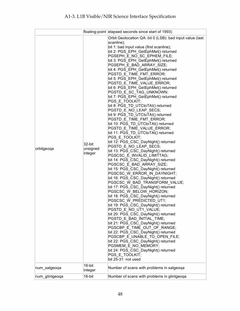
A1-3. L1B Visible/NIR Science Interface Specification
48
floating-point elapsed seconds since start of 1993)
orbitgeoqa 32-bit unsigned integer
Orbit Geolocation QA: bit 0 (LSB): bad input value (last scanline); bit 1: bad input value (first scanline); bit 2: PGS_EPH_GetEphMet() returned PGSEPH_E_NO_SC_EPHEM_FILE; bit 3: PGS_EPH_GetEphMet() returned PGSEPH_E_BAD_ARRAY_SIZE; bit 4: PGS_EPH_GetEphMet() returned PGSTD_E_TIME_FMT_ERROR; bit 5: PGS_EPH_GetEphMet() returned PGSTD_E_TIME_VALUE_ERROR; bit 6: PGS_EPH_GetEphMet() returned PGSTD_E_SC_TAG_UNKNOWN; bit 7: PGS_EPH_GetEphMet() returned PGS_E_TOOLKIT; bit 8: PGS_TD_UTCtoTAI() returned PGSTD_E_NO_LEAP_SECS; bit 9: PGS_TD_UTCtoTAI() returned PGSTD_E_TIME_FMT_ERROR; bit 10: PGS_TD_UTCtoTAI() returned PGSTD_E_TIME_VALUE_ERROR; bit 11: PGS_TD_UTCtoTAI() returned PGS_E_TOOLKIT; bit 12: PGS_CSC_DayNight() returned PGSTD_E_NO_LEAP_SECS; bit 13: PGS_CSC_DayNight() returned PGSCSC_E_INVALID_LIMITTAG; bit 14: PGS_CSC_DayNight() returned PGSCSC_E_BAD_ARRAY_SIZE; bit 15: PGS_CSC_DayNight() returned PGSCSC_W_ERROR_IN_DAYNIGHT; bit 16: PGS_CSC_DayNight() returned PGSCSC_W_BAD_TRANSFORM_VALUE; bit 17: PGS_CSC_DayNight() returned PGSCSC_W_BELOW_HORIZON; bit 18: PGS_CSC_DayNight() returned PGSCSC_W_PREDICTED_UT1; bit 19: PGS_CSC_DayNight() returned PGSTD_E_NO_UT1_VALUE; bit 20: PGS_CSC_DayNight() returned PGSTD_E_BAD_INITIAL_TIME; bit 21: PGS_CSC_DayNight() returned PGSCBP_E_TIME_OUT_OF_RANGE; bit 22: PGS_CSC_DayNight() returned PGSCBP_E_UNABLE_TO_OPEN_FILE; bit 22: PGS_CSC_DayNight() returned PGSMEM_E_NO_MEMORY; bit 24: PGS_CSC_DayNight() returned PGS_E_TOOLKIT; bit 25-31: not used
num_satgeoqa 16-bit integer Number of scans with problems in satgeoqa
num_glintgeoqa 16-bit Number of scans with problems in glintgeoqa
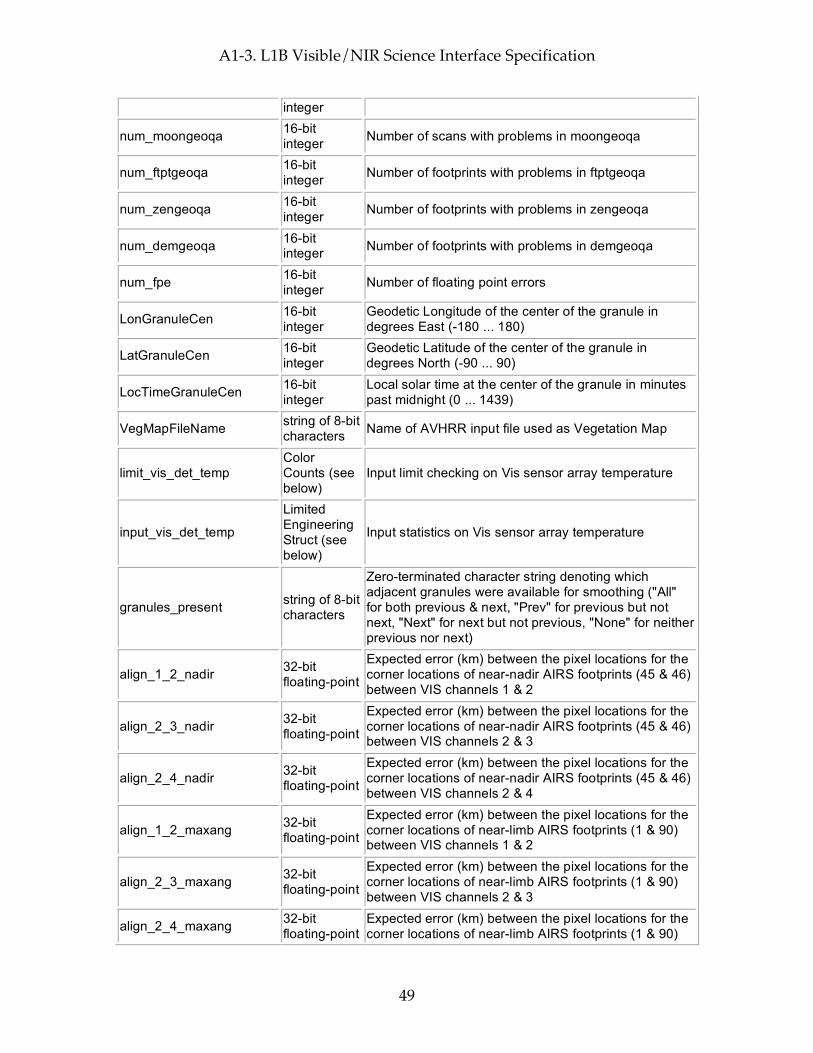
A1-3. L1B Visible/NIR Science Interface Specification
49
integer
num_moongeoqa 16-bit integer Number of scans with problems in moongeoqa
num_ftptgeoqa 16-bit integer Number of footprints with problems in ftptgeoqa
num_zengeoqa 16-bit integer Number of footprints with problems in zengeoqa
num_demgeoqa 16-bit integer Number of footprints with problems in demgeoqa
num_fpe 16-bit integer Number of floating point errors
LonGranuleCen 16-bit integer
Geodetic Longitude of the center of the granule in degrees East (-180 ... 180)
LatGranuleCen 16-bit integer
Geodetic Latitude of the center of the granule in degrees North (-90 ... 90)
LocTimeGranuleCen 16-bit integer
Local solar time at the center of the granule in minutes past midnight (0 ... 1439)
VegMapFileName string of 8-bit characters Name of AVHRR input file used as Vegetation Map
limit_vis_det_temp Color Counts (see below)
Input limit checking on Vis sensor array temperature
input_vis_det_temp
Limited Engineering Struct (see below)
Input statistics on Vis sensor array temperature
granules_present string of 8-bit characters
Zero-terminated character string denoting which adjacent granules were available for smoothing ("All" for both previous & next, "Prev" for previous but not next, "Next" for next but not previous, "None" for neither previous nor next)
align_1_2_nadir 32-bit floating-point
Expected error (km) between the pixel locations for the corner locations of near-nadir AIRS footprints (45 & 46) between VIS channels 1 & 2
align_2_3_nadir 32-bit floating-point
Expected error (km) between the pixel locations for the corner locations of near-nadir AIRS footprints (45 & 46) between VIS channels 2 & 3
align_2_4_nadir 32-bit floating-point
Expected error (km) between the pixel locations for the corner locations of near-nadir AIRS footprints (45 & 46) between VIS channels 2 & 4
align_1_2_maxang 32-bit floating-point
Expected error (km) between the pixel locations for the corner locations of near-limb AIRS footprints (1 & 90) between VIS channels 1 & 2
align_2_3_maxang 32-bit floating-point
Expected error (km) between the pixel locations for the corner locations of near-limb AIRS footprints (1 & 90) between VIS channels 2 & 3
align_2_4_maxang 32-bit floating-point
Expected error (km) between the pixel locations for the corner locations of near-limb AIRS footprints (1 & 90)
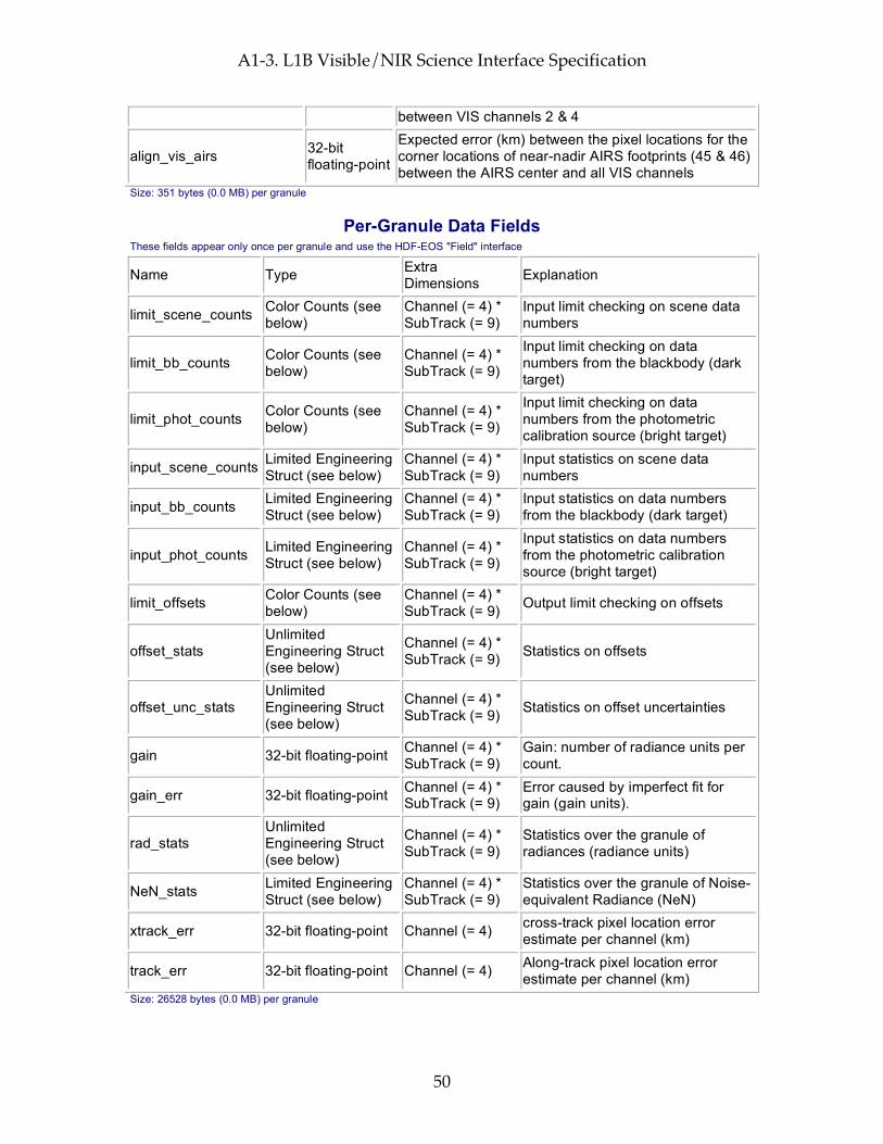
A1-3. L1B Visible/NIR Science Interface Specification
50
between VIS channels 2 & 4
align_vis_airs 32-bit floating-point
Expected error (km) between the pixel locations for the corner locations of near-nadir AIRS footprints (45 & 46) between the AIRS center and all VIS channels
Size: 351 bytes (0.0 MB) per granule
Per-Granule Data Fields These fields appear only once per granule and use the HDF-EOS "Field" interface
Name Type Extra Dimensions Explanation
limit_scene_counts Color Counts (see below)
Channel (= 4) * SubTrack (= 9)
Input limit checking on scene data numbers
limit_bb_counts Color Counts (see below)
Channel (= 4) * SubTrack (= 9)
Input limit checking on data numbers from the blackbody (dark target)
limit_phot_counts Color Counts (see below)
Channel (= 4) * SubTrack (= 9)
Input limit checking on data numbers from the photometric calibration source (bright target)
input_scene_counts Limited Engineering Struct (see below)
Channel (= 4) * SubTrack (= 9)
Input statistics on scene data numbers
input_bb_counts Limited Engineering Struct (see below)
Channel (= 4) * SubTrack (= 9)
Input statistics on data numbers from the blackbody (dark target)
input_phot_counts Limited Engineering Struct (see below)
Channel (= 4) * SubTrack (= 9)
Input statistics on data numbers from the photometric calibration source (bright target)
limit_offsets Color Counts (see below)
Channel (= 4) * SubTrack (= 9) Output limit checking on offsets
offset_stats Unlimited Engineering Struct (see below)
Channel (= 4) * SubTrack (= 9) Statistics on offsets
offset_unc_stats Unlimited Engineering Struct (see below)
Channel (= 4) * SubTrack (= 9) Statistics on offset uncertainties
gain 32-bit floating-point Channel (= 4) * SubTrack (= 9)
Gain: number of radiance units per count.
gain_err 32-bit floating-point Channel (= 4) * SubTrack (= 9)
Error caused by imperfect fit for gain (gain units).
rad_stats Unlimited Engineering Struct (see below)
Channel (= 4) * SubTrack (= 9)
Statistics over the granule of radiances (radiance units)
NeN_stats Limited Engineering Struct (see below)
Channel (= 4) * SubTrack (= 9)
Statistics over the granule of Noise-equivalent Radiance (NeN)
xtrack_err 32-bit floating-point Channel (= 4) cross-track pixel location error estimate per channel (km)
track_err 32-bit floating-point Channel (= 4) Along-track pixel location error estimate per channel (km)
Size: 26528 bytes (0.0 MB) per granule

A1-3. L1B Visible/NIR Science Interface Specification
51
Along-Track Data Fields These fields appear once per scanline (GeoTrack times)
Name Type Extra Dimensions Explanation
offset 32-bit floating-point
Channel (= 4) * SubTrack (= 9)
Offset: number of counts expected for no radiance at time nadirTAI
offset_err 32-bit floating-point
Channel (= 4) * SubTrack (= 9)
Error caused by imperfect fit for offset (radiance units)
NeN 32-bit floating-point
Channel (= 4) * SubTrack (= 9)
Noise-equivalent Radiance (radiance units)
satheight 32-bit floating-point
None Satellite altitude at nadirTAI in km above reference ellipsoid (e.g. 725.2)
satroll 32-bit floating-point
None
Satellite attitude roll angle at nadirTAI (-180.0 ... 180.0 angle about the +x (roll) ORB axis, +x axis is positively oriented in the direction of orbital flight completing an orthogonal triad with y and z.)
satpitch 32-bit floating-point
None
Satellite attitude pitch angle at nadirTAI (-180.0 ... 180.0 angle about +y (pitch) ORB axis. +y axis is oriented normal to the orbit plane with the positive sense opposite to that of the orbit's angular momentum vector H.)
satyaw 32-bit floating-point
None
Satellite attitude yaw angle at nadirTAI (-180.0 ... 180.0 angle about +z (yaw) axis. +z axis is positively oriented Earthward parallel to the satellite radius vector R from the spacecraft center of mass to the center of the Earth.)
satgeoqa 32-bit unsigned integer
None
Satellite Geolocation QA flags: bit 0 (LSB): bad input value; bit 1: PGS_TD_TAItoUTC() returned PGSTD_E_NO_LEAP_SECS; bit 2: PGS_TD_TAItoUTC() returned PGS_E_TOOLKIT; bit 3: PGS_EPH_EphemAttit() returned PGSEPH_W_BAD_EPHEM_VALUE; bit 4: PGS_EPH_EphemAttit() returned PGSEPH_E_BAD_EPHEM_FILE_HDR; bit 5: PGS_EPH_EphemAttit() returned PGSEPH_E_NO_SC_EPHEM_FILE; bit 6: PGS_EPH_EphemAttit() returned PGSEPH_E_NO_DATA_REQUESTED; bit 7: PGS_EPH_EphemAttit() returned PGSTD_E_SC_TAG_UNKNOWN; bit 8: PGS_EPH_EphemAttit() returned PGSEPH_E_BAD_ARRAY_SIZE; bit 9: PGS_EPH_EphemAttit() returned

A1-3. L1B Visible/NIR Science Interface Specification
52
PGSTD_E_TIME_FMT_ERROR; bit 10: PGS_EPH_EphemAttit() returned PGSTD_E_TIME_VALUE_ERROR; bit 11: PGS_EPH_EphemAttit() returned PGSTD_E_NO_LEAP_SECS; bit 12: PGS_EPH_EphemAttit() returned PGS_E_TOOLKIT; bit 13: PGS_CSC_ECItoECR() returned PGSCSC_W_BAD_TRANSFORM_VALUE; bit 14: PGS_CSC_ECItoECR() returned PGSCSC_E_BAD_ARRAY_SIZE; bit 15: PGS_CSC_ECItoECR() returned PGSTD_E_NO_LEAP_SECS; bit 16: PGS_CSC_ECItoECR() returned PGSTD_E_TIME_FMT_ERROR; bit 17: PGS_CSC_ECItoECR() returned PGSTD_E_TIME_VALUE_ERROR; bit 18: unused (set to zero); bit 19: PGS_CSC_ECItoECR() returned PGSTD_E_NO_UT1_VALUE; bit 20: PGS_CSC_ECItoECR() returned PGS_E_TOOLKIT; bit 21: PGS_CSC_ECRtoGEO() returned PGSCSC_W_TOO_MANY_ITERS; bit 22: PGS_CSC_ECRtoGEO() returned PGSCSC_W_INVALID_ALTITUDE; bit 23: PGS_CSC_ECRtoGEO() returned PGSCSC_W_SPHERE_BODY; bit 24: PGS_CSC_ECRtoGEO() returned PGSCSC_W_LARGE_FLATTENING; bit 25: PGS_CSC_ECRtoGEO() returned PGSCSC_W_DEFAULT_EARTH_MODEL; bit 26: PGS_CSC_ECRtoGEO() returned PGSCSC_E_BAD_EARTH_MODEL; bit 27: PGS_CSC_ECRtoGEO() returned PGS_E_TOOLKIT; bit 28-31: not used
glintgeoqa 16-bit unsigned integer
None
Glint Geolocation QA flags: bit 0 (LSB): bad input value; bit 1: glint location in Earth's shadow; bit 2: glint calculation not converging; bit 3: glint location sun vs. satellite zenith mismatch; bit 4: glint location sun vs. satellite azimuth mismatch; bit 5: bad glint location; bit 6: PGS_CSC_ZenithAzimuth() returned any 'W' class return code; bit 7: PGS_CSC_ZenithAzimuth() returned any 'E' class return code; bit 8: PGS_CBP_Earth_CB_Vector() returned returned any 'W' class return code; bit 9: PGS_CBP_Earth_CB_Vector() returned returned any 'E' class return code; bit 10: PGS_CSC_ECItoECR() returned any 'W' class return code except PGSCSC_W_PREDICTED_UT1 (for Glint);

A1-3. L1B Visible/NIR Science Interface Specification
53
bit 11: PGS_CSC_ECItoECR() returned any 'E' class return code (for Glint); bit 12: PGS_CSC_ECRtoGEO() returned any 'W' class return code (for Glint); bit 13: PGS_CSC_ECRtoGEO() returned any 'E' class return code (for Glint); bit 14: PGS_CSC_ECItoECR() returned any 'W' class return code except PGSCSC_W_PREDICTED_UT1 ; bit 15: PGS_CSC_ECItoECR() returned any 'E' class return code
moongeoqa 16-bit unsigned integer
None
Moon Geolocation QA flags: bit 0 (LSB): bad input value; bit 1: PGS_TD_TAItoUTC() returned PGSTD_E_NO_LEAP_SECS; bit 2: PGS_TD_TAItoUTC() returned PGS_E_TOOLKIT; bit 3: PGS_CBP_Sat_CB_Vector() returned PGSCSC_W_BELOW_SURFACE; bit 4: PGS_CBP_Sat_CB_Vector() returned PGSCBP_W_BAD_CB_VECTOR; bit 5: PGS_CBP_Sat_CB_Vector() returned PGSCBP_E_BAD_ARRAY_SIZE; bit 6: PGS_CBP_Sat_CB_Vector() returned PGSCBP_E_INVALID_CB_ID; bit 7: PGS_CBP_Sat_CB_Vector() returned PGSMEM_E_NO_MEMORY; bit 8: PGS_CBP_Sat_CB_Vector() returned PGSCBP_E_UNABLE_TO_OPEN_FILE; bit 9: PGS_CBP_Sat_CB_Vector() returned PGSTD_E_BAD_INITIAL_TIME; bit 10: PGS_CBP_Sat_CB_Vector() returned PGSCBP_E_TIME_OUT_OF_RANGE; bit 11: PGS_CBP_Sat_CB_Vector() returned PGSTD_E_SC_TAG_UNKNOWN; bit 12: PGS_CBP_Sat_CB_Vector() returned PGSEPH_E_BAD_EPHEM_FILE_HDR; bit 13: PGS_CBP_Sat_CB_Vector() returned PGSEPH_E_NO_SC_EPHEM_FILE; bit 14: PGS_CBP_Sat_CB_Vector() returned PGS_E_TOOLKIT; bit 15: not used
nadirTAI 64-bit floating-point
None
TAI time at which instrument is nominally looking directly down. (between footprints 15 & 16 for AMSU or between footprints 45 & 46 for AIRS/Vis & HSB) (floating-point elapsed seconds since start of 1993)
sat_lat 64-bit floating-point
None Satellite geodetic latitude in degrees North (-90.0 ... 90.0)
sat_lon 64-bit floating-point
None Satellite geodetic longitude in degrees East (-180.0 ... 180.0)
scan_node_type 8-bit integer None 'A' for ascending, 'D' for descending, 'N' for North-
Polar, 'S' for South-Polar
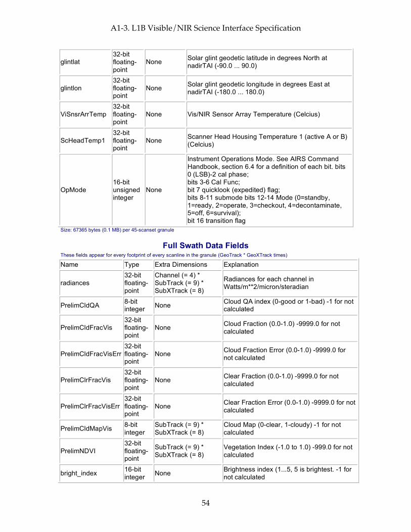
A1-3. L1B Visible/NIR Science Interface Specification
54
glintlat 32-bit floating-point
None Solar glint geodetic latitude in degrees North at nadirTAI (-90.0 ... 90.0)
glintlon 32-bit floating-point
None Solar glint geodetic longitude in degrees East at nadirTAI (-180.0 ... 180.0)
ViSnsrArrTemp 32-bit floating-point
None Vis/NIR Sensor Array Temperature (Celcius)
ScHeadTemp1 32-bit floating-point
None Scanner Head Housing Temperature 1 (active A or B) (Celcius)
OpMode 16-bit unsigned integer
None
Instrument Operations Mode. See AIRS Command Handbook, section 6.4 for a definition of each bit. bits 0 (LSB)-2 cal phase; bits 3-6 Cal Func; bit 7 quicklook (expedited) flag; bits 8-11 submode bits 12-14 Mode (0=standby, 1=ready, 2=operate, 3=checkout, 4=decontaminate, 5=off, 6=survival); bit 16 transition flag
Size: 67365 bytes (0.1 MB) per 45-scanset granule
Full Swath Data Fields These fields appear for every footprint of every scanline in the granule (GeoTrack * GeoXTrack times)
Name Type Extra Dimensions Explanation
radiances 32-bit floating-point
Channel (= 4) * SubTrack (= 9) * SubXTrack (= 8)
Radiances for each channel in Watts/m**2/micron/steradian
PrelimCldQA 8-bit integer None Cloud QA index (0-good or 1-bad) -1 for not
calculated
PrelimCldFracVis 32-bit floating-point
None Cloud Fraction (0.0-1.0) -9999.0 for not calculated
PrelimCldFracVisErr 32-bit floating-point
None Cloud Fraction Error (0.0-1.0) -9999.0 for not calculated
PrelimClrFracVis 32-bit floating-point
None Clear Fraction (0.0-1.0) -9999.0 for not calculated
PrelimClrFracVisErr 32-bit floating-point
None Clear Fraction Error (0.0-1.0) -9999.0 for not calculated
PrelimCldMapVis 8-bit integer
SubTrack (= 9) * SubXTrack (= 8)
Cloud Map (0-clear, 1-cloudy) -1 for not calculated
PrelimNDVI 32-bit floating-point
SubTrack (= 9) * SubXTrack (= 8)
Vegetation Index (-1.0 to 1.0) -999.0 for not calculated
bright_index 16-bit integer None Brightness index (1...5, 5 is brightest. -1 for
not calculated

A1-3. L1B Visible/NIR Science Interface Specification
55
inhomo_index 16-bit integer None
Inhomgeneity index (0...64, 1st digit NDVI-Dev, 2nd digit Ch1-Dev, -9999 for not calculated
scanang 32-bit floating-point
None
Scanning angle of AIRS instrument with respect to the AIRS Instrument for this footprint (-180.0 ... 180.0, negative at start of scan, 0 at nadir)
ftptgeoqa 32-bit unsigned integer
None
Footprint Geolocation QA flags: bit 0 (LSB): bad input value; bit 1: PGS_TD_TAItoUTC() returned PGSTD_E_NO_LEAP_SECS; bit 2: PGS_TD_TAItoUTC() returned PGS_E_TOOLKIT; bit 3: PGS_CSC_GetFOV_Pixel() returned PGSCSC_W_MISS_EARTH; bit 4: PGS_CSC_GetFOV_Pixel() returned PGSTD_E_SC_TAG_UNKNOWN; bit 5: PGS_CSC_GetFOV_Pixel() returned PGSCSC_W_ZERO_PIXEL_VECTOR; bit 6: PGS_CSC_GetFOV_Pixel() returned PGSCSC_W_BAD_EPH_FOR_PIXEL; bit 7: PGS_CSC_GetFOV_Pixel() returned PGSCSC_W_INSTRUMENT_OFF_BOARD; bit 8: PGS_CSC_GetFOV_Pixel() returned PGSCSC_W_BAD_ACCURACY_FLAG; bit 9: PGS_CSC_GetFOV_Pixel() returned PGSCSC_E_BAD_ARRAY_SIZE; bit 10: PGS_CSC_GetFOV_Pixel() returned PGSCSC_W_DEFAULT_EARTH_MODEL; bit 11: PGS_CSC_GetFOV_Pixel() returned PGSCSC_W_DATA_FILE_MISSING; bit 12: PGS_CSC_GetFOV_Pixel() returned PGSCSC_E_NEG_OR_ZERO_RAD; bit 13: PGS_CSC_GetFOV_Pixel() returned PGSMEM_E_NO_MEMORY; bit 14: PGS_CSC_GetFOV_Pixel() returned PGSTD_E_NO_LEAP_SECS; bit 15: PGS_CSC_GetFOV_Pixel() returned PGSTD_E_TIME_FMT_ERROR; bit 16: PGS_CSC_GetFOV_Pixel() returned PGSTD_E_TIME_VALUE_ERROR; bit 17: PGS_CSC_GetFOV_Pixel() returned PGSCSC_W_PREDICTED_UT1; bit 18: PGS_CSC_GetFOV_Pixel() returned PGSTD_E_NO_UT1_VALUE; bit 19: PGS_CSC_GetFOV_Pixel() returned PGS_E_TOOLKIT; bit 20: PGS_CSC_GetFOV_Pixel() returned PGSEPH_E_BAD_EPHEM_FILE_HDR; bit 21: PGS_CSC_GetFOV_Pixel() returned PGSEPH_E_NO_SC_EPHEM_FILE; bit 22-31: not used
zengeoqa 16-bit unsigned None Satellite zenith Geolocation QA flags: bit 0
(LSB): (Spacecraft) bad input value;
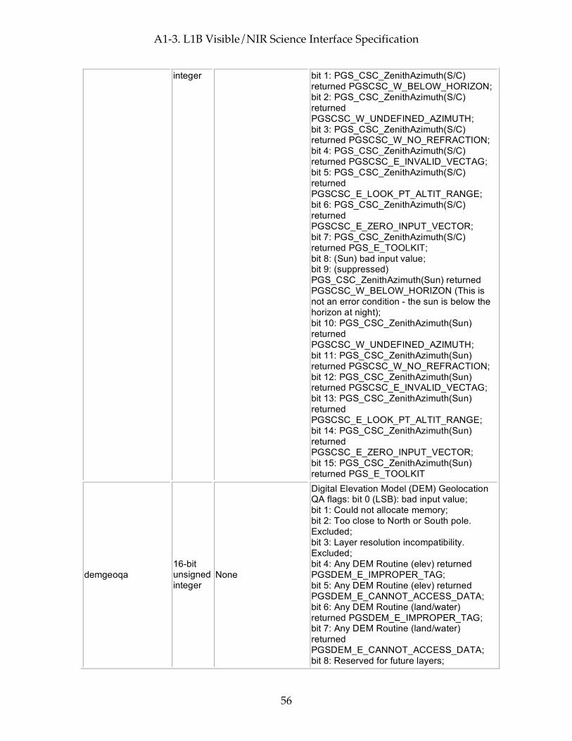
A1-3. L1B Visible/NIR Science Interface Specification
56
integer bit 1: PGS_CSC_ZenithAzimuth(S/C) returned PGSCSC_W_BELOW_HORIZON; bit 2: PGS_CSC_ZenithAzimuth(S/C) returned PGSCSC_W_UNDEFINED_AZIMUTH; bit 3: PGS_CSC_ZenithAzimuth(S/C) returned PGSCSC_W_NO_REFRACTION; bit 4: PGS_CSC_ZenithAzimuth(S/C) returned PGSCSC_E_INVALID_VECTAG; bit 5: PGS_CSC_ZenithAzimuth(S/C) returned PGSCSC_E_LOOK_PT_ALTIT_RANGE; bit 6: PGS_CSC_ZenithAzimuth(S/C) returned PGSCSC_E_ZERO_INPUT_VECTOR; bit 7: PGS_CSC_ZenithAzimuth(S/C) returned PGS_E_TOOLKIT; bit 8: (Sun) bad input value; bit 9: (suppressed) PGS_CSC_ZenithAzimuth(Sun) returned PGSCSC_W_BELOW_HORIZON (This is not an error condition - the sun is below the horizon at night); bit 10: PGS_CSC_ZenithAzimuth(Sun) returned PGSCSC_W_UNDEFINED_AZIMUTH; bit 11: PGS_CSC_ZenithAzimuth(Sun) returned PGSCSC_W_NO_REFRACTION; bit 12: PGS_CSC_ZenithAzimuth(Sun) returned PGSCSC_E_INVALID_VECTAG; bit 13: PGS_CSC_ZenithAzimuth(Sun) returned PGSCSC_E_LOOK_PT_ALTIT_RANGE; bit 14: PGS_CSC_ZenithAzimuth(Sun) returned PGSCSC_E_ZERO_INPUT_VECTOR; bit 15: PGS_CSC_ZenithAzimuth(Sun) returned PGS_E_TOOLKIT
demgeoqa 16-bit unsigned integer
None
Digital Elevation Model (DEM) Geolocation QA flags: bit 0 (LSB): bad input value; bit 1: Could not allocate memory; bit 2: Too close to North or South pole. Excluded; bit 3: Layer resolution incompatibility. Excluded; bit 4: Any DEM Routine (elev) returned PGSDEM_E_IMPROPER_TAG; bit 5: Any DEM Routine (elev) returned PGSDEM_E_CANNOT_ACCESS_DATA; bit 6: Any DEM Routine (land/water) returned PGSDEM_E_IMPROPER_TAG; bit 7: Any DEM Routine (land/water) returned PGSDEM_E_CANNOT_ACCESS_DATA; bit 8: Reserved for future layers;
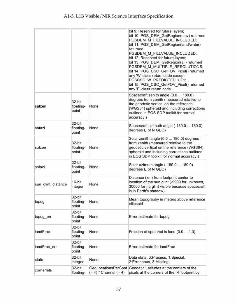
A1-3. L1B Visible/NIR Science Interface Specification
57
bit 9: Reserved for future layers; bit 10: PGS_DEM_GetRegion(elev) returned PGSDEM_M_FILLVALUE_INCLUDED; bit 11: PGS_DEM_GetRegion(land/water) returned PGSDEM_M_FILLVALUE_INCLUDED; bit 12: Reserved for future layers; bit 13: PGS_DEM_GetRegion(all) returned PGSDEM_M_MULTIPLE_RESOLUTIONS; bit 14: PGS_CSC_GetFOV_Pixel() returned any 'W' class return code except PGSCSC_W_PREDICTED_UT1; bit 15: PGS_CSC_GetFOV_Pixel() returned any 'E' class return code
satzen 32-bit floating-point
None
Spacecraft zenith angle (0.0 ... 180.0) degrees from zenith (measured relative to the geodetic vertical on the reference (WGS84) spheroid and including corrections outlined in EOS SDP toolkit for normal accuracy.)
satazi 32-bit floating-point
None Spacecraft azimuth angle (-180.0 ... 180.0) degrees E of N GEO)
solzen 32-bit floating-point
None
Solar zenith angle (0.0 ... 180.0) degrees from zenith (measured relative to the geodetic vertical on the reference (WGS84) spheroid and including corrections outlined in EOS SDP toolkit for normal accuracy.)
solazi 32-bit floating-point
None Solar azimuth angle (-180.0 ... 180.0) degrees E of N GEO)
sun_glint_distance 16-bit integer None
Distance (km) from footprint center to location of the sun glint (-9999 for unknown, 30000 for no glint visible because spacecraft is in Earth's shadow)
topog 32-bit floating-point
None Mean topography in meters above reference ellipsoid
topog_err 32-bit floating-point
None Error estimate for topog
landFrac 32-bit floating-point
None Fraction of spot that is land (0.0 ... 1.0)
landFrac_err 32-bit floating-point
None Error estimate for landFrac
state 32-bit integer None Data state: 0:Process, 1:Special,
2:Erroneous, 3:Missing
cornerlats 32-bit floating-
GeoLocationsPerSpot (= 4) * Channel (= 4)
Geodetic Latitudes at the centers of the pixels at the corners of the IR footprint by
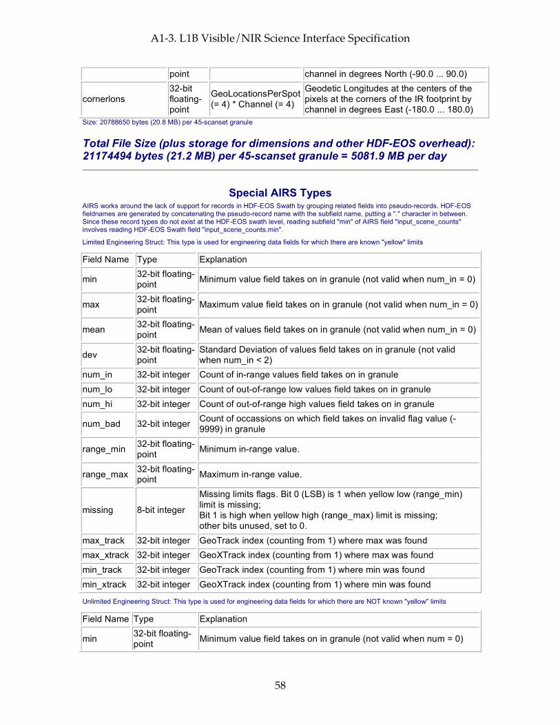
A1-3. L1B Visible/NIR Science Interface Specification
58
point channel in degrees North (-90.0 ... 90.0)
cornerlons 32-bit floating-point
GeoLocationsPerSpot (= 4) * Channel (= 4)
Geodetic Longitudes at the centers of the pixels at the corners of the IR footprint by channel in degrees East (-180.0 ... 180.0)
Size: 20788650 bytes (20.8 MB) per 45-scanset granule
Total File Size (plus storage for dimensions and other HDF-EOS overhead): 21174494 bytes (21.2 MB) per 45-scanset granule = 5081.9 MB per day
Special AIRS Types AIRS works around the lack of support for records in HDF-EOS Swath by grouping related fields into pseudo-records. HDF-EOS fieldnames are generated by concatenating the pseudo-record name with the subfield name, putting a "." character in between. Since these record types do not exist at the HDF-EOS swath level, reading subfield "min" of AIRS field "input_scene_counts" involves reading HDF-EOS Swath field "input_scene_counts.min".
Limited Engineering Struct: This type is used for engineering data fields for which there are known "yellow" limits
Field Name Type Explanation
min 32-bit floating-point Minimum value field takes on in granule (not valid when num_in = 0)
max 32-bit floating-point Maximum value field takes on in granule (not valid when num_in = 0)
mean 32-bit floating-point Mean of values field takes on in granule (not valid when num_in = 0)
dev 32-bit floating-point
Standard Deviation of values field takes on in granule (not valid when num_in < 2)
num_in 32-bit integer Count of in-range values field takes on in granule num_lo 32-bit integer Count of out-of-range low values field takes on in granule num_hi 32-bit integer Count of out-of-range high values field takes on in granule
num_bad 32-bit integer Count of occassions on which field takes on invalid flag value (-9999) in granule
range_min 32-bit floating-point Minimum in-range value.
range_max 32-bit floating-point Maximum in-range value.
missing 8-bit integer
Missing limits flags. Bit 0 (LSB) is 1 when yellow low (range_min) limit is missing; Bit 1 is high when yellow high (range_max) limit is missing; other bits unused, set to 0.
max_track 32-bit integer GeoTrack index (counting from 1) where max was found max_xtrack 32-bit integer GeoXTrack index (counting from 1) where max was found min_track 32-bit integer GeoTrack index (counting from 1) where min was found min_xtrack 32-bit integer GeoXTrack index (counting from 1) where min was found
Unlimited Engineering Struct: This type is used for engineering data fields for which there are NOT known "yellow" limits
Field Name Type Explanation
min 32-bit floating-point Minimum value field takes on in granule (not valid when num = 0)
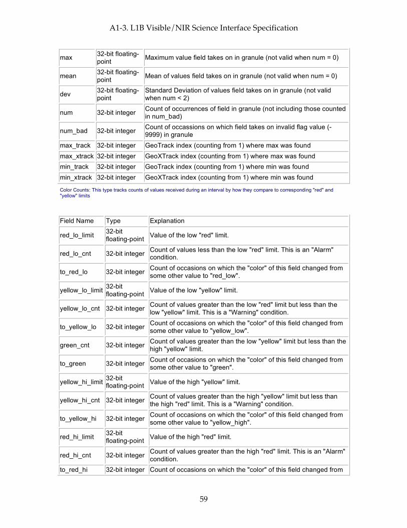
A1-3. L1B Visible/NIR Science Interface Specification
59
max 32-bit floating-point Maximum value field takes on in granule (not valid when num = 0)
mean 32-bit floating-point Mean of values field takes on in granule (not valid when num = 0)
dev 32-bit floating-point
Standard Deviation of values field takes on in granule (not valid when num < 2)
num 32-bit integer Count of occurrences of field in granule (not including those counted in num_bad)
num_bad 32-bit integer Count of occassions on which field takes on invalid flag value (-9999) in granule
max_track 32-bit integer GeoTrack index (counting from 1) where max was found max_xtrack 32-bit integer GeoXTrack index (counting from 1) where max was found min_track 32-bit integer GeoTrack index (counting from 1) where min was found min_xtrack 32-bit integer GeoXTrack index (counting from 1) where min was found
Color Counts: This type tracks counts of values received during an interval by how they compare to corresponding "red" and "yellow" limits
Field Name Type Explanation
red_lo_limit 32-bit floating-point Value of the low "red" limit.
red_lo_cnt 32-bit integer Count of values less than the low "red" limit. This is an "Alarm" condition.
to_red_lo 32-bit integer Count of occasions on which the "color" of this field changed from some other value to "red_low".
yellow_lo_limit 32-bit floating-point Value of the low "yellow" limit.
yellow_lo_cnt 32-bit integer Count of values greater than the low "red" limit but less than the low "yellow" limit. This is a "Warning" condition.
to_yellow_lo 32-bit integer Count of occasions on which the "color" of this field changed from some other value to "yellow_low".
green_cnt 32-bit integer Count of values greater than the low "yellow" limit but less than the high "yellow" limit.
to_green 32-bit integer Count of occasions on which the "color" of this field changed from some other value to "green".
yellow_hi_limit 32-bit floating-point Value of the high "yellow" limit.
yellow_hi_cnt 32-bit integer Count of values greater than the high "yellow" limit but less than the high "red" limit. This is a "Warning" condition.
to_yellow_hi 32-bit integer Count of occasions on which the "color" of this field changed from some other value to "yellow_high".
red_hi_limit 32-bit floating-point Value of the high "red" limit.
red_hi_cnt 32-bit integer Count of values greater than the high "red" limit. This is an "Alarm" condition.
to_red_hi 32-bit integer Count of occasions on which the "color" of this field changed from

A1-3. L1B Visible/NIR Science Interface Specification
60
some other value to "red_high".
missing 8-bit integer
Missing limits flags. Bit 0 (LSB) is 1 when yellow low limit (yellow_lo_limit) is missing; Bit 1 is high when yellow high limit is missing; Bit 2 is 1 when red low limit is missing; Bit 3 is 1 when red high limit is missing; Other bits unused set to 0.
This page intentionally left blank.
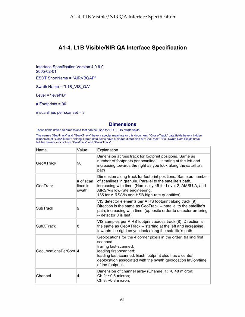
A1-4. L1B Visible/NIR QA Interface Specification
61
A1-4. L1B Visible/NIR QA Interface Specification
Interface Specification Version 4.0.9.0 2005-02-01
ESDT ShortName = "AIRVBQAP"
Swath Name = "L1B_VIS_QA"
Level = "level1B"
# Footprints = 90
# scanlines per scanset = 3
Dimensions These fields define all dimensions that can be used for HDF-EOS swath fields.
The names "GeoTrack" and "GeoXTrack" have a special meaning for this document: "Cross-Track" data fields have a hidden dimension of "GeoXTrack"; "Along-Track" data fields have a hidden dimension of "GeoTrack"; "Full Swath Data Fields have hidden dimensions of both "GeoTrack" and "GeoXTrack".
Name Value Explanation
GeoXTrack 90
Dimension across track for footprint positions. Same as number of footprints per scanline. -- starting at the left and increasing towards the right as you look along the satellite's path
GeoTrack # of scan lines in swath
Dimension along track for footprint positions. Same as number of scanlines in granule. Parallel to the satellite's path, increasing with time. (Nominally 45 for Level-2, AMSU-A, and AIRS/Vis low-rate engineering; 135 for AIRS/Vis and HSB high-rate quantities)
SubTrack 9
VIS detector elements per AIRS footprint along track (9). Direction is the same as GeoTrack -- parallel to the satellite's path, increasing with time. (opposite order to detector ordering -- detector 0 is last)
SubXTrack 8 VIS samples per AIRS footprint across track (8). Direction is the same as GeoXTrack -- starting at the left and increasing towards the right as you look along the satellite's path
GeoLocationsPerSpot 4
Geolocations for the 4 corner pixels in the order: trailing first scanned; trailing last-scanned; leading first-scanned; leading last-scanned. Each footprint also has a central geolocation associated with the swath geolocation lat/lon/time of the footprint.
Channel 4 Dimension of channel array (Channel 1: ~0.40 micron; Ch 2: ~0.6 micron; Ch 3: ~0.8 micron;
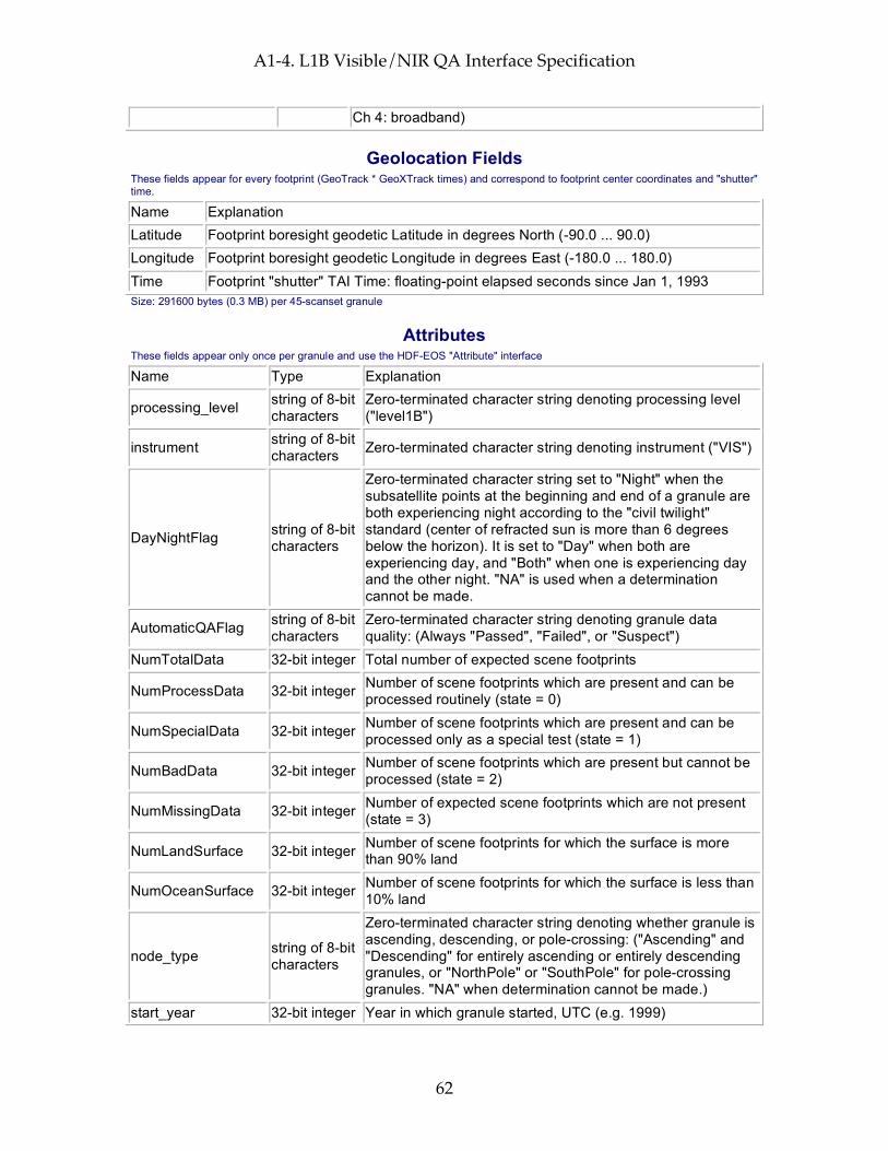
A1-4. L1B Visible/NIR QA Interface Specification
62
Ch 4: broadband)
Geolocation Fields These fields appear for every footprint (GeoTrack * GeoXTrack times) and correspond to footprint center coordinates and "shutter" time.
Name Explanation Latitude Footprint boresight geodetic Latitude in degrees North (-90.0 ... 90.0) Longitude Footprint boresight geodetic Longitude in degrees East (-180.0 ... 180.0) Time Footprint "shutter" TAI Time: floating-point elapsed seconds since Jan 1, 1993 Size: 291600 bytes (0.3 MB) per 45-scanset granule
Attributes These fields appear only once per granule and use the HDF-EOS "Attribute" interface
Name Type Explanation
processing_level string of 8-bit characters
Zero-terminated character string denoting processing level ("level1B")
instrument string of 8-bit characters Zero-terminated character string denoting instrument ("VIS")
DayNightFlag string of 8-bit characters
Zero-terminated character string set to "Night" when the subsatellite points at the beginning and end of a granule are both experiencing night according to the "civil twilight" standard (center of refracted sun is more than 6 degrees below the horizon). It is set to "Day" when both are experiencing day, and "Both" when one is experiencing day and the other night. "NA" is used when a determination cannot be made.
AutomaticQAFlag string of 8-bit characters
Zero-terminated character string denoting granule data quality: (Always "Passed", "Failed", or "Suspect")
NumTotalData 32-bit integer Total number of expected scene footprints
NumProcessData 32-bit integer Number of scene footprints which are present and can be processed routinely (state = 0)
NumSpecialData 32-bit integer Number of scene footprints which are present and can be processed only as a special test (state = 1)
NumBadData 32-bit integer Number of scene footprints which are present but cannot be processed (state = 2)
NumMissingData 32-bit integer Number of expected scene footprints which are not present (state = 3)
NumLandSurface 32-bit integer Number of scene footprints for which the surface is more than 90% land
NumOceanSurface 32-bit integer Number of scene footprints for which the surface is less than 10% land
node_type string of 8-bit characters
Zero-terminated character string denoting whether granule is ascending, descending, or pole-crossing: ("Ascending" and "Descending" for entirely ascending or entirely descending granules, or "NorthPole" or "SouthPole" for pole-crossing granules. "NA" when determination cannot be made.)
start_year 32-bit integer Year in which granule started, UTC (e.g. 1999)

A1-4. L1B Visible/NIR QA Interface Specification
63
start_month 32-bit integer Month in which granule started, UTC (1 ... 12) start_day 32-bit integer Day of month in which granule started, UTC (1 ... 31) start_hour 32-bit integer Hour of day in which granule started, UTC (0 ... 23) start_minute 32-bit integer Minute of hour in which granule started, UTC (0 ... 59)
start_sec 32-bit floating-point Second of minute in which granule started, UTC (0.0 ... 59.0)
start_orbit 32-bit integer Orbit number of mission in which granule started end_orbit 32-bit integer Orbit number of mission in which granule ended orbit_path 32-bit integer Orbit path of start orbit (1 ... 233 as defined by EOS project)
start_orbit_row 32-bit integer Orbit row at start of granule (1 ... 248 as defined by EOS project)
end_orbit_row 32-bit integer Orbit row at end of granule (1 ... 248 as defined by EOS project)
granule_number 32-bit integer Number of granule within day (1 ... 240) num_scansets 32-bit integer Number of scansets in granule (1 ... 45) num_scanlines 32-bit integer Number of scanlines in granule (3 * num_scansets)
start_Latitude 64-bit floating-point
Geodetic Latitude of spacecraft at start of granule in degrees North (-90.0 ... 90.0)
start_Longitude 64-bit floating-point
Geodetic Longitude of spacecraft at start of granule in degrees East (-180.0 ... 180.0)
start_Time 64-bit floating-point
TAI Time at start of granule (floating-point elapsed seconds since start of 1993)
end_Latitude 64-bit floating-point
Geodetic Latitude of spacecraft at end of granule in degrees North (-90.0 ... 90.0)
end_Longitude 64-bit floating-point
Geodetic Longitude of spacecraft at end of granule in degrees East (-180.0 ... 180.0)
end_Time 64-bit floating-point
TAI Time at end of granule (floating-point elapsed seconds since start of 1993)
eq_x_longitude 32-bit floating-point
Longitude of spacecraft at southward equator crossing nearest granule start in degrees East (-180.0 ... 180.0)
eq_x_tai 64-bit floating-point
Time of eq_x_longitude in TAI units (floating-point elapsed seconds since start of 1993)
orbitgeoqa 32-bit unsigned integer
Orbit Geolocation QA: bit 0 (LSB): bad input value (last scanline); bit 1: bad input value (first scanline); bit 2: PGS_EPH_GetEphMet() returned PGSEPH_E_NO_SC_EPHEM_FILE; bit 3: PGS_EPH_GetEphMet() returned PGSEPH_E_BAD_ARRAY_SIZE; bit 4: PGS_EPH_GetEphMet() returned PGSTD_E_TIME_FMT_ERROR; bit 5: PGS_EPH_GetEphMet() returned PGSTD_E_TIME_VALUE_ERROR; bit 6: PGS_EPH_GetEphMet() returned PGSTD_E_SC_TAG_UNKNOWN; bit 7: PGS_EPH_GetEphMet() returned PGS_E_TOOLKIT; bit 8: PGS_TD_UTCtoTAI() returned
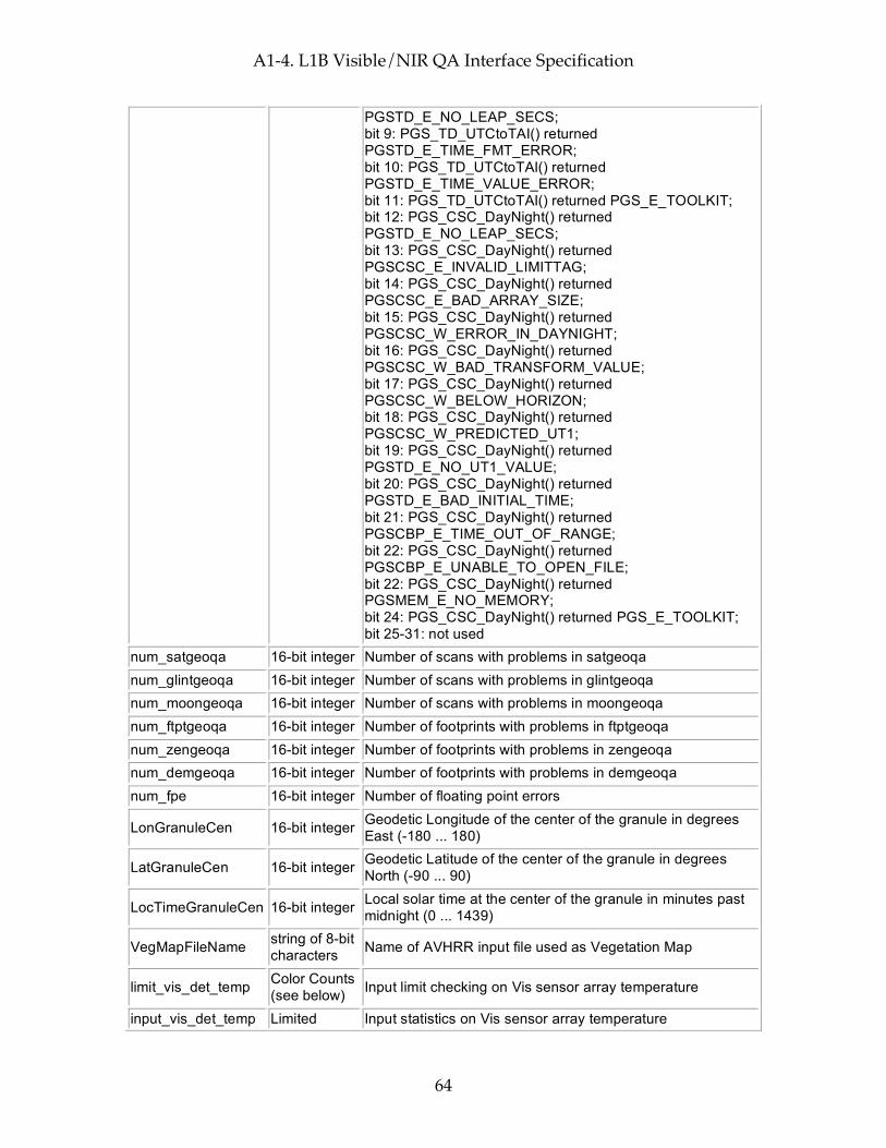
A1-4. L1B Visible/NIR QA Interface Specification
64
PGSTD_E_NO_LEAP_SECS; bit 9: PGS_TD_UTCtoTAI() returned PGSTD_E_TIME_FMT_ERROR; bit 10: PGS_TD_UTCtoTAI() returned PGSTD_E_TIME_VALUE_ERROR; bit 11: PGS_TD_UTCtoTAI() returned PGS_E_TOOLKIT; bit 12: PGS_CSC_DayNight() returned PGSTD_E_NO_LEAP_SECS; bit 13: PGS_CSC_DayNight() returned PGSCSC_E_INVALID_LIMITTAG; bit 14: PGS_CSC_DayNight() returned PGSCSC_E_BAD_ARRAY_SIZE; bit 15: PGS_CSC_DayNight() returned PGSCSC_W_ERROR_IN_DAYNIGHT; bit 16: PGS_CSC_DayNight() returned PGSCSC_W_BAD_TRANSFORM_VALUE; bit 17: PGS_CSC_DayNight() returned PGSCSC_W_BELOW_HORIZON; bit 18: PGS_CSC_DayNight() returned PGSCSC_W_PREDICTED_UT1; bit 19: PGS_CSC_DayNight() returned PGSTD_E_NO_UT1_VALUE; bit 20: PGS_CSC_DayNight() returned PGSTD_E_BAD_INITIAL_TIME; bit 21: PGS_CSC_DayNight() returned PGSCBP_E_TIME_OUT_OF_RANGE; bit 22: PGS_CSC_DayNight() returned PGSCBP_E_UNABLE_TO_OPEN_FILE; bit 22: PGS_CSC_DayNight() returned PGSMEM_E_NO_MEMORY; bit 24: PGS_CSC_DayNight() returned PGS_E_TOOLKIT; bit 25-31: not used
num_satgeoqa 16-bit integer Number of scans with problems in satgeoqa num_glintgeoqa 16-bit integer Number of scans with problems in glintgeoqa num_moongeoqa 16-bit integer Number of scans with problems in moongeoqa num_ftptgeoqa 16-bit integer Number of footprints with problems in ftptgeoqa num_zengeoqa 16-bit integer Number of footprints with problems in zengeoqa num_demgeoqa 16-bit integer Number of footprints with problems in demgeoqa num_fpe 16-bit integer Number of floating point errors
LonGranuleCen 16-bit integer Geodetic Longitude of the center of the granule in degrees East (-180 ... 180)
LatGranuleCen 16-bit integer Geodetic Latitude of the center of the granule in degrees North (-90 ... 90)
LocTimeGranuleCen 16-bit integer Local solar time at the center of the granule in minutes past midnight (0 ... 1439)
VegMapFileName string of 8-bit characters Name of AVHRR input file used as Vegetation Map
limit_vis_det_temp Color Counts (see below) Input limit checking on Vis sensor array temperature
input_vis_det_temp Limited Input statistics on Vis sensor array temperature

A1-4. L1B Visible/NIR QA Interface Specification
65
Engineering Struct (see below)
granules_present string of 8-bit characters
Zero-terminated character string denoting which adjacent granules were available for smoothing ("All" for both previous & next, "Prev" for previous but not next, "Next" for next but not previous, "None" for neither previous nor next)
align_1_2_nadir 32-bit floating-point
Expected error (km) between the pixel locations for the corner locations of near-nadir AIRS footprints (45 & 46) between VIS channels 1 & 2
align_2_3_nadir 32-bit floating-point
Expected error (km) between the pixel locations for the corner locations of near-nadir AIRS footprints (45 & 46) between VIS channels 2 & 3
align_2_4_nadir 32-bit floating-point
Expected error (km) between the pixel locations for the corner locations of near-nadir AIRS footprints (45 & 46) between VIS channels 2 & 4
align_1_2_maxang 32-bit floating-point
Expected error (km) between the pixel locations for the corner locations of near-limb AIRS footprints (1 & 90) between VIS channels 1 & 2
align_2_3_maxang 32-bit floating-point
Expected error (km) between the pixel locations for the corner locations of near-limb AIRS footprints (1 & 90) between VIS channels 2 & 3
align_2_4_maxang 32-bit floating-point
Expected error (km) between the pixel locations for the corner locations of near-limb AIRS footprints (1 & 90) between VIS channels 2 & 4
align_vis_airs 32-bit floating-point
Expected error (km) between the pixel locations for the corner locations of near-nadir AIRS footprints (45 & 46) between the AIRS center and all VIS channels
Size: 343 bytes (0.0 MB) per granule
Per-Granule Data Fields These fields appear only once per granule and use the HDF-EOS "Field" interface
Name Type Extra Dimensions Explanation
limit_scene_counts Color Counts (see below)
Channel (= 4) * SubTrack (= 9)
Input limit checking on scene data numbers
limit_bb_counts Color Counts (see below)
Channel (= 4) * SubTrack (= 9)
Input limit checking on data numbers from the blackbody (dark target)
limit_phot_counts Color Counts (see below)
Channel (= 4) * SubTrack (= 9)
Input limit checking on data numbers from the photometric calibration source (bright target)
input_scene_counts Limited Engineering Struct (see below)
Channel (= 4) * SubTrack (= 9)
Input statistics on scene data numbers
input_bb_counts Limited Engineering Struct (see below)
Channel (= 4) * SubTrack (= 9)
Input statistics on data numbers from the blackbody (dark target)
input_phot_counts Limited Engineering Struct (see below)
Channel (= 4) * SubTrack (= 9)
Input statistics on data numbers from the photometric calibration source (bright target)

A1-4. L1B Visible/NIR QA Interface Specification
66
limit_offsets Color Counts (see below)
Channel (= 4) * SubTrack (= 9) Output limit checking on offsets
offset_stats Unlimited Engineering Struct (see below)
Channel (= 4) * SubTrack (= 9) Statistics on offsets
offset_unc_stats Unlimited Engineering Struct (see below)
Channel (= 4) * SubTrack (= 9) Statistics on offset uncertainties
gain 32-bit floating-point Channel (= 4) * SubTrack (= 9)
Gain: number of radiance units per count.
gain_err 32-bit floating-point Channel (= 4) * SubTrack (= 9)
Error caused by imperfect fit for gain (gain units).
rad_stats Unlimited Engineering Struct (see below)
Channel (= 4) * SubTrack (= 9)
Statistics over the granule of radiances (radiance units)
NeN_stats Limited Engineering Struct (see below)
Channel (= 4) * SubTrack (= 9)
Statistics over the granule of Noise-equivalent Radiance (NeN)
xtrack_err 32-bit floating-point Channel (= 4) cross-track pixel location error estimate per channel (km)
track_err 32-bit floating-point Channel (= 4) Along-track pixel location error estimate per channel (km)
Size: 26528 bytes (0.0 MB) per granule
Along-Track Data Fields These fields appear once per scanline (GeoTrack times)
Name Type Extra Dimensions Explanation
satheight 32-bit floating-point
None Satellite altitude at nadirTAI in km above reference ellipsoid (e.g. 725.2)
satroll 32-bit floating-point
None
Satellite attitude roll angle at nadirTAI (-180.0 ... 180.0 angle about the +x (roll) ORB axis, +x axis is positively oriented in the direction of orbital flight completing an orthogonal triad with y and z.)
satpitch 32-bit floating-point
None
Satellite attitude pitch angle at nadirTAI (-180.0 ... 180.0 angle about +y (pitch) ORB axis. +y axis is oriented normal to the orbit plane with the positive sense opposite to that of the orbit's angular momentum vector H.)
satyaw 32-bit floating-point
None
Satellite attitude yaw angle at nadirTAI (-180.0 ... 180.0 angle about +z (yaw) axis. +z axis is positively oriented Earthward parallel to the satellite radius vector R from the spacecraft center of mass to the center of the Earth.)
satgeoqa 32-bit unsigned integer
None
Satellite Geolocation QA flags: bit 0 (LSB): bad input value; bit 1: PGS_TD_TAItoUTC() returned PGSTD_E_NO_LEAP_SECS; bit 2: PGS_TD_TAItoUTC() returned PGS_E_TOOLKIT;

A1-4. L1B Visible/NIR QA Interface Specification
67
bit 3: PGS_EPH_EphemAttit() returned PGSEPH_W_BAD_EPHEM_VALUE; bit 4: PGS_EPH_EphemAttit() returned PGSEPH_E_BAD_EPHEM_FILE_HDR; bit 5: PGS_EPH_EphemAttit() returned PGSEPH_E_NO_SC_EPHEM_FILE; bit 6: PGS_EPH_EphemAttit() returned PGSEPH_E_NO_DATA_REQUESTED; bit 7: PGS_EPH_EphemAttit() returned PGSTD_E_SC_TAG_UNKNOWN; bit 8: PGS_EPH_EphemAttit() returned PGSEPH_E_BAD_ARRAY_SIZE; bit 9: PGS_EPH_EphemAttit() returned PGSTD_E_TIME_FMT_ERROR; bit 10: PGS_EPH_EphemAttit() returned PGSTD_E_TIME_VALUE_ERROR; bit 11: PGS_EPH_EphemAttit() returned PGSTD_E_NO_LEAP_SECS; bit 12: PGS_EPH_EphemAttit() returned PGS_E_TOOLKIT; bit 13: PGS_CSC_ECItoECR() returned PGSCSC_W_BAD_TRANSFORM_VALUE; bit 14: PGS_CSC_ECItoECR() returned PGSCSC_E_BAD_ARRAY_SIZE; bit 15: PGS_CSC_ECItoECR() returned PGSTD_E_NO_LEAP_SECS; bit 16: PGS_CSC_ECItoECR() returned PGSTD_E_TIME_FMT_ERROR; bit 17: PGS_CSC_ECItoECR() returned PGSTD_E_TIME_VALUE_ERROR; bit 18: unused (set to zero); bit 19: PGS_CSC_ECItoECR() returned PGSTD_E_NO_UT1_VALUE; bit 20: PGS_CSC_ECItoECR() returned PGS_E_TOOLKIT; bit 21: PGS_CSC_ECRtoGEO() returned PGSCSC_W_TOO_MANY_ITERS; bit 22: PGS_CSC_ECRtoGEO() returned PGSCSC_W_INVALID_ALTITUDE; bit 23: PGS_CSC_ECRtoGEO() returned PGSCSC_W_SPHERE_BODY; bit 24: PGS_CSC_ECRtoGEO() returned PGSCSC_W_LARGE_FLATTENING; bit 25: PGS_CSC_ECRtoGEO() returned PGSCSC_W_DEFAULT_EARTH_MODEL; bit 26: PGS_CSC_ECRtoGEO() returned PGSCSC_E_BAD_EARTH_MODEL; bit 27: PGS_CSC_ECRtoGEO() returned PGS_E_TOOLKIT; bit 28-31: not used
glintgeoqa 16-bit unsigned integer
None
Glint Geolocation QA flags: bit 0 (LSB): bad input value; bit 1: glint location in Earth's shadow; bit 2: glint calculation not converging; bit 3: glint location sun vs. satellite zenith mismatch;
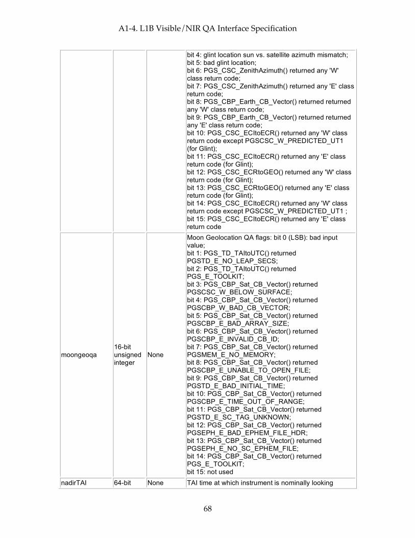
A1-4. L1B Visible/NIR QA Interface Specification
68
bit 4: glint location sun vs. satellite azimuth mismatch; bit 5: bad glint location; bit 6: PGS_CSC_ZenithAzimuth() returned any 'W' class return code; bit 7: PGS_CSC_ZenithAzimuth() returned any 'E' class return code; bit 8: PGS_CBP_Earth_CB_Vector() returned returned any 'W' class return code; bit 9: PGS_CBP_Earth_CB_Vector() returned returned any 'E' class return code; bit 10: PGS_CSC_ECItoECR() returned any 'W' class return code except PGSCSC_W_PREDICTED_UT1 (for Glint); bit 11: PGS_CSC_ECItoECR() returned any 'E' class return code (for Glint); bit 12: PGS_CSC_ECRtoGEO() returned any 'W' class return code (for Glint); bit 13: PGS_CSC_ECRtoGEO() returned any 'E' class return code (for Glint); bit 14: PGS_CSC_ECItoECR() returned any 'W' class return code except PGSCSC_W_PREDICTED_UT1 ; bit 15: PGS_CSC_ECItoECR() returned any 'E' class return code
moongeoqa 16-bit unsigned integer
None
Moon Geolocation QA flags: bit 0 (LSB): bad input value; bit 1: PGS_TD_TAItoUTC() returned PGSTD_E_NO_LEAP_SECS; bit 2: PGS_TD_TAItoUTC() returned PGS_E_TOOLKIT; bit 3: PGS_CBP_Sat_CB_Vector() returned PGSCSC_W_BELOW_SURFACE; bit 4: PGS_CBP_Sat_CB_Vector() returned PGSCBP_W_BAD_CB_VECTOR; bit 5: PGS_CBP_Sat_CB_Vector() returned PGSCBP_E_BAD_ARRAY_SIZE; bit 6: PGS_CBP_Sat_CB_Vector() returned PGSCBP_E_INVALID_CB_ID; bit 7: PGS_CBP_Sat_CB_Vector() returned PGSMEM_E_NO_MEMORY; bit 8: PGS_CBP_Sat_CB_Vector() returned PGSCBP_E_UNABLE_TO_OPEN_FILE; bit 9: PGS_CBP_Sat_CB_Vector() returned PGSTD_E_BAD_INITIAL_TIME; bit 10: PGS_CBP_Sat_CB_Vector() returned PGSCBP_E_TIME_OUT_OF_RANGE; bit 11: PGS_CBP_Sat_CB_Vector() returned PGSTD_E_SC_TAG_UNKNOWN; bit 12: PGS_CBP_Sat_CB_Vector() returned PGSEPH_E_BAD_EPHEM_FILE_HDR; bit 13: PGS_CBP_Sat_CB_Vector() returned PGSEPH_E_NO_SC_EPHEM_FILE; bit 14: PGS_CBP_Sat_CB_Vector() returned PGS_E_TOOLKIT; bit 15: not used
nadirTAI 64-bit None TAI time at which instrument is nominally looking
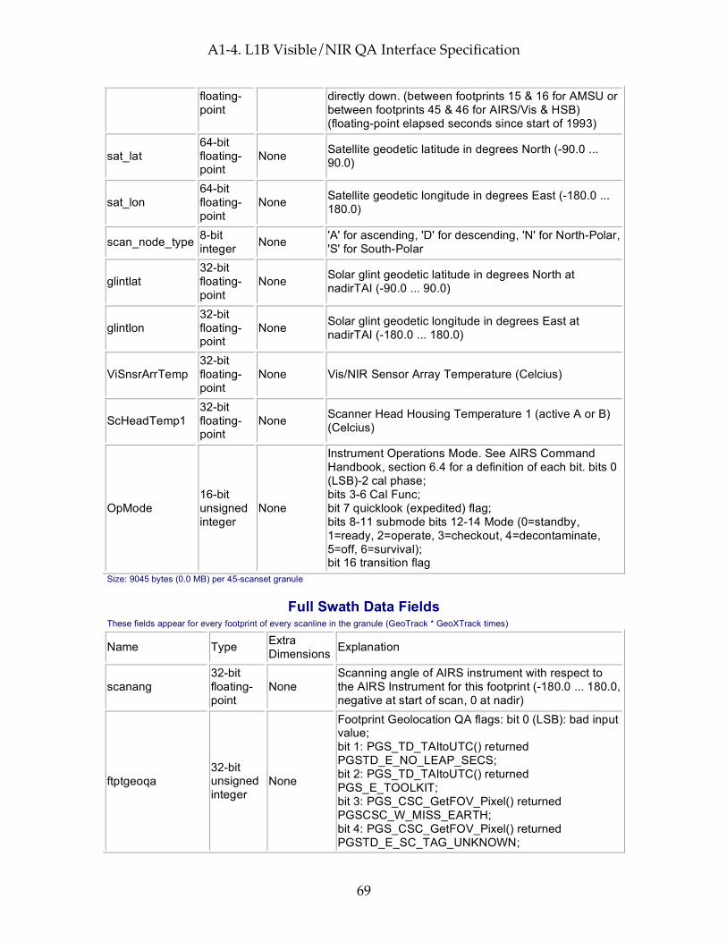
A1-4. L1B Visible/NIR QA Interface Specification
69
floating-point
directly down. (between footprints 15 & 16 for AMSU or between footprints 45 & 46 for AIRS/Vis & HSB) (floating-point elapsed seconds since start of 1993)
sat_lat 64-bit floating-point
None Satellite geodetic latitude in degrees North (-90.0 ... 90.0)
sat_lon 64-bit floating-point
None Satellite geodetic longitude in degrees East (-180.0 ... 180.0)
scan_node_type 8-bit integer None 'A' for ascending, 'D' for descending, 'N' for North-Polar,
'S' for South-Polar
glintlat 32-bit floating-point
None Solar glint geodetic latitude in degrees North at nadirTAI (-90.0 ... 90.0)
glintlon 32-bit floating-point
None Solar glint geodetic longitude in degrees East at nadirTAI (-180.0 ... 180.0)
ViSnsrArrTemp 32-bit floating-point
None Vis/NIR Sensor Array Temperature (Celcius)
ScHeadTemp1 32-bit floating-point
None Scanner Head Housing Temperature 1 (active A or B) (Celcius)
OpMode 16-bit unsigned integer
None
Instrument Operations Mode. See AIRS Command Handbook, section 6.4 for a definition of each bit. bits 0 (LSB)-2 cal phase; bits 3-6 Cal Func; bit 7 quicklook (expedited) flag; bits 8-11 submode bits 12-14 Mode (0=standby, 1=ready, 2=operate, 3=checkout, 4=decontaminate, 5=off, 6=survival); bit 16 transition flag
Size: 9045 bytes (0.0 MB) per 45-scanset granule
Full Swath Data Fields These fields appear for every footprint of every scanline in the granule (GeoTrack * GeoXTrack times)
Name Type Extra Dimensions Explanation
scanang 32-bit floating-point
None Scanning angle of AIRS instrument with respect to the AIRS Instrument for this footprint (-180.0 ... 180.0, negative at start of scan, 0 at nadir)
ftptgeoqa 32-bit unsigned integer
None
Footprint Geolocation QA flags: bit 0 (LSB): bad input value; bit 1: PGS_TD_TAItoUTC() returned PGSTD_E_NO_LEAP_SECS; bit 2: PGS_TD_TAItoUTC() returned PGS_E_TOOLKIT; bit 3: PGS_CSC_GetFOV_Pixel() returned PGSCSC_W_MISS_EARTH; bit 4: PGS_CSC_GetFOV_Pixel() returned PGSTD_E_SC_TAG_UNKNOWN;

A1-4. L1B Visible/NIR QA Interface Specification
70
bit 5: PGS_CSC_GetFOV_Pixel() returned PGSCSC_W_ZERO_PIXEL_VECTOR; bit 6: PGS_CSC_GetFOV_Pixel() returned PGSCSC_W_BAD_EPH_FOR_PIXEL; bit 7: PGS_CSC_GetFOV_Pixel() returned PGSCSC_W_INSTRUMENT_OFF_BOARD; bit 8: PGS_CSC_GetFOV_Pixel() returned PGSCSC_W_BAD_ACCURACY_FLAG; bit 9: PGS_CSC_GetFOV_Pixel() returned PGSCSC_E_BAD_ARRAY_SIZE; bit 10: PGS_CSC_GetFOV_Pixel() returned PGSCSC_W_DEFAULT_EARTH_MODEL; bit 11: PGS_CSC_GetFOV_Pixel() returned PGSCSC_W_DATA_FILE_MISSING; bit 12: PGS_CSC_GetFOV_Pixel() returned PGSCSC_E_NEG_OR_ZERO_RAD; bit 13: PGS_CSC_GetFOV_Pixel() returned PGSMEM_E_NO_MEMORY; bit 14: PGS_CSC_GetFOV_Pixel() returned PGSTD_E_NO_LEAP_SECS; bit 15: PGS_CSC_GetFOV_Pixel() returned PGSTD_E_TIME_FMT_ERROR; bit 16: PGS_CSC_GetFOV_Pixel() returned PGSTD_E_TIME_VALUE_ERROR; bit 17: PGS_CSC_GetFOV_Pixel() returned PGSCSC_W_PREDICTED_UT1; bit 18: PGS_CSC_GetFOV_Pixel() returned PGSTD_E_NO_UT1_VALUE; bit 19: PGS_CSC_GetFOV_Pixel() returned PGS_E_TOOLKIT; bit 20: PGS_CSC_GetFOV_Pixel() returned PGSEPH_E_BAD_EPHEM_FILE_HDR; bit 21: PGS_CSC_GetFOV_Pixel() returned PGSEPH_E_NO_SC_EPHEM_FILE; bit 22-31: not used
zengeoqa 16-bit unsigned integer
None
Satellite zenith Geolocation QA flags: bit 0 (LSB): (Spacecraft) bad input value; bit 1: PGS_CSC_ZenithAzimuth(S/C) returned PGSCSC_W_BELOW_HORIZON; bit 2: PGS_CSC_ZenithAzimuth(S/C) returned PGSCSC_W_UNDEFINED_AZIMUTH; bit 3: PGS_CSC_ZenithAzimuth(S/C) returned PGSCSC_W_NO_REFRACTION; bit 4: PGS_CSC_ZenithAzimuth(S/C) returned PGSCSC_E_INVALID_VECTAG; bit 5: PGS_CSC_ZenithAzimuth(S/C) returned PGSCSC_E_LOOK_PT_ALTIT_RANGE; bit 6: PGS_CSC_ZenithAzimuth(S/C) returned PGSCSC_E_ZERO_INPUT_VECTOR; bit 7: PGS_CSC_ZenithAzimuth(S/C) returned PGS_E_TOOLKIT; bit 8: (Sun) bad input value; bit 9: (suppressed) PGS_CSC_ZenithAzimuth(Sun) returned PGSCSC_W_BELOW_HORIZON (This is not an error condition - the sun is below the horizon
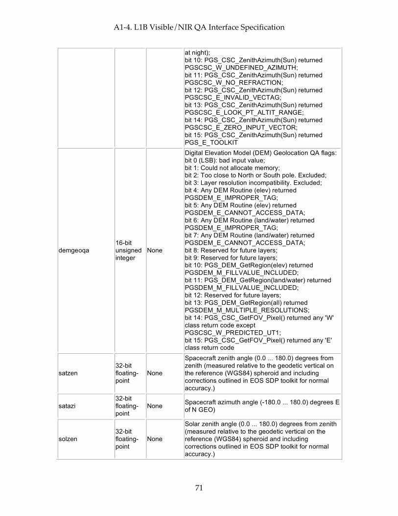
A1-4. L1B Visible/NIR QA Interface Specification
71
at night); bit 10: PGS_CSC_ZenithAzimuth(Sun) returned PGSCSC_W_UNDEFINED_AZIMUTH; bit 11: PGS_CSC_ZenithAzimuth(Sun) returned PGSCSC_W_NO_REFRACTION; bit 12: PGS_CSC_ZenithAzimuth(Sun) returned PGSCSC_E_INVALID_VECTAG; bit 13: PGS_CSC_ZenithAzimuth(Sun) returned PGSCSC_E_LOOK_PT_ALTIT_RANGE; bit 14: PGS_CSC_ZenithAzimuth(Sun) returned PGSCSC_E_ZERO_INPUT_VECTOR; bit 15: PGS_CSC_ZenithAzimuth(Sun) returned PGS_E_TOOLKIT
demgeoqa 16-bit unsigned integer
None
Digital Elevation Model (DEM) Geolocation QA flags: bit 0 (LSB): bad input value; bit 1: Could not allocate memory; bit 2: Too close to North or South pole. Excluded; bit 3: Layer resolution incompatibility. Excluded; bit 4: Any DEM Routine (elev) returned PGSDEM_E_IMPROPER_TAG; bit 5: Any DEM Routine (elev) returned PGSDEM_E_CANNOT_ACCESS_DATA; bit 6: Any DEM Routine (land/water) returned PGSDEM_E_IMPROPER_TAG; bit 7: Any DEM Routine (land/water) returned PGSDEM_E_CANNOT_ACCESS_DATA; bit 8: Reserved for future layers; bit 9: Reserved for future layers; bit 10: PGS_DEM_GetRegion(elev) returned PGSDEM_M_FILLVALUE_INCLUDED; bit 11: PGS_DEM_GetRegion(land/water) returned PGSDEM_M_FILLVALUE_INCLUDED; bit 12: Reserved for future layers; bit 13: PGS_DEM_GetRegion(all) returned PGSDEM_M_MULTIPLE_RESOLUTIONS; bit 14: PGS_CSC_GetFOV_Pixel() returned any 'W' class return code except PGSCSC_W_PREDICTED_UT1; bit 15: PGS_CSC_GetFOV_Pixel() returned any 'E' class return code
satzen 32-bit floating-point
None
Spacecraft zenith angle (0.0 ... 180.0) degrees from zenith (measured relative to the geodetic vertical on the reference (WGS84) spheroid and including corrections outlined in EOS SDP toolkit for normal accuracy.)
satazi 32-bit floating-point
None Spacecraft azimuth angle (-180.0 ... 180.0) degrees E of N GEO)
solzen 32-bit floating-point
None
Solar zenith angle (0.0 ... 180.0) degrees from zenith (measured relative to the geodetic vertical on the reference (WGS84) spheroid and including corrections outlined in EOS SDP toolkit for normal accuracy.)
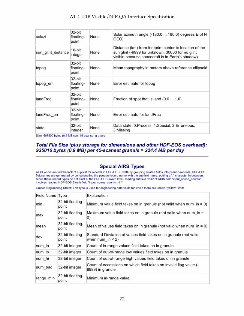
A1-4. L1B Visible/NIR QA Interface Specification
72
solazi 32-bit floating-point
None Solar azimuth angle (-180.0 ... 180.0) degrees E of N GEO)
sun_glint_distance 16-bit integer None
Distance (km) from footprint center to location of the sun glint (-9999 for unknown, 30000 for no glint visible because spacecraft is in Earth's shadow)
topog 32-bit floating-point
None Mean topography in meters above reference ellipsoid
topog_err 32-bit floating-point
None Error estimate for topog
landFrac 32-bit floating-point
None Fraction of spot that is land (0.0 ... 1.0)
landFrac_err 32-bit floating-point
None Error estimate for landFrac
state 32-bit integer None Data state: 0:Process, 1:Special, 2:Erroneous,
3:Missing Size: 607500 bytes (0.6 MB) per 45-scanset granule
Total File Size (plus storage for dimensions and other HDF-EOS overhead): 935016 bytes (0.9 MB) per 45-scanset granule = 224.4 MB per day
Special AIRS Types AIRS works around the lack of support for records in HDF-EOS Swath by grouping related fields into pseudo-records. HDF-EOS fieldnames are generated by concatenating the pseudo-record name with the subfield name, putting a "." character in between. Since these record types do not exist at the HDF-EOS swath level, reading subfield "min" of AIRS field "input_scene_counts" involves reading HDF-EOS Swath field "input_scene_counts.min".
Limited Engineering Struct: This type is used for engineering data fields for which there are known "yellow" limits
Field Name Type Explanation
min 32-bit floating-point Minimum value field takes on in granule (not valid when num_in = 0)
max 32-bit floating-point
Maximum value field takes on in granule (not valid when num_in = 0)
mean 32-bit floating-point Mean of values field takes on in granule (not valid when num_in = 0)
dev 32-bit floating-point
Standard Deviation of values field takes on in granule (not valid when num_in < 2)
num_in 32-bit integer Count of in-range values field takes on in granule num_lo 32-bit integer Count of out-of-range low values field takes on in granule num_hi 32-bit integer Count of out-of-range high values field takes on in granule
num_bad 32-bit integer Count of occassions on which field takes on invalid flag value (-9999) in granule
range_min 32-bit floating-point Minimum in-range value.
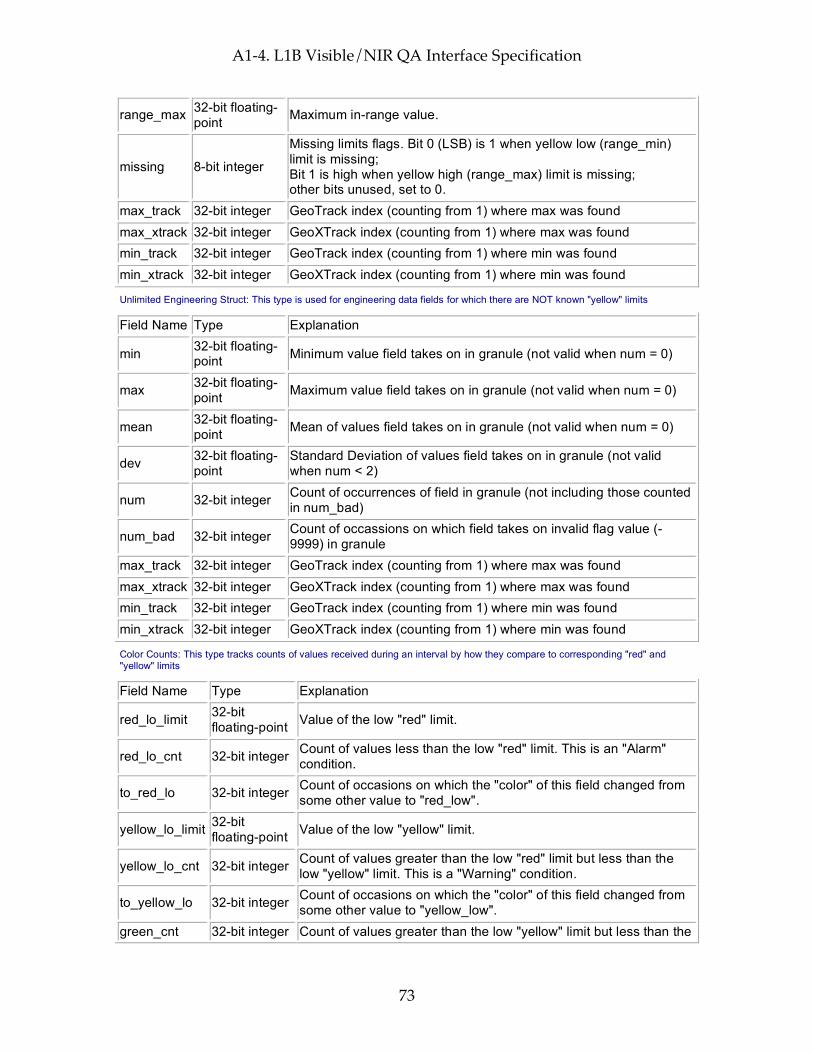
A1-4. L1B Visible/NIR QA Interface Specification
73
range_max 32-bit floating-point Maximum in-range value.
missing 8-bit integer
Missing limits flags. Bit 0 (LSB) is 1 when yellow low (range_min) limit is missing; Bit 1 is high when yellow high (range_max) limit is missing; other bits unused, set to 0.
max_track 32-bit integer GeoTrack index (counting from 1) where max was found max_xtrack 32-bit integer GeoXTrack index (counting from 1) where max was found min_track 32-bit integer GeoTrack index (counting from 1) where min was found min_xtrack 32-bit integer GeoXTrack index (counting from 1) where min was found
Unlimited Engineering Struct: This type is used for engineering data fields for which there are NOT known "yellow" limits
Field Name Type Explanation
min 32-bit floating-point Minimum value field takes on in granule (not valid when num = 0)
max 32-bit floating-point Maximum value field takes on in granule (not valid when num = 0)
mean 32-bit floating-point Mean of values field takes on in granule (not valid when num = 0)
dev 32-bit floating-point
Standard Deviation of values field takes on in granule (not valid when num < 2)
num 32-bit integer Count of occurrences of field in granule (not including those counted in num_bad)
num_bad 32-bit integer Count of occassions on which field takes on invalid flag value (-9999) in granule
max_track 32-bit integer GeoTrack index (counting from 1) where max was found max_xtrack 32-bit integer GeoXTrack index (counting from 1) where max was found min_track 32-bit integer GeoTrack index (counting from 1) where min was found min_xtrack 32-bit integer GeoXTrack index (counting from 1) where min was found
Color Counts: This type tracks counts of values received during an interval by how they compare to corresponding "red" and "yellow" limits
Field Name Type Explanation
red_lo_limit 32-bit floating-point Value of the low "red" limit.
red_lo_cnt 32-bit integer Count of values less than the low "red" limit. This is an "Alarm" condition.
to_red_lo 32-bit integer Count of occasions on which the "color" of this field changed from some other value to "red_low".
yellow_lo_limit 32-bit floating-point Value of the low "yellow" limit.
yellow_lo_cnt 32-bit integer Count of values greater than the low "red" limit but less than the low "yellow" limit. This is a "Warning" condition.
to_yellow_lo 32-bit integer Count of occasions on which the "color" of this field changed from some other value to "yellow_low".
green_cnt 32-bit integer Count of values greater than the low "yellow" limit but less than the
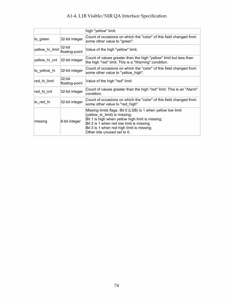
A1-4. L1B Visible/NIR QA Interface Specification
74
high "yellow" limit.
to_green 32-bit integer Count of occasions on which the "color" of this field changed from some other value to "green".
yellow_hi_limit 32-bit floating-point Value of the high "yellow" limit.
yellow_hi_cnt 32-bit integer Count of values greater than the high "yellow" limit but less than the high "red" limit. This is a "Warning" condition.
to_yellow_hi 32-bit integer Count of occasions on which the "color" of this field changed from some other value to "yellow_high".
red_hi_limit 32-bit floating-point Value of the high "red" limit.
red_hi_cnt 32-bit integer Count of values greater than the high "red" limit. This is an "Alarm" condition.
to_red_hi 32-bit integer Count of occasions on which the "color" of this field changed from some other value to "red_high".
missing 8-bit integer
Missing limits flags. Bit 0 (LSB) is 1 when yellow low limit (yellow_lo_limit) is missing; Bit 1 is high when yellow high limit is missing; Bit 2 is 1 when red low limit is missing; Bit 3 is 1 when red high limit is missing; Other bits unused set to 0.

A1-5. L1B AMSU-A Interface Specification
75
A1-5. L1B AMSU-A Interface Specification
Interface Specification Version 4.0.9.0 2005-02-01
ESDT ShortName = "AIRABRAD"
Swath Name = "L1B_AMSU"
Level = "level1B"
# Footprints = 30
# scanlines per scanset = 1
Dimensions These fields define all dimensions that can be used for HDF-EOS swath fields.
The names "GeoTrack" and "GeoXTrack" have a special meaning for this document: "Cross-Track" data fields have a hidden dimension of "GeoXTrack"; "Along-Track" data fields have a hidden dimension of "GeoTrack"; "Full Swath Data Fields have hidden dimensions of both "GeoTrack" and "GeoXTrack".
Name Value Explanation
GeoXTrack 30 Dimension across track for footprint positions. Same as number of footprints per scanline. -- starting at the left and increasing towards the right as you look along the satellite's path
GeoTrack # of scan lines in swath
Dimension along track for footprint positions. Same as number of scanlines in granule. Parallel to the satellite's path, increasing with time. (Nominally 45 for Level-2, AMSU-A, and AIRS/Vis low-rate engineering; 135 for AIRS/Vis and HSB high-rate quantities)
Channel 15
Dimension of channel array (Channel 1: 23.8 GHz; Ch 2: 31.4 GHz; Ch 3: 50.3 GHz; Ch 4: 52.8 GHz; Ch 5: 53.596 0.115 GHz; Ch 6: 54.4 GHz; Ch 7: 54.94 GHz; Ch 8: 55.5 GHz; Ch 9: f0; Ch 10: f0 0.217 GHz Ch 11: f0 df 48 MHz; Ch 12: f0 df 22 MHz; Ch 13: f0 df 10 MHz; Ch 14: f0 df 4.5 MHz; Ch 15: 89 GHz (f0 = 57290.344 MHz; df = 322.4 MHz))
CalXTrack 4
Dimension "across" track for calibration footprint positions. Same as number of calibration footprints per scanline. (NUM_FOOTPRINTS_AMSU_CALIB) (Footprints are ordered: 1-2: spaceviews; 3-4: blackbody radiometric calibration source)
SpaceXTrack 2 Dimension "across" track for spaceview calibration footprint positions in
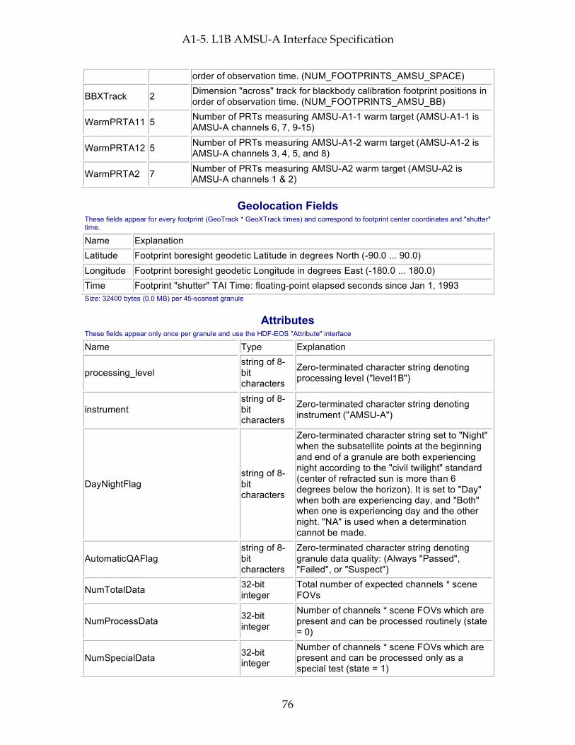
A1-5. L1B AMSU-A Interface Specification
76
order of observation time. (NUM_FOOTPRINTS_AMSU_SPACE)
BBXTrack 2 Dimension "across" track for blackbody calibration footprint positions in order of observation time. (NUM_FOOTPRINTS_AMSU_BB)
WarmPRTA11 5 Number of PRTs measuring AMSU-A1-1 warm target (AMSU-A1-1 is AMSU-A channels 6, 7, 9-15)
WarmPRTA12 5 Number of PRTs measuring AMSU-A1-2 warm target (AMSU-A1-2 is AMSU-A channels 3, 4, 5, and 8)
WarmPRTA2 7 Number of PRTs measuring AMSU-A2 warm target (AMSU-A2 is AMSU-A channels 1 & 2)
Geolocation Fields These fields appear for every footprint (GeoTrack * GeoXTrack times) and correspond to footprint center coordinates and "shutter" time.
Name Explanation Latitude Footprint boresight geodetic Latitude in degrees North (-90.0 ... 90.0) Longitude Footprint boresight geodetic Longitude in degrees East (-180.0 ... 180.0) Time Footprint "shutter" TAI Time: floating-point elapsed seconds since Jan 1, 1993 Size: 32400 bytes (0.0 MB) per 45-scanset granule
Attributes These fields appear only once per granule and use the HDF-EOS "Attribute" interface
Name Type Explanation
processing_level string of 8-bit characters
Zero-terminated character string denoting processing level ("level1B")
instrument string of 8-bit characters
Zero-terminated character string denoting instrument ("AMSU-A")
DayNightFlag string of 8-bit characters
Zero-terminated character string set to "Night" when the subsatellite points at the beginning and end of a granule are both experiencing night according to the "civil twilight" standard (center of refracted sun is more than 6 degrees below the horizon). It is set to "Day" when both are experiencing day, and "Both" when one is experiencing day and the other night. "NA" is used when a determination cannot be made.
AutomaticQAFlag string of 8-bit characters
Zero-terminated character string denoting granule data quality: (Always "Passed", "Failed", or "Suspect")
NumTotalData 32-bit integer
Total number of expected channels * scene FOVs
NumProcessData 32-bit integer
Number of channels * scene FOVs which are present and can be processed routinely (state = 0)
NumSpecialData 32-bit integer
Number of channels * scene FOVs which are present and can be processed only as a special test (state = 1)
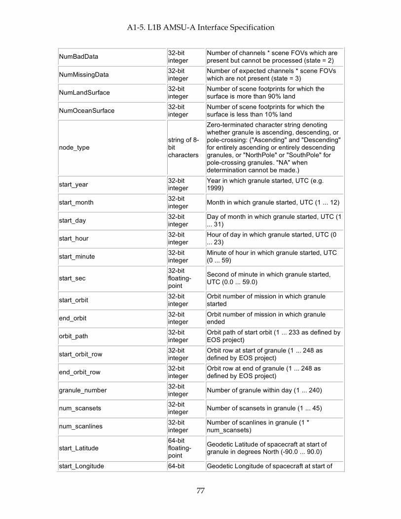
A1-5. L1B AMSU-A Interface Specification
77
NumBadData 32-bit integer
Number of channels * scene FOVs which are present but cannot be processed (state = 2)
NumMissingData 32-bit integer
Number of expected channels * scene FOVs which are not present (state = 3)
NumLandSurface 32-bit integer
Number of scene footprints for which the surface is more than 90% land
NumOceanSurface 32-bit integer
Number of scene footprints for which the surface is less than 10% land
node_type string of 8-bit characters
Zero-terminated character string denoting whether granule is ascending, descending, or pole-crossing: ("Ascending" and "Descending" for entirely ascending or entirely descending granules, or "NorthPole" or "SouthPole" for pole-crossing granules. "NA" when determination cannot be made.)
start_year 32-bit integer
Year in which granule started, UTC (e.g. 1999)
start_month 32-bit integer Month in which granule started, UTC (1 ... 12)
start_day 32-bit integer
Day of month in which granule started, UTC (1 ... 31)
start_hour 32-bit integer
Hour of day in which granule started, UTC (0 ... 23)
start_minute 32-bit integer
Minute of hour in which granule started, UTC (0 ... 59)
start_sec 32-bit floating-point
Second of minute in which granule started, UTC (0.0 ... 59.0)
start_orbit 32-bit integer
Orbit number of mission in which granule started
end_orbit 32-bit integer
Orbit number of mission in which granule ended
orbit_path 32-bit integer
Orbit path of start orbit (1 ... 233 as defined by EOS project)
start_orbit_row 32-bit integer
Orbit row at start of granule (1 ... 248 as defined by EOS project)
end_orbit_row 32-bit integer
Orbit row at end of granule (1 ... 248 as defined by EOS project)
granule_number 32-bit integer Number of granule within day (1 ... 240)
num_scansets 32-bit integer Number of scansets in granule (1 ... 45)
num_scanlines 32-bit integer
Number of scanlines in granule (1 * num_scansets)
start_Latitude 64-bit floating-point
Geodetic Latitude of spacecraft at start of granule in degrees North (-90.0 ... 90.0)
start_Longitude 64-bit Geodetic Longitude of spacecraft at start of

A1-5. L1B AMSU-A Interface Specification
78
floating-point
granule in degrees East (-180.0 ... 180.0)
start_Time 64-bit floating-point
TAI Time at start of granule (floating-point elapsed seconds since start of 1993)
end_Latitude 64-bit floating-point
Geodetic Latitude of spacecraft at end of granule in degrees North (-90.0 ... 90.0)
end_Longitude 64-bit floating-point
Geodetic Longitude of spacecraft at end of granule in degrees East (-180.0 ... 180.0)
end_Time 64-bit floating-point
TAI Time at end of granule (floating-point elapsed seconds since start of 1993)
eq_x_longitude 32-bit floating-point
Longitude of spacecraft at southward equator crossing nearest granule start in degrees East (-180.0 ... 180.0)
eq_x_tai 64-bit floating-point
Time of eq_x_longitude in TAI units (floating-point elapsed seconds since start of 1993)
orbitgeoqa 32-bit unsigned integer
Orbit Geolocation QA: bit 0 (LSB): bad input value (last scanline); bit 1: bad input value (first scanline); bit 2: PGS_EPH_GetEphMet() returned PGSEPH_E_NO_SC_EPHEM_FILE; bit 3: PGS_EPH_GetEphMet() returned PGSEPH_E_BAD_ARRAY_SIZE; bit 4: PGS_EPH_GetEphMet() returned PGSTD_E_TIME_FMT_ERROR; bit 5: PGS_EPH_GetEphMet() returned PGSTD_E_TIME_VALUE_ERROR; bit 6: PGS_EPH_GetEphMet() returned PGSTD_E_SC_TAG_UNKNOWN; bit 7: PGS_EPH_GetEphMet() returned PGS_E_TOOLKIT; bit 8: PGS_TD_UTCtoTAI() returned PGSTD_E_NO_LEAP_SECS; bit 9: PGS_TD_UTCtoTAI() returned PGSTD_E_TIME_FMT_ERROR; bit 10: PGS_TD_UTCtoTAI() returned PGSTD_E_TIME_VALUE_ERROR; bit 11: PGS_TD_UTCtoTAI() returned PGS_E_TOOLKIT; bit 12: PGS_CSC_DayNight() returned PGSTD_E_NO_LEAP_SECS; bit 13: PGS_CSC_DayNight() returned PGSCSC_E_INVALID_LIMITTAG; bit 14: PGS_CSC_DayNight() returned PGSCSC_E_BAD_ARRAY_SIZE; bit 15: PGS_CSC_DayNight() returned PGSCSC_W_ERROR_IN_DAYNIGHT; bit 16: PGS_CSC_DayNight() returned PGSCSC_W_BAD_TRANSFORM_VALUE;
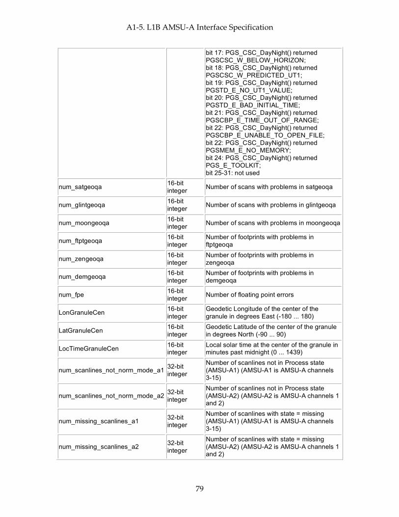
A1-5. L1B AMSU-A Interface Specification
79
bit 17: PGS_CSC_DayNight() returned PGSCSC_W_BELOW_HORIZON; bit 18: PGS_CSC_DayNight() returned PGSCSC_W_PREDICTED_UT1; bit 19: PGS_CSC_DayNight() returned PGSTD_E_NO_UT1_VALUE; bit 20: PGS_CSC_DayNight() returned PGSTD_E_BAD_INITIAL_TIME; bit 21: PGS_CSC_DayNight() returned PGSCBP_E_TIME_OUT_OF_RANGE; bit 22: PGS_CSC_DayNight() returned PGSCBP_E_UNABLE_TO_OPEN_FILE; bit 22: PGS_CSC_DayNight() returned PGSMEM_E_NO_MEMORY; bit 24: PGS_CSC_DayNight() returned PGS_E_TOOLKIT; bit 25-31: not used
num_satgeoqa 16-bit integer Number of scans with problems in satgeoqa
num_glintgeoqa 16-bit integer Number of scans with problems in glintgeoqa
num_moongeoqa 16-bit integer Number of scans with problems in moongeoqa
num_ftptgeoqa 16-bit integer
Number of footprints with problems in ftptgeoqa
num_zengeoqa 16-bit integer
Number of footprints with problems in zengeoqa
num_demgeoqa 16-bit integer
Number of footprints with problems in demgeoqa
num_fpe 16-bit integer Number of floating point errors
LonGranuleCen 16-bit integer
Geodetic Longitude of the center of the granule in degrees East (-180 ... 180)
LatGranuleCen 16-bit integer
Geodetic Latitude of the center of the granule in degrees North (-90 ... 90)
LocTimeGranuleCen 16-bit integer
Local solar time at the center of the granule in minutes past midnight (0 ... 1439)
num_scanlines_not_norm_mode_a1 32-bit integer
Number of scanlines not in Process state (AMSU-A1) (AMSU-A1 is AMSU-A channels 3-15)
num_scanlines_not_norm_mode_a2 32-bit integer
Number of scanlines not in Process state (AMSU-A2) (AMSU-A2 is AMSU-A channels 1 and 2)
num_missing_scanlines_a1 32-bit integer
Number of scanlines with state = missing (AMSU-A1) (AMSU-A1 is AMSU-A channels 3-15)
num_missing_scanlines_a2 32-bit integer
Number of scanlines with state = missing (AMSU-A2) (AMSU-A2 is AMSU-A channels 1 and 2)

A1-5. L1B AMSU-A Interface Specification
80
num_data_gaps_a1 32-bit integer
Number of blocks of scanlines where State is not Process (AMSU-A1) (AMSU-A1 is AMSU-A channels 3-15)
num_data_gaps_a2 32-bit integer
Number of blocks of scanlines where State is not Process (AMSU-A2) (AMSU-A2 is AMSU-A channels 1 and 2)
num_instr_mode_changes_a1 32-bit integer
Number of operational instrument mode changes (AMSU-A1) (AMSU-A1 is AMSU-A channels 3-15)
num_instr_mode_changes_a2 32-bit integer
Number of operational instrument mode changes (AMSU-A2) (AMSU-A2 is AMSU-A channels 1 and 2)
num_scanlines_rec_cal_prob_a11 32-bit integer
Number of scanlines with non-zero qa_receiver (AMSU-A1-1) (AMSU-A1-1 is AMSU-A channels 6, 7, 9-15)
num_scanlines_rec_cal_prob_a12 32-bit integer
Number of scanlines with non-zero qa_receiver (AMSU-A1-2) (AMSU-A1-2 is AMSU-A channels 3, 4, 5, and 8)
num_scanlines_rec_cal_prob_a2 32-bit integer
Number of scanlines with non-zero qa_receiver (AMSU-A2) (AMSU-A2 is AMSU-A channels 1 and 2)
num_scanlines_sig_coast_xing 32-bit integer
Number of scanlines with qa_scanline coast crossing bit set
num_scanlines_sig_sun_glint 32-bit integer
Number of scanlines with qa_scanline sun glint bit set
MoonInViewMWCount 32-bit integer
Number of scanlines in granule with the moon in the AMSU-A1 space view plus number of scanlines in granule with the moon in the AMSU-A2 space view (0-90)
QA_bb_PRT_a11
Limited Engineering Struct (see below)
Blackbody PRT temperature summary QA (AMSU-A1-1) (AMSU-A1-1 is AMSU-A channels 6, 7, 9-15) (C)
QA_bb_PRT_a12
Limited Engineering Struct (see below)
Blackbody PRT temperature summary QA (AMSU-A1-2) (AMSU-A1-2 is AMSU-A channels 3, 4, 5, and 8) (C)
QA_bb_PRT_a2
Limited Engineering Struct (see below)
Blackbody PRT temperature summary QA (AMSU-A2) (AMSU-A2 is AMSU-A channels 1 and 2) (C)
QA_rec_PRT_a11
Limited Engineering Struct (see below)
Receiver PRT temperature summary QA (AMSU-A1-1) (AMSU-A1-1 is AMSU-A channels 6, 7, 9-15) (C)
QA_rec_PRT_a12
Limited Engineering Struct (see below)
Receiver PRT temperature summary QA (AMSU-A1-2) (AMSU-A1-2 is AMSU-A channels 3, 4, 5, and 8) (C)
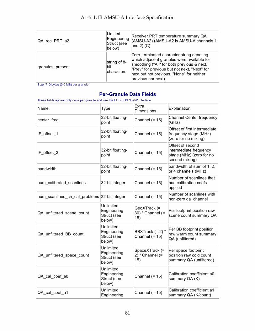
A1-5. L1B AMSU-A Interface Specification
81
QA_rec_PRT_a2
Limited Engineering Struct (see below)
Receiver PRT temperature summary QA (AMSU-A2) (AMSU-A2 is AMSU-A channels 1 and 2) (C)
granules_present string of 8-bit characters
Zero-terminated character string denoting which adjacent granules were available for smoothing ("All" for both previous & next, "Prev" for previous but not next, "Next" for next but not previous, "None" for neither previous nor next)
Size: 710 bytes (0.0 MB) per granule
Per-Granule Data Fields These fields appear only once per granule and use the HDF-EOS "Field" interface
Name Type Extra Dimensions Explanation
center_freq 32-bit floating-point Channel (= 15) Channel Center frequency
(GHz)
IF_offset_1 32-bit floating-point Channel (= 15)
Offset of first intermediate frequency stage (MHz) (zero for no mixing)
IF_offset_2 32-bit floating-point Channel (= 15)
Offset of second intermediate frequency stage (MHz) (zero for no second mixing)
bandwidth 32-bit floating-point Channel (= 15) bandwidth of sum of 1, 2,
or 4 channels (MHz)
num_calibrated_scanlines 32-bit integer Channel (= 15) Number of scanlines that had calibration coefs applied
num_scanlines_ch_cal_problems 32-bit integer Channel (= 15) Number of scanlines with non-zero qa_channel
QA_unfiltered_scene_count
Unlimited Engineering Struct (see below)
GeoXTrack (= 30) * Channel (= 15)
Per footprint position raw scene count summary QA
QA_unfiltered_BB_count
Unlimited Engineering Struct (see below)
BBXTrack (= 2) * Channel (= 15)
Per BB footprint position raw warm count summary QA (unfiltered)
QA_unfiltered_space_count
Unlimited Engineering Struct (see below)
SpaceXTrack (= 2) * Channel (= 15)
Per space footprint position raw cold count summary QA (unfiltered)
QA_cal_coef_a0
Unlimited Engineering Struct (see below)
Channel (= 15) Calibration coefficient a0 summary QA (K)
QA_cal_coef_a1 Unlimited Engineering Channel (= 15) Calibration coefficient a1
summary QA (K/count)

A1-5. L1B AMSU-A Interface Specification
82
Struct (see below)
QA_cal_coef_a2
Unlimited Engineering Struct (see below)
Channel (= 15) Calibration coefficient a2 summary QA (K/count**2)
QA_bb_raw_noise_counts
Unlimited Engineering Struct (see below)
Channel (= 15)
Summary QA on differences between warm cal counts, DT=ABS(T1-T2)/SQRT(2)
QA_sv_raw_noise_counts
Unlimited Engineering Struct (see below)
Channel (= 15)
Summary QA on differences between cold cal counts, DT=ABS(T1-T2)/SQRT(2)
QA_NeDT
Unlimited Engineering Struct (see below)
Channel (= 15) Summary QA on gain * differences between warm cal counts (K)
QA_NeDT2NomRatio
Unlimited Engineering Struct (see below)
Channel (= 15)
Summary QA on gain * differences between warm cal counts over nominal NeDT (unitless)
Size: 34800 bytes (0.0 MB) per granule
Along-Track Data Fields These fields appear once per scanline (GeoTrack times)
Name Type Extra Dimensions Explanation
satheight 32-bit floating-point
None Satellite altitude at nadirTAI in km above reference ellipsoid (e.g. 725.2)
satroll 32-bit floating-point
None
Satellite attitude roll angle at nadirTAI (-180.0 ... 180.0 angle about the (roll) ORB axis, axis is positively oriented in the direction of orbital flight completing an orthogonal triad with y and z.)
satpitch 32-bit floating-point
None
Satellite attitude pitch angle at nadirTAI (-180.0 ... 180.0 angle about (pitch) ORB axis. axis is oriented normal to the orbit plane with the positive sense opposite to that of the orbit's angular momentum vector H.)
satyaw 32-bit floating-point
None
Satellite attitude yaw angle at nadirTAI (-180.0 ... 180.0 angle about (yaw) axis. axis is positively oriented Earthward parallel to the satellite radius vector R from the spacecraft center of mass to the center of the Earth.)
satgeoqa 32-bit unsigned integer
None
Satellite Geolocation QA flags: bit 0 (LSB): bad input value; bit 1: PGS_TD_TAItoUTC() returned PGSTD_E_NO_LEAP_SECS; bit 2: PGS_TD_TAItoUTC() returned PGS_E_TOOLKIT;
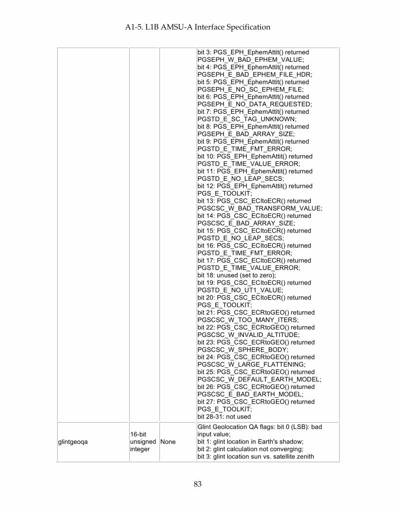
A1-5. L1B AMSU-A Interface Specification
83
bit 3: PGS_EPH_EphemAttit() returned PGSEPH_W_BAD_EPHEM_VALUE; bit 4: PGS_EPH_EphemAttit() returned PGSEPH_E_BAD_EPHEM_FILE_HDR; bit 5: PGS_EPH_EphemAttit() returned PGSEPH_E_NO_SC_EPHEM_FILE; bit 6: PGS_EPH_EphemAttit() returned PGSEPH_E_NO_DATA_REQUESTED; bit 7: PGS_EPH_EphemAttit() returned PGSTD_E_SC_TAG_UNKNOWN; bit 8: PGS_EPH_EphemAttit() returned PGSEPH_E_BAD_ARRAY_SIZE; bit 9: PGS_EPH_EphemAttit() returned PGSTD_E_TIME_FMT_ERROR; bit 10: PGS_EPH_EphemAttit() returned PGSTD_E_TIME_VALUE_ERROR; bit 11: PGS_EPH_EphemAttit() returned PGSTD_E_NO_LEAP_SECS; bit 12: PGS_EPH_EphemAttit() returned PGS_E_TOOLKIT; bit 13: PGS_CSC_ECItoECR() returned PGSCSC_W_BAD_TRANSFORM_VALUE; bit 14: PGS_CSC_ECItoECR() returned PGSCSC_E_BAD_ARRAY_SIZE; bit 15: PGS_CSC_ECItoECR() returned PGSTD_E_NO_LEAP_SECS; bit 16: PGS_CSC_ECItoECR() returned PGSTD_E_TIME_FMT_ERROR; bit 17: PGS_CSC_ECItoECR() returned PGSTD_E_TIME_VALUE_ERROR; bit 18: unused (set to zero); bit 19: PGS_CSC_ECItoECR() returned PGSTD_E_NO_UT1_VALUE; bit 20: PGS_CSC_ECItoECR() returned PGS_E_TOOLKIT; bit 21: PGS_CSC_ECRtoGEO() returned PGSCSC_W_TOO_MANY_ITERS; bit 22: PGS_CSC_ECRtoGEO() returned PGSCSC_W_INVALID_ALTITUDE; bit 23: PGS_CSC_ECRtoGEO() returned PGSCSC_W_SPHERE_BODY; bit 24: PGS_CSC_ECRtoGEO() returned PGSCSC_W_LARGE_FLATTENING; bit 25: PGS_CSC_ECRtoGEO() returned PGSCSC_W_DEFAULT_EARTH_MODEL; bit 26: PGS_CSC_ECRtoGEO() returned PGSCSC_E_BAD_EARTH_MODEL; bit 27: PGS_CSC_ECRtoGEO() returned PGS_E_TOOLKIT; bit 28-31: not used
glintgeoqa 16-bit unsigned integer
None
Glint Geolocation QA flags: bit 0 (LSB): bad input value; bit 1: glint location in Earth's shadow; bit 2: glint calculation not converging; bit 3: glint location sun vs. satellite zenith

A1-5. L1B AMSU-A Interface Specification
84
mismatch; bit 4: glint location sun vs. satellite azimuth mismatch; bit 5: bad glint location; bit 6: PGS_CSC_ZenithAzimuth() returned any 'W' class return code; bit 7: PGS_CSC_ZenithAzimuth() returned any 'E' class return code; bit 8: PGS_CBP_Earth_CB_Vector() returned returned any 'W' class return code; bit 9: PGS_CBP_Earth_CB_Vector() returned returned any 'E' class return code; bit 10: PGS_CSC_ECItoECR() returned any 'W' class return code except PGSCSC_W_PREDICTED_UT1 (for Glint); bit 11: PGS_CSC_ECItoECR() returned any 'E' class return code (for Glint); bit 12: PGS_CSC_ECRtoGEO() returned any 'W' class return code (for Glint); bit 13: PGS_CSC_ECRtoGEO() returned any 'E' class return code (for Glint); bit 14: PGS_CSC_ECItoECR() returned any 'W' class return code except PGSCSC_W_PREDICTED_UT1 ; bit 15: PGS_CSC_ECItoECR() returned any 'E' class return code
moongeoqa 16-bit unsigned integer
None
Moon Geolocation QA flags: bit 0 (LSB): bad input value; bit 1: PGS_TD_TAItoUTC() returned PGSTD_E_NO_LEAP_SECS; bit 2: PGS_TD_TAItoUTC() returned PGS_E_TOOLKIT; bit 3: PGS_CBP_Sat_CB_Vector() returned PGSCSC_W_BELOW_SURFACE; bit 4: PGS_CBP_Sat_CB_Vector() returned PGSCBP_W_BAD_CB_VECTOR; bit 5: PGS_CBP_Sat_CB_Vector() returned PGSCBP_E_BAD_ARRAY_SIZE; bit 6: PGS_CBP_Sat_CB_Vector() returned PGSCBP_E_INVALID_CB_ID; bit 7: PGS_CBP_Sat_CB_Vector() returned PGSMEM_E_NO_MEMORY; bit 8: PGS_CBP_Sat_CB_Vector() returned PGSCBP_E_UNABLE_TO_OPEN_FILE; bit 9: PGS_CBP_Sat_CB_Vector() returned PGSTD_E_BAD_INITIAL_TIME; bit 10: PGS_CBP_Sat_CB_Vector() returned PGSCBP_E_TIME_OUT_OF_RANGE; bit 11: PGS_CBP_Sat_CB_Vector() returned PGSTD_E_SC_TAG_UNKNOWN; bit 12: PGS_CBP_Sat_CB_Vector() returned PGSEPH_E_BAD_EPHEM_FILE_HDR; bit 13: PGS_CBP_Sat_CB_Vector() returned PGSEPH_E_NO_SC_EPHEM_FILE; bit 14: PGS_CBP_Sat_CB_Vector() returned
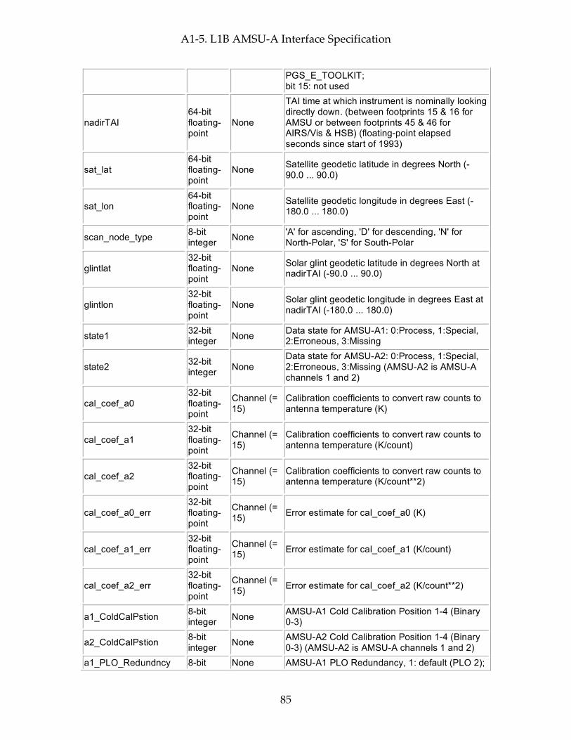
A1-5. L1B AMSU-A Interface Specification
85
PGS_E_TOOLKIT; bit 15: not used
nadirTAI 64-bit floating-point
None
TAI time at which instrument is nominally looking directly down. (between footprints 15 & 16 for AMSU or between footprints 45 & 46 for AIRS/Vis & HSB) (floating-point elapsed seconds since start of 1993)
sat_lat 64-bit floating-point
None Satellite geodetic latitude in degrees North (-90.0 ... 90.0)
sat_lon 64-bit floating-point
None Satellite geodetic longitude in degrees East (-180.0 ... 180.0)
scan_node_type 8-bit integer None 'A' for ascending, 'D' for descending, 'N' for
North-Polar, 'S' for South-Polar
glintlat 32-bit floating-point
None Solar glint geodetic latitude in degrees North at nadirTAI (-90.0 ... 90.0)
glintlon 32-bit floating-point
None Solar glint geodetic longitude in degrees East at nadirTAI (-180.0 ... 180.0)
state1 32-bit integer None Data state for AMSU-A1: 0:Process, 1:Special,
2:Erroneous, 3:Missing
state2 32-bit integer None
Data state for AMSU-A2: 0:Process, 1:Special, 2:Erroneous, 3:Missing (AMSU-A2 is AMSU-A channels 1 and 2)
cal_coef_a0 32-bit floating-point
Channel (= 15)
Calibration coefficients to convert raw counts to antenna temperature (K)
cal_coef_a1 32-bit floating-point
Channel (= 15)
Calibration coefficients to convert raw counts to antenna temperature (K/count)
cal_coef_a2 32-bit floating-point
Channel (= 15)
Calibration coefficients to convert raw counts to antenna temperature (K/count**2)
cal_coef_a0_err 32-bit floating-point
Channel (= 15) Error estimate for cal_coef_a0 (K)
cal_coef_a1_err 32-bit floating-point
Channel (= 15) Error estimate for cal_coef_a1 (K/count)
cal_coef_a2_err 32-bit floating-point
Channel (= 15) Error estimate for cal_coef_a2 (K/count**2)
a1_ColdCalPstion 8-bit integer None AMSU-A1 Cold Calibration Position 1-4 (Binary
0-3)
a2_ColdCalPstion 8-bit integer None AMSU-A2 Cold Calibration Position 1-4 (Binary
0-3) (AMSU-A2 is AMSU-A channels 1 and 2) a1_PLO_Redundncy 8-bit None AMSU-A1 PLO Redundancy, 1: default (PLO 2);
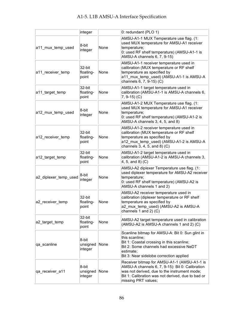
A1-5. L1B AMSU-A Interface Specification
86
integer 0: redundant (PLO 1)
a11_mux_temp_used 8-bit integer None
AMSU-A1-1 MUX Temperature use flag. (1: used MUX temperature for AMSU-A1 receiver temperature; 0: used RF shelf temperature) (AMSU-A1-1 is AMSU-A channels 6, 7, 9-15)
a11_receiver_temp 32-bit floating-point
None
AMSU-A1-1 receiver temperature used in calibration (MUX temperature or RF shelf temperature as specified by a11_mux_temp_used) (AMSU-A1-1 is AMSU-A channels 6, 7, 9-15) (C)
a11_target_temp 32-bit floating-point
None AMSU-A1-1 target temperature used in calibration (AMSU-A1-1 is AMSU-A channels 6, 7, 9-15) (C)
a12_mux_temp_used 8-bit integer None
AMSU-A1-2 MUX Temperature use flag. (1: used MUX temperature for AMSU-A1 receiver temperature; 0: used RF shelf temperature) (AMSU-A1-2 is AMSU-A channels 3, 4, 5, and 8)
a12_receiver_temp 32-bit floating-point
None
AMSU-A1-2 receiver temperature used in calibration (MUX temperature or RF shelf temperature as specified by a12_mux_temp_used) (AMSU-A1-2 is AMSU-A channels 3, 4, 5, and 8) (C)
a12_target_temp 32-bit floating-point
None AMSU-A1-2 target temperature used in calibration (AMSU-A1-2 is AMSU-A channels 3, 4, 5, and 8) (C)
a2_diplexer_temp_used 8-bit integer None
AMSU-A2 diplexer Temperature use flag. (1: used diplexer temperature for AMSU-A2 receiver temperature; 0: used RF shelf temperature) (AMSU-A2 is AMSU-A channels 1 and 2)
a2_receiver_temp 32-bit floating-point
None
AMSU-A2 receiver temperature used in calibration (diplexer temperature or RF shelf temperature as specified by a2_mux_temp_used) (AMSU-A2 is AMSU-A channels 1 and 2) (C)
a2_target_temp 32-bit floating-point
None AMSU-A2 target temperature used in calibration (AMSU-A2 is AMSU-A channels 1 and 2) (C)
qa_scanline 8-bit unsigned integer
None
Scanline bitmap for AMSU-A: Bit 0: Sun glint in this scanline; Bit 1: Coastal crossing in this scanline; Bit 2: Some channels had excessive NeDT estimate; Bit 3: Near sidelobe correction applied
qa_receiver_a11 8-bit unsigned integer
None
Receiver bitmap for AMSU-A1-1 (AMSU-A1-1 is AMSU-A channels 6, 7, 9-15): Bit 0: Calibration was not derived, due to the instrument mode; Bit 1: Calibration was not derived, due to bad or missing PRT values;

A1-5. L1B AMSU-A Interface Specification
87
Bit 2: This scanline was calibrated, but the moon was in the space view; Bit 3: This scanline was calibrated, but there was a space view scan position err; Bit 4: This scanline was calibrated, but there was a blackbody scan position error; Bit 5: This scanline was calibrated, but some PRT values were bad or marginal; Bit 6: This scanline was calibrated, but there was a data gap; Bit 7: Some channels were not calibrated
qa_receiver_a12 8-bit unsigned integer
None Receiver bitmap for AMSU-A1-2:Same fields as defined for qa_receiver_a11
qa_receiver_a2 8-bit unsigned integer
None Receiver bitmap for AMSU-A2:Same fields as defined for qa_receiver_a11
qa_channel 8-bit unsigned integer
Channel (= 15)
Channel bitmap for AMSU-A: Bit 0: All space view counts were bad for this channel and scanline; Bit 1: Space view counts were marginal for this channel and scanline; Bit 2: Space view counts could not be smoothed; Bit 3: All blackbody counts were bad for this channel and scanline; Bit 4: Blackbody counts were marginal for this channel and scanline; Bit 5: Blackbody counts could not be smoothed; Bit 6: Unable to calculate calibration coefficients for this scanline, most recent valid coefficients used instead; Bit 7: Excessive NeDT estimated
Size: 21330 bytes (0.0 MB) per 45-scanset granule
Full Swath Data Fields These fields appear for every footprint of every scanline in the granule (GeoTrack * GeoXTrack times)
Name Type Extra Dimensions Explanation
scanang 32-bit floating-point
None Scanning angle of AMSU-A instrument with respect to the AMSU-A Instrument for this footprint (-180.0 ... 180.0, negative at start of scan, 0 at nadir)
ftptgeoqa 32-bit unsigned integer
None
Footprint Geolocation QA flags: bit 0 (LSB): bad input value; bit 1: PGS_TD_TAItoUTC() returned PGSTD_E_NO_LEAP_SECS; bit 2: PGS_TD_TAItoUTC() returned PGS_E_TOOLKIT; bit 3: PGS_CSC_GetFOV_Pixel() returned PGSCSC_W_MISS_EARTH; bit 4: PGS_CSC_GetFOV_Pixel() returned PGSTD_E_SC_TAG_UNKNOWN; bit 5: PGS_CSC_GetFOV_Pixel() returned PGSCSC_W_ZERO_PIXEL_VECTOR;

A1-5. L1B AMSU-A Interface Specification
88
bit 6: PGS_CSC_GetFOV_Pixel() returned PGSCSC_W_BAD_EPH_FOR_PIXEL; bit 7: PGS_CSC_GetFOV_Pixel() returned PGSCSC_W_INSTRUMENT_OFF_BOARD; bit 8: PGS_CSC_GetFOV_Pixel() returned PGSCSC_W_BAD_ACCURACY_FLAG; bit 9: PGS_CSC_GetFOV_Pixel() returned PGSCSC_E_BAD_ARRAY_SIZE; bit 10: PGS_CSC_GetFOV_Pixel() returned PGSCSC_W_DEFAULT_EARTH_MODEL; bit 11: PGS_CSC_GetFOV_Pixel() returned PGSCSC_W_DATA_FILE_MISSING; bit 12: PGS_CSC_GetFOV_Pixel() returned PGSCSC_E_NEG_OR_ZERO_RAD; bit 13: PGS_CSC_GetFOV_Pixel() returned PGSMEM_E_NO_MEMORY; bit 14: PGS_CSC_GetFOV_Pixel() returned PGSTD_E_NO_LEAP_SECS; bit 15: PGS_CSC_GetFOV_Pixel() returned PGSTD_E_TIME_FMT_ERROR; bit 16: PGS_CSC_GetFOV_Pixel() returned PGSTD_E_TIME_VALUE_ERROR; bit 17: PGS_CSC_GetFOV_Pixel() returned PGSCSC_W_PREDICTED_UT1; bit 18: PGS_CSC_GetFOV_Pixel() returned PGSTD_E_NO_UT1_VALUE; bit 19: PGS_CSC_GetFOV_Pixel() returned PGS_E_TOOLKIT; bit 20: PGS_CSC_GetFOV_Pixel() returned PGSEPH_E_BAD_EPHEM_FILE_HDR; bit 21: PGS_CSC_GetFOV_Pixel() returned PGSEPH_E_NO_SC_EPHEM_FILE; bit 22-31: not used
zengeoqa 16-bit unsigned integer
None
Satellite zenith Geolocation QA flags: bit 0 (LSB): (Spacecraft) bad input value; bit 1: PGS_CSC_ZenithAzimuth(S/C) returned PGSCSC_W_BELOW_HORIZON; bit 2: PGS_CSC_ZenithAzimuth(S/C) returned PGSCSC_W_UNDEFINED_AZIMUTH; bit 3: PGS_CSC_ZenithAzimuth(S/C) returned PGSCSC_W_NO_REFRACTION; bit 4: PGS_CSC_ZenithAzimuth(S/C) returned PGSCSC_E_INVALID_VECTAG; bit 5: PGS_CSC_ZenithAzimuth(S/C) returned PGSCSC_E_LOOK_PT_ALTIT_RANGE; bit 6: PGS_CSC_ZenithAzimuth(S/C) returned PGSCSC_E_ZERO_INPUT_VECTOR; bit 7: PGS_CSC_ZenithAzimuth(S/C) returned PGS_E_TOOLKIT; bit 8: (Sun) bad input value; bit 9: (suppressed) PGS_CSC_ZenithAzimuth(Sun) returned PGSCSC_W_BELOW_HORIZON (This is not an error condition - the sun is below the horizon at night); bit 10: PGS_CSC_ZenithAzimuth(Sun) returned
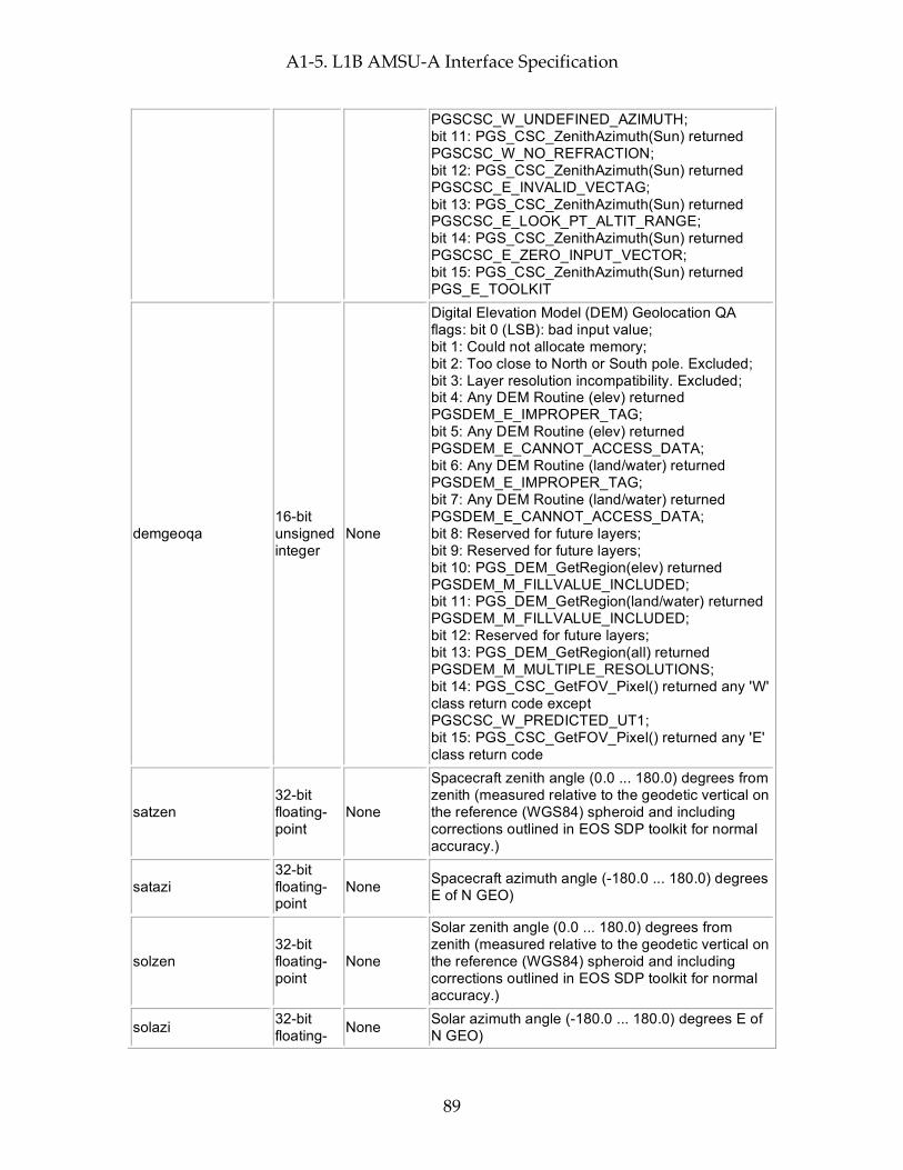
A1-5. L1B AMSU-A Interface Specification
89
PGSCSC_W_UNDEFINED_AZIMUTH; bit 11: PGS_CSC_ZenithAzimuth(Sun) returned PGSCSC_W_NO_REFRACTION; bit 12: PGS_CSC_ZenithAzimuth(Sun) returned PGSCSC_E_INVALID_VECTAG; bit 13: PGS_CSC_ZenithAzimuth(Sun) returned PGSCSC_E_LOOK_PT_ALTIT_RANGE; bit 14: PGS_CSC_ZenithAzimuth(Sun) returned PGSCSC_E_ZERO_INPUT_VECTOR; bit 15: PGS_CSC_ZenithAzimuth(Sun) returned PGS_E_TOOLKIT
demgeoqa 16-bit unsigned integer
None
Digital Elevation Model (DEM) Geolocation QA flags: bit 0 (LSB): bad input value; bit 1: Could not allocate memory; bit 2: Too close to North or South pole. Excluded; bit 3: Layer resolution incompatibility. Excluded; bit 4: Any DEM Routine (elev) returned PGSDEM_E_IMPROPER_TAG; bit 5: Any DEM Routine (elev) returned PGSDEM_E_CANNOT_ACCESS_DATA; bit 6: Any DEM Routine (land/water) returned PGSDEM_E_IMPROPER_TAG; bit 7: Any DEM Routine (land/water) returned PGSDEM_E_CANNOT_ACCESS_DATA; bit 8: Reserved for future layers; bit 9: Reserved for future layers; bit 10: PGS_DEM_GetRegion(elev) returned PGSDEM_M_FILLVALUE_INCLUDED; bit 11: PGS_DEM_GetRegion(land/water) returned PGSDEM_M_FILLVALUE_INCLUDED; bit 12: Reserved for future layers; bit 13: PGS_DEM_GetRegion(all) returned PGSDEM_M_MULTIPLE_RESOLUTIONS; bit 14: PGS_CSC_GetFOV_Pixel() returned any 'W' class return code except PGSCSC_W_PREDICTED_UT1; bit 15: PGS_CSC_GetFOV_Pixel() returned any 'E' class return code
satzen 32-bit floating-point
None
Spacecraft zenith angle (0.0 ... 180.0) degrees from zenith (measured relative to the geodetic vertical on the reference (WGS84) spheroid and including corrections outlined in EOS SDP toolkit for normal accuracy.)
satazi 32-bit floating-point
None Spacecraft azimuth angle (-180.0 ... 180.0) degrees E of N GEO)
solzen 32-bit floating-point
None
Solar zenith angle (0.0 ... 180.0) degrees from zenith (measured relative to the geodetic vertical on the reference (WGS84) spheroid and including corrections outlined in EOS SDP toolkit for normal accuracy.)
solazi 32-bit floating- None Solar azimuth angle (-180.0 ... 180.0) degrees E of
N GEO)
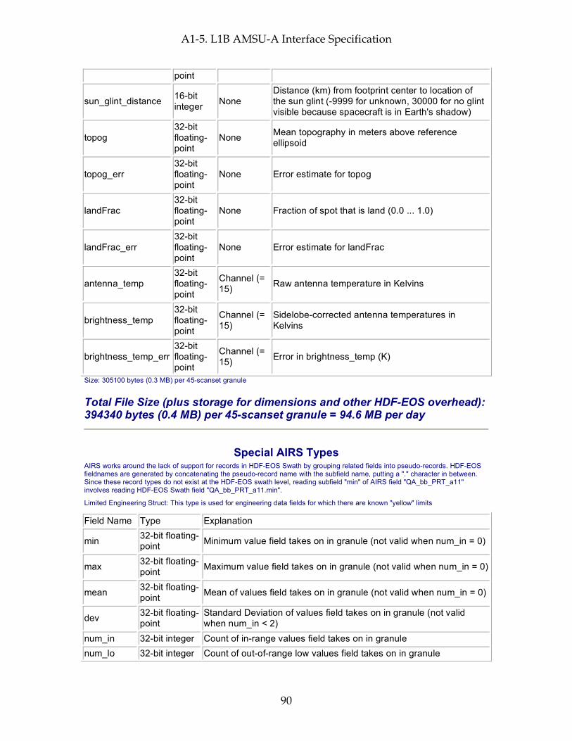
A1-5. L1B AMSU-A Interface Specification
90
point
sun_glint_distance 16-bit integer None
Distance (km) from footprint center to location of the sun glint (-9999 for unknown, 30000 for no glint visible because spacecraft is in Earth's shadow)
topog 32-bit floating-point
None Mean topography in meters above reference ellipsoid
topog_err 32-bit floating-point
None Error estimate for topog
landFrac 32-bit floating-point
None Fraction of spot that is land (0.0 ... 1.0)
landFrac_err 32-bit floating-point
None Error estimate for landFrac
antenna_temp 32-bit floating-point
Channel (= 15) Raw antenna temperature in Kelvins
brightness_temp 32-bit floating-point
Channel (= 15)
Sidelobe-corrected antenna temperatures in Kelvins
brightness_temp_err 32-bit floating-point
Channel (= 15) Error in brightness_temp (K)
Size: 305100 bytes (0.3 MB) per 45-scanset granule
Total File Size (plus storage for dimensions and other HDF-EOS overhead): 394340 bytes (0.4 MB) per 45-scanset granule = 94.6 MB per day
Special AIRS Types AIRS works around the lack of support for records in HDF-EOS Swath by grouping related fields into pseudo-records. HDF-EOS fieldnames are generated by concatenating the pseudo-record name with the subfield name, putting a "." character in between. Since these record types do not exist at the HDF-EOS swath level, reading subfield "min" of AIRS field "QA_bb_PRT_a11" involves reading HDF-EOS Swath field "QA_bb_PRT_a11.min".
Limited Engineering Struct: This type is used for engineering data fields for which there are known "yellow" limits
Field Name Type Explanation
min 32-bit floating-point Minimum value field takes on in granule (not valid when num_in = 0)
max 32-bit floating-point Maximum value field takes on in granule (not valid when num_in = 0)
mean 32-bit floating-point Mean of values field takes on in granule (not valid when num_in = 0)
dev 32-bit floating-point
Standard Deviation of values field takes on in granule (not valid when num_in < 2)
num_in 32-bit integer Count of in-range values field takes on in granule num_lo 32-bit integer Count of out-of-range low values field takes on in granule

A1-5. L1B AMSU-A Interface Specification
91
num_hi 32-bit integer Count of out-of-range high values field takes on in granule
num_bad 32-bit integer Count of occassions on which field takes on invalid flag value (-9999) in granule
range_min 32-bit floating-point Minimum in-range value.
range_max 32-bit floating-point Maximum in-range value.
missing 8-bit integer
Missing limits flags. Bit 0 (LSB) is 1 when yellow low (range_min) limit is missing; Bit 1 is high when yellow high (range_max) limit is missing; other bits unused, set to 0.
max_track 32-bit integer GeoTrack index (counting from 1) where max was found max_xtrack 32-bit integer GeoXTrack index (counting from 1) where max was found min_track 32-bit integer GeoTrack index (counting from 1) where min was found min_xtrack 32-bit integer GeoXTrack index (counting from 1) where min was found
Unlimited Engineering Struct: This type is used for engineering data fields for which there are NOT known "yellow" limits
Field Name Type Explanation
min 32-bit floating-point Minimum value field takes on in granule (not valid when num = 0)
max 32-bit floating-point Maximum value field takes on in granule (not valid when num = 0)
mean 32-bit floating-point Mean of values field takes on in granule (not valid when num = 0)
dev 32-bit floating-point
Standard Deviation of values field takes on in granule (not valid when num < 2)
num 32-bit integer Count of occurrences of field in granule (not including those counted in num_bad)
num_bad 32-bit integer Count of occassions on which field takes on invalid flag value (-9999) in granule
max_track 32-bit integer GeoTrack index (counting from 1) where max was found max_xtrack 32-bit integer GeoXTrack index (counting from 1) where max was found min_track 32-bit integer GeoTrack index (counting from 1) where min was found min_xtrack 32-bit integer GeoXTrack index (counting from 1) where min was found

A1-5. L1B AMSU-A Interface Specification
92
This page intentionally left blank.
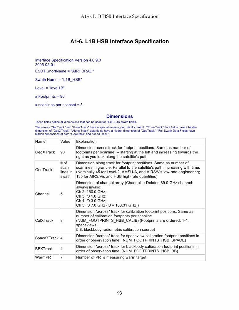
A1-6. L1B HSB Interface Specification
93
A1-6. L1B HSB Interface Specification
Interface Specification Version 4.0.9.0 2005-02-01
ESDT ShortName = "AIRHBRAD"
Swath Name = "L1B_HSB"
Level = "level1B"
# Footprints = 90
# scanlines per scanset = 3
Dimensions These fields define all dimensions that can be used for HDF-EOS swath fields.
The names "GeoTrack" and "GeoXTrack" have a special meaning for this document: "Cross-Track" data fields have a hidden dimension of "GeoXTrack"; "Along-Track" data fields have a hidden dimension of "GeoTrack"; "Full Swath Data Fields have hidden dimensions of both "GeoTrack" and "GeoXTrack".
Name Value Explanation
GeoXTrack 90 Dimension across track for footprint positions. Same as number of footprints per scanline. -- starting at the left and increasing towards the right as you look along the satellite's path
GeoTrack
# of scan lines in swath
Dimension along track for footprint positions. Same as number of scanlines in granule. Parallel to the satellite's path, increasing with time. (Nominally 45 for Level-2, AMSU-A, and AIRS/Vis low-rate engineering; 135 for AIRS/Vis and HSB high-rate quantities)
Channel 5
Dimension of channel array (Channel 1: Deleted 89.0 GHz channel: always invalid; Ch 2: 150.0 GHz; Ch 3: f0 1.0 GHz; Ch 4: f0 3.0 GHz; Ch 5: f0 7.0 GHz (f0 = 183.31 GHz))
CalXTrack 8
Dimension "across" track for calibration footprint positions. Same as number of calibration footprints per scanline. (NUM_FOOTPRINTS_HSB_CALIB) (Footprints are ordered: 1-4: spaceviews; 5-8: blackbody radiometric calibration source)
SpaceXTrack 4 Dimension "across" track for spaceview calibration footprint positions in order of observation time. (NUM_FOOTPRINTS_HSB_SPACE)
BBXTrack 4 Dimension "across" track for blackbody calibration footprint positions in order of observation time. (NUM_FOOTPRINTS_HSB_BB)
WarmPRT 7 Number of PRTs measuring warm target

A1-6. L1B HSB Interface Specification
94
Geolocation Fields These fields appear for every footprint (GeoTrack * GeoXTrack times) and correspond to footprint center coordinates and "shutter" time.
Name Explanation Latitude Footprint boresight geodetic Latitude in degrees North (-90.0 ... 90.0) Longitude Footprint boresight geodetic Longitude in degrees East (-180.0 ... 180.0) Time Footprint "shutter" TAI Time: floating-point elapsed seconds since Jan 1, 1993 Size: 291600 bytes (0.3 MB) per 45-scanset granule
Attributes These fields appear only once per granule and use the HDF-EOS "Attribute" interface
Name Type Explanation
processing_level string of 8-bit characters
Zero-terminated character string denoting processing level ("level1B")
instrument string of 8-bit characters
Zero-terminated character string denoting instrument ("HSB")
DayNightFlag string of 8-bit characters
Zero-terminated character string set to "Night" when the subsatellite points at the beginning and end of a granule are both experiencing night according to the "civil twilight" standard (center of refracted sun is more than 6 degrees below the horizon). It is set to "Day" when both are experiencing day, and "Both" when one is experiencing day and the other night. "NA" is used when a determination cannot be made.
AutomaticQAFlag string of 8-bit characters
Zero-terminated character string denoting granule data quality: (Always "Passed", "Failed", or "Suspect")
NumTotalData 32-bit integer Total number of expected channels * scene FOVs
NumProcessData 32-bit integer
Number of channels * scene FOVs which are present and can be processed routinely (state = 0)
NumSpecialData 32-bit integer
Number of channels * scene FOVs which are present and can be processed only as a special test (state = 1)
NumBadData 32-bit integer
Number of channels * scene FOVs which are present but cannot be processed (state = 2)
NumMissingData 32-bit integer
Number of expected channels * scene FOVs which are not present (state = 3)
NumLandSurface 32-bit integer
Number of scene footprints for which the surface is more than 90% land
NumOceanSurface 32-bit integer
Number of scene footprints for which the surface is less than 10% land

A1-6. L1B HSB Interface Specification
95
node_type string of 8-bit characters
Zero-terminated character string denoting whether granule is ascending, descending, or pole-crossing: ("Ascending" and "Descending" for entirely ascending or entirely descending granules, or "NorthPole" or "SouthPole" for pole-crossing granules. "NA" when determination cannot be made.)
start_year 32-bit integer Year in which granule started, UTC (e.g. 1999)
start_month 32-bit integer Month in which granule started, UTC (1 ... 12)
start_day 32-bit integer
Day of month in which granule started, UTC (1 ... 31)
start_hour 32-bit integer
Hour of day in which granule started, UTC (0 ... 23)
start_minute 32-bit integer
Minute of hour in which granule started, UTC (0 ... 59)
start_sec 32-bit floating-point
Second of minute in which granule started, UTC (0.0 ... 59.0)
start_orbit 32-bit integer Orbit number of mission in which granule started
end_orbit 32-bit integer Orbit number of mission in which granule ended
orbit_path 32-bit integer
Orbit path of start orbit (1 ... 233 as defined by EOS project)
start_orbit_row 32-bit integer
Orbit row at start of granule (1 ... 248 as defined by EOS project)
end_orbit_row 32-bit integer
Orbit row at end of granule (1 ... 248 as defined by EOS project)
granule_number 32-bit integer Number of granule within day (1 ... 240)
num_scansets 32-bit integer Number of scansets in granule (1 ... 45)
num_scanlines 32-bit integer
Number of scanlines in granule (3 * num_scansets)
start_Latitude 64-bit floating-point
Geodetic Latitude of spacecraft at start of granule in degrees North (-90.0 ... 90.0)
start_Longitude 64-bit floating-point
Geodetic Longitude of spacecraft at start of granule in degrees East (-180.0 ... 180.0)
start_Time 64-bit floating-point
TAI Time at start of granule (floating-point elapsed seconds since start of 1993)
end_Latitude 64-bit floating-point
Geodetic Latitude of spacecraft at end of granule in degrees North (-90.0 ... 90.0)

A1-6. L1B HSB Interface Specification
96
end_Longitude 64-bit floating-point
Geodetic Longitude of spacecraft at end of granule in degrees East (-180.0 ... 180.0)
end_Time 64-bit floating-point
TAI Time at end of granule (floating-point elapsed seconds since start of 1993)
eq_x_longitude 32-bit floating-point
Longitude of spacecraft at southward equator crossing nearest granule start in degrees East (-180.0 ... 180.0)
eq_x_tai 64-bit floating-point
Time of eq_x_longitude in TAI units (floating-point elapsed seconds since start of 1993)
orbitgeoqa 32-bit unsigned integer
Orbit Geolocation QA: bit 0 (LSB): bad input value (last scanline); bit 1: bad input value (first scanline); bit 2: PGS_EPH_GetEphMet() returned PGSEPH_E_NO_SC_EPHEM_FILE; bit 3: PGS_EPH_GetEphMet() returned PGSEPH_E_BAD_ARRAY_SIZE; bit 4: PGS_EPH_GetEphMet() returned PGSTD_E_TIME_FMT_ERROR; bit 5: PGS_EPH_GetEphMet() returned PGSTD_E_TIME_VALUE_ERROR; bit 6: PGS_EPH_GetEphMet() returned PGSTD_E_SC_TAG_UNKNOWN; bit 7: PGS_EPH_GetEphMet() returned PGS_E_TOOLKIT; bit 8: PGS_TD_UTCtoTAI() returned PGSTD_E_NO_LEAP_SECS; bit 9: PGS_TD_UTCtoTAI() returned PGSTD_E_TIME_FMT_ERROR; bit 10: PGS_TD_UTCtoTAI() returned PGSTD_E_TIME_VALUE_ERROR; bit 11: PGS_TD_UTCtoTAI() returned PGS_E_TOOLKIT; bit 12: PGS_CSC_DayNight() returned PGSTD_E_NO_LEAP_SECS; bit 13: PGS_CSC_DayNight() returned PGSCSC_E_INVALID_LIMITTAG; bit 14: PGS_CSC_DayNight() returned PGSCSC_E_BAD_ARRAY_SIZE; bit 15: PGS_CSC_DayNight() returned PGSCSC_W_ERROR_IN_DAYNIGHT; bit 16: PGS_CSC_DayNight() returned PGSCSC_W_BAD_TRANSFORM_VALUE; bit 17: PGS_CSC_DayNight() returned PGSCSC_W_BELOW_HORIZON; bit 18: PGS_CSC_DayNight() returned PGSCSC_W_PREDICTED_UT1; bit 19: PGS_CSC_DayNight() returned PGSTD_E_NO_UT1_VALUE; bit 20: PGS_CSC_DayNight() returned PGSTD_E_BAD_INITIAL_TIME; bit 21: PGS_CSC_DayNight() returned

A1-6. L1B HSB Interface Specification
97
PGSCBP_E_TIME_OUT_OF_RANGE; bit 22: PGS_CSC_DayNight() returned PGSCBP_E_UNABLE_TO_OPEN_FILE; bit 22: PGS_CSC_DayNight() returned PGSMEM_E_NO_MEMORY; bit 24: PGS_CSC_DayNight() returned PGS_E_TOOLKIT; bit 25-31: not used
num_satgeoqa 16-bit integer Number of scans with problems in satgeoqa
num_glintgeoqa 16-bit integer Number of scans with problems in glintgeoqa
num_moongeoqa 16-bit integer Number of scans with problems in moongeoqa
num_ftptgeoqa 16-bit integer Number of footprints with problems in ftptgeoqa
num_zengeoqa 16-bit integer Number of footprints with problems in zengeoqa
num_demgeoqa 16-bit integer Number of footprints with problems in demgeoqa
num_fpe 16-bit integer Number of floating point errors
LonGranuleCen 16-bit integer
Geodetic Longitude of the center of the granule in degrees East (-180 ... 180)
LatGranuleCen 16-bit integer
Geodetic Latitude of the center of the granule in degrees North (-90 ... 90)
LocTimeGranuleCen 16-bit integer
Local solar time at the center of the granule in minutes past midnight (0 ... 1439)
num_scanlines_not_norm_mode 32-bit integer Number of scanlines not in Process state
num_missing_scanlines 32-bit integer Number of scanlines with state = missing
num_data_gaps 32-bit integer
Number of blocks of scanlines where State is not Process
num_instr_mode_changes 32-bit integer Number of operational instrument mode changes
num_scanlines_rec_cal_prob 32-bit integer Number of scanlines with non-zero qa_receiver
num_scanlines_sig_coast_xing 32-bit integer
Number of scanlines with qa_scanline coast crossing bit set
num_scanlines_sig_sun_glint 32-bit integer
Number of scanlines with qa_scanline sun glint bit set
MoonInViewMWCount 32-bit integer
Number of scanlines in granule with the moon in the HSB space view
QA_bb_PRT
Limited Engineering Struct (see below)
Blackbody PRT temperature summary QA (C)

A1-6. L1B HSB Interface Specification
98
QA_rec_PRT
Limited Engineering Struct (see below)
Receiver PRT temperature summary QA (C)
granules_present string of 8-bit characters
Zero-terminated character string denoting which adjacent granules were available for smoothing ("All" for both previous & next, "Prev" for previous but not next, "Next" for next but not previous, "None" for neither previous nor next)
Size: 366 bytes (0.0 MB) per granule
Per-Granule Data Fields These fields appear only once per granule and use the HDF-EOS "Field" interface
Name Type Extra Dimensions Explanation
center_freq 32-bit floating-point Channel (= 5) Channel Center frequency
(GHz)
IF_offset_1 32-bit floating-point Channel (= 5)
Offset of first intermediate frequency stage (MHz) (zero for no mixing)
IF_offset_2 32-bit floating-point Channel (= 5)
Offset of second intermediate frequency stage (MHz) (zero for no second mixing)
bandwidth 32-bit floating-point Channel (= 5) Bandwidth of sum of 1, 2,
or 4 channels (MHz)
num_calibrated_scanlines 32-bit integer Channel (= 5) Number of scanlines that had calibration coefs applied
num_scanlines_ch_cal_problems 32-bit integer Channel (= 5) Number of scanlines with non-zero qa_channel
QA_unfiltered_scene_count
Unlimited Engineering Struct (see below)
GeoXTrack (= 90) * Channel (= 5)
Per footprint position raw scene count summary QA
QA_unfiltered_BB_count
Unlimited Engineering Struct (see below)
BBXTrack (= 4) * Channel (= 5)
Per BB footprint position raw warm count summary QA (unfiltered)
QA_unfiltered_space_count
Unlimited Engineering Struct (see below)
SpaceXTrack (= 4) * Channel (= 5)
Per space footprint position raw cold count summary QA (unfiltered)
QA_cal_coef_a0
Unlimited Engineering Struct (see below)
Channel (= 5) Calibration coefficient a0 summary QA (K)
QA_cal_coef_a1 Unlimited Engineering Struct (see
Channel (= 5) Calibration coefficient a1 summary QA (K/count)
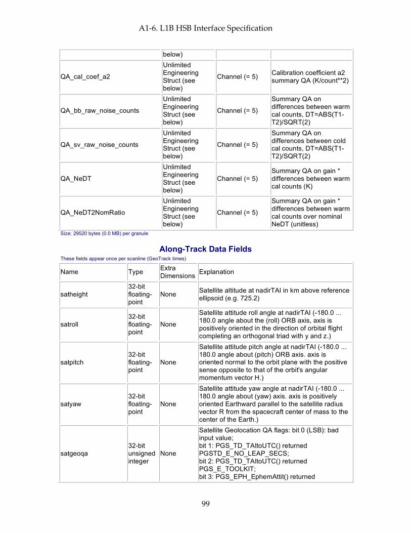
A1-6. L1B HSB Interface Specification
99
below)
QA_cal_coef_a2
Unlimited Engineering Struct (see below)
Channel (= 5) Calibration coefficient a2 summary QA (K/count**2)
QA_bb_raw_noise_counts
Unlimited Engineering Struct (see below)
Channel (= 5)
Summary QA on differences between warm cal counts, DT=ABS(T1-T2)/SQRT(2)
QA_sv_raw_noise_counts
Unlimited Engineering Struct (see below)
Channel (= 5)
Summary QA on differences between cold cal counts, DT=ABS(T1-T2)/SQRT(2)
QA_NeDT
Unlimited Engineering Struct (see below)
Channel (= 5) Summary QA on gain * differences between warm cal counts (K)
QA_NeDT2NomRatio
Unlimited Engineering Struct (see below)
Channel (= 5)
Summary QA on gain * differences between warm cal counts over nominal NeDT (unitless)
Size: 29520 bytes (0.0 MB) per granule
Along-Track Data Fields These fields appear once per scanline (GeoTrack times)
Name Type Extra Dimensions Explanation
satheight 32-bit floating-point
None Satellite altitude at nadirTAI in km above reference ellipsoid (e.g. 725.2)
satroll 32-bit floating-point
None
Satellite attitude roll angle at nadirTAI (-180.0 ... 180.0 angle about the (roll) ORB axis, axis is positively oriented in the direction of orbital flight completing an orthogonal triad with y and z.)
satpitch 32-bit floating-point
None
Satellite attitude pitch angle at nadirTAI (-180.0 ... 180.0 angle about (pitch) ORB axis. axis is oriented normal to the orbit plane with the positive sense opposite to that of the orbit's angular momentum vector H.)
satyaw 32-bit floating-point
None
Satellite attitude yaw angle at nadirTAI (-180.0 ... 180.0 angle about (yaw) axis. axis is positively oriented Earthward parallel to the satellite radius vector R from the spacecraft center of mass to the center of the Earth.)
satgeoqa 32-bit unsigned integer
None
Satellite Geolocation QA flags: bit 0 (LSB): bad input value; bit 1: PGS_TD_TAItoUTC() returned PGSTD_E_NO_LEAP_SECS; bit 2: PGS_TD_TAItoUTC() returned PGS_E_TOOLKIT; bit 3: PGS_EPH_EphemAttit() returned

A1-6. L1B HSB Interface Specification
100
PGSEPH_W_BAD_EPHEM_VALUE; bit 4: PGS_EPH_EphemAttit() returned PGSEPH_E_BAD_EPHEM_FILE_HDR; bit 5: PGS_EPH_EphemAttit() returned PGSEPH_E_NO_SC_EPHEM_FILE; bit 6: PGS_EPH_EphemAttit() returned PGSEPH_E_NO_DATA_REQUESTED; bit 7: PGS_EPH_EphemAttit() returned PGSTD_E_SC_TAG_UNKNOWN; bit 8: PGS_EPH_EphemAttit() returned PGSEPH_E_BAD_ARRAY_SIZE; bit 9: PGS_EPH_EphemAttit() returned PGSTD_E_TIME_FMT_ERROR; bit 10: PGS_EPH_EphemAttit() returned PGSTD_E_TIME_VALUE_ERROR; bit 11: PGS_EPH_EphemAttit() returned PGSTD_E_NO_LEAP_SECS; bit 12: PGS_EPH_EphemAttit() returned PGS_E_TOOLKIT; bit 13: PGS_CSC_ECItoECR() returned PGSCSC_W_BAD_TRANSFORM_VALUE; bit 14: PGS_CSC_ECItoECR() returned PGSCSC_E_BAD_ARRAY_SIZE; bit 15: PGS_CSC_ECItoECR() returned PGSTD_E_NO_LEAP_SECS; bit 16: PGS_CSC_ECItoECR() returned PGSTD_E_TIME_FMT_ERROR; bit 17: PGS_CSC_ECItoECR() returned PGSTD_E_TIME_VALUE_ERROR; bit 18: unused (set to zero); bit 19: PGS_CSC_ECItoECR() returned PGSTD_E_NO_UT1_VALUE; bit 20: PGS_CSC_ECItoECR() returned PGS_E_TOOLKIT; bit 21: PGS_CSC_ECRtoGEO() returned PGSCSC_W_TOO_MANY_ITERS; bit 22: PGS_CSC_ECRtoGEO() returned PGSCSC_W_INVALID_ALTITUDE; bit 23: PGS_CSC_ECRtoGEO() returned PGSCSC_W_SPHERE_BODY; bit 24: PGS_CSC_ECRtoGEO() returned PGSCSC_W_LARGE_FLATTENING; bit 25: PGS_CSC_ECRtoGEO() returned PGSCSC_W_DEFAULT_EARTH_MODEL; bit 26: PGS_CSC_ECRtoGEO() returned PGSCSC_E_BAD_EARTH_MODEL; bit 27: PGS_CSC_ECRtoGEO() returned PGS_E_TOOLKIT; bit 28-31: not used
glintgeoqa 16-bit unsigned integer
None
Glint Geolocation QA flags: bit 0 (LSB): bad input value; bit 1: glint location in Earth's shadow; bit 2: glint calculation not converging; bit 3: glint location sun vs. satellite zenith mismatch;

A1-6. L1B HSB Interface Specification
101
bit 4: glint location sun vs. satellite azimuth mismatch; bit 5: bad glint location; bit 6: PGS_CSC_ZenithAzimuth() returned any 'W' class return code; bit 7: PGS_CSC_ZenithAzimuth() returned any 'E' class return code; bit 8: PGS_CBP_Earth_CB_Vector() returned returned any 'W' class return code; bit 9: PGS_CBP_Earth_CB_Vector() returned returned any 'E' class return code; bit 10: PGS_CSC_ECItoECR() returned any 'W' class return code except PGSCSC_W_PREDICTED_UT1 (for Glint); bit 11: PGS_CSC_ECItoECR() returned any 'E' class return code (for Glint); bit 12: PGS_CSC_ECRtoGEO() returned any 'W' class return code (for Glint); bit 13: PGS_CSC_ECRtoGEO() returned any 'E' class return code (for Glint); bit 14: PGS_CSC_ECItoECR() returned any 'W' class return code except PGSCSC_W_PREDICTED_UT1 ; bit 15: PGS_CSC_ECItoECR() returned any 'E' class return code
moongeoqa 16-bit unsigned integer
None
Moon Geolocation QA flags: bit 0 (LSB): bad input value; bit 1: PGS_TD_TAItoUTC() returned PGSTD_E_NO_LEAP_SECS; bit 2: PGS_TD_TAItoUTC() returned PGS_E_TOOLKIT; bit 3: PGS_CBP_Sat_CB_Vector() returned PGSCSC_W_BELOW_SURFACE; bit 4: PGS_CBP_Sat_CB_Vector() returned PGSCBP_W_BAD_CB_VECTOR; bit 5: PGS_CBP_Sat_CB_Vector() returned PGSCBP_E_BAD_ARRAY_SIZE; bit 6: PGS_CBP_Sat_CB_Vector() returned PGSCBP_E_INVALID_CB_ID; bit 7: PGS_CBP_Sat_CB_Vector() returned PGSMEM_E_NO_MEMORY; bit 8: PGS_CBP_Sat_CB_Vector() returned PGSCBP_E_UNABLE_TO_OPEN_FILE; bit 9: PGS_CBP_Sat_CB_Vector() returned PGSTD_E_BAD_INITIAL_TIME; bit 10: PGS_CBP_Sat_CB_Vector() returned PGSCBP_E_TIME_OUT_OF_RANGE; bit 11: PGS_CBP_Sat_CB_Vector() returned PGSTD_E_SC_TAG_UNKNOWN; bit 12: PGS_CBP_Sat_CB_Vector() returned PGSEPH_E_BAD_EPHEM_FILE_HDR; bit 13: PGS_CBP_Sat_CB_Vector() returned PGSEPH_E_NO_SC_EPHEM_FILE; bit 14: PGS_CBP_Sat_CB_Vector() returned PGS_E_TOOLKIT;

A1-6. L1B HSB Interface Specification
102
bit 15: not used
nadirTAI 64-bit floating-point
None
TAI time at which instrument is nominally looking directly down. (between footprints 15 & 16 for AMSU or between footprints 45 & 46 for AIRS/Vis & HSB) (floating-point elapsed seconds since start of 1993)
sat_lat 64-bit floating-point
None Satellite geodetic latitude in degrees North (-90.0 ... 90.0)
sat_lon 64-bit floating-point
None Satellite geodetic longitude in degrees East (-180.0 ... 180.0)
scan_node_type 8-bit integer None 'A' for ascending, 'D' for descending, 'N' for North-
Polar, 'S' for South-Polar
glintlat 32-bit floating-point
None Solar glint geodetic latitude in degrees North at nadirTAI (-90.0 ... 90.0)
glintlon 32-bit floating-point
None Solar glint geodetic longitude in degrees East at nadirTAI (-180.0 ... 180.0)
state 32-bit integer None Data state: 0:Process, 1:Special, 2:Erroneous,
3:Missing
cal_coef_a0 32-bit floating-point
Channel (= 5)
Calibration coefficients to convert raw counts to antenna temperature (K)
cal_coef_a1 32-bit floating-point
Channel (= 5)
Calibration coefficients to convert raw counts to antenna temperature (K/count)
cal_coef_a2 32-bit floating-point
Channel (= 5)
Calibration coefficients to convert raw counts to antenna temperature (K/count**2)
cal_coef_a0_err 32-bit floating-point
Channel (= 5) Error estimate for cal_coef_a0 (K)
cal_coef_a1_err 32-bit floating-point
Channel (= 5) Error estimate for cal_coef_a1 (K/count)
cal_coef_a2_err 32-bit floating-point
Channel (= 5) Error estimate for cal_coef_a2 (K/count**2)
SpacViewSelct 8-bit integer None Space View Selected
mixer_17_temp_used 8-bit integer None
Mixer 17 Temperature use flag. (1: used mixer 17 temperature for receiver temperature; 0: used mixer 18/19/20 temperature)
receiver_temp 32-bit floating-point
None Receiver temperature used in calibration (mixer 17 temperature or mixer 18/19/20 temperature as specified by mixer_17_temp_used) (C)
target_temp 32-bit None HSB target temperature used in calibration (C)

A1-6. L1B HSB Interface Specification
103
floating-point
qa_scanline 8-bit unsigned integer
None
Scanline bitmap for HSB: Bit 0: Sun glint in this scanline; Bit 1: Coastal crossing in this scanline; Bit 2: Some channels had excessive NeDT estimate; Bit 3: Near sidelobe correction applied
qa_receiver 8-bit unsigned integer
None
Receiver bitmap for HSB: Bit 0: Calibration was not derived, due to the instrument mode; Bit 1: Calibration was not derived, due to bad or missing PRT values; Bit 2: This scanline was calibrated, but the moon was in the space view; Bit 3: This scanline was calibrated, but there was a space view scan position err; Bit 4: This scanline was calibrated, but there was a blackbody scan position error; Bit 5: This scanline was calibrated, but some PRT values were bad or marginal; Bit 6: This scanline was calibrated, but there was a data gap; Bit 7: Some channels were not calibrated
qa_channel 8-bit unsigned integer
Channel (= 5)
Channel bitmap for HSB: Bit 0: All space view counts were bad for this channel and scanline; Bit 1: Space view counts were marginal for this channel and scanline; Bit 2: Space view counts could not be smoothed; Bit 3: All blackbody counts were bad for this channel and scanline; Bit 4: Blackbody counts were marginal for this channel and scanline; Bit 5: Blackbody counts could not be smoothed; Bit 6: Most recent calibration coefficients used; Bit 7: Excessive NeDT estimated
Size: 26730 bytes (0.0 MB) per 45-scanset granule
Full Swath Data Fields These fields appear for every footprint of every scanline in the granule (GeoTrack * GeoXTrack times)
Name Type Extra Dimensions Explanation
scanang 32-bit floating-point
None Scanning angle of HSB instrument with respect to the HSB instrument for this footprint (-180.0 ... 180.0, negative at start of scan, 0 at nadir)
ftptgeoqa 32-bit unsigned integer
None
Footprint Geolocation QA flags: bit 0 (LSB): bad input value; bit 1: PGS_TD_TAItoUTC() returned PGSTD_E_NO_LEAP_SECS; bit 2: PGS_TD_TAItoUTC() returned PGS_E_TOOLKIT; bit 3: PGS_CSC_GetFOV_Pixel() returned PGSCSC_W_MISS_EARTH; bit 4: PGS_CSC_GetFOV_Pixel() returned
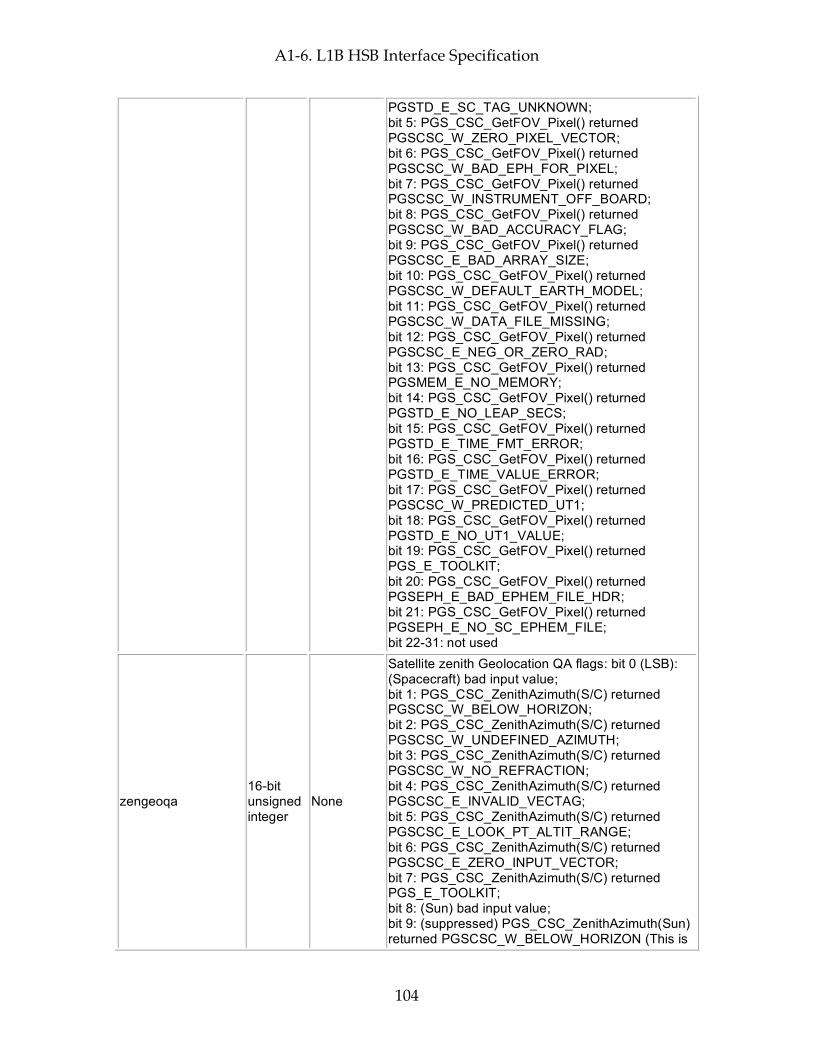
A1-6. L1B HSB Interface Specification
104
PGSTD_E_SC_TAG_UNKNOWN; bit 5: PGS_CSC_GetFOV_Pixel() returned PGSCSC_W_ZERO_PIXEL_VECTOR; bit 6: PGS_CSC_GetFOV_Pixel() returned PGSCSC_W_BAD_EPH_FOR_PIXEL; bit 7: PGS_CSC_GetFOV_Pixel() returned PGSCSC_W_INSTRUMENT_OFF_BOARD; bit 8: PGS_CSC_GetFOV_Pixel() returned PGSCSC_W_BAD_ACCURACY_FLAG; bit 9: PGS_CSC_GetFOV_Pixel() returned PGSCSC_E_BAD_ARRAY_SIZE; bit 10: PGS_CSC_GetFOV_Pixel() returned PGSCSC_W_DEFAULT_EARTH_MODEL; bit 11: PGS_CSC_GetFOV_Pixel() returned PGSCSC_W_DATA_FILE_MISSING; bit 12: PGS_CSC_GetFOV_Pixel() returned PGSCSC_E_NEG_OR_ZERO_RAD; bit 13: PGS_CSC_GetFOV_Pixel() returned PGSMEM_E_NO_MEMORY; bit 14: PGS_CSC_GetFOV_Pixel() returned PGSTD_E_NO_LEAP_SECS; bit 15: PGS_CSC_GetFOV_Pixel() returned PGSTD_E_TIME_FMT_ERROR; bit 16: PGS_CSC_GetFOV_Pixel() returned PGSTD_E_TIME_VALUE_ERROR; bit 17: PGS_CSC_GetFOV_Pixel() returned PGSCSC_W_PREDICTED_UT1; bit 18: PGS_CSC_GetFOV_Pixel() returned PGSTD_E_NO_UT1_VALUE; bit 19: PGS_CSC_GetFOV_Pixel() returned PGS_E_TOOLKIT; bit 20: PGS_CSC_GetFOV_Pixel() returned PGSEPH_E_BAD_EPHEM_FILE_HDR; bit 21: PGS_CSC_GetFOV_Pixel() returned PGSEPH_E_NO_SC_EPHEM_FILE; bit 22-31: not used
zengeoqa 16-bit unsigned integer
None
Satellite zenith Geolocation QA flags: bit 0 (LSB): (Spacecraft) bad input value; bit 1: PGS_CSC_ZenithAzimuth(S/C) returned PGSCSC_W_BELOW_HORIZON; bit 2: PGS_CSC_ZenithAzimuth(S/C) returned PGSCSC_W_UNDEFINED_AZIMUTH; bit 3: PGS_CSC_ZenithAzimuth(S/C) returned PGSCSC_W_NO_REFRACTION; bit 4: PGS_CSC_ZenithAzimuth(S/C) returned PGSCSC_E_INVALID_VECTAG; bit 5: PGS_CSC_ZenithAzimuth(S/C) returned PGSCSC_E_LOOK_PT_ALTIT_RANGE; bit 6: PGS_CSC_ZenithAzimuth(S/C) returned PGSCSC_E_ZERO_INPUT_VECTOR; bit 7: PGS_CSC_ZenithAzimuth(S/C) returned PGS_E_TOOLKIT; bit 8: (Sun) bad input value; bit 9: (suppressed) PGS_CSC_ZenithAzimuth(Sun) returned PGSCSC_W_BELOW_HORIZON (This is
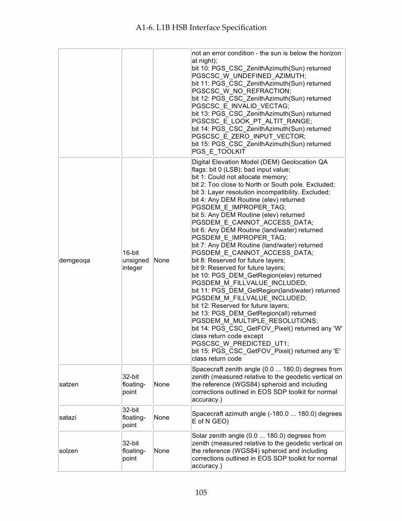
A1-6. L1B HSB Interface Specification
105
not an error condition - the sun is below the horizon at night); bit 10: PGS_CSC_ZenithAzimuth(Sun) returned PGSCSC_W_UNDEFINED_AZIMUTH; bit 11: PGS_CSC_ZenithAzimuth(Sun) returned PGSCSC_W_NO_REFRACTION; bit 12: PGS_CSC_ZenithAzimuth(Sun) returned PGSCSC_E_INVALID_VECTAG; bit 13: PGS_CSC_ZenithAzimuth(Sun) returned PGSCSC_E_LOOK_PT_ALTIT_RANGE; bit 14: PGS_CSC_ZenithAzimuth(Sun) returned PGSCSC_E_ZERO_INPUT_VECTOR; bit 15: PGS_CSC_ZenithAzimuth(Sun) returned PGS_E_TOOLKIT
demgeoqa 16-bit unsigned integer
None
Digital Elevation Model (DEM) Geolocation QA flags: bit 0 (LSB): bad input value; bit 1: Could not allocate memory; bit 2: Too close to North or South pole. Excluded; bit 3: Layer resolution incompatibility. Excluded; bit 4: Any DEM Routine (elev) returned PGSDEM_E_IMPROPER_TAG; bit 5: Any DEM Routine (elev) returned PGSDEM_E_CANNOT_ACCESS_DATA; bit 6: Any DEM Routine (land/water) returned PGSDEM_E_IMPROPER_TAG; bit 7: Any DEM Routine (land/water) returned PGSDEM_E_CANNOT_ACCESS_DATA; bit 8: Reserved for future layers; bit 9: Reserved for future layers; bit 10: PGS_DEM_GetRegion(elev) returned PGSDEM_M_FILLVALUE_INCLUDED; bit 11: PGS_DEM_GetRegion(land/water) returned PGSDEM_M_FILLVALUE_INCLUDED; bit 12: Reserved for future layers; bit 13: PGS_DEM_GetRegion(all) returned PGSDEM_M_MULTIPLE_RESOLUTIONS; bit 14: PGS_CSC_GetFOV_Pixel() returned any 'W' class return code except PGSCSC_W_PREDICTED_UT1; bit 15: PGS_CSC_GetFOV_Pixel() returned any 'E' class return code
satzen 32-bit floating-point
None
Spacecraft zenith angle (0.0 ... 180.0) degrees from zenith (measured relative to the geodetic vertical on the reference (WGS84) spheroid and including corrections outlined in EOS SDP toolkit for normal accuracy.)
satazi 32-bit floating-point
None Spacecraft azimuth angle (-180.0 ... 180.0) degrees E of N GEO)
solzen 32-bit floating-point
None
Solar zenith angle (0.0 ... 180.0) degrees from zenith (measured relative to the geodetic vertical on the reference (WGS84) spheroid and including corrections outlined in EOS SDP toolkit for normal accuracy.)
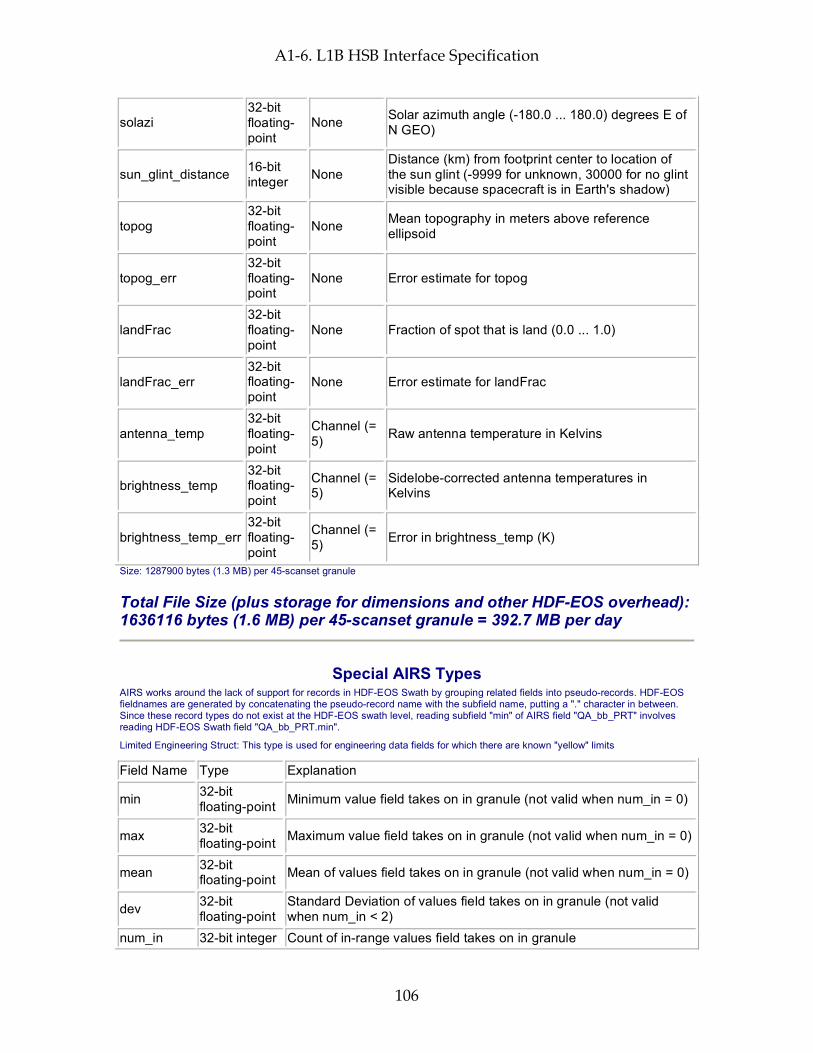
A1-6. L1B HSB Interface Specification
106
solazi 32-bit floating-point
None Solar azimuth angle (-180.0 ... 180.0) degrees E of N GEO)
sun_glint_distance 16-bit integer None
Distance (km) from footprint center to location of the sun glint (-9999 for unknown, 30000 for no glint visible because spacecraft is in Earth's shadow)
topog 32-bit floating-point
None Mean topography in meters above reference ellipsoid
topog_err 32-bit floating-point
None Error estimate for topog
landFrac 32-bit floating-point
None Fraction of spot that is land (0.0 ... 1.0)
landFrac_err 32-bit floating-point
None Error estimate for landFrac
antenna_temp 32-bit floating-point
Channel (= 5) Raw antenna temperature in Kelvins
brightness_temp 32-bit floating-point
Channel (= 5)
Sidelobe-corrected antenna temperatures in Kelvins
brightness_temp_err 32-bit floating-point
Channel (= 5) Error in brightness_temp (K)
Size: 1287900 bytes (1.3 MB) per 45-scanset granule
Total File Size (plus storage for dimensions and other HDF-EOS overhead): 1636116 bytes (1.6 MB) per 45-scanset granule = 392.7 MB per day
Special AIRS Types AIRS works around the lack of support for records in HDF-EOS Swath by grouping related fields into pseudo-records. HDF-EOS fieldnames are generated by concatenating the pseudo-record name with the subfield name, putting a "." character in between. Since these record types do not exist at the HDF-EOS swath level, reading subfield "min" of AIRS field "QA_bb_PRT" involves reading HDF-EOS Swath field "QA_bb_PRT.min".
Limited Engineering Struct: This type is used for engineering data fields for which there are known "yellow" limits
Field Name Type Explanation
min 32-bit floating-point Minimum value field takes on in granule (not valid when num_in = 0)
max 32-bit floating-point Maximum value field takes on in granule (not valid when num_in = 0)
mean 32-bit floating-point Mean of values field takes on in granule (not valid when num_in = 0)
dev 32-bit floating-point
Standard Deviation of values field takes on in granule (not valid when num_in < 2)
num_in 32-bit integer Count of in-range values field takes on in granule
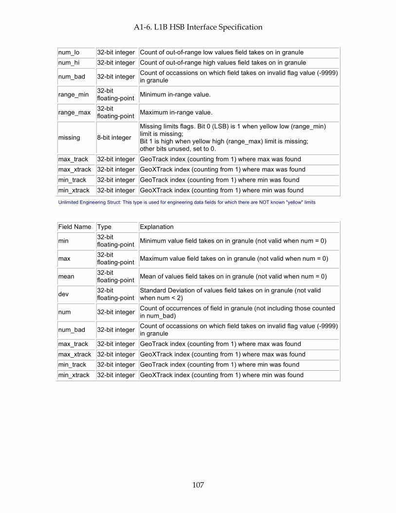
A1-6. L1B HSB Interface Specification
107
num_lo 32-bit integer Count of out-of-range low values field takes on in granule num_hi 32-bit integer Count of out-of-range high values field takes on in granule
num_bad 32-bit integer Count of occassions on which field takes on invalid flag value (-9999) in granule
range_min 32-bit floating-point Minimum in-range value.
range_max 32-bit floating-point Maximum in-range value.
missing 8-bit integer
Missing limits flags. Bit 0 (LSB) is 1 when yellow low (range_min) limit is missing; Bit 1 is high when yellow high (range_max) limit is missing; other bits unused, set to 0.
max_track 32-bit integer GeoTrack index (counting from 1) where max was found max_xtrack 32-bit integer GeoXTrack index (counting from 1) where max was found min_track 32-bit integer GeoTrack index (counting from 1) where min was found min_xtrack 32-bit integer GeoXTrack index (counting from 1) where min was found
Unlimited Engineering Struct: This type is used for engineering data fields for which there are NOT known "yellow" limits
Field Name Type Explanation
min 32-bit floating-point Minimum value field takes on in granule (not valid when num = 0)
max 32-bit floating-point Maximum value field takes on in granule (not valid when num = 0)
mean 32-bit floating-point Mean of values field takes on in granule (not valid when num = 0)
dev 32-bit floating-point
Standard Deviation of values field takes on in granule (not valid when num < 2)
num 32-bit integer Count of occurrences of field in granule (not including those counted in num_bad)
num_bad 32-bit integer Count of occassions on which field takes on invalid flag value (-9999) in granule
max_track 32-bit integer GeoTrack index (counting from 1) where max was found max_xtrack 32-bit integer GeoXTrack index (counting from 1) where max was found min_track 32-bit integer GeoTrack index (counting from 1) where min was found min_xtrack 32-bit integer GeoXTrack index (counting from 1) where min was found

A1-6. L1B HSB Interface Specification
108
This page intentionally left blank.
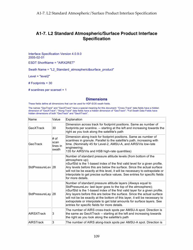
A1-7. L2 Standard Atmospheric/Surface Product Interface Specification
109
A1-7. L2 Standard Atmospheric/Surface Product Interface Specification
Interface Specification Version 4.0.9.0 2005-02-01
ESDT ShortName = "AIRX2RET"
Swath Name = "L2_Standard_atmospheric&surface_product"
Level = "level2"
# Footprints = 30
# scanlines per scanset = 1
Dimensions These fields define all dimensions that can be used for HDF-EOS swath fields.
The names "GeoTrack" and "GeoXTrack" have a special meaning for this document: "Cross-Track" data fields have a hidden dimension of "GeoXTrack"; "Along-Track" data fields have a hidden dimension of "GeoTrack"; "Full Swath Data Fields have hidden dimensions of both "GeoTrack" and "GeoXTrack".
Name Value Explanation
GeoXTrack 30 Dimension across track for footprint positions. Same as number of footprints per scanline. -- starting at the left and increasing towards the right as you look along the satellite's path
GeoTrack
# of scan lines in swath
Dimension along track for footprint positions. Same as number of scanlines in granule. Parallel to the satellite's path, increasing with time. (Nominally 45 for Level-2, AMSU-A, and AIRS/Vis low-rate engineering; 135 for AIRS/Vis and HSB high-rate quantities)
StdPressureLev 28
Number of standard pressure altitude levels (from bottom of the atmosphere up); nSurfStd is the 1-based index of the first valid level for a given profile. Any levels before this are below the surface. Since the actual surface will not be be exactly at this level, it will be necessary to extrapolate or interpolate to get precise surface values. See entries for specific fields for more details.
StdPressureLay 28
Number of standard pressure altitude layers (Always equal to StdPressureLev: last layer goes to the top of the atmosphere); nSurfStd is the 1-based index of the first valid layer for a given profile. Any layers before this are below the surface. Since the actual surface will not be be exactly at the bottom of this layer, it will be necessary to extrapolate or interpolate to get total amounts for surface layers. See entries for specific fields for more details.
AIRSXTrack 3 The number of AIRS cross-track spots per AMSU-A spot. Direction is the same as GeoXTrack -- starting at the left and increasing towards the right as you look along the satellite's path
AIRSTrack 3 The number of AIRS along-track spots per AMSU-A spot. Direction is

A1-7. L2 Standard Atmospheric/Surface Product Interface Specification
110
the same as GeoTrack -- parallel to the satellite's path, increasing with time
Cloud 2 Cloud layer dimension in order of increasing pressure. Only first numCloud elements are valid
ChanAMSUA 15
Dimension of AMSU-A Channel array (Channel 1: 23.8 GHz; Ch 2: 31.4 GHz; Ch 3: 50.3 GHz; Ch 4: 52.8 GHz; Ch 5: 53.596 +/- 0.115 GHz; Ch 6: 54.4 GHz; Ch 7: 54.94 GHz; Ch 8: 55.5 GHz; Ch 9: f0; Ch 10: f0 +/- 0.217 GHz Ch 11: f0 +/- df +/- 48 MHz; Ch 12: f0 +/- df +/- 22 MHz; Ch 13: f0 +/- df +/- 10 MHz; Ch 14: f0 +/- df +/- 4.5 MHz; Ch 15: 89 GHz (f0 = 57290.344 MHz; df = 322.4 MHz))
ChanHSB 5
Dimension of HSB Channel array (Channel 1: Deleted 89.0 GHz channel: always invalid; Ch 2: 150.0 GHz; Ch 3: f0 +/- 1.0 GHz; Ch 4: f0 +/- 3.0 GHz; Ch 5: f0 +/- 7.0 GHz (f0 = 183.31 GHz))
MWHingeSurf 7
Number of standard frequency hinge points in Microwave surface emissivity and surface brightness. Frequencies are 23.8, 31.4, 50.3, 52.8, 89.0, 150.0, 183.31 GHz respectively.Values are also found in field MWHingeSurfFreqGHz.
HingeSurf 100 Maximum number of frequency hinge points in IR surface emissivity
Geolocation Fields These fields appear for every footprint (GeoTrack * GeoXTrack times) and correspond to footprint center coordinates and "shutter" time.
Name Explanation Latitude Footprint boresight geodetic Latitude in degrees North (-90.0 ... 90.0) Longitude Footprint boresight geodetic Longitude in degrees East (-180.0 ... 180.0) Time Footprint "shutter" TAI Time: floating-point elapsed seconds since Jan 1, 1993 Size: 32400 bytes (0.0 MB) per 45-scanset granule
Attributes These fields appear only once per granule and use the HDF-EOS "Attribute" interface
Name Type Explanation
processing_level string of 8-bit characters
Zero-terminated character string denoting processing level ("level2")
instrument string of 8-bit characters
Zero-terminated character string denoting instrument ("AIRS")
DayNightFlag string of 8- Zero-terminated character string set to "Night" when the
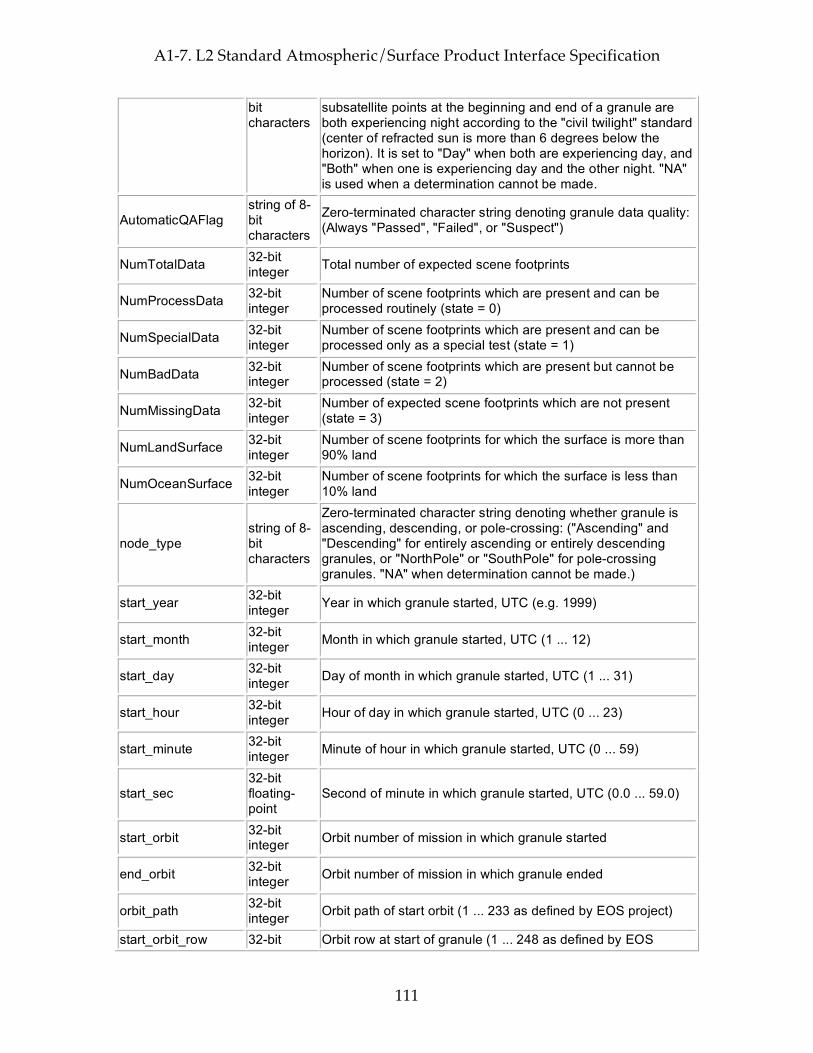
A1-7. L2 Standard Atmospheric/Surface Product Interface Specification
111
bit characters
subsatellite points at the beginning and end of a granule are both experiencing night according to the "civil twilight" standard (center of refracted sun is more than 6 degrees below the horizon). It is set to "Day" when both are experiencing day, and "Both" when one is experiencing day and the other night. "NA" is used when a determination cannot be made.
AutomaticQAFlag string of 8-bit characters
Zero-terminated character string denoting granule data quality: (Always "Passed", "Failed", or "Suspect")
NumTotalData 32-bit integer Total number of expected scene footprints
NumProcessData 32-bit integer
Number of scene footprints which are present and can be processed routinely (state = 0)
NumSpecialData 32-bit integer
Number of scene footprints which are present and can be processed only as a special test (state = 1)
NumBadData 32-bit integer
Number of scene footprints which are present but cannot be processed (state = 2)
NumMissingData 32-bit integer
Number of expected scene footprints which are not present (state = 3)
NumLandSurface 32-bit integer
Number of scene footprints for which the surface is more than 90% land
NumOceanSurface 32-bit integer
Number of scene footprints for which the surface is less than 10% land
node_type string of 8-bit characters
Zero-terminated character string denoting whether granule is ascending, descending, or pole-crossing: ("Ascending" and "Descending" for entirely ascending or entirely descending granules, or "NorthPole" or "SouthPole" for pole-crossing granules. "NA" when determination cannot be made.)
start_year 32-bit integer Year in which granule started, UTC (e.g. 1999)
start_month 32-bit integer Month in which granule started, UTC (1 ... 12)
start_day 32-bit integer Day of month in which granule started, UTC (1 ... 31)
start_hour 32-bit integer Hour of day in which granule started, UTC (0 ... 23)
start_minute 32-bit integer Minute of hour in which granule started, UTC (0 ... 59)
start_sec 32-bit floating-point
Second of minute in which granule started, UTC (0.0 ... 59.0)
start_orbit 32-bit integer Orbit number of mission in which granule started
end_orbit 32-bit integer Orbit number of mission in which granule ended
orbit_path 32-bit integer Orbit path of start orbit (1 ... 233 as defined by EOS project)
start_orbit_row 32-bit Orbit row at start of granule (1 ... 248 as defined by EOS
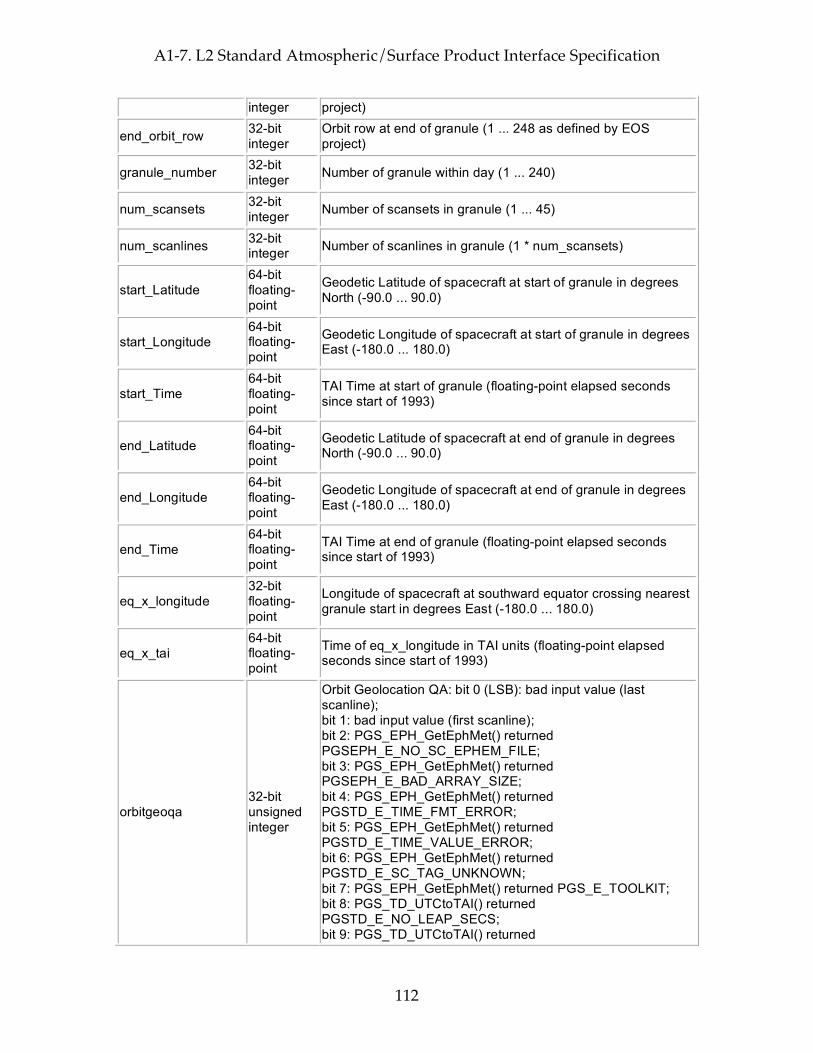
A1-7. L2 Standard Atmospheric/Surface Product Interface Specification
112
integer project)
end_orbit_row 32-bit integer
Orbit row at end of granule (1 ... 248 as defined by EOS project)
granule_number 32-bit integer Number of granule within day (1 ... 240)
num_scansets 32-bit integer Number of scansets in granule (1 ... 45)
num_scanlines 32-bit integer Number of scanlines in granule (1 * num_scansets)
start_Latitude 64-bit floating-point
Geodetic Latitude of spacecraft at start of granule in degrees North (-90.0 ... 90.0)
start_Longitude 64-bit floating-point
Geodetic Longitude of spacecraft at start of granule in degrees East (-180.0 ... 180.0)
start_Time 64-bit floating-point
TAI Time at start of granule (floating-point elapsed seconds since start of 1993)
end_Latitude 64-bit floating-point
Geodetic Latitude of spacecraft at end of granule in degrees North (-90.0 ... 90.0)
end_Longitude 64-bit floating-point
Geodetic Longitude of spacecraft at end of granule in degrees East (-180.0 ... 180.0)
end_Time 64-bit floating-point
TAI Time at end of granule (floating-point elapsed seconds since start of 1993)
eq_x_longitude 32-bit floating-point
Longitude of spacecraft at southward equator crossing nearest granule start in degrees East (-180.0 ... 180.0)
eq_x_tai 64-bit floating-point
Time of eq_x_longitude in TAI units (floating-point elapsed seconds since start of 1993)
orbitgeoqa 32-bit unsigned integer
Orbit Geolocation QA: bit 0 (LSB): bad input value (last scanline); bit 1: bad input value (first scanline); bit 2: PGS_EPH_GetEphMet() returned PGSEPH_E_NO_SC_EPHEM_FILE; bit 3: PGS_EPH_GetEphMet() returned PGSEPH_E_BAD_ARRAY_SIZE; bit 4: PGS_EPH_GetEphMet() returned PGSTD_E_TIME_FMT_ERROR; bit 5: PGS_EPH_GetEphMet() returned PGSTD_E_TIME_VALUE_ERROR; bit 6: PGS_EPH_GetEphMet() returned PGSTD_E_SC_TAG_UNKNOWN; bit 7: PGS_EPH_GetEphMet() returned PGS_E_TOOLKIT; bit 8: PGS_TD_UTCtoTAI() returned PGSTD_E_NO_LEAP_SECS; bit 9: PGS_TD_UTCtoTAI() returned

A1-7. L2 Standard Atmospheric/Surface Product Interface Specification
113
PGSTD_E_TIME_FMT_ERROR; bit 10: PGS_TD_UTCtoTAI() returned PGSTD_E_TIME_VALUE_ERROR; bit 11: PGS_TD_UTCtoTAI() returned PGS_E_TOOLKIT; bit 12: PGS_CSC_DayNight() returned PGSTD_E_NO_LEAP_SECS; bit 13: PGS_CSC_DayNight() returned PGSCSC_E_INVALID_LIMITTAG; bit 14: PGS_CSC_DayNight() returned PGSCSC_E_BAD_ARRAY_SIZE; bit 15: PGS_CSC_DayNight() returned PGSCSC_W_ERROR_IN_DAYNIGHT; bit 16: PGS_CSC_DayNight() returned PGSCSC_W_BAD_TRANSFORM_VALUE; bit 17: PGS_CSC_DayNight() returned PGSCSC_W_BELOW_HORIZON; bit 18: PGS_CSC_DayNight() returned PGSCSC_W_PREDICTED_UT1; bit 19: PGS_CSC_DayNight() returned PGSTD_E_NO_UT1_VALUE; bit 20: PGS_CSC_DayNight() returned PGSTD_E_BAD_INITIAL_TIME; bit 21: PGS_CSC_DayNight() returned PGSCBP_E_TIME_OUT_OF_RANGE; bit 22: PGS_CSC_DayNight() returned PGSCBP_E_UNABLE_TO_OPEN_FILE; bit 22: PGS_CSC_DayNight() returned PGSMEM_E_NO_MEMORY; bit 24: PGS_CSC_DayNight() returned PGS_E_TOOLKIT; bit 25-31: not used
num_satgeoqa 16-bit integer Number of scans with problems in satgeoqa
num_glintgeoqa 16-bit integer Number of scans with problems in glintgeoqa
num_moongeoqa 16-bit integer Number of scans with problems in moongeoqa
num_ftptgeoqa 16-bit integer Number of footprints with problems in ftptgeoqa
num_zengeoqa 16-bit integer Number of footprints with problems in zengeoqa
num_demgeoqa 16-bit integer Number of footprints with problems in demgeoqa
num_fpe 16-bit integer Number of floating point errors
LonGranuleCen 16-bit integer
Geodetic Longitude of the center of the granule in degrees East (-180 ... 180)
LatGranuleCen 16-bit integer
Geodetic Latitude of the center of the granule in degrees North (-90 ... 90)
LocTimeGranuleCen 16-bit integer
Local solar time at the center of the granule in minutes past midnight (0 ... 1439)
granules_present string of 8- Zero-terminated character string denoting which adjacent

A1-7. L2 Standard Atmospheric/Surface Product Interface Specification
114
bit characters
granules were available for precipitation ("All" for both previous & next, "Prev" for previous but not next, "Next" for next but not previous, "None" for neither previous nor next)
Size: 174 bytes (0.0 MB) per granule
Per-Granule Data Fields These fields appear only once per granule and use the HDF-EOS "Field" interface
Name Type Extra Dimensions Explanation
pressStd 32-bit floating-point
StdPressureLev (= 28)
Standard pressures in mbar (bottom of the atmosphere first)
MWHingeSurfFreqGHz 32-bit floating-point
MWHingeSurf (= 7)
Frequencies in GHz for MW surface parameters (SfcTbMWStd, EmisMWStd,...)
Size: 140 bytes (0.0 MB) per granule
Along-Track Data Fields These fields appear once per scanline (GeoTrack times)
Name Type Extra Dimensions Explanation
satheight 32-bit floating-point
None Satellite altitude at nadirTAI in km above reference ellipsoid (e.g. 725.2)
satroll 32-bit floating-point
None
Satellite attitude roll angle at nadirTAI (-180.0 ... 180.0 angle about the +x (roll) ORB axis, +x axis is positively oriented in the direction of orbital flight completing an orthogonal triad with y and z.)
satpitch 32-bit floating-point
None
Satellite attitude pitch angle at nadirTAI (-180.0 ... 180.0 angle about +y (pitch) ORB axis. +y axis is oriented normal to the orbit plane with the positive sense opposite to that of the orbit's angular momentum vector H.)
satyaw 32-bit floating-point
None
Satellite attitude yaw angle at nadirTAI (-180.0 ... 180.0 angle about +z (yaw) axis. +z axis is positively oriented Earthward parallel to the satellite radius vector R from the spacecraft center of mass to the center of the Earth.)
satgeoqa 32-bit unsigned integer
None
Satellite Geolocation QA flags: bit 0 (LSB): bad input value; bit 1: PGS_TD_TAItoUTC() returned PGSTD_E_NO_LEAP_SECS; bit 2: PGS_TD_TAItoUTC() returned PGS_E_TOOLKIT; bit 3: PGS_EPH_EphemAttit() returned PGSEPH_W_BAD_EPHEM_VALUE; bit 4: PGS_EPH_EphemAttit() returned PGSEPH_E_BAD_EPHEM_FILE_HDR; bit 5: PGS_EPH_EphemAttit() returned PGSEPH_E_NO_SC_EPHEM_FILE; bit 6: PGS_EPH_EphemAttit() returned PGSEPH_E_NO_DATA_REQUESTED;
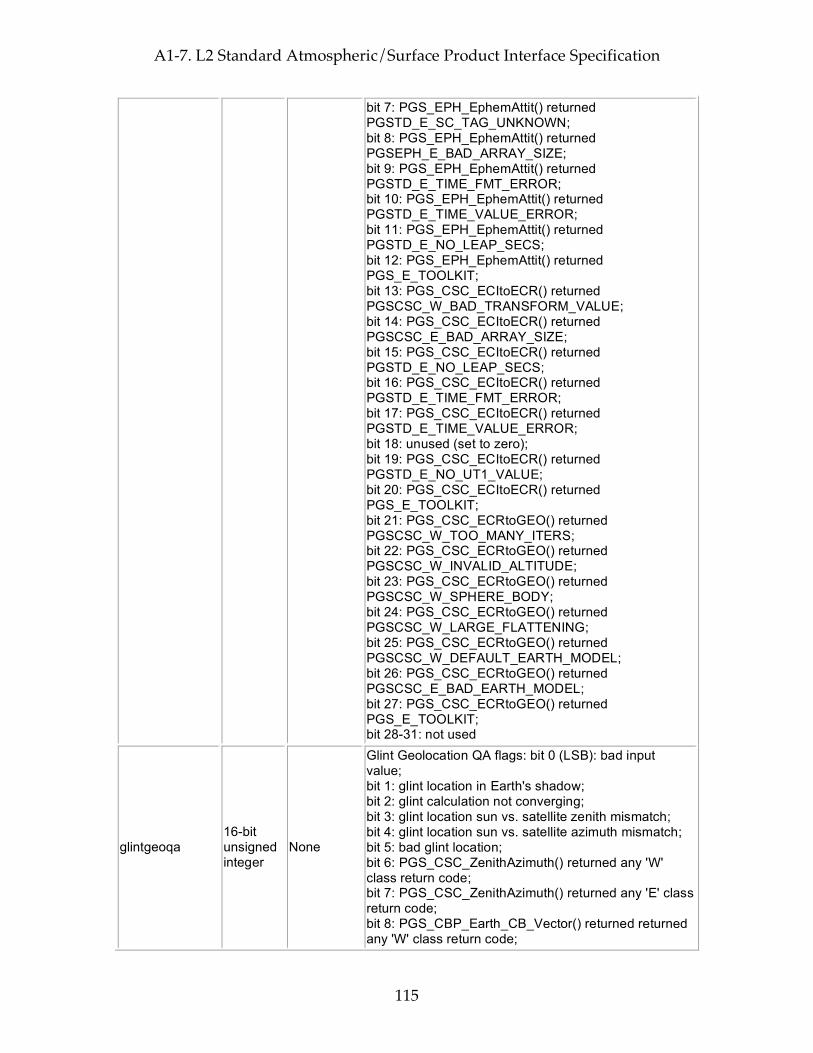
A1-7. L2 Standard Atmospheric/Surface Product Interface Specification
115
bit 7: PGS_EPH_EphemAttit() returned PGSTD_E_SC_TAG_UNKNOWN; bit 8: PGS_EPH_EphemAttit() returned PGSEPH_E_BAD_ARRAY_SIZE; bit 9: PGS_EPH_EphemAttit() returned PGSTD_E_TIME_FMT_ERROR; bit 10: PGS_EPH_EphemAttit() returned PGSTD_E_TIME_VALUE_ERROR; bit 11: PGS_EPH_EphemAttit() returned PGSTD_E_NO_LEAP_SECS; bit 12: PGS_EPH_EphemAttit() returned PGS_E_TOOLKIT; bit 13: PGS_CSC_ECItoECR() returned PGSCSC_W_BAD_TRANSFORM_VALUE; bit 14: PGS_CSC_ECItoECR() returned PGSCSC_E_BAD_ARRAY_SIZE; bit 15: PGS_CSC_ECItoECR() returned PGSTD_E_NO_LEAP_SECS; bit 16: PGS_CSC_ECItoECR() returned PGSTD_E_TIME_FMT_ERROR; bit 17: PGS_CSC_ECItoECR() returned PGSTD_E_TIME_VALUE_ERROR; bit 18: unused (set to zero); bit 19: PGS_CSC_ECItoECR() returned PGSTD_E_NO_UT1_VALUE; bit 20: PGS_CSC_ECItoECR() returned PGS_E_TOOLKIT; bit 21: PGS_CSC_ECRtoGEO() returned PGSCSC_W_TOO_MANY_ITERS; bit 22: PGS_CSC_ECRtoGEO() returned PGSCSC_W_INVALID_ALTITUDE; bit 23: PGS_CSC_ECRtoGEO() returned PGSCSC_W_SPHERE_BODY; bit 24: PGS_CSC_ECRtoGEO() returned PGSCSC_W_LARGE_FLATTENING; bit 25: PGS_CSC_ECRtoGEO() returned PGSCSC_W_DEFAULT_EARTH_MODEL; bit 26: PGS_CSC_ECRtoGEO() returned PGSCSC_E_BAD_EARTH_MODEL; bit 27: PGS_CSC_ECRtoGEO() returned PGS_E_TOOLKIT; bit 28-31: not used
glintgeoqa 16-bit unsigned integer
None
Glint Geolocation QA flags: bit 0 (LSB): bad input value; bit 1: glint location in Earth's shadow; bit 2: glint calculation not converging; bit 3: glint location sun vs. satellite zenith mismatch; bit 4: glint location sun vs. satellite azimuth mismatch; bit 5: bad glint location; bit 6: PGS_CSC_ZenithAzimuth() returned any 'W' class return code; bit 7: PGS_CSC_ZenithAzimuth() returned any 'E' class return code; bit 8: PGS_CBP_Earth_CB_Vector() returned returned any 'W' class return code;

A1-7. L2 Standard Atmospheric/Surface Product Interface Specification
116
bit 9: PGS_CBP_Earth_CB_Vector() returned returned any 'E' class return code; bit 10: PGS_CSC_ECItoECR() returned any 'W' class return code except PGSCSC_W_PREDICTED_UT1 (for Glint); bit 11: PGS_CSC_ECItoECR() returned any 'E' class return code (for Glint); bit 12: PGS_CSC_ECRtoGEO() returned any 'W' class return code (for Glint); bit 13: PGS_CSC_ECRtoGEO() returned any 'E' class return code (for Glint); bit 14: PGS_CSC_ECItoECR() returned any 'W' class return code except PGSCSC_W_PREDICTED_UT1 ; bit 15: PGS_CSC_ECItoECR() returned any 'E' class return code
moongeoqa 16-bit unsigned integer
None
Moon Geolocation QA flags: bit 0 (LSB): bad input value; bit 1: PGS_TD_TAItoUTC() returned PGSTD_E_NO_LEAP_SECS; bit 2: PGS_TD_TAItoUTC() returned PGS_E_TOOLKIT; bit 3: PGS_CBP_Sat_CB_Vector() returned PGSCSC_W_BELOW_SURFACE; bit 4: PGS_CBP_Sat_CB_Vector() returned PGSCBP_W_BAD_CB_VECTOR; bit 5: PGS_CBP_Sat_CB_Vector() returned PGSCBP_E_BAD_ARRAY_SIZE; bit 6: PGS_CBP_Sat_CB_Vector() returned PGSCBP_E_INVALID_CB_ID; bit 7: PGS_CBP_Sat_CB_Vector() returned PGSMEM_E_NO_MEMORY; bit 8: PGS_CBP_Sat_CB_Vector() returned PGSCBP_E_UNABLE_TO_OPEN_FILE; bit 9: PGS_CBP_Sat_CB_Vector() returned PGSTD_E_BAD_INITIAL_TIME; bit 10: PGS_CBP_Sat_CB_Vector() returned PGSCBP_E_TIME_OUT_OF_RANGE; bit 11: PGS_CBP_Sat_CB_Vector() returned PGSTD_E_SC_TAG_UNKNOWN; bit 12: PGS_CBP_Sat_CB_Vector() returned PGSEPH_E_BAD_EPHEM_FILE_HDR; bit 13: PGS_CBP_Sat_CB_Vector() returned PGSEPH_E_NO_SC_EPHEM_FILE; bit 14: PGS_CBP_Sat_CB_Vector() returned PGS_E_TOOLKIT; bit 15: not used
nadirTAI 64-bit floating-point
None
TAI time at which instrument is nominally looking directly down. (between footprints 15 & 16 for AMSU or between footprints 45 & 46 for AIRS/Vis & HSB) (floating-point elapsed seconds since start of 1993)
sat_lat 64-bit floating-point
None Satellite geodetic latitude in degrees North (-90.0 ... 90.0)
sat_lon 64-bit None Satellite geodetic longitude in degrees East (-180.0 ...
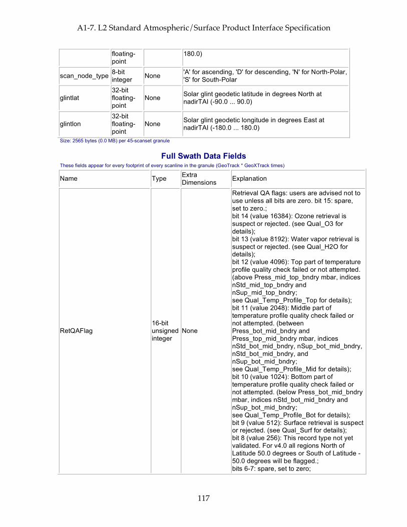
A1-7. L2 Standard Atmospheric/Surface Product Interface Specification
117
floating-point
180.0)
scan_node_type 8-bit integer None 'A' for ascending, 'D' for descending, 'N' for North-Polar,
'S' for South-Polar
glintlat 32-bit floating-point
None Solar glint geodetic latitude in degrees North at nadirTAI (-90.0 ... 90.0)
glintlon 32-bit floating-point
None Solar glint geodetic longitude in degrees East at nadirTAI (-180.0 ... 180.0)
Size: 2565 bytes (0.0 MB) per 45-scanset granule
Full Swath Data Fields These fields appear for every footprint of every scanline in the granule (GeoTrack * GeoXTrack times)
Name Type Extra Dimensions Explanation
RetQAFlag 16-bit unsigned integer
None
Retrieval QA flags: users are advised not to use unless all bits are zero. bit 15: spare, set to zero.; bit 14 (value 16384): Ozone retrieval is suspect or rejected. (see Qual_O3 for details); bit 13 (value 8192): Water vapor retrieval is suspect or rejected. (see Qual_H2O for details); bit 12 (value 4096): Top part of temperature profile quality check failed or not attempted. (above Press_mid_top_bndry mbar, indices nStd_mid_top_bndry and nSup_mid_top_bndry; see Qual_Temp_Profile_Top for details); bit 11 (value 2048): Middle part of temperature profile quality check failed or not attempted. (between Press_bot_mid_bndry and Press_top_mid_bndry mbar, indices nStd_bot_mid_bndry, nSup_bot_mid_bndry, nStd_bot_mid_bndry, and nSup_bot_mid_bndry; see Qual_Temp_Profile_Mid for details); bit 10 (value 1024): Bottom part of temperature profile quality check failed or not attempted. (below Press_bot_mid_bndry mbar, indices nStd_bot_mid_bndry and nSup_bot_mid_bndry; see Qual_Temp_Profile_Bot for details); bit 9 (value 512): Surface retrieval is suspect or rejected. (see Qual_Surf for details); bit 8 (value 256): This record type not yet validated. For v4.0 all regions North of Latitude 50.0 degrees or South of Latitude -50.0 degrees will be flagged.; bits 6-7: spare, set to zero;
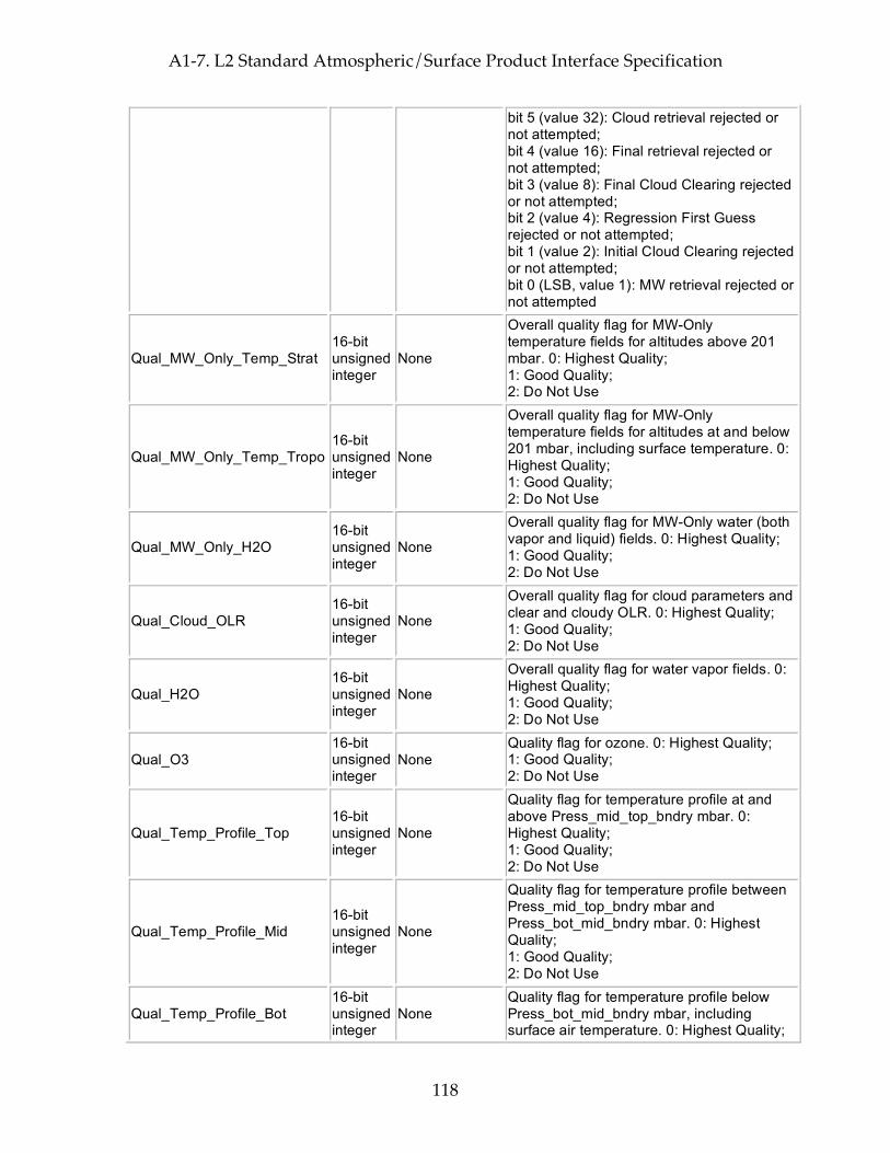
A1-7. L2 Standard Atmospheric/Surface Product Interface Specification
118
bit 5 (value 32): Cloud retrieval rejected or not attempted; bit 4 (value 16): Final retrieval rejected or not attempted; bit 3 (value 8): Final Cloud Clearing rejected or not attempted; bit 2 (value 4): Regression First Guess rejected or not attempted; bit 1 (value 2): Initial Cloud Clearing rejected or not attempted; bit 0 (LSB, value 1): MW retrieval rejected or not attempted
Qual_MW_Only_Temp_Strat 16-bit unsigned integer
None
Overall quality flag for MW-Only temperature fields for altitudes above 201 mbar. 0: Highest Quality; 1: Good Quality; 2: Do Not Use
Qual_MW_Only_Temp_Tropo 16-bit unsigned integer
None
Overall quality flag for MW-Only temperature fields for altitudes at and below 201 mbar, including surface temperature. 0: Highest Quality; 1: Good Quality; 2: Do Not Use
Qual_MW_Only_H2O 16-bit unsigned integer
None
Overall quality flag for MW-Only water (both vapor and liquid) fields. 0: Highest Quality; 1: Good Quality; 2: Do Not Use
Qual_Cloud_OLR 16-bit unsigned integer
None
Overall quality flag for cloud parameters and clear and cloudy OLR. 0: Highest Quality; 1: Good Quality; 2: Do Not Use
Qual_H2O 16-bit unsigned integer
None
Overall quality flag for water vapor fields. 0: Highest Quality; 1: Good Quality; 2: Do Not Use
Qual_O3 16-bit unsigned integer
None Quality flag for ozone. 0: Highest Quality; 1: Good Quality; 2: Do Not Use
Qual_Temp_Profile_Top 16-bit unsigned integer
None
Quality flag for temperature profile at and above Press_mid_top_bndry mbar. 0: Highest Quality; 1: Good Quality; 2: Do Not Use
Qual_Temp_Profile_Mid 16-bit unsigned integer
None
Quality flag for temperature profile between Press_mid_top_bndry mbar and Press_bot_mid_bndry mbar. 0: Highest Quality; 1: Good Quality; 2: Do Not Use
Qual_Temp_Profile_Bot 16-bit unsigned integer
None Quality flag for temperature profile below Press_bot_mid_bndry mbar, including surface air temperature. 0: Highest Quality;
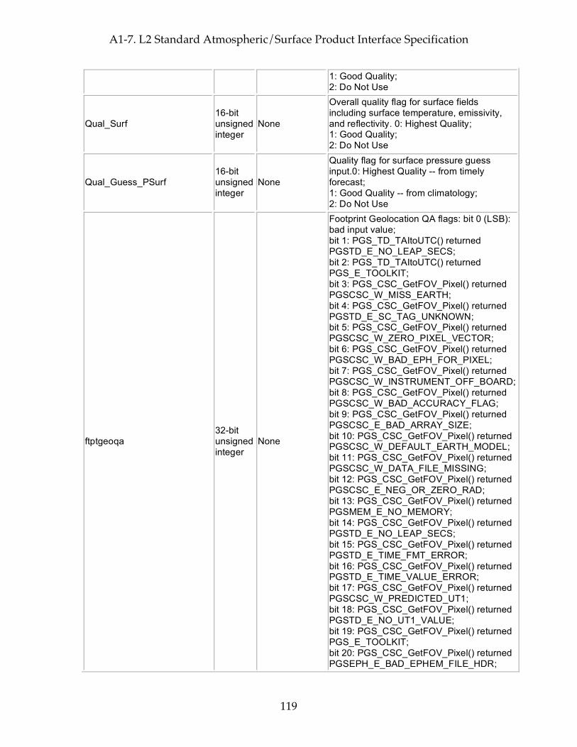
A1-7. L2 Standard Atmospheric/Surface Product Interface Specification
119
1: Good Quality; 2: Do Not Use
Qual_Surf 16-bit unsigned integer
None
Overall quality flag for surface fields including surface temperature, emissivity, and reflectivity. 0: Highest Quality; 1: Good Quality; 2: Do Not Use
Qual_Guess_PSurf 16-bit unsigned integer
None
Quality flag for surface pressure guess input.0: Highest Quality -- from timely forecast; 1: Good Quality -- from climatology; 2: Do Not Use
ftptgeoqa 32-bit unsigned integer
None
Footprint Geolocation QA flags: bit 0 (LSB): bad input value; bit 1: PGS_TD_TAItoUTC() returned PGSTD_E_NO_LEAP_SECS; bit 2: PGS_TD_TAItoUTC() returned PGS_E_TOOLKIT; bit 3: PGS_CSC_GetFOV_Pixel() returned PGSCSC_W_MISS_EARTH; bit 4: PGS_CSC_GetFOV_Pixel() returned PGSTD_E_SC_TAG_UNKNOWN; bit 5: PGS_CSC_GetFOV_Pixel() returned PGSCSC_W_ZERO_PIXEL_VECTOR; bit 6: PGS_CSC_GetFOV_Pixel() returned PGSCSC_W_BAD_EPH_FOR_PIXEL; bit 7: PGS_CSC_GetFOV_Pixel() returned PGSCSC_W_INSTRUMENT_OFF_BOARD; bit 8: PGS_CSC_GetFOV_Pixel() returned PGSCSC_W_BAD_ACCURACY_FLAG; bit 9: PGS_CSC_GetFOV_Pixel() returned PGSCSC_E_BAD_ARRAY_SIZE; bit 10: PGS_CSC_GetFOV_Pixel() returned PGSCSC_W_DEFAULT_EARTH_MODEL; bit 11: PGS_CSC_GetFOV_Pixel() returned PGSCSC_W_DATA_FILE_MISSING; bit 12: PGS_CSC_GetFOV_Pixel() returned PGSCSC_E_NEG_OR_ZERO_RAD; bit 13: PGS_CSC_GetFOV_Pixel() returned PGSMEM_E_NO_MEMORY; bit 14: PGS_CSC_GetFOV_Pixel() returned PGSTD_E_NO_LEAP_SECS; bit 15: PGS_CSC_GetFOV_Pixel() returned PGSTD_E_TIME_FMT_ERROR; bit 16: PGS_CSC_GetFOV_Pixel() returned PGSTD_E_TIME_VALUE_ERROR; bit 17: PGS_CSC_GetFOV_Pixel() returned PGSCSC_W_PREDICTED_UT1; bit 18: PGS_CSC_GetFOV_Pixel() returned PGSTD_E_NO_UT1_VALUE; bit 19: PGS_CSC_GetFOV_Pixel() returned PGS_E_TOOLKIT; bit 20: PGS_CSC_GetFOV_Pixel() returned PGSEPH_E_BAD_EPHEM_FILE_HDR;
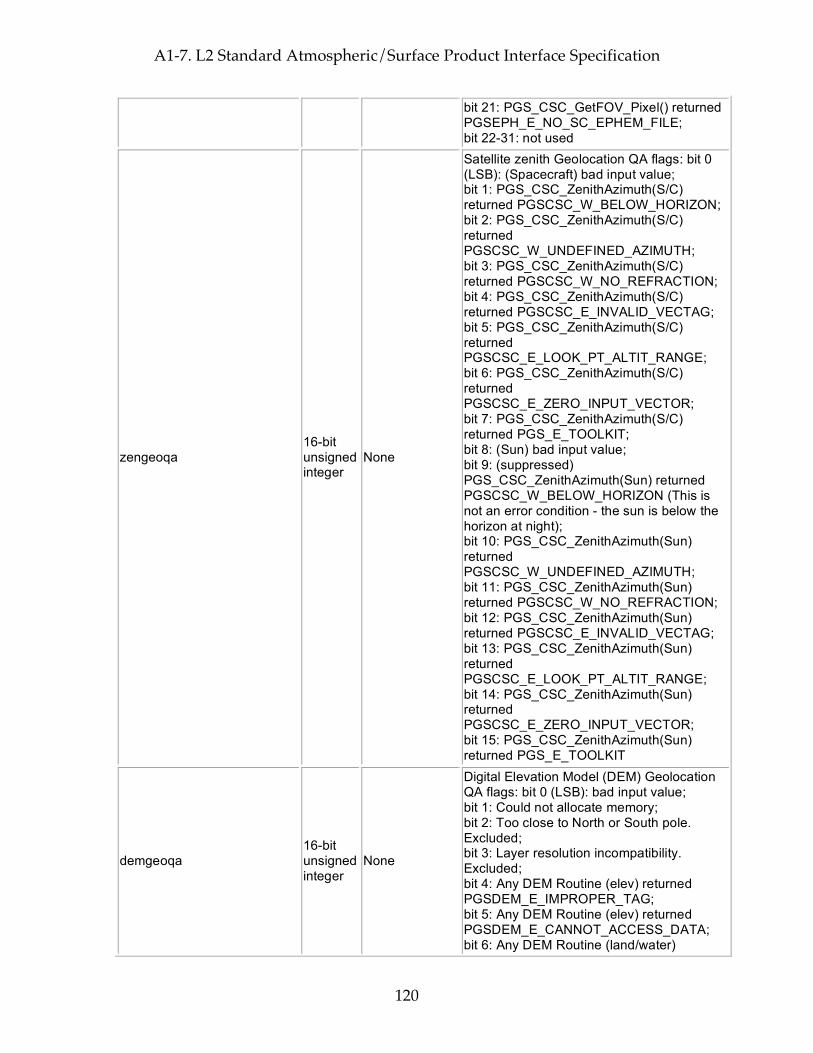
A1-7. L2 Standard Atmospheric/Surface Product Interface Specification
120
bit 21: PGS_CSC_GetFOV_Pixel() returned PGSEPH_E_NO_SC_EPHEM_FILE; bit 22-31: not used
zengeoqa 16-bit unsigned integer
None
Satellite zenith Geolocation QA flags: bit 0 (LSB): (Spacecraft) bad input value; bit 1: PGS_CSC_ZenithAzimuth(S/C) returned PGSCSC_W_BELOW_HORIZON; bit 2: PGS_CSC_ZenithAzimuth(S/C) returned PGSCSC_W_UNDEFINED_AZIMUTH; bit 3: PGS_CSC_ZenithAzimuth(S/C) returned PGSCSC_W_NO_REFRACTION; bit 4: PGS_CSC_ZenithAzimuth(S/C) returned PGSCSC_E_INVALID_VECTAG; bit 5: PGS_CSC_ZenithAzimuth(S/C) returned PGSCSC_E_LOOK_PT_ALTIT_RANGE; bit 6: PGS_CSC_ZenithAzimuth(S/C) returned PGSCSC_E_ZERO_INPUT_VECTOR; bit 7: PGS_CSC_ZenithAzimuth(S/C) returned PGS_E_TOOLKIT; bit 8: (Sun) bad input value; bit 9: (suppressed) PGS_CSC_ZenithAzimuth(Sun) returned PGSCSC_W_BELOW_HORIZON (This is not an error condition - the sun is below the horizon at night); bit 10: PGS_CSC_ZenithAzimuth(Sun) returned PGSCSC_W_UNDEFINED_AZIMUTH; bit 11: PGS_CSC_ZenithAzimuth(Sun) returned PGSCSC_W_NO_REFRACTION; bit 12: PGS_CSC_ZenithAzimuth(Sun) returned PGSCSC_E_INVALID_VECTAG; bit 13: PGS_CSC_ZenithAzimuth(Sun) returned PGSCSC_E_LOOK_PT_ALTIT_RANGE; bit 14: PGS_CSC_ZenithAzimuth(Sun) returned PGSCSC_E_ZERO_INPUT_VECTOR; bit 15: PGS_CSC_ZenithAzimuth(Sun) returned PGS_E_TOOLKIT
demgeoqa 16-bit unsigned integer
None
Digital Elevation Model (DEM) Geolocation QA flags: bit 0 (LSB): bad input value; bit 1: Could not allocate memory; bit 2: Too close to North or South pole. Excluded; bit 3: Layer resolution incompatibility. Excluded; bit 4: Any DEM Routine (elev) returned PGSDEM_E_IMPROPER_TAG; bit 5: Any DEM Routine (elev) returned PGSDEM_E_CANNOT_ACCESS_DATA; bit 6: Any DEM Routine (land/water)

A1-7. L2 Standard Atmospheric/Surface Product Interface Specification
121
returned PGSDEM_E_IMPROPER_TAG; bit 7: Any DEM Routine (land/water) returned PGSDEM_E_CANNOT_ACCESS_DATA; bit 8: Reserved for future layers; bit 9: Reserved for future layers; bit 10: PGS_DEM_GetRegion(elev) returned PGSDEM_M_FILLVALUE_INCLUDED; bit 11: PGS_DEM_GetRegion(land/water) returned PGSDEM_M_FILLVALUE_INCLUDED; bit 12: Reserved for future layers; bit 13: PGS_DEM_GetRegion(all) returned PGSDEM_M_MULTIPLE_RESOLUTIONS; bit 14: PGS_CSC_GetFOV_Pixel() returned any 'W' class return code except PGSCSC_W_PREDICTED_UT1; bit 15: PGS_CSC_GetFOV_Pixel() returned any 'E' class return code
satzen 32-bit floating-point
None
Spacecraft zenith angle (0.0 ... 180.0) degrees from zenith (measured relative to the geodetic vertical on the reference (WGS84) spheroid and including corrections outlined in EOS SDP toolkit for normal accuracy.)
satazi 32-bit floating-point
None Spacecraft azimuth angle (-180.0 ... 180.0) degrees E of N GEO)
solzen 32-bit floating-point
None
Solar zenith angle (0.0 ... 180.0) degrees from zenith (measured relative to the geodetic vertical on the reference (WGS84) spheroid and including corrections outlined in EOS SDP toolkit for normal accuracy.)
solazi 32-bit floating-point
None Solar azimuth angle (-180.0 ... 180.0) degrees E of N GEO)
sun_glint_distance 16-bit integer None
Distance (km) from footprint center to location of the sun glint (-9999 for unknown, 30000 for no glint visible because spacecraft is in Earth's shadow)
topog 32-bit floating-point
None Mean topography in meters above reference ellipsoid
topog_err 32-bit floating-point
None Error estimate for topog
landFrac 32-bit floating-point
None Fraction of spot that is land (0.0 ... 1.0)
landFrac_err 32-bit floating-point
None Error estimate for landFrac
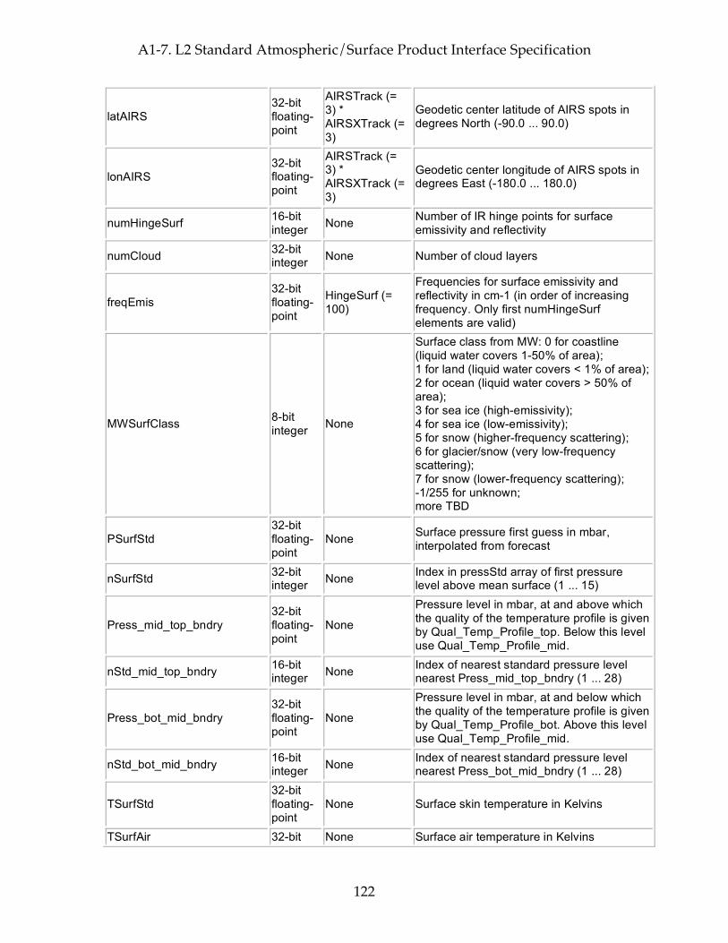
A1-7. L2 Standard Atmospheric/Surface Product Interface Specification
122
latAIRS 32-bit floating-point
AIRSTrack (= 3) * AIRSXTrack (= 3)
Geodetic center latitude of AIRS spots in degrees North (-90.0 ... 90.0)
lonAIRS 32-bit floating-point
AIRSTrack (= 3) * AIRSXTrack (= 3)
Geodetic center longitude of AIRS spots in degrees East (-180.0 ... 180.0)
numHingeSurf 16-bit integer None Number of IR hinge points for surface
emissivity and reflectivity
numCloud 32-bit integer None Number of cloud layers
freqEmis 32-bit floating-point
HingeSurf (= 100)
Frequencies for surface emissivity and reflectivity in cm-1 (in order of increasing frequency. Only first numHingeSurf elements are valid)
MWSurfClass 8-bit integer None
Surface class from MW: 0 for coastline (liquid water covers 1-50% of area); 1 for land (liquid water covers < 1% of area); 2 for ocean (liquid water covers > 50% of area); 3 for sea ice (high-emissivity); 4 for sea ice (low-emissivity); 5 for snow (higher-frequency scattering); 6 for glacier/snow (very low-frequency scattering); 7 for snow (lower-frequency scattering); -1/255 for unknown; more TBD
PSurfStd 32-bit floating-point
None Surface pressure first guess in mbar, interpolated from forecast
nSurfStd 32-bit integer None Index in pressStd array of first pressure
level above mean surface (1 ... 15)
Press_mid_top_bndry 32-bit floating-point
None
Pressure level in mbar, at and above which the quality of the temperature profile is given by Qual_Temp_Profile_top. Below this level use Qual_Temp_Profile_mid.
nStd_mid_top_bndry 16-bit integer None Index of nearest standard pressure level
nearest Press_mid_top_bndry (1 ... 28)
Press_bot_mid_bndry 32-bit floating-point
None
Pressure level in mbar, at and below which the quality of the temperature profile is given by Qual_Temp_Profile_bot. Above this level use Qual_Temp_Profile_mid.
nStd_bot_mid_bndry 16-bit integer None Index of nearest standard pressure level
nearest Press_bot_mid_bndry (1 ... 28)
TSurfStd 32-bit floating-point
None Surface skin temperature in Kelvins
TSurfAir 32-bit None Surface air temperature in Kelvins
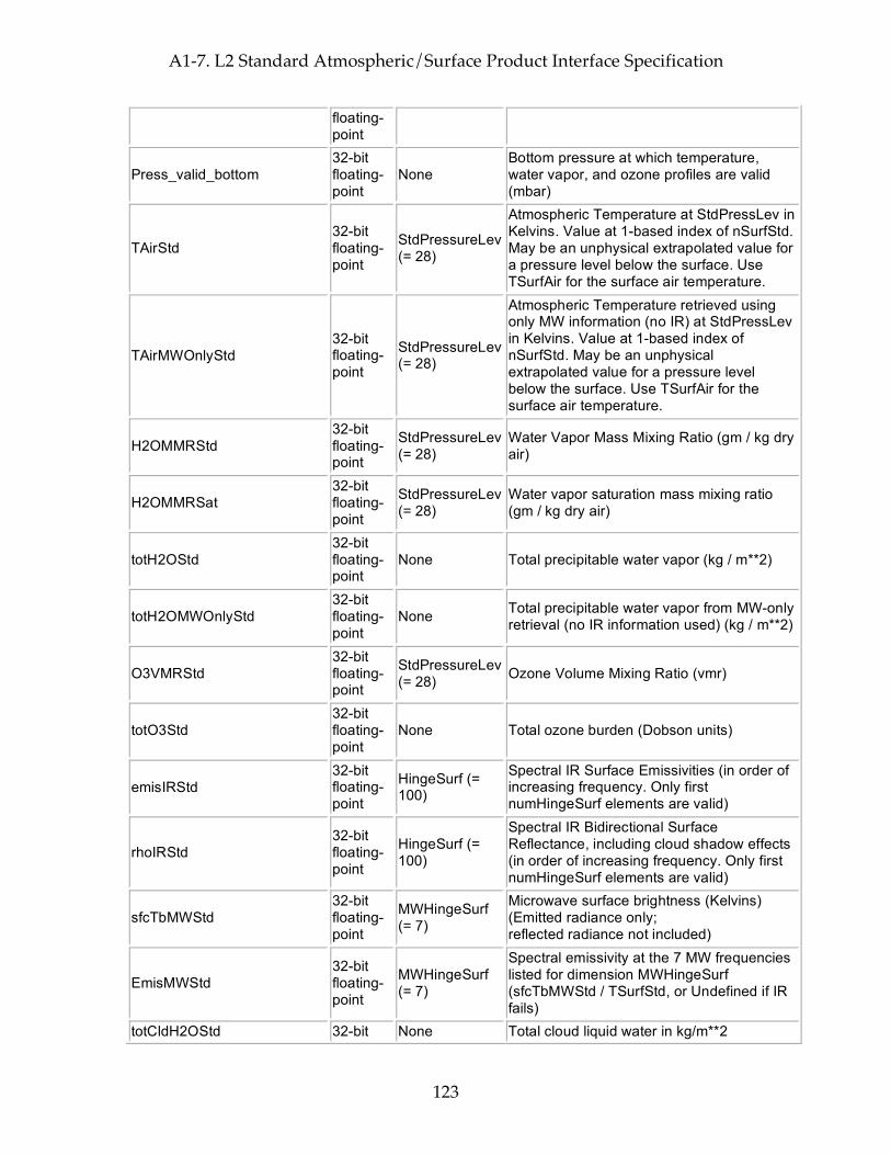
A1-7. L2 Standard Atmospheric/Surface Product Interface Specification
123
floating-point
Press_valid_bottom 32-bit floating-point
None Bottom pressure at which temperature, water vapor, and ozone profiles are valid (mbar)
TAirStd 32-bit floating-point
StdPressureLev (= 28)
Atmospheric Temperature at StdPressLev in Kelvins. Value at 1-based index of nSurfStd. May be an unphysical extrapolated value for a pressure level below the surface. Use TSurfAir for the surface air temperature.
TAirMWOnlyStd 32-bit floating-point
StdPressureLev (= 28)
Atmospheric Temperature retrieved using only MW information (no IR) at StdPressLev in Kelvins. Value at 1-based index of nSurfStd. May be an unphysical extrapolated value for a pressure level below the surface. Use TSurfAir for the surface air temperature.
H2OMMRStd 32-bit floating-point
StdPressureLev (= 28)
Water Vapor Mass Mixing Ratio (gm / kg dry air)
H2OMMRSat 32-bit floating-point
StdPressureLev (= 28)
Water vapor saturation mass mixing ratio (gm / kg dry air)
totH2OStd 32-bit floating-point
None Total precipitable water vapor (kg / m**2)
totH2OMWOnlyStd 32-bit floating-point
None Total precipitable water vapor from MW-only retrieval (no IR information used) (kg / m**2)
O3VMRStd 32-bit floating-point
StdPressureLev (= 28) Ozone Volume Mixing Ratio (vmr)
totO3Std 32-bit floating-point
None Total ozone burden (Dobson units)
emisIRStd 32-bit floating-point
HingeSurf (= 100)
Spectral IR Surface Emissivities (in order of increasing frequency. Only first numHingeSurf elements are valid)
rhoIRStd 32-bit floating-point
HingeSurf (= 100)
Spectral IR Bidirectional Surface Reflectance, including cloud shadow effects (in order of increasing frequency. Only first numHingeSurf elements are valid)
sfcTbMWStd 32-bit floating-point
MWHingeSurf (= 7)
Microwave surface brightness (Kelvins) (Emitted radiance only; reflected radiance not included)
EmisMWStd 32-bit floating-point
MWHingeSurf (= 7)
Spectral emissivity at the 7 MW frequencies listed for dimension MWHingeSurf (sfcTbMWStd / TSurfStd, or Undefined if IR fails)
totCldH2OStd 32-bit None Total cloud liquid water in kg/m**2
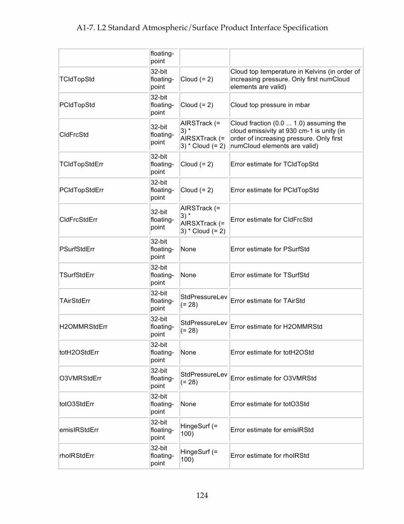
A1-7. L2 Standard Atmospheric/Surface Product Interface Specification
124
floating-point
TCldTopStd 32-bit floating-point
Cloud (= 2) Cloud top temperature in Kelvins (in order of increasing pressure. Only first numCloud elements are valid)
PCldTopStd 32-bit floating-point
Cloud (= 2) Cloud top pressure in mbar
CldFrcStd 32-bit floating-point
AIRSTrack (= 3) * AIRSXTrack (= 3) * Cloud (= 2)
Cloud fraction (0.0 ... 1.0) assuming the cloud emissivity at 930 cm-1 is unity (in order of increasing pressure. Only first numCloud elements are valid)
TCldTopStdErr 32-bit floating-point
Cloud (= 2) Error estimate for TCldTopStd
PCldTopStdErr 32-bit floating-point
Cloud (= 2) Error estimate for PCldTopStd
CldFrcStdErr 32-bit floating-point
AIRSTrack (= 3) * AIRSXTrack (= 3) * Cloud (= 2)
Error estimate for CldFrcStd
PSurfStdErr 32-bit floating-point
None Error estimate for PSurfStd
TSurfStdErr 32-bit floating-point
None Error estimate for TSurfStd
TAirStdErr 32-bit floating-point
StdPressureLev (= 28) Error estimate for TAirStd
H2OMMRStdErr 32-bit floating-point
StdPressureLev (= 28) Error estimate for H2OMMRStd
totH2OStdErr 32-bit floating-point
None Error estimate for totH2OStd
O3VMRStdErr 32-bit floating-point
StdPressureLev (= 28) Error estimate for O3VMRStd
totO3StdErr 32-bit floating-point
None Error estimate for totO3Std
emisIRStdErr 32-bit floating-point
HingeSurf (= 100) Error estimate for emisIRStd
rhoIRStdErr 32-bit floating-point
HingeSurf (= 100) Error estimate for rhoIRStd
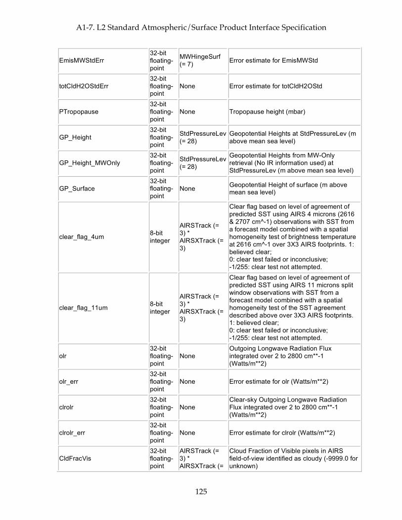
A1-7. L2 Standard Atmospheric/Surface Product Interface Specification
125
EmisMWStdErr 32-bit floating-point
MWHingeSurf (= 7) Error estimate for EmisMWStd
totCldH2OStdErr 32-bit floating-point
None Error estimate for totCldH2OStd
PTropopause 32-bit floating-point
None Tropopause height (mbar)
GP_Height 32-bit floating-point
StdPressureLev (= 28)
Geopotential Heights at StdPressureLev (m above mean sea level)
GP_Height_MWOnly 32-bit floating-point
StdPressureLev (= 28)
Geopotential Heights from MW-Only retrieval (No IR information used) at StdPressureLev (m above mean sea level)
GP_Surface 32-bit floating-point
None Geopotential Height of surface (m above mean sea level)
clear_flag_4um 8-bit integer
AIRSTrack (= 3) * AIRSXTrack (= 3)
Clear flag based on level of agreement of predicted SST using AIRS 4 microns (2616 & 2707 cm^-1) observations with SST from a forecast model combined with a spatial homogeneity test of brightness temperature at 2616 cm^-1 over 3X3 AIRS footprints. 1: believed clear; 0: clear test failed or inconclusive; -1/255: clear test not attempted.
clear_flag_11um 8-bit integer
AIRSTrack (= 3) * AIRSXTrack (= 3)
Clear flag based on level of agreement of predicted SST using AIRS 11 microns split window observations with SST from a forecast model combined with a spatial homogeneity test of the SST agreement described above over 3X3 AIRS footprints. 1: believed clear; 0: clear test failed or inconclusive; -1/255: clear test not attempted.
olr 32-bit floating-point
None Outgoing Longwave Radiation Flux integrated over 2 to 2800 cm**-1 (Watts/m**2)
olr_err 32-bit floating-point
None Error estimate for olr (Watts/m**2)
clrolr 32-bit floating-point
None Clear-sky Outgoing Longwave Radiation Flux integrated over 2 to 2800 cm**-1 (Watts/m**2)
clrolr_err 32-bit floating-point
None Error estimate for clrolr (Watts/m**2)
CldFracVis 32-bit floating-point
AIRSTrack (= 3) * AIRSXTrack (=
Cloud Fraction of Visible pixels in AIRS field-of-view identified as cloudy (-9999.0 for unknown)

A1-7. L2 Standard Atmospheric/Surface Product Interface Specification
126
3)
CldFracVisErr 32-bit floating-point
AIRSTrack (= 3) * AIRSXTrack (= 3)
Error Estimate for CldFracVis
ClrFracVis 32-bit floating-point
AIRSTrack (= 3) * AIRSXTrack (= 3)
Clear Fraction of Visible pixels in AIRS field-of-view identified as clear. (-9999.0 for unknown) NOTE: because some pixels cannot be identified as either clear or cloudy CldFracVis + ClrFracVis may be less than 1.0
ClrFracVisErr 32-bit floating-point
AIRSTrack (= 3) * AIRSXTrack (= 3)
Error Estimate for ClrFracVis
CC_noise_eff_amp_factor 32-bit floating-point
None
Effective amplification of noise in IR window channels due to extrapolation in cloud clearing and uncertainty of clear state. (< 1.0 for noise reduction, >1.0 for noise amplification, -9999.0 for unknown)
CC1_noise_eff_amp_factor 32-bit floating-point
None Equivalent of CC_noise_eff_amp_factor but from the first attempt at cloud clearing
all_spots_avg 8-bit integer None
1: the cloud clearing step judged the scene to be clear enough that it averaged all spots' radiances; 0: cloud clearing was applied to the radiances; -1/255: cloud clearing not attempted
MW_ret_used 8-bit integer None MW-only final retrieval used
vis_clear 8-bit integer None at least 97.2% of each IR FOV within the
AMSU FOV is clear sky
vis_cloudy 8-bit integer None at least 79.2% of each IR FOV within the
AMSU FOV is cloudy
vis_low_cloud 8-bit integer None at least 79.2% of each IR FOV within the
AMSU FOV is low_cloud
Initial_CC_score 32-bit floating-point
None
Indicator of how well the initial cloud-cleared radiances match radiances reconstructed from clear eigenvectors. (Unitless ratio; 0.33 is best possible, a 3X noise reduction; <0.8 for a very good match; <3.0 for a pretty good match; >10.0 indicates a major problem)
retrieval_type 8-bit integer None
Deprecated -- use RetQAFlag. Retrieval type: 0 for full retrieval; 10 for MW + final succeeded, initial retrieval failed; 20 for MW + initial succeeded, final failed; 30 for only MW stage succeeded, initial + final retrieval failed;
A1-7. L2 Standard Atmospheric/Surface Product Interface Specification
127
40 for MW + initial succeeded, final cloud-clearing failed; 50 for only MW stage succeeded, initial + final cloud-clearing failed; 100 for no retrieval;
Size: 5125950 bytes (5.1 MB) per 45-scanset granule
Total File Size (plus storage for dimensions and other HDF-EOS overhead): 5161229 bytes (5.2 MB) per 45-scanset granule = 1238.7 MB per day

A1-7. L2 Standard Atmospheric/Surface Product Interface Specification
128
This page intentionally left blank.

A1-8. L2 Standard Cloud-Cleared Radiance Product Interface Specification
129
A1-8. L2 Standard Cloud-Cleared Radiance Product Interface Specification
Interface Specification Version 4.0.9.0 2005-02-01
ESDT ShortName = "AIRI2CCF"
Swath Name = "L2_Standard_cloud-cleared_radiance_product"
Level = "level2"
# Footprints = 30
# scanlines per scanset = 1
Dimensions These fields define all dimensions that can be used for HDF-EOS swath fields.
The names "GeoTrack" and "GeoXTrack" have a special meaning for this document: "Cross-Track" data fields have a hidden dimension of "GeoXTrack"; "Along-Track" data fields have a hidden dimension of "GeoTrack"; "Full Swath Data Fields have hidden dimensions of both "GeoTrack" and "GeoXTrack".
Name Value Explanation
GeoXTrack 30 Dimension across track for footprint positions. Same as number of footprints per scanline. -- starting at the left and increasing towards the right as you look along the satellite's path
GeoTrack
# of scan lines in swath
Dimension along track for footprint positions. Same as number of scanlines in granule. Parallel to the satellite's path, increasing with time. (Nominally 45 for Level-2, AMSU-A, and AIRS/Vis low-rate engineering; 135 for AIRS/Vis and HSB high-rate quantities)
Channel 2378
Dimension of channel array (Channels are generally in order of increasing wavenumber, but because frequencies can vary and because all detectors from a physical array of detector elements (a "module") are always grouped together there are sometimes small reversals in frequency order where modules overlap.)
AIRSXTrack 3 The number of AIRS cross-track spots per AMSU-A spot. Direction is the same as GeoXTrack -- starting at the left and increasing towards the right as you look along the satellite's path
AIRSTrack 3 The number of AIRS along-track spots per AMSU-A spot. Direction is the same as GeoTrack -- parallel to the satellite's path, increasing with time
Geolocation Fields These fields appear for every footprint (GeoTrack * GeoXTrack times) and correspond to footprint center coordinates and "shutter" time.
Name Explanation Latitude Footprint boresight geodetic Latitude in degrees North (-90.0 ... 90.0) Longitude Footprint boresight geodetic Longitude in degrees East (-180.0 ... 180.0)

A1-8. L2 Standard Cloud-Cleared Radiance Product Interface Specification
130
Time Footprint "shutter" TAI Time: floating-point elapsed seconds since Jan 1, 1993 Size: 32400 bytes (0.0 MB) per 45-scanset granule
Attributes These fields appear only once per granule and use the HDF-EOS "Attribute" interface
Name Type Explanation
processing_level string of 8-bit characters
Zero-terminated character string denoting processing level ("level2")
instrument string of 8-bit characters
Zero-terminated character string denoting instrument ("AIRS")
DayNightFlag string of 8-bit characters
Zero-terminated character string set to "Night" when the subsatellite points at the beginning and end of a granule are both experiencing night according to the "civil twilight" standard (center of refracted sun is more than 6 degrees below the horizon). It is set to "Day" when both are experiencing day, and "Both" when one is experiencing day and the other night. "NA" is used when a determination cannot be made.
AutomaticQAFlag string of 8-bit characters
Zero-terminated character string denoting granule data quality: (Always "Passed", "Failed", or "Suspect")
NumTotalData 32-bit integer Total number of expected scene footprints
NumProcessData 32-bit integer
Number of scene footprints which are present and can be processed routinely (state = 0)
NumSpecialData 32-bit integer
Number of scene footprints which are present and can be processed only as a special test (state = 1)
NumBadData 32-bit integer
Number of scene footprints which are present but cannot be processed (state = 2)
NumMissingData 32-bit integer
Number of expected scene footprints which are not present (state = 3)
NumLandSurface 32-bit integer
Number of scene footprints for which the surface is more than 90% land
NumOceanSurface 32-bit integer
Number of scene footprints for which the surface is less than 10% land
node_type string of 8-bit characters
Zero-terminated character string denoting whether granule is ascending, descending, or pole-crossing: ("Ascending" and "Descending" for entirely ascending or entirely descending granules, or "NorthPole" or "SouthPole" for pole-crossing granules. "NA" when determination cannot be made.)
start_year 32-bit integer Year in which granule started, UTC (e.g. 1999)
start_month 32-bit integer Month in which granule started, UTC (1 ... 12)
start_day 32-bit integer Day of month in which granule started, UTC (1 ... 31)
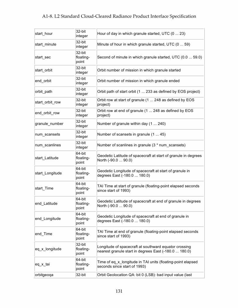
A1-8. L2 Standard Cloud-Cleared Radiance Product Interface Specification
131
start_hour 32-bit integer Hour of day in which granule started, UTC (0 ... 23)
start_minute 32-bit integer Minute of hour in which granule started, UTC (0 ... 59)
start_sec 32-bit floating-point
Second of minute in which granule started, UTC (0.0 ... 59.0)
start_orbit 32-bit integer Orbit number of mission in which granule started
end_orbit 32-bit integer Orbit number of mission in which granule ended
orbit_path 32-bit integer Orbit path of start orbit (1 ... 233 as defined by EOS project)
start_orbit_row 32-bit integer
Orbit row at start of granule (1 ... 248 as defined by EOS project)
end_orbit_row 32-bit integer
Orbit row at end of granule (1 ... 248 as defined by EOS project)
granule_number 32-bit integer Number of granule within day (1 ... 240)
num_scansets 32-bit integer Number of scansets in granule (1 ... 45)
num_scanlines 32-bit integer Number of scanlines in granule (3 * num_scansets)
start_Latitude 64-bit floating-point
Geodetic Latitude of spacecraft at start of granule in degrees North (-90.0 ... 90.0)
start_Longitude 64-bit floating-point
Geodetic Longitude of spacecraft at start of granule in degrees East (-180.0 ... 180.0)
start_Time 64-bit floating-point
TAI Time at start of granule (floating-point elapsed seconds since start of 1993)
end_Latitude 64-bit floating-point
Geodetic Latitude of spacecraft at end of granule in degrees North (-90.0 ... 90.0)
end_Longitude 64-bit floating-point
Geodetic Longitude of spacecraft at end of granule in degrees East (-180.0 ... 180.0)
end_Time 64-bit floating-point
TAI Time at end of granule (floating-point elapsed seconds since start of 1993)
eq_x_longitude 32-bit floating-point
Longitude of spacecraft at southward equator crossing nearest granule start in degrees East (-180.0 ... 180.0)
eq_x_tai 64-bit floating-point
Time of eq_x_longitude in TAI units (floating-point elapsed seconds since start of 1993)
orbitgeoqa 32-bit Orbit Geolocation QA: bit 0 (LSB): bad input value (last
A1-8. L2 Standard Cloud-Cleared Radiance Product Interface Specification
132
unsigned integer
scanline); bit 1: bad input value (first scanline); bit 2: PGS_EPH_GetEphMet() returned PGSEPH_E_NO_SC_EPHEM_FILE; bit 3: PGS_EPH_GetEphMet() returned PGSEPH_E_BAD_ARRAY_SIZE; bit 4: PGS_EPH_GetEphMet() returned PGSTD_E_TIME_FMT_ERROR; bit 5: PGS_EPH_GetEphMet() returned PGSTD_E_TIME_VALUE_ERROR; bit 6: PGS_EPH_GetEphMet() returned PGSTD_E_SC_TAG_UNKNOWN; bit 7: PGS_EPH_GetEphMet() returned PGS_E_TOOLKIT; bit 8: PGS_TD_UTCtoTAI() returned PGSTD_E_NO_LEAP_SECS; bit 9: PGS_TD_UTCtoTAI() returned PGSTD_E_TIME_FMT_ERROR; bit 10: PGS_TD_UTCtoTAI() returned PGSTD_E_TIME_VALUE_ERROR; bit 11: PGS_TD_UTCtoTAI() returned PGS_E_TOOLKIT; bit 12: PGS_CSC_DayNight() returned PGSTD_E_NO_LEAP_SECS; bit 13: PGS_CSC_DayNight() returned PGSCSC_E_INVALID_LIMITTAG; bit 14: PGS_CSC_DayNight() returned PGSCSC_E_BAD_ARRAY_SIZE; bit 15: PGS_CSC_DayNight() returned PGSCSC_W_ERROR_IN_DAYNIGHT; bit 16: PGS_CSC_DayNight() returned PGSCSC_W_BAD_TRANSFORM_VALUE; bit 17: PGS_CSC_DayNight() returned PGSCSC_W_BELOW_HORIZON; bit 18: PGS_CSC_DayNight() returned PGSCSC_W_PREDICTED_UT1; bit 19: PGS_CSC_DayNight() returned PGSTD_E_NO_UT1_VALUE; bit 20: PGS_CSC_DayNight() returned PGSTD_E_BAD_INITIAL_TIME; bit 21: PGS_CSC_DayNight() returned PGSCBP_E_TIME_OUT_OF_RANGE; bit 22: PGS_CSC_DayNight() returned PGSCBP_E_UNABLE_TO_OPEN_FILE; bit 22: PGS_CSC_DayNight() returned PGSMEM_E_NO_MEMORY; bit 24: PGS_CSC_DayNight() returned PGS_E_TOOLKIT; bit 25-31: not used
num_satgeoqa 16-bit integer Number of scans with problems in satgeoqa
num_glintgeoqa 16-bit integer Number of scans with problems in glintgeoqa
num_moongeoqa 16-bit integer Number of scans with problems in moongeoqa
num_ftptgeoqa 16-bit integer Number of footprints with problems in ftptgeoqa
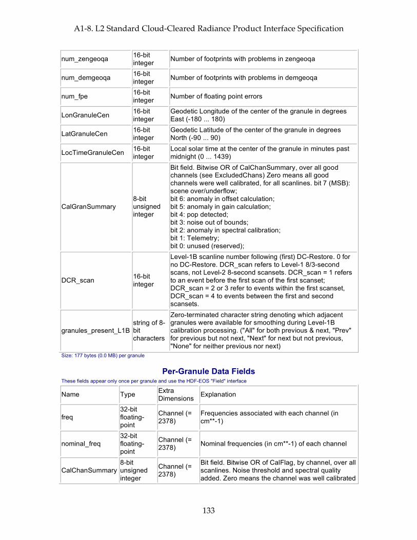
A1-8. L2 Standard Cloud-Cleared Radiance Product Interface Specification
133
num_zengeoqa 16-bit integer Number of footprints with problems in zengeoqa
num_demgeoqa 16-bit integer Number of footprints with problems in demgeoqa
num_fpe 16-bit integer Number of floating point errors
LonGranuleCen 16-bit integer
Geodetic Longitude of the center of the granule in degrees East (-180 ... 180)
LatGranuleCen 16-bit integer
Geodetic Latitude of the center of the granule in degrees North (-90 ... 90)
LocTimeGranuleCen 16-bit integer
Local solar time at the center of the granule in minutes past midnight (0 ... 1439)
CalGranSummary 8-bit unsigned integer
Bit field. Bitwise OR of CalChanSummary, over all good channels (see ExcludedChans) Zero means all good channels were well calibrated, for all scanlines. bit 7 (MSB): scene over/underflow; bit 6: anomaly in offset calculation; bit 5: anomaly in gain calculation; bit 4: pop detected; bit 3: noise out of bounds; bit 2: anomaly in spectral calibration; bit 1: Telemetry; bit 0: unused (reserved);
DCR_scan 16-bit integer
Level-1B scanline number following (first) DC-Restore. 0 for no DC-Restore. DCR_scan refers to Level-1 8/3-second scans, not Level-2 8-second scansets. DCR_scan = 1 refers to an event before the first scan of the first scanset; DCR_scan = 2 or 3 refer to events within the first scanset, DCR_scan = 4 to events between the first and second scansets.
granules_present_L1B string of 8-bit characters
Zero-terminated character string denoting which adjacent granules were available for smoothing during Level-1B calibration processing. ("All" for both previous & next, "Prev" for previous but not next, "Next" for next but not previous, "None" for neither previous nor next)
Size: 177 bytes (0.0 MB) per granule
Per-Granule Data Fields These fields appear only once per granule and use the HDF-EOS "Field" interface
Name Type Extra Dimensions Explanation
freq 32-bit floating-point
Channel (= 2378)
Frequencies associated with each channel (in cm**-1)
nominal_freq 32-bit floating-point
Channel (= 2378) Nominal frequencies (in cm**-1) of each channel
CalChanSummary 8-bit unsigned integer
Channel (= 2378)
Bit field. Bitwise OR of CalFlag, by channel, over all scanlines. Noise threshold and spectral quality added. Zero means the channel was well calibrated
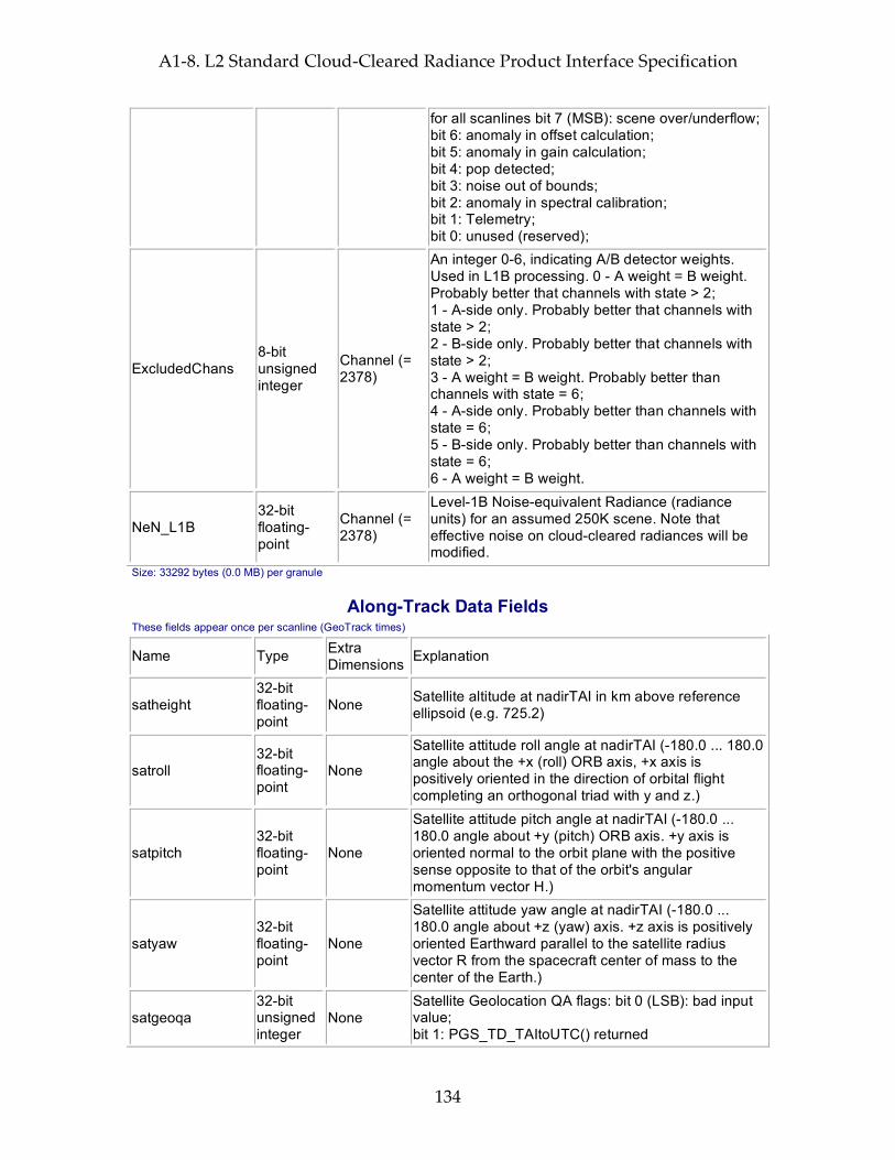
A1-8. L2 Standard Cloud-Cleared Radiance Product Interface Specification
134
for all scanlines bit 7 (MSB): scene over/underflow; bit 6: anomaly in offset calculation; bit 5: anomaly in gain calculation; bit 4: pop detected; bit 3: noise out of bounds; bit 2: anomaly in spectral calibration; bit 1: Telemetry; bit 0: unused (reserved);
ExcludedChans 8-bit unsigned integer
Channel (= 2378)
An integer 0-6, indicating A/B detector weights. Used in L1B processing. 0 - A weight = B weight. Probably better that channels with state > 2; 1 - A-side only. Probably better that channels with state > 2; 2 - B-side only. Probably better that channels with state > 2; 3 - A weight = B weight. Probably better than channels with state = 6; 4 - A-side only. Probably better than channels with state = 6; 5 - B-side only. Probably better than channels with state = 6; 6 - A weight = B weight.
NeN_L1B 32-bit floating-point
Channel (= 2378)
Level-1B Noise-equivalent Radiance (radiance units) for an assumed 250K scene. Note that effective noise on cloud-cleared radiances will be modified.
Size: 33292 bytes (0.0 MB) per granule
Along-Track Data Fields These fields appear once per scanline (GeoTrack times)
Name Type Extra Dimensions Explanation
satheight 32-bit floating-point
None Satellite altitude at nadirTAI in km above reference ellipsoid (e.g. 725.2)
satroll 32-bit floating-point
None
Satellite attitude roll angle at nadirTAI (-180.0 ... 180.0 angle about the +x (roll) ORB axis, +x axis is positively oriented in the direction of orbital flight completing an orthogonal triad with y and z.)
satpitch 32-bit floating-point
None
Satellite attitude pitch angle at nadirTAI (-180.0 ... 180.0 angle about +y (pitch) ORB axis. +y axis is oriented normal to the orbit plane with the positive sense opposite to that of the orbit's angular momentum vector H.)
satyaw 32-bit floating-point
None
Satellite attitude yaw angle at nadirTAI (-180.0 ... 180.0 angle about +z (yaw) axis. +z axis is positively oriented Earthward parallel to the satellite radius vector R from the spacecraft center of mass to the center of the Earth.)
satgeoqa 32-bit unsigned integer
None Satellite Geolocation QA flags: bit 0 (LSB): bad input value; bit 1: PGS_TD_TAItoUTC() returned

A1-8. L2 Standard Cloud-Cleared Radiance Product Interface Specification
135
PGSTD_E_NO_LEAP_SECS; bit 2: PGS_TD_TAItoUTC() returned PGS_E_TOOLKIT; bit 3: PGS_EPH_EphemAttit() returned PGSEPH_W_BAD_EPHEM_VALUE; bit 4: PGS_EPH_EphemAttit() returned PGSEPH_E_BAD_EPHEM_FILE_HDR; bit 5: PGS_EPH_EphemAttit() returned PGSEPH_E_NO_SC_EPHEM_FILE; bit 6: PGS_EPH_EphemAttit() returned PGSEPH_E_NO_DATA_REQUESTED; bit 7: PGS_EPH_EphemAttit() returned PGSTD_E_SC_TAG_UNKNOWN; bit 8: PGS_EPH_EphemAttit() returned PGSEPH_E_BAD_ARRAY_SIZE; bit 9: PGS_EPH_EphemAttit() returned PGSTD_E_TIME_FMT_ERROR; bit 10: PGS_EPH_EphemAttit() returned PGSTD_E_TIME_VALUE_ERROR; bit 11: PGS_EPH_EphemAttit() returned PGSTD_E_NO_LEAP_SECS; bit 12: PGS_EPH_EphemAttit() returned PGS_E_TOOLKIT; bit 13: PGS_CSC_ECItoECR() returned PGSCSC_W_BAD_TRANSFORM_VALUE; bit 14: PGS_CSC_ECItoECR() returned PGSCSC_E_BAD_ARRAY_SIZE; bit 15: PGS_CSC_ECItoECR() returned PGSTD_E_NO_LEAP_SECS; bit 16: PGS_CSC_ECItoECR() returned PGSTD_E_TIME_FMT_ERROR; bit 17: PGS_CSC_ECItoECR() returned PGSTD_E_TIME_VALUE_ERROR; bit 18: unused (set to zero); bit 19: PGS_CSC_ECItoECR() returned PGSTD_E_NO_UT1_VALUE; bit 20: PGS_CSC_ECItoECR() returned PGS_E_TOOLKIT; bit 21: PGS_CSC_ECRtoGEO() returned PGSCSC_W_TOO_MANY_ITERS; bit 22: PGS_CSC_ECRtoGEO() returned PGSCSC_W_INVALID_ALTITUDE; bit 23: PGS_CSC_ECRtoGEO() returned PGSCSC_W_SPHERE_BODY; bit 24: PGS_CSC_ECRtoGEO() returned PGSCSC_W_LARGE_FLATTENING; bit 25: PGS_CSC_ECRtoGEO() returned PGSCSC_W_DEFAULT_EARTH_MODEL; bit 26: PGS_CSC_ECRtoGEO() returned PGSCSC_E_BAD_EARTH_MODEL; bit 27: PGS_CSC_ECRtoGEO() returned PGS_E_TOOLKIT; bit 28-31: not used
glintgeoqa 16-bit unsigned None Glint Geolocation QA flags: bit 0 (LSB): bad input
value;

A1-8. L2 Standard Cloud-Cleared Radiance Product Interface Specification
136
integer bit 1: glint location in Earth's shadow; bit 2: glint calculation not converging; bit 3: glint location sun vs. satellite zenith mismatch; bit 4: glint location sun vs. satellite azimuth mismatch; bit 5: bad glint location; bit 6: PGS_CSC_ZenithAzimuth() returned any 'W' class return code; bit 7: PGS_CSC_ZenithAzimuth() returned any 'E' class return code; bit 8: PGS_CBP_Earth_CB_Vector() returned returned any 'W' class return code; bit 9: PGS_CBP_Earth_CB_Vector() returned returned any 'E' class return code; bit 10: PGS_CSC_ECItoECR() returned any 'W' class return code except PGSCSC_W_PREDICTED_UT1 (for Glint); bit 11: PGS_CSC_ECItoECR() returned any 'E' class return code (for Glint); bit 12: PGS_CSC_ECRtoGEO() returned any 'W' class return code (for Glint); bit 13: PGS_CSC_ECRtoGEO() returned any 'E' class return code (for Glint); bit 14: PGS_CSC_ECItoECR() returned any 'W' class return code except PGSCSC_W_PREDICTED_UT1 ; bit 15: PGS_CSC_ECItoECR() returned any 'E' class return code
moongeoqa 16-bit unsigned integer
None
Moon Geolocation QA flags: bit 0 (LSB): bad input value; bit 1: PGS_TD_TAItoUTC() returned PGSTD_E_NO_LEAP_SECS; bit 2: PGS_TD_TAItoUTC() returned PGS_E_TOOLKIT; bit 3: PGS_CBP_Sat_CB_Vector() returned PGSCSC_W_BELOW_SURFACE; bit 4: PGS_CBP_Sat_CB_Vector() returned PGSCBP_W_BAD_CB_VECTOR; bit 5: PGS_CBP_Sat_CB_Vector() returned PGSCBP_E_BAD_ARRAY_SIZE; bit 6: PGS_CBP_Sat_CB_Vector() returned PGSCBP_E_INVALID_CB_ID; bit 7: PGS_CBP_Sat_CB_Vector() returned PGSMEM_E_NO_MEMORY; bit 8: PGS_CBP_Sat_CB_Vector() returned PGSCBP_E_UNABLE_TO_OPEN_FILE; bit 9: PGS_CBP_Sat_CB_Vector() returned PGSTD_E_BAD_INITIAL_TIME; bit 10: PGS_CBP_Sat_CB_Vector() returned PGSCBP_E_TIME_OUT_OF_RANGE; bit 11: PGS_CBP_Sat_CB_Vector() returned PGSTD_E_SC_TAG_UNKNOWN; bit 12: PGS_CBP_Sat_CB_Vector() returned PGSEPH_E_BAD_EPHEM_FILE_HDR; bit 13: PGS_CBP_Sat_CB_Vector() returned PGSEPH_E_NO_SC_EPHEM_FILE; bit 14: PGS_CBP_Sat_CB_Vector() returned
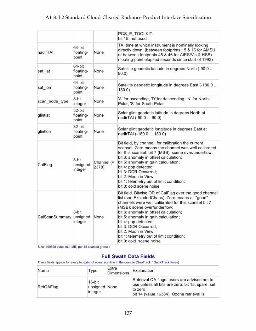
A1-8. L2 Standard Cloud-Cleared Radiance Product Interface Specification
137
PGS_E_TOOLKIT; bit 15: not used
nadirTAI 64-bit floating-point
None
TAI time at which instrument is nominally looking directly down. (between footprints 15 & 16 for AMSU or between footprints 45 & 46 for AIRS/Vis & HSB) (floating-point elapsed seconds since start of 1993)
sat_lat 64-bit floating-point
None Satellite geodetic latitude in degrees North (-90.0 ... 90.0)
sat_lon 64-bit floating-point
None Satellite geodetic longitude in degrees East (-180.0 ... 180.0)
scan_node_type 8-bit integer None 'A' for ascending, 'D' for descending, 'N' for North-
Polar, 'S' for South-Polar
glintlat 32-bit floating-point
None Solar glint geodetic latitude in degrees North at nadirTAI (-90.0 ... 90.0)
glintlon 32-bit floating-point
None Solar glint geodetic longitude in degrees East at nadirTAI (-180.0 ... 180.0)
CalFlag 8-bit unsigned integer
Channel (= 2378)
Bit field, by channel, for calibration the current scanset. Zero means the channel was well calibrated, for this scanset. bit 7 (MSB): scene over/underflow; bit 6: anomaly in offset calculation; bit 5: anomaly in gain calculation; bit 4: pop detected; bit 3: DCR Occurred; bit 2: Moon in View; bit 1: telemetry out of limit condition; bit 0: cold scene noise
CalScanSummary 8-bit unsigned integer
None
Bit field. Bitwise OR of CalFlag over the good channel list (see ExcludedChans). Zero means all "good" channels were well calibrated for this scanset bit 7 (MSB): scene over/underflow; bit 6: anomaly in offset calculation; bit 5: anomaly in gain calculation; bit 4: pop detected; bit 3: DCR Occurred; bit 2: Moon in View; bit 1: telemetry out of limit condition; bit 0: cold_scene noise
Size: 109620 bytes (0.1 MB) per 45-scanset granule
Full Swath Data Fields These fields appear for every footprint of every scanline in the granule (GeoTrack * GeoXTrack times)
Name Type Extra Dimensions Explanation
RetQAFlag 16-bit unsigned integer
None
Retrieval QA flags: users are advised not to use unless all bits are zero. bit 15: spare, set to zero.; bit 14 (value 16384): Ozone retrieval is

A1-8. L2 Standard Cloud-Cleared Radiance Product Interface Specification
138
suspect or rejected. (see Qual_O3 for details); bit 13 (value 8192): Water vapor retrieval is suspect or rejected. (see Qual_H2O for details); bit 12 (value 4096): Top part of temperature profile quality check failed or not attempted. (above Press_mid_top_bndry mbar, indices nStd_mid_top_bndry and nSup_mid_top_bndry; see Qual_Temp_Profile_Top for details); bit 11 (value 2048): Middle part of temperature profile quality check failed or not attempted. (between Press_bot_mid_bndry and Press_top_mid_bndry mbar, indices nStd_bot_mid_bndry, nSup_bot_mid_bndry, nStd_bot_mid_bndry, and nSup_bot_mid_bndry; see Qual_Temp_Profile_Mid for details); bit 10 (value 1024): Bottom part of temperature profile quality check failed or not attempted. (below Press_bot_mid_bndry mbar, indices nStd_bot_mid_bndry and nSup_bot_mid_bndry; see Qual_Temp_Profile_Bot for details); bit 9 (value 512): Surface retrieval is suspect or rejected. (see Qual_Surf for details); bit 8 (value 256): This record type not yet validated. For v4.0 all regions North of Latitude 50.0 degrees or South of Latitude -50.0 degrees will be flagged.; bits 6-7: spare, set to zero; bit 5 (value 32): Cloud retrieval rejected or not attempted; bit 4 (value 16): Final retrieval rejected or not attempted; bit 3 (value 8): Final Cloud Clearing rejected or not attempted; bit 2 (value 4): Regression First Guess rejected or not attempted; bit 1 (value 2): Initial Cloud Clearing rejected or not attempted; bit 0 (LSB, value 1): MW retrieval rejected or not attempted
Qual_CC_Rad 16-bit unsigned integer
None
Overall quality flag for cloud cleared radiances. 0: Highest Quality; 1: Good Quality; 2: Do Not Use
radiances 32-bit floating-point
Channel (= 2378)
Cloud-cleared radiances for each channel in milliWatts/m**2/cm**-1/steradian
radiance_err 32-bit floating-point
Channel (= 2378)
Error estimate for radiances (milliWatts/m**2/cm**-1/steradian)
CldClearParam 32-bit AIRSTrack Cloud clearing parameter Eta
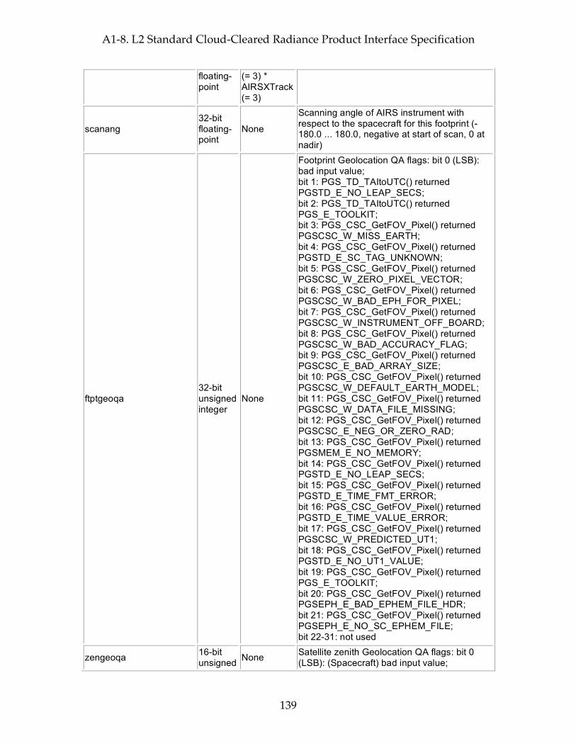
A1-8. L2 Standard Cloud-Cleared Radiance Product Interface Specification
139
floating-point
(= 3) * AIRSXTrack (= 3)
scanang 32-bit floating-point
None
Scanning angle of AIRS instrument with respect to the spacecraft for this footprint (-180.0 ... 180.0, negative at start of scan, 0 at nadir)
ftptgeoqa 32-bit unsigned integer
None
Footprint Geolocation QA flags: bit 0 (LSB): bad input value; bit 1: PGS_TD_TAItoUTC() returned PGSTD_E_NO_LEAP_SECS; bit 2: PGS_TD_TAItoUTC() returned PGS_E_TOOLKIT; bit 3: PGS_CSC_GetFOV_Pixel() returned PGSCSC_W_MISS_EARTH; bit 4: PGS_CSC_GetFOV_Pixel() returned PGSTD_E_SC_TAG_UNKNOWN; bit 5: PGS_CSC_GetFOV_Pixel() returned PGSCSC_W_ZERO_PIXEL_VECTOR; bit 6: PGS_CSC_GetFOV_Pixel() returned PGSCSC_W_BAD_EPH_FOR_PIXEL; bit 7: PGS_CSC_GetFOV_Pixel() returned PGSCSC_W_INSTRUMENT_OFF_BOARD; bit 8: PGS_CSC_GetFOV_Pixel() returned PGSCSC_W_BAD_ACCURACY_FLAG; bit 9: PGS_CSC_GetFOV_Pixel() returned PGSCSC_E_BAD_ARRAY_SIZE; bit 10: PGS_CSC_GetFOV_Pixel() returned PGSCSC_W_DEFAULT_EARTH_MODEL; bit 11: PGS_CSC_GetFOV_Pixel() returned PGSCSC_W_DATA_FILE_MISSING; bit 12: PGS_CSC_GetFOV_Pixel() returned PGSCSC_E_NEG_OR_ZERO_RAD; bit 13: PGS_CSC_GetFOV_Pixel() returned PGSMEM_E_NO_MEMORY; bit 14: PGS_CSC_GetFOV_Pixel() returned PGSTD_E_NO_LEAP_SECS; bit 15: PGS_CSC_GetFOV_Pixel() returned PGSTD_E_TIME_FMT_ERROR; bit 16: PGS_CSC_GetFOV_Pixel() returned PGSTD_E_TIME_VALUE_ERROR; bit 17: PGS_CSC_GetFOV_Pixel() returned PGSCSC_W_PREDICTED_UT1; bit 18: PGS_CSC_GetFOV_Pixel() returned PGSTD_E_NO_UT1_VALUE; bit 19: PGS_CSC_GetFOV_Pixel() returned PGS_E_TOOLKIT; bit 20: PGS_CSC_GetFOV_Pixel() returned PGSEPH_E_BAD_EPHEM_FILE_HDR; bit 21: PGS_CSC_GetFOV_Pixel() returned PGSEPH_E_NO_SC_EPHEM_FILE; bit 22-31: not used
zengeoqa 16-bit unsigned None Satellite zenith Geolocation QA flags: bit 0
(LSB): (Spacecraft) bad input value;
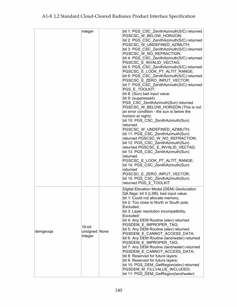
A1-8. L2 Standard Cloud-Cleared Radiance Product Interface Specification
140
integer bit 1: PGS_CSC_ZenithAzimuth(S/C) returned PGSCSC_W_BELOW_HORIZON; bit 2: PGS_CSC_ZenithAzimuth(S/C) returned PGSCSC_W_UNDEFINED_AZIMUTH; bit 3: PGS_CSC_ZenithAzimuth(S/C) returned PGSCSC_W_NO_REFRACTION; bit 4: PGS_CSC_ZenithAzimuth(S/C) returned PGSCSC_E_INVALID_VECTAG; bit 5: PGS_CSC_ZenithAzimuth(S/C) returned PGSCSC_E_LOOK_PT_ALTIT_RANGE; bit 6: PGS_CSC_ZenithAzimuth(S/C) returned PGSCSC_E_ZERO_INPUT_VECTOR; bit 7: PGS_CSC_ZenithAzimuth(S/C) returned PGS_E_TOOLKIT; bit 8: (Sun) bad input value; bit 9: (suppressed) PGS_CSC_ZenithAzimuth(Sun) returned PGSCSC_W_BELOW_HORIZON (This is not an error condition - the sun is below the horizon at night); bit 10: PGS_CSC_ZenithAzimuth(Sun) returned PGSCSC_W_UNDEFINED_AZIMUTH; bit 11: PGS_CSC_ZenithAzimuth(Sun) returned PGSCSC_W_NO_REFRACTION; bit 12: PGS_CSC_ZenithAzimuth(Sun) returned PGSCSC_E_INVALID_VECTAG; bit 13: PGS_CSC_ZenithAzimuth(Sun) returned PGSCSC_E_LOOK_PT_ALTIT_RANGE; bit 14: PGS_CSC_ZenithAzimuth(Sun) returned PGSCSC_E_ZERO_INPUT_VECTOR; bit 15: PGS_CSC_ZenithAzimuth(Sun) returned PGS_E_TOOLKIT
demgeoqa 16-bit unsigned integer
None
Digital Elevation Model (DEM) Geolocation QA flags: bit 0 (LSB): bad input value; bit 1: Could not allocate memory; bit 2: Too close to North or South pole. Excluded; bit 3: Layer resolution incompatibility. Excluded; bit 4: Any DEM Routine (elev) returned PGSDEM_E_IMPROPER_TAG; bit 5: Any DEM Routine (elev) returned PGSDEM_E_CANNOT_ACCESS_DATA; bit 6: Any DEM Routine (land/water) returned PGSDEM_E_IMPROPER_TAG; bit 7: Any DEM Routine (land/water) returned PGSDEM_E_CANNOT_ACCESS_DATA; bit 8: Reserved for future layers; bit 9: Reserved for future layers; bit 10: PGS_DEM_GetRegion(elev) returned PGSDEM_M_FILLVALUE_INCLUDED; bit 11: PGS_DEM_GetRegion(land/water)

A1-8. L2 Standard Cloud-Cleared Radiance Product Interface Specification
141
returned PGSDEM_M_FILLVALUE_INCLUDED; bit 12: Reserved for future layers; bit 13: PGS_DEM_GetRegion(all) returned PGSDEM_M_MULTIPLE_RESOLUTIONS; bit 14: PGS_CSC_GetFOV_Pixel() returned any 'W' class return code except PGSCSC_W_PREDICTED_UT1; bit 15: PGS_CSC_GetFOV_Pixel() returned any 'E' class return code
satzen 32-bit floating-point
None
Spacecraft zenith angle (0.0 ... 180.0) degrees from zenith (measured relative to the geodetic vertical on the reference (WGS84) spheroid and including corrections outlined in EOS SDP toolkit for normal accuracy.)
satazi 32-bit floating-point
None Spacecraft azimuth angle (-180.0 ... 180.0) degrees E of N GEO)
solzen 32-bit floating-point
None
Solar zenith angle (0.0 ... 180.0) degrees from zenith (measured relative to the geodetic vertical on the reference (WGS84) spheroid and including corrections outlined in EOS SDP toolkit for normal accuracy.)
solazi 32-bit floating-point
None Solar azimuth angle (-180.0 ... 180.0) degrees E of N GEO)
sun_glint_distance 16-bit integer None
Distance (km) from footprint center to location of the sun glint (-9999 for unknown, 30000 for no glint visible because spacecraft is in Earth's shadow)
topog 32-bit floating-point
None Mean topography in meters above reference ellipsoid
topog_err 32-bit floating-point
None Error estimate for topog
landFrac 32-bit floating-point
None Fraction of spot that is land (0.0 ... 1.0)
landFrac_err 32-bit floating-point
None Error estimate for landFrac
CCN_sst1231r5 32-bit floating-point
None
Experimental cloud indicator #1 -- Final cloud clearing surface temperature from BT(1231 cm-1) assuming 0.98 emissivity. sst1231r5 should agree with surface temperature retrieval over ocean within 0.5 K.
CCN_d2392r1 32-bit floating-point
None
Experimental cloud indicator #2 -- Final cloud clearing surface air temperature difference. Over ocean d2392r1 > -2.0 is a likely cloud-free spectrum.

A1-8. L2 Standard Cloud-Cleared Radiance Product Interface Specification
142
CCN_dd12g5 32-bit floating-point
None
Experimental cloud indicator #3 -- Final cloud clearing daytime gradient indicator BT(2616 cm-1) - BT(1231 cm-1) assuming 0.99 emissivity. Over ocean abs(dd12g5) < 0.5 is a likely cloud-free spectrum.
CCN_d12 32-bit floating-point
None
Experimental cloud indicator #4 -- Final cloud clearing night gradient indicator BT(2616 cm-1) - BT(1231 cm-1) assuming 0.98 emissivity. At night over ocean abs(d12) < 0.25 indicates a cloud-free spectrum.
CCN_d23 32-bit floating-point
None
Experimental cloud indicator #5 -- Final cloud clearing BT(1231 cm-1) - BT(943 cm-1) predictor for sensing thin cirrus and silicate dust. Over ocean abs(d23) > 0.25 K flags cirrus and/or silicate dust. Use in combination with d34 to discriminate silicate dust from cirrus.
CCN_d34 32-bit floating-point
None
Experimental cloud indicator #6 -- Final cloud clearing BT(943 cm-1) - BT(790 cm-1) predictor for sensing thin cirrus. abs(d34) > 0.5 K indicates cirrus. Use in combination with d23.
CCN_lrt 32-bit floating-point
None Experimental cloud indicator #7 -- Final cloud clearing Lapse rate test. lrt > 3.5 K over tropical ocean indicates cloud-free data.
CCN_g5n 32-bit floating-point
None Experimental cloud indicator #8 -- Final cloud clearing Glint discriminator. Over ocean gn5 > 3 indicates a spectrum distorted by a sun glint
CCR_pass_clear_tests 32-bit integer None
Go/No go flag based on cloud cleared radiances. 1: Cloud cleared radiances have the same spectral properties as clear ocean Level-1B IR radiances; 0: Cloud cleared radiances do NOT have the same spectral properties as clear ocean Level-1B IR radiances; -9999: Unknown
CC_noise_eff_amp_factor 32-bit floating-point
None
Effective amplification of noise in IR window channels due to extrapolation in cloud clearing and uncertainty of clear state. (< 1.0 for noise reduction, >1.0 for noise amplification, -9999.0 for unknown)
CCfinal_Resid 32-bit floating-point
None
Internal retrieval quality indicator -- residual between the final cloud cleared radiances for channels used in the determination and the radiances calculated from the best estimate of clear, in K
invalid 8-bit integer None Profile is not valid
all_spots_avg 8-bit integer None
1: the cloud clearing step judged the scene to be clear enough that it averaged all spots' radiances;

A1-8. L2 Standard Cloud-Cleared Radiance Product Interface Specification
143
0: cloud clearing was applied to the radiances; -1/255: cloud clearing not attempted
clear_lw_resid 8-bit integer None
1: Low residuals of 800-900 cm-1 window channels indicate high likelihood scene is clear; 0: High residuals of 800-900 cm-1 window channels indicate low likelihood scene is clear; -1/255: cloud clearing not attempted
MW_ret_used 8-bit integer None MW-only final retrieval used
bad_clouds 8-bit integer None invalid cloud parameters
vis_clear 8-bit integer None at least 97.2% of each IR FOV within the
AMSU FOV is clear sky
vis_cloudy 8-bit integer None at least 79.2% of each IR FOV within the
AMSU FOV is cloudy
vis_low_cloud 8-bit integer None at least 79.2% of each IR FOV within the
AMSU FOV is low_cloud
retrieval_type 8-bit integer None
Deprecated -- use RetQAFlag. Retrieval type: 0 for full retrieval; 10 for MW + final succeeded, initial retrieval failed; 20 for MW + initial succeeded, final failed; 30 for only MW stage succeeded, initial + final retrieval failed; 40 for MW + initial succeeded, final cloud-clearing failed; 50 for only MW stage succeeded, initial + final cloud-clearing failed; 100 for no retrieval;
Size: 25870050 bytes (25.9 MB) per 45-scanset granule
Total File Size (plus storage for dimensions and other HDF-EOS overhead): 26045539 bytes (26.0 MB) per 45-scanset granule = 6250.9 MB per day

A1-8. L2 Standard Cloud-Cleared Radiance Product Interface Specification
144
This page intentionally left blank.
A1-9. L2 Support Atmospheric/Surface Product Interface Specification
145
A1-9. L2 Support Atmospheric/Surface Product Interface Specification
Interface Specification Version 4.0.9.0 2005-02-01
ESDT ShortName = "AIRX2SUP"
Swath Name = "L2_Support_atmospheric&surface_product"
Level = "level2"
# Footprints = 30
# scanlines per scanset = 1
Dimensions These fields define all dimensions that can be used for HDF-EOS swath fields.
The names "GeoTrack" and "GeoXTrack" have a special meaning for this document: "Cross-Track" data fields have a hidden dimension of "GeoXTrack"; "Along-Track" data fields have a hidden dimension of "GeoTrack"; "Full Swath Data Fields have hidden dimensions of both "GeoTrack" and "GeoXTrack".
Name Value Explanation
GeoXTrack 30 Dimension across track for footprint positions. Same as number of footprints per scanline. -- starting at the left and increasing towards the right as you look along the satellite's path
GeoTrack
# of scan lines in swath
Dimension along track for footprint positions. Same as number of scanlines in granule. Parallel to the satellite's path, increasing with time. (Nominally 45 for Level-2, AMSU-A, and AIRS/Vis low-rate engineering; 135 for AIRS/Vis and HSB high-rate quantities)
StdPressureLev 28
Number of standard pressure altitude levels (from bottom of the atmosphere up); nSurfStd is the 1-based index of the first valid level for a given profile. Any levels before this are below the surface. Since the actual surface will not be be exactly at this level, it will be necessary to extrapolate or interpolate to get precise surface values. See entries for specific fields for more details.
StdPressureLay 28
Number of standard pressure altitude layers (Always equal to StdPressureLev: last layer goes to the top of the atmosphere); nSurfStd is the 1-based index of the first valid layer for a given profile. Any layers before this are below the surface. Since the actual surface will not be be exactly at the bottom of this layer, it will be necessary to extrapolate or interpolate to get total amounts for surface layers. See entries for specific fields for more details.
AIRSXTrack 3 The number of AIRS cross-track spots per AMSU-A spot. Direction is the same as GeoXTrack -- starting at the left and increasing towards the right as you look along the satellite's path
AIRSTrack 3 The number of AIRS along-track spots per AMSU-A spot. Direction is

A1-9. L2 Support Atmospheric/Surface Product Interface Specification
146
the same as GeoTrack -- parallel to the satellite's path, increasing with time
Cloud 2 Cloud layer dimension in order of increasing pressure. Only first numCloud elements are valid
ChanAMSUA 15
Dimension of AMSU-A Channel array (Channel 1: 23.8 GHz; Ch 2: 31.4 GHz; Ch 3: 50.3 GHz; Ch 4: 52.8 GHz; Ch 5: 53.596 +/- 0.115 GHz; Ch 6: 54.4 GHz; Ch 7: 54.94 GHz; Ch 8: 55.5 GHz; Ch 9: f0; Ch 10: f0 +/- 0.217 GHz Ch 11: f0 +/- df +/- 48 MHz; Ch 12: f0 +/- df +/- 22 MHz; Ch 13: f0 +/- df +/- 10 MHz; Ch 14: f0 +/- df +/- 4.5 MHz; Ch 15: 89 GHz (f0 = 57290.344 MHz; df = 322.4 MHz))
ChanHSB 5
Dimension of HSB Channel array (Channel 1: Deleted 89.0 GHz channel: always invalid; Ch 2: 150.0 GHz; Ch 3: f0 +/- 1.0 GHz; Ch 4: f0 +/- 3.0 GHz; Ch 5: f0 +/- 7.0 GHz (f0 = 183.31 GHz))
MWHingeSurf 7
Number of standard frequency hinge points in Microwave surface emissivity and surface brightness. Frequencies are 23.8, 31.4, 50.3, 52.8, 89.0, 150.0, 183.31 GHz respectively.Values are also found in field MWHingeSurfFreqGHz.
XtraPressureLev 100
Number of pressure altitude layers in high vertical resolution support products (from top of the atmosphere down); nSurfSup is the 1-based index of the last valid level for a given profile. Any levels beyond this are below the surface. Since the actual surface will not be be exactly at this level, it will be necessary to extrapolate or interpolate to get precise surface values. See entries for specific fields for more details.
XtraPressureLay 100
Number of pressure altitude layers in high vertical resolution support products (Always equal to XtraressureLev: first layer goes from the top of the atmosphere to level 1); nSurfSup is the 1-based index of the last valid layer for a given profile. Any layers beyond this are below the surface. Since the actual surface will not be be exactly at the bottom of this layer, it will be necessary to extrapolate or interpolate to get total amounts for surface layers. See entries for specific fields for more details.
HingeCloud 7 Frequency hinge points in cloud emissivity in order of increasing frequency. Only first numHingeCloud elements are valid
HingeSurfInit 50 Maximum number of frequency hinge points in IR surface emissivity from initial regression
VisXTrack 8 The number of Vis cross-track spots per AIRS. Direction is the same as GeoXTrack & AIRSXTrack -- starting at the left and increasing towards the right as you look along the satellite's path
A1-9. L2 Support Atmospheric/Surface Product Interface Specification
147
VisTrack 9
The number of Vis along-track spots per AIRS. Direction is the same as GeoTrack & AIRSTrack -- parallel to the satellite's path, increasing with time. (opposite order to detector ordering -- detector 0 is last)
VChn 4 The number of Visible channels
ScoresBand 10 The number of IR frequency bands for which Initial_CC_subscores are calculated. Band limits are (in cm^-1): 645., 704., 800., 1000., 1200., 2200., 2304., 2382., 2390., 2400., 2600.
CCTest 10 The number of cloud-clearing tests
VisGeoSpots 4
Geolocations for the 4 corner pixels in the order: trailing first scanned; trailing last-scanned; leading first-scanned; leading last-scanned. Each footprint also has a central geolocation associated with the swath geolocation lat/lon/time of the footprint.
MODISEmisBand 6 MODIS bands for IR emissivity first guess: 833.33, 909.09, 1169.6, 2469.1, 2531.6, and 2666.7 cm**-1.
Geolocation Fields These fields appear for every footprint (GeoTrack * GeoXTrack times) and correspond to footprint center coordinates and "shutter" time.
Name Explanation Latitude Footprint boresight geodetic Latitude in degrees North (-90.0 ... 90.0) Longitude Footprint boresight geodetic Longitude in degrees East (-180.0 ... 180.0) Time Footprint "shutter" TAI Time: floating-point elapsed seconds since Jan 1, 1993 Size: 32400 bytes (0.0 MB) per 45-scanset granule
Attributes These fields appear only once per granule and use the HDF-EOS "Attribute" interface
Name Type Explanation
processing_level string of 8-bit characters
Zero-terminated character string denoting processing level ("level2")
instrument string of 8-bit characters
Zero-terminated character string denoting instrument ("AIRS")
DayNightFlag string of 8-bit characters
Zero-terminated character string set to "Night" when the subsatellite points at the beginning and end of a granule are both experiencing night according to the "civil twilight" standard (center of refracted sun is more than 6 degrees below the horizon). It is set to "Day" when both are experiencing day, and "Both" when one is experiencing day and the other night. "NA" is used when a determination cannot be made.
AutomaticQAFlag string of 8-bit characters
Zero-terminated character string denoting granule data quality: (Always "Passed", "Failed", or "Suspect")
NumTotalData 32-bit integer Total number of expected scene footprints
A1-9. L2 Support Atmospheric/Surface Product Interface Specification
148
NumProcessData 32-bit integer
Number of scene footprints which are present and can be processed routinely (state = 0)
NumSpecialData 32-bit integer
Number of scene footprints which are present and can be processed only as a special test (state = 1)
NumBadData 32-bit integer
Number of scene footprints which are present but cannot be processed (state = 2)
NumMissingData 32-bit integer
Number of expected scene footprints which are not present (state = 3)
NumLandSurface 32-bit integer
Number of scene footprints for which the surface is more than 90% land
NumOceanSurface 32-bit integer
Number of scene footprints for which the surface is less than 10% land
node_type string of 8-bit characters
Zero-terminated character string denoting whether granule is ascending, descending, or pole-crossing: ("Ascending" and "Descending" for entirely ascending or entirely descending granules, or "NorthPole" or "SouthPole" for pole-crossing granules. "NA" when determination cannot be made.)
start_year 32-bit integer Year in which granule started, UTC (e.g. 1999)
start_month 32-bit integer Month in which granule started, UTC (1 ... 12)
start_day 32-bit integer Day of month in which granule started, UTC (1 ... 31)
start_hour 32-bit integer Hour of day in which granule started, UTC (0 ... 23)
start_minute 32-bit integer Minute of hour in which granule started, UTC (0 ... 59)
start_sec 32-bit floating-point
Second of minute in which granule started, UTC (0.0 ... 59.0)
start_orbit 32-bit integer Orbit number of mission in which granule started
end_orbit 32-bit integer Orbit number of mission in which granule ended
orbit_path 32-bit integer Orbit path of start orbit (1 ... 233 as defined by EOS project)
start_orbit_row 32-bit integer
Orbit row at start of granule (1 ... 248 as defined by EOS project)
end_orbit_row 32-bit integer
Orbit row at end of granule (1 ... 248 as defined by EOS project)
granule_number 32-bit integer Number of granule within day (1 ... 240)
num_scansets 32-bit integer Number of scansets in granule (1 ... 45)
num_scanlines 32-bit integer Number of scanlines in granule (1 * num_scansets)
start_Latitude 64-bit Geodetic Latitude of spacecraft at start of granule in degrees
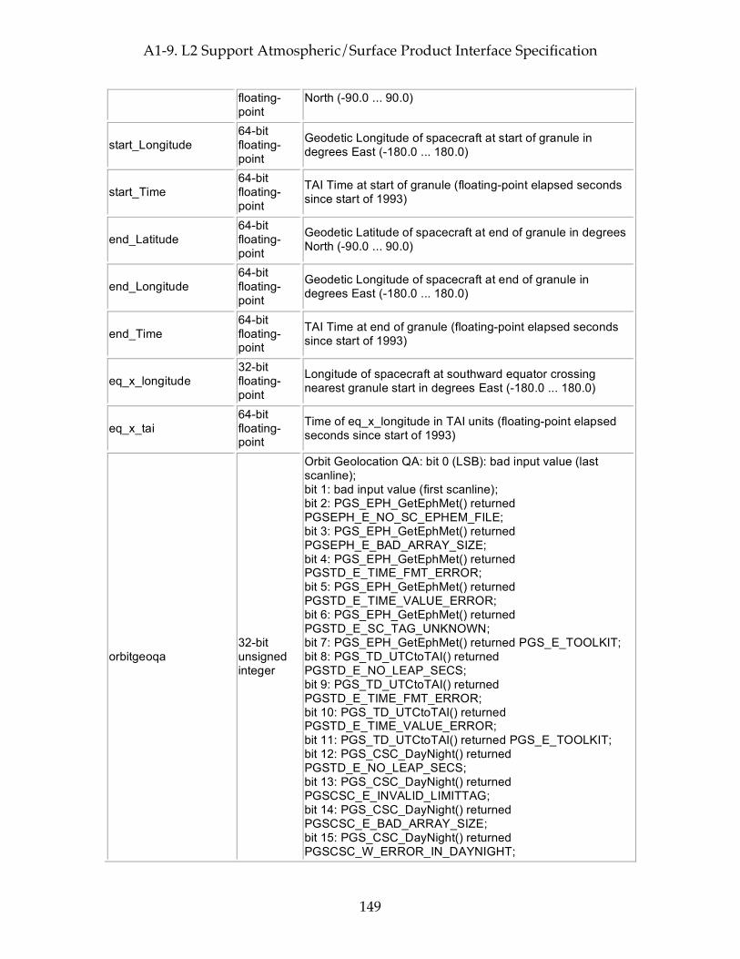
A1-9. L2 Support Atmospheric/Surface Product Interface Specification
149
floating-point
North (-90.0 ... 90.0)
start_Longitude 64-bit floating-point
Geodetic Longitude of spacecraft at start of granule in degrees East (-180.0 ... 180.0)
start_Time 64-bit floating-point
TAI Time at start of granule (floating-point elapsed seconds since start of 1993)
end_Latitude 64-bit floating-point
Geodetic Latitude of spacecraft at end of granule in degrees North (-90.0 ... 90.0)
end_Longitude 64-bit floating-point
Geodetic Longitude of spacecraft at end of granule in degrees East (-180.0 ... 180.0)
end_Time 64-bit floating-point
TAI Time at end of granule (floating-point elapsed seconds since start of 1993)
eq_x_longitude 32-bit floating-point
Longitude of spacecraft at southward equator crossing nearest granule start in degrees East (-180.0 ... 180.0)
eq_x_tai 64-bit floating-point
Time of eq_x_longitude in TAI units (floating-point elapsed seconds since start of 1993)
orbitgeoqa 32-bit unsigned integer
Orbit Geolocation QA: bit 0 (LSB): bad input value (last scanline); bit 1: bad input value (first scanline); bit 2: PGS_EPH_GetEphMet() returned PGSEPH_E_NO_SC_EPHEM_FILE; bit 3: PGS_EPH_GetEphMet() returned PGSEPH_E_BAD_ARRAY_SIZE; bit 4: PGS_EPH_GetEphMet() returned PGSTD_E_TIME_FMT_ERROR; bit 5: PGS_EPH_GetEphMet() returned PGSTD_E_TIME_VALUE_ERROR; bit 6: PGS_EPH_GetEphMet() returned PGSTD_E_SC_TAG_UNKNOWN; bit 7: PGS_EPH_GetEphMet() returned PGS_E_TOOLKIT; bit 8: PGS_TD_UTCtoTAI() returned PGSTD_E_NO_LEAP_SECS; bit 9: PGS_TD_UTCtoTAI() returned PGSTD_E_TIME_FMT_ERROR; bit 10: PGS_TD_UTCtoTAI() returned PGSTD_E_TIME_VALUE_ERROR; bit 11: PGS_TD_UTCtoTAI() returned PGS_E_TOOLKIT; bit 12: PGS_CSC_DayNight() returned PGSTD_E_NO_LEAP_SECS; bit 13: PGS_CSC_DayNight() returned PGSCSC_E_INVALID_LIMITTAG; bit 14: PGS_CSC_DayNight() returned PGSCSC_E_BAD_ARRAY_SIZE; bit 15: PGS_CSC_DayNight() returned PGSCSC_W_ERROR_IN_DAYNIGHT;
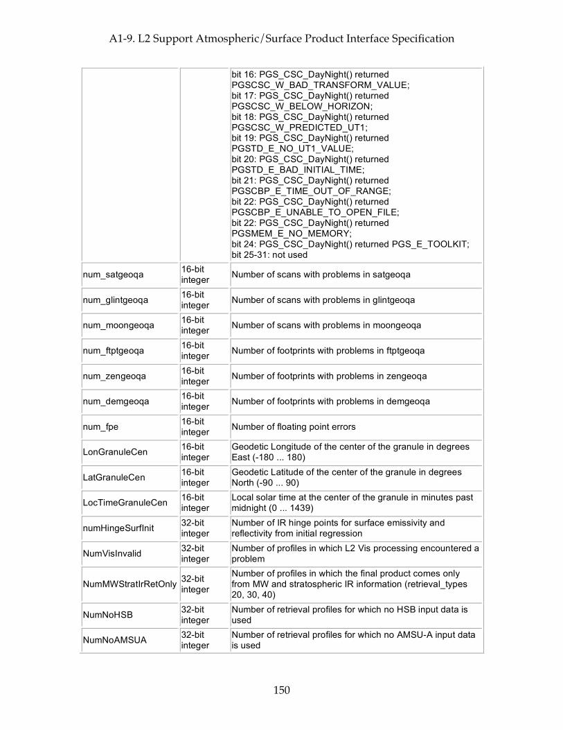
A1-9. L2 Support Atmospheric/Surface Product Interface Specification
150
bit 16: PGS_CSC_DayNight() returned PGSCSC_W_BAD_TRANSFORM_VALUE; bit 17: PGS_CSC_DayNight() returned PGSCSC_W_BELOW_HORIZON; bit 18: PGS_CSC_DayNight() returned PGSCSC_W_PREDICTED_UT1; bit 19: PGS_CSC_DayNight() returned PGSTD_E_NO_UT1_VALUE; bit 20: PGS_CSC_DayNight() returned PGSTD_E_BAD_INITIAL_TIME; bit 21: PGS_CSC_DayNight() returned PGSCBP_E_TIME_OUT_OF_RANGE; bit 22: PGS_CSC_DayNight() returned PGSCBP_E_UNABLE_TO_OPEN_FILE; bit 22: PGS_CSC_DayNight() returned PGSMEM_E_NO_MEMORY; bit 24: PGS_CSC_DayNight() returned PGS_E_TOOLKIT; bit 25-31: not used
num_satgeoqa 16-bit integer Number of scans with problems in satgeoqa
num_glintgeoqa 16-bit integer Number of scans with problems in glintgeoqa
num_moongeoqa 16-bit integer Number of scans with problems in moongeoqa
num_ftptgeoqa 16-bit integer Number of footprints with problems in ftptgeoqa
num_zengeoqa 16-bit integer Number of footprints with problems in zengeoqa
num_demgeoqa 16-bit integer Number of footprints with problems in demgeoqa
num_fpe 16-bit integer Number of floating point errors
LonGranuleCen 16-bit integer
Geodetic Longitude of the center of the granule in degrees East (-180 ... 180)
LatGranuleCen 16-bit integer
Geodetic Latitude of the center of the granule in degrees North (-90 ... 90)
LocTimeGranuleCen 16-bit integer
Local solar time at the center of the granule in minutes past midnight (0 ... 1439)
numHingeSurfInit 32-bit integer
Number of IR hinge points for surface emissivity and reflectivity from initial regression
NumVisInvalid 32-bit integer
Number of profiles in which L2 Vis processing encountered a problem
NumMWStratIrRetOnly 32-bit integer
Number of profiles in which the final product comes only from MW and stratospheric IR information (retrieval_types 20, 30, 40)
NumNoHSB 32-bit integer
Number of retrieval profiles for which no HSB input data is used
NumNoAMSUA 32-bit integer
Number of retrieval profiles for which no AMSU-A input data is used

A1-9. L2 Support Atmospheric/Surface Product Interface Specification
151
NumNoAIRS 32-bit integer
Number of retrieval profiles for which no AIRS-IR input data is used
NumNoVis 32-bit integer
Number of retrieval profiles for which no AIRS-V/NIR input data is used
DCRCount 32-bit integer
Number of times a Direct Current Restore was executed for any module
PopCount 32-bit integer
Number of popcorn events within granule, i.e. number of times than an AIRS channel used in the Level 2 retrieval has suffered a sudden discontinuity in dark current
MoonInViewMWCount 32-bit integer
Number of scanlines in granule with the moon in a Microwave space view (approx)
VegMapFileName string of 8-bit characters
Name of input file used as Vegetation Map
Size: 214 bytes (0.0 MB) per granule
Per-Granule Data Fields These fields appear only once per granule and use the HDF-EOS "Field" interface
Name Type Extra Dimensions Explanation
pressSupp 32-bit floating-point
XtraPressureLev (= 100)
Support pressures (lower boundary) in mbar.
MWHingeSurfFreqGHz 32-bit floating-point
MWHingeSurf (= 7)
Frequencies in GHz for MW surface parameters (SfcTbMWStd, EmisMWStd,...)
freqEmisInit 32-bit floating-point
HingeSurfInit (= 50)
Frequencies for surface emissivity and reflectivity in cm-1 (in order of increasing frequency. Only first numHingeSurfInit elements are valid)
rhoVisErr 8-bit integer
VisTrack (= 9) * VChn (= 4) Error estimate for rhoVis
Size: 664 bytes (0.0 MB) per granule
Along-Track Data Fields These fields appear once per scanline (GeoTrack times)
Name Type Extra Dimensions Explanation
satheight 32-bit floating-point
None Satellite altitude at nadirTAI in km above reference ellipsoid (e.g. 725.2)
satroll 32-bit floating-point
None
Satellite attitude roll angle at nadirTAI (-180.0 ... 180.0 angle about the +x (roll) ORB axis, +x axis is positively oriented in the direction of orbital flight completing an orthogonal triad with y and z.)
satpitch 32-bit floating-point
None
Satellite attitude pitch angle at nadirTAI (-180.0 ... 180.0 angle about +y (pitch) ORB axis. +y axis is oriented normal to the orbit plane with the positive sense opposite to that of the orbit's angular momentum vector H.)
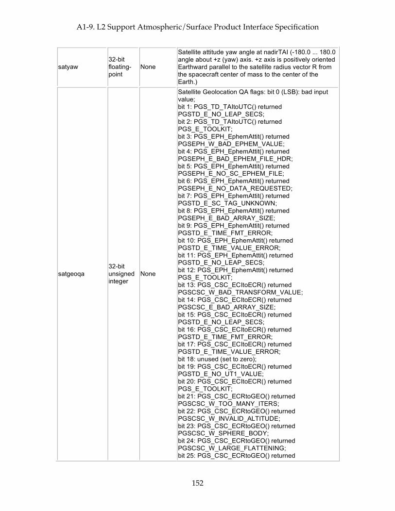
A1-9. L2 Support Atmospheric/Surface Product Interface Specification
152
satyaw 32-bit floating-point
None
Satellite attitude yaw angle at nadirTAI (-180.0 ... 180.0 angle about +z (yaw) axis. +z axis is positively oriented Earthward parallel to the satellite radius vector R from the spacecraft center of mass to the center of the Earth.)
satgeoqa 32-bit unsigned integer
None
Satellite Geolocation QA flags: bit 0 (LSB): bad input value; bit 1: PGS_TD_TAItoUTC() returned PGSTD_E_NO_LEAP_SECS; bit 2: PGS_TD_TAItoUTC() returned PGS_E_TOOLKIT; bit 3: PGS_EPH_EphemAttit() returned PGSEPH_W_BAD_EPHEM_VALUE; bit 4: PGS_EPH_EphemAttit() returned PGSEPH_E_BAD_EPHEM_FILE_HDR; bit 5: PGS_EPH_EphemAttit() returned PGSEPH_E_NO_SC_EPHEM_FILE; bit 6: PGS_EPH_EphemAttit() returned PGSEPH_E_NO_DATA_REQUESTED; bit 7: PGS_EPH_EphemAttit() returned PGSTD_E_SC_TAG_UNKNOWN; bit 8: PGS_EPH_EphemAttit() returned PGSEPH_E_BAD_ARRAY_SIZE; bit 9: PGS_EPH_EphemAttit() returned PGSTD_E_TIME_FMT_ERROR; bit 10: PGS_EPH_EphemAttit() returned PGSTD_E_TIME_VALUE_ERROR; bit 11: PGS_EPH_EphemAttit() returned PGSTD_E_NO_LEAP_SECS; bit 12: PGS_EPH_EphemAttit() returned PGS_E_TOOLKIT; bit 13: PGS_CSC_ECItoECR() returned PGSCSC_W_BAD_TRANSFORM_VALUE; bit 14: PGS_CSC_ECItoECR() returned PGSCSC_E_BAD_ARRAY_SIZE; bit 15: PGS_CSC_ECItoECR() returned PGSTD_E_NO_LEAP_SECS; bit 16: PGS_CSC_ECItoECR() returned PGSTD_E_TIME_FMT_ERROR; bit 17: PGS_CSC_ECItoECR() returned PGSTD_E_TIME_VALUE_ERROR; bit 18: unused (set to zero); bit 19: PGS_CSC_ECItoECR() returned PGSTD_E_NO_UT1_VALUE; bit 20: PGS_CSC_ECItoECR() returned PGS_E_TOOLKIT; bit 21: PGS_CSC_ECRtoGEO() returned PGSCSC_W_TOO_MANY_ITERS; bit 22: PGS_CSC_ECRtoGEO() returned PGSCSC_W_INVALID_ALTITUDE; bit 23: PGS_CSC_ECRtoGEO() returned PGSCSC_W_SPHERE_BODY; bit 24: PGS_CSC_ECRtoGEO() returned PGSCSC_W_LARGE_FLATTENING; bit 25: PGS_CSC_ECRtoGEO() returned
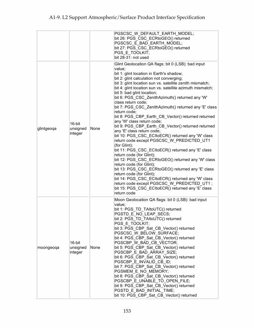
A1-9. L2 Support Atmospheric/Surface Product Interface Specification
153
PGSCSC_W_DEFAULT_EARTH_MODEL; bit 26: PGS_CSC_ECRtoGEO() returned PGSCSC_E_BAD_EARTH_MODEL; bit 27: PGS_CSC_ECRtoGEO() returned PGS_E_TOOLKIT; bit 28-31: not used
glintgeoqa 16-bit unsigned integer
None
Glint Geolocation QA flags: bit 0 (LSB): bad input value; bit 1: glint location in Earth's shadow; bit 2: glint calculation not converging; bit 3: glint location sun vs. satellite zenith mismatch; bit 4: glint location sun vs. satellite azimuth mismatch; bit 5: bad glint location; bit 6: PGS_CSC_ZenithAzimuth() returned any 'W' class return code; bit 7: PGS_CSC_ZenithAzimuth() returned any 'E' class return code; bit 8: PGS_CBP_Earth_CB_Vector() returned returned any 'W' class return code; bit 9: PGS_CBP_Earth_CB_Vector() returned returned any 'E' class return code; bit 10: PGS_CSC_ECItoECR() returned any 'W' class return code except PGSCSC_W_PREDICTED_UT1 (for Glint); bit 11: PGS_CSC_ECItoECR() returned any 'E' class return code (for Glint); bit 12: PGS_CSC_ECRtoGEO() returned any 'W' class return code (for Glint); bit 13: PGS_CSC_ECRtoGEO() returned any 'E' class return code (for Glint); bit 14: PGS_CSC_ECItoECR() returned any 'W' class return code except PGSCSC_W_PREDICTED_UT1 ; bit 15: PGS_CSC_ECItoECR() returned any 'E' class return code
moongeoqa 16-bit unsigned integer
None
Moon Geolocation QA flags: bit 0 (LSB): bad input value; bit 1: PGS_TD_TAItoUTC() returned PGSTD_E_NO_LEAP_SECS; bit 2: PGS_TD_TAItoUTC() returned PGS_E_TOOLKIT; bit 3: PGS_CBP_Sat_CB_Vector() returned PGSCSC_W_BELOW_SURFACE; bit 4: PGS_CBP_Sat_CB_Vector() returned PGSCBP_W_BAD_CB_VECTOR; bit 5: PGS_CBP_Sat_CB_Vector() returned PGSCBP_E_BAD_ARRAY_SIZE; bit 6: PGS_CBP_Sat_CB_Vector() returned PGSCBP_E_INVALID_CB_ID; bit 7: PGS_CBP_Sat_CB_Vector() returned PGSMEM_E_NO_MEMORY; bit 8: PGS_CBP_Sat_CB_Vector() returned PGSCBP_E_UNABLE_TO_OPEN_FILE; bit 9: PGS_CBP_Sat_CB_Vector() returned PGSTD_E_BAD_INITIAL_TIME; bit 10: PGS_CBP_Sat_CB_Vector() returned
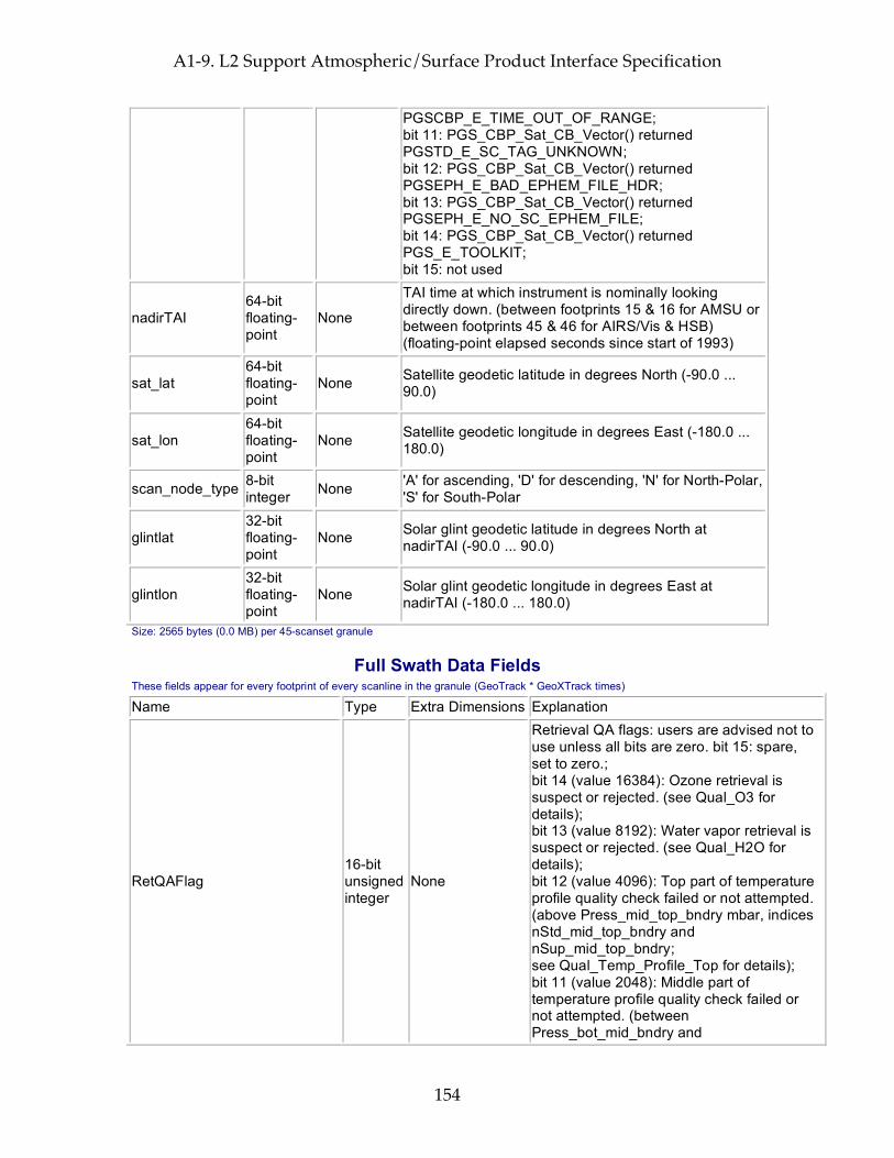
A1-9. L2 Support Atmospheric/Surface Product Interface Specification
154
PGSCBP_E_TIME_OUT_OF_RANGE; bit 11: PGS_CBP_Sat_CB_Vector() returned PGSTD_E_SC_TAG_UNKNOWN; bit 12: PGS_CBP_Sat_CB_Vector() returned PGSEPH_E_BAD_EPHEM_FILE_HDR; bit 13: PGS_CBP_Sat_CB_Vector() returned PGSEPH_E_NO_SC_EPHEM_FILE; bit 14: PGS_CBP_Sat_CB_Vector() returned PGS_E_TOOLKIT; bit 15: not used
nadirTAI 64-bit floating-point
None
TAI time at which instrument is nominally looking directly down. (between footprints 15 & 16 for AMSU or between footprints 45 & 46 for AIRS/Vis & HSB) (floating-point elapsed seconds since start of 1993)
sat_lat 64-bit floating-point
None Satellite geodetic latitude in degrees North (-90.0 ... 90.0)
sat_lon 64-bit floating-point
None Satellite geodetic longitude in degrees East (-180.0 ... 180.0)
scan_node_type 8-bit integer None 'A' for ascending, 'D' for descending, 'N' for North-Polar,
'S' for South-Polar
glintlat 32-bit floating-point
None Solar glint geodetic latitude in degrees North at nadirTAI (-90.0 ... 90.0)
glintlon 32-bit floating-point
None Solar glint geodetic longitude in degrees East at nadirTAI (-180.0 ... 180.0)
Size: 2565 bytes (0.0 MB) per 45-scanset granule
Full Swath Data Fields These fields appear for every footprint of every scanline in the granule (GeoTrack * GeoXTrack times)
Name Type Extra Dimensions Explanation
RetQAFlag 16-bit unsigned integer
None
Retrieval QA flags: users are advised not to use unless all bits are zero. bit 15: spare, set to zero.; bit 14 (value 16384): Ozone retrieval is suspect or rejected. (see Qual_O3 for details); bit 13 (value 8192): Water vapor retrieval is suspect or rejected. (see Qual_H2O for details); bit 12 (value 4096): Top part of temperature profile quality check failed or not attempted. (above Press_mid_top_bndry mbar, indices nStd_mid_top_bndry and nSup_mid_top_bndry; see Qual_Temp_Profile_Top for details); bit 11 (value 2048): Middle part of temperature profile quality check failed or not attempted. (between Press_bot_mid_bndry and

A1-9. L2 Support Atmospheric/Surface Product Interface Specification
155
Press_top_mid_bndry mbar, indices nStd_bot_mid_bndry, nSup_bot_mid_bndry, nStd_bot_mid_bndry, and nSup_bot_mid_bndry; see Qual_Temp_Profile_Mid for details); bit 10 (value 1024): Bottom part of temperature profile quality check failed or not attempted. (below Press_bot_mid_bndry mbar, indices nStd_bot_mid_bndry and nSup_bot_mid_bndry; see Qual_Temp_Profile_Bot for details); bit 9 (value 512): Surface retrieval is suspect or rejected. (see Qual_Surf for details); bit 8 (value 256): This record type not yet validated. For v4.0 all regions North of Latitude 50.0 degrees or South of Latitude -50.0 degrees will be flagged.; bits 6-7: spare, set to zero; bit 5 (value 32): Cloud retrieval rejected or not attempted; bit 4 (value 16): Final retrieval rejected or not attempted; bit 3 (value 8): Final Cloud Clearing rejected or not attempted; bit 2 (value 4): Regression First Guess rejected or not attempted; bit 1 (value 2): Initial Cloud Clearing rejected or not attempted; bit 0 (LSB, value 1): MW retrieval rejected or not attempted
Qual_MW_Only_Temp_Strat 16-bit unsigned integer
None
Overall quality flag for MW-Only temperature fields for altitudes above 201 mbar. 0: Highest Quality; 1: Good Quality; 2: Do Not Use
Qual_MW_Only_Temp_Tropo 16-bit unsigned integer
None
Overall quality flag for MW-Only temperature fields for altitudes at and below 201 mbar, including surface temperature. 0: Highest Quality; 1: Good Quality; 2: Do Not Use
Qual_MW_Only_H2O 16-bit unsigned integer
None
Overall quality flag for MW-Only water (both vapor and liquid) fields. 0: Highest Quality; 1: Good Quality; 2: Do Not Use
Qual_Cloud_OLR 16-bit unsigned integer
None
Overall quality flag for cloud parameters and clear and cloudy OLR. 0: Highest Quality; 1: Good Quality; 2: Do Not Use
Qual_H2O 16-bit unsigned integer
None
Overall quality flag for water vapor fields. 0: Highest Quality; 1: Good Quality; 2: Do Not Use
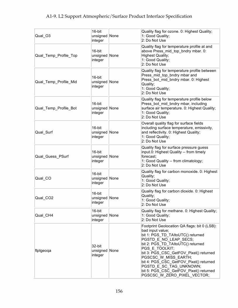
A1-9. L2 Support Atmospheric/Surface Product Interface Specification
156
Qual_O3 16-bit unsigned integer
None Quality flag for ozone. 0: Highest Quality; 1: Good Quality; 2: Do Not Use
Qual_Temp_Profile_Top 16-bit unsigned integer
None
Quality flag for temperature profile at and above Press_mid_top_bndry mbar. 0: Highest Quality; 1: Good Quality; 2: Do Not Use
Qual_Temp_Profile_Mid 16-bit unsigned integer
None
Quality flag for temperature profile between Press_mid_top_bndry mbar and Press_bot_mid_bndry mbar. 0: Highest Quality; 1: Good Quality; 2: Do Not Use
Qual_Temp_Profile_Bot 16-bit unsigned integer
None
Quality flag for temperature profile below Press_bot_mid_bndry mbar, including surface air temperature. 0: Highest Quality; 1: Good Quality; 2: Do Not Use
Qual_Surf 16-bit unsigned integer
None
Overall quality flag for surface fields including surface temperature, emissivity, and reflectivity. 0: Highest Quality; 1: Good Quality; 2: Do Not Use
Qual_Guess_PSurf 16-bit unsigned integer
None
Quality flag for surface pressure guess input.0: Highest Quality -- from timely forecast; 1: Good Quality -- from climatology; 2: Do Not Use
Qual_CO 16-bit unsigned integer
None
Quality flag for carbon monoxide. 0: Highest Quality; 1: Good Quality; 2: Do Not Use
Qual_CO2 16-bit unsigned integer
None
Quality flag for carbon dioxide. 0: Highest Quality; 1: Good Quality; 2: Do Not Use
Qual_CH4 16-bit unsigned integer
None Quality flag for methane. 0: Highest Quality; 1: Good Quality; 2: Do Not Use
ftptgeoqa 32-bit unsigned integer
None
Footprint Geolocation QA flags: bit 0 (LSB): bad input value; bit 1: PGS_TD_TAItoUTC() returned PGSTD_E_NO_LEAP_SECS; bit 2: PGS_TD_TAItoUTC() returned PGS_E_TOOLKIT; bit 3: PGS_CSC_GetFOV_Pixel() returned PGSCSC_W_MISS_EARTH; bit 4: PGS_CSC_GetFOV_Pixel() returned PGSTD_E_SC_TAG_UNKNOWN; bit 5: PGS_CSC_GetFOV_Pixel() returned PGSCSC_W_ZERO_PIXEL_VECTOR;
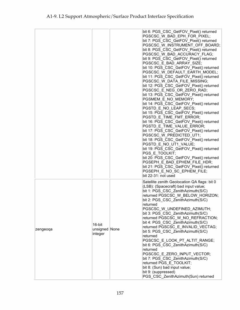
A1-9. L2 Support Atmospheric/Surface Product Interface Specification
157
bit 6: PGS_CSC_GetFOV_Pixel() returned PGSCSC_W_BAD_EPH_FOR_PIXEL; bit 7: PGS_CSC_GetFOV_Pixel() returned PGSCSC_W_INSTRUMENT_OFF_BOARD; bit 8: PGS_CSC_GetFOV_Pixel() returned PGSCSC_W_BAD_ACCURACY_FLAG; bit 9: PGS_CSC_GetFOV_Pixel() returned PGSCSC_E_BAD_ARRAY_SIZE; bit 10: PGS_CSC_GetFOV_Pixel() returned PGSCSC_W_DEFAULT_EARTH_MODEL; bit 11: PGS_CSC_GetFOV_Pixel() returned PGSCSC_W_DATA_FILE_MISSING; bit 12: PGS_CSC_GetFOV_Pixel() returned PGSCSC_E_NEG_OR_ZERO_RAD; bit 13: PGS_CSC_GetFOV_Pixel() returned PGSMEM_E_NO_MEMORY; bit 14: PGS_CSC_GetFOV_Pixel() returned PGSTD_E_NO_LEAP_SECS; bit 15: PGS_CSC_GetFOV_Pixel() returned PGSTD_E_TIME_FMT_ERROR; bit 16: PGS_CSC_GetFOV_Pixel() returned PGSTD_E_TIME_VALUE_ERROR; bit 17: PGS_CSC_GetFOV_Pixel() returned PGSCSC_W_PREDICTED_UT1; bit 18: PGS_CSC_GetFOV_Pixel() returned PGSTD_E_NO_UT1_VALUE; bit 19: PGS_CSC_GetFOV_Pixel() returned PGS_E_TOOLKIT; bit 20: PGS_CSC_GetFOV_Pixel() returned PGSEPH_E_BAD_EPHEM_FILE_HDR; bit 21: PGS_CSC_GetFOV_Pixel() returned PGSEPH_E_NO_SC_EPHEM_FILE; bit 22-31: not used
zengeoqa 16-bit unsigned integer
None
Satellite zenith Geolocation QA flags: bit 0 (LSB): (Spacecraft) bad input value; bit 1: PGS_CSC_ZenithAzimuth(S/C) returned PGSCSC_W_BELOW_HORIZON; bit 2: PGS_CSC_ZenithAzimuth(S/C) returned PGSCSC_W_UNDEFINED_AZIMUTH; bit 3: PGS_CSC_ZenithAzimuth(S/C) returned PGSCSC_W_NO_REFRACTION; bit 4: PGS_CSC_ZenithAzimuth(S/C) returned PGSCSC_E_INVALID_VECTAG; bit 5: PGS_CSC_ZenithAzimuth(S/C) returned PGSCSC_E_LOOK_PT_ALTIT_RANGE; bit 6: PGS_CSC_ZenithAzimuth(S/C) returned PGSCSC_E_ZERO_INPUT_VECTOR; bit 7: PGS_CSC_ZenithAzimuth(S/C) returned PGS_E_TOOLKIT; bit 8: (Sun) bad input value; bit 9: (suppressed) PGS_CSC_ZenithAzimuth(Sun) returned
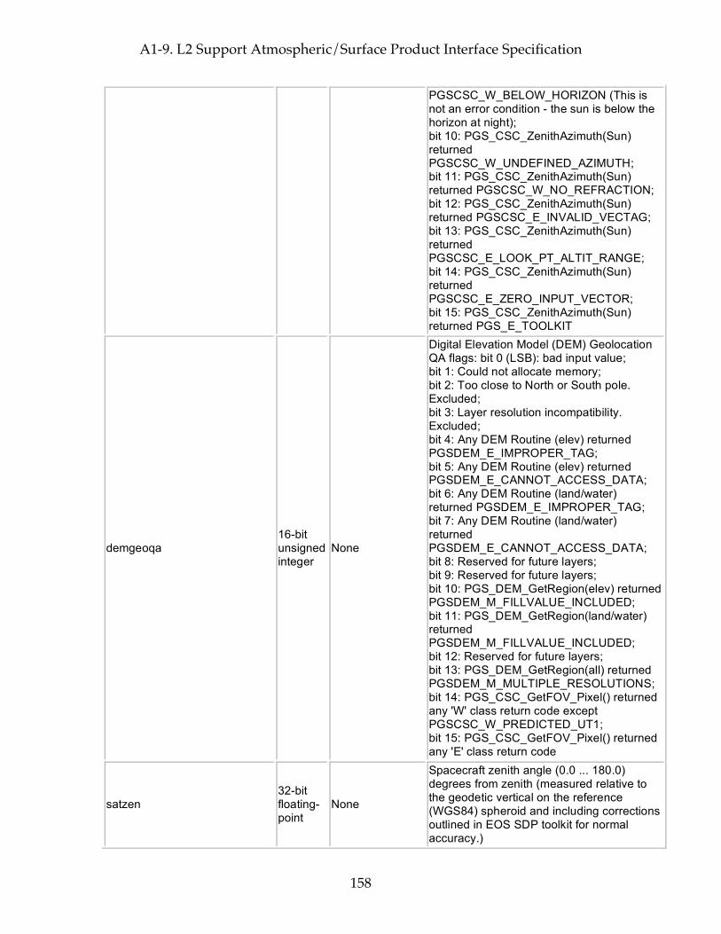
A1-9. L2 Support Atmospheric/Surface Product Interface Specification
158
PGSCSC_W_BELOW_HORIZON (This is not an error condition - the sun is below the horizon at night); bit 10: PGS_CSC_ZenithAzimuth(Sun) returned PGSCSC_W_UNDEFINED_AZIMUTH; bit 11: PGS_CSC_ZenithAzimuth(Sun) returned PGSCSC_W_NO_REFRACTION; bit 12: PGS_CSC_ZenithAzimuth(Sun) returned PGSCSC_E_INVALID_VECTAG; bit 13: PGS_CSC_ZenithAzimuth(Sun) returned PGSCSC_E_LOOK_PT_ALTIT_RANGE; bit 14: PGS_CSC_ZenithAzimuth(Sun) returned PGSCSC_E_ZERO_INPUT_VECTOR; bit 15: PGS_CSC_ZenithAzimuth(Sun) returned PGS_E_TOOLKIT
demgeoqa 16-bit unsigned integer
None
Digital Elevation Model (DEM) Geolocation QA flags: bit 0 (LSB): bad input value; bit 1: Could not allocate memory; bit 2: Too close to North or South pole. Excluded; bit 3: Layer resolution incompatibility. Excluded; bit 4: Any DEM Routine (elev) returned PGSDEM_E_IMPROPER_TAG; bit 5: Any DEM Routine (elev) returned PGSDEM_E_CANNOT_ACCESS_DATA; bit 6: Any DEM Routine (land/water) returned PGSDEM_E_IMPROPER_TAG; bit 7: Any DEM Routine (land/water) returned PGSDEM_E_CANNOT_ACCESS_DATA; bit 8: Reserved for future layers; bit 9: Reserved for future layers; bit 10: PGS_DEM_GetRegion(elev) returned PGSDEM_M_FILLVALUE_INCLUDED; bit 11: PGS_DEM_GetRegion(land/water) returned PGSDEM_M_FILLVALUE_INCLUDED; bit 12: Reserved for future layers; bit 13: PGS_DEM_GetRegion(all) returned PGSDEM_M_MULTIPLE_RESOLUTIONS; bit 14: PGS_CSC_GetFOV_Pixel() returned any 'W' class return code except PGSCSC_W_PREDICTED_UT1; bit 15: PGS_CSC_GetFOV_Pixel() returned any 'E' class return code
satzen 32-bit floating-point
None
Spacecraft zenith angle (0.0 ... 180.0) degrees from zenith (measured relative to the geodetic vertical on the reference (WGS84) spheroid and including corrections outlined in EOS SDP toolkit for normal accuracy.)
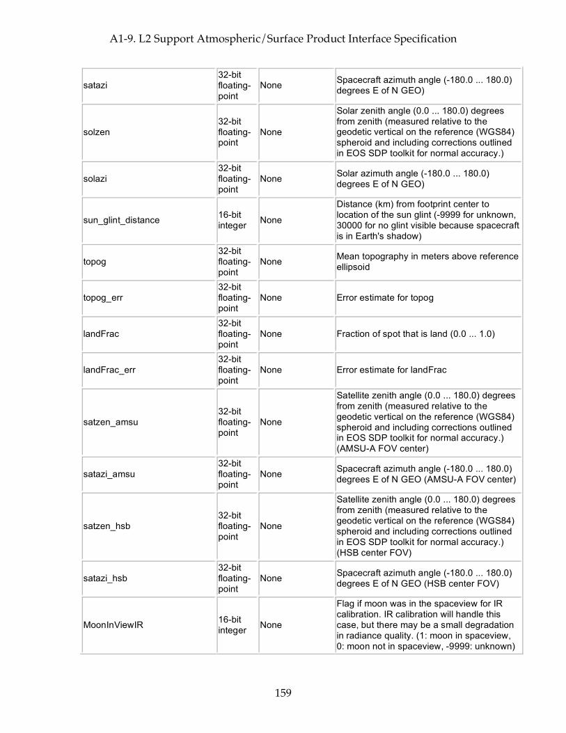
A1-9. L2 Support Atmospheric/Surface Product Interface Specification
159
satazi 32-bit floating-point
None Spacecraft azimuth angle (-180.0 ... 180.0) degrees E of N GEO)
solzen 32-bit floating-point
None
Solar zenith angle (0.0 ... 180.0) degrees from zenith (measured relative to the geodetic vertical on the reference (WGS84) spheroid and including corrections outlined in EOS SDP toolkit for normal accuracy.)
solazi 32-bit floating-point
None Solar azimuth angle (-180.0 ... 180.0) degrees E of N GEO)
sun_glint_distance 16-bit integer None
Distance (km) from footprint center to location of the sun glint (-9999 for unknown, 30000 for no glint visible because spacecraft is in Earth's shadow)
topog 32-bit floating-point
None Mean topography in meters above reference ellipsoid
topog_err 32-bit floating-point
None Error estimate for topog
landFrac 32-bit floating-point
None Fraction of spot that is land (0.0 ... 1.0)
landFrac_err 32-bit floating-point
None Error estimate for landFrac
satzen_amsu 32-bit floating-point
None
Satellite zenith angle (0.0 ... 180.0) degrees from zenith (measured relative to the geodetic vertical on the reference (WGS84) spheroid and including corrections outlined in EOS SDP toolkit for normal accuracy.) (AMSU-A FOV center)
satazi_amsu 32-bit floating-point
None Spacecraft azimuth angle (-180.0 ... 180.0) degrees E of N GEO (AMSU-A FOV center)
satzen_hsb 32-bit floating-point
None
Satellite zenith angle (0.0 ... 180.0) degrees from zenith (measured relative to the geodetic vertical on the reference (WGS84) spheroid and including corrections outlined in EOS SDP toolkit for normal accuracy.) (HSB center FOV)
satazi_hsb 32-bit floating-point
None Spacecraft azimuth angle (-180.0 ... 180.0) degrees E of N GEO (HSB center FOV)
MoonInViewIR 16-bit integer None
Flag if moon was in the spaceview for IR calibration. IR calibration will handle this case, but there may be a small degradation in radiance quality. (1: moon in spaceview, 0: moon not in spaceview, -9999: unknown)
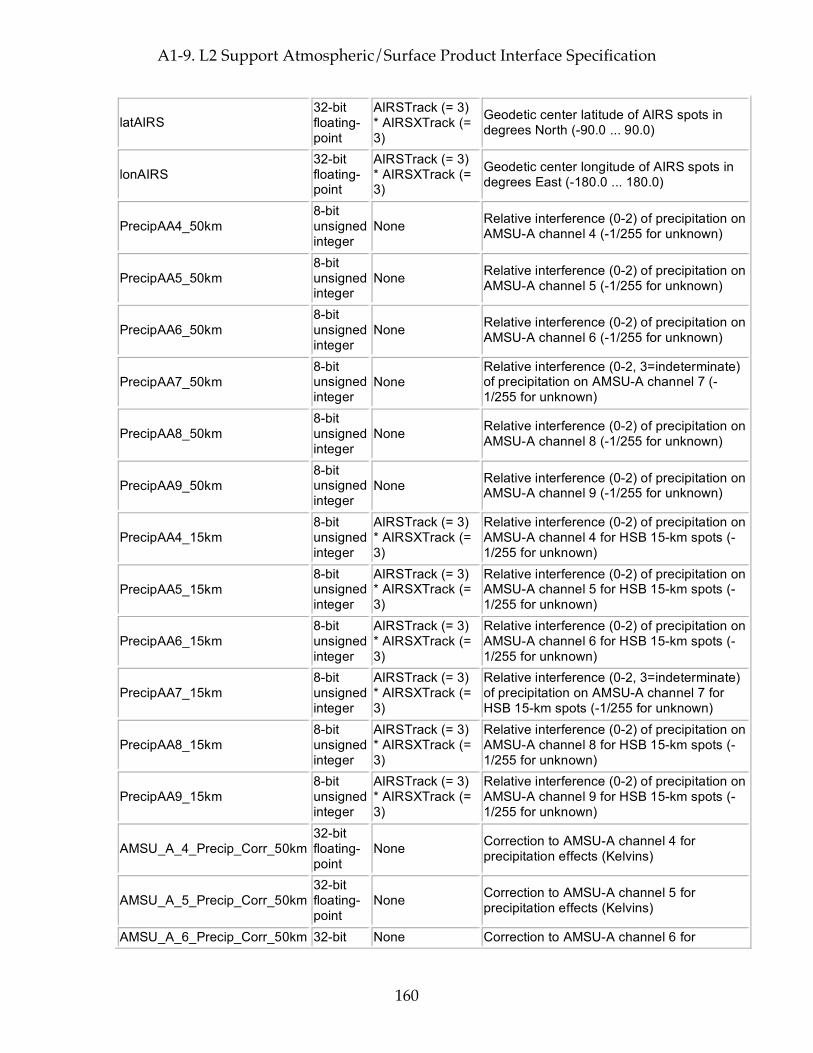
A1-9. L2 Support Atmospheric/Surface Product Interface Specification
160
latAIRS 32-bit floating-point
AIRSTrack (= 3) * AIRSXTrack (= 3)
Geodetic center latitude of AIRS spots in degrees North (-90.0 ... 90.0)
lonAIRS 32-bit floating-point
AIRSTrack (= 3) * AIRSXTrack (= 3)
Geodetic center longitude of AIRS spots in degrees East (-180.0 ... 180.0)
PrecipAA4_50km 8-bit unsigned integer
None Relative interference (0-2) of precipitation on AMSU-A channel 4 (-1/255 for unknown)
PrecipAA5_50km 8-bit unsigned integer
None Relative interference (0-2) of precipitation on AMSU-A channel 5 (-1/255 for unknown)
PrecipAA6_50km 8-bit unsigned integer
None Relative interference (0-2) of precipitation on AMSU-A channel 6 (-1/255 for unknown)
PrecipAA7_50km 8-bit unsigned integer
None Relative interference (0-2, 3=indeterminate) of precipitation on AMSU-A channel 7 (-1/255 for unknown)
PrecipAA8_50km 8-bit unsigned integer
None Relative interference (0-2) of precipitation on AMSU-A channel 8 (-1/255 for unknown)
PrecipAA9_50km 8-bit unsigned integer
None Relative interference (0-2) of precipitation on AMSU-A channel 9 (-1/255 for unknown)
PrecipAA4_15km 8-bit unsigned integer
AIRSTrack (= 3) * AIRSXTrack (= 3)
Relative interference (0-2) of precipitation on AMSU-A channel 4 for HSB 15-km spots (-1/255 for unknown)
PrecipAA5_15km 8-bit unsigned integer
AIRSTrack (= 3) * AIRSXTrack (= 3)
Relative interference (0-2) of precipitation on AMSU-A channel 5 for HSB 15-km spots (-1/255 for unknown)
PrecipAA6_15km 8-bit unsigned integer
AIRSTrack (= 3) * AIRSXTrack (= 3)
Relative interference (0-2) of precipitation on AMSU-A channel 6 for HSB 15-km spots (-1/255 for unknown)
PrecipAA7_15km 8-bit unsigned integer
AIRSTrack (= 3) * AIRSXTrack (= 3)
Relative interference (0-2, 3=indeterminate) of precipitation on AMSU-A channel 7 for HSB 15-km spots (-1/255 for unknown)
PrecipAA8_15km 8-bit unsigned integer
AIRSTrack (= 3) * AIRSXTrack (= 3)
Relative interference (0-2) of precipitation on AMSU-A channel 8 for HSB 15-km spots (-1/255 for unknown)
PrecipAA9_15km 8-bit unsigned integer
AIRSTrack (= 3) * AIRSXTrack (= 3)
Relative interference (0-2) of precipitation on AMSU-A channel 9 for HSB 15-km spots (-1/255 for unknown)
AMSU_A_4_Precip_Corr_50km 32-bit floating-point
None Correction to AMSU-A channel 4 for precipitation effects (Kelvins)
AMSU_A_5_Precip_Corr_50km 32-bit floating-point
None Correction to AMSU-A channel 5 for precipitation effects (Kelvins)
AMSU_A_6_Precip_Corr_50km 32-bit None Correction to AMSU-A channel 6 for
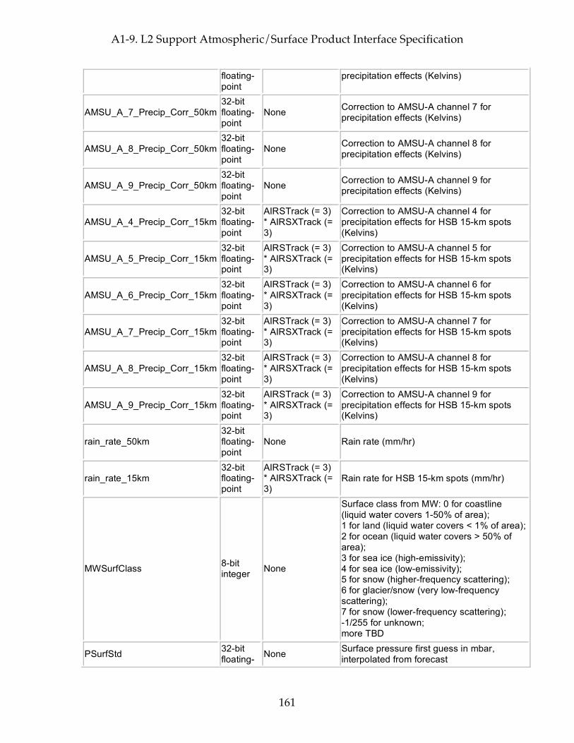
A1-9. L2 Support Atmospheric/Surface Product Interface Specification
161
floating-point
precipitation effects (Kelvins)
AMSU_A_7_Precip_Corr_50km 32-bit floating-point
None Correction to AMSU-A channel 7 for precipitation effects (Kelvins)
AMSU_A_8_Precip_Corr_50km 32-bit floating-point
None Correction to AMSU-A channel 8 for precipitation effects (Kelvins)
AMSU_A_9_Precip_Corr_50km 32-bit floating-point
None Correction to AMSU-A channel 9 for precipitation effects (Kelvins)
AMSU_A_4_Precip_Corr_15km 32-bit floating-point
AIRSTrack (= 3) * AIRSXTrack (= 3)
Correction to AMSU-A channel 4 for precipitation effects for HSB 15-km spots (Kelvins)
AMSU_A_5_Precip_Corr_15km 32-bit floating-point
AIRSTrack (= 3) * AIRSXTrack (= 3)
Correction to AMSU-A channel 5 for precipitation effects for HSB 15-km spots (Kelvins)
AMSU_A_6_Precip_Corr_15km 32-bit floating-point
AIRSTrack (= 3) * AIRSXTrack (= 3)
Correction to AMSU-A channel 6 for precipitation effects for HSB 15-km spots (Kelvins)
AMSU_A_7_Precip_Corr_15km 32-bit floating-point
AIRSTrack (= 3) * AIRSXTrack (= 3)
Correction to AMSU-A channel 7 for precipitation effects for HSB 15-km spots (Kelvins)
AMSU_A_8_Precip_Corr_15km 32-bit floating-point
AIRSTrack (= 3) * AIRSXTrack (= 3)
Correction to AMSU-A channel 8 for precipitation effects for HSB 15-km spots (Kelvins)
AMSU_A_9_Precip_Corr_15km 32-bit floating-point
AIRSTrack (= 3) * AIRSXTrack (= 3)
Correction to AMSU-A channel 9 for precipitation effects for HSB 15-km spots (Kelvins)
rain_rate_50km 32-bit floating-point
None Rain rate (mm/hr)
rain_rate_15km 32-bit floating-point
AIRSTrack (= 3) * AIRSXTrack (= 3)
Rain rate for HSB 15-km spots (mm/hr)
MWSurfClass 8-bit integer None
Surface class from MW: 0 for coastline (liquid water covers 1-50% of area); 1 for land (liquid water covers < 1% of area); 2 for ocean (liquid water covers > 50% of area); 3 for sea ice (high-emissivity); 4 for sea ice (low-emissivity); 5 for snow (higher-frequency scattering); 6 for glacier/snow (very low-frequency scattering); 7 for snow (lower-frequency scattering); -1/255 for unknown; more TBD
PSurfStd 32-bit floating- None Surface pressure first guess in mbar,
interpolated from forecast
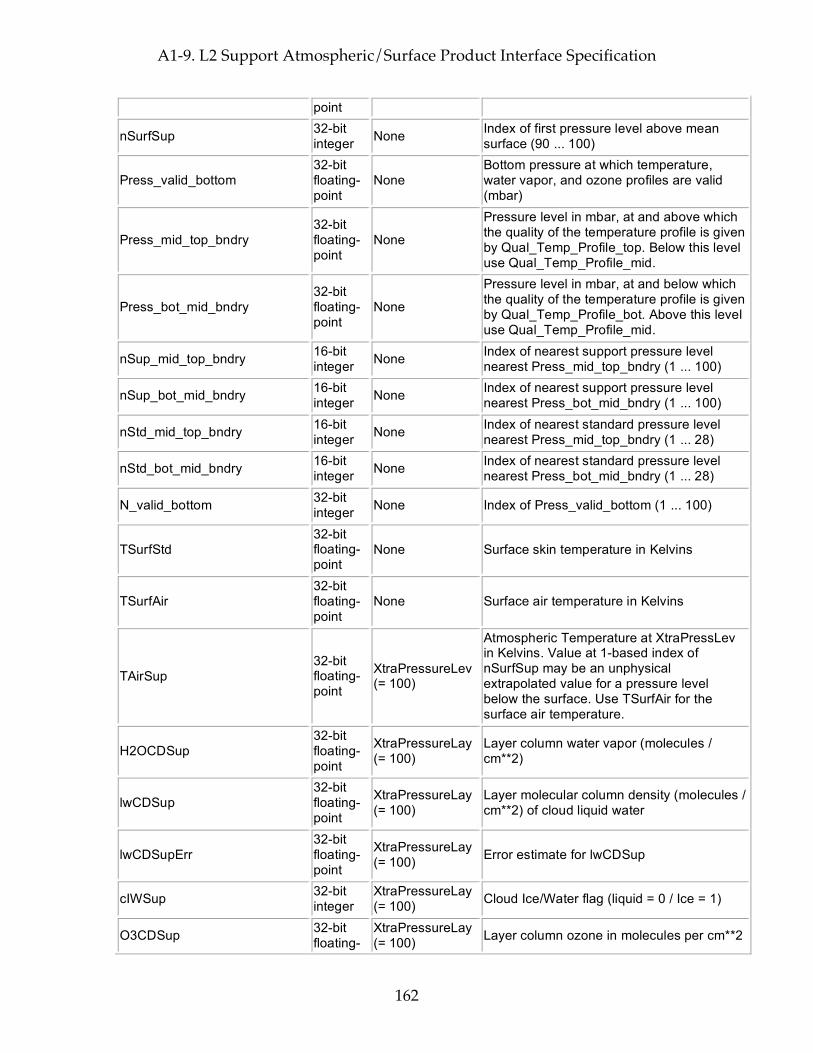
A1-9. L2 Support Atmospheric/Surface Product Interface Specification
162
point
nSurfSup 32-bit integer None Index of first pressure level above mean
surface (90 ... 100)
Press_valid_bottom 32-bit floating-point
None Bottom pressure at which temperature, water vapor, and ozone profiles are valid (mbar)
Press_mid_top_bndry 32-bit floating-point
None
Pressure level in mbar, at and above which the quality of the temperature profile is given by Qual_Temp_Profile_top. Below this level use Qual_Temp_Profile_mid.
Press_bot_mid_bndry 32-bit floating-point
None
Pressure level in mbar, at and below which the quality of the temperature profile is given by Qual_Temp_Profile_bot. Above this level use Qual_Temp_Profile_mid.
nSup_mid_top_bndry 16-bit integer None Index of nearest support pressure level
nearest Press_mid_top_bndry (1 ... 100)
nSup_bot_mid_bndry 16-bit integer None Index of nearest support pressure level
nearest Press_bot_mid_bndry (1 ... 100)
nStd_mid_top_bndry 16-bit integer None Index of nearest standard pressure level
nearest Press_mid_top_bndry (1 ... 28)
nStd_bot_mid_bndry 16-bit integer None Index of nearest standard pressure level
nearest Press_bot_mid_bndry (1 ... 28)
N_valid_bottom 32-bit integer None Index of Press_valid_bottom (1 ... 100)
TSurfStd 32-bit floating-point
None Surface skin temperature in Kelvins
TSurfAir 32-bit floating-point
None Surface air temperature in Kelvins
TAirSup 32-bit floating-point
XtraPressureLev (= 100)
Atmospheric Temperature at XtraPressLev in Kelvins. Value at 1-based index of nSurfSup may be an unphysical extrapolated value for a pressure level below the surface. Use TSurfAir for the surface air temperature.
H2OCDSup 32-bit floating-point
XtraPressureLay (= 100)
Layer column water vapor (molecules / cm**2)
lwCDSup 32-bit floating-point
XtraPressureLay (= 100)
Layer molecular column density (molecules / cm**2) of cloud liquid water
lwCDSupErr 32-bit floating-point
XtraPressureLay (= 100) Error estimate for lwCDSup
cIWSup 32-bit integer
XtraPressureLay (= 100) Cloud Ice/Water flag (liquid = 0 / Ice = 1)
O3CDSup 32-bit floating-
XtraPressureLay (= 100) Layer column ozone in molecules per cm**2
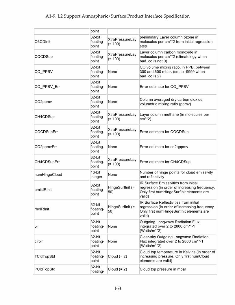
A1-9. L2 Support Atmospheric/Surface Product Interface Specification
163
point
O3CDInit 32-bit floating-point
XtraPressureLay (= 100)
preliminary Layer column ozone in molecules per cm**2 from initial regression step
COCDSup 32-bit floating-point
XtraPressureLay (= 100)
Layer column carbon monoxide in molecules per cm**2 (climatology when bad_co is not 0)
CO_PPBV 32-bit floating-point
None CO volume mixing ratio, in PPB, between 300 and 600 mbar. (set to -9999 when bad_co is 2)
CO_PPBV_Err 32-bit floating-point
None Error estimate for CO_PPBV
CO2ppmv 32-bit floating-point
None Column averaged dry carbon dioxide volumetric mixing ratio (ppmv)
CH4CDSup 32-bit floating-point
XtraPressureLay (= 100)
Layer column methane (in molecules per cm**2)
COCDSupErr 32-bit floating-point
XtraPressureLay (= 100) Error estimate for COCDSup
CO2ppmvErr 32-bit floating-point
None Error estimate for co2qppmv
CH4CDSupErr 32-bit floating-point
XtraPressureLay (= 100) Error estimate for CH4CDSup
numHingeCloud 16-bit integer None Number of hinge points for cloud emissivity
and reflectivity
emisIRInit 32-bit floating-point
HingeSurfInit (= 50)
IR Surface Emissivities from initial regression (in order of increasing frequency. Only first numHingeSurfInit elements are valid)
rhoIRInit 32-bit floating-point
HingeSurfInit (= 50)
IR Surface Reflectivities from initial regression (in order of increasing frequency. Only first numHingeSurfInit elements are valid)
olr 32-bit floating-point
None Outgoing Longwave Radiation Flux integrated over 2 to 2800 cm**-1 (Watts/m**2)
clrolr 32-bit floating-point
None Clear-sky Outgoing Longwave Radiation Flux integrated over 2 to 2800 cm**-1 (Watts/m**2)
TCldTopStd 32-bit floating-point
Cloud (= 2) Cloud top temperature in Kelvins (in order of increasing pressure. Only first numCloud elements are valid)
PCldTopStd 32-bit floating- Cloud (= 2) Cloud top pressure in mbar

A1-9. L2 Support Atmospheric/Surface Product Interface Specification
164
point
CldFrcStd 32-bit floating-point
AIRSTrack (= 3) * AIRSXTrack (= 3) * Cloud (= 2)
Cloud fraction (0.0 ... 1.0) assuming the cloud emissivity at 930 cm-1 is unity (in order of increasing pressure. Only first numCloud elements are valid)
TCldTopStdErr 32-bit floating-point
Cloud (= 2) Error estimate for TCldTopStd
PCldTopStdErr 32-bit floating-point
Cloud (= 2) Error estimate for PCldTopStd
CldFrcStdErr 32-bit floating-point
AIRSTrack (= 3) * AIRSXTrack (= 3) * Cloud (= 2)
Error estimate for CldFrcStd
cldFreq 32-bit floating-point
Cloud (= 2) * HingeCloud (= 7)
Frequencies for cloud emissivity and reflectivity (in order of increasing pressure. Only first numCloud elements are valid) (in order of increasing frequency. Only first numHingeCloud elements are valid)
CldEmis 32-bit floating-point
Cloud (= 2) * HingeCloud (= 7)
Ratio of cloud IR emissivity to that at 930 cm-1 (in order of increasing frequency. Only first numHingeCloud elements are valid)
CldRho 32-bit floating-point
Cloud (= 2) * HingeCloud (= 7) Future Cloud IR reflectivity -- DO NOT USE
CldEmisErr 32-bit floating-point
Cloud (= 2) * HingeCloud (= 7) Error estimate for CldEmis
CldRhoErr 32-bit floating-point
Cloud (= 2) * HingeCloud (= 7) Error estimate for CldRho
CldMapVis 8-bit integer
AIRSTrack (= 3) * AIRSXTrack (= 3) * VisTrack (= 9) * VisXTrack (= 8)
Map of clear/cloud pixel locations. (-1 = not known; 0 = clear; 1 = cloudy)
VarIndxAllVis 8-bit integer
AIRSTrack (= 3) * AIRSXTrack (= 3)
Variability index of all visible pixels in AIRS field-of-view (-1/255 for unknown)
VarIndxClrVis 8-bit integer
AIRSTrack (= 3) * AIRSXTrack (= 3)
Variability index of those visible pixels in AIRS field-of-view identified as clear (-1/255 for unknown)
rhoVis 8-bit integer
AIRSTrack (= 3) * AIRSXTrack (= 3) * VisTrack (= 9) * VisXTrack (= 8) * VChn (= 4)
Visible reflectivity integer percent (0 ... 100) (-1/255 for unknown)
cornerlats 32-bit floating-point
AIRSTrack (= 3) * AIRSXTrack (= 3) * VisGeoSpots
Geodetic Latitudes at the centers of the pixels at the corners of the IR footprint by channel in degrees North (-90.0 ... 90.0)

A1-9. L2 Support Atmospheric/Surface Product Interface Specification
165
(= 4) * VChn (= 4)
cornerlons 32-bit floating-point
AIRSTrack (= 3) * AIRSXTrack (= 3) * VisGeoSpots (= 4) * VChn (= 4)
Geodetic Longitudes at the centers of the pixels at the corners of the IR footprint by channel in degrees East (-180.0 ... 180.0)
fov_clear_flag 8-bit integer
AIRSTrack (= 3) * AIRSXTrack (= 3)
Preliminary clear flag based on MW/IR differences
fov_rad_resid 32-bit floating-point
AIRSTrack (= 3) * AIRSXTrack (= 3)
Preliminary residual between IR radiance and IR radiance predicted from MW
fov_psw_fr_lw_resid 32-bit floating-point
AIRSTrack (= 3) * AIRSXTrack (= 3)
Residual between shortwave radiance & shortwave radiance predicted from longwave
fov_psst_resid 32-bit floating-point
AIRSTrack (= 3) * AIRSXTrack (= 3)
Residual between Surface Temperatures and those predicted from window channel observations
fov_swlw_resid 32-bit floating-point
AIRSTrack (= 3) * AIRSXTrack (= 3)
residual between shortwave and longwave observations
fov_ocean_cc_test 32-bit floating-point
CCTest (= 10) * AIRSTrack (= 3) * AIRSXTrack (= 3)
clear tests for Ocean, test 1 to 10: 1: Brightness temperature of 965.323 cm-1; 2: Sea Surface Temperature (SST) - brightness temperature of 965.323 cm-1; 3: Brightness temperature of 2616.095 cm-1 - predicted from 8 micron window observations; 4: Brightness temperature of 2616.095 cm-1 - predicted from 11 micron window observations; 5: SST - predicted SST from window channels; 6: Store the value of SST; 7 - 10: TBD
prelim_clear_flag 8-bit integer None Preliminary clear flag based on IR spacial
inhomgeneity
prelim_rad_dev 32-bit floating-point
None Preliminary deviations between fov_rad_resids within a 3x3 FOV retrieval array
tsurf_forecast 32-bit floating-point
None Predicted surface temperature from forecast (K)
tsurf_diff_4um 32-bit floating-point
AIRSTrack (= 3) * AIRSXTrack (= 3)
Difference between SST predicted from AIRS 4 microns (2616 & 2707 cm^-1) observations and SST from a forecast model (K)
tsurf_diff_11um 32-bit floating-point
AIRSTrack (= 3) * AIRSXTrack (= 3)
Difference between SST predicted from AIRS 11 microns split window observations and SST from a forecast model, (K)

A1-9. L2 Support Atmospheric/Surface Product Interface Specification
166
spatial_coh_4um 32-bit floating-point
AIRSTrack (= 3) * AIRSXTrack (= 3)
This is the standard deviation of brightness temperature at 2616 cm^-1 over 3X3 AIRS footprints as a measure of spatial homogeneity.
spatial_coh_11um 32-bit floating-point
AIRSTrack (= 3) * AIRSXTrack (= 3)
This is the standard deviation of Difference between SST predicted form AIRS 11 microns split window observations and SST from a forecast model, (K)
cldHgtMapVis 8-bit integer
AIRSTrack (= 3) * AIRSXTrack (= 3) * VisTrack (= 9) * VisXTrack (= 8)
Map of low-cloud pixel locations. (-1=unknown, 0=not low-cloud, 1=low-cloud.)
cldHgtCntVis 8-bit integer
AIRSTrack (= 3) * AIRSXTrack (= 3)
Count of number of distinct cloud heights in visible data found in an AIRS field-of-view (-1/255 for unknown)
cldHgtCntVisErr 8-bit integer
AIRSTrack (= 3) * AIRSXTrack (= 3)
Error estimate for cldHgtCntVis
TAirMWOnly 32-bit floating-point
XtraPressureLev (= 100)
Air temperature in Kelvins from microwave-only retrieval
H2OCDMWOnly 32-bit floating-point
XtraPressureLay (= 100)
Layer column water vapor from microwave-only retrieval (molecules / cm**2)
TAirMWOnlyErr 32-bit floating-point
StdPressureLev (= 28)
Error estimate for TAirMWOnly (Note that error estimate only made at StdPressureLev points even though TAirMWOnly is estimated at XtraPressureLev points)
H2OCDMWOnlyErr 32-bit floating-point
StdPressureLay (= 28)
Error estimate for H2OCDMWOnly (Note that error estimate only made at StdPressureLay points even though H2OCDMWOnly is estimated at XtraPressureLay points)
TSurf1Ret 32-bit floating-point
None Surface temperature after first retrieval in Kelvins
TSurfAir1Ret 32-bit floating-point
None Surface air temperature after first retrieval in Kelvins
TAir1Ret 32-bit floating-point
XtraPressureLev (= 100) Air temperature after first retrieval in Kelvins
H2OCD1Ret 32-bit floating-point
XtraPressureLay (= 100)
Layer column water vapor after first retrieval (molecules / cm**2)
MW_psurf_range 8-bit integer None
Surface pressure check for MW-only retrieval product: bit 7: unused, set to zero; bit 6 (value 64): Invalid input; bit 5 (value 32): high input value error;

A1-9. L2 Support Atmospheric/Surface Product Interface Specification
167
bit 4 (value 16): low input value error; bit 3 (value 8): high input value warning; bit 2 (value 4): low input value warning; bit 1 (value 2): input value high, but not enough for warning; bit 0 (LSB, value 1): input value low, but not enough for warning
MW_tsurf_range 8-bit integer None
Retrieved surface temperature check for MW-only retrieval product: bit 7: unused, set to zero; bit 6 (value 64): Invalid input; bit 5 (value 32): high input value error; bit 4 (value 16): low input value error; bit 3 (value 8): high input value warning; bit 2 (value 4): low input value warning; bit 1 (value 2): input value high, but not enough for warning; bit 0 (LSB, value 1): input value low, but not enough for warning
MW_tair_range
Profile range check (see below)
None retrieved air temperature profile check for MW-only retrieval product
reg_psurf_range 8-bit integer None
Surface pressure check for regression retrieval product: bit 7: unused, set to zero; bit 6 (value 64): Invalid input; bit 5 (value 32): high input value error; bit 4 (value 16): low input value error; bit 3 (value 8): high input value warning; bit 2 (value 4): low input value warning; bit 1 (value 2): input value high, but not enough for warning; bit 0 (LSB, value 1): input value low, but not enough for warning
reg_tsurf_range 8-bit integer None
Retrieved surface temperature check for regression retrieval product: bit 7: unused, set to zero; bit 6 (value 64): Invalid input; bit 5 (value 32): high input value error; bit 4 (value 16): low input value error; bit 3 (value 8): high input value warning; bit 2 (value 4): low input value warning; bit 1 (value 2): input value high, but not enough for warning; bit 0 (LSB, value 1): input value low, but not enough for warning
reg_tair_range
Profile range check (see below)
None retrieved air temperature profile check for regression retrieval product
reg_h2ocd_range Profile None retrieved water vapor temperature profile
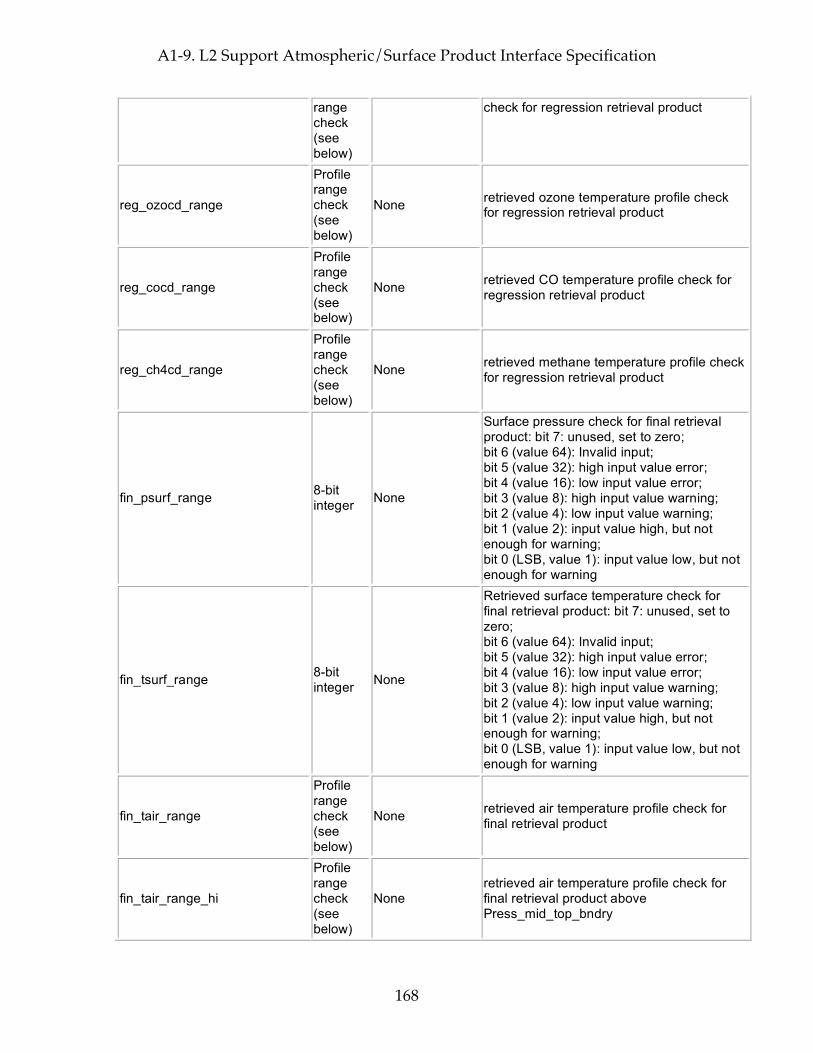
A1-9. L2 Support Atmospheric/Surface Product Interface Specification
168
range check (see below)
check for regression retrieval product
reg_ozocd_range
Profile range check (see below)
None retrieved ozone temperature profile check for regression retrieval product
reg_cocd_range
Profile range check (see below)
None retrieved CO temperature profile check for regression retrieval product
reg_ch4cd_range
Profile range check (see below)
None retrieved methane temperature profile check for regression retrieval product
fin_psurf_range 8-bit integer None
Surface pressure check for final retrieval product: bit 7: unused, set to zero; bit 6 (value 64): Invalid input; bit 5 (value 32): high input value error; bit 4 (value 16): low input value error; bit 3 (value 8): high input value warning; bit 2 (value 4): low input value warning; bit 1 (value 2): input value high, but not enough for warning; bit 0 (LSB, value 1): input value low, but not enough for warning
fin_tsurf_range 8-bit integer None
Retrieved surface temperature check for final retrieval product: bit 7: unused, set to zero; bit 6 (value 64): Invalid input; bit 5 (value 32): high input value error; bit 4 (value 16): low input value error; bit 3 (value 8): high input value warning; bit 2 (value 4): low input value warning; bit 1 (value 2): input value high, but not enough for warning; bit 0 (LSB, value 1): input value low, but not enough for warning
fin_tair_range
Profile range check (see below)
None retrieved air temperature profile check for final retrieval product
fin_tair_range_hi
Profile range check (see below)
None retrieved air temperature profile check for final retrieval product above Press_mid_top_bndry
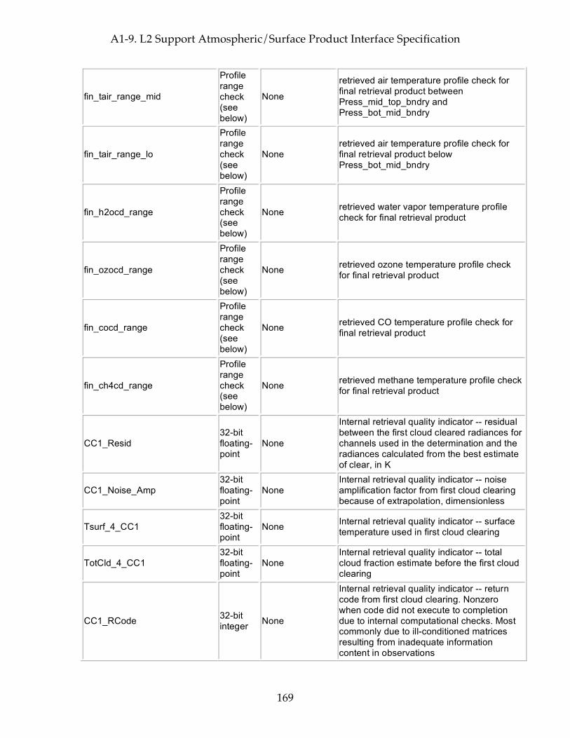
A1-9. L2 Support Atmospheric/Surface Product Interface Specification
169
fin_tair_range_mid
Profile range check (see below)
None
retrieved air temperature profile check for final retrieval product between Press_mid_top_bndry and Press_bot_mid_bndry
fin_tair_range_lo
Profile range check (see below)
None retrieved air temperature profile check for final retrieval product below Press_bot_mid_bndry
fin_h2ocd_range
Profile range check (see below)
None retrieved water vapor temperature profile check for final retrieval product
fin_ozocd_range
Profile range check (see below)
None retrieved ozone temperature profile check for final retrieval product
fin_cocd_range
Profile range check (see below)
None retrieved CO temperature profile check for final retrieval product
fin_ch4cd_range
Profile range check (see below)
None retrieved methane temperature profile check for final retrieval product
CC1_Resid 32-bit floating-point
None
Internal retrieval quality indicator -- residual between the first cloud cleared radiances for channels used in the determination and the radiances calculated from the best estimate of clear, in K
CC1_Noise_Amp 32-bit floating-point
None Internal retrieval quality indicator -- noise amplification factor from first cloud clearing because of extrapolation, dimensionless
Tsurf_4_CC1 32-bit floating-point
None Internal retrieval quality indicator -- surface temperature used in first cloud clearing
TotCld_4_CC1 32-bit floating-point
None Internal retrieval quality indicator -- total cloud fraction estimate before the first cloud clearing
CC1_RCode 32-bit integer None
Internal retrieval quality indicator -- return code from first cloud clearing. Nonzero when code did not execute to completion due to internal computational checks. Most commonly due to ill-conditioned matrices resulting from inadequate information content in observations

A1-9. L2 Support Atmospheric/Surface Product Interface Specification
170
CC2_RCode 32-bit integer None
Internal retrieval quality indicator -- return code from second cloud clearing. Nonzero when code did not execute to completion due to internal computational checks. Most commonly due to ill-conditioned matrices resulting from inadequate information content in observations
Phys_RCode 32-bit integer None
Internal retrieval quality indicator -- return code from physical retrieval. Nonzero when code did not execute to completion due to internal computational checks. Most commonly due to ill-conditioned matrices resulting from inadequate information content in observations
CCfinal_Resid 32-bit floating-point
None
Internal retrieval quality indicator -- residual between the final cloud cleared radiances for channels used in the determination and the radiances calculated from the best estimate of clear, in K
Tdiff_IR_MW_ret 32-bit floating-point
None
Internal retrieval quality indicator -- layer mean difference in lower atmosphere between final IR temperature retrieval and the last internal MW-only temperature determination. High values suggest problems with MW or problems with cloud clearing.
AMSU_Chans_Resid 32-bit floating-point
None
Internal retrieval quality indicator -- residual of selected AMSU channels (currently channel 5 only) against that calculated from the final IR retrieval state, K. High values suggest lower atmosphere retrieval disagrees with MW due to problems with MW or cloud clearing.
TotCld_4_CCfinal 32-bit floating-point
None
Internal retrieval quality indicator -- total cloud fraction estimated before final cloud clearing (as seen from above), dimensionless between zero and one
TotCld_below_500mb 32-bit floating-point
None
Internal retrieval quality indicator -- estimated final cloud fraction due only to clouds below 500 mbar (as seen from above), dimensionless between zero and one
CCfinal_Noise_Amp 32-bit floating-point
None Internal retrieval quality indicator -- noise amplification factor from final cloud clearing because of extrapolation, dimensionless
Surf_Resid_Ratio 32-bit floating-point
None Internal retrieval quality indicator -- residuals of surface channels as compared to predicted uncertainty (dimensionless factor)
Temp_Resid_Ratio 32-bit floating-point
None Internal retrieval quality indicator -- residuals of temperature channels as compared to predicted uncertainty (dimensionless factor)
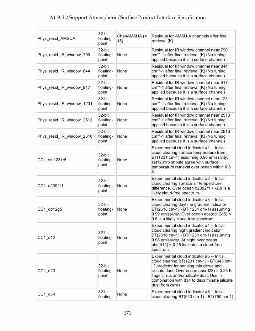
A1-9. L2 Support Atmospheric/Surface Product Interface Specification
171
Phys_resid_AMSUA 32-bit floating-point
ChanAMSUA (= 15)
Residual for AMSU-A channels after final retrieval (K)
Phys_resid_IR_window_790 32-bit floating-point
None Residual for IR window channel near 790 cm**-1 after final retrieval (K) (No tuning applied because it is a surface channel)
Phys_resid_IR_window_844 32-bit floating-point
None Residual for IR window channel near 844 cm**-1 after final retrieval (K) (No tuning applied because it is a surface channel)
Phys_resid_IR_window_917 32-bit floating-point
None Residual for IR window channel near 917 cm**-1 after final retrieval (K) (No tuning applied because it is a surface channel)
Phys_resid_IR_window_1231 32-bit floating-point
None Residual for IR window channel near 1231 cm**-1 after final retrieval (K) (No tuning applied because it is a surface channel)
Phys_resid_IR_window_2513 32-bit floating-point
None Residual for IR window channel near 2513 cm**-1 after final retrieval (K) (No tuning applied because it is a surface channel)
Phys_resid_IR_window_2616 32-bit floating-point
None Residual for IR window channel near 2616 cm**-1 after final retrieval (K) (No tuning applied because it is a surface channel)
CC1_sst1231r5 32-bit floating-point
None
Experimental cloud indicator #1 -- Initial cloud clearing surface temperature from BT(1231 cm-1) assuming 0.98 emissivity. sst1231r5 should agree with surface temperature retrieval over ocean within 0.5 K.
CC1_d2392r1 32-bit floating-point
None
Experimental cloud indicator #2 -- Initial cloud clearing surface air temperature difference. Over ocean d2392r1 > -2.0 is a likely cloud-free spectrum.
CC1_dd12g5 32-bit floating-point
None
Experimental cloud indicator #3 -- Initial cloud clearing daytime gradient indicator BT(2616 cm-1) - BT(1231 cm-1) assuming 0.99 emissivity. Over ocean abs(dd12g5) < 0.5 is a likely cloud-free spectrum.
CC1_d12 32-bit floating-point
None
Experimental cloud indicator #4 -- Initial cloud clearing night gradient indicator BT(2616 cm-1) - BT(1231 cm-1) assuming 0.98 emissivity. At night over ocean abs(d12) < 0.25 indicates a cloud-free spectrum.
CC1_d23 32-bit floating-point
None
Experimental cloud indicator #5 -- Initial cloud clearing BT(1231 cm-1) - BT(943 cm-1) predictor for sensing thin cirrus and silicate dust. Over ocean abs(d23) > 0.25 K flags cirrus and/or silicate dust. Use in combination with d34 to discriminate silicate dust from cirrus.
CC1_d34 32-bit floating- None Experimental cloud indicator #6 -- Initial
cloud clearing BT(943 cm-1) - BT(790 cm-1)

A1-9. L2 Support Atmospheric/Surface Product Interface Specification
172
point predictor for sensing thin cirrus. abs(d34) > 0.5 K indicates cirrus. Use in combination with d23.
CC1_lrt 32-bit floating-point
None
Experimental cloud indicator #7 -- Initial cloud clearing Lapse rate test. lrt > 3.5 K over tropical ocean indicates cloud-free data.
CC1_g5n 32-bit floating-point
None
Experimental cloud indicator #8 -- Initial cloud clearing Glint discriminator. Over ocean gn5 > 3 indicates a spectrum distorted by a sun glint
CCN_sst1231r5 32-bit floating-point
None
Experimental cloud indicator #1 -- Final cloud clearing surface temperature from BT(1231 cm-1) assuming 0.98 emissivity. sst1231r5 should agree with surface temperature retrieval over ocean within 0.5 K.
CCN_d2392r1 32-bit floating-point
None
Experimental cloud indicator #2 -- Final cloud clearing surface air temperature difference. Over ocean d2392r1 > -2.0 is a likely cloud-free spectrum.
CCN_dd12g5 32-bit floating-point
None
Experimental cloud indicator #3 -- Final cloud clearing daytime gradient indicator BT(2616 cm-1) - BT(1231 cm-1) assuming 0.99 emissivity. Over ocean abs(dd12g5) < 0.5 is a likely cloud-free spectrum.
CCN_d12 32-bit floating-point
None
Experimental cloud indicator #4 -- Final cloud clearing night gradient indicator BT(2616 cm-1) - BT(1231 cm-1) assuming 0.98 emissivity. At night over ocean abs(d12) < 0.25 indicates a cloud-free spectrum.
CCN_d23 32-bit floating-point
None
Experimental cloud indicator #5 -- Final cloud clearing BT(1231 cm-1) - BT(943 cm-1) predictor for sensing thin cirrus and silicate dust. Over ocean abs(d23) > 0.25 K flags cirrus and/or silicate dust. Use in combination with d34 to discriminate silicate dust from cirrus.
CCN_d34 32-bit floating-point
None
Experimental cloud indicator #6 -- Final cloud clearing BT(943 cm-1) - BT(790 cm-1) predictor for sensing thin cirrus. abs(d34) > 0.5 K indicates cirrus. Use in combination with d23.
CCN_lrt 32-bit floating-point
None
Experimental cloud indicator #7 -- Final cloud clearing Lapse rate test. lrt > 3.5 K over tropical ocean indicates cloud-free data.
CCN_g5n 32-bit floating-point
None Experimental cloud indicator #8 -- Final cloud clearing Glint discriminator. Over ocean gn5 > 3 indicates a spectrum
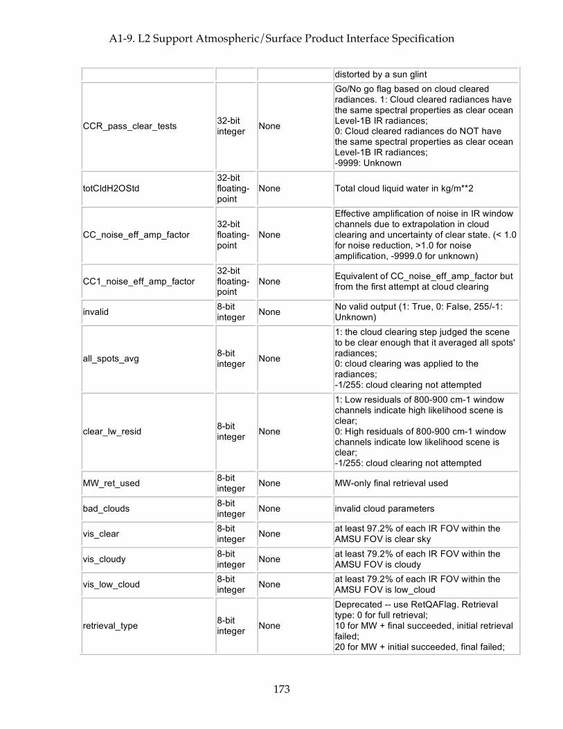
A1-9. L2 Support Atmospheric/Surface Product Interface Specification
173
distorted by a sun glint
CCR_pass_clear_tests 32-bit integer None
Go/No go flag based on cloud cleared radiances. 1: Cloud cleared radiances have the same spectral properties as clear ocean Level-1B IR radiances; 0: Cloud cleared radiances do NOT have the same spectral properties as clear ocean Level-1B IR radiances; -9999: Unknown
totCldH2OStd 32-bit floating-point
None Total cloud liquid water in kg/m**2
CC_noise_eff_amp_factor 32-bit floating-point
None
Effective amplification of noise in IR window channels due to extrapolation in cloud clearing and uncertainty of clear state. (< 1.0 for noise reduction, >1.0 for noise amplification, -9999.0 for unknown)
CC1_noise_eff_amp_factor 32-bit floating-point
None Equivalent of CC_noise_eff_amp_factor but from the first attempt at cloud clearing
invalid 8-bit integer None No valid output (1: True, 0: False, 255/-1:
Unknown)
all_spots_avg 8-bit integer None
1: the cloud clearing step judged the scene to be clear enough that it averaged all spots' radiances; 0: cloud clearing was applied to the radiances; -1/255: cloud clearing not attempted
clear_lw_resid 8-bit integer None
1: Low residuals of 800-900 cm-1 window channels indicate high likelihood scene is clear; 0: High residuals of 800-900 cm-1 window channels indicate low likelihood scene is clear; -1/255: cloud clearing not attempted
MW_ret_used 8-bit integer None MW-only final retrieval used
bad_clouds 8-bit integer None invalid cloud parameters
vis_clear 8-bit integer None at least 97.2% of each IR FOV within the
AMSU FOV is clear sky
vis_cloudy 8-bit integer None at least 79.2% of each IR FOV within the
AMSU FOV is cloudy
vis_low_cloud 8-bit integer None at least 79.2% of each IR FOV within the
AMSU FOV is low_cloud
retrieval_type 8-bit integer None
Deprecated -- use RetQAFlag. Retrieval type: 0 for full retrieval; 10 for MW + final succeeded, initial retrieval failed; 20 for MW + initial succeeded, final failed;
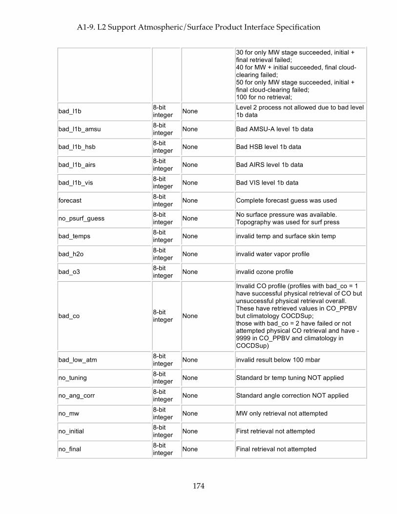
A1-9. L2 Support Atmospheric/Surface Product Interface Specification
174
30 for only MW stage succeeded, initial + final retrieval failed; 40 for MW + initial succeeded, final cloud-clearing failed; 50 for only MW stage succeeded, initial + final cloud-clearing failed; 100 for no retrieval;
bad_l1b 8-bit integer None Level 2 process not allowed due to bad level
1b data
bad_l1b_amsu 8-bit integer None Bad AMSU-A level 1b data
bad_l1b_hsb 8-bit integer None Bad HSB level 1b data
bad_l1b_airs 8-bit integer None Bad AIRS level 1b data
bad_l1b_vis 8-bit integer None Bad VIS level 1b data
forecast 8-bit integer None Complete forecast guess was used
no_psurf_guess 8-bit integer None No surface pressure was available.
Topography was used for surf press
bad_temps 8-bit integer None invalid temp and surface skin temp
bad_h2o 8-bit integer None invalid water vapor profile
bad_o3 8-bit integer None invalid ozone profile
bad_co 8-bit integer None
Invalid CO profile (profiles with bad_co = 1 have successful physical retrieval of CO but unsuccessful physical retrieval overall. These have retrieved values in CO_PPBV but climatology COCDSup; those with bad_co = 2 have failed or not attempted physical CO retrieval and have -9999 in CO_PPBV and climatology in COCDSup)
bad_low_atm 8-bit integer None invalid result below 100 mbar
no_tuning 8-bit integer None Standard br temp tuning NOT applied
no_ang_corr 8-bit integer None Standard angle correction NOT applied
no_mw 8-bit integer None MW only retrieval not attempted
no_initial 8-bit integer None First retrieval not attempted
no_final 8-bit integer None Final retrieval not attempted
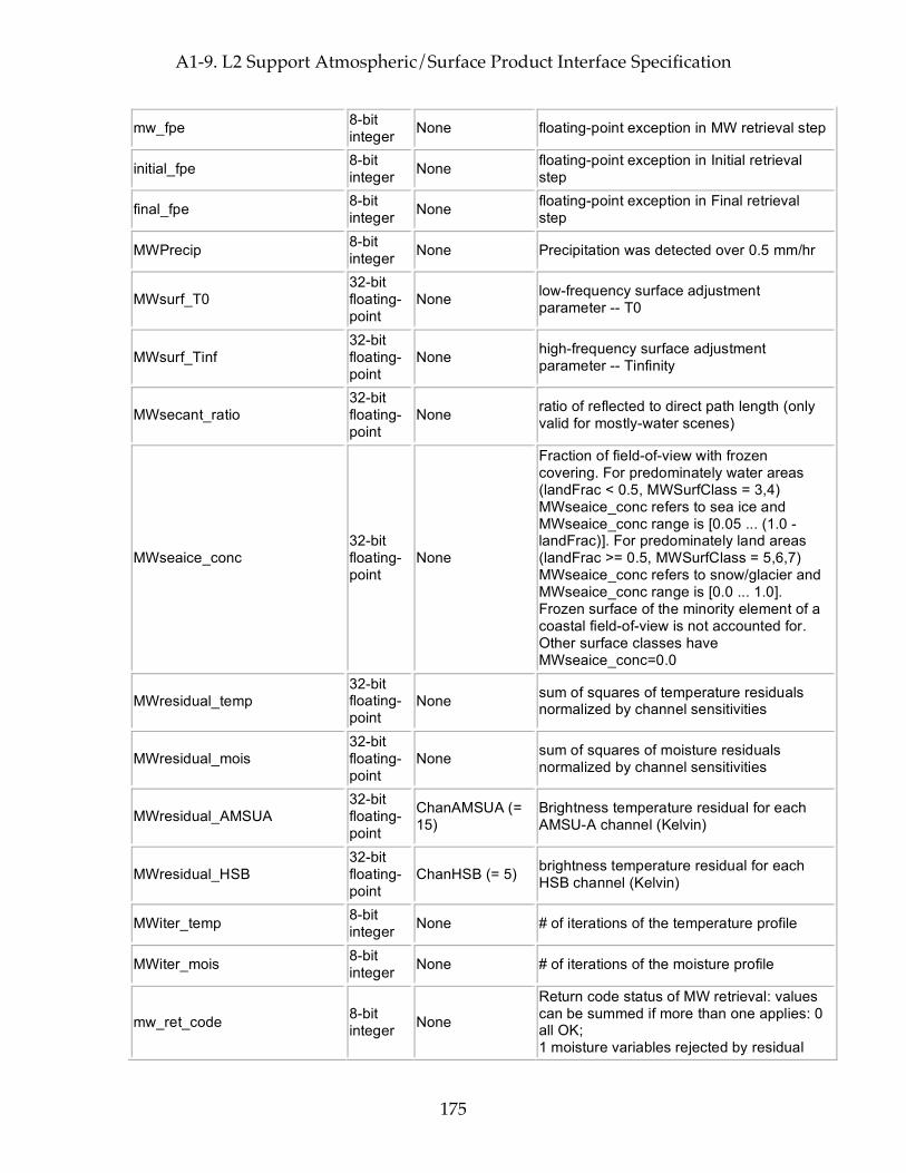
A1-9. L2 Support Atmospheric/Surface Product Interface Specification
175
mw_fpe 8-bit integer None floating-point exception in MW retrieval step
initial_fpe 8-bit integer None floating-point exception in Initial retrieval
step
final_fpe 8-bit integer None floating-point exception in Final retrieval
step
MWPrecip 8-bit integer None Precipitation was detected over 0.5 mm/hr
MWsurf_T0 32-bit floating-point
None low-frequency surface adjustment parameter -- T0
MWsurf_Tinf 32-bit floating-point
None high-frequency surface adjustment parameter -- Tinfinity
MWsecant_ratio 32-bit floating-point
None ratio of reflected to direct path length (only valid for mostly-water scenes)
MWseaice_conc 32-bit floating-point
None
Fraction of field-of-view with frozen covering. For predominately water areas (landFrac < 0.5, MWSurfClass = 3,4) MWseaice_conc refers to sea ice and MWseaice_conc range is [0.05 ... (1.0 - landFrac)]. For predominately land areas (landFrac >= 0.5, MWSurfClass = 5,6,7) MWseaice_conc refers to snow/glacier and MWseaice_conc range is [0.0 ... 1.0]. Frozen surface of the minority element of a coastal field-of-view is not accounted for. Other surface classes have MWseaice_conc=0.0
MWresidual_temp 32-bit floating-point
None sum of squares of temperature residuals normalized by channel sensitivities
MWresidual_mois 32-bit floating-point
None sum of squares of moisture residuals normalized by channel sensitivities
MWresidual_AMSUA 32-bit floating-point
ChanAMSUA (= 15)
Brightness temperature residual for each AMSU-A channel (Kelvin)
MWresidual_HSB 32-bit floating-point
ChanHSB (= 5) brightness temperature residual for each HSB channel (Kelvin)
MWiter_temp 8-bit integer None # of iterations of the temperature profile
MWiter_mois 8-bit integer None # of iterations of the moisture profile
mw_ret_code 8-bit integer None
Return code status of MW retrieval: values can be summed if more than one applies: 0 all OK; 1 moisture variables rejected by residual
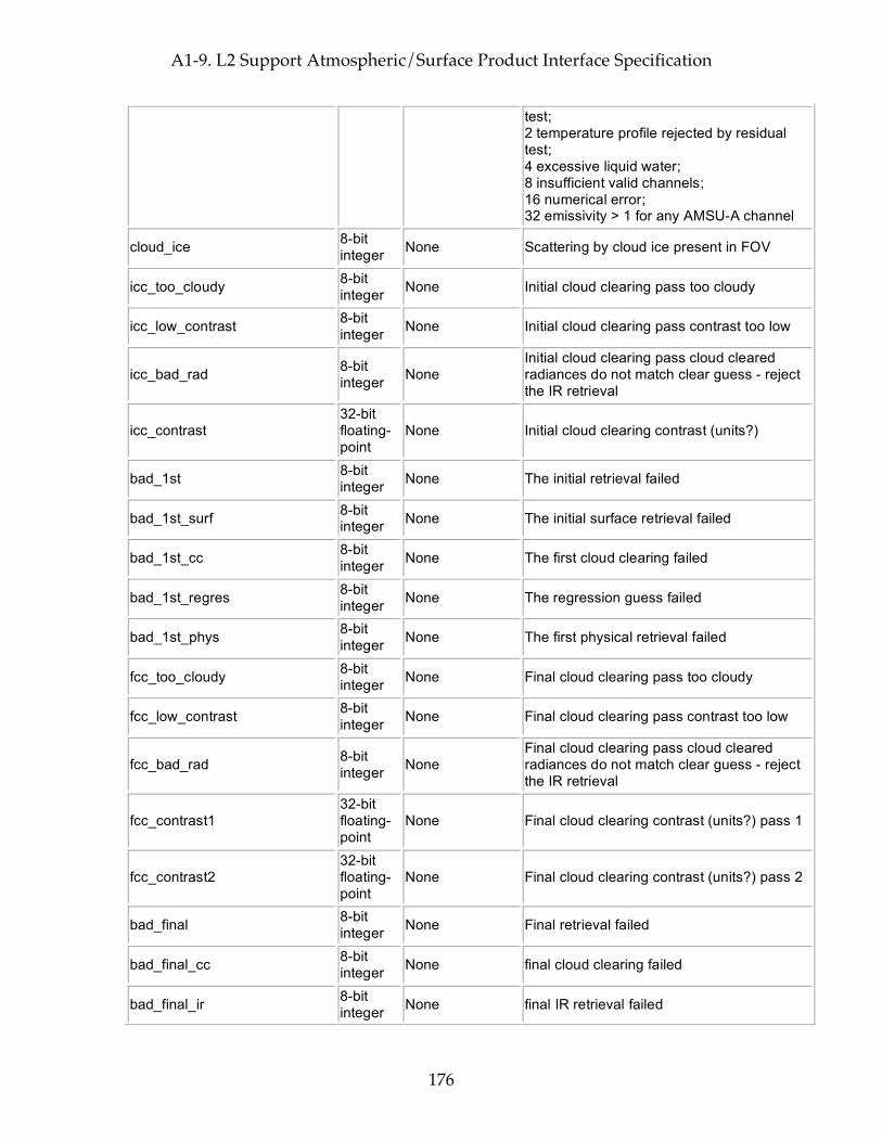
A1-9. L2 Support Atmospheric/Surface Product Interface Specification
176
test; 2 temperature profile rejected by residual test; 4 excessive liquid water; 8 insufficient valid channels; 16 numerical error; 32 emissivity > 1 for any AMSU-A channel
cloud_ice 8-bit integer None Scattering by cloud ice present in FOV
icc_too_cloudy 8-bit integer None Initial cloud clearing pass too cloudy
icc_low_contrast 8-bit integer None Initial cloud clearing pass contrast too low
icc_bad_rad 8-bit integer None
Initial cloud clearing pass cloud cleared radiances do not match clear guess - reject the IR retrieval
icc_contrast 32-bit floating-point
None Initial cloud clearing contrast (units?)
bad_1st 8-bit integer None The initial retrieval failed
bad_1st_surf 8-bit integer None The initial surface retrieval failed
bad_1st_cc 8-bit integer None The first cloud clearing failed
bad_1st_regres 8-bit integer None The regression guess failed
bad_1st_phys 8-bit integer None The first physical retrieval failed
fcc_too_cloudy 8-bit integer None Final cloud clearing pass too cloudy
fcc_low_contrast 8-bit integer None Final cloud clearing pass contrast too low
fcc_bad_rad 8-bit integer None
Final cloud clearing pass cloud cleared radiances do not match clear guess - reject the IR retrieval
fcc_contrast1 32-bit floating-point
None Final cloud clearing contrast (units?) pass 1
fcc_contrast2 32-bit floating-point
None Final cloud clearing contrast (units?) pass 2
bad_final 8-bit integer None Final retrieval failed
bad_final_cc 8-bit integer None final cloud clearing failed
bad_final_ir 8-bit integer None final IR retrieval failed

A1-9. L2 Support Atmospheric/Surface Product Interface Specification
177
bad_final_surf 8-bit integer None final surface ret failed
bad_final_temp 8-bit integer None final temp ret failed
bad_final_h2o 8-bit integer None final water vapor ret failed
bad_final_o3 8-bit integer None final ozone ret failed
bad_final_cloud 8-bit integer None final cloud ret failed
bad_cc_cld_ret 8-bit integer None Cloud clearing and cloud ret are inconsistent
MW_IR_ret_differ 8-bit integer None Microwave and IR temperature retrieval
differ too much - reject final IR retrieval
bad_MW_low_resid 8-bit integer None Microwave residuals in lower atmosphere
too large - reject final IR retrieval
MW_low_atm_resid 32-bit floating-point
None MW residual for lower atmosphere after final retrieval
final_AMSU_ret 8-bit integer None
0 for success; 1 for did not converge; 2 for residual too large
final_HSB_ret 8-bit integer None
0 for success; 1 for did not converge; 2 for residual too large
final_cloud_ret 8-bit integer None
0 for success; 1 for did not converge; 2 for residual too large
final_surf_ret 8-bit integer None
0 for success; 1 for did not converge; 2 for residual too large
final_temp_ret 8-bit integer None
0 for success; 1 for did not converge; 2 for residual too large
final_h2o_ret 8-bit integer None
0 for success; 1 for did not converge; 2 for residual too large
final_o3_ret 8-bit integer None
0 for success; 1 for did not converge; 2 for residual too large
final_ch4_ret 8-bit integer None
0 for success; 1 for did not converge; 2 for residual too large
final_co_ret 8-bit integer None
0 for success; 1 for did not converge; 2 for residual too large
final_co2_ret 8-bit integer None 0 for success;
1 for did not converge;
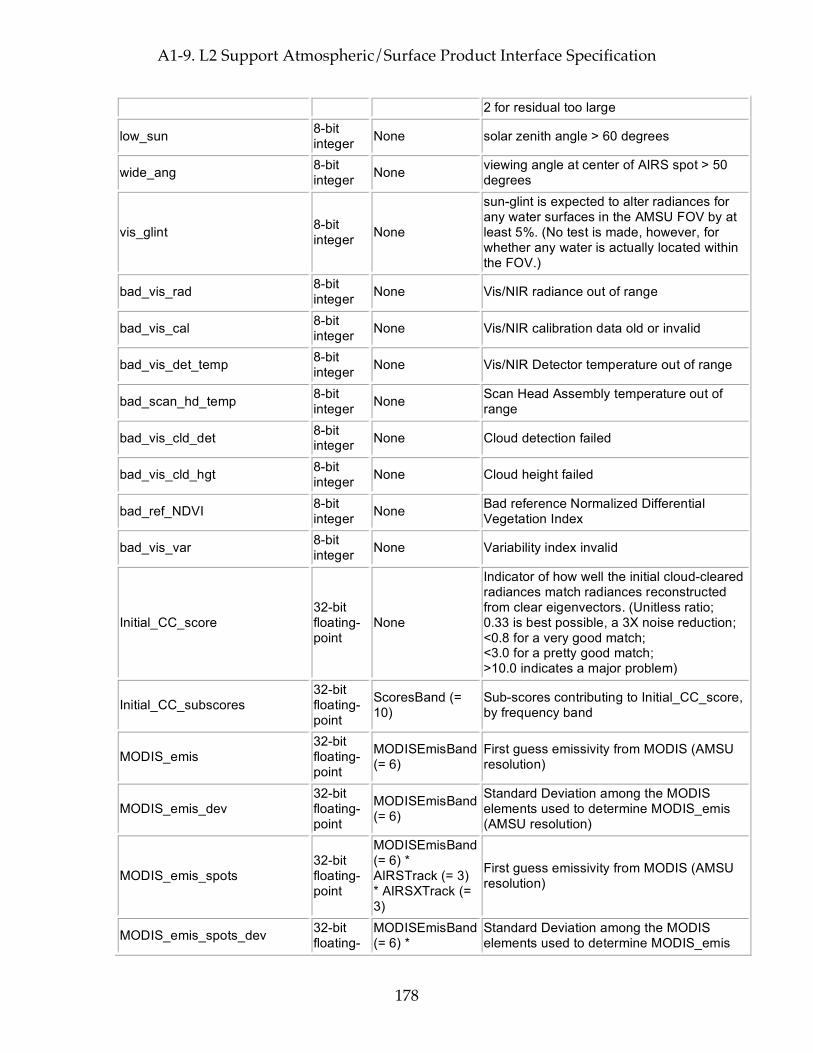
A1-9. L2 Support Atmospheric/Surface Product Interface Specification
178
2 for residual too large
low_sun 8-bit integer None solar zenith angle > 60 degrees
wide_ang 8-bit integer None viewing angle at center of AIRS spot > 50
degrees
vis_glint 8-bit integer None
sun-glint is expected to alter radiances for any water surfaces in the AMSU FOV by at least 5%. (No test is made, however, for whether any water is actually located within the FOV.)
bad_vis_rad 8-bit integer None Vis/NIR radiance out of range
bad_vis_cal 8-bit integer None Vis/NIR calibration data old or invalid
bad_vis_det_temp 8-bit integer None Vis/NIR Detector temperature out of range
bad_scan_hd_temp 8-bit integer None Scan Head Assembly temperature out of
range
bad_vis_cld_det 8-bit integer None Cloud detection failed
bad_vis_cld_hgt 8-bit integer None Cloud height failed
bad_ref_NDVI 8-bit integer None Bad reference Normalized Differential
Vegetation Index
bad_vis_var 8-bit integer None Variability index invalid
Initial_CC_score 32-bit floating-point
None
Indicator of how well the initial cloud-cleared radiances match radiances reconstructed from clear eigenvectors. (Unitless ratio; 0.33 is best possible, a 3X noise reduction; <0.8 for a very good match; <3.0 for a pretty good match; >10.0 indicates a major problem)
Initial_CC_subscores 32-bit floating-point
ScoresBand (= 10)
Sub-scores contributing to Initial_CC_score, by frequency band
MODIS_emis 32-bit floating-point
MODISEmisBand (= 6)
First guess emissivity from MODIS (AMSU resolution)
MODIS_emis_dev 32-bit floating-point
MODISEmisBand (= 6)
Standard Deviation among the MODIS elements used to determine MODIS_emis (AMSU resolution)
MODIS_emis_spots 32-bit floating-point
MODISEmisBand (= 6) * AIRSTrack (= 3) * AIRSXTrack (= 3)
First guess emissivity from MODIS (AMSU resolution)
MODIS_emis_spots_dev 32-bit floating-
MODISEmisBand (= 6) *
Standard Deviation among the MODIS elements used to determine MODIS_emis
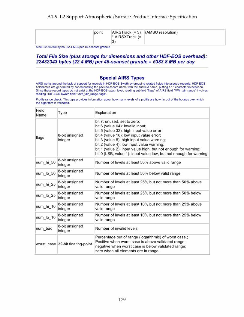
A1-9. L2 Support Atmospheric/Surface Product Interface Specification
179
point AIRSTrack (= 3) * AIRSXTrack (= 3)
(AMSU resolution)
Size: 22396500 bytes (22.4 MB) per 45-scanset granule
Total File Size (plus storage for dimensions and other HDF-EOS overhead): 22432343 bytes (22.4 MB) per 45-scanset granule = 5383.8 MB per day
Special AIRS Types AIRS works around the lack of support for records in HDF-EOS Swath by grouping related fields into pseudo-records. HDF-EOS fieldnames are generated by concatenating the pseudo-record name with the subfield name, putting a "." character in between. Since these record types do not exist at the HDF-EOS swath level, reading subfield "flags" of AIRS field "MW_tair_range" involves reading HDF-EOS Swath field "MW_tair_range.flags".
Profile range check: This type provides information about how many levels of a profile are how far out of the bounds over which the algorithm is validated.
Field Name Type Explanation
flags 8-bit unsigned integer
bit 7: unused, set to zero; bit 6 (value 64): Invalid input; bit 5 (value 32): high input value error; bit 4 (value 16): low input value error; bit 3 (value 8): high input value warning; bit 2 (value 4): low input value warning; bit 1 (value 2): input value high, but not enough for warning; bit 0 (LSB, value 1): input value low, but not enough for warning
num_hi_50 8-bit unsigned integer Number of levels at least 50% above valid range
num_lo_50 8-bit unsigned integer Number of levels at least 50% below valid range
num_hi_25 8-bit unsigned integer
Number of levels at least 25% but not more than 50% above valid range
num_lo_25 8-bit unsigned integer
Number of levels at least 25% but not more than 50% below valid range
num_hi_10 8-bit unsigned integer
Number of levels at least 10% but not more than 25% above valid range
num_lo_10 8-bit unsigned integer
Number of levels at least 10% but not more than 25% below valid range
num_bad 8-bit unsigned integer Number of invalid levels
worst_case 32-bit floating-point
Percentage out of range (logarithmic) of worst case.; Positive when worst case is above validated range; negative when worst case is below validated range; zero when all elements are in range.

A1-9. L2 Support Atmospheric/Surface Product Interface Specification
180
This page intentionally left blank.

A1-9. L2 Support Atmospheric/Surface Product Interface Specification
181

Appendix A2. Summary Browse Product Interface Specifications
182
Appendix A2. Summary Browse Product Interface Specifications AIRS Browse products are used as an aid to ordering AIRS data from the DAAC via the EOS Data Gateway (EDG). The user cycles through the AIRS Browse images for a high-level view of AIRS data products. The user may order AIRS science granules that correspond to features found in the browse images. The AIRS Summary browse products represent a twice-daily global snapshot of one day’s AIRS observations. The daily browse products will have “gores” between the satellite paths where there is no coverage for that day. Each summary browse product file consists of several unsigned 8-bit arrays. Each array is a 180 x 360 two-dimensional global map of the Earth’s surface at 1° x 1° resolution using a rectilinear projection. Each grid cell is a 1° x 1° square bounded by latitude and longitude lines. The longitudinal extent is from –180.0° to +180.0° with the prime meridian in the center of the image. The files are in HDF RIS8 (8-bit raster) format, and for each image within the file there is an associated color palette. Additionally, for each image there are descriptive annotations in HDF DFAN format. The annotations consist of image title, image description, and the minimum, mean, and maximum of the original data values and the corresponding pixel values. The minimum and maximum of the original data values may be used to annotate a color bar. Each array element has a value between 0 and 199 and is a re-scaled representation of a floating-point number (visible images are integer). The relationship between pixel value (pv) and input floating point data value (dv) is:
pv=(dv - minimum_dv)*(199/(maximum_dv – minimum_dv))+1 The AIRS summary browse product consists of five (5) summary browse package types, separated for ascending or descending orbital passes. A total of ten (10) AIRS summary browse package files are produced once per day. The products are associated with AIRS processing levels and instrument outputs of the AIRS science granules. The five AIRS summary product package types are described below.
1. AIRHBDBR - HSB Level 1B summary browse package type
AIRHDBDR consists of pixel representations of HSB Level 1B calibrated observed brightness temperatures. A limb adjustment algorithm is applied before the data values are converted to pixel values. AIRHBDBR contains 4 image arrays corresponding to 4 HSB channels (f0 = 183.31 GHz):
• 150.0 GHz (HSB Channel 2) • f0 +/- 1.0 GHz (HSB Channel 3) • f0 +/- 3.0 GHz (HSB Channel 4) • f0 +/- 7.0 GHz (HSB Channel 5)
2. AIRABDBR - AMSU-A Level 1B summary browse package type
AIRABDBR consists of pixel representations of AMSU-A Level 1B calibrated observed brightness temperatures. AIRABDBR is limb adjusted. AIRABDBR contains 8 image arrays corresponding to 8 AMSU-A channels (Center freq. GHz):

Appendix A2. Summary Browse Product Interface Specifications
183
• 23.8 GHz (AMSU-A Channel 1) • 31.4 GHz (AMSU-A Channel 2) • 50.3 GHz (AMSU-A Channel 3) • 52.8 GHz (AMSU-A Channel 4) • 53.596 +/- .115 GHz (AMSU-A Channel 5) • 54.4 GHz (AMSU-A Channel 6) • 54.94 GHz (AMSU-A Channel 7) • 89.0 GHz (AMSU-A Channel 15)
3. AIRIBDBR - AIRS Level 1B summary browse package type
AIRIBDBR consists of pixel representations of AIRS Level 1B calibrated observed radiances that have been converted to brightness temperature to increase the range of values. No limb adjustment is applied. AIRIBDBR contains 4 image arrays corresponding to 4 AIRS channels:
• 709.74 (200 mb temperature sensing channel) • 1040.14 (ozone sensing channel) • 1109.49 (window channel) • 1310.06 (water vapor sensing channel)
If, for any reason, any of the primary channels above are not available, each of the channels has a secondary option. The secondary channels are: 702.86, 1036.45, 1103.24, and 1330.90.
4. AIRI2DBR - AIRS Level 2 cloud-cleared radiance summary browse package type
AIRI2DBR consists of pixel representations of selected AIRS Level 2 cloud cleared radiances that have been converted to brightness temperature to increase the range of values. No limb adjustment is applied. The cloud-cleared radiance product is the infrared radiance emitted from cloud-free retrieved profiles, mWm**2/cm**-1/steradian. A single spectrum is derived from a suite of nine AIRS infrared spectra, nine HSB spectra and one AMSU-A spectrum. AIRI2DBR contains 4 image arrays corresponding to 4 AIRS channels:
• 709.74 (200 mb temperature sensing channel) • 1040.14 (ozone sensing channel) • 1109.49 (window channel) • 1310.06 (water vapor sensing channel)
If, for any reason, any of the primary channels above are not available, each of the channels has a secondary option. The secondary channels are: 702.86, 1036.45, 1103.24, and 1330.90.
5. AIRX2DBR - Level 2 retrieval summary browse package type
AIRX2DBR consists of pixel representations of selected AIRS Level 2 retrieved quantities. AIRX2DBR consists of 8 image arrays for ascending (daytime) nodes or 6 images for descending (night time) nodes for the following retrieved products:
• Cloud Fraction

Appendix A2. Summary Browse Product Interface Specifications
184
• Skin Surface Temperature (SST) • Total Water Vapor Burden • Total Ozone Burden • Microwave First Guess Liquid Water • Visible Percent Clear (Ascending Node Only)

Appendix A2. Summary Browse Product Interface Specifications
185
This page intentionally left blank.

A3. Level 3 Standard Product Interface Specification
186
Appendix A3. Level 3 Standard Product Interface Specification Interface Specification Version 4.0.9.0 2005-02-01 ESDT ShortName=”AIRX3STD”, “AIRX3ST8”,”AIRX3STM” Grid Names = “location”, “ascending”, “descending”, “ascending_MW_only”, “descending_MW_only” Level=”level3” Horizontal resolution= 1°x1° degree (360x180) Upper Left Point= -180.0, 90.0 Lower Right Point= 180.0, -90.0 Projection= GCTP_GEO
Geolocation Fields
These fields are within the location grid and document pertinent information for determining the location and characteristics of a given grid cell. Name Type Extra
Dimensions Explanation
Latitude 32-bit floating-point
None Array of 360 x 180 latitude values at the center of the grid box (Degrees).
Longitude 32-bit floating-point
None Array of 360 x 180 longitude values at the center of the grid box (Degrees).
LandSeaMask 16-bit integer None Land sea mask. 1 = land, 0 = ocean. (Unitless)

A3. Level 3 Standard Product Interface Specification
187
Attributes
These fields appear once per Level 3 granule. Name Type Extra
Dimensions Explanation
NumOfDays 32-bit integer
None Total number of days of input Level 2 data included in gridded maps.
AscendingGridStartTimeUTC String of 8-bit characters
None Begin time of mapped fields (UTC), ascending.
AscendingGridEndTimeUTC String of 8-bit characters
None End time of mapped fields (UTC), ascending.
DescendingGridStartTimeUTC String of 8-bit characters
None Begin time of mapped fields (UTC), descending.
DescendingGridEndTimeUTC String of 8-bit characters
None End time of mapped fields (UTC), descending.
TempPresLvlNum 32-bit floating point
24 Standard pressure (mb) for each of 24 levels in the atmosphere associated with temperature profiles and geopotential height. The array order is from the surface upward, in conformance with WMO standard. Note that the Level-3 pressure levels are a subset of Level-2 pressure levels and are constrained to begin at 1000.0 mb and end at 1.0 mb.
H2OpresLvlNum 32-bit floating point
12 Standard pressure (mb) for each of 12 layers in the atmosphere associated with AIRS Level-3 water vapor

A3. Level 3 Standard Product Interface Specification
188
profiles. The array order is from surface upward in accordance with the WMO standard. Note that Level-3 pressure levels for water vapor are constrained to be between 1000.0 and 100.0 mb.
Ascending and Descending Grid Fields
These fields (data, counts and standard deviation) appear once per ascending or
descending grid. The ‘_A’ or ‘_D’ following a parameter name identifies the
orbital node (A=ascending, D=descending) and thus, the grid. The exception is
the visible cloud fraction and associated counts and standard deviation. The
visible cloud fraction is found only in the ascending grid.
Name Type Extra Dimensions
Explanation
TotalCounts_A TotalCounts_D
16-bit integer None Total counts of all points that fell within a 1°x1° grid cell whether they were included in the final L3 product or not. Used for QC.
TotCldLiqH2O_A TotCldLiqH2O_D
32-bit floating point
None Total integrated column cloud liquid water. (kg/m2)
TotCldLiqH2O_A_sdev TotCldLiqH2O_D_sdev
32-bit floating point
None Standard deviation for cloud liquid water. (kg/m2)
TotCldLiqH2O_A_ct TotCldLiqH2O_D_ct
16-bit integer None Number of input points for cloud liquid water per 1°x1° grid cell. (Count)
TotH2OVap_A TotH2OVap_D
32-bit floating point
None Total integrated column water vapor burden. (kg/m2)
TotH2OVap_A_sdev TotH2OVap_D_sdev
32-bit floating point
None Standard deviation for precipitable water. (kg/m2)
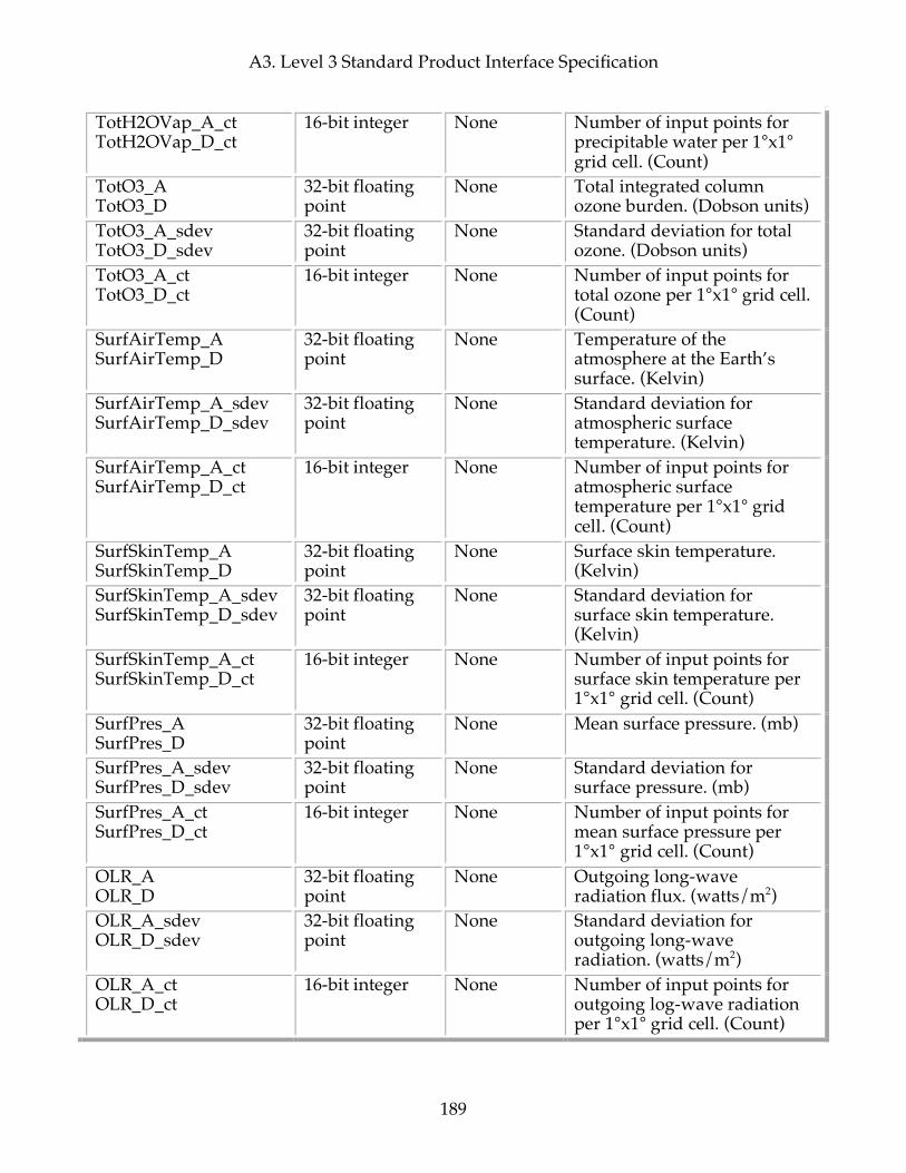
A3. Level 3 Standard Product Interface Specification
189
TotH2OVap_A_ct TotH2OVap_D_ct
16-bit integer None Number of input points for precipitable water per 1°x1° grid cell. (Count)
TotO3_A TotO3_D
32-bit floating point
None Total integrated column ozone burden. (Dobson units)
TotO3_A_sdev TotO3_D_sdev
32-bit floating point
None Standard deviation for total ozone. (Dobson units)
TotO3_A_ct TotO3_D_ct
16-bit integer None Number of input points for total ozone per 1°x1° grid cell. (Count)
SurfAirTemp_A SurfAirTemp_D
32-bit floating point
None Temperature of the atmosphere at the Earth’s surface. (Kelvin)
SurfAirTemp_A_sdev SurfAirTemp_D_sdev
32-bit floating point
None Standard deviation for atmospheric surface temperature. (Kelvin)
SurfAirTemp_A_ct SurfAirTemp_D_ct
16-bit integer None Number of input points for atmospheric surface temperature per 1°x1° grid cell. (Count)
SurfSkinTemp_A SurfSkinTemp_D
32-bit floating point
None Surface skin temperature. (Kelvin)
SurfSkinTemp_A_sdev SurfSkinTemp_D_sdev
32-bit floating point
None Standard deviation for surface skin temperature. (Kelvin)
SurfSkinTemp_A_ct SurfSkinTemp_D_ct
16-bit integer None Number of input points for surface skin temperature per 1°x1° grid cell. (Count)
SurfPres_A SurfPres_D
32-bit floating point
None Mean surface pressure. (mb)
SurfPres_A_sdev SurfPres_D_sdev
32-bit floating point
None Standard deviation for surface pressure. (mb)
SurfPres_A_ct SurfPres_D_ct
16-bit integer None Number of input points for mean surface pressure per 1°x1° grid cell. (Count)
OLR_A OLR_D
32-bit floating point
None Outgoing long-wave radiation flux. (watts/m2)
OLR_A_sdev OLR_D_sdev
32-bit floating point
None Standard deviation for outgoing long-wave radiation. (watts/m2)
OLR_A_ct OLR_D_ct
16-bit integer None Number of input points for outgoing log-wave radiation per 1°x1° grid cell. (Count)

A3. Level 3 Standard Product Interface Specification
190
ClrOLR_A ClrOLR_D
32-bit floating point
None Clear-sky outgoing long-wave radiation flux. (watts/m2)
ClrOLR_A_sdev ClrOLR_D_sdev
32-bit floating point
None Standard deviation for clear-sky outgoing long-wave radiation. (watts/m2
ClrOLR_A_ct ClrOLR_D_ct
16-bit integer None Number of input points for clear-sky outgoing log-wave radiation per 1°x1° grid cell. (Count)
EmisIR_A EmisIR_D
32-bit floating point
4 IR surface emissivity on a frequency grid (832, 961, 1203, 2616 cm-1.)
EmisIR_A_sdev EmisIR_D_sdev
32-bit floating point
4 Standard deviation for IR surface emissivity. (832, 961, 1203, 2616 cm-1.)
EmisIR_A_ct EmisIR_D_ct
16-bit integer 4 Number of input points for IR surface emissivity per 1°x1° grid cell and for each frequency grid point. (Count)
GPHeight_A GPHeight_D
32-bit floating point
24 Geopotential height in meters at 24 standard pressure levels from 1000. to 1.0 mb. (Meters)
GPHeight_A_sdev GPHeight_D_sdev
32-bit floating point
24 Standard deviation for Geopotential height. (Meters)
GPHeight_A_ct GPHeight_D_ct
16-bit integer 24 Number of input points for geopotential height per 1°x1° grid cell and at each pressure level. (Count)
CldFrc_A CldFrc_D
32-bit floating point
None Combined layer cloud fraction. (0-1). (Unitless)
CldFrc_A_sdev CldFrc_D_sdev
32-bit floating point
None Standard deviation of combined layer cloud fraction. (Unitless)
CldFrc_A_ct CldFrc_D_ct
16-bit integer None Number of input points for cloud fraction per 1°x1° grid cell. (Count)
CloudTopPres_A CloudTopPres_D
32-bit floating point
None Combined cloud top pressure (weighted by cloud fraction). (mb)
CloudTopPres_A_sdev CloudTopPres_D_sdev
32-bit floating point
None Standard deviation of combined cloud top pressure. (mb)
CloudTopPres_A_ct 16-bit integer None Number of input points for
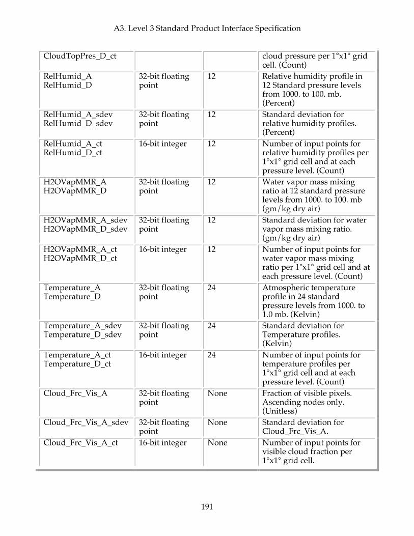
A3. Level 3 Standard Product Interface Specification
191
CloudTopPres_D_ct cloud pressure per 1°x1° grid cell. (Count)
RelHumid_A RelHumid_D
32-bit floating point
12 Relative humidity profile in 12 Standard pressure levels from 1000. to 100. mb. (Percent)
RelHumid_A_sdev RelHumid_D_sdev
32-bit floating point
12 Standard deviation for relative humidity profiles. (Percent)
RelHumid_A_ct RelHumid_D_ct
16-bit integer 12 Number of input points for relative humidity profiles per 1°x1° grid cell and at each pressure level. (Count)
H2OVapMMR_A H2OVapMMR_D
32-bit floating point
12 Water vapor mass mixing ratio at 12 standard pressure levels from 1000. to 100. mb (gm/kg dry air)
H2OVapMMR_A_sdev H2OVapMMR_D_sdev
32-bit floating point
12 Standard deviation for water vapor mass mixing ratio. (gm/kg dry air)
H2OVapMMR_A_ct H2OVapMMR_D_ct
16-bit integer 12 Number of input points for water vapor mass mixing ratio per 1°x1° grid cell and at each pressure level. (Count)
Temperature_A Temperature_D
32-bit floating point
24 Atmospheric temperature profile in 24 standard pressure levels from 1000. to 1.0 mb. (Kelvin)
Temperature_A_sdev Temperature_D_sdev
32-bit floating point
24 Standard deviation for Temperature profiles. (Kelvin)
Temperature_A_ct Temperature_D_ct
16-bit integer 24 Number of input points for temperature profiles per 1°x1° grid cell and at each pressure level. (Count)
Cloud_Frc_Vis_A 32-bit floating point
None Fraction of visible pixels. Ascending nodes only. (Unitless)
Cloud_Frc_Vis_A_sdev 32-bit floating point
None Standard deviation for Cloud_Frc_Vis_A.
Cloud_Frc_Vis_A_ct 16-bit integer None Number of input points for visible cloud fraction per 1°x1° grid cell.
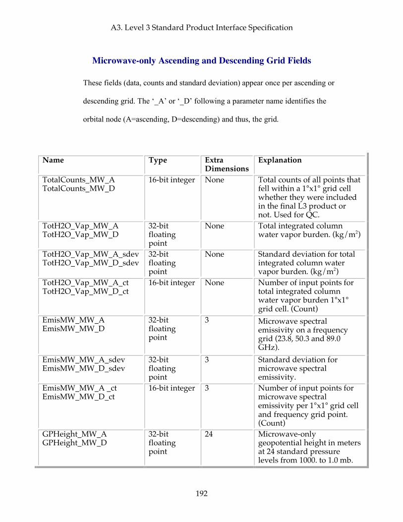
A3. Level 3 Standard Product Interface Specification
192
Microwave-only Ascending and Descending Grid Fields
These fields (data, counts and standard deviation) appear once per ascending or
descending grid. The ‘_A’ or ‘_D’ following a parameter name identifies the
orbital node (A=ascending, D=descending) and thus, the grid.
Name Type Extra Dimensions
Explanation
TotalCounts_MW_A TotalCounts_MW_D
16-bit integer None Total counts of all points that fell within a 1°x1° grid cell whether they were included in the final L3 product or not. Used for QC.
TotH2O_Vap_MW_A TotH2O_Vap_MW_D
32-bit floating point
None Total integrated column water vapor burden. (kg/m2)
TotH2O_Vap_MW_A_sdev TotH2O_Vap_MW_D_sdev
32-bit floating point
None Standard deviation for total integrated column water vapor burden. (kg/m2)
TotH2O_Vap_MW_A_ct TotH2O_Vap_MW_D_ct
16-bit integer None Number of input points for total integrated column water vapor burden 1°x1° grid cell. (Count)
EmisMW_MW_A EmisMW_MW_D
32-bit floating point
3 Microwave spectral emissivity on a frequency grid (23.8, 50.3 and 89.0 GHz).
EmisMW_MW_A_sdev EmisMW_MW_D_sdev
32-bit floating point
3 Standard deviation for microwave spectral emissivity.
EmisMW_MW_A _ct EmisMW_MW_D_ct
16-bit integer 3 Number of input points for microwave spectral emissivity per 1°x1° grid cell and frequency grid point. (Count)
GPHeight_MW_A GPHeight_MW_D
32-bit floating point
24 Microwave-only geopotential height in meters at 24 standard pressure levels from 1000. to 1.0 mb.
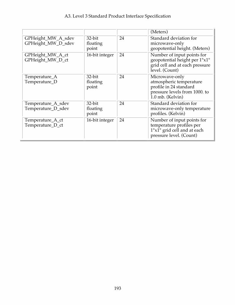
A3. Level 3 Standard Product Interface Specification
193
(Meters) GPHeight_MW_A_sdev GPHeight_MW_D_sdev
32-bit floating point
24 Standard deviation for microwave-only geopotential height. (Meters)
GPHeight_MW_A_ct GPHeight_MW_D_ct
16-bit integer 24 Number of input points for geopotential height per 1°x1° grid cell and at each pressure level. (Count)
Temperature_A Temperature_D
32-bit floating point
24 Microwave-only atmospheric temperature profile in 24 standard pressure levels from 1000. to 1.0 mb. (Kelvin)
Temperature_A_sdev Temperature_D_sdev
32-bit floating point
24 Standard deviation for microwave-only temperature profiles. (Kelvin)
Temperature_A_ct Temperature_D_ct
16-bit integer 24 Number of input points for temperature profiles per 1°x1° grid cell and at each pressure level. (Count)

A3. Level 3 Standard Product Interface Specification
194
This page intentionally left blank.

Appendix B. AIRS Filenames and Local Granule ID (LGID) Convention
195
Appendix B. AIRS Filenames and Local Granule ID (LGID) Convention AIRS filenames correspond to the "identifier" portion of the ECS Local Granule ID (LGID) standard: LGID:shortname:version:identifier where: ":" is a colon that acts as a separator of the parts of the LGID "LGID" is a literal string "shortname" is the ECS ESDT shortname "version" is the ECS ESDT version "identifier" is AIRS.yyyy.mm.dd.ggg.Lev.Instr_Prod.vm.m.r.b.lvid.Fttttttttttt.ext as detailed below We'll use identifiers of: AIRS.yyyy.mm.dd.ggg.Lev.Instr_Prod.vm.m.r.b.lvid.Fttttttttttt.ext Making the whole LGID: LGID:shortname:version:AIRS.yyyy.mm.dd.ggg.Lev.Instr_Prod.vm.m.r.b.lvid.Fttttttttttt.ext where: AIRS is the literal string "AIRS" to identify this as an AIRS-instrument-suite product. yyyy.mm.dd is the year/month/day of the start of the granule. ggg is the granule number in day (001 - 240). Note: Granule number is omitted for daily and multiday products . For browse products (L1B.Browse_AMSU, L1B.Browse_HSB, L1B.Browse_AIRS, L2.Browse_Ret, L2.Browse_CC) it is replaced by a single-character node-type identifier: "A" for Ascending "D" for Descending For L3 products (L3) there is no replacement. Note: The numbering system from 001 - 240 is closely tied to the idea of 6-minute granules triggered at precise intervals keyed to total elapsed time since start of year 1958. Test granules have been produced with
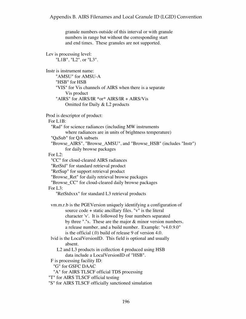
Appendix B. AIRS Filenames and Local Granule ID (LGID) Convention
196
granule numbers outside of this interval or with granule numbers in range but without the corresponding start and end times. These granules are not supported. Lev is processing level: "L1B", "L2", or "L3". Instr is instrument name: "AMSU" for AMSU-A "HSB" for HSB "VIS" for Vis channels of AIRS when there is a separate Vis product "AIRS" for AIRS/IR *or* AIRS/IR + AIRS/Vis Omitted for Daily & L2 products Prod is descriptor of product: For L1B: "Rad" for science radiances (including MW instruments where radiances are in units of brightness temperature) "QaSub" for QA subsets "Browse_AIRS", "Browse_AMSU", and "Browse_HSB" (includes "Instr") for daily browse packages For L2: "CC" for cloud-cleared AIRS radiances "RetStd" for standard retrieval product "RetSup" for support retrieval product "Browse_Ret" for daily retrieval browse packages "Browse_CC" for cloud-cleared daily browse packages For L3: "RetStdxxx" for standard L3 retrieval products vm.m.r.b is the PGEVersion uniquely identifying a configuration of source code + static ancillary files. "v" is the literal character 'v'. It is followed by four numbers separated by three "."s. These are the major & minor version numbers, a release number, and a build number. Example: "v4.0.9.0" is the official (.0) build of release 9 of version 4.0. lvid is the LocalVersionID. This field is optional and usually absent. L2 and L3 products in collection 4 produced using HSB data include a LocalVersionID of "HSB". F is processing facility ID: "G" for GSFC DAAC "A" for AIRS TLSCF official TDS processing "T" for AIRS TLSCF official testing "S" for AIRS TLSCF officially sanctioned simulation
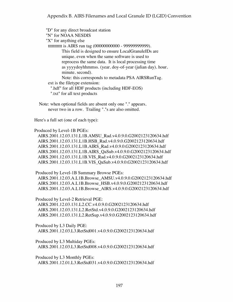
Appendix B. AIRS Filenames and Local Granule ID (LGID) Convention
197
"D" for any direct broadcast station "N" for NOAA NESDIS "X" for anything else ttttttttttt is AIRS run tag (00000000000 - 99999999999). This field is designed to ensure LocalGranuleIDs are unique, even when the same software is used to reprocess the same data. It is local processing time as yyyydoyhhmmss. (year, doy-of-year (julian day), hour, minute, second). Note: this corresponds to metadata PSA AIRSRunTag. ext is the filetype extension: ".hdf" for all HDF products (including HDF-EOS) ".txt" for all text products Note: when optional fields are absent only one "." appears, never two in a row. Trailing "."s are also omitted. Here's a full set (one of each type): Produced by Level-1B PGEs: AIRS.2001.12.03.131.L1B.AMSU_Rad.v4.0.9.0.G2002123120634.hdf AIRS.2001.12.03.131.L1B.HSB_Rad.v4.0.9.0.G2002123120634.hdf AIRS.2001.12.03.131.L1B.AIRS_Rad.v4.0.9.0.G2002123120634.hdf AIRS.2001.12.03.131.L1B.AIRS_QaSub.v4.0.9.0.G2002123120634.hdf AIRS.2001.12.03.131.L1B.VIS_Rad.v4.0.9.0.G2002123120634.hdf AIRS.2001.12.03.131.L1B.VIS_QaSub.v4.0.9.0.G2002123120634.hdf Produced by Level-1B Summary Browse PGEs: AIRS.2001.12.03.A.L1B.Browse_AMSU.v4.0.9.0.G2002123120634.hdf AIRS.2001.12.03.A.L1B.Browse_HSB.v4.0.9.0.G2002123120634.hdf AIRS.2001.12.03.A.L1B.Browse_AIRS.v4.0.9.0.G2002123120634.hdf Produced by Level-2 Retrieval PGE: AIRS.2001.12.03.131.L2.CC.v4.0.9.0.G2002123120634.hdf AIRS.2001.12.03.131.L2.RetStd.v4.0.9.0.G2002123120634.hdf AIRS.2001.12.03.131.L2.RetSup.v4.0.9.0.G2002123120634.hdf Produced by L3 Daily PGE: AIRS.2001.12.03.L3.RetStd001.v4.0.9.0.G2002123120634.hdf Produced by L3 Multiday PGEs: AIRS.2001.12.03.L3.RetStd008.v4.0.9.0.G2002123120634.hdf Produced by L3 Monthly PGEs: AIRS.2001.12.01.L3.RetStd031.v4.0.9.0.G2002123120634.hdf

Appendix B. AIRS Filenames and Local Granule ID (LGID) Convention
198
Produced by Level-2 Summary Browse PGEs: AIRS.2001.12.03.A.L2.Browse_Ret.v4.0.9.0.G2002123120634.hdf AIRS.2001.12.03.A.L2.Browse_CC.v4.0.9.0.G2002123120634.hdf
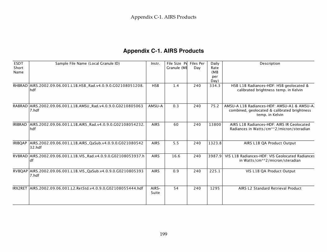
Appendix C-1. AIRS Products
199
Appendix C-1. AIRS Products
ESDT Short Name
Sample File Name (Local Granule ID) Instr. File Size Per Granule (MB)
Files Per Day
Daily Rate (MB per
Day)
Description
AIRHBRAD AIRS.2002.09.06.001.L1B.HSB_Rad.v4.0.9.0.G02108051208.hdf
HSB 1.4 240 334.3 HSB L1B Radiances-HDF: HSB geolocated & calibrated brightness temp. in Kelvin
AIRABRAD AIRS.2002.09.06.001.L1B.AMSU_Rad.v4.0.9.0.G02108050637.hdf
AMSU-A 0.3 240 75.2 AMSU-A L1B Radiances-HDF: AMSU-A1 & AMSU-A2 combined, geolocated & calibrated brightness
temp. in Kelvin
AIRIBRAD AIRS.2002.09.06.001.L1B.AIRS_Rad.v4.0.9.0.G02108054232.hdf
AIRS 60 240 13800 AIRS L1B Radiances-HDF: AIRS IR Geolocated Radiances in Watts/cm**2/micron/steradian
AIRIBQAP AIRS.2002.09.06.001.L1B.AIRS_QaSub.v4.0.9.0.G02108054232.hdf
AIRS 5.5 240 1323.8 AIRS L1B QA Product Output
AIRVBRAD AIRS.2002.09.06.001.L1B.VIS_Rad.v4.0.9.0.G02108053937.hdf
AIRS 16.6 240 3987.9 VIS L1B Radiances-HDF: VIS Geolocated Radiances in Watts/cm**2/micron/steradian
AIRVBQAP AIRS.2002.09.06.001.L1B.VIS_QaSub.v4.0.9.0.G02108053937.hdf
AIRS 0.9 240 225.1 VIS L1B QA Product Output
AIRX2RET AIRS.2002.09.06.001.L2.RetStd.v4.0.9.0.G02108055444.hdf AIRS-Suite
54 240 1295 AIRS L2 Standard Retrieval Product
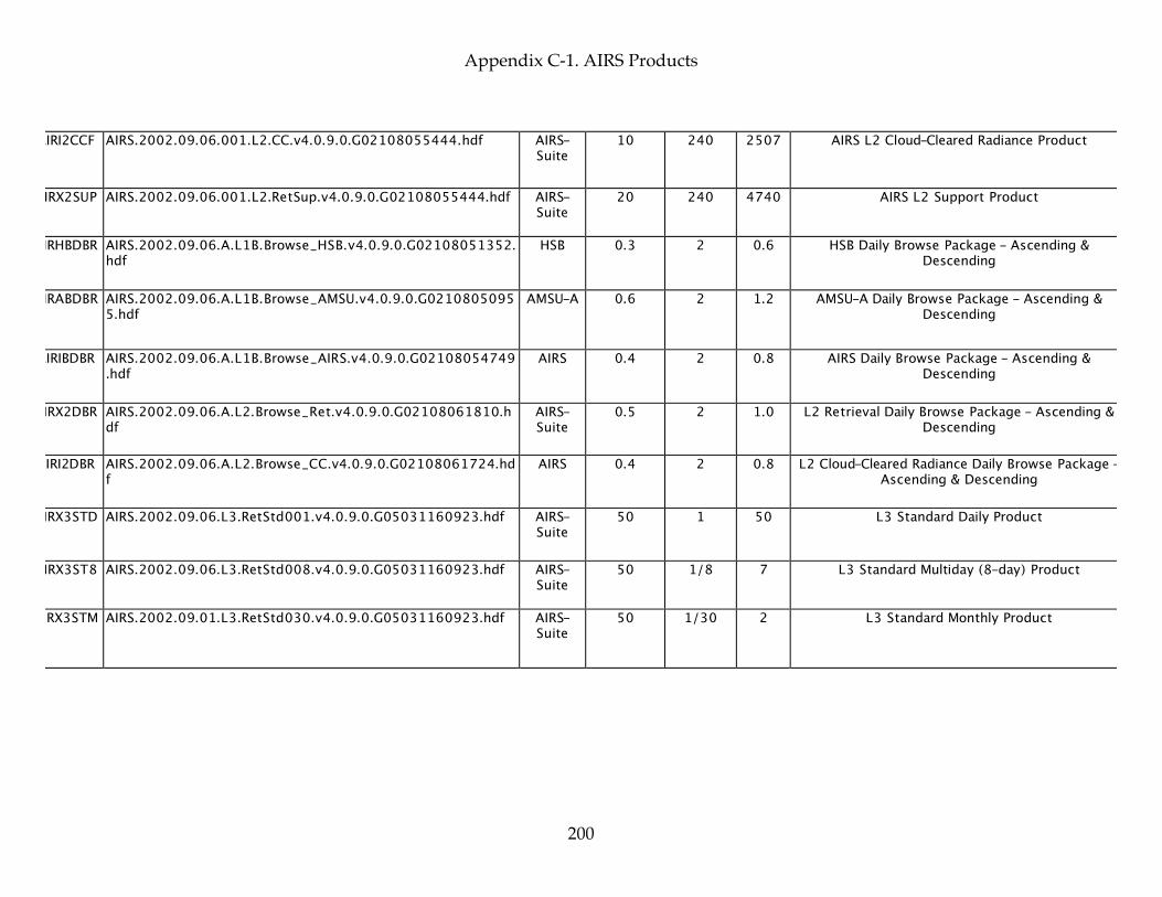
Appendix C-1. AIRS Products
200
AIRI2CCF AIRS.2002.09.06.001.L2.CC.v4.0.9.0.G02108055444.hdf AIRS-Suite
10 240 2507 AIRS L2 Cloud-Cleared Radiance Product
AIRX2SUP AIRS.2002.09.06.001.L2.RetSup.v4.0.9.0.G02108055444.hdf AIRS-Suite
20 240 4740 AIRS L2 Support Product
AIRHBDBR AIRS.2002.09.06.A.L1B.Browse_HSB.v4.0.9.0.G02108051352.hdf
HSB 0.3 2 0.6 HSB Daily Browse Package - Ascending & Descending
AIRABDBR AIRS.2002.09.06.A.L1B.Browse_AMSU.v4.0.9.0.G02108050955.hdf
AMSU-A 0.6 2 1.2 AMSU-A Daily Browse Package - Ascending & Descending
AIRIBDBR AIRS.2002.09.06.A.L1B.Browse_AIRS.v4.0.9.0.G02108054749.hdf
AIRS 0.4 2 0.8 AIRS Daily Browse Package - Ascending & Descending
AIRX2DBR AIRS.2002.09.06.A.L2.Browse_Ret.v4.0.9.0.G02108061810.hdf
AIRS-Suite
0.5 2 1.0 L2 Retrieval Daily Browse Package - Ascending & Descending
AIRI2DBR AIRS.2002.09.06.A.L2.Browse_CC.v4.0.9.0.G02108061724.hdf
AIRS 0.4 2 0.8 L2 Cloud-Cleared Radiance Daily Browse Package - Ascending & Descending
AIRX3STD AIRS.2002.09.06.L3.RetStd001.v4.0.9.0.G05031160923.hdf AIRS-Suite
50 1 50 L3 Standard Daily Product
AIRX3ST8 AIRS.2002.09.06.L3.RetStd008.v4.0.9.0.G05031160923.hdf AIRS-Suite
50 1/8 7 L3 Standard Multiday (8-day) Product
AIRX3STM AIRS.2002.09.01.L3.RetStd030.v4.0.9.0.G05031160923.hdf AIRS-Suite
50 1/30 2 L3 Standard Monthly Product
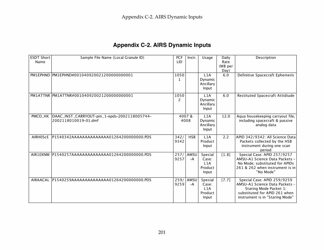
Appendix C-2. AIRS Dynamic Inputs
201
Appendix C-2. AIRS Dynamic Inputs ESDT Short
Name Sample File Name (Local Granule ID) PCF
LID Instr. Usage Daily
Rate (MB per
Day)
Description
PM1EPHND PM1EPHND#001040920021200000000001 10501
L1A Dynamic Ancillary
Input
6.0 Definitive Spacecraft Ephemeris
PM1ATTNR PM1ATTNR#001040920021200000000001 10502
L1A Dynamic Ancillary
Input
6.0 Restituted Spacecraft Attidtude
PMCO_HK DAAC_INST_CARRYOUT-pm_1-epds-2002118005744-2002118010019-01.dmf
4007 & 4008
L1A Dynamic Ancillary
Input
12.0 Aqua housekeeping carryout file, including spacecraft & passive
analog data
AIRH0ScE P1540342AAAAAAAAAAAAAA01264200000000.PDS 342/ 9342
HSB L1A Product
Input 2.2 APID 342/9342: All Science Data
Packets collected by the HSB instrument during one scan
period AIR10XNM P1540257AAAAAAAAAAAAAA01264200000000.PDS 257/
9257 AMSU
-A Special Case: L1A
Product Input
[1.8] Special Case: APID 257/9257 AMSU-A1 Science Data Packets - No Mode; substituted for APIDs
261 & 262 when instrument is in "No Mode"
AIRAACAL P1540259AAAAAAAAAAAAAA01264200000000.PDS 259/ 9259
AMSU-A
Special Case: L1A
Product Input
[7.7] Special Case: APID 259/9259 AMSU-A1 Science Data Packets -
Staring Mode Packet 1; substituted for APID 261 when instrument is in "Staring Mode"
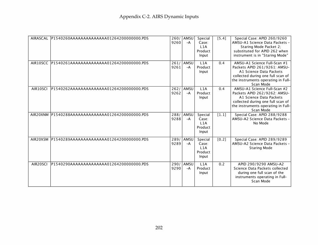
Appendix C-2. AIRS Dynamic Inputs
202
AIRASCAL P1540260AAAAAAAAAAAAAA01264200000000.PDS 260/ 9260
AMSU-A
Special Case: L1A
Product Input
[5.4] Special Case: APID 260/9260 AMSU-A1 Science Data Packets -
Staring Mode Packet 2; substituted for APID 262 when instrument is in "Staring Mode"
AIR10SCC P1540261AAAAAAAAAAAAAA01264200000000.PDS 261/ 9261
AMSU-A
L1A Product
Input 0.4 AMSU-A1 Science Full-Scan #1
Packets APID 261/9261: AMSU-A1 Science Data Packets
collected during one full scan of the instruments operating in Full-
Scan Mode AIR10SCI P1540262AAAAAAAAAAAAAA01264200000000.PDS 262/
9262 AMSU
-A L1A
Product Input
0.4 AMSU-A1 Science Full-Scan #2 Packets APID 262/9262: AMSU-
A1 Science Data Packets collected during one full scan of
the instruments operating in Full-Scan Mode
AIR20XNM P1540288AAAAAAAAAAAAAA01264200000000.PDS 288/ 9288
AMSU-A
Special Case: L1A
Product Input
[1.1] Special Case: APID 288/9288 AMSU-A2 Science Data Packets -
No Mode
AIR20XSM P1540289AAAAAAAAAAAAAA01264200000000.PDS 289/ 9289
AMSU-A
Special Case: L1A
Product Input
[0.2] Special Case: APID 289/9289 AMSU-A2 Science Data Packets -
Staring Mode
AIR20SCI P1540290AAAAAAAAAAAAAA01264200000000.PDS 290/ 9290
AMSU-A
L1A Product
Input 0.2 APID 290/9290 AMSU-A2
Science Data Packets collected during one full scan of the
instruments operating in Full-Scan Mode

Appendix C-2. AIRS Dynamic Inputs
203
AIRB0SCI P1540404AAAAAAAAAAAAAA01264200000000.PDS 404/ 9404
AIRS L1A Product
Input 624.9 AIRS Scene Packets APID
404/9404: Each packet in this collection contains ground
footprint data collected by the AIRS instrument for one footprint position. There are 90 of these
packets for each scan of the AIRS instrument.
AIRB0CAL P1540405AAAAAAAAAAAAAA01264200000000.PDS 405/ 9405
AIRS L1A Product
Input 6.9 AIRS Spacelook Packets APID
405/9405
AIRB0CAH P1540406AAAAAAAAAAAAAA01264200000000.PDS 406/ 9406
AIRS L1A Product
Input 6.9 AIRS Blackbody Packets APID
406/9406
AIRB0CAP P1540407AAAAAAAAAAAAAA01264200000000.PDS 407/ 9407
AIRS L1A Product
Input 6.9 AIRS Spectral/ Photometric
Packets APID 407/9407
AIRH1ENC P1540414AAAAAAAAAAAAAA01264200000000.PDS 414/ 9414
AIRS L1A Product
Input 6.9 AIRS STD HR ENG #1 Packets
APID 414/9414
AIRH2ENC P1540415AAAAAAAAAAAAAA01264200000000.PDS 415/ 9415
AIRS L1A Product
Input 6.9 AIRS STD HR ENG #2 Packets
APID 415/9415
AIRH1ENG P1540416AAAAAAAAAAAAAA01264200000000.PDS 416/ 9416
AIRS Special Case: L1A
Product Input
[6.9] Special Case: AIRS Flex HR ENG #2 Packets APID 416/9416;
substituted for APID 414 when instrument is commanded to
produce flexible engineering data AIRH2ENG P1540417AAAAAAAAAAAAAA01264200000000.PDS 417/
9417 AIRS Special
Case: L1A
Product Input
[6.9] Special Case: AIRS Flex HR ENG #2 Packets APID 417/9417;
substituted for APID 415 when instrument is commanded to
produce flexible engineering data

Appendix C-2. AIRS Dynamic Inputs
204
AVI3_ANH gblav.1998-09-12.T18Z.PGrbF03.anc 2203, 2213, 2223, 2233
& 2243 L2
Dynamic Ancillary
Input
328.0 Aviation forecast from model; 2203, 2213, 2223, 2233 &
2243: 3-hour aviation forecast for 18Z-hour, 00Z-hour, 06Z-
hour, 12Z-hour, 18Z-hour, respectively, cycle time on day prior to day in which granule
starts AVI6_ANH gblav.1998-09-12.T18Z.PGrbF06.anc 2206, 2216,
2226, 2236 & 2246
L2 Dynamic Ancillary
Input
328.0 Aviation forecast from model; 2206, 2216, 2226, 2236 &
2246: 6-hour aviation forecast for same model as 2203, 2213,
2223, 2233 & 2243, respectively
AVI9_ANH gblav.1998-09-12.T18Z.PGrbF09.anc 2209, 2219, 2229, 2239
& 2249 L2
Dynamic Ancillary
Input
328.0 Aviation forecast from model; 2209, 2219, 2229, 2239 &
2249: 9-hour aviation forecast for same model as 2203, 2213,
2223, 2233 & 2243, respectively
PREPQCH L2.gdas1.980913.T00Z.BufPREPda.anc 6400 RaObs RaObs PGE
Dynamic Ancillary
Input
12.0 NOAA Radiosonde Observations
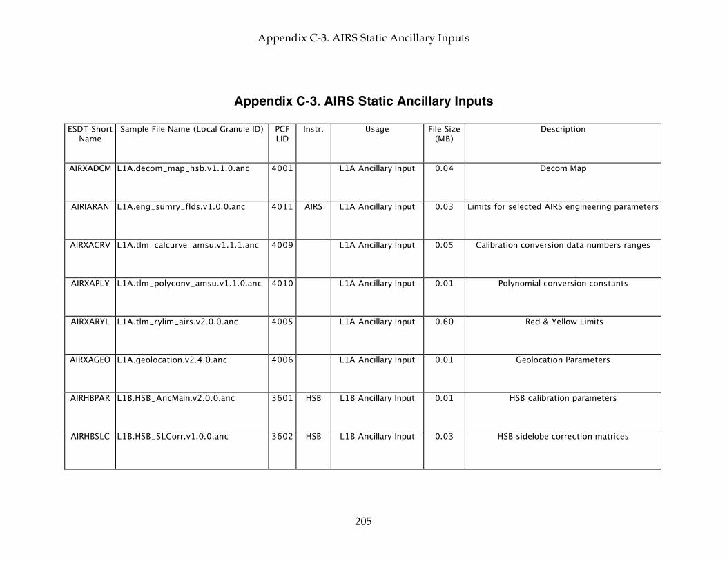
Appendix C-3. AIRS Static Ancillary Inputs
205
Appendix C-3. AIRS Static Ancillary Inputs ESDT Short
Name Sample File Name (Local Granule ID) PCF
LID Instr. Usage File Size
(MB) Description
AIRXADCM L1A.decom_map_hsb.v1.1.0.anc 4001 L1A Ancillary Input 0.04 Decom Map
AIRIARAN L1A.eng_sumry_flds.v1.0.0.anc 4011 AIRS L1A Ancillary Input 0.03 Limits for selected AIRS engineering parameters
AIRXACRV L1A.tlm_calcurve_amsu.v1.1.1.anc 4009 L1A Ancillary Input 0.05 Calibration conversion data numbers ranges
AIRXAPLY L1A.tlm_polyconv_amsu.v1.1.0.anc 4010 L1A Ancillary Input 0.01 Polynomial conversion constants
AIRXARYL L1A.tlm_rylim_airs.v2.0.0.anc 4005 L1A Ancillary Input 0.60 Red & Yellow Limits
AIRXAGEO L1A.geolocation.v2.4.0.anc 4006 L1A Ancillary Input 0.01 Geolocation Parameters
AIRHBPAR L1B.HSB_AncMain.v2.0.0.anc 3601 HSB L1B Ancillary Input 0.01 HSB calibration parameters
AIRHBSLC L1B.HSB_SLCorr.v1.0.0.anc 3602 HSB L1B Ancillary Input 0.03 HSB sidelobe correction matrices
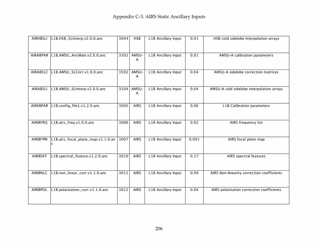
Appendix C-3. AIRS Static Ancillary Inputs
206
AIRHBSLI L1B.HSB_SLInterp.v2.0.0.anc 3604 HSB L1B Ancillary Input 0.01 HSB cold sidelobe interpolation arrays
AIRABPAR L1B.AMSU_AncMain.v2.0.0.anc 3501 AMSU-A
L1B Ancillary Input 0.01 AMSU-A calibration parameters
AIRABSLC L1B.AMSU_SLCorr.v1.0.0.anc 3502 AMSU-A
L1B Ancillary Input 0.04 AMSU-A sidelobe correction matrices
AIRABSLI L1B.AMSU_SLInterp.v2.0.0.anc 3504 AMSU-A
L1B Ancillary Input 0.04 AMSU-A cold sidelobe interpolation arrays
AIRXBPAR L1B.config_file1.v1.2.0.anc 3005 AIRS L1B Ancillary Input 0.06 L1B Calibration parameters
AIRIBFRQ L1B.airs_freq.v1.0.0.anc 3006 AIRS L1B Ancillary Input 0.02 AIRS frequency list
AIRIBFPM L1B.airs_focal_plane_map.v1.1.0.anc
3007 AIRS L1B Ancillary Input 0.001 AIRS focal plane map
AIRIBSFF L1B.spectral_feature.v1.2.0.anc 3010 AIRS L1B Ancillary Input 0.17 AIRS spectral features
AIRIBNLC L1B.non_linear_corr.v1.1.0.anc 3011 AIRS L1B Ancillary Input 0.09 AIRS Non-linearity correction coefficients
AIRIBPOL L1B.polarization_corr.v1.1.0.anc 3012 AIRS L1B Ancillary Input 0.04 AIRS polarization correction coefficients

Appendix C-3. AIRS Static Ancillary Inputs
207
AIRIBSVS L1B.space_view_sel.v1.0.0.anc 3013 AIRS L1B Ancillary Input 0.0007 AIRS space view selection parameters
AIRIBPOP L1B.popcorn_corr.v1.0.0.anc 3014 AIRS L1B Ancillary Input 0.01 AIRS popcorn correction parameters
AIRIBQPR L1B.airs_qa.v1.3.0.anc 3015 AIRS L1B Ancillary Input 0.3 AIRS QA parameters
AIRVBCPR L1B.vis_param.v1.0.0.anc 3009 AIRS L1B Ancillary Input 0.003 VIS calibration parameters
AIRVBQPR L1B.vis_qa.v1.1.0.anc 3016 AIRS L1B Ancillary Input 0.01 VIS QA parameters
AIRI2TMC L2b.trcoef.airs.v5.1.0.anc 2001 AIRS L2 Ancillary Input 36.9 AIRS IR Channel Transmittances
AIRA2TMC L2.trcoef.amsu.v3.0.0.anc 2002 AMSU-A
L2 Ancillary Input 0.13 AMSU-A Transmittances
AIRH2TMC L2.trcoef.hsb.v3.0.0.anc 2003 HSB L2 Ancillary Input 0.05 HSB Transmittances
AIRX2CLI L2.uars_clim.v1.0.1.anc 2005 L2 Ancillary Input 1.2 Climatology to set initial guess profiles
AIRX2AAC L2h.angle_adj_coef.v2.1.4.anc 2006 L2 Ancillary Input 40.9 Angle Correction Coefficients

Appendix C-3. AIRS Static Ancillary Inputs
208
AIRX2AEI L2.F.error_est.v1.0.0.anc 2007 L2 Ancillary Input 0.01 Ancillary error estimate inputs
AIRX2ABT L2h.brtemp_tuning_coef.v2.0.0.anc 2008 L2 Ancillary Input 29.4 BRTemp Tuning Coefficients
AIRI2SRD L2.airs_solar_rad.v5.1.0.anc 2009 AIRS L2 Ancillary Input 0.06 Solar radiances
AIRX2CAV L2.cloud_avg.v2.0.0.anc 2010 L2 Ancillary Input 0.24 Parameters determining channel averaging vs. extrapolation
AIRM2MEC L2.M.ecof_705.v1.0.0.anc 2011 L2 Ancillary Input 0.004 MW emissivity coefficients
AIRM2MCM L2.M.cov100av.v1.0.0.anc 2012 L2 Ancillary Input 0.22 MW temperature profile covariance matrix
AIRH2AAW L2.M.weight.hsb.v1.0.0.anc 2013 HSB L2 Ancillary Input 0.003 HSB ASCII Weight
AIRI2CHP L2.I.channel_prop.v5.1.2.anc 2014 AIRS L1B AIRS & L2 Ancillary Input
0.21 AIRS Channel properties
AIRI2OLR L2h.F.coef_olr.v1.0.0.anc 2015 L2 Ancillary Input 0.06 Outgoing longwave radiation coefficients
AIRX2ICW L2.I.peak_wgt.v2.0.0.anc 2021 L2 Ancillary Input 0.17 FIRST cloud clearing weighting function sensitivities
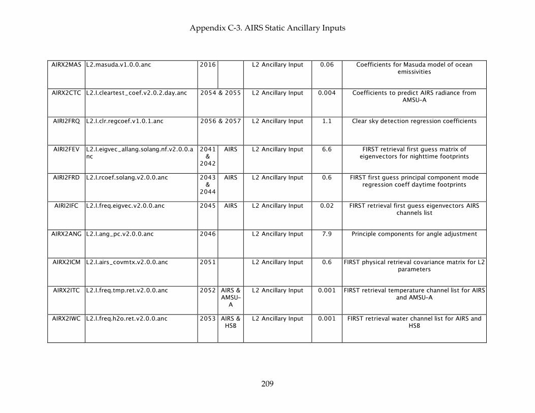
Appendix C-3. AIRS Static Ancillary Inputs
209
AIRX2MAS L2.masuda.v1.0.0.anc 2016 L2 Ancillary Input 0.06 Coefficients for Masuda model of ocean emissivities
AIRX2CTC L2.I.cleartest_coef.v2.0.2.day.anc 2054 & 2055 L2 Ancillary Input 0.004 Coefficients to predict AIRS radiance from AMSU-A
AIRI2FRQ L2.I.clr.regcoef.v1.0.1.anc 2056 & 2057 L2 Ancillary Input 1.1 Clear sky detection regression coefficients
AIRI2FEV L2.I.eigvec_allang.solang.nf.v2.0.0.anc
2041 &
2042 AIRS L2 Ancillary Input 6.6 FIRST retrieval first guess matrix of
eigenvectors for nighttime footprints
AIRI2FRD L2.I.rcoef.solang.v2.0.0.anc 2043 &
2044 AIRS L2 Ancillary Input 0.6 FIRST first guess principal component mode
regression coeff daytime footprints
AIRI2IFC L2.I.freq.eigvec.v2.0.0.anc 2045 AIRS L2 Ancillary Input 0.02 FIRST retrieval first guess eigenvectors AIRS channels list
AIRX2ANG L2.I.ang_pc.v2.0.0.anc 2046 L2 Ancillary Input 7.9 Principle components for angle adjustment
AIRX2ICM L2.I.airs_covmtx.v2.0.0.anc 2051 L2 Ancillary Input 0.6 FIRST physical retrieval covariance matrix for L2 parameters
AIRX2ITC L2.I.freq.tmp.ret.v2.0.0.anc 2052 AIRS & AMSU-
A L2 Ancillary Input 0.001 FIRST retrieval temperature channel list for AIRS
and AMSU-A
AIRX2IWC L2.I.freq.h2o.ret.v2.0.0.anc 2053 AIRS & HSB
L2 Ancillary Input 0.001 FIRST retrieval water channel list for AIRS and HSB
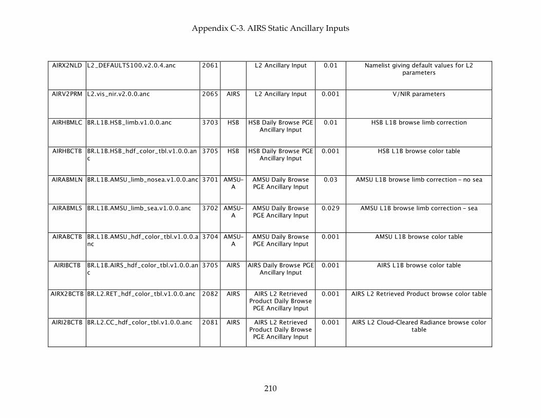
Appendix C-3. AIRS Static Ancillary Inputs
210
AIRX2NLD L2_DEFAULTS100.v2.0.4.anc 2061 L2 Ancillary Input 0.01 Namelist giving default values for L2 parameters
AIRV2PRM L2.vis_nir.v2.0.0.anc 2065 AIRS L2 Ancillary Input 0.001 V/NIR parameters
AIRHBMLC BR.L1B.HSB_limb.v1.0.0.anc 3703 HSB HSB Daily Browse PGE Ancillary Input
0.01 HSB L1B browse limb correction
AIRHBCTB BR.L1B.HSB_hdf_color_tbl.v1.0.0.anc
3705 HSB HSB Daily Browse PGE Ancillary Input
0.001 HSB L1B browse color table
AIRABMLN BR.L1B.AMSU_limb_nosea.v1.0.0.anc 3701 AMSU-A
AMSU Daily Browse PGE Ancillary Input
0.03 AMSU L1B browse limb correction - no sea
AIRABMLS BR.L1B.AMSU_limb_sea.v1.0.0.anc 3702 AMSU-A
AMSU Daily Browse PGE Ancillary Input
0.029 AMSU L1B browse limb correction - sea
AIRABCTB BR.L1B.AMSU_hdf_color_tbl.v1.0.0.anc
3704 AMSU-A
AMSU Daily Browse PGE Ancillary Input
0.001 AMSU L1B browse color table
AIRIBCTB BR.L1B.AIRS_hdf_color_tbl.v1.0.0.anc
3705 AIRS AIRS Daily Browse PGE Ancillary Input
0.001 AIRS L1B browse color table
AIRX2BCTB BR.L2.RET_hdf_color_tbl.v1.0.0.anc 2082 AIRS AIRS L2 Retrieved Product Daily Browse PGE Ancillary Input
0.001 AIRS L2 Retrieved Product browse color table
AIRI2BCTB BR.L2.CC_hdf_color_tbl.v1.0.0.anc 2081 AIRS AIRS L2 Retrieved Product Daily Browse PGE Ancillary Input
0.001 AIRS L2 Cloud-Cleared Radiance browse color table
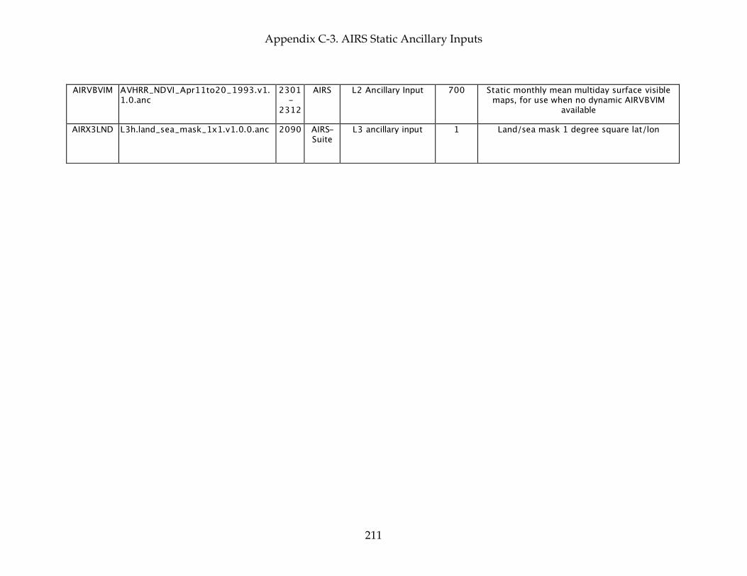
Appendix C-3. AIRS Static Ancillary Inputs
211
AIRVBVIM AVHRR_NDVI_Apr11to20_1993.v1.1.0.anc
2301-
2312 AIRS L2 Ancillary Input 700 Static monthly mean multiday surface visible
maps, for use when no dynamic AIRVBVIM available
AIRX3LND L3h.land_sea_mask_1x1.v1.0.0.anc 2090 AIRS-Suite
L3 ancillary input 1 Land/sea mask 1 degree square lat/lon
Appendix C-3. AIRS Static Ancillary Inputs
212
This page intentionally left blank.